SlideShare a Scribd company logo
1 of 175
Download to read offline
Compiled By:
1. Dr. Teferi Mekonnen, Addis Ababa University
2. Mr. Nigatu Gebremedhin, Wolkite University
3. Dr. Alem-meta Assefa, Wollo University
4. Dr. Binyam Moreda, Hawassa University
September, 2019
ii
PREFACE
The course Geography of Ethiopia had been offered to all freshman students of Ethiopian
Universities until 2005. However, it was interrupted with the curricula revision that ended up
making the duration of study for a University degree for most disciplines to be three years. This
trend continued for more than a decade and a half. In response to the changing national and
global dynamism, the Ministry of Science and Higher Education (MoSHE) had conducted
assessment for a curriculum revision. The assessment included gathering evidence from
international experiences and domestic practices in proposing courses for the freshman
program. The results of the assessment revealed that the Ethiopian education curriculum had not
properly addressed national unity among graduates, critical thinking, important non-cognitive
skills, employability skills, communication skills, global outlook, and digital literacy to cite few.
One of the recommendations of the curriculum revision team was that the curriculum/program
need to have components that highlight the necessities of Ethiopian Geography, society, cultures
as well as the dynamic interrelationship of people and natural environments over time. As a
result, to fill the existing gaps, common courses such as the Geography of Ethiopia and the Horn
and others were identified to be offered for all first year students of higher education institutions.
The Geography of Ethiopia and the Horn is, therefore, intended to familiarize students with the
basic geographic concepts particularly in relation to Ethiopia and the Horn of Africa. It is also
meant to provide students a sense of place and time (geographic literacy) that are pivotal in
producing knowledgeable and competent citizens who are able to comprehend and analyze
spatial problems and contribute to their solutions. To be geographically illiterate is to deny
oneself not only the ability to comprehend spatial problems but also the opportunity to contribute
meaningfully to the development of policies for dealing with them. As such, the course provides
an opportunity for the reader to understand the implications of the location, shape and size of
Ethiopia, as well as the country‟s physical and human resources diversity and abundance on its
socioeconomic development.
The course consists of four parts. The first part provides a brief description on the location,
shape and size of Ethiopia as well as basic skills of reading maps. Part two introduces the
physical background and natural resource endowment of Ethiopia and the Horn which includes
its geology and mineral resources, topography, climate, drainage and water resources, soil,
fauna and flora. The third part of the course focuses on the demographic characteristics of the
iii
country and its implications on economic development. The fourth component of the course
offers treatment of the various economic activities of Ethiopia and the Horn which include
agriculture, manufacturing and the service sectors. Moreover, Ethiopia in a globalizing world is
treated in the perspectives of the pros and cons of globalization on its natural resources,
population and socio-economic conditions.
This teaching material is compiled to meet the urgent needs of freshman students of Ethiopian
Universities, who take the course “Geography of Ethiopia and the Horn (GeES 1011)”. It is our
fervent belief that the material could also be an important reference for the course instructors as
well. Nonetheless, readers of this material are requested to be considerate of the urgency of the
material preparation, paucity of data for the very dynamic geography components, as well as the
problems of changing boundaries and sizes of the spatial units. At times, reference was made to
former administrative units. To the level best possible, however, attempt was made to include the
most recent data on the diverse geographic attributes to produce a viable document. We would
also like to acknowledge that much more remains to be done in terms of editing and using the
most up-to-date data.
The writers are grateful to the Department of Geography and Environmental Studies of Addis
Ababa University for providing the basic reference that was substantially used in the write-up of
this material. We would like to thank the Ministry of Science and Higher Education for bringing
back the Geography of Ethiopia as a freshman course with the intention of nurturing citizens
who are zealous and enthusiastic to their country‟s natural and cultural geographic
endowments; and for facilitating the development of the material.
iv
Table of Contents
Preface.............................................................................................................................................ii
CHAPTER ONE............................................................................................................................. 1
Introduction..................................................................................................................................... 1
1.1. Geography: Definition, Scope and Themes......................................................................... 1
1.1.1. Meaning of Geography ................................................................................................. 1
1.1.2. The Scope, Approaches and Themes of Geography..................................................... 2
1.2. Location, Shape and Size of Ethiopia and the Horn ............................................................ 3
1.2.1. Location of Ethiopia ..................................................................................................... 4
1.2.2. Size of Ethiopia............................................................................................................. 6
1.2.3. The shape of Ethiopia and its Implication .................................................................... 7
1.3. Basic Skills of Map Reading................................................................................................ 9
Basic Principles of Map Reading.......................................................................................... 10
THE GEOLOGY OF ETHIOPIA AND THE HORN .................................................................. 12
2.1. Introduction........................................................................................................................ 12
2.2. The Geologic Processes: Endogenic and Exogenic Forces ............................................... 13
2.3. The Geological Time Scale and Age Dating Techniques.................................................. 13
Age Dating Techniques......................................................................................................... 15
2.4. Geological Processes and the Resulting Landforms of Ethiopia and the Horn ................. 17
2.4.1. The Precambrian Era Geologic Processes (4.5 billion - 600 million years ago) ........ 17
2.4.2. The Paleozoic Era Geologic Processes (600 million - 225 million years ago)........... 18
2.4.3. The Mesozoic Era Geologic Processes (225-70 million years ago) ........................... 18
2.4.4. The Cenozoic Era Geologic Processes (70million years ago - Present)..................... 20
2.5. Rock and Mineral Resources of Ethiopia .......................................................................... 25
2.5.1. Brief Facts and Current State of Main Minerals in Ethiopia ...................................... 25
2.5.2. Mineral Potential Sites of Ethiopia............................................................................. 28
THE TOPOGRAPHY OF ETHIOPIA AND THE HORN........................................................... 29
3.1. Introduction........................................................................................................................ 29
3.2. The Physiographic Divisions of Ethiopia .......................................................................... 31
3.2.1. The Western Highlands and Lowlands....................................................................... 31
v
3.2.2. The Southeastern Highlands and Lowlands................................................................ 35
3.2.3. The Rift Valley ........................................................................................................... 37
3.3. The Impacts of Relief on Biophysical and Socioeconomic Conditions ............................ 39
Review Questions ..................................................................................................................... 40
CHAPTER FOUR......................................................................................................................... 41
DRAINAGE SYSTEMS AND WATER RESOURCE OF ETHIOPIA AND THE HORN........ 41
4.1. Introduction........................................................................................................................ 41
4.2. Major Drainage System of Ethiopia ........................................................................... 41
4.3. Water Resources: Rivers, Lakes and Sub-Surface Water.................................................. 45
4.3.1. The Ethiopian Rivers .................................................................................................. 45
4.3.2. The Ethiopian Lakes ................................................................................................... 47
4.3.3. Subsurface (Ground) Water Resource of Ethiopia ..................................................... 48
4.4. Water Resources Potentials and Development in Ethiopia................................................ 48
CHAPTER FIVE .......................................................................................................................... 51
THE CLIMATE OF ETHIOPIA AND THE HORN.................................................................... 51
5.1 Introduction.................................................................................................................... 51
5.2. Elements and Controls of Weather and Climate ............................................................ 52
5.2.1. Controls of Weather and Climate ............................................................................... 52
5.3. Spatiotemporal Patterns and Distribution of Temperature and Rainfall in Ethiopia......... 56
5.3.1. Spatiotemporal Distribution of Temperature.................................................................. 56
5.5. Climate Change/Global Warming: Causes, Consequences and Response Mechanisms... 63
5.5.1. Current Trends of Climate in Ethiopia........................................................................ 64
5.5.2. Causes of Climate Change.......................................................................................... 66
5.5.3. Consequences of Climate Change .............................................................................. 67
5.5.4. Climate Response Mechanisms .................................................................................. 67
CHAPTER SIX............................................................................................................................. 70
SOILS, NATURAL VEGETATION AND WILDLIFE RESOURCES OF ETHIOPIA AND
THE HORN .................................................................................................................................. 70
6.1. Introduction........................................................................................................................ 70
6.2. Ethiopian Soils: Types, Degradation and Conservation .................................................... 70
6.2.2. Major Soil Types in Ethiopia...................................................................................... 72
6.2.2. Soil Degradation ......................................................................................................... 76
vi
6.2.3. Soil Erosion Control Measures ................................................................................... 77
6.3. Natural Vegetation of Ethiopia.......................................................................................... 78
6.3.3. Natural vegetation Degradation .................................................................................. 81
6.3.2. Natural Vegetation Conservation................................................................................ 81
6.4. Wild Life/wild animals in Ethiopia.................................................................................... 82
6.4.2. Wildlife Conservation................................................................................................. 83
6.4.3. Challenges of wildlife conservation in Ethiopia......................................................... 86
CHAPTER SEVEN ...................................................................................................................... 87
POPULATION OF ETHIOPIA AND THE HORN ..................................................................... 87
7.1. Introduction........................................................................................................................ 87
7.2. Population Data: Uses and Sources ................................................................................... 88
7.3. Population Dynamics: Fertility, Mortality and Migration ................................................. 90
7.3.1. Demographic Measurements ...................................................................................... 91
7.3.2. Levels and trends in Fertility and Mortality rates in Ethiopia .................................... 92
7.3.3. Migration in Ethiopia and the Horn............................................................................ 95
7.5. Population Distribution in Ethiopia ................................................................................. 103
7.5.1. Measures of Population Distribution ........................................................................ 104
7.5.2. Factors Affecting Population Distribution in Ethiopia................................................. 107
7.6. Socio-cultural Aspects of Ethiopian Population: Education, Health and Languages...... 109
7.6.1. Education .................................................................................................................. 109
7.6.2. Health............................................................................................................................ 110
7.6.3. Languages Families and Languages of Ethiopia ...................................................... 112
7.7. Settlement Types and Patterns......................................................................................... 113
7.7.1. Types of Settlement ...................................................................................................... 113
CHAPTER EIGHT ..................................................................................................................... 120
ECONOMIC ACTIVITIES IN ETHIOPIA................................................................................ 120
8.1. Introduction...................................................................................................................... 120
8.2. Mining Activity in Ethiopia......................................................................................... 121
8.3. Forestry ........................................................................................................................ 125
8.4. Fishery.......................................................................................................................... 126
8.5. Agriculture in Ethiopia .................................................................................................... 132
8.5.2. Contributions, potentials and characteristics of agriculture in Ethiopia................... 133
vii
8.5.3. Agriculture Systems in Ethiopia............................................................................... 139
8.5.4. Major problems of Ethiopian agriculture.................................................................. 143
8.6. Manufacturing Industry in Ethiopia................................................................................. 145
8.6.2. Types and characteristics of manufacturing ............................................................. 146
8.6.3. The Spatial Distribution of Manufacturing Industries in Ethiopia............................ 148
8.7. The Service Sector in Ethiopia ........................................................................................ 154
8.7.2. Transportation and communication in Ethiopia: types, roles and characteristics..... 154
8.7.4. Tourism in Ethiopia: Types, major tourist attraction sites, challenges and prospects
............................................................................................................................................. 162
References................................................................................................................................... 166
1
CHAPTER ONE
INTRODUCTION
1.1. Geography: Definition, Scope and Themes
This chapter deals with the meaning, scope, themes and approaches of Geography. In addition, it
discusses the location, shape, and size of Ethiopia and the Horn. It also introduces the tenets of
basic map reading skills. Hence, this introductory part of the text paves the way for an
understanding of the geographic issues presented in the succeeding chapters.
Objectives
At the end of this chapter, the learners will be able to:
 Comprehend the meaning and scope of Geography.
 Explain the themes of Geography.
 Explicate the implications of location, shape and size of Ethiopia and the Horn on the
physical environment, socioeconomic and political aspects.
 Acquire basic skills of map reading.
1.1.1. Meaning of Geography
Activity 1.1
1. Define Geography.
2. Could you mention the major themes of Geography?
3. Do you know where the Horn of Africa is located? What are the member states of the Horn of
Africa?
4. Distinguish between astronomical and relative locations?
It is difficult to forward a definition acceptable to all geographers at all times and places
because of the dynamic nature of the discipline and the changes in its scope and method of
study. However, the following may be accepted as a working definition.
Geography is the scientific study of the Earth that describes and analyses spatial and
temporal variations of physical, biological and human phenomena, and their
interrelationships and dynamism over the surface of the Earth.
2
1.1.2. The Scope, Approaches and Themes of Geography
Geography has now acquired the status of science that explains the arrangements of various
natural and cultural features on the Earth surface. Geography is a holistic and interdisciplinary
field of study contributing to the understanding of the changing spatial structures from the past to
the future. Thus, the scope of Geography is the surface of the Earth, which is the very thin zone
that is the interface of the atmosphere, lithosphere, hydrosphere and biosphere, which provides
the habitable zone in which humans are able to live.
Geography can be approached by considering two continuums: a human-physical continuum and
a topical-regional continuum. The topical (systematic) fields of Geography view particular
categories of physical or human phenomena as distributed over the Earth while regional
geography is concerned with the associations within regions of all or some of the elements and
their interrelationships.
Geography has five basic themes namely location, place, human-environment interaction,
movement, and region.
Location
Location is defined as a particular place or position. Most studies of geography begin with the
mention of this theme of geography. Location can be of two types: absolute location and relative
location. In the former case, the location of a place is defined by its latitude and longitude or its
exact address.
Place
Place refers to the physical and human aspects of a location. This theme of geography is
associated with toponym (the name of a place), site (the description of the features of the place),
and situation (the environmental conditions of the place). Each place in the world has its unique
characteristics expressed in terms of landforms, hydrology, biogeography, pedology,
characteristics and size of its human population, and the distinct human cultures. The concept of
“place” aids geographers to compare and contrast two places on Earth.
3
Human-Environment Interaction
Humans have always been on ceaseless interaction with their natural environment. No other
species that has lived on our planet has a profound effect on the environment as humans.
Humans have adapted to the environment in ways that have allowed them to dominate all other
species on Earth. Thus, human-environment interaction involves three distinct aspects:
dependency, adaptation, and modification. Dependency refers to the ways in which humans are
dependent on nature for a living. Adaptation relates to how humans modify themselves, their
lifestyles and their behavior to live in a new environment with new challenges. Modification
allowed humans to “conquer” the world for their comfortable living.
Movement
Movement entails to the translocation of human beings, their goods, and their ideas from one end
of the planet to another. The physical movement of people allowed the human race to inhabit all
the continents and islands of the world. Another aspect of movement is the transport of goods
from one place on the Earth to another. The third dimension of movement is the flow of ideas
that allows the unification of the human civilization and promotes its growth and prosperity.
Region
A region is a geographic area having distinctive characteristics that distinguishes itself from
adjacent unit(s) of space. It could be a formal region that is characterized by homogeneity in
terms of a certain phenomenon (soil, temperature, rainfall, or other cultural elements like
language, religion, and economy). It can also be a functional or nodal region characterized by
functional interrelationships in a spatial system defined by the linkages binding particular
phenomena.
1.2. Location, Shape and Size of Ethiopia and the Horn
The Horn of Africa, a region of eastern Africa, is a narrow tip that protrudes into the northern
Indian Ocean, separating it from the Gulf of Aden. It is the easternmost extension of African land
defined as the region that is home to the countries of Djibouti, Eritrea, Ethiopia, and Somalia,
whose cultures have been linked throughout their long history. Although the countries of the
region share many common features, there is also great diversity among them, rendering each
country unique in many respects. In terms of size, Ethiopia is the largest of all the Horn of
African countries, while Djibouti is the smallest.
4
The Horn contains such diverse areas as the highlands of the Ethiopian Plateau, the Ogaden
desert, and the Eritrean and Somali coasts. Its coasts are washed by the Red Sea, the Gulf of
Aden, and the Indian Ocean, and it has long been in contact with the Arabian Peninsula and
southwestern Asia.
1.2.1. Location of Ethiopia
The location of a country or a place on a map or a globe is expressed in two different ways.
These are astronomical and relative locations (Figure 1.1).
Astronomical location, also known as absolute or mathematical location, states location of places
using the lines of latitudes and longitudes. Astronomically, Ethiopia is a landlocked country
located between 3o
N (Moyale) and 15o
N (Bademe - the northernmost tip of Tigray) latitudes and
33o
E (Akobo) to 48o
E (the tip of Ogaden in the east) longitudes. The east west distance (150
) is
longer than the north-south distance (120
). The latitudinal and longitudinal extensions are
important in two ways. First, as a result of its latitudinal extension the country experiences
tropical climate and secondly due to its longitudinal extension there is a difference of one hour
between the most easterly and most westerly points of the country. It is only for convenience that
the 3 hours-time zone is used in all parts of the country.
Relative location expresses the location of countries or places with reference to the location
of other countries (vicinal), landmasses or water bodies. The relative location of Ethiopia is
indicated in Table 1.1.
Table 1.1: The relative location of Ethiopia
Vicinal location In relation to water bodies & land masses
 Sudan to the west and
northwest
 South Sudan to southwest
 Djibouti to the east
 Somalia to the east and
southeast
 Eritrea to the north and
northeast
 In the Horn of Africa
 Southwest of the Arabian Peninsula
 South of Europe
 Northwest of the Indian Ocean
 In the Nile Basin
5
 Kenya to the south
The implications of the location of Ethiopia are described as follows:
a) Climate: The fact that Ethiopia is located between 30
N and 150
N (between the Equator
and Tropic of Cancer) implies that the country has a tropical climate, though modified by
its altitude. The location of Ethiopia relative to the Indian Ocean, the Atlantic Ocean and
the African and Asian landmass has also various bearings on the climate of Ethiopia.
b) Socio-cultural: Ethiopia is one of the earliest recipients of the major world religions
namely Christianity, Islam and Judaism due to its proximity to the Middle East, which
was the origin of these religions. The linguistic and other cultural relationships, which
Ethiopia shares with its neighbours, reflect the influence of location.
c) Political: The political history of Ethiopia has been considerably influenced by:
 Geopolitical considerations of superpowers.
 Adjacency to the Red Sea (a major global trade route).
 The Middle East geopolitical paradigms.
As a result, Ethiopia has been exposed for external invasions in a number of times; though the
country resisted foreign intervention and remains free of external domination.
6
Figure 1.1.Ethiopia‟s location in relation to its neighboring countries
Source: Africa Map Library
1.2.2. Size of Ethiopia
Ethiopia with a total area of approximately 1,106,000 square kilometers is the 8th
largest country
in Africa and 25th
in the World. It extends about 1,639 kilometers East-West, and 1,577
kilometers North-South. About 0.7% of the country is covered by water bodies.
The size of Ethiopia also affects both the natural and human environment of the country. The
advantages and disadvantages of the size of Ethiopia are indicated in Table 1.2.
7
Table 1.2. Advantages and disadvantages of Ethiopia‟s large size
Advantages Disadvantages
Possess diverse agro ecological zones Demands greater capital to construct infrastructural
facilities
Variety of natural resources Requires large army to protect its territory
Own extensive arable land Difficult for effective administration
Have larger population size Difficult for socio-economic integration
Home for diverse cultures
Greater depth in defense external
invasion
1.2.3. The shape of Ethiopia and its Implication
Countries of the World have different kinds of shape that can be divided into five main
categories: compact, fragmented, elongated, perforated, and protruded. These shapes have
implications on defense, administration and economic integration within a country. Whether
some kind of shape is advantageous to a country or not, however, depends on many other factors.
 Compact shape countries: The distance from the geographic centre of the state to any of
the borders does not vary greatly. It is easier for defence, socioeconomic and cultural
integration.
 Fragmented shape countries: They are divided from their other parts by either water,
land or other countries.
 Elongated shape countries: They are geographically long and relatively narrow like
Chile.
 Perforated shape countries: A country that completely surrounds another country like the
Republic of South Africa.
 Protrude shape countries: Countries that have one portion that is much more elongated
than the rest of the country like Myanmar and Eritrea.
8
There are various ways of measuring shape of countries. These measures are known as the
indices of compactness. These indices measure the deviation of the shape of a country from a
circular shape, which is the most compact shape. Since there is no country with absolutely
circular shape, those approximating a circular shape are said to be more compact.
There are four most commonly used measures of compactness. These are:
1. The ratio of area of country to its boundary length: Area-Boundary ratio. The higher the
A/B ratio, the greater the degree of compactness.
2. The ratio of boundary length of a country to the circumference of a circle having the
same area as the country itself: Boundary-Circumference ratio. It measures how far the
boundary of a country approximates the circumference of a circle of its own size.
Therefore, the nearer the ratio to 1 the more compact the country is.
3. The ratio of the area of the country to the circumference of the smallest inscribing circle:
Area-Circumference ratio. It compares the area of the country with the circumference of a
circle that passes touching the extreme points on the boundary of the country. The higher
the A/C ratio, the greater the degree of compactness.
4. The ratio of the actual area of a country to the smallest possible inscribing circle: Area-
Area (A/A‟) ratio. The area of the inscribing circle is the area of the smallest possible
circle whose circumference passes through the extreme points on the boundary. Half-
length of the longest distance between two extreme points gives radius of the inscribing
circle. The nearer the ratio to 1, the more compact the country is.
Table 1.3: Ethiopia's shape compared to its neighbors in the Horn
Country Area(km2
) Boundary (km) A/B ratio B/C ratio A/C ratio
Ethiopia 1,106,000 5,260 210.27 1.41 296.61
Djibouti 22,000 820 26.83 1.56 41.83
Eritrea 117,400 2,420 48.51 1.99 96.83
Kenya 582,644 3,600 161.85 1.33 215.28
Somalia 637,657 5,100 125.03 1.80 225.22
Source: Bekure (1982, 1983)
9
1.3. Basic Skills of Map Reading
Activity 1.2
1. Define a map,
2. What is marginal information of a map? How important is it to read maps?
3. State the importance of a map.
What is a Map?
A map is a two-dimensional scaled representation of part or whole of the Earth surface on a flat
body such as piece of paper, black board, wood or cloth.
Map reading encompasses a systematic identification of natural features and manmade features.
Natural features include mountains, plateaus, hills, valleys, river, ocean, rocks, plain etc. On the
other hand, manmade features include roads, railway, buildings, dam etc. Although many
disciplines use maps, they have a special significance for Geographers as primary tools for
displaying and analyzing spatial distributions, patterns and relations. Since these features cannot
easily be observed and interpreted in real landscapes, maps are essential to Geographers.
Importance of maps
 Provide the basis for making geographical details of regions represented i.e. the
geographical facts of an area such as relief, drainage, settlement etc.
 Maps are powerful tools for making spatial analysis of geographical facts of areas
represented.
 Maps are useful for giving location of geographical features by varied methods of grid
reference, place naming etc.
 Maps are used on various disciplines like land use planning, military science, aviation,
tourism, marine science, population studies, epidemiology, geology, economics, history,
archaeology, agriculture etc.
 Map makes storage of the geographical data of areas represented.
 Maps are potentially used to asses‟ reliable measurements of the geographical features.
The measurements can be of area size, distance etc.
10
Types of Map
There are many types of maps according to their purpose and functions. For the purpose of this
course, topographical and statistical maps are considered.
a. Topographical maps: Topographic maps depict one or more natural and cultural
features of an area. They could be small, medium or large scale depending on the size of
the area represented. Contents of topographical maps depend on purpose of a map, scale
of a map, date of compilation, and nature of the land represented.
b. Special purpose/statistical maps: These are maps, which show distribution of different
aspects such as temperature, rainfall, settlement, vegetation etc.
Marginal Information on Maps (Elements of Maps)
Marginal information is shown on a map to enable the reading and interpretation of the
geographical information of an area represented. This includes:
a. Title: It is the heading of the given map which tells what the map is all about.
b. Key (legend): It is the list of all convectional symbols and signs shown on the map with
their interpretation.
c. Scale: It is the ratio between the distance on the map and the actual ground distance.
Scales enable the map user to interpret the ground measurement like road distance, areal
sizes, gradient etc. It can be expressed as representative fraction, statements/verbal scale,
and linear (graphic) scale.
d. North arrow: It is indicated with the north direction on a map; used to know the other
important directions of the mapped area like east, west, south, and west.
e. Margin: Is the frame of the map. It is important for showing the end of the mapped area.
f. Date of compilation: It is a date of map publication. This enables map users to realize
whether the map is updated or outdated.
Basic Principles of Map Reading
In developing map reading abilities and skills, certain basic principles must be applied by the
map-reader to translate map symbols into landscape images. Map Readers must have ideas about
the symbol and also the real World (landscapes). Every map symbol must be visualized by the
reader to read a map. The first symbols introduced should be those, which refer to landscape
11
features of which the reader already has some images. Map symbols should be introduced as
needed.
Secondly, knowledge of directions is an important principle in reading maps. One of the basic
functions of maps is to help us to orient ourselves and to locate places on the earth. Unless a
reader knows the basic directions, he or she may not use a map effectively. Before locating
features using a map, north (the north arrow) should be determined and the readers should have
practice in finding this direction. Next they should learn to read direction on a specific map and
the location of the features shown on the map in relation to one another.
Maps are covered in a series of lines that make up a grid. The lines have numbers accompanying
them that allow you to accurately pinpoint your location on a map. Once you have located where
you are, the grid system makes it simple to give an accurate description of your location. This
description, which will be a series of numbers, is known as a grid reference.
Review Questions
Answer the following questions briefly.
1. What are the implications of location, shape and size of Ethiopia and the Horn on the
physical environment, socioeconomic and political aspects?
2. Explain the themes of Geography.
3. What are the basic principles of map reading?
12
CHAPTER TWO
THE GEOLOGY OF ETHIOPIA AND THE HORN
2.1. Introduction
Geology is an Earth science that studies the evolution of the earth, the materials of which it is
made of, and the processes acting upon them. Much of Geology is concerned with events that
took place in the remote past when no one was around to witness them and with features which
are far beneath the earth‟s surface where no one can see them. A great deal of geological
understanding must, therefore, be obtained by inference, using clues from what can be seen and
what can be measured. There are many such clues not only the rocks and landforms which can be
observed and studied at the Earth‟s surface, but also those provided by indirect methods such as
geophysics (e.g. studying earthquake waves which can penetrate deep beneath the Earth‟s
surface), geochemistry (analysis of the detailed composition of rocks which can give clues as to
their origin) and geochronology (methods for finding the ages of rocks, usually from the
radioactive elements they contain).
Therefore, this chapter will focus on the geology of Ethiopia and the Horn. In this chapter, you
will study the geologic forces acting up on earth and their resulting land form, geological time
scale and age dating techniques.
Objectives
After completing this chapter, the students will be able to:
 Analyze the geologic processes and the resultant land forms of Ethiopia and the Horn.
 Examine the formation of the Rift Valley.
 Recognize the current status of Ethiopian mineral endowment associated with geologic
processes.
The earth‟s continents were once bunched up together in to a single huge continent called
Pangaea. The large super continent was then split into Gondwanaland where Africa is a part
and Laurasia; and later into smaller fragments over the last million years. These then drifted
apart to form the present arrangement of continents.
Australian Climatologist Alfred Wegener proposed the hypothesis that the continents were
once assembled together as a supercontinent, called the Continental drift Theory.
13
Wegener‟s principal observations were:
 Fit of the continents: The opposing coastlines of continents often fit together.
 Match of mountain belts, rock types: If the continents are reassembled as Pangaea,
mountains in West Africa, North America, Greenland, and Western Europe match up.
 Distribution of fossils: The distribution of plants and animal fossils on separate
continents forms definite linked patterns if the continents are reassembled.
 Paleoclimates: rocks formed 200 million years ago in India, Australia, South America,
and southern Africa all exhibited evidence of continental glaciations.
2.2. The Geologic Processes: Endogenic and Exogenic Forces
Geology studies of how Earth's materials, structures, processes and organisms have changed over
time. These processes are divided into two major groups: internal and external processes.
The internal processes (endogenic) include volcanic activity and all the tectonic processes
(folding, faulting, orogenesis (mountain building), and epeirogenesis (slow rising and sinking of
the landmass). These processes result in building of structural and volcanic features like plateaus,
rift valleys, Block Mountains, volcanic mountains, etc.
The external (exogenic) processes are geomorphic processes. They include weathering, mass
transfer, erosion and deposition. They act upon the volcanic and structural landforms by
modifying, roughening and lowering them down.
The landmass of Ethiopia, as elsewhere, is the result of the combined effect of endogenic and
exogenic processes. The brief geological history of Ethiopia and the Horn will be dealt
chronologically starting from the oldest Era of the Earth‟s history to the recent.
2.3. The Geological Time Scale and Age Dating Techniques
The geological history is divided in to Eras. Each Era is divided into periods. The Eras are given
names that indicate the kind of life that existed in them. For instance, the Paleozoic Era (ancient
life) is the age of invertebrates, the Mesozoic Era (the middle life) is the age of reptiles while the
Cenozoic Era (recent life) is the age of mammals. These geological time divisions basically
differ from each other in such characteristics as the relative position of land and sea, the kind of
climate and most important the kind of animal and plant life that developed and existed during
that Era or period. Geological time is difficult to measure precisely.
14
The Earth is believed to have been formed approximately 4.5 billion years ago and the earliest
forms of life were thought to have originated approximately 3.5 billion years ago. The first major
boundary is defined by what was believed at the time to be the first appearance of life on earth.
The span of time before life appeared was termed the Precambrian Era. To describe the geology
and history of life on Earth, scientists have developed the geological time scale. The geological
time scale measures time on a scale involving four main units:
1. An epoch is the smallest unit of time on the scale and encompasses a period of millions
of years.
2. Chronologically, epochs are clumped together into larger units called periods.
3. Periods are combined to make subdivisions called Eras.
4. An eon is the largest period of geological time.
The division of time units in the geological time scale is usually based on the occurrence of
significant geological events (e.g. mass extinctions). As such, the geological time categories do
not usually consist of a uniform length of time. The geological time scale, illustrated in Table
2.1, is built largely on the basis of life and evolution.
15
Table 2.1: The Geological time scale
Era Period Began (in Million Years) End (my) Major Events (million years ago)
Cenozoic
Quaternary 1.6 Present Major glaciers in North America
and Europe (1.5)
Tertiary 70 1.6 Rocky Mountains (65), individual
continents take shape.
Mesozoic
Cretaceous 146 70 Dinosaurs extinct (65), western
interior seaway and marine reptiles
(144 – 65)
Jurassic 208 146 Pangaea (one land mass) begins to
break up (200)
Triassic 225 208 First mammals and dinosaurs
Paleozoic
Permian 290 225 Greatest extinction on Earth (245)
Pennsylvani
an
322 290 First reptiles
Mississippia
n
362 322 Coal-forming forests
Devonian 408 362 First land animals and first forests
(408)
Silurian 439 408 Life invades land
Ordovician 510 439 First fish appeared
Cambria 600 510 Great diversity of marine
invertebrates
Precambrian
Proterozoic 2,500 600 Marine fossil invertebrates (600)
Archean 4,500 2,500 Earliest fossils recorded (3,500),
earliest rock formation (4,000)
Age Dating Techniques
There are two techniques of knowing the age of rocks: Relative and absolute age dating.
16
A. Relative Dating
Relative dating uses geological evidence to assign comparative ages of fossils. Hence, we can
use two ways to know the relative age of a rock: one way is to look at any fossils the rock may
contain. If any of the fossils are unique to one of the geologic time periods, then the rock was
formed during that particular time period. The second way is to use the "What is on top of the
older rocks?" When you find layers of rocks in a cliff or hillside, younger rocks are on top of
older rocks. But these two methods only give the relative age of rocks -which one is younger and
which is older.
B. Absolute Dating
Also known as Radiometric techniques. This technique was developed with discovery of
radioactivity in 1896. The regular rates of decay for unstable, radioactive elements were found to
constitute virtual “clocks” within the earth‟s rocks. Radioactive elements such as uranium (U)
and thorium (Th) decay naturally to form different elements or isotopes of the same element.
Every radioactive element has its own half-life.
At the end of the period constituting one half-life, half of the original quantity of radioactive
element has decayed; after another half-life, half of what was left is halved again, leaving one-
fourth of the original, and so on. Two of the major techniques include:
A. Carbon-14 Technique: Upon the organism‟s death, carbon-14 begins to disintegrate at a
known rate, and no further replacement of carbon from atmospheric carbon dioxide can
take place. Carbon-14 has half-life of 5730 years.
B. Potassium-Argon Technique: The decay is widely used for dating rocks. Geologists are
able to date entire rock samples in this way, because potassium-40 is abundant in micas,
feldspars, and hornblendes. Leakage of argon is a problem if the rock has been exposed
to temperatures above 125° C (257° F), because the age of the rock will then reflect the
last episode of heating rather than the time of original rock formation.
17
2.4. Geological Processes and the Resulting Landforms of Ethiopia and the Horn
Activity 2.1
1. Distinguish between endogenic and exogenic processes.
2. What are the major geological processes and the resulting landforms of Ethiopia and the
Horn in each Era?
2.4.1. The Precambrian Era Geologic Processes (4.5 billion - 600 million years ago)
The Precambrian Era covers 5/6th
of the Earth‟s history. Due to its remoteness in time and the
absence of well-preserved fossils, our knowledge of the events is limited. Nevertheless, some
general description of the main geologic processes can be made.
The major geologic event of the Precambrian Era was Orogenesis. As a result, the land was
subjected to intense folding. This was accompanied by intrusive igneous activity. The result was
the formation of huge mountain ranges. In between the orogenic periods and after the last
orogenesis, there were long periods of denudation, which finally reduced these mountains to
near-level (peneplained) rock surfaces. This “levelled” surface was later (in the Mesozoic and
Cenozoic Eras) covered by younger rock formations. Therefore, in most parts of Ethiopia rocks
belonging to this Era are found beneath all other rocks, forming the basement rocks. Since, they
had been subjected to pressure and heat from overlying weight, earth movements (folding,
orogenesis) and to intrusive igneous activity; the original rocks (both sedimentary and igneous)
were altered into metamorphic rocks of varying stages of metamorphism. Since these same
processes have allowed mineralization and crystal formation, the rocks are also collectively
described as crystalline rocks.The Precambrian rocks are overlaid by recent rock formations.
However, as surface rocks covering 25% of the land mass of the country; they are found exposed
in the following areas:
In the northern part: Western lowlands, parts of northern and central Tigray.
A. In the western Part: Gambella, Benishangul-Gumuz (Metekel and Asossa), western
Gojjam, western Wellega, Illuababora, and Abay gorge.
B. In the southern Part: Guji, southern Omo, and parts of southern Bale and Borena.
C. In the eastern part: Eastern Hararghe.
18
2.4.2. The Paleozoic Era Geologic Processes (600 million - 225 million years ago)
The Paleozoic Era lasted for about 375 million years. The major geological process of this Era
was denudation. The gigantic mountains that were formed by the Precambrian orogeny were
subjected to intense and prolonged denudation. At the end, the once gigantic mountain ranges
were reduced to a “peneplained” surface. Undulating plain with some residual features
(inselbergs) here and there was formed. The sediments were transported southward and eastward
to form continental (in Africa) and marine deposits, respectively. Because of the limited
deposition within Ethiopia, rocks belonging to this Era are rare in the country.
2.4.3. The Mesozoic Era Geologic Processes (225-70 million years ago)
This Mesozoic Era lasted for about 155 million years. It was an Era of alternate slows sinking
and rising (epeirogenesis) of the landmass. This process affected the whole present-day Horn of
Africa and Arabian landmass. At the same time the land was tilted eastward and therefore lower
in the southeast and higher in the northwest.
The subsidence of the land began about 225 million years ago. As the land sank slowly the sea
invaded it starting from Somalia and Ogaden and slowly spreading northwestward. This was in
late Triassic. This phenomenon continued up to Jurassic period. As the shallow sea spread
towards the land, sands were deposited over the peneplained Precambrian rock surface. As the
depth of the sea increased, mud (shale), gypsum and later lime were deposited. The latter is
associated with the flourishing of marine life and decaying and precipitating of their remains, as
the sea stayed long. Hence, Mesozoic rocks are considered to have the greatest potential for oil
and gas deposits.
Through time, compression by the overlying rocks and by cementing minerals, the sands and
lime were compacted to form sandstone and limestone layers respectively. These are known as
the Adigrat sand stone and Hintalo limestone layers. They are named after place names in Tigray
where they might have been first identified.
In the Horn of Africa and Ethiopia, the slow rise of the land and consequently the regression of
the sea began in the Upper Jurassic. It continued throughout the Cretaceous period. With the
retreat of the sea, another process of deposition occurred. In the country sedimentation ended
with the deposition of clay, silt, sand conglomerate brought in from the land as the sea receded
due to uplift of the landmass. Gypsum, shale and at last sands were laid over the Hintalo
19
limestone. The uppermost layer is known as the Upper sandstone. By the end of the Mesozoic
Era, when the land emerged out of the sea, three major sedimentary formations were laid and
formed upon the Precambrian rock surface. These were the Adigrat or lower sandstone, Hintalo
limestone and Upper Sandstone. As transitional formations, gypsum and shale were inter-
bedded above and below the Hintalo limestone. The Mesozoic sedimentary rocks cover 25% of
the land mass of the country.
Due to the tilting of the landmass during the transgression and regression of the sea, and due to
the direction of the invading and retreating sea, the age and thickness of the Sandstone layers
vary in a Southeast - Northwest direction. The Adigrat sandstone is older and thicker in the
southeast and progressively decreases in age and thickness northwestward. The Upper sandstone,
on the other hand, is thicker and younger (Upper Cretaceous) in the Southeast, while in the
Northwest it is older and thinner.
The transgressing sea and Mesozoic sediments nearly covered the whole of Ethiopia. The
northwestern limit was as far as central Tigray, and western slopes of Western highlands. In most
parts of Ethiopia, the Mesozoic rocks are overlaid by the Cenozoic rocks. As surface rocks,
these old marine sediments are extensively found in the Southeast lowlands. Other exposures
include central Tigray, and along the gorges of Abay and Wabishebelle rivers
20
Figure 2.1. Geological map of Ethiopia Source: CSA Shapefile, 2012
2.4.4. The Cenozoic Era Geologic Processes (70million years ago - Present)
The Cenozoic Era is the most recent of the geologic Eras. The tectonic and volcanic activities
that took place in this Era have an important effect in the making of the present-day landmass of
Ethiopia and the Horn of Africa. The land was subjected to two major geologic events and other
geologic processes of lesser magnitude but still important. These geologic activities are:
a. Uplifting of the Arabo-Ethiopian landmass and outpouring of huge quantity of lava.
b. Formation of the Rift Valley.
c. Quaternary volcanism and deposition.
 Uplifting of the Arabo-Ethiopian landmass and outpouring of lava flood
The uplifting of the whole of the Arabo-Ethiopian landmass is a continuation of the slow rise that
began in the Upper Jurassic and Cretaceous periods. This huge uplift continued to the Paleocene
and Oligocene epoch of the Tertiary period. Where the uplifting was of greater magnitude, the
land was pushed up to a maximum height of 2,000 meters above sea level. This occurred during
the Eocene epoch. This uplifting was of an epeirogenic character. It was unparalleled anywhere
else except in the Alpine orogenic belts of the Andes. The whole of the Arabo-Ethiopian
landmass was pushed up in blocks as one mass. The greatest uplift was in central Ethiopia. This
21
immense tectonic force also fractured the crust at many places. Huge quantity of lava came out
through these fractures. The out pouring of this flood of basalt spread widely and extensively
and covered a large part of the Mesozoic sedimentary layer to form the Ethiopian plateau surface
and also the floor of the present-day Rift Valley. At that time the Rift Valley was not yet formed.
The mass of lava was so immense, that it formed a thick layer of volcanic rocks on the plateau,
which mounted to more than 1,000 meters above sea level in the north Central Highlands. Where
the lava comes out through vents, huge volcanic rocks were piled up to form many and huge
Volcanic Mountains‟ towering the flat basaltic plateau. This volcanic material is known as
Trappean lava or Trap Series lava. Where it is not dissected by erosion, the Ethiopian plateau had
flat and nearly horizontal surface. This is an expression of the peneplaned Precambrian surfaces,
the smothering effect of the Mesozoic deposition, and the spreading of the Trap series lava over
the Mesozoic sediments.
 The Formation of the Rift Valley
The formation of the Rift Valley is said to be related with the theory of plate tectonics.
According to the theory, the Rift Valley may be lying on the Earth‟s crust below which lateral
movement of the crust in opposite directions producing tensional forces that caused parallel
fractures or faults on the sides of the up-arched swell. As the tension widened the fractures, the
central part of the landmass collapsed to form an extensive structural depression known as the
Rift Valley (Fig. 2.2).
22
Figure 2.2.The Ethiopian and East African Rift Valley systems.
Source: Africa Map Library
The major faulting movement probably began in the late Oligocene and Miocene Epochs of the
Cenozoic Era. This rifted the Red Sea trough, which began to be flooded from the north. But the
major rifting, affecting the whole African Rift System, including that of Ethiopia and the Gulf of
Aden took place in the Miocene Epoch. Rifting and faulting, however, continued all the time
throughout the Pliocene and even the Pleistocene Epochs.
23
The Red Sea and the Gulf of Aden were connected as a result of the rifting and faulting of the
land bridge that separated them. At the same period (Pliocene), the Afar depression (including
the Gulf of Zula) was down-faulted allowing the Red Sea water to penetrate far inside. Reversed
tilting and volcanic activity, later (Pleistocene) blocked the connection and isolated the extension
of the sea, allowing much of the water to evaporate. As a result, thick saline materials
accumulated. During the same period, the area between the Danakil Depression and the Red Sea
was uplifted to form the Afar Block Mountains.
The Spatial Extent of the Rift Valley
The Ethiopian Rift Valley is part of the Great East African Rift system that extends from
Palestine-Jordan in the north to Malawi-Mozambique in the south, for a distance of about 7,200
kilometers. Of these, 5,600 kilometers is in Africa, and 1,700 kilometers in Eritrea and Ethiopia.
On land, the widest part of the Rift Valley is the Afar Triangle (200-300 km). The Red Sea, the
Gulf of Aden, and the East African System meet and form the triangular depression of the Afar
where the Kobar Sink lies about 125 meters below sea level. The formation of the Gulf of Aden
and the separation of the Arabian Peninsula from the Horn of Africa also took place during the
Tertiary period. The Rift Valley region of Ethiopian is the most unstable part of the country.
There are numerous hot springs, fumorales, active volcanoes, geysers, and frequent earthquakes.
The formation of the Rift Valley has the following structural (physiographic) effects:
 It divides the Ethiopian Plateau into two.
 It separates the Arabian landmass from African landmass.
 It causes the formation of the Dead Sea, Red Sea and the Gulf of Aden troughs.
 It creates basins and fault depressions on which the Rift Valley lakes are formed.
Faulting and graben formation are not only limited to the Rift Valley. For example, similar
tectonics activities have occurred in the Lake Tana Basin. However, the formation of Lake Tana
had been accentuated by volcanic activity so that lava flow in the southeast had dammed part of
the rim to deepen the basin. Faulting in other places had a structural control along some part of
the river courses.
 Quaternary Volcanic Eruptions and Depositions
They are recent volcanic activities that took place after the formation of the Rift Valley. This
occurred in the Pliocene-Pleistocene Epochs. This is a continuation of the tectonic and volcanic
24
processes that earlier affected the Rift Valley formation. It occurred in the form of renewed
rifting/faulting and more volcanism. This activity was generally limited to the floor of the Rift
Valley and the region south of Lake Tana, where the lava covers an area of more than 3,000km2
.
Aden volcanics and recent faulting are more extensively developed in the Afar region. The area
is shattered by numerous faults and subjected to extensive scoriaceous basalt eruptions. The
latter phenomenon is also widely manifested in the main Ethiopian Rift, especially in its northern
section. Some of the eruptions have occurred in the last few hundred years. Because of their
recent occurrence, the Aden volcanics have relatively well-preserved and visible morphological
features. The basic volcanic features of the Aden series include the following:
 Numerous and freshly preserved volcanic cones, many of which have explosive craters.
Some of these are active Dubi, Erta Ale, Afrera etc.Of these, Erta Ale is the most active
volcano in Ethiopia.
 Volcanic hills and mountains, some of which are semi-dormant (Fantale, Boseti-Gouda
near Adama, Aletu north of Lake Ziway, Chebbi north of Lake Hawassa etc.).
 Extensive lava fields and lava sheets some of which are very recent.
 Lava ridges.
 Thermal springs, fumaroles etc.
Quaternary Deposition
During the Quaternary period of the Cenozoic Era, the Earth experienced a marked climatic
change, where warmer and dry periods were alternating with cooler and wet periods. This was
the time of the last „‟Ice Age‟‟ in the middle and high latitude areas and the time of the „„Pluvial
Rains‟‟ in Africa. The heavy Pluvial Rains eroded the Ethiopian plateau and the eroded materials
were deposited in the Rift Valley lakes.
The excessive rain resulted in an excessive surface flow; rivers were many and large. They
carried a lot of water and sediments. Lake and marshy areas became numerous and deep. Many
were enlarged and covered much area and even merged together. For example, Ziway-Langano-
Shalla; Hawasa-Shallo; Chamo-Abaya; and Lake Abe and the nearby smaller lakes and marsh
basins formed huge lakes.
After the „„Pluvial Rains‟‟, the Earth‟s climate became warmer and drier. Thus, it increased the
rate of evaporation that diminished the sizes of the lakes. Today, there are lacustrine deposits of
25
continental origin around many of the Ethiopian lakes, river valleys and lowlands. According to
the place and manner of deposition and depositing agents these deposits are divided as follow.
a. Lacustrine deposits: Deposits on former lakebeds, and swampy depressions.
b. Fluvial deposits:Deposits on the banks of rivers, flood plains both in plateau, foothills
etc.
c. Glacio-fluvial deposits and erosional features: These are occurred on high mountains,
such as Bale and Kaka Mountains.
d. Aeolian deposits:Are windblown deposits.
e. Coastal and marine deposits: Deposits on sea invaded and sea-covered places.
The quaternary deposits are mainly found in the Rift Valley (Afar and Lakes Region), Baro
lowlands, southern Borena, and parts of northwestern low lands. Generally, the Cenozoic rocks
cover 50% of the land mass of the country. These include Highland Tertiary volcanics (basalts),
Tertiary as well as Quaternary volcanics, and sediments of the rift valley.
2.5. Rock and Mineral Resources of Ethiopia
The occurrence of metallic minerals in Ethiopia is associated with the Precambrian rocks.
Although not in sufficient concentration and extent, a great variety of such minerals occur in the
basement rocks. These rocks contain most of the metallic deposits known at present.
The exploitation and search for mineral deposits in Ethiopia has been taking place for the past
2,000 years or so, and its early cultures were based partially on the mineral wealth of the day.
Such has been the case of gold production and utilization, which has become part of Ethiopia‟s
history, tradition and folklore. The mining and working of iron for the manufacture of tools,
utensils and weapons, and the use of salt and salt-bar all these indicate to a fairly long mining
tradition. However, presently mineral production from Ethiopia has been negligible by World
standards.
2.5.1. Brief Facts and Current State of Main Minerals in Ethiopia
Geological surveys proved that Ethiopia has abundant mineral resources of metals and precious
metals, coal, and industrial minerals.
26
Gold
Gold has been mined in Ethiopia for quite long time, mainly from Benishangul-Gumuz
(Metekel) and Adola. Operating mines produce gold from primary sources in such localities as
Dermi-dama, Sakoro and Lega-dembi. Mechanised alluvial working is confined to the state-
operated gold field of Adola. Secondary gold deposits are common in the following localities:
Adola, Murmur Basin, Shakiso, Awata Basin, Dawa Basin, Ghenale Basin, Ujama
Basin,Makanisa (Guba and Wombera), Kaffa. In Gambella and Illuababora (Akobo River), in
Sidama (Wondo), Borena (Negele-Yabelo area) and in Benishangul-Gumuz (Sherkole), west
Wellega, Mengi-Tumat-Shangul areas to the Sudanese border, and the drainage of the Didessa
and Birbir.
Platinum
The Yubdo area in Wellega, is the only active Ethiopian Platinum mine. Platinum occurrences
have been reported from Delatti in Wellega, and the valley of Demi-Denissa and Bone Rivers as
well as Tullu Mountain area in Sidama.
Tantalum
Significant deposit of tantalum and niobium is found in southern Ethiopia. It occurs in Adola
area where Kenticha Tantalum mine with resources of more than 17,000 metric tons of world
class ore reserve is found.
The sedimentary and volcanic rock activities are also resourceful. Extensive lignite deposits in
Ethiopia are found in Nedjo (Wellega), and in small amounts in Chilga (Gonder) are found in the
sedimentary formations laid in between Trapean lava. However, important Lignite, one of the
lowest ranked coal, is known to occur in many localities such as in the Beressa Valley and
Ankober (North Shewa), Sululta (nearAddis Ababa),Muger Valley (West Shewa), Aletu valley
(near Nedjo), Kariso and Selmi Valleys (Debrelibanos), Zega wodem gorge (near Fiche),
Didessa Valley (southwest of Nekemte), Kindo and Challe Valley (Omo confluence),
Adola,Wuchalle (north of Dessie), Chukga area (on Gonder-Metema road), Dessie area (near
Borkena River). These areas are promise to be a good prospect to meet some of the local
industrial and domestic needs.
Gemstones
Gemstones, including amethyst, aquamarine, emerald, garnet, opal, peridot, sapphire, and
tourmaline occur in many parts of Ethiopia, mainly in Amhara and Oromia Regional States.
27
Quality Opal was first discovered by local people in Wadla and Dalanta woredas, North Wello in
Amhara Regional State.
Potash
The potash reserve in the Danakil (Dallol Depression) of the Afar region is believed to be
significant.
Gypsum and Anhydrite
A limited amount of gypsum is produced for domestic consumption in Ethiopia, mainly for the
cement industry, but very large deposits are known to occur in sedimentary formations of the
Red Sea coastal area, Danakil Depression, Ogaden, Shewa, Gojjam, Tigray, and Hararghe. Total
reserves are probably enormous because the thickness of the gypsum deposits is many hundreds
of meters and the formation are known to extend laterally for hundreds of kilometers.
Clay
Ethiopia is endowed with industrial clay material. Alluvial clay deposits for bricks and tile,
pottery and pipe industry occur in Adola, Abay gorge, and the Rift Valley lakes region. Ceramic
clay for the production of glasses, plates, bricks is found at Ambo and Adola. Tabor ceramic
industry in Hawassa gets most of its raw materials from local sources.
Marble
Crystalline limestone is widespread in the basement rocks of Ethiopia. Marble has been quarried
in such localities as west of Mekelle and south of Adwa in Tigray. In the east in Galetti, Soka,
Ramis, Rochelle, Kumi and other valleys of Chercher Mountain in West Hararghe. In the
northwestern also in areas built of Precambrian schist in Gonder, and the Dabus River and other
neighboring river basins in Benishangul-Gumuz and Gojjam.
Construction stones
Basalt, granite, limestone and sandstone are important building stones. For the surfacing of roads
and compaction, basalt, scoria and other volcanic rocks are extensively used. Mesozoic
limestone is an important raw material for cement and chalk production. The earlier cement
works at Dire Dawa and the recent ones at Muger Valley, Abay gorge (Dejen), Tigray (Messebo)
are using similar raw materials from these rock formations.
28
2.5.2. Mineral Potential Sites of Ethiopia
According to the Ethiopian geological survey, the geologic formations that host most mineral
potentials of Ethiopia includes three major greenstone belts and other formations (Fig. 2.3).
These are:
1. The Western and South-western-greenstone belt: They contain various minerals: primary
gold occurrences (Dul,Tulu-Kape,Oda-Godere, Akobo,Baruda,Bekuji-Motish and
Kalaj);Yubdo Platinum, Base metals of AzaliAkendeyu, Abetselo and Kata;Fakushu
Molybdenite and the iron deposits of Bikilal, Chago, Gordana and Korre, Benshagul-Gumuz-
Marble, Akobo and Asosa placer gold deposits and etc.
2. The Southern greenstone belt:It is known as the Adola belt, which comprises the primary
gold deposits and occurrences of Lega-dembi, Sakaro, Wellena, Kumudu, Megado-Serdo,
Dawa Digati, Moyale and Ababa River;the columbo-tantalite of kenticha and Meleka, andthe
Adola nickel deposit and other industrial minerals.
3. The Northern greenstone belt(Tigray): This belt comprises of the primary gold occurrences
of Terakemti, Adi-Zeresenay, and Nirague.The base metals of Terer, Tsehafiemba and other
parts of Tigray, Placer gold occurrences of Tigray.
Review Questions
Answer the following questions briefly.
1. What were the major geologic processes of the Precambrian and Paleozoic Eras in the
Horn of Africa?
2. Explain the formation of the oldest sedimentary rocks in Ethiopia and the Horn.
3. Discuss the major geologic events of Ethiopia that took place during the Cenozoic Era.
4. Where are the major mineral potential sites of Ethiopia? Discuss each of them with the
help of examples.
29
CHAPTER THREE
THE TOPOGRAPHY OF ETHIOPIA AND THE HORN
3.1. Introduction
The topography of Ethiopia is largely determined by the geologic activities of the Cenozoic Era.
The uplifting of the Arabo-Ethiopian swell and the subsequent outpouring, spreading and thick
accumulation of Trapean lava have given rise to an outward sloping highland plateau and
mountains. The major faulting resulted in the division of the plateau into two broad units and the
formation of a great structural valley. Faulting elsewhere and on the floor guided part of the
course of some rivers. They also formed depressions on which lakes were subsequently created.
Geomorphic processes brought some modification to the structural landform by river dissection
and roughening on the highlands, and deposition on the lower areas.
Objectives
At the end of this chapter, the learners will be able to:
 Describe the topography of Ethiopia and the Horn.
 Identify the physiographic divisions of Ethiopia.
 Elucidate the physiographic characteristics of the Rift Valley.
 Explain the impacts of relief on biophysical and socioeconomic conditions
General Characteristics of the Ethiopian Physiography
The Ethiopian landform is characterized by great diversity. There are flat-topped plateaus, high
and rugged mountains, deep river gorges and vast plains. Altitude ranges from 125 meters below
sea level (Kobar Sink) to the highest mountain in Ethiopia, Mount Ras Dashen (4,620 m.a.s.l),
which is the fourth highest mountain in Africa. Ethiopia has the largest proportion of elevated
landmass in the African continent. It is sometimes described as the Roof of East Africa because
of its height and large area. More than 50% of the Ethiopian landmass is above 1,000 meters of
elevation; and above 1,500 meters makes 44% of the country. Half of this, in turn, is at more
than 2,000 meters above sea level. Most of the Ethiopian Highlands are part of central and
northern Ethiopia, and its northernmost portion extends into Eritrea.
The highland core, on the other hand, is encircled by semi-arid and lowlands. The Ethiopian
Highlands are rugged mass of mountains, situated in the Horn of Africa. They are the most
significant physical features of the country, which form the largest continuous area of its
30
elevation in the continent. They have been dissected by several rivers and ravines which have cut
deep gorges. They have been divided into several regions and mountain systems. Most of the
country consists of high plateau and mountain ranges that are sources of many rivers and streams
that made the country to be described as the “Water Tower of East Africa”.
The diversity in topography is accompanied by differences in other natural features such as soil,
climate, vegetation and wild life. Likewise, the socio-cultural and economic phenomena are also
affected by the topography.
Taking the 1,000 meters contour line for the highland-lowland demarcation, one observes the
following contrasting features between the Ethiopian highlands and lowlands:
 Characteristics of Ethiopian highlands:
 Moderate and high amount of rainfall (>600 mm per year).
 Lower mean annual temperature (<200
C).
 The climate is favourable for biotic life.
 Rain-fed agriculture is possible.
 Free from tropical diseases.
 Attractive for human habitation and densely settled.
The cumulative effect of all this is that, the highlands have been significant throughout Ethiopian
history in the economic, cultural and political life of the people. These highlands make up nearly
56% of the area of the Ethiopia. This is further subdivided into lower highland (1,000 - 2,000
m.a.s.l), which make up 35% and higher highland (>2,000 m.a.s.l) constituting nearly 22%.
 In contrast to the highlands, the remaining 44% of the Ethiopian lowlands are
characterized by:
 Fewer amounts of rainfall and higher temperature.
 High prevalence of tropical diseases.
 Lower population densities.
 Nomadic and semi-nomadic economic life.
 Vast plain lands favourable for irrigation agriculture along the lower river basins.
31
3.2. The Physiographic Divisions of Ethiopia
What are the major physiographic divisions of Ethiopia? Can you explain the formation of
Ethiopian rift valley? What biophysical characteristics can you mention about areas under rift in
Ethiopia?
Following the structural divisions brought about by the geologic processes of the Cenozoic Era,
three major physiographic units can be identified in Ethiopia. These are:
1. The Western highlands and lowlands
2. The South-eastern (Eastern) highlands and lowlands
3. The Rift Valley
3.2.1. The Western Highlands and Lowlands
This physiographic unit includes all the area west of the Rift Valley. It extends from north to
south encompassing nearly the whole western half of Ethiopia. It makes up about 44% of the
area of the country. In the east the western escarpment of the Rift Valley bound it whereas
westward, the land gradually descends in altitude until it merges into the western foothills and
lowlands, along the Sudan and South Sudan border. This region is further subdivided into four
groups of highlands (76.3%) and four groups of lowlands (23.7%) (See Fig. 3.1).
The Western Highlands
a. The Tigray Plateau
It extends from the Tekeze gorge in the south to central Eritrean highlands. The Tigray plateau is
separated from the Eritrean plateau by the Mereb River. It lies to the southeast of the upper
course of the Mereb/Gash River and to the northeast of Tekeze River Gorge. It constitutes about
13% of the area of the region. It is an elongated highland with most of the land being in between
1,000 and 2,000 meters above sea level. The right bank tributaries of Tekeze drain this plateau.
Long period of denudation has created residual features of granite hills, rugged topography, and
Ambas. There are high mountains in this plateau with elevations of over 3000 meters, namely
Mount Tsibet (3988 m.a.s.l), Mount Ambalage (3291 m.a.s.l), and Mount Assimba (3248
m.a.s.l).
32
The famous monastery at Debre-Damo, a tableland that can only be climbed by a rope pulley is
also located in this plateau region.
Figure 3.1. Ethiopian Topography
Source: CSA shapefile, 2012
b. North Central Massifs
This Physiographic division is the largest in the western highlands. Much of its northern and
southern limit follows the Abay and Tekeze gorges. The Abay, Tekeze and their tributaries have
cut into this region a maze of gorges, steep sided river valleys, dividing the land into many
isolated plateau blocks, precipitous tablelands and other rugged surface forms. But much of
these plateau and tablelands are still capped by the Trappean lava. In its central part, the
physiographic unit also accommodates the Lake Tana basin surrounded by plains of Fogera and
Dembia in the north and an upland plain in its south.
Fifty-eight percent of the region is at an altitude of more than 2,000 meters, making it, next to the
Shewan Plateau, the second highest physiographic division. The region consists of the Gonder,
Wello and Gojjam Massifs. Out of the 26 mountain peaks with altitude of more than 4,000m.a.s.l
33
in Ethiopia, 19 mountain peaks are found in this physiographic region. Among these, the most
popular ones include Mount Ras Dashen (4,620 m.a.s.l), Mount Weynobar/Ancua (4462 m.a.s.l),
Mount KidisYared (4453 m.a.s.l), and Mount Bwahit (4437 m.a.s.l) in the Simen Mountain
System. Mount Guna (4,231m.a.s.l) in the Debre Tabour Mountain System, Abune Yoseph
(4,260 m.a.s.l) in the Lasta highlands of Wello and Mount Birhan (4,154 m.a.s.l) in the Choke
Mountain System in Gojjam are also part of Simen Mountain System. These mountains have
steep cliffs and rugged terrain that provide scenic views to climbers
The Mountain systems in Gonder and Gojjam are separated from the eastern group of mountains
in Wello by impenetrable and deep gorges. At one point though, they are connected by Yeju-
Wadla Delanta land bridge (ridge). This land bridge has been significant in history. It served as a
route of penetration by the Turks, Portuguese, and Italians etc. The Woreta-Debre Tabor-Woldya
road constructed to link the northwestern region with Asseb through Woldya and Dessie took
advantage of this land bridge.
c. The Shewa Plateau/central highlands
The Shewan plateau is bounded by the Rift Valley in the east and southeast, by the Abay gorge
in its northern and western limit, and the Omo gorge in the south and west. This plateau
occupies a central geographical position in Ethiopia. With only 11% of the area of the whole
physiographic region, the Shewa Plateau is the smallest of the Western highlands. Nearly three-
fourth of its area is at an altitude of more than 2,000 meters above sea level. It has, therefore, the
largest proportion of elevated ground.
The Shewa plateau is drained, outward in all directions by the tributaries of Abay, Omo, and
Awash. It, therefore, forms a water divide for these three river basins. The tributaries of Abay-
Guder, Muger, Jema etc. have cut deep gorges and steep sided river valleys. They have created
several tablelands and isolated plateau units in the north. Similarly, the tributaries of Omo and
Awash have dissected the other sides of the plateau. Otherwise, this plateau has relatively
extensive flat-topped uplands, giving it the appearance of a true plateau. The highest mountain in
the Shewan plateau is Mount Abuye-Meda (4,000 m.a.s.l) in Northern Shewa, Mount Guraghe in
the south is 3,721 meters high.
34
d. The Southwestern Highlands
This Physiographic subdivision consists of the highlands of Wellega, Illuababora, Jimma, Kaffa,
Gamo and Gofa. This region is separated from the adjacent highlands by the Abay and Omo
river valleys. It extends from the Abay gorge in the north to the Kenya border and Chew Bahir in
the south. It accounts for 22.7% of the area of the region. The region is the second largest in the
Western highlands. About 70% of its area is lies within 1,000-2,000 meters altitude.
The southwestern plateau is the wettest in Ethiopia. It is drained by Dabus, Deddessa (tributaries
of Abay), Baro, Akobo and the Ghibe/Omo rivers. The numerous streams have cut these
highlands to produce the most dissected and rugged terrain that accommodates the most
numerous and diverse ethnic linguistic groups in Ethiopia. With a height of 4,200 meters above
sea level, Guge Mountain is the highest peak in this physiographic subdivision.
The Western Lowlands
These are the western foothills and border plains that extend from Western Tigray in the north to
southern Gamo-Gofa in the South. In certain places, ridges or part of the highlands protrude into
the lowlands, interrupting their continuity. They make 11% of the area of the physiographic
region. The general elevation ranges between 500 and 1000 meters above sea level.
This physiographic sub-region is further subdivided into four by the protruding ridges.
These are Tekeze lowland, Abay-Dinder lowland, Baro lowland, and Ghibe lowland from
north to south.
With the exception of the Baro lowland, the region is generally characterized by arid or
semi-arid conditions. Pastoral or semi-pastoral economic activities dominate the area. As
one moves northwards, the degree of aridity increases, making rain-fed agriculture more
difficult. Since one or two rivers cross all of these lowlands, irrigation agriculture is highly
feasible. For example, the Baro lowland has an extensive flat area suitable for mechanized
agriculture.
The Ghibe/Omo lowland, which includes the lower Ghibe/Omo Valley and the northern
section of the Turkana basin, is classified in the Western lowlands from its geographical
location. But structurally it also belongs to the Rift Valley. It is an area, which is both
faulted and tectonically depressed.
35
In the Western lowlands, there are small but important towns. Their importance could be
related to agriculture, history, or are simply border towns and frontier ports. These are
Humera, Metema, Omedla, Kurmuk, Gambella etc.
3.2.2. The Southeastern Highlands and Lowlands
This physiographic region is the second largest in terms of area. It accounts for 37% of the
area of Ethiopia. The highlands make up 46% of the physiographic division while the rest is
lowland. In the west and north, the eastern escarpment of the Rift Valley makes the western
and northern limit. In many places the land raises so abruptly that from the edge of the
plateau one literally looks down the Rift Valley. From here, the land gradually descends
southeastward into the southeastern lowlands and then to the plains of Somalia. These are
further subdivided into two units of highlands and two units of extensive lowlands. These
are briefly discussed as follows.
The Southeastern Highlands
A. The Arsi-Bale-Sidama Highlands
These highlands are found to the east of the Lakes Region. They are located in the south
western section of the physiographic region. They make up 28.5% of the area of the region
and 62% of the south - Eastern Highlands.
The Arsi Highlands are made up of flat rolling uplands and dissected mountains. The well-
known mountains in this area are Mount Kaka (4,180 m.a.s.l), Mount Bada (4,139 m.a.s.l)
and Mount Chilalo (4,036 m.a.s.l).
The Bale highlands are separated from the Arsi highlands by the head and main stream of
Wabishebelle. They consist of a platform looking basaltic plateau in the north-central part
and high mountain massif to the south. The Afro-Alpine summit of Senetti plateau is found
on the latter group. The highest mountain peaks in this region are Tulu-Demtu (4,377
m.a.s.l) and Mount Batu (4,307 m.a.s.l). Erosion features belonging to Pleistocene
glaciation but later modified by fluvial processes are seen in the trough-like gorges, hanging
valleys, and depressions. The Arsi-Bale Highlands are important grains producing areas with
still high potential.
36
The Sidama Highlands are separated from the Bale Highlands by the Ghenale river valley.
They occupy the southwestern corner of this region. The prominent feature here is the
Jemjem plateau, an important coffee growing area.
Rivers Wabishebelle and Ghenale along with their tributaries have dissected this
physiographic region. Specially, Weyb River, tributary of Ghenale, has cut an underground
passage (Sof Omar cave) through the Mesozoic Limestone rocks. The cave is found near
Bale Mountains. It is one of the World's most spectacular and extensive underground
caverns creating a magnificent view accessible only by an underground stream.
B. The Hararghe Plateau
This plateau is a north-easterly extension of the south-eastern highlands. It extends from the
Chercher highlands in the south-west to Jigjiga in the east. It makes up 38% of the South
Eastern highlands and 17.4% of the whole physiographic region. It has the smallest
proportion of upper highland (>2,000 meters). It is a low lying and elongated region.
Rising sharply from the Rift Valley floor, it immediately but gently descends east and
southeastward. The left-bank tributaries of Wabishebelle drain it. Much of the Trappean
lava is removed and the Mesozoic rocks are extensively exposed. The highest mountain
here is Mount Gara-Muleta (3,381 m.a.s.l).
The Southeastern Lowlands
The Southeastern lowlands are located in the southeastern part of the country and they are the
most extensive lowlands in Ethiopia. They make up 54% of the area of the physiographic region
and around one-fifth of the country. This region is divided into Wabishebelle plain (60%) and the
Ghenale Plain (40%). They include the plains of Ogaden, Elkere, and Borena. Southeastward
sloping plains characterize these lowlands. These extensive plains are interrupted here and there,
by low hills, low ridges, inselbergs and by shallow and broad river valleys and depressions.
Because of the harsh climatic conditions, these lowlands are little used and support very
small population. They are sparsely inhabited by pastoral and semi-pastoral communities.
The economic potential for this region includes animal husbandry, irrigation, agriculture and
perhaps exploitation of petroleum and natural gas.
37
3.2.3. The Rift Valley
The Rift Valley is a tectonically formed structural depression. It is bounded by two major and
more or less parallel escarpments. The formation of the Rift Valley has separated the Ethiopian
Highlands and Lowlands in to two. It extends from the Afar triangle in the north to Chew Bahir
for about 1,700 km2
. It covers 18% of the area of Ethiopia. It is elongated and funnel shaped,
with a NE-SW orientation. It opens out in the Afar Triangle, where it is the widest, and narrows
down to the south.
The floor of the Rift Valley is made up of interconnected troughs, grabens and depressions.
Volcanic rocks, fluvial and lacustrine deposits cover the floor. In many places, numerous
volcanic domes, hills and cinder cones rise from the floor. Altitude in the floor ranges from 125
meters below sea level at Dallol Depression, to as high as 2,000 meters above sea level in the
Lakes region. The bounding escarpments are also of varying heights. From the floor to the edge
of the escarpment, the heights vary from 200 to 1500 meters. Because of its altitudinal variation
and positional differences, the climate also varies from warm, hot and dry to cool and moderately
moist conditions. Similarly, the social and economic life reflects this pattern. There are places,
which are desolate and sparsely inhabited by pastoralists where as in others parts people practice
some rain-fed agriculture.
The Rift Valley is further subdivided into three physiographic sub-regions. These are the Afar
Triangle, the Main Ethiopian Rift, and the Chew Bahir Rift. A brief description of each sub-
division is given below.
i. The Afar Triangle
The Afar Triangle is the largest and widest part of the Rift Valley. It makes up 54% of the Rift
Valley area. It is bounded by the high western and eastern escarpments in the west and east
respectively, and by the Afar and Aisha Horst in the northeast. The area is generally of low
altitude (300-700 meters).
Quite different is the morphology of the Afar depression, triangular-shape lowland, where
elevation drops uniformly from approximately 1,000 meters in the southwest to below sea level
in the north (Danakil depression) and in the east, where the shores of Lake Asal, fluctuating at
around 125 meters below sea level, represent the lowest subaerial point of the African continent.
38
The depression, which hosts one of the most hostile environments on Earth (maximum
temperatures can exceed 50°C during the summer wet season; Dallol, at the northern tip of Afar.
The area is characterized by faulted depressions (grabens), volcanic hills, active volcanoes,
volcanic ridges, lava fields and low lava platforms. Lakes (Abe, Asale, and Afrera) occupy some
of these basins. A prominent feature in this region is the Denakil Depression (Kobar Sink).
Separated from the Red Sea by a 200 meters high land barrier, much of it lies below sea level. A
larger part of this is covered by thick and extensive salt plain. Lake Asale and Lake
Afreraoccupy the lowest parts of this sunken depression.
The Afar Triangle is generally hot and dry. The only respite one gets in the Southern part is
from the waters of the Awash River. The economic importance of this region includes salt
extraction, irrigation along the Awash River and electric potential from geothermal energy.
ii. The Main Ethiopian Rift/Central Rift
It refers to the narrow belt of the Rift Valley that extends from Awash River in the north to Lake
Chamo in the south. It is bounded by the western and eastern escarpments. With the exception
of the Arbaminch area, the bounding escarpments are generally low. This part of the Rift Valley
is the narrowest and the highest. It has an average width of 50-80 kilometers and general
elevation of 1,000-2,000 meters above sea level.
The floor in many places is dotted by cinder cones and volcanic mountains. The big ones
include Mount Fentale, Boseti-guda (near Adama), Aletu (north of Lake Ziway) and Chebi
(north of Lake Hawasa). The northern section has more of these cinder cones and lava fields. The
prominent features, however, are the numerous lakes formed on tectonic sags and fault
depressions.
Because of altitude, the lakes region of the Main Ethiopian Rift is generally milder and watery.
Here rain-fed agriculture is practiced. Other resource bases include the recreational value of the
lakes, the agricultural importance of some streams and lakes, and the geothermal energy
potential.
iii. The Chew Bahir Rift
This is the smallest and the southern-most part of the Rift Valley. Gneissic highlands of Konso
and the surrounding highlands separate it from the Main Ethiopian Rift to the north. The
39
characteristic feature of this region is the broad and shallow depression, which is a marshy area
covered by tall grass, into which the Segen and Woito streams empty.
3.3. The Impacts of Relief on Biophysical and Socioeconomic Conditions
The highly dissected character of the landscape over much of the country‟s territory along with
the limited extent to which flat surfaces are present influence the various socioeconomic aspects
of Ethiopia as presented hereunder.
1. Agricultural practices
Relief influences farm size and shape in that in an area of rugged terrain the farmlands are small
in size and fragmented and tend to be irregular in shape.
 Choice of farming techniques and farm implements are highly influenced by relief as in
rugged terrain mechanized farming techniques are difficult to practice.
 Relief influences crop production as some corps are well adapted to higher altitudes
(barley, wheat) and others to low altitude (sorghum, maize).
 The practice of animal husbandry is also influenced by relief as most equines and sheep
are reared in the higher altitudes and camels and goat are well adapted to lower altitudes
2. Settlement pattern
 Highlands of Ethiopia that experience a temperate type of climatic condition that are
mainly free from most of the tropical diseases are densely settled.
 Rugged and difficult terrain hinders the development of settlement and its expansion.
 The highlands of Ethiopia are characterized by sedentary life and permanent settlements
while lowlands that are inhabited by pastoralists have temporary settlements.
3. Transportation and communication
 The highly dissected nature of the landscape is a barrier to the development of internal
surface transportation that resulted in the long-term isolation of many communities
 The difficult terrain makes infrastructure development and maintenance costly.
 TV and radio communications are also highly influenced by relief.
 The rugged topography rendered rivers less navigable due to the waterfalls, deep gorges
and steep cliffs.
4. Hydroelectric power potential
 The great difference in altitude coupled with high rainfall created suitable conditions for
a very high potential for the production of hydroelectric power in Ethiopia.
40
5. Socio-cultural feeling
 The rugged terrain as a result of excessive surface dissection resulted in the long-term
isolation of communities that led to the occurrence of cultural diversity.
 People who live in the highlands have been identifying themselves as degegnas
(mountaineers) and those who live in the lowlands as kollegnas (lowlanders).
6. Impacts on climate
 The climate of Ethiopia is a result of the tropical position of the country and the great
altitudinal variation of the general topography.
 Highlands with higher amount of rainfall and lower rate of evapo-transpiration tend to be
moisture surplus compared to the moisture deficit lowlands.
7. Impacts on soil
 Steep mountain slopes provide low angle of rest, unstable surface materials and subject to
degradation processes and relatively form shallow and little developed soils.
8. Impacts on natural vegetation
 Relief through its effect on climate and hydrology affect the type of natural vegetation
grown in an area.
Review Questions
Answer the following questions briefly.
1. What are the impacts of relief on the biophysical and socioeconomic conditions of
Ethiopia?
2. Discuss the physiographic characteristics of the southeastern highlands and lowlands.
41
CHAPTER FOUR
DRAINAGE SYSTEMS AND WATER RESOURCE OF ETHIOPIA AND
THE HORN
4.1. Introduction
About 71% of the earth‟s total surface is covered by water bodies majorly occupied by seas and
oceans. Of the earth‟s total water surface, nearly 97.5% is alkaline accumulated in seas and
oceans. The remaining 2.5% is fresh water, of which nearly 68.7% is deposited in glaciers,
30.1% in ground water, 0.8% in permafrost and 0.4% in surface waters. Water in lakes, rivers,
atmosphere, soils and wetlands are considered as surface waters. Surface and ground waters are
by far the most abundant and easily available fresh waters. However, fresh water is distributed
unevenly throughout the world following varied latitudinal locations, climatic and topographic
setups.
As you have discussed in the third chapter, the topographic setup of Ethiopia is characterized by
complex blend of massive highlands, rugged terrain, and low plains. The diverse topographical
setup, relatively higher rainfall and its nearness to equator made the country to have larger
volume of ground and surface water. Around 0.7 % of the total land mass of Ethiopia is covered
by water bodies. Although it requires further detailed investigation, the country‟s surface water
potential as studied in different integrated river basin master plans is estimated to be 124.4
billion cubic meters (BCM). Consequently, many call Ethiopia, the water tower of “Eastern
Africa”.
Objectives
At the end of this chapter you will be able to:
 Describe the major drainage systems in Ethiopia and the Horn,
 Examine the surface and ground water resource potentials of Ethiopia,
 Understand economic potentials of the water sector in Ethiopia.
4.2. Major Drainage System of Ethiopia
How do you conceptualize drainage system?
The flow of water through well-defined channel is known as drainage. A drainage system is
made up of a principal river and its tributaries (the rivers that flow into it). A river system begins
42
at a place called the source or headwater and ends at a point called mouth. Therefore, a drainage
system is branched network of stream channels together with the adjacent land slopes they drain.
The drainage pattern of an area is the outcome of the geological processes, nature and structure
of rocks, topography, slope, amount and the periodicity of the flow.
A drainage basin is the topographic region from which a river and its tributaries collect both the
surface runoff and subsurface flow. It is bounded by and separated from other river basins by a
water divide or topographic divide. The general patterns of major river basins in Ethiopia are
determined by topographical structures which can be clarified as:
a. The topography of the outward sloping of the Western and South eastern plateaus
b. The structural formation of the Rift Valley with its in-ward-sloping escarpments resulting
mainly in an inland drainage system.
c. Faults and joints that structurally influence part of the courses of many rivers.
The Major Drainage Systems
Why do rivers rise from higher slope and flow towards the lower?
Following the complex physiographic setup and geological makeup, Ethiopia possesses three
broadly classified drainage systems namely Western, Southeastern and Rift ValleyDrainage
Systems. Western and the Southeastern drainage systems are separated by the Rift Valley
system.
4.2.1. The Western Drainage Systems
The Western Drainage Systems are the largest of all drainage systems draining 40 percent of the
total area of the country and carry 60 percent of the annual water flow. Most of the catchment
area coextends with the westward sloping part of the western highlands and western lowlands.
This drainage system comprises four major river basins namely the Tekeze, Abay, Baro-Akobo,
Ghibe (Omo). Unlike other river basins in the system, the Ghibe (Omo) flows southward. The
Abay, Tekeze and Baro flow westward ultimately joining the Nile which finally ends at
Mediterranean Sea.
The largest river both in volumetric discharge and coverage in the western drainage systems is
the Abay (Table 4.1). Abay river basin covers an area of 199,812 km2
, covering parts of Amhara,
Oromia and Benishangul-Gumuz regional states. Together with its tributaries, most of which are
43
left-bank tributaries; it carries 65 percent of the annual water flow of the region. Abay which
rises from Lake Tana (some sources indicate its origin from Sekela, Choke mountain) flows
about 1,450 kilometres and joins the White Nile in Khartoum, Sudan to form the Nile River.
More than 60 streams drain the Abay within elevation ranging between 500 - 4261 meters above
sea level. The largest of these is Ghilgel Abay (Little Abay). Abay flows eastward, turns 180 to
make a large bend and after cutting an impressive and deep gorge emerges out in the west.
Similarly, the Tekeze and its tributaries, carrying 12 percent of the annual water flow of the
region drains 82,350 Km2
of land surface within elevation ranging between 536-4517 meters
above sea level. Erosion in the basin resulted in large tablelands, plateau blocks and isolated
mountain groups. The basin has two main tributaries (Angereb and Goang) which rises in the
central highlands of Ethiopia. Tekeze River is termed Atbara in Sudan, which is a tributary of the
Nile. The total mean annual flow from the basin is estimated to be 8.2 billion metric cubes
(BMC, here after).
The Baro-Akobo and Ghibe / Omo rivers drain the wettest highlands in the south and
southwestern Ethiopia. They carry 17 percent and 6 percent of the annual water flow
respectively. The Ghibe/ Omo river basin drains an area of 79,000 km2
with an estimated mean
annual flow of 16.6 BMC. In the lower course, the Baro River flows across an extensive marshy
land. Baro Akobo river basin has an area of 75,912 km2
, covering parts of the Benishangul-
Gumuz, Gambella, Oromia, and SNNPR. The total mean annual flow from the river basin is
estimated to be 23.6 BMC. The Baro together with Akobo forms the Sobat River in South Sudan.
The Ghibe / Omo River finally empties in to the Chew-Bahir at the mouth of Lake Turkana (an
elongated Rift Valley lake) thereby forming an inland drainage.
4.2.2. The Southeastern Drainage Systems
Nearly the entire physiographic region of southeastern part of Ethiopia is drained by the
southeastern drainage systems. The basin which is mainly drained by Wabishebelle and Ghenale,
slopes south-eastwards across large water deficient plains. Major highlands of this basin include
plateaus of Arsi, Bale, Sidama and Harerghe. Wabshebelle and Ghenale rivers cross the border
into Somalia, carrying 25 percent of the annual water flow of Ethiopia.
Ghenale River basin has an area of 171,042 km2
, covering parts of Oromia, SNNPR, and Somali
regions. Ghenale, which has fewer tributaries but carries more water than Wabishebelle, reaches
44
the Indian Ocean. The basin flows estimated to be 5.8 BMC within elevation ranging between
171-4385 meters above sea level. In Somalia it is named the Juba River.
Wabishebelle with a total catchment area of 202,697 km2
, is the largest river in terms catchment
area. It drains parts of Oromia, Harari and the Somali regions. It is the longest river in Ethiopia.
Its tributaries are mainly left bank and, most of them, are intermittent. Despite its size, the
Wabishebelle fails to reach the Indian Ocean where at the end of its journey it flows parallel to
the coast before its water disappears in the sands, just near the Juba River.
Figure 4.1. Drainage Basins of Ethiopia
Source: CSA shapefile, 2012
4.2.3. The Rift Valley Drainage System
The Rift Valley drainage system is an area of small amount of rainfall, high evaporation and
small catchment area. The size of the drainage area is restricted by the outward sloping
highlands, which starts right from the edge of the escarpment. The Rift Valley drainage system is
therefore left with the slopes of the escarpment and the Rift Valley floor itself as the catchment
area.
Geography Module.pdf

More Related Content

Similar to Geography Module.pdf

PGQM Silver Ppt application 2013
PGQM Silver Ppt application 2013PGQM Silver Ppt application 2013
PGQM Silver Ppt application 2013juliebeattie
 
Gender-Based Perception and Appraisal of Geography Education By Students in M...
Gender-Based Perception and Appraisal of Geography Education By Students in M...Gender-Based Perception and Appraisal of Geography Education By Students in M...
Gender-Based Perception and Appraisal of Geography Education By Students in M...iosrjce
 
Gr10-Geography-TG-studyguide_LR (1).pdf
Gr10-Geography-TG-studyguide_LR (1).pdfGr10-Geography-TG-studyguide_LR (1).pdf
Gr10-Geography-TG-studyguide_LR (1).pdfTlowang Mahlabe
 
Lesson-2.-Concept-of-Geography in the AP
Lesson-2.-Concept-of-Geography in the APLesson-2.-Concept-of-Geography in the AP
Lesson-2.-Concept-of-Geography in the APMONCILLOEDMONOCINA
 
GA Pilot GCSE Pilot #1
GA Pilot GCSE Pilot #1GA Pilot GCSE Pilot #1
GA Pilot GCSE Pilot #1GeoBlogs
 
PCTH124 - Philippine Culture and Touris.doc
PCTH124 - Philippine  Culture and Touris.docPCTH124 - Philippine  Culture and Touris.doc
PCTH124 - Philippine Culture and Touris.docmakrovs653
 
Research skills complete booklet 08 nov2011
Research skills complete booklet 08 nov2011Research skills complete booklet 08 nov2011
Research skills complete booklet 08 nov2011siobhanpdst
 
An Investigation Into Geography Teachers Use Of Current Events In Geography ...
An Investigation Into Geography Teachers  Use Of Current Events In Geography ...An Investigation Into Geography Teachers  Use Of Current Events In Geography ...
An Investigation Into Geography Teachers Use Of Current Events In Geography ...Tracy Drey
 
Engineering geology Syllabus
Engineering geology Syllabus Engineering geology Syllabus
Engineering geology Syllabus Ramses Bato
 
beed-world-literature-syllabus.docx
beed-world-literature-syllabus.docxbeed-world-literature-syllabus.docx
beed-world-literature-syllabus.docxJaniceHansenAgbay
 
Towards Effective Teaching and Learning of History in Nigerian Secondary Schools
Towards Effective Teaching and Learning of History in Nigerian Secondary SchoolsTowards Effective Teaching and Learning of History in Nigerian Secondary Schools
Towards Effective Teaching and Learning of History in Nigerian Secondary Schoolspaperpublications3
 
GEOG 106 Introductory Economic Geo.docx
       GEOG 106         Introductory        Economic Geo.docx       GEOG 106         Introductory        Economic Geo.docx
GEOG 106 Introductory Economic Geo.docxhallettfaustina
 
Journal of Geographical Research | Vol.2, Iss.2
Journal of Geographical Research | Vol.2, Iss.2Journal of Geographical Research | Vol.2, Iss.2
Journal of Geographical Research | Vol.2, Iss.2Bilingual Publishing Group
 
file_artikel_0d6f933e-b096-4313-97ba-940441284e10.pdf
file_artikel_0d6f933e-b096-4313-97ba-940441284e10.pdffile_artikel_0d6f933e-b096-4313-97ba-940441284e10.pdf
file_artikel_0d6f933e-b096-4313-97ba-940441284e10.pdfEdiSuryadi12
 
Spatial Characteristics of Almajiri Schools in Kano Metropolitan Area: Physic...
Spatial Characteristics of Almajiri Schools in Kano Metropolitan Area: Physic...Spatial Characteristics of Almajiri Schools in Kano Metropolitan Area: Physic...
Spatial Characteristics of Almajiri Schools in Kano Metropolitan Area: Physic...YahayaAdoUmar1
 

Similar to Geography Module.pdf (20)

Ejs pgqm 2011
Ejs pgqm 2011Ejs pgqm 2011
Ejs pgqm 2011
 
PGQM Silver Ppt application 2013
PGQM Silver Ppt application 2013PGQM Silver Ppt application 2013
PGQM Silver Ppt application 2013
 
Gender-Based Perception and Appraisal of Geography Education By Students in M...
Gender-Based Perception and Appraisal of Geography Education By Students in M...Gender-Based Perception and Appraisal of Geography Education By Students in M...
Gender-Based Perception and Appraisal of Geography Education By Students in M...
 
Gr10-Geography-TG-studyguide_LR (1).pdf
Gr10-Geography-TG-studyguide_LR (1).pdfGr10-Geography-TG-studyguide_LR (1).pdf
Gr10-Geography-TG-studyguide_LR (1).pdf
 
Lesson-2.-Concept-of-Geography in the AP
Lesson-2.-Concept-of-Geography in the APLesson-2.-Concept-of-Geography in the AP
Lesson-2.-Concept-of-Geography in the AP
 
GA Pilot GCSE Pilot #1
GA Pilot GCSE Pilot #1GA Pilot GCSE Pilot #1
GA Pilot GCSE Pilot #1
 
Teaching reading at primary level
Teaching reading at primary levelTeaching reading at primary level
Teaching reading at primary level
 
PCTH124 - Philippine Culture and Touris.doc
PCTH124 - Philippine  Culture and Touris.docPCTH124 - Philippine  Culture and Touris.doc
PCTH124 - Philippine Culture and Touris.doc
 
India Powerpoint 2003
India Powerpoint 2003India Powerpoint 2003
India Powerpoint 2003
 
Research skills complete booklet 08 nov2011
Research skills complete booklet 08 nov2011Research skills complete booklet 08 nov2011
Research skills complete booklet 08 nov2011
 
An Investigation Into Geography Teachers Use Of Current Events In Geography ...
An Investigation Into Geography Teachers  Use Of Current Events In Geography ...An Investigation Into Geography Teachers  Use Of Current Events In Geography ...
An Investigation Into Geography Teachers Use Of Current Events In Geography ...
 
The need for a geoscience education roadmap for Africa
The need for a geoscience education roadmap for AfricaThe need for a geoscience education roadmap for Africa
The need for a geoscience education roadmap for Africa
 
Engineering geology Syllabus
Engineering geology Syllabus Engineering geology Syllabus
Engineering geology Syllabus
 
TLRI final report
TLRI final reportTLRI final report
TLRI final report
 
beed-world-literature-syllabus.docx
beed-world-literature-syllabus.docxbeed-world-literature-syllabus.docx
beed-world-literature-syllabus.docx
 
Towards Effective Teaching and Learning of History in Nigerian Secondary Schools
Towards Effective Teaching and Learning of History in Nigerian Secondary SchoolsTowards Effective Teaching and Learning of History in Nigerian Secondary Schools
Towards Effective Teaching and Learning of History in Nigerian Secondary Schools
 
GEOG 106 Introductory Economic Geo.docx
       GEOG 106         Introductory        Economic Geo.docx       GEOG 106         Introductory        Economic Geo.docx
GEOG 106 Introductory Economic Geo.docx
 
Journal of Geographical Research | Vol.2, Iss.2
Journal of Geographical Research | Vol.2, Iss.2Journal of Geographical Research | Vol.2, Iss.2
Journal of Geographical Research | Vol.2, Iss.2
 
file_artikel_0d6f933e-b096-4313-97ba-940441284e10.pdf
file_artikel_0d6f933e-b096-4313-97ba-940441284e10.pdffile_artikel_0d6f933e-b096-4313-97ba-940441284e10.pdf
file_artikel_0d6f933e-b096-4313-97ba-940441284e10.pdf
 
Spatial Characteristics of Almajiri Schools in Kano Metropolitan Area: Physic...
Spatial Characteristics of Almajiri Schools in Kano Metropolitan Area: Physic...Spatial Characteristics of Almajiri Schools in Kano Metropolitan Area: Physic...
Spatial Characteristics of Almajiri Schools in Kano Metropolitan Area: Physic...
 

Recently uploaded

Kisan Call Centre - To harness potential of ICT in Agriculture by answer farm...
Kisan Call Centre - To harness potential of ICT in Agriculture by answer farm...Kisan Call Centre - To harness potential of ICT in Agriculture by answer farm...
Kisan Call Centre - To harness potential of ICT in Agriculture by answer farm...Krashi Coaching
 
SOCIAL AND HISTORICAL CONTEXT - LFTVD.pptx
SOCIAL AND HISTORICAL CONTEXT - LFTVD.pptxSOCIAL AND HISTORICAL CONTEXT - LFTVD.pptx
SOCIAL AND HISTORICAL CONTEXT - LFTVD.pptxiammrhaywood
 
Interactive Powerpoint_How to Master effective communication
Interactive Powerpoint_How to Master effective communicationInteractive Powerpoint_How to Master effective communication
Interactive Powerpoint_How to Master effective communicationnomboosow
 
POINT- BIOCHEMISTRY SEM 2 ENZYMES UNIT 5.pptx
POINT- BIOCHEMISTRY SEM 2 ENZYMES UNIT 5.pptxPOINT- BIOCHEMISTRY SEM 2 ENZYMES UNIT 5.pptx
POINT- BIOCHEMISTRY SEM 2 ENZYMES UNIT 5.pptxSayali Powar
 
Grant Readiness 101 TechSoup and Remy Consulting
Grant Readiness 101 TechSoup and Remy ConsultingGrant Readiness 101 TechSoup and Remy Consulting
Grant Readiness 101 TechSoup and Remy ConsultingTechSoup
 
Beyond the EU: DORA and NIS 2 Directive's Global Impact
Beyond the EU: DORA and NIS 2 Directive's Global ImpactBeyond the EU: DORA and NIS 2 Directive's Global Impact
Beyond the EU: DORA and NIS 2 Directive's Global ImpactPECB
 
Presentation by Andreas Schleicher Tackling the School Absenteeism Crisis 30 ...
Presentation by Andreas Schleicher Tackling the School Absenteeism Crisis 30 ...Presentation by Andreas Schleicher Tackling the School Absenteeism Crisis 30 ...
Presentation by Andreas Schleicher Tackling the School Absenteeism Crisis 30 ...EduSkills OECD
 
1029 - Danh muc Sach Giao Khoa 10 . pdf
1029 -  Danh muc Sach Giao Khoa 10 . pdf1029 -  Danh muc Sach Giao Khoa 10 . pdf
1029 - Danh muc Sach Giao Khoa 10 . pdfQucHHunhnh
 
Sanyam Choudhary Chemistry practical.pdf
Sanyam Choudhary Chemistry practical.pdfSanyam Choudhary Chemistry practical.pdf
Sanyam Choudhary Chemistry practical.pdfsanyamsingh5019
 
Call Girls in Dwarka Mor Delhi Contact Us 9654467111
Call Girls in Dwarka Mor Delhi Contact Us 9654467111Call Girls in Dwarka Mor Delhi Contact Us 9654467111
Call Girls in Dwarka Mor Delhi Contact Us 9654467111Sapana Sha
 
“Oh GOSH! Reflecting on Hackteria's Collaborative Practices in a Global Do-It...
“Oh GOSH! Reflecting on Hackteria's Collaborative Practices in a Global Do-It...“Oh GOSH! Reflecting on Hackteria's Collaborative Practices in a Global Do-It...
“Oh GOSH! Reflecting on Hackteria's Collaborative Practices in a Global Do-It...Marc Dusseiller Dusjagr
 
Paris 2024 Olympic Geographies - an activity
Paris 2024 Olympic Geographies - an activityParis 2024 Olympic Geographies - an activity
Paris 2024 Olympic Geographies - an activityGeoBlogs
 
Advanced Views - Calendar View in Odoo 17
Advanced Views - Calendar View in Odoo 17Advanced Views - Calendar View in Odoo 17
Advanced Views - Calendar View in Odoo 17Celine George
 
Activity 01 - Artificial Culture (1).pdf
Activity 01 - Artificial Culture (1).pdfActivity 01 - Artificial Culture (1).pdf
Activity 01 - Artificial Culture (1).pdfciinovamais
 
Student login on Anyboli platform.helpin
Student login on Anyboli platform.helpinStudent login on Anyboli platform.helpin
Student login on Anyboli platform.helpinRaunakKeshri1
 
Introduction to ArtificiaI Intelligence in Higher Education
Introduction to ArtificiaI Intelligence in Higher EducationIntroduction to ArtificiaI Intelligence in Higher Education
Introduction to ArtificiaI Intelligence in Higher Educationpboyjonauth
 
CARE OF CHILD IN INCUBATOR..........pptx
CARE OF CHILD IN INCUBATOR..........pptxCARE OF CHILD IN INCUBATOR..........pptx
CARE OF CHILD IN INCUBATOR..........pptxGaneshChakor2
 

Recently uploaded (20)

TataKelola dan KamSiber Kecerdasan Buatan v022.pdf
TataKelola dan KamSiber Kecerdasan Buatan v022.pdfTataKelola dan KamSiber Kecerdasan Buatan v022.pdf
TataKelola dan KamSiber Kecerdasan Buatan v022.pdf
 
Kisan Call Centre - To harness potential of ICT in Agriculture by answer farm...
Kisan Call Centre - To harness potential of ICT in Agriculture by answer farm...Kisan Call Centre - To harness potential of ICT in Agriculture by answer farm...
Kisan Call Centre - To harness potential of ICT in Agriculture by answer farm...
 
SOCIAL AND HISTORICAL CONTEXT - LFTVD.pptx
SOCIAL AND HISTORICAL CONTEXT - LFTVD.pptxSOCIAL AND HISTORICAL CONTEXT - LFTVD.pptx
SOCIAL AND HISTORICAL CONTEXT - LFTVD.pptx
 
Interactive Powerpoint_How to Master effective communication
Interactive Powerpoint_How to Master effective communicationInteractive Powerpoint_How to Master effective communication
Interactive Powerpoint_How to Master effective communication
 
POINT- BIOCHEMISTRY SEM 2 ENZYMES UNIT 5.pptx
POINT- BIOCHEMISTRY SEM 2 ENZYMES UNIT 5.pptxPOINT- BIOCHEMISTRY SEM 2 ENZYMES UNIT 5.pptx
POINT- BIOCHEMISTRY SEM 2 ENZYMES UNIT 5.pptx
 
Grant Readiness 101 TechSoup and Remy Consulting
Grant Readiness 101 TechSoup and Remy ConsultingGrant Readiness 101 TechSoup and Remy Consulting
Grant Readiness 101 TechSoup and Remy Consulting
 
Beyond the EU: DORA and NIS 2 Directive's Global Impact
Beyond the EU: DORA and NIS 2 Directive's Global ImpactBeyond the EU: DORA and NIS 2 Directive's Global Impact
Beyond the EU: DORA and NIS 2 Directive's Global Impact
 
Presentation by Andreas Schleicher Tackling the School Absenteeism Crisis 30 ...
Presentation by Andreas Schleicher Tackling the School Absenteeism Crisis 30 ...Presentation by Andreas Schleicher Tackling the School Absenteeism Crisis 30 ...
Presentation by Andreas Schleicher Tackling the School Absenteeism Crisis 30 ...
 
Staff of Color (SOC) Retention Efforts DDSD
Staff of Color (SOC) Retention Efforts DDSDStaff of Color (SOC) Retention Efforts DDSD
Staff of Color (SOC) Retention Efforts DDSD
 
1029 - Danh muc Sach Giao Khoa 10 . pdf
1029 -  Danh muc Sach Giao Khoa 10 . pdf1029 -  Danh muc Sach Giao Khoa 10 . pdf
1029 - Danh muc Sach Giao Khoa 10 . pdf
 
Sanyam Choudhary Chemistry practical.pdf
Sanyam Choudhary Chemistry practical.pdfSanyam Choudhary Chemistry practical.pdf
Sanyam Choudhary Chemistry practical.pdf
 
Call Girls in Dwarka Mor Delhi Contact Us 9654467111
Call Girls in Dwarka Mor Delhi Contact Us 9654467111Call Girls in Dwarka Mor Delhi Contact Us 9654467111
Call Girls in Dwarka Mor Delhi Contact Us 9654467111
 
Mattingly "AI & Prompt Design: Structured Data, Assistants, & RAG"
Mattingly "AI & Prompt Design: Structured Data, Assistants, & RAG"Mattingly "AI & Prompt Design: Structured Data, Assistants, & RAG"
Mattingly "AI & Prompt Design: Structured Data, Assistants, & RAG"
 
“Oh GOSH! Reflecting on Hackteria's Collaborative Practices in a Global Do-It...
“Oh GOSH! Reflecting on Hackteria's Collaborative Practices in a Global Do-It...“Oh GOSH! Reflecting on Hackteria's Collaborative Practices in a Global Do-It...
“Oh GOSH! Reflecting on Hackteria's Collaborative Practices in a Global Do-It...
 
Paris 2024 Olympic Geographies - an activity
Paris 2024 Olympic Geographies - an activityParis 2024 Olympic Geographies - an activity
Paris 2024 Olympic Geographies - an activity
 
Advanced Views - Calendar View in Odoo 17
Advanced Views - Calendar View in Odoo 17Advanced Views - Calendar View in Odoo 17
Advanced Views - Calendar View in Odoo 17
 
Activity 01 - Artificial Culture (1).pdf
Activity 01 - Artificial Culture (1).pdfActivity 01 - Artificial Culture (1).pdf
Activity 01 - Artificial Culture (1).pdf
 
Student login on Anyboli platform.helpin
Student login on Anyboli platform.helpinStudent login on Anyboli platform.helpin
Student login on Anyboli platform.helpin
 
Introduction to ArtificiaI Intelligence in Higher Education
Introduction to ArtificiaI Intelligence in Higher EducationIntroduction to ArtificiaI Intelligence in Higher Education
Introduction to ArtificiaI Intelligence in Higher Education
 
CARE OF CHILD IN INCUBATOR..........pptx
CARE OF CHILD IN INCUBATOR..........pptxCARE OF CHILD IN INCUBATOR..........pptx
CARE OF CHILD IN INCUBATOR..........pptx
 

Geography Module.pdf

  • 1. Compiled By: 1. Dr. Teferi Mekonnen, Addis Ababa University 2. Mr. Nigatu Gebremedhin, Wolkite University 3. Dr. Alem-meta Assefa, Wollo University 4. Dr. Binyam Moreda, Hawassa University September, 2019
  • 2. ii PREFACE The course Geography of Ethiopia had been offered to all freshman students of Ethiopian Universities until 2005. However, it was interrupted with the curricula revision that ended up making the duration of study for a University degree for most disciplines to be three years. This trend continued for more than a decade and a half. In response to the changing national and global dynamism, the Ministry of Science and Higher Education (MoSHE) had conducted assessment for a curriculum revision. The assessment included gathering evidence from international experiences and domestic practices in proposing courses for the freshman program. The results of the assessment revealed that the Ethiopian education curriculum had not properly addressed national unity among graduates, critical thinking, important non-cognitive skills, employability skills, communication skills, global outlook, and digital literacy to cite few. One of the recommendations of the curriculum revision team was that the curriculum/program need to have components that highlight the necessities of Ethiopian Geography, society, cultures as well as the dynamic interrelationship of people and natural environments over time. As a result, to fill the existing gaps, common courses such as the Geography of Ethiopia and the Horn and others were identified to be offered for all first year students of higher education institutions. The Geography of Ethiopia and the Horn is, therefore, intended to familiarize students with the basic geographic concepts particularly in relation to Ethiopia and the Horn of Africa. It is also meant to provide students a sense of place and time (geographic literacy) that are pivotal in producing knowledgeable and competent citizens who are able to comprehend and analyze spatial problems and contribute to their solutions. To be geographically illiterate is to deny oneself not only the ability to comprehend spatial problems but also the opportunity to contribute meaningfully to the development of policies for dealing with them. As such, the course provides an opportunity for the reader to understand the implications of the location, shape and size of Ethiopia, as well as the country‟s physical and human resources diversity and abundance on its socioeconomic development. The course consists of four parts. The first part provides a brief description on the location, shape and size of Ethiopia as well as basic skills of reading maps. Part two introduces the physical background and natural resource endowment of Ethiopia and the Horn which includes its geology and mineral resources, topography, climate, drainage and water resources, soil, fauna and flora. The third part of the course focuses on the demographic characteristics of the
  • 3. iii country and its implications on economic development. The fourth component of the course offers treatment of the various economic activities of Ethiopia and the Horn which include agriculture, manufacturing and the service sectors. Moreover, Ethiopia in a globalizing world is treated in the perspectives of the pros and cons of globalization on its natural resources, population and socio-economic conditions. This teaching material is compiled to meet the urgent needs of freshman students of Ethiopian Universities, who take the course “Geography of Ethiopia and the Horn (GeES 1011)”. It is our fervent belief that the material could also be an important reference for the course instructors as well. Nonetheless, readers of this material are requested to be considerate of the urgency of the material preparation, paucity of data for the very dynamic geography components, as well as the problems of changing boundaries and sizes of the spatial units. At times, reference was made to former administrative units. To the level best possible, however, attempt was made to include the most recent data on the diverse geographic attributes to produce a viable document. We would also like to acknowledge that much more remains to be done in terms of editing and using the most up-to-date data. The writers are grateful to the Department of Geography and Environmental Studies of Addis Ababa University for providing the basic reference that was substantially used in the write-up of this material. We would like to thank the Ministry of Science and Higher Education for bringing back the Geography of Ethiopia as a freshman course with the intention of nurturing citizens who are zealous and enthusiastic to their country‟s natural and cultural geographic endowments; and for facilitating the development of the material.
  • 4. iv Table of Contents Preface.............................................................................................................................................ii CHAPTER ONE............................................................................................................................. 1 Introduction..................................................................................................................................... 1 1.1. Geography: Definition, Scope and Themes......................................................................... 1 1.1.1. Meaning of Geography ................................................................................................. 1 1.1.2. The Scope, Approaches and Themes of Geography..................................................... 2 1.2. Location, Shape and Size of Ethiopia and the Horn ............................................................ 3 1.2.1. Location of Ethiopia ..................................................................................................... 4 1.2.2. Size of Ethiopia............................................................................................................. 6 1.2.3. The shape of Ethiopia and its Implication .................................................................... 7 1.3. Basic Skills of Map Reading................................................................................................ 9 Basic Principles of Map Reading.......................................................................................... 10 THE GEOLOGY OF ETHIOPIA AND THE HORN .................................................................. 12 2.1. Introduction........................................................................................................................ 12 2.2. The Geologic Processes: Endogenic and Exogenic Forces ............................................... 13 2.3. The Geological Time Scale and Age Dating Techniques.................................................. 13 Age Dating Techniques......................................................................................................... 15 2.4. Geological Processes and the Resulting Landforms of Ethiopia and the Horn ................. 17 2.4.1. The Precambrian Era Geologic Processes (4.5 billion - 600 million years ago) ........ 17 2.4.2. The Paleozoic Era Geologic Processes (600 million - 225 million years ago)........... 18 2.4.3. The Mesozoic Era Geologic Processes (225-70 million years ago) ........................... 18 2.4.4. The Cenozoic Era Geologic Processes (70million years ago - Present)..................... 20 2.5. Rock and Mineral Resources of Ethiopia .......................................................................... 25 2.5.1. Brief Facts and Current State of Main Minerals in Ethiopia ...................................... 25 2.5.2. Mineral Potential Sites of Ethiopia............................................................................. 28 THE TOPOGRAPHY OF ETHIOPIA AND THE HORN........................................................... 29 3.1. Introduction........................................................................................................................ 29 3.2. The Physiographic Divisions of Ethiopia .......................................................................... 31 3.2.1. The Western Highlands and Lowlands....................................................................... 31
  • 5. v 3.2.2. The Southeastern Highlands and Lowlands................................................................ 35 3.2.3. The Rift Valley ........................................................................................................... 37 3.3. The Impacts of Relief on Biophysical and Socioeconomic Conditions ............................ 39 Review Questions ..................................................................................................................... 40 CHAPTER FOUR......................................................................................................................... 41 DRAINAGE SYSTEMS AND WATER RESOURCE OF ETHIOPIA AND THE HORN........ 41 4.1. Introduction........................................................................................................................ 41 4.2. Major Drainage System of Ethiopia ........................................................................... 41 4.3. Water Resources: Rivers, Lakes and Sub-Surface Water.................................................. 45 4.3.1. The Ethiopian Rivers .................................................................................................. 45 4.3.2. The Ethiopian Lakes ................................................................................................... 47 4.3.3. Subsurface (Ground) Water Resource of Ethiopia ..................................................... 48 4.4. Water Resources Potentials and Development in Ethiopia................................................ 48 CHAPTER FIVE .......................................................................................................................... 51 THE CLIMATE OF ETHIOPIA AND THE HORN.................................................................... 51 5.1 Introduction.................................................................................................................... 51 5.2. Elements and Controls of Weather and Climate ............................................................ 52 5.2.1. Controls of Weather and Climate ............................................................................... 52 5.3. Spatiotemporal Patterns and Distribution of Temperature and Rainfall in Ethiopia......... 56 5.3.1. Spatiotemporal Distribution of Temperature.................................................................. 56 5.5. Climate Change/Global Warming: Causes, Consequences and Response Mechanisms... 63 5.5.1. Current Trends of Climate in Ethiopia........................................................................ 64 5.5.2. Causes of Climate Change.......................................................................................... 66 5.5.3. Consequences of Climate Change .............................................................................. 67 5.5.4. Climate Response Mechanisms .................................................................................. 67 CHAPTER SIX............................................................................................................................. 70 SOILS, NATURAL VEGETATION AND WILDLIFE RESOURCES OF ETHIOPIA AND THE HORN .................................................................................................................................. 70 6.1. Introduction........................................................................................................................ 70 6.2. Ethiopian Soils: Types, Degradation and Conservation .................................................... 70 6.2.2. Major Soil Types in Ethiopia...................................................................................... 72 6.2.2. Soil Degradation ......................................................................................................... 76
  • 6. vi 6.2.3. Soil Erosion Control Measures ................................................................................... 77 6.3. Natural Vegetation of Ethiopia.......................................................................................... 78 6.3.3. Natural vegetation Degradation .................................................................................. 81 6.3.2. Natural Vegetation Conservation................................................................................ 81 6.4. Wild Life/wild animals in Ethiopia.................................................................................... 82 6.4.2. Wildlife Conservation................................................................................................. 83 6.4.3. Challenges of wildlife conservation in Ethiopia......................................................... 86 CHAPTER SEVEN ...................................................................................................................... 87 POPULATION OF ETHIOPIA AND THE HORN ..................................................................... 87 7.1. Introduction........................................................................................................................ 87 7.2. Population Data: Uses and Sources ................................................................................... 88 7.3. Population Dynamics: Fertility, Mortality and Migration ................................................. 90 7.3.1. Demographic Measurements ...................................................................................... 91 7.3.2. Levels and trends in Fertility and Mortality rates in Ethiopia .................................... 92 7.3.3. Migration in Ethiopia and the Horn............................................................................ 95 7.5. Population Distribution in Ethiopia ................................................................................. 103 7.5.1. Measures of Population Distribution ........................................................................ 104 7.5.2. Factors Affecting Population Distribution in Ethiopia................................................. 107 7.6. Socio-cultural Aspects of Ethiopian Population: Education, Health and Languages...... 109 7.6.1. Education .................................................................................................................. 109 7.6.2. Health............................................................................................................................ 110 7.6.3. Languages Families and Languages of Ethiopia ...................................................... 112 7.7. Settlement Types and Patterns......................................................................................... 113 7.7.1. Types of Settlement ...................................................................................................... 113 CHAPTER EIGHT ..................................................................................................................... 120 ECONOMIC ACTIVITIES IN ETHIOPIA................................................................................ 120 8.1. Introduction...................................................................................................................... 120 8.2. Mining Activity in Ethiopia......................................................................................... 121 8.3. Forestry ........................................................................................................................ 125 8.4. Fishery.......................................................................................................................... 126 8.5. Agriculture in Ethiopia .................................................................................................... 132 8.5.2. Contributions, potentials and characteristics of agriculture in Ethiopia................... 133
  • 7. vii 8.5.3. Agriculture Systems in Ethiopia............................................................................... 139 8.5.4. Major problems of Ethiopian agriculture.................................................................. 143 8.6. Manufacturing Industry in Ethiopia................................................................................. 145 8.6.2. Types and characteristics of manufacturing ............................................................. 146 8.6.3. The Spatial Distribution of Manufacturing Industries in Ethiopia............................ 148 8.7. The Service Sector in Ethiopia ........................................................................................ 154 8.7.2. Transportation and communication in Ethiopia: types, roles and characteristics..... 154 8.7.4. Tourism in Ethiopia: Types, major tourist attraction sites, challenges and prospects ............................................................................................................................................. 162 References................................................................................................................................... 166
  • 8. 1 CHAPTER ONE INTRODUCTION 1.1. Geography: Definition, Scope and Themes This chapter deals with the meaning, scope, themes and approaches of Geography. In addition, it discusses the location, shape, and size of Ethiopia and the Horn. It also introduces the tenets of basic map reading skills. Hence, this introductory part of the text paves the way for an understanding of the geographic issues presented in the succeeding chapters. Objectives At the end of this chapter, the learners will be able to:  Comprehend the meaning and scope of Geography.  Explain the themes of Geography.  Explicate the implications of location, shape and size of Ethiopia and the Horn on the physical environment, socioeconomic and political aspects.  Acquire basic skills of map reading. 1.1.1. Meaning of Geography Activity 1.1 1. Define Geography. 2. Could you mention the major themes of Geography? 3. Do you know where the Horn of Africa is located? What are the member states of the Horn of Africa? 4. Distinguish between astronomical and relative locations? It is difficult to forward a definition acceptable to all geographers at all times and places because of the dynamic nature of the discipline and the changes in its scope and method of study. However, the following may be accepted as a working definition. Geography is the scientific study of the Earth that describes and analyses spatial and temporal variations of physical, biological and human phenomena, and their interrelationships and dynamism over the surface of the Earth.
  • 9. 2 1.1.2. The Scope, Approaches and Themes of Geography Geography has now acquired the status of science that explains the arrangements of various natural and cultural features on the Earth surface. Geography is a holistic and interdisciplinary field of study contributing to the understanding of the changing spatial structures from the past to the future. Thus, the scope of Geography is the surface of the Earth, which is the very thin zone that is the interface of the atmosphere, lithosphere, hydrosphere and biosphere, which provides the habitable zone in which humans are able to live. Geography can be approached by considering two continuums: a human-physical continuum and a topical-regional continuum. The topical (systematic) fields of Geography view particular categories of physical or human phenomena as distributed over the Earth while regional geography is concerned with the associations within regions of all or some of the elements and their interrelationships. Geography has five basic themes namely location, place, human-environment interaction, movement, and region. Location Location is defined as a particular place or position. Most studies of geography begin with the mention of this theme of geography. Location can be of two types: absolute location and relative location. In the former case, the location of a place is defined by its latitude and longitude or its exact address. Place Place refers to the physical and human aspects of a location. This theme of geography is associated with toponym (the name of a place), site (the description of the features of the place), and situation (the environmental conditions of the place). Each place in the world has its unique characteristics expressed in terms of landforms, hydrology, biogeography, pedology, characteristics and size of its human population, and the distinct human cultures. The concept of “place” aids geographers to compare and contrast two places on Earth.
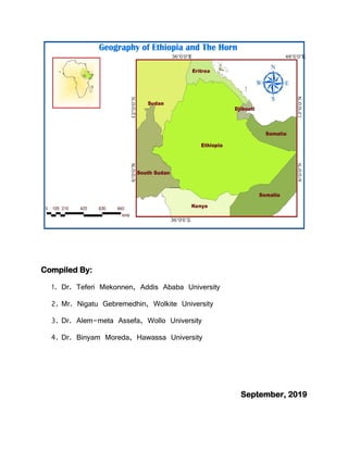
  • 10. 3 Human-Environment Interaction Humans have always been on ceaseless interaction with their natural environment. No other species that has lived on our planet has a profound effect on the environment as humans. Humans have adapted to the environment in ways that have allowed them to dominate all other species on Earth. Thus, human-environment interaction involves three distinct aspects: dependency, adaptation, and modification. Dependency refers to the ways in which humans are dependent on nature for a living. Adaptation relates to how humans modify themselves, their lifestyles and their behavior to live in a new environment with new challenges. Modification allowed humans to “conquer” the world for their comfortable living. Movement Movement entails to the translocation of human beings, their goods, and their ideas from one end of the planet to another. The physical movement of people allowed the human race to inhabit all the continents and islands of the world. Another aspect of movement is the transport of goods from one place on the Earth to another. The third dimension of movement is the flow of ideas that allows the unification of the human civilization and promotes its growth and prosperity. Region A region is a geographic area having distinctive characteristics that distinguishes itself from adjacent unit(s) of space. It could be a formal region that is characterized by homogeneity in terms of a certain phenomenon (soil, temperature, rainfall, or other cultural elements like language, religion, and economy). It can also be a functional or nodal region characterized by functional interrelationships in a spatial system defined by the linkages binding particular phenomena. 1.2. Location, Shape and Size of Ethiopia and the Horn The Horn of Africa, a region of eastern Africa, is a narrow tip that protrudes into the northern Indian Ocean, separating it from the Gulf of Aden. It is the easternmost extension of African land defined as the region that is home to the countries of Djibouti, Eritrea, Ethiopia, and Somalia, whose cultures have been linked throughout their long history. Although the countries of the region share many common features, there is also great diversity among them, rendering each country unique in many respects. In terms of size, Ethiopia is the largest of all the Horn of African countries, while Djibouti is the smallest.
  • 11. 4 The Horn contains such diverse areas as the highlands of the Ethiopian Plateau, the Ogaden desert, and the Eritrean and Somali coasts. Its coasts are washed by the Red Sea, the Gulf of Aden, and the Indian Ocean, and it has long been in contact with the Arabian Peninsula and southwestern Asia. 1.2.1. Location of Ethiopia The location of a country or a place on a map or a globe is expressed in two different ways. These are astronomical and relative locations (Figure 1.1). Astronomical location, also known as absolute or mathematical location, states location of places using the lines of latitudes and longitudes. Astronomically, Ethiopia is a landlocked country located between 3o N (Moyale) and 15o N (Bademe - the northernmost tip of Tigray) latitudes and 33o E (Akobo) to 48o E (the tip of Ogaden in the east) longitudes. The east west distance (150 ) is longer than the north-south distance (120 ). The latitudinal and longitudinal extensions are important in two ways. First, as a result of its latitudinal extension the country experiences tropical climate and secondly due to its longitudinal extension there is a difference of one hour between the most easterly and most westerly points of the country. It is only for convenience that the 3 hours-time zone is used in all parts of the country. Relative location expresses the location of countries or places with reference to the location of other countries (vicinal), landmasses or water bodies. The relative location of Ethiopia is indicated in Table 1.1. Table 1.1: The relative location of Ethiopia Vicinal location In relation to water bodies & land masses  Sudan to the west and northwest  South Sudan to southwest  Djibouti to the east  Somalia to the east and southeast  Eritrea to the north and northeast  In the Horn of Africa  Southwest of the Arabian Peninsula  South of Europe  Northwest of the Indian Ocean  In the Nile Basin
  • 12. 5  Kenya to the south The implications of the location of Ethiopia are described as follows: a) Climate: The fact that Ethiopia is located between 30 N and 150 N (between the Equator and Tropic of Cancer) implies that the country has a tropical climate, though modified by its altitude. The location of Ethiopia relative to the Indian Ocean, the Atlantic Ocean and the African and Asian landmass has also various bearings on the climate of Ethiopia. b) Socio-cultural: Ethiopia is one of the earliest recipients of the major world religions namely Christianity, Islam and Judaism due to its proximity to the Middle East, which was the origin of these religions. The linguistic and other cultural relationships, which Ethiopia shares with its neighbours, reflect the influence of location. c) Political: The political history of Ethiopia has been considerably influenced by:  Geopolitical considerations of superpowers.  Adjacency to the Red Sea (a major global trade route).  The Middle East geopolitical paradigms. As a result, Ethiopia has been exposed for external invasions in a number of times; though the country resisted foreign intervention and remains free of external domination.
  • 13. 6 Figure 1.1.Ethiopia‟s location in relation to its neighboring countries Source: Africa Map Library 1.2.2. Size of Ethiopia Ethiopia with a total area of approximately 1,106,000 square kilometers is the 8th largest country in Africa and 25th in the World. It extends about 1,639 kilometers East-West, and 1,577 kilometers North-South. About 0.7% of the country is covered by water bodies. The size of Ethiopia also affects both the natural and human environment of the country. The advantages and disadvantages of the size of Ethiopia are indicated in Table 1.2.
  • 14. 7 Table 1.2. Advantages and disadvantages of Ethiopia‟s large size Advantages Disadvantages Possess diverse agro ecological zones Demands greater capital to construct infrastructural facilities Variety of natural resources Requires large army to protect its territory Own extensive arable land Difficult for effective administration Have larger population size Difficult for socio-economic integration Home for diverse cultures Greater depth in defense external invasion 1.2.3. The shape of Ethiopia and its Implication Countries of the World have different kinds of shape that can be divided into five main categories: compact, fragmented, elongated, perforated, and protruded. These shapes have implications on defense, administration and economic integration within a country. Whether some kind of shape is advantageous to a country or not, however, depends on many other factors.  Compact shape countries: The distance from the geographic centre of the state to any of the borders does not vary greatly. It is easier for defence, socioeconomic and cultural integration.  Fragmented shape countries: They are divided from their other parts by either water, land or other countries.  Elongated shape countries: They are geographically long and relatively narrow like Chile.  Perforated shape countries: A country that completely surrounds another country like the Republic of South Africa.  Protrude shape countries: Countries that have one portion that is much more elongated than the rest of the country like Myanmar and Eritrea.
  • 15. 8 There are various ways of measuring shape of countries. These measures are known as the indices of compactness. These indices measure the deviation of the shape of a country from a circular shape, which is the most compact shape. Since there is no country with absolutely circular shape, those approximating a circular shape are said to be more compact. There are four most commonly used measures of compactness. These are: 1. The ratio of area of country to its boundary length: Area-Boundary ratio. The higher the A/B ratio, the greater the degree of compactness. 2. The ratio of boundary length of a country to the circumference of a circle having the same area as the country itself: Boundary-Circumference ratio. It measures how far the boundary of a country approximates the circumference of a circle of its own size. Therefore, the nearer the ratio to 1 the more compact the country is. 3. The ratio of the area of the country to the circumference of the smallest inscribing circle: Area-Circumference ratio. It compares the area of the country with the circumference of a circle that passes touching the extreme points on the boundary of the country. The higher the A/C ratio, the greater the degree of compactness. 4. The ratio of the actual area of a country to the smallest possible inscribing circle: Area- Area (A/A‟) ratio. The area of the inscribing circle is the area of the smallest possible circle whose circumference passes through the extreme points on the boundary. Half- length of the longest distance between two extreme points gives radius of the inscribing circle. The nearer the ratio to 1, the more compact the country is. Table 1.3: Ethiopia's shape compared to its neighbors in the Horn Country Area(km2 ) Boundary (km) A/B ratio B/C ratio A/C ratio Ethiopia 1,106,000 5,260 210.27 1.41 296.61 Djibouti 22,000 820 26.83 1.56 41.83 Eritrea 117,400 2,420 48.51 1.99 96.83 Kenya 582,644 3,600 161.85 1.33 215.28 Somalia 637,657 5,100 125.03 1.80 225.22 Source: Bekure (1982, 1983)
  • 16. 9 1.3. Basic Skills of Map Reading Activity 1.2 1. Define a map, 2. What is marginal information of a map? How important is it to read maps? 3. State the importance of a map. What is a Map? A map is a two-dimensional scaled representation of part or whole of the Earth surface on a flat body such as piece of paper, black board, wood or cloth. Map reading encompasses a systematic identification of natural features and manmade features. Natural features include mountains, plateaus, hills, valleys, river, ocean, rocks, plain etc. On the other hand, manmade features include roads, railway, buildings, dam etc. Although many disciplines use maps, they have a special significance for Geographers as primary tools for displaying and analyzing spatial distributions, patterns and relations. Since these features cannot easily be observed and interpreted in real landscapes, maps are essential to Geographers. Importance of maps  Provide the basis for making geographical details of regions represented i.e. the geographical facts of an area such as relief, drainage, settlement etc.  Maps are powerful tools for making spatial analysis of geographical facts of areas represented.  Maps are useful for giving location of geographical features by varied methods of grid reference, place naming etc.  Maps are used on various disciplines like land use planning, military science, aviation, tourism, marine science, population studies, epidemiology, geology, economics, history, archaeology, agriculture etc.  Map makes storage of the geographical data of areas represented.  Maps are potentially used to asses‟ reliable measurements of the geographical features. The measurements can be of area size, distance etc.
  • 17. 10 Types of Map There are many types of maps according to their purpose and functions. For the purpose of this course, topographical and statistical maps are considered. a. Topographical maps: Topographic maps depict one or more natural and cultural features of an area. They could be small, medium or large scale depending on the size of the area represented. Contents of topographical maps depend on purpose of a map, scale of a map, date of compilation, and nature of the land represented. b. Special purpose/statistical maps: These are maps, which show distribution of different aspects such as temperature, rainfall, settlement, vegetation etc. Marginal Information on Maps (Elements of Maps) Marginal information is shown on a map to enable the reading and interpretation of the geographical information of an area represented. This includes: a. Title: It is the heading of the given map which tells what the map is all about. b. Key (legend): It is the list of all convectional symbols and signs shown on the map with their interpretation. c. Scale: It is the ratio between the distance on the map and the actual ground distance. Scales enable the map user to interpret the ground measurement like road distance, areal sizes, gradient etc. It can be expressed as representative fraction, statements/verbal scale, and linear (graphic) scale. d. North arrow: It is indicated with the north direction on a map; used to know the other important directions of the mapped area like east, west, south, and west. e. Margin: Is the frame of the map. It is important for showing the end of the mapped area. f. Date of compilation: It is a date of map publication. This enables map users to realize whether the map is updated or outdated. Basic Principles of Map Reading In developing map reading abilities and skills, certain basic principles must be applied by the map-reader to translate map symbols into landscape images. Map Readers must have ideas about the symbol and also the real World (landscapes). Every map symbol must be visualized by the reader to read a map. The first symbols introduced should be those, which refer to landscape
  • 18. 11 features of which the reader already has some images. Map symbols should be introduced as needed. Secondly, knowledge of directions is an important principle in reading maps. One of the basic functions of maps is to help us to orient ourselves and to locate places on the earth. Unless a reader knows the basic directions, he or she may not use a map effectively. Before locating features using a map, north (the north arrow) should be determined and the readers should have practice in finding this direction. Next they should learn to read direction on a specific map and the location of the features shown on the map in relation to one another. Maps are covered in a series of lines that make up a grid. The lines have numbers accompanying them that allow you to accurately pinpoint your location on a map. Once you have located where you are, the grid system makes it simple to give an accurate description of your location. This description, which will be a series of numbers, is known as a grid reference. Review Questions Answer the following questions briefly. 1. What are the implications of location, shape and size of Ethiopia and the Horn on the physical environment, socioeconomic and political aspects? 2. Explain the themes of Geography. 3. What are the basic principles of map reading?
  • 19. 12 CHAPTER TWO THE GEOLOGY OF ETHIOPIA AND THE HORN 2.1. Introduction Geology is an Earth science that studies the evolution of the earth, the materials of which it is made of, and the processes acting upon them. Much of Geology is concerned with events that took place in the remote past when no one was around to witness them and with features which are far beneath the earth‟s surface where no one can see them. A great deal of geological understanding must, therefore, be obtained by inference, using clues from what can be seen and what can be measured. There are many such clues not only the rocks and landforms which can be observed and studied at the Earth‟s surface, but also those provided by indirect methods such as geophysics (e.g. studying earthquake waves which can penetrate deep beneath the Earth‟s surface), geochemistry (analysis of the detailed composition of rocks which can give clues as to their origin) and geochronology (methods for finding the ages of rocks, usually from the radioactive elements they contain). Therefore, this chapter will focus on the geology of Ethiopia and the Horn. In this chapter, you will study the geologic forces acting up on earth and their resulting land form, geological time scale and age dating techniques. Objectives After completing this chapter, the students will be able to:  Analyze the geologic processes and the resultant land forms of Ethiopia and the Horn.  Examine the formation of the Rift Valley.  Recognize the current status of Ethiopian mineral endowment associated with geologic processes. The earth‟s continents were once bunched up together in to a single huge continent called Pangaea. The large super continent was then split into Gondwanaland where Africa is a part and Laurasia; and later into smaller fragments over the last million years. These then drifted apart to form the present arrangement of continents. Australian Climatologist Alfred Wegener proposed the hypothesis that the continents were once assembled together as a supercontinent, called the Continental drift Theory.
  • 20. 13 Wegener‟s principal observations were:  Fit of the continents: The opposing coastlines of continents often fit together.  Match of mountain belts, rock types: If the continents are reassembled as Pangaea, mountains in West Africa, North America, Greenland, and Western Europe match up.  Distribution of fossils: The distribution of plants and animal fossils on separate continents forms definite linked patterns if the continents are reassembled.  Paleoclimates: rocks formed 200 million years ago in India, Australia, South America, and southern Africa all exhibited evidence of continental glaciations. 2.2. The Geologic Processes: Endogenic and Exogenic Forces Geology studies of how Earth's materials, structures, processes and organisms have changed over time. These processes are divided into two major groups: internal and external processes. The internal processes (endogenic) include volcanic activity and all the tectonic processes (folding, faulting, orogenesis (mountain building), and epeirogenesis (slow rising and sinking of the landmass). These processes result in building of structural and volcanic features like plateaus, rift valleys, Block Mountains, volcanic mountains, etc. The external (exogenic) processes are geomorphic processes. They include weathering, mass transfer, erosion and deposition. They act upon the volcanic and structural landforms by modifying, roughening and lowering them down. The landmass of Ethiopia, as elsewhere, is the result of the combined effect of endogenic and exogenic processes. The brief geological history of Ethiopia and the Horn will be dealt chronologically starting from the oldest Era of the Earth‟s history to the recent. 2.3. The Geological Time Scale and Age Dating Techniques The geological history is divided in to Eras. Each Era is divided into periods. The Eras are given names that indicate the kind of life that existed in them. For instance, the Paleozoic Era (ancient life) is the age of invertebrates, the Mesozoic Era (the middle life) is the age of reptiles while the Cenozoic Era (recent life) is the age of mammals. These geological time divisions basically differ from each other in such characteristics as the relative position of land and sea, the kind of climate and most important the kind of animal and plant life that developed and existed during that Era or period. Geological time is difficult to measure precisely.
  • 21. 14 The Earth is believed to have been formed approximately 4.5 billion years ago and the earliest forms of life were thought to have originated approximately 3.5 billion years ago. The first major boundary is defined by what was believed at the time to be the first appearance of life on earth. The span of time before life appeared was termed the Precambrian Era. To describe the geology and history of life on Earth, scientists have developed the geological time scale. The geological time scale measures time on a scale involving four main units: 1. An epoch is the smallest unit of time on the scale and encompasses a period of millions of years. 2. Chronologically, epochs are clumped together into larger units called periods. 3. Periods are combined to make subdivisions called Eras. 4. An eon is the largest period of geological time. The division of time units in the geological time scale is usually based on the occurrence of significant geological events (e.g. mass extinctions). As such, the geological time categories do not usually consist of a uniform length of time. The geological time scale, illustrated in Table 2.1, is built largely on the basis of life and evolution.
  • 22. 15 Table 2.1: The Geological time scale Era Period Began (in Million Years) End (my) Major Events (million years ago) Cenozoic Quaternary 1.6 Present Major glaciers in North America and Europe (1.5) Tertiary 70 1.6 Rocky Mountains (65), individual continents take shape. Mesozoic Cretaceous 146 70 Dinosaurs extinct (65), western interior seaway and marine reptiles (144 – 65) Jurassic 208 146 Pangaea (one land mass) begins to break up (200) Triassic 225 208 First mammals and dinosaurs Paleozoic Permian 290 225 Greatest extinction on Earth (245) Pennsylvani an 322 290 First reptiles Mississippia n 362 322 Coal-forming forests Devonian 408 362 First land animals and first forests (408) Silurian 439 408 Life invades land Ordovician 510 439 First fish appeared Cambria 600 510 Great diversity of marine invertebrates Precambrian Proterozoic 2,500 600 Marine fossil invertebrates (600) Archean 4,500 2,500 Earliest fossils recorded (3,500), earliest rock formation (4,000) Age Dating Techniques There are two techniques of knowing the age of rocks: Relative and absolute age dating.
  • 23. 16 A. Relative Dating Relative dating uses geological evidence to assign comparative ages of fossils. Hence, we can use two ways to know the relative age of a rock: one way is to look at any fossils the rock may contain. If any of the fossils are unique to one of the geologic time periods, then the rock was formed during that particular time period. The second way is to use the "What is on top of the older rocks?" When you find layers of rocks in a cliff or hillside, younger rocks are on top of older rocks. But these two methods only give the relative age of rocks -which one is younger and which is older. B. Absolute Dating Also known as Radiometric techniques. This technique was developed with discovery of radioactivity in 1896. The regular rates of decay for unstable, radioactive elements were found to constitute virtual “clocks” within the earth‟s rocks. Radioactive elements such as uranium (U) and thorium (Th) decay naturally to form different elements or isotopes of the same element. Every radioactive element has its own half-life. At the end of the period constituting one half-life, half of the original quantity of radioactive element has decayed; after another half-life, half of what was left is halved again, leaving one- fourth of the original, and so on. Two of the major techniques include: A. Carbon-14 Technique: Upon the organism‟s death, carbon-14 begins to disintegrate at a known rate, and no further replacement of carbon from atmospheric carbon dioxide can take place. Carbon-14 has half-life of 5730 years. B. Potassium-Argon Technique: The decay is widely used for dating rocks. Geologists are able to date entire rock samples in this way, because potassium-40 is abundant in micas, feldspars, and hornblendes. Leakage of argon is a problem if the rock has been exposed to temperatures above 125° C (257° F), because the age of the rock will then reflect the last episode of heating rather than the time of original rock formation.
  • 24. 17 2.4. Geological Processes and the Resulting Landforms of Ethiopia and the Horn Activity 2.1 1. Distinguish between endogenic and exogenic processes. 2. What are the major geological processes and the resulting landforms of Ethiopia and the Horn in each Era? 2.4.1. The Precambrian Era Geologic Processes (4.5 billion - 600 million years ago) The Precambrian Era covers 5/6th of the Earth‟s history. Due to its remoteness in time and the absence of well-preserved fossils, our knowledge of the events is limited. Nevertheless, some general description of the main geologic processes can be made. The major geologic event of the Precambrian Era was Orogenesis. As a result, the land was subjected to intense folding. This was accompanied by intrusive igneous activity. The result was the formation of huge mountain ranges. In between the orogenic periods and after the last orogenesis, there were long periods of denudation, which finally reduced these mountains to near-level (peneplained) rock surfaces. This “levelled” surface was later (in the Mesozoic and Cenozoic Eras) covered by younger rock formations. Therefore, in most parts of Ethiopia rocks belonging to this Era are found beneath all other rocks, forming the basement rocks. Since, they had been subjected to pressure and heat from overlying weight, earth movements (folding, orogenesis) and to intrusive igneous activity; the original rocks (both sedimentary and igneous) were altered into metamorphic rocks of varying stages of metamorphism. Since these same processes have allowed mineralization and crystal formation, the rocks are also collectively described as crystalline rocks.The Precambrian rocks are overlaid by recent rock formations. However, as surface rocks covering 25% of the land mass of the country; they are found exposed in the following areas: In the northern part: Western lowlands, parts of northern and central Tigray. A. In the western Part: Gambella, Benishangul-Gumuz (Metekel and Asossa), western Gojjam, western Wellega, Illuababora, and Abay gorge. B. In the southern Part: Guji, southern Omo, and parts of southern Bale and Borena. C. In the eastern part: Eastern Hararghe.
  • 25. 18 2.4.2. The Paleozoic Era Geologic Processes (600 million - 225 million years ago) The Paleozoic Era lasted for about 375 million years. The major geological process of this Era was denudation. The gigantic mountains that were formed by the Precambrian orogeny were subjected to intense and prolonged denudation. At the end, the once gigantic mountain ranges were reduced to a “peneplained” surface. Undulating plain with some residual features (inselbergs) here and there was formed. The sediments were transported southward and eastward to form continental (in Africa) and marine deposits, respectively. Because of the limited deposition within Ethiopia, rocks belonging to this Era are rare in the country. 2.4.3. The Mesozoic Era Geologic Processes (225-70 million years ago) This Mesozoic Era lasted for about 155 million years. It was an Era of alternate slows sinking and rising (epeirogenesis) of the landmass. This process affected the whole present-day Horn of Africa and Arabian landmass. At the same time the land was tilted eastward and therefore lower in the southeast and higher in the northwest. The subsidence of the land began about 225 million years ago. As the land sank slowly the sea invaded it starting from Somalia and Ogaden and slowly spreading northwestward. This was in late Triassic. This phenomenon continued up to Jurassic period. As the shallow sea spread towards the land, sands were deposited over the peneplained Precambrian rock surface. As the depth of the sea increased, mud (shale), gypsum and later lime were deposited. The latter is associated with the flourishing of marine life and decaying and precipitating of their remains, as the sea stayed long. Hence, Mesozoic rocks are considered to have the greatest potential for oil and gas deposits. Through time, compression by the overlying rocks and by cementing minerals, the sands and lime were compacted to form sandstone and limestone layers respectively. These are known as the Adigrat sand stone and Hintalo limestone layers. They are named after place names in Tigray where they might have been first identified. In the Horn of Africa and Ethiopia, the slow rise of the land and consequently the regression of the sea began in the Upper Jurassic. It continued throughout the Cretaceous period. With the retreat of the sea, another process of deposition occurred. In the country sedimentation ended with the deposition of clay, silt, sand conglomerate brought in from the land as the sea receded due to uplift of the landmass. Gypsum, shale and at last sands were laid over the Hintalo
  • 26. 19 limestone. The uppermost layer is known as the Upper sandstone. By the end of the Mesozoic Era, when the land emerged out of the sea, three major sedimentary formations were laid and formed upon the Precambrian rock surface. These were the Adigrat or lower sandstone, Hintalo limestone and Upper Sandstone. As transitional formations, gypsum and shale were inter- bedded above and below the Hintalo limestone. The Mesozoic sedimentary rocks cover 25% of the land mass of the country. Due to the tilting of the landmass during the transgression and regression of the sea, and due to the direction of the invading and retreating sea, the age and thickness of the Sandstone layers vary in a Southeast - Northwest direction. The Adigrat sandstone is older and thicker in the southeast and progressively decreases in age and thickness northwestward. The Upper sandstone, on the other hand, is thicker and younger (Upper Cretaceous) in the Southeast, while in the Northwest it is older and thinner. The transgressing sea and Mesozoic sediments nearly covered the whole of Ethiopia. The northwestern limit was as far as central Tigray, and western slopes of Western highlands. In most parts of Ethiopia, the Mesozoic rocks are overlaid by the Cenozoic rocks. As surface rocks, these old marine sediments are extensively found in the Southeast lowlands. Other exposures include central Tigray, and along the gorges of Abay and Wabishebelle rivers
  • 27. 20 Figure 2.1. Geological map of Ethiopia Source: CSA Shapefile, 2012 2.4.4. The Cenozoic Era Geologic Processes (70million years ago - Present) The Cenozoic Era is the most recent of the geologic Eras. The tectonic and volcanic activities that took place in this Era have an important effect in the making of the present-day landmass of Ethiopia and the Horn of Africa. The land was subjected to two major geologic events and other geologic processes of lesser magnitude but still important. These geologic activities are: a. Uplifting of the Arabo-Ethiopian landmass and outpouring of huge quantity of lava. b. Formation of the Rift Valley. c. Quaternary volcanism and deposition.  Uplifting of the Arabo-Ethiopian landmass and outpouring of lava flood The uplifting of the whole of the Arabo-Ethiopian landmass is a continuation of the slow rise that began in the Upper Jurassic and Cretaceous periods. This huge uplift continued to the Paleocene and Oligocene epoch of the Tertiary period. Where the uplifting was of greater magnitude, the land was pushed up to a maximum height of 2,000 meters above sea level. This occurred during the Eocene epoch. This uplifting was of an epeirogenic character. It was unparalleled anywhere else except in the Alpine orogenic belts of the Andes. The whole of the Arabo-Ethiopian landmass was pushed up in blocks as one mass. The greatest uplift was in central Ethiopia. This
  • 28. 21 immense tectonic force also fractured the crust at many places. Huge quantity of lava came out through these fractures. The out pouring of this flood of basalt spread widely and extensively and covered a large part of the Mesozoic sedimentary layer to form the Ethiopian plateau surface and also the floor of the present-day Rift Valley. At that time the Rift Valley was not yet formed. The mass of lava was so immense, that it formed a thick layer of volcanic rocks on the plateau, which mounted to more than 1,000 meters above sea level in the north Central Highlands. Where the lava comes out through vents, huge volcanic rocks were piled up to form many and huge Volcanic Mountains‟ towering the flat basaltic plateau. This volcanic material is known as Trappean lava or Trap Series lava. Where it is not dissected by erosion, the Ethiopian plateau had flat and nearly horizontal surface. This is an expression of the peneplaned Precambrian surfaces, the smothering effect of the Mesozoic deposition, and the spreading of the Trap series lava over the Mesozoic sediments.  The Formation of the Rift Valley The formation of the Rift Valley is said to be related with the theory of plate tectonics. According to the theory, the Rift Valley may be lying on the Earth‟s crust below which lateral movement of the crust in opposite directions producing tensional forces that caused parallel fractures or faults on the sides of the up-arched swell. As the tension widened the fractures, the central part of the landmass collapsed to form an extensive structural depression known as the Rift Valley (Fig. 2.2).
  • 29. 22 Figure 2.2.The Ethiopian and East African Rift Valley systems. Source: Africa Map Library The major faulting movement probably began in the late Oligocene and Miocene Epochs of the Cenozoic Era. This rifted the Red Sea trough, which began to be flooded from the north. But the major rifting, affecting the whole African Rift System, including that of Ethiopia and the Gulf of Aden took place in the Miocene Epoch. Rifting and faulting, however, continued all the time throughout the Pliocene and even the Pleistocene Epochs.
  • 30. 23 The Red Sea and the Gulf of Aden were connected as a result of the rifting and faulting of the land bridge that separated them. At the same period (Pliocene), the Afar depression (including the Gulf of Zula) was down-faulted allowing the Red Sea water to penetrate far inside. Reversed tilting and volcanic activity, later (Pleistocene) blocked the connection and isolated the extension of the sea, allowing much of the water to evaporate. As a result, thick saline materials accumulated. During the same period, the area between the Danakil Depression and the Red Sea was uplifted to form the Afar Block Mountains. The Spatial Extent of the Rift Valley The Ethiopian Rift Valley is part of the Great East African Rift system that extends from Palestine-Jordan in the north to Malawi-Mozambique in the south, for a distance of about 7,200 kilometers. Of these, 5,600 kilometers is in Africa, and 1,700 kilometers in Eritrea and Ethiopia. On land, the widest part of the Rift Valley is the Afar Triangle (200-300 km). The Red Sea, the Gulf of Aden, and the East African System meet and form the triangular depression of the Afar where the Kobar Sink lies about 125 meters below sea level. The formation of the Gulf of Aden and the separation of the Arabian Peninsula from the Horn of Africa also took place during the Tertiary period. The Rift Valley region of Ethiopian is the most unstable part of the country. There are numerous hot springs, fumorales, active volcanoes, geysers, and frequent earthquakes. The formation of the Rift Valley has the following structural (physiographic) effects:  It divides the Ethiopian Plateau into two.  It separates the Arabian landmass from African landmass.  It causes the formation of the Dead Sea, Red Sea and the Gulf of Aden troughs.  It creates basins and fault depressions on which the Rift Valley lakes are formed. Faulting and graben formation are not only limited to the Rift Valley. For example, similar tectonics activities have occurred in the Lake Tana Basin. However, the formation of Lake Tana had been accentuated by volcanic activity so that lava flow in the southeast had dammed part of the rim to deepen the basin. Faulting in other places had a structural control along some part of the river courses.  Quaternary Volcanic Eruptions and Depositions They are recent volcanic activities that took place after the formation of the Rift Valley. This occurred in the Pliocene-Pleistocene Epochs. This is a continuation of the tectonic and volcanic
  • 31. 24 processes that earlier affected the Rift Valley formation. It occurred in the form of renewed rifting/faulting and more volcanism. This activity was generally limited to the floor of the Rift Valley and the region south of Lake Tana, where the lava covers an area of more than 3,000km2 . Aden volcanics and recent faulting are more extensively developed in the Afar region. The area is shattered by numerous faults and subjected to extensive scoriaceous basalt eruptions. The latter phenomenon is also widely manifested in the main Ethiopian Rift, especially in its northern section. Some of the eruptions have occurred in the last few hundred years. Because of their recent occurrence, the Aden volcanics have relatively well-preserved and visible morphological features. The basic volcanic features of the Aden series include the following:  Numerous and freshly preserved volcanic cones, many of which have explosive craters. Some of these are active Dubi, Erta Ale, Afrera etc.Of these, Erta Ale is the most active volcano in Ethiopia.  Volcanic hills and mountains, some of which are semi-dormant (Fantale, Boseti-Gouda near Adama, Aletu north of Lake Ziway, Chebbi north of Lake Hawassa etc.).  Extensive lava fields and lava sheets some of which are very recent.  Lava ridges.  Thermal springs, fumaroles etc. Quaternary Deposition During the Quaternary period of the Cenozoic Era, the Earth experienced a marked climatic change, where warmer and dry periods were alternating with cooler and wet periods. This was the time of the last „‟Ice Age‟‟ in the middle and high latitude areas and the time of the „„Pluvial Rains‟‟ in Africa. The heavy Pluvial Rains eroded the Ethiopian plateau and the eroded materials were deposited in the Rift Valley lakes. The excessive rain resulted in an excessive surface flow; rivers were many and large. They carried a lot of water and sediments. Lake and marshy areas became numerous and deep. Many were enlarged and covered much area and even merged together. For example, Ziway-Langano- Shalla; Hawasa-Shallo; Chamo-Abaya; and Lake Abe and the nearby smaller lakes and marsh basins formed huge lakes. After the „„Pluvial Rains‟‟, the Earth‟s climate became warmer and drier. Thus, it increased the rate of evaporation that diminished the sizes of the lakes. Today, there are lacustrine deposits of
  • 32. 25 continental origin around many of the Ethiopian lakes, river valleys and lowlands. According to the place and manner of deposition and depositing agents these deposits are divided as follow. a. Lacustrine deposits: Deposits on former lakebeds, and swampy depressions. b. Fluvial deposits:Deposits on the banks of rivers, flood plains both in plateau, foothills etc. c. Glacio-fluvial deposits and erosional features: These are occurred on high mountains, such as Bale and Kaka Mountains. d. Aeolian deposits:Are windblown deposits. e. Coastal and marine deposits: Deposits on sea invaded and sea-covered places. The quaternary deposits are mainly found in the Rift Valley (Afar and Lakes Region), Baro lowlands, southern Borena, and parts of northwestern low lands. Generally, the Cenozoic rocks cover 50% of the land mass of the country. These include Highland Tertiary volcanics (basalts), Tertiary as well as Quaternary volcanics, and sediments of the rift valley. 2.5. Rock and Mineral Resources of Ethiopia The occurrence of metallic minerals in Ethiopia is associated with the Precambrian rocks. Although not in sufficient concentration and extent, a great variety of such minerals occur in the basement rocks. These rocks contain most of the metallic deposits known at present. The exploitation and search for mineral deposits in Ethiopia has been taking place for the past 2,000 years or so, and its early cultures were based partially on the mineral wealth of the day. Such has been the case of gold production and utilization, which has become part of Ethiopia‟s history, tradition and folklore. The mining and working of iron for the manufacture of tools, utensils and weapons, and the use of salt and salt-bar all these indicate to a fairly long mining tradition. However, presently mineral production from Ethiopia has been negligible by World standards. 2.5.1. Brief Facts and Current State of Main Minerals in Ethiopia Geological surveys proved that Ethiopia has abundant mineral resources of metals and precious metals, coal, and industrial minerals.
  • 33. 26 Gold Gold has been mined in Ethiopia for quite long time, mainly from Benishangul-Gumuz (Metekel) and Adola. Operating mines produce gold from primary sources in such localities as Dermi-dama, Sakoro and Lega-dembi. Mechanised alluvial working is confined to the state- operated gold field of Adola. Secondary gold deposits are common in the following localities: Adola, Murmur Basin, Shakiso, Awata Basin, Dawa Basin, Ghenale Basin, Ujama Basin,Makanisa (Guba and Wombera), Kaffa. In Gambella and Illuababora (Akobo River), in Sidama (Wondo), Borena (Negele-Yabelo area) and in Benishangul-Gumuz (Sherkole), west Wellega, Mengi-Tumat-Shangul areas to the Sudanese border, and the drainage of the Didessa and Birbir. Platinum The Yubdo area in Wellega, is the only active Ethiopian Platinum mine. Platinum occurrences have been reported from Delatti in Wellega, and the valley of Demi-Denissa and Bone Rivers as well as Tullu Mountain area in Sidama. Tantalum Significant deposit of tantalum and niobium is found in southern Ethiopia. It occurs in Adola area where Kenticha Tantalum mine with resources of more than 17,000 metric tons of world class ore reserve is found. The sedimentary and volcanic rock activities are also resourceful. Extensive lignite deposits in Ethiopia are found in Nedjo (Wellega), and in small amounts in Chilga (Gonder) are found in the sedimentary formations laid in between Trapean lava. However, important Lignite, one of the lowest ranked coal, is known to occur in many localities such as in the Beressa Valley and Ankober (North Shewa), Sululta (nearAddis Ababa),Muger Valley (West Shewa), Aletu valley (near Nedjo), Kariso and Selmi Valleys (Debrelibanos), Zega wodem gorge (near Fiche), Didessa Valley (southwest of Nekemte), Kindo and Challe Valley (Omo confluence), Adola,Wuchalle (north of Dessie), Chukga area (on Gonder-Metema road), Dessie area (near Borkena River). These areas are promise to be a good prospect to meet some of the local industrial and domestic needs. Gemstones Gemstones, including amethyst, aquamarine, emerald, garnet, opal, peridot, sapphire, and tourmaline occur in many parts of Ethiopia, mainly in Amhara and Oromia Regional States.
  • 34. 27 Quality Opal was first discovered by local people in Wadla and Dalanta woredas, North Wello in Amhara Regional State. Potash The potash reserve in the Danakil (Dallol Depression) of the Afar region is believed to be significant. Gypsum and Anhydrite A limited amount of gypsum is produced for domestic consumption in Ethiopia, mainly for the cement industry, but very large deposits are known to occur in sedimentary formations of the Red Sea coastal area, Danakil Depression, Ogaden, Shewa, Gojjam, Tigray, and Hararghe. Total reserves are probably enormous because the thickness of the gypsum deposits is many hundreds of meters and the formation are known to extend laterally for hundreds of kilometers. Clay Ethiopia is endowed with industrial clay material. Alluvial clay deposits for bricks and tile, pottery and pipe industry occur in Adola, Abay gorge, and the Rift Valley lakes region. Ceramic clay for the production of glasses, plates, bricks is found at Ambo and Adola. Tabor ceramic industry in Hawassa gets most of its raw materials from local sources. Marble Crystalline limestone is widespread in the basement rocks of Ethiopia. Marble has been quarried in such localities as west of Mekelle and south of Adwa in Tigray. In the east in Galetti, Soka, Ramis, Rochelle, Kumi and other valleys of Chercher Mountain in West Hararghe. In the northwestern also in areas built of Precambrian schist in Gonder, and the Dabus River and other neighboring river basins in Benishangul-Gumuz and Gojjam. Construction stones Basalt, granite, limestone and sandstone are important building stones. For the surfacing of roads and compaction, basalt, scoria and other volcanic rocks are extensively used. Mesozoic limestone is an important raw material for cement and chalk production. The earlier cement works at Dire Dawa and the recent ones at Muger Valley, Abay gorge (Dejen), Tigray (Messebo) are using similar raw materials from these rock formations.
  • 35. 28 2.5.2. Mineral Potential Sites of Ethiopia According to the Ethiopian geological survey, the geologic formations that host most mineral potentials of Ethiopia includes three major greenstone belts and other formations (Fig. 2.3). These are: 1. The Western and South-western-greenstone belt: They contain various minerals: primary gold occurrences (Dul,Tulu-Kape,Oda-Godere, Akobo,Baruda,Bekuji-Motish and Kalaj);Yubdo Platinum, Base metals of AzaliAkendeyu, Abetselo and Kata;Fakushu Molybdenite and the iron deposits of Bikilal, Chago, Gordana and Korre, Benshagul-Gumuz- Marble, Akobo and Asosa placer gold deposits and etc. 2. The Southern greenstone belt:It is known as the Adola belt, which comprises the primary gold deposits and occurrences of Lega-dembi, Sakaro, Wellena, Kumudu, Megado-Serdo, Dawa Digati, Moyale and Ababa River;the columbo-tantalite of kenticha and Meleka, andthe Adola nickel deposit and other industrial minerals. 3. The Northern greenstone belt(Tigray): This belt comprises of the primary gold occurrences of Terakemti, Adi-Zeresenay, and Nirague.The base metals of Terer, Tsehafiemba and other parts of Tigray, Placer gold occurrences of Tigray. Review Questions Answer the following questions briefly. 1. What were the major geologic processes of the Precambrian and Paleozoic Eras in the Horn of Africa? 2. Explain the formation of the oldest sedimentary rocks in Ethiopia and the Horn. 3. Discuss the major geologic events of Ethiopia that took place during the Cenozoic Era. 4. Where are the major mineral potential sites of Ethiopia? Discuss each of them with the help of examples.
  • 36. 29 CHAPTER THREE THE TOPOGRAPHY OF ETHIOPIA AND THE HORN 3.1. Introduction The topography of Ethiopia is largely determined by the geologic activities of the Cenozoic Era. The uplifting of the Arabo-Ethiopian swell and the subsequent outpouring, spreading and thick accumulation of Trapean lava have given rise to an outward sloping highland plateau and mountains. The major faulting resulted in the division of the plateau into two broad units and the formation of a great structural valley. Faulting elsewhere and on the floor guided part of the course of some rivers. They also formed depressions on which lakes were subsequently created. Geomorphic processes brought some modification to the structural landform by river dissection and roughening on the highlands, and deposition on the lower areas. Objectives At the end of this chapter, the learners will be able to:  Describe the topography of Ethiopia and the Horn.  Identify the physiographic divisions of Ethiopia.  Elucidate the physiographic characteristics of the Rift Valley.  Explain the impacts of relief on biophysical and socioeconomic conditions General Characteristics of the Ethiopian Physiography The Ethiopian landform is characterized by great diversity. There are flat-topped plateaus, high and rugged mountains, deep river gorges and vast plains. Altitude ranges from 125 meters below sea level (Kobar Sink) to the highest mountain in Ethiopia, Mount Ras Dashen (4,620 m.a.s.l), which is the fourth highest mountain in Africa. Ethiopia has the largest proportion of elevated landmass in the African continent. It is sometimes described as the Roof of East Africa because of its height and large area. More than 50% of the Ethiopian landmass is above 1,000 meters of elevation; and above 1,500 meters makes 44% of the country. Half of this, in turn, is at more than 2,000 meters above sea level. Most of the Ethiopian Highlands are part of central and northern Ethiopia, and its northernmost portion extends into Eritrea. The highland core, on the other hand, is encircled by semi-arid and lowlands. The Ethiopian Highlands are rugged mass of mountains, situated in the Horn of Africa. They are the most significant physical features of the country, which form the largest continuous area of its
  • 37. 30 elevation in the continent. They have been dissected by several rivers and ravines which have cut deep gorges. They have been divided into several regions and mountain systems. Most of the country consists of high plateau and mountain ranges that are sources of many rivers and streams that made the country to be described as the “Water Tower of East Africa”. The diversity in topography is accompanied by differences in other natural features such as soil, climate, vegetation and wild life. Likewise, the socio-cultural and economic phenomena are also affected by the topography. Taking the 1,000 meters contour line for the highland-lowland demarcation, one observes the following contrasting features between the Ethiopian highlands and lowlands:  Characteristics of Ethiopian highlands:  Moderate and high amount of rainfall (>600 mm per year).  Lower mean annual temperature (<200 C).  The climate is favourable for biotic life.  Rain-fed agriculture is possible.  Free from tropical diseases.  Attractive for human habitation and densely settled. The cumulative effect of all this is that, the highlands have been significant throughout Ethiopian history in the economic, cultural and political life of the people. These highlands make up nearly 56% of the area of the Ethiopia. This is further subdivided into lower highland (1,000 - 2,000 m.a.s.l), which make up 35% and higher highland (>2,000 m.a.s.l) constituting nearly 22%.  In contrast to the highlands, the remaining 44% of the Ethiopian lowlands are characterized by:  Fewer amounts of rainfall and higher temperature.  High prevalence of tropical diseases.  Lower population densities.  Nomadic and semi-nomadic economic life.  Vast plain lands favourable for irrigation agriculture along the lower river basins.
  • 38. 31 3.2. The Physiographic Divisions of Ethiopia What are the major physiographic divisions of Ethiopia? Can you explain the formation of Ethiopian rift valley? What biophysical characteristics can you mention about areas under rift in Ethiopia? Following the structural divisions brought about by the geologic processes of the Cenozoic Era, three major physiographic units can be identified in Ethiopia. These are: 1. The Western highlands and lowlands 2. The South-eastern (Eastern) highlands and lowlands 3. The Rift Valley 3.2.1. The Western Highlands and Lowlands This physiographic unit includes all the area west of the Rift Valley. It extends from north to south encompassing nearly the whole western half of Ethiopia. It makes up about 44% of the area of the country. In the east the western escarpment of the Rift Valley bound it whereas westward, the land gradually descends in altitude until it merges into the western foothills and lowlands, along the Sudan and South Sudan border. This region is further subdivided into four groups of highlands (76.3%) and four groups of lowlands (23.7%) (See Fig. 3.1). The Western Highlands a. The Tigray Plateau It extends from the Tekeze gorge in the south to central Eritrean highlands. The Tigray plateau is separated from the Eritrean plateau by the Mereb River. It lies to the southeast of the upper course of the Mereb/Gash River and to the northeast of Tekeze River Gorge. It constitutes about 13% of the area of the region. It is an elongated highland with most of the land being in between 1,000 and 2,000 meters above sea level. The right bank tributaries of Tekeze drain this plateau. Long period of denudation has created residual features of granite hills, rugged topography, and Ambas. There are high mountains in this plateau with elevations of over 3000 meters, namely Mount Tsibet (3988 m.a.s.l), Mount Ambalage (3291 m.a.s.l), and Mount Assimba (3248 m.a.s.l).
  • 39. 32 The famous monastery at Debre-Damo, a tableland that can only be climbed by a rope pulley is also located in this plateau region. Figure 3.1. Ethiopian Topography Source: CSA shapefile, 2012 b. North Central Massifs This Physiographic division is the largest in the western highlands. Much of its northern and southern limit follows the Abay and Tekeze gorges. The Abay, Tekeze and their tributaries have cut into this region a maze of gorges, steep sided river valleys, dividing the land into many isolated plateau blocks, precipitous tablelands and other rugged surface forms. But much of these plateau and tablelands are still capped by the Trappean lava. In its central part, the physiographic unit also accommodates the Lake Tana basin surrounded by plains of Fogera and Dembia in the north and an upland plain in its south. Fifty-eight percent of the region is at an altitude of more than 2,000 meters, making it, next to the Shewan Plateau, the second highest physiographic division. The region consists of the Gonder, Wello and Gojjam Massifs. Out of the 26 mountain peaks with altitude of more than 4,000m.a.s.l
  • 40. 33 in Ethiopia, 19 mountain peaks are found in this physiographic region. Among these, the most popular ones include Mount Ras Dashen (4,620 m.a.s.l), Mount Weynobar/Ancua (4462 m.a.s.l), Mount KidisYared (4453 m.a.s.l), and Mount Bwahit (4437 m.a.s.l) in the Simen Mountain System. Mount Guna (4,231m.a.s.l) in the Debre Tabour Mountain System, Abune Yoseph (4,260 m.a.s.l) in the Lasta highlands of Wello and Mount Birhan (4,154 m.a.s.l) in the Choke Mountain System in Gojjam are also part of Simen Mountain System. These mountains have steep cliffs and rugged terrain that provide scenic views to climbers The Mountain systems in Gonder and Gojjam are separated from the eastern group of mountains in Wello by impenetrable and deep gorges. At one point though, they are connected by Yeju- Wadla Delanta land bridge (ridge). This land bridge has been significant in history. It served as a route of penetration by the Turks, Portuguese, and Italians etc. The Woreta-Debre Tabor-Woldya road constructed to link the northwestern region with Asseb through Woldya and Dessie took advantage of this land bridge. c. The Shewa Plateau/central highlands The Shewan plateau is bounded by the Rift Valley in the east and southeast, by the Abay gorge in its northern and western limit, and the Omo gorge in the south and west. This plateau occupies a central geographical position in Ethiopia. With only 11% of the area of the whole physiographic region, the Shewa Plateau is the smallest of the Western highlands. Nearly three- fourth of its area is at an altitude of more than 2,000 meters above sea level. It has, therefore, the largest proportion of elevated ground. The Shewa plateau is drained, outward in all directions by the tributaries of Abay, Omo, and Awash. It, therefore, forms a water divide for these three river basins. The tributaries of Abay- Guder, Muger, Jema etc. have cut deep gorges and steep sided river valleys. They have created several tablelands and isolated plateau units in the north. Similarly, the tributaries of Omo and Awash have dissected the other sides of the plateau. Otherwise, this plateau has relatively extensive flat-topped uplands, giving it the appearance of a true plateau. The highest mountain in the Shewan plateau is Mount Abuye-Meda (4,000 m.a.s.l) in Northern Shewa, Mount Guraghe in the south is 3,721 meters high.
  • 41. 34 d. The Southwestern Highlands This Physiographic subdivision consists of the highlands of Wellega, Illuababora, Jimma, Kaffa, Gamo and Gofa. This region is separated from the adjacent highlands by the Abay and Omo river valleys. It extends from the Abay gorge in the north to the Kenya border and Chew Bahir in the south. It accounts for 22.7% of the area of the region. The region is the second largest in the Western highlands. About 70% of its area is lies within 1,000-2,000 meters altitude. The southwestern plateau is the wettest in Ethiopia. It is drained by Dabus, Deddessa (tributaries of Abay), Baro, Akobo and the Ghibe/Omo rivers. The numerous streams have cut these highlands to produce the most dissected and rugged terrain that accommodates the most numerous and diverse ethnic linguistic groups in Ethiopia. With a height of 4,200 meters above sea level, Guge Mountain is the highest peak in this physiographic subdivision. The Western Lowlands These are the western foothills and border plains that extend from Western Tigray in the north to southern Gamo-Gofa in the South. In certain places, ridges or part of the highlands protrude into the lowlands, interrupting their continuity. They make 11% of the area of the physiographic region. The general elevation ranges between 500 and 1000 meters above sea level. This physiographic sub-region is further subdivided into four by the protruding ridges. These are Tekeze lowland, Abay-Dinder lowland, Baro lowland, and Ghibe lowland from north to south. With the exception of the Baro lowland, the region is generally characterized by arid or semi-arid conditions. Pastoral or semi-pastoral economic activities dominate the area. As one moves northwards, the degree of aridity increases, making rain-fed agriculture more difficult. Since one or two rivers cross all of these lowlands, irrigation agriculture is highly feasible. For example, the Baro lowland has an extensive flat area suitable for mechanized agriculture. The Ghibe/Omo lowland, which includes the lower Ghibe/Omo Valley and the northern section of the Turkana basin, is classified in the Western lowlands from its geographical location. But structurally it also belongs to the Rift Valley. It is an area, which is both faulted and tectonically depressed.
  • 42. 35 In the Western lowlands, there are small but important towns. Their importance could be related to agriculture, history, or are simply border towns and frontier ports. These are Humera, Metema, Omedla, Kurmuk, Gambella etc. 3.2.2. The Southeastern Highlands and Lowlands This physiographic region is the second largest in terms of area. It accounts for 37% of the area of Ethiopia. The highlands make up 46% of the physiographic division while the rest is lowland. In the west and north, the eastern escarpment of the Rift Valley makes the western and northern limit. In many places the land raises so abruptly that from the edge of the plateau one literally looks down the Rift Valley. From here, the land gradually descends southeastward into the southeastern lowlands and then to the plains of Somalia. These are further subdivided into two units of highlands and two units of extensive lowlands. These are briefly discussed as follows. The Southeastern Highlands A. The Arsi-Bale-Sidama Highlands These highlands are found to the east of the Lakes Region. They are located in the south western section of the physiographic region. They make up 28.5% of the area of the region and 62% of the south - Eastern Highlands. The Arsi Highlands are made up of flat rolling uplands and dissected mountains. The well- known mountains in this area are Mount Kaka (4,180 m.a.s.l), Mount Bada (4,139 m.a.s.l) and Mount Chilalo (4,036 m.a.s.l). The Bale highlands are separated from the Arsi highlands by the head and main stream of Wabishebelle. They consist of a platform looking basaltic plateau in the north-central part and high mountain massif to the south. The Afro-Alpine summit of Senetti plateau is found on the latter group. The highest mountain peaks in this region are Tulu-Demtu (4,377 m.a.s.l) and Mount Batu (4,307 m.a.s.l). Erosion features belonging to Pleistocene glaciation but later modified by fluvial processes are seen in the trough-like gorges, hanging valleys, and depressions. The Arsi-Bale Highlands are important grains producing areas with still high potential.
  • 43. 36 The Sidama Highlands are separated from the Bale Highlands by the Ghenale river valley. They occupy the southwestern corner of this region. The prominent feature here is the Jemjem plateau, an important coffee growing area. Rivers Wabishebelle and Ghenale along with their tributaries have dissected this physiographic region. Specially, Weyb River, tributary of Ghenale, has cut an underground passage (Sof Omar cave) through the Mesozoic Limestone rocks. The cave is found near Bale Mountains. It is one of the World's most spectacular and extensive underground caverns creating a magnificent view accessible only by an underground stream. B. The Hararghe Plateau This plateau is a north-easterly extension of the south-eastern highlands. It extends from the Chercher highlands in the south-west to Jigjiga in the east. It makes up 38% of the South Eastern highlands and 17.4% of the whole physiographic region. It has the smallest proportion of upper highland (>2,000 meters). It is a low lying and elongated region. Rising sharply from the Rift Valley floor, it immediately but gently descends east and southeastward. The left-bank tributaries of Wabishebelle drain it. Much of the Trappean lava is removed and the Mesozoic rocks are extensively exposed. The highest mountain here is Mount Gara-Muleta (3,381 m.a.s.l). The Southeastern Lowlands The Southeastern lowlands are located in the southeastern part of the country and they are the most extensive lowlands in Ethiopia. They make up 54% of the area of the physiographic region and around one-fifth of the country. This region is divided into Wabishebelle plain (60%) and the Ghenale Plain (40%). They include the plains of Ogaden, Elkere, and Borena. Southeastward sloping plains characterize these lowlands. These extensive plains are interrupted here and there, by low hills, low ridges, inselbergs and by shallow and broad river valleys and depressions. Because of the harsh climatic conditions, these lowlands are little used and support very small population. They are sparsely inhabited by pastoral and semi-pastoral communities. The economic potential for this region includes animal husbandry, irrigation, agriculture and perhaps exploitation of petroleum and natural gas.
  • 44. 37 3.2.3. The Rift Valley The Rift Valley is a tectonically formed structural depression. It is bounded by two major and more or less parallel escarpments. The formation of the Rift Valley has separated the Ethiopian Highlands and Lowlands in to two. It extends from the Afar triangle in the north to Chew Bahir for about 1,700 km2 . It covers 18% of the area of Ethiopia. It is elongated and funnel shaped, with a NE-SW orientation. It opens out in the Afar Triangle, where it is the widest, and narrows down to the south. The floor of the Rift Valley is made up of interconnected troughs, grabens and depressions. Volcanic rocks, fluvial and lacustrine deposits cover the floor. In many places, numerous volcanic domes, hills and cinder cones rise from the floor. Altitude in the floor ranges from 125 meters below sea level at Dallol Depression, to as high as 2,000 meters above sea level in the Lakes region. The bounding escarpments are also of varying heights. From the floor to the edge of the escarpment, the heights vary from 200 to 1500 meters. Because of its altitudinal variation and positional differences, the climate also varies from warm, hot and dry to cool and moderately moist conditions. Similarly, the social and economic life reflects this pattern. There are places, which are desolate and sparsely inhabited by pastoralists where as in others parts people practice some rain-fed agriculture. The Rift Valley is further subdivided into three physiographic sub-regions. These are the Afar Triangle, the Main Ethiopian Rift, and the Chew Bahir Rift. A brief description of each sub- division is given below. i. The Afar Triangle The Afar Triangle is the largest and widest part of the Rift Valley. It makes up 54% of the Rift Valley area. It is bounded by the high western and eastern escarpments in the west and east respectively, and by the Afar and Aisha Horst in the northeast. The area is generally of low altitude (300-700 meters). Quite different is the morphology of the Afar depression, triangular-shape lowland, where elevation drops uniformly from approximately 1,000 meters in the southwest to below sea level in the north (Danakil depression) and in the east, where the shores of Lake Asal, fluctuating at around 125 meters below sea level, represent the lowest subaerial point of the African continent.
  • 45. 38 The depression, which hosts one of the most hostile environments on Earth (maximum temperatures can exceed 50°C during the summer wet season; Dallol, at the northern tip of Afar. The area is characterized by faulted depressions (grabens), volcanic hills, active volcanoes, volcanic ridges, lava fields and low lava platforms. Lakes (Abe, Asale, and Afrera) occupy some of these basins. A prominent feature in this region is the Denakil Depression (Kobar Sink). Separated from the Red Sea by a 200 meters high land barrier, much of it lies below sea level. A larger part of this is covered by thick and extensive salt plain. Lake Asale and Lake Afreraoccupy the lowest parts of this sunken depression. The Afar Triangle is generally hot and dry. The only respite one gets in the Southern part is from the waters of the Awash River. The economic importance of this region includes salt extraction, irrigation along the Awash River and electric potential from geothermal energy. ii. The Main Ethiopian Rift/Central Rift It refers to the narrow belt of the Rift Valley that extends from Awash River in the north to Lake Chamo in the south. It is bounded by the western and eastern escarpments. With the exception of the Arbaminch area, the bounding escarpments are generally low. This part of the Rift Valley is the narrowest and the highest. It has an average width of 50-80 kilometers and general elevation of 1,000-2,000 meters above sea level. The floor in many places is dotted by cinder cones and volcanic mountains. The big ones include Mount Fentale, Boseti-guda (near Adama), Aletu (north of Lake Ziway) and Chebi (north of Lake Hawasa). The northern section has more of these cinder cones and lava fields. The prominent features, however, are the numerous lakes formed on tectonic sags and fault depressions. Because of altitude, the lakes region of the Main Ethiopian Rift is generally milder and watery. Here rain-fed agriculture is practiced. Other resource bases include the recreational value of the lakes, the agricultural importance of some streams and lakes, and the geothermal energy potential. iii. The Chew Bahir Rift This is the smallest and the southern-most part of the Rift Valley. Gneissic highlands of Konso and the surrounding highlands separate it from the Main Ethiopian Rift to the north. The
  • 46. 39 characteristic feature of this region is the broad and shallow depression, which is a marshy area covered by tall grass, into which the Segen and Woito streams empty. 3.3. The Impacts of Relief on Biophysical and Socioeconomic Conditions The highly dissected character of the landscape over much of the country‟s territory along with the limited extent to which flat surfaces are present influence the various socioeconomic aspects of Ethiopia as presented hereunder. 1. Agricultural practices Relief influences farm size and shape in that in an area of rugged terrain the farmlands are small in size and fragmented and tend to be irregular in shape.  Choice of farming techniques and farm implements are highly influenced by relief as in rugged terrain mechanized farming techniques are difficult to practice.  Relief influences crop production as some corps are well adapted to higher altitudes (barley, wheat) and others to low altitude (sorghum, maize).  The practice of animal husbandry is also influenced by relief as most equines and sheep are reared in the higher altitudes and camels and goat are well adapted to lower altitudes 2. Settlement pattern  Highlands of Ethiopia that experience a temperate type of climatic condition that are mainly free from most of the tropical diseases are densely settled.  Rugged and difficult terrain hinders the development of settlement and its expansion.  The highlands of Ethiopia are characterized by sedentary life and permanent settlements while lowlands that are inhabited by pastoralists have temporary settlements. 3. Transportation and communication  The highly dissected nature of the landscape is a barrier to the development of internal surface transportation that resulted in the long-term isolation of many communities  The difficult terrain makes infrastructure development and maintenance costly.  TV and radio communications are also highly influenced by relief.  The rugged topography rendered rivers less navigable due to the waterfalls, deep gorges and steep cliffs. 4. Hydroelectric power potential  The great difference in altitude coupled with high rainfall created suitable conditions for a very high potential for the production of hydroelectric power in Ethiopia.
  • 47. 40 5. Socio-cultural feeling  The rugged terrain as a result of excessive surface dissection resulted in the long-term isolation of communities that led to the occurrence of cultural diversity.  People who live in the highlands have been identifying themselves as degegnas (mountaineers) and those who live in the lowlands as kollegnas (lowlanders). 6. Impacts on climate  The climate of Ethiopia is a result of the tropical position of the country and the great altitudinal variation of the general topography.  Highlands with higher amount of rainfall and lower rate of evapo-transpiration tend to be moisture surplus compared to the moisture deficit lowlands. 7. Impacts on soil  Steep mountain slopes provide low angle of rest, unstable surface materials and subject to degradation processes and relatively form shallow and little developed soils. 8. Impacts on natural vegetation  Relief through its effect on climate and hydrology affect the type of natural vegetation grown in an area. Review Questions Answer the following questions briefly. 1. What are the impacts of relief on the biophysical and socioeconomic conditions of Ethiopia? 2. Discuss the physiographic characteristics of the southeastern highlands and lowlands.
  • 48. 41 CHAPTER FOUR DRAINAGE SYSTEMS AND WATER RESOURCE OF ETHIOPIA AND THE HORN 4.1. Introduction About 71% of the earth‟s total surface is covered by water bodies majorly occupied by seas and oceans. Of the earth‟s total water surface, nearly 97.5% is alkaline accumulated in seas and oceans. The remaining 2.5% is fresh water, of which nearly 68.7% is deposited in glaciers, 30.1% in ground water, 0.8% in permafrost and 0.4% in surface waters. Water in lakes, rivers, atmosphere, soils and wetlands are considered as surface waters. Surface and ground waters are by far the most abundant and easily available fresh waters. However, fresh water is distributed unevenly throughout the world following varied latitudinal locations, climatic and topographic setups. As you have discussed in the third chapter, the topographic setup of Ethiopia is characterized by complex blend of massive highlands, rugged terrain, and low plains. The diverse topographical setup, relatively higher rainfall and its nearness to equator made the country to have larger volume of ground and surface water. Around 0.7 % of the total land mass of Ethiopia is covered by water bodies. Although it requires further detailed investigation, the country‟s surface water potential as studied in different integrated river basin master plans is estimated to be 124.4 billion cubic meters (BCM). Consequently, many call Ethiopia, the water tower of “Eastern Africa”. Objectives At the end of this chapter you will be able to:  Describe the major drainage systems in Ethiopia and the Horn,  Examine the surface and ground water resource potentials of Ethiopia,  Understand economic potentials of the water sector in Ethiopia. 4.2. Major Drainage System of Ethiopia How do you conceptualize drainage system? The flow of water through well-defined channel is known as drainage. A drainage system is made up of a principal river and its tributaries (the rivers that flow into it). A river system begins
  • 49. 42 at a place called the source or headwater and ends at a point called mouth. Therefore, a drainage system is branched network of stream channels together with the adjacent land slopes they drain. The drainage pattern of an area is the outcome of the geological processes, nature and structure of rocks, topography, slope, amount and the periodicity of the flow. A drainage basin is the topographic region from which a river and its tributaries collect both the surface runoff and subsurface flow. It is bounded by and separated from other river basins by a water divide or topographic divide. The general patterns of major river basins in Ethiopia are determined by topographical structures which can be clarified as: a. The topography of the outward sloping of the Western and South eastern plateaus b. The structural formation of the Rift Valley with its in-ward-sloping escarpments resulting mainly in an inland drainage system. c. Faults and joints that structurally influence part of the courses of many rivers. The Major Drainage Systems Why do rivers rise from higher slope and flow towards the lower? Following the complex physiographic setup and geological makeup, Ethiopia possesses three broadly classified drainage systems namely Western, Southeastern and Rift ValleyDrainage Systems. Western and the Southeastern drainage systems are separated by the Rift Valley system. 4.2.1. The Western Drainage Systems The Western Drainage Systems are the largest of all drainage systems draining 40 percent of the total area of the country and carry 60 percent of the annual water flow. Most of the catchment area coextends with the westward sloping part of the western highlands and western lowlands. This drainage system comprises four major river basins namely the Tekeze, Abay, Baro-Akobo, Ghibe (Omo). Unlike other river basins in the system, the Ghibe (Omo) flows southward. The Abay, Tekeze and Baro flow westward ultimately joining the Nile which finally ends at Mediterranean Sea. The largest river both in volumetric discharge and coverage in the western drainage systems is the Abay (Table 4.1). Abay river basin covers an area of 199,812 km2 , covering parts of Amhara, Oromia and Benishangul-Gumuz regional states. Together with its tributaries, most of which are
  • 50. 43 left-bank tributaries; it carries 65 percent of the annual water flow of the region. Abay which rises from Lake Tana (some sources indicate its origin from Sekela, Choke mountain) flows about 1,450 kilometres and joins the White Nile in Khartoum, Sudan to form the Nile River. More than 60 streams drain the Abay within elevation ranging between 500 - 4261 meters above sea level. The largest of these is Ghilgel Abay (Little Abay). Abay flows eastward, turns 180 to make a large bend and after cutting an impressive and deep gorge emerges out in the west. Similarly, the Tekeze and its tributaries, carrying 12 percent of the annual water flow of the region drains 82,350 Km2 of land surface within elevation ranging between 536-4517 meters above sea level. Erosion in the basin resulted in large tablelands, plateau blocks and isolated mountain groups. The basin has two main tributaries (Angereb and Goang) which rises in the central highlands of Ethiopia. Tekeze River is termed Atbara in Sudan, which is a tributary of the Nile. The total mean annual flow from the basin is estimated to be 8.2 billion metric cubes (BMC, here after). The Baro-Akobo and Ghibe / Omo rivers drain the wettest highlands in the south and southwestern Ethiopia. They carry 17 percent and 6 percent of the annual water flow respectively. The Ghibe/ Omo river basin drains an area of 79,000 km2 with an estimated mean annual flow of 16.6 BMC. In the lower course, the Baro River flows across an extensive marshy land. Baro Akobo river basin has an area of 75,912 km2 , covering parts of the Benishangul- Gumuz, Gambella, Oromia, and SNNPR. The total mean annual flow from the river basin is estimated to be 23.6 BMC. The Baro together with Akobo forms the Sobat River in South Sudan. The Ghibe / Omo River finally empties in to the Chew-Bahir at the mouth of Lake Turkana (an elongated Rift Valley lake) thereby forming an inland drainage. 4.2.2. The Southeastern Drainage Systems Nearly the entire physiographic region of southeastern part of Ethiopia is drained by the southeastern drainage systems. The basin which is mainly drained by Wabishebelle and Ghenale, slopes south-eastwards across large water deficient plains. Major highlands of this basin include plateaus of Arsi, Bale, Sidama and Harerghe. Wabshebelle and Ghenale rivers cross the border into Somalia, carrying 25 percent of the annual water flow of Ethiopia. Ghenale River basin has an area of 171,042 km2 , covering parts of Oromia, SNNPR, and Somali regions. Ghenale, which has fewer tributaries but carries more water than Wabishebelle, reaches
  • 51. 44 the Indian Ocean. The basin flows estimated to be 5.8 BMC within elevation ranging between 171-4385 meters above sea level. In Somalia it is named the Juba River. Wabishebelle with a total catchment area of 202,697 km2 , is the largest river in terms catchment area. It drains parts of Oromia, Harari and the Somali regions. It is the longest river in Ethiopia. Its tributaries are mainly left bank and, most of them, are intermittent. Despite its size, the Wabishebelle fails to reach the Indian Ocean where at the end of its journey it flows parallel to the coast before its water disappears in the sands, just near the Juba River. Figure 4.1. Drainage Basins of Ethiopia Source: CSA shapefile, 2012 4.2.3. The Rift Valley Drainage System The Rift Valley drainage system is an area of small amount of rainfall, high evaporation and small catchment area. The size of the drainage area is restricted by the outward sloping highlands, which starts right from the edge of the escarpment. The Rift Valley drainage system is therefore left with the slopes of the escarpment and the Rift Valley floor itself as the catchment area.