SlideShare a Scribd company logo
1 of 8
Agroecological Zones of Bangladesh &their Soil Conditions
Fig:AgroecologicalZonesof Bangladesh
Agroecological Zone landareasrecognisedon the basisof hydrology,PHYSIOGRAPHY,soil
types,tidal activity,croppingpatterns, SEASONS.Infactan agroecological zone indicatesan
area characterisedbyhomogeneous agricultural andecological characteristics.This
homogeneityismore prominentinthe subregion andunitlevels.The agroecologicalzones
of Bangladeshhave beenidentifiedonthe basisof fourelementssuchasphysiography,
SOILS, land levelsinrelationtofloodingand agroclimatology.Bangladesh hasbeen
tentatively dividedinto30 agroecological zones.These 30zoneshave beensubdividedinto
88 agroecological sub-regions,whichhave been furthersubdividedinto535 agroecological
units.Physiographyformsthe primaryelementin defininganddelineatingthe agroecological
regionsinBangladesh.Soilsformthe second elementindefininganddifferentiating
agroecological zonesassoil conditions determine importantpropertiesforplantgrowth,
moisture supply,rootaerationandnutrient supply.The thirdfactorislandlevel inrelation
to flooding.Inthisregardthe countryhas been classifiedintofourtypesof landlevel suchas
highland(landwhichisabove normal flood-level),mediumhighland(landwhichnormallyis
floodeduptoabout90 cm deepduringthe FLOODseason),mediumlowland(landwhich
normallyisfloodeduptobetween90cm and 180 cm deepduringthe floodseason),lowland
(landwhichnormallyisfloodeduptobetween 180 cm and 300 cm deepduringthe flood
season),verylowland(landwhichnormallyis floodeddeeperthan300 cm duringthe flood
season).Anadditional class,bottomland,is recognisedfordepressionsitesinanylandlevel
classwhichremainswetthroughoutthe year.The depthlimitsbetweenthe depthof
floodingclassesare notrigid.Floodlevelsinanarea may vary by as muchas a metre or
more between differentyears.Theymayalsoreachtheirpeak levelsforonlyafew daysat a
time duringa particularyear.These classesactuallyindicate the level of flooding which
farmersexpectwhen theydecidewhichCROPStogrow inthe kharif seasonontheir
differentkindsof land,basedon theirlongexperience of cultivationonparticular sites.
Highland may be suitable for kharif or perennial DRYLAND crops if the soils are permeable.
Impermeable soils or soils which can be made impermeable by PUDDLING may be suitable for
transplanted aus and/or aman paddy if bunds are made to retain rainwater on fields. Medium
highland is suitable for crops which can tolerate shallow flooding, such as broadcast or transplanted
aus paddy, JUTE and transplanted aman paddy. Early kharif dryland crops which mature before
flooding starts can be grown on permeable soils, and late kharif and early rabi dryland crops on soils
which drain in September-October. Medium lowland is flooded too deeply for transplanted aus or
transplanted aman paddy to be grown reliably. Mixed broadcast aus and deepwater aman is a
common practice; or long aman seedlings may be transplanted as the floodwater recedes. Dryland
rabi crops are widely grown on soils which drain in October or November. Lowland is flooded too
deeply for broadcast aus or transplanted aman to be grown.Deepwater aman is typically grown on
such land, although the cultivation of irrigated boro paddy on such land in the dry season now
precludes the cultivation of deepwater aman over considerable areas of lowland. Dryland rabi crops
can only be grown if flood water recedes before December. Very low land generally is too deeply
flooded for even deepwater aman to be grown.Bottomland stays too wet for paddy to be sown
broadcast. The traditional crop on such land is local boro paddy, either not irrigated or irrigated by
traditional low-lift IRRIGATION devices. In a few other areas where flooding normally does not
exceed 1.5m, very long aman paddy seedlings are transplanted early in the MONSOON season.The
fourth element considered in identifying agroecological zones in Bangladesh comprises the four
climatic zones of the country. The combined agroclimatic zones could be superimposed on the zones
and sub-regions to create unique agroecological units. The Agroecological Zones (AEZ) database is
unique and is being extensively used for national and local level production planning purposes.The
agroecological resources are increasingly playing an important role in agricultural planning,
technology transfer and specific bio-physical resource utilisation programme activities. The database
on AEZ, however, needs updating as over time there have been some changes in the land types
because of roads and other structural measures, variability in precipitation and TEMPERATURE as
well as innovation of modern crop cultivation which could survive under different environmental
stressconditions. A brief descriptionof 30 AEZ regionsisgivenbelow:
Zones/Regions Sub Regions
1. Old HimalayanPiedmontPlain a) North-central;b)Northern; c) Southern
2. Active TistaFloodplain Active TistaFloodplain
3. Tista MeanderFloodplain a) Central;b) Eastern;c) LowerAtrai Floodplain;d) Lower
Little JamunaFloodplain;e) North-easternandSouthernNorth-western;f)UpperLittleJamuna and
Middle Atrai Floodplain
4. Karatoya-Bangali
Floodplain a) NorthernandCentral;b) South-western
5. Lower Atrai Basin LowerAtrai Basin
6. Lower Punarbhaba
Floodplain LowerPunarbhabaFloodplain
7. Active Brahmaputra-JamunaFloodplain Active Brahmaputra-JamunaFloodplain
8. Young Brahmaputraand JamunaFloodplain a) High JamunaFloodplain;b)Upper
BrahmaputraFloodplain;c) UpperBrahmaputra-JamunaFloodplain
9. Old Brahmaputra
Floodplain a) Bansi Valley;b) High;c) Low; d)MediumHigh;e)MediumLow
10. Active Ganges
Floodplain Active Ganges Floodplain
11. HighGanges River
Floodplain a) Central and Southern;b) Ganges- MahanandaFloodplain;c)Northern
12. Low Ganges River
Floodplain a) Central;b) Eastern
13. GangesTidal
Floodplain a) KhulnaSundarban;b) Nonsaline,calcareous;c)Nonsaline,
calcareousand non calcareous;d)Nonsaline, noncalcareous;e) Saline,AcidSulphate Soils;f) Saline,
calcareousand noncalcareous;g) Saline,noncalcareous
14. Gopalganj-KhulnaBeels Beel centres
15. Arial Beel Arial Beel
16. Middle MeghnaRiver
Floodplain Middle MeghnaRiver Floodplain
17. LowerMeghna River
Floodplain a) Calcareous,flood protected;b) Calcareous,unembanked;c)
Noncalcareous,floodprotected;d)Noncalcareous, unembanked
18. YoungMeghna Estuarine
Floodplain a) Nonsaline:Central Bhola;b) Nonsaline:MeghnaEstuaryCharland;c)
Nonsaline:North Bhola;d) Saline:Central Bhola;e) Saline:Noakhali,HatiyaandMeghnaEstuary;f)
Saline:SandwipandSouth Bhola
19. OldMeghna Estuarine
Floodplain a) Dhaka-Narayanganj- DemraProjectArea;b)High:OldMeghna Estuarine
Floodplain;c) Low:Daudkandi-Habiganj;d) Low:Dhaka- Shariatpur- Barisal;e) Low:Eastern
Kishoreganj;f) Low:Gopalganj Beels margins;g) Low:Habiganj-NorthBrahmanbaria;h) Low: Titas
Floodplain;i) MediumLow;j) Very poorlydrained: Laksham-Begumganj
20. EasternSurma-Kushiyara
Floodplain Eastern Surma-KushiyaraFloodplain
21. SylhetBasin a)Central andSouthern; b) Northern;c)Western
22. NorthernandEasternPiedmontPlain a) Northernand EasternBasins;b)
NorthernandEastern PlainsandBasins;c)North-westernPlains andBasins;d) South Sylhet
PiedmontPlains
23. ChittagongCoastal Plain a) BeachRidges, Mangrove Swampand Mud Clay;b) Mangrove
Tidal Floodplain;c) PiedmontPlainsand RiverFloodplains; d)YoungTidal Floodplain
24. St Martin’s Coral Island St. Martin’sCoral Island
25. Level Barind Tract a) Highland andMediumHighland;b)MediumLowlandand Lowland
26. HighBarind Tract HighBarindTract
27. North-easternBarindTract a) Mainlypoorly drained;b) Mainlywell drained;c) Mixedwell
drainedandpoorly drained
28. MadhupurTract a) Mainlypoorly drainedlevel terrace; b) Mainlywelldrained
dissectedterrace 29. Northernand EasternHills a) Low hillsand PiedmontPlains;b) Mainlyhighhill
ranges;c) Mainlylowhills
30. AkhauraTerrace AkhauraTerrace
DESCRIPTION OF AGROECOLOGICALZONES OF BANGLADESH:
1.Old Himalayan PiedmontPlain(4,008 sqkm) this distinctive regionisdevelopedinanoldTista
alluvial fanextendingfromthe footof the HIMALAYAS.It has a complex relief pattern.Deep,rapidly
permeable sandyloamsandsandy clayloamsare predominantinthis region.They are strongly
acidicin TOPSOILandmoderately acidicinSUBSOILS; low inweatherable K minerals.Sevengeneral
soil typesoccurin the region,of whichnon-calcareousbrownfloodplain soils,blackterai soils,and
non-calcareousdark greyfloodplainsoilspredominate.Organicmatter contentsare generallyhigher
than inmost FLOODPLAIN soilsof Bangladesh.The natural fertilityof the soil ismoderate butwell
sustained.Soil fertilityproblemsinclude rapid leachingof N,K,S,Ca, Mg and B. Most of
PANCHAGARHandTHAKURGAON districtsand the northwesternpartof DINAJPURdistrictare
includedinthiszone.
2.Active Tista Floodplain(830 sqkm) thisregion includesthe active floodplainsof the TISTA ,
DHARLA andDUDHKUMAR rivers.It hascomplex patternsof low,generallysmoothridges,inter-
ridge depressions,riverchannelsandcut-off channels.The areahasirregularpatternsof grey
stratifiedSANDSandSILTS.Theyare moderately acidicthroughoutandparentalluviumismedium in
weatherable Kminerals.Fourgeneral soil typesoccurinthe region,andof them, non-calcareous
alluviumpredominates.OrganicmattercontentsandSOILFERTILITY level are low tomedium.
3.Tista MeanderFloodplain (9,468 sq km) this regionoccupiesthe majorpart of the Tistafloodplain
as well asthe floodplainof the ATRAI,LITTLEJAMUNA , KARATOYA ,Dharla and Dudhkumarrivers.
Most areas have broad floodplainridgesandalmostlevelbasins.There isanoverall patternof olive
brown,rapidly permeable,loamysoilsonthe floodplainridges, andgreyordark grey,slowly
permeable,heavy siltloamorsiltyclayloamsoilsonthe lower landandPARENTMATERIALS
mediumin weatherable Kminerals.Eightgeneral soil types occurinthe region,moderatelyacidic
throughout, lowinorganicmattercontenton the higherland, butmoderate inthe lowerparts.
Fertilitylevelis lowtomedium.Soils,ingeneral,have good moisture holdingcapacity.
4.Karatoya-Bangali Floodplain(2,577 sq km) this regionisverysimilartothe Tista Meander
Floodplaininphysiographyandsoil,and comprisesamixture of Tistaand BRAHMAPUTRA
sediments.Mostareashave smooth,broad,floodplainridgesandalmost level basins.The soilsare
greysiltloamsand siltyclayloamsonridgesandgrey or dark grey claysin basins.Five generalsoil
typesoccur in the region,of whichnon-calcareousgrey floodplainandnon-calcareousdarkgrey
floodplainsoilspredominate.The soil is moderatelyacidicthroughout.Organicmattercontentsare
generallylowinthe cultivatedlayerof ridge soils andmoderate inbasins.Generalfertilityis
medium.The easternhalf of BOGRA andmost of SIRAJGANJdistrictsare includedin thiszone.
5.Lower Atrai Basin (851 sq km) thisregion comprisesthe low lyingareabetweenthe BARIND
TRACT and the Gangesriverfloodplain.Itincludesthe CHALAN BEELarea. Dark grey, heavy,acidic
claysare predominate inthis smoothlow-lyingbasinland.Sevengeneralsoil typesoccurin the
region.Organicmatter,andstatus of otheressential nutrientsare medium, while level of available K
(potassium) ishigh.Fertilitystatusof soilsismoderate.
6.Lower Punarbhaba Floodplain (129 sq km) this small regionoccupiesbasinsandBEELSseparated
by lowfloodplainridges.Inthisarea, darkgrey,mottled red,verystronglyacid,heavyCLAYSoccupy
bothridge and basinsites.Organicmatterstatusismediumtohigh.General fertilitylevel ismedium
withhighK-bearingminerals.The westernpartof NAOGAON andthe northern partof NAWABGANJ
districtsare includedinthisAEZ.
7.Active Brahmaputra-Jamuna Floodplain(3,190 sqkm) thisregion comprisesthe beltof unstable
alluvial landalongthe Brahmaputra-Jamunarivers where landis constantlybeingformedand
erodedbyshiftingriverchannels.Ithasan irregularreliefof broadandnarrow ridgesand
depressions.The areaisoccupiedbysandyand siltyalluvium, rich inweatherable Kmineralsthatare
slightlyalkalineinreaction.Six general soil typesoccupythe area.Organicmatterstatus is low and
fertilitystatusislowtomedium.
8.Young Brahmaputra and Jamuna Floodplain (5,924 sq km) the regioncomprisesthe areaof
Brahmaputrasediments.Ithasa complex relief of broadandnarrow ridges,inter-ridge depressions,
partiallyinfilledcut-offchannels andbasin.Thisareaisoccupiedbypermeablesiltloamtosiltyclay
loamsoilsonthe ridges and impermeable claysinthe basins,neutral to slightlyacidinreaction.
General soil types includepredominantlygreyfloodplainsoils. Organicmattercontentislow in
ridgesand moderate inbasins.Soilsare deficientinN,P, andS but the statusof K and Znare
reasonable.
9.Old Brahmaputra Floodplain (7,230 sq km) this regionoccupies alarge area of Brahmaputra
sedimentsbefore the rivershiftedtoitspresent JAMUNA channel about200 yearsago.The region
has broadridgesand basins.Relief is irregular,especially nearthe oldandpresentriver channels.
Soilsof the area are predominantlysiltloamstosiltyclayloamsonthe ridgesand clayin the basins.
Organicmatter contentislowon the ridgesandmoderate inthe basins,topsoils moderately acidic
but subsoilsneutral in reaction.General fertilitylevel islow.
10.Active GangesFloodplain (3,334 sqkm) this regionoccupiesunstablealluviallandwithinand
adjoiningGANGESriver.Ithasirregularrelief of broadandnarrow ridgesand depressions
interrupted bycut-off channelsandactive channels.The areahascomplex mixturesof calcareous
sandy, siltyand clayeyalluvium.The general soiltypes,predominantlyinclude, calcareous,alluvium
and calcareousbrown floodplainsoils. Soilsare low inorganicmatterand mildlyalkaline inreaction.
General fertility levelismediumbutdeficientinN.
11.High GangesRiverFloodplain(13,205 sq km) thisregionincludesthe westernpartof the Ganges
riverfloodplainwhichispredominantly highlandandmediumhighland.Mostareashave a complex
relief of broadandnarrow ridgesand inter-ridge depressions.The upperpartsof highridgesstand
above normal floodlevel.Lower partsof ridgesandbasinmarginsare seasonally shallowlyflooded.
General soil types predominantlyinclude calcareousdarkgrey floodplainsoilsandcalcareousbrown
floodplainsoils.Organicmattercontentinthe brownridge soilsis low buthigherinthe dark grey
soils.Soilsare slightlyalkalineinreaction.Generalfertilitylevelislow.
12.Lower GangesRiverFloodplain (7,968 sq km) the regioncomprisesthe easternhalf of the
Gangesriverfloodplainwhichislow-lying.The areahasa typical meanderfloodplainlandscape of
broad ridgesandbasins.Soilsof thisregion are siltloamsand siltyclayloamsonthe ridges and silty
clay loamto heavyclaysonlowersites.General soiltypes predominantlyinclude calcareous dark
greyand calcareousbrown floodplainsoils.Organicmattercontentislow in ridgesand moderate in
the basins.General fertilitylevel ismedium.
13.Ganges Tidal Floodplain(17,066 sqkm) this regionoccupiesanextensiveareaof tidal floodplain
landin the southwestof the country. The greaterpart of thisregionhas smoothrelief havinglarge
areas of salinity.Riverbanks generallystand aboutametre or lessabove the level of adjoining
basins.Non-calcareousgrey floodplainsoil is the majorcomponentof general soil types.ACID
SULPHATE SOIL alsooccupiesa significantpartof the area,where itisextremely acidicduringthe
dry season.Mostof the topsoilsare acidicandsubsoilsare neutral to mildlyalkaline.Soilsof the
SUNDARBANSareaare alkaline.General fertilitylevel ishigh,withmediumtohighorganicmatter
content.
14.Gopalganj-KhulnaBeels(2,247 sqkm) the regionoccupiesextensivelow-lyingareasbetweenthe
Gangesriverfloodplainandthe Gangestidal floodplain.Soilsof the areaare grey,and dark grey,
acidic,heavyclaysoverlay PEATor muckat 25-100 cm. General soil typesinclude mainlypeatand
non-calcareousdark greyfloodplainsoils.Organicmattercontentis mediumtohigh.Fertility level is
medium.
15.Arial Beel (144 km) thisregionoccupiesalow-lyingbasinbetweenthe Gangesanddhaleshwari
riversinthe southof the formergreaterDHAKA district.Ithas much incommonwiththe lower Atrai
Basinand the Gopalganj-KhulnaBeels.The soilsof thisareaare dark grey,acidicheavy clays.Non-
calcareousdark greyfloodplainsoil isthe chief general soil type.Organicmattercontentgenerally
exceedstwopercentinthe top subsoil.Available moisture holdingcapacityis inherentlylow.
General fertilitylevelismediumto high.
16.Middle Meghna RiverFloodplain (1,555 sq km) thisregionoccupiesanabandonedchannel of the
Brahmaputrariveron the borderbetweenthe greaterDhakaandCOMILLA districts.The region
includesareasof oldBrahmaputrachars within the MEGHNA riveras well asadjoiningpartsof the
mainland.Soilsof the areaare grey loamon the ridgesand greyto dark greyclays inthe basins.The
dominantgeneral soil type isnon- calcareousgreyfloodplainsoil.Topsoilsare stronglyacidicand
subsoilsslightlyacidicto slightlyalkaline.General fertilitylevel ismedium withlow N andorganic
matter.
17.Lower MeghnaRiver Floodplain (909 sq km) this area occupiesthe transitional areabetweenthe
middle Meghnariverfloodplainandthe young Meghnaestuarine floodplain.Soilsof thisarea are
relativelyuniform,siltloamsoccupyrelatively higherareas andsiltyclayloamsoccupythe
depressions.Non-calcareousdarkgreyfloodplain andcalcareousgreyfloodplainsoils are major
componentsof general soil types.Topsoilsare moderatelyacidicandsubsoilsneutral in reaction.
General fertilitylevelismediumtohigh withlow tomediumorganicmatterstatusandK- bearing
minerals.
18.Young Meghna Estuarine Floodplain (9,269 sq km) thisregion occupiesyoungalluvial landin and
adjoiningthe Meghnaestuary.The majorsoilsare greyto olive,deepcalcareoussiltloam andsilty
clay loams,andare stratifiedeitherthroughoutorat shallow depth.Calcareous alluviumandnon
calcareousgreyfloodplainsoils are the dominantgeneral soil types.Topsoilsandsubsoilsof the area
are mildlyalkaline. General fertilityismediumbutlow inN and organicmatter.
19.Old Meghna Estuarine Floodplain (7,740 sq km) thisregionoccupies alarge area, mainlylow-
lyingland betweenthe southof the Surma-Kushiyarafloodplainandthe northernedge of the young
Meghna estuarine floodplain.Siltloam soilspredominateonhighlandsandsiltyclayto clayon
lowlands.Organicmattercontentof the soilsare moderate.Topsoilsare moderatelyacidic,but
subsoilsneutral inreaction.General fertilitylevel ismedium.
20.Eastern Surma-Kushiyara Floodplain(4,622 sq km) thisregion occupiesthe relativelyhigherparts
of the Surma-KushiyarafloodplainformedonSEDIMENTS of the riversdrainingintothe Meghna
catchmentarea fromthe hills.Thisaream isoccupiedby grey,heavysiltyclayloamson the ridges
and claysinthe basins.Organicmattercontentof the soil ismoderate.Soil reactionranges from
stronglyacidicto neutral.
21.Sylhet Basin (4,573 sq km) the regionoccupies the lower,westernside of the Surma-Kushiyara
floodplain.Reliefis locallyirregularnearrivers.Soilsof the areaare greysiltyclayloamsand clay
loamon the higherpartsthat dry out seasonallyandgreyclaysinthe wetbasins.The soilshave a
moderate contentof organicmatterand soil reactionis mainlyacidic.Fertilitylevel ismediumto
high.
22.Northern and WesternPiedmontPlains (4,038 sq km) thisisa discontinuousregionoccurringas
a narrow stripof landat the footof the northern and easternhills.The regioncomprisesmerging
alluvial fanswhichslopegentlyoutwardfromthe footof the northernand easternhillsinto smooth,
low-lyingbasins.Greypiedmontsoils andnon-calcareousgreyfloodplainsoilsare the majorgeneral
soil typesof the area.Soilsof the area are loamsto clays,slightlyacidictostronglyacidicinreaction.
General fertilitylevelislowtomedium.
23.Chittagong Coastal Plain (3,720 sq km) thisregionoccupiesthe plainlandingreater
CHITTAGONGdistrictand the easternpart of FENI district.Itisa compoundunitof piedmont, river,
tidal andestuarine floodplainlandscapes. The majorproblem inthese soilsishighsalinity duringthe
dry season(OctobertoMay).Grey silt loamsand siltyclayloamsoilsare predominant. Acidsulphate
floodplains.Generalfertilitylevelof the soilsis medium,butN and K are limiting.Organicmatter
contentislowto moderate.
24.St Martin'sIsland (8 sq km) thissmall but distinctive regionoccupiesthe whole of ST MARTIN'S
ISLANDinthe extreme southof the country.The areahas verygentlyundulatingold beachridges
and inter-ridgedepressions, surroundedbysandybeaches.The soilsare developed entirelyonold
and youngCORALbeach sands. Calcareousalluviumisthe only general soil type of the area.General
fertility level islowwithpoormoisture holdingcapacity.
25.Level Barind Tract (8 sq km) thisregionis developedoverMADHUPURCLAY . The landscape is
almostlevel.The predominantsoils have agrey,silty,puddledtopsoil with ploughpan.Shallow grey
terrace soil and deep greyterrace soilsare the majorcomponentsof general soil typesof the area.
The soilsare low inavailable moisture holdingcapacityand slightlyacidictoacidicinreaction.
Organicmatter statusisverylowand most of the available nutrientsare limiting.
26.High Barind Tract (16 sq km) itincludesthe southwesternpartof the BarindTract where the
underlyingMadhupurClayhadbeenupliftedand cutintoby deepvalleys.The soilsinclude puddled
siltloamto siltyclayloaminthe topsoilsandporous siltwithmottledplasticclayatvaryingdepth.
Deepgreyterrace soilsandgrey valleysoilsare majorcomponentsof the general soil typesof the
area.General fertilitystatusis low,havinglow statusof organicmatter.
27.North Eastern Barind Tract (1,079 sqkm) this regionoccupies several discontinuousareasonthe
north-easternmarginsof the Barind Tract.It has siltyor loamy topsoil andclayloamsto claysubsoil.
The soilsare stronglyacidicinreaction. Organicmatterinthe soilsislow.General fertilityispoor.
28.Madhupur Tract (4,244 sq km) thisisa regionof complex relief andsoils developedoverthe
Madhupur Clay.The landscape compriseslevelupland,closelyorbroadlydissectedTERRACES
associatedwitheithershallow orbroad,deep valleys.Eleven generalsoil typesexistinthe areaof
whichdeepredbrownterrace,shallow redbrownterrace soilsandACIDBASIN CLAYS are the major
ones.Soilsinthe valleysare dark greyheavyclays.Theyare stronglyacidicin reactionwithlow
statusof organicmatter,low moisture holdingcapacityandlow fertilitylevel.
29.Northern and Eastern Hills(18,171 sq km) this regionincludesthe country'shill areas.Reliefis
complex.Hillshave beendissectedtodifferent degreesoverdifferentrocks.Ingeneral,slopesare
verysteepandfewlowhillshave flat summits.BROWN HILLSOILS isthe predominantgeneral soil
type of the area.Organic mattercontentandgeneral fertilitylevel are low.
30.Akhaura Terrace (113 sqkm) this small region occupiesthe easternborderof BRAHMANBARIA
and the southwestcornerof HABIGANJdistrict. The mainsoilsinthe uplandshave strongbrown
clay.The valley soilsrange fromsiltyclayto clays.Deepredbrownterrace soils,grey piedmontsoils
and acidbasinclays are the majorcomponentsof the general soil typesof the area.The general
fertilityincludingorganicmatterstatus islow.The soilsare strongly acidicinreaction.
(Source:BibliographyFAO/UNDP,LandResources Appraisal of BangladeshforAgricultural
DevelopmentReport2:Agroecological Regions of Bangladesh,FAO/UNDP,1988; BangladeshBureau
of Statistics,1998 Yearbookof Agricultural Statistics,BBS,Dhaka,1999.)

More Related Content

What's hot

Application of Remote Sensing in Agriculture
Application of Remote Sensing in AgricultureApplication of Remote Sensing in Agriculture
Application of Remote Sensing in AgricultureUTTAM KUMAR
 
GIS application in Natural Resource Management
GIS application in Natural Resource ManagementGIS application in Natural Resource Management
GIS application in Natural Resource ManagementAchal Gupta
 
GIS and agriculture
GIS and agricultureGIS and agriculture
GIS and agricultureMOHTISHIM CH
 
Agro-Ecological Regions of India
Agro-Ecological Regions of IndiaAgro-Ecological Regions of India
Agro-Ecological Regions of IndiaCalcutta University
 
Soil Survey, Soil Mapping and Soil Status in Nepal by Y.G. Khadka
Soil Survey, Soil Mapping and Soil Status in Nepal by Y.G. KhadkaSoil Survey, Soil Mapping and Soil Status in Nepal by Y.G. Khadka
Soil Survey, Soil Mapping and Soil Status in Nepal by Y.G. KhadkaFAO
 
Soil survey the quest for precision agriculture in bangladesh
Soil survey the quest for precision agriculture in bangladeshSoil survey the quest for precision agriculture in bangladesh
Soil survey the quest for precision agriculture in bangladeshDr. Md. Altaf Hossain
 
DETERMINANTS OF AGRICULTURE (INSTITUTIONAL AND TECHNOLOGICAL FACTOR)
DETERMINANTS OF AGRICULTURE (INSTITUTIONAL AND TECHNOLOGICAL FACTOR)DETERMINANTS OF AGRICULTURE (INSTITUTIONAL AND TECHNOLOGICAL FACTOR)
DETERMINANTS OF AGRICULTURE (INSTITUTIONAL AND TECHNOLOGICAL FACTOR)Calcutta University
 
Land Capability Classification
Land Capability ClassificationLand Capability Classification
Land Capability ClassificationRisikesh Thakur
 
Land Suitability Classification
Land Suitability ClassificationLand Suitability Classification
Land Suitability ClassificationRisikesh Thakur
 
02 agro.ecological zones of pakistan
02 agro.ecological zones of pakistan02 agro.ecological zones of pakistan
02 agro.ecological zones of pakistanSaeedIZON
 
Digital image processing and interpretation
Digital image processing and interpretationDigital image processing and interpretation
Digital image processing and interpretationP.K. Mani
 
Remote sensing application in agriculture & forestry_Dr Menon A R R (The Kera...
Remote sensing application in agriculture & forestry_Dr Menon A R R (The Kera...Remote sensing application in agriculture & forestry_Dr Menon A R R (The Kera...
Remote sensing application in agriculture & forestry_Dr Menon A R R (The Kera...India Water Portal
 
Soil mapping , remote sensing and use of sensors in precision farming
Soil mapping , remote sensing and use of  sensors in precision farmingSoil mapping , remote sensing and use of  sensors in precision farming
Soil mapping , remote sensing and use of sensors in precision farmingDr. M. Kumaresan Hort.
 
LAND CAPABILITY CLASSIFICATION
LAND CAPABILITY CLASSIFICATIONLAND CAPABILITY CLASSIFICATION
LAND CAPABILITY CLASSIFICATIONdebaaaaaaaa
 
ICAR - National Bureau of Soil Survey and Land Use Planning
 ICAR - National Bureau of Soil Survey and Land Use Planning ICAR - National Bureau of Soil Survey and Land Use Planning
ICAR - National Bureau of Soil Survey and Land Use PlanningExternalEvents
 

What's hot (20)

Application of Remote Sensing in Agriculture
Application of Remote Sensing in AgricultureApplication of Remote Sensing in Agriculture
Application of Remote Sensing in Agriculture
 
GIS application in Natural Resource Management
GIS application in Natural Resource ManagementGIS application in Natural Resource Management
GIS application in Natural Resource Management
 
Capability classification of Land
Capability classification of LandCapability classification of Land
Capability classification of Land
 
Soil classification
Soil classificationSoil classification
Soil classification
 
GIS and agriculture
GIS and agricultureGIS and agriculture
GIS and agriculture
 
Agro-Ecological Regions of India
Agro-Ecological Regions of IndiaAgro-Ecological Regions of India
Agro-Ecological Regions of India
 
Soil Survey, Soil Mapping and Soil Status in Nepal by Y.G. Khadka
Soil Survey, Soil Mapping and Soil Status in Nepal by Y.G. KhadkaSoil Survey, Soil Mapping and Soil Status in Nepal by Y.G. Khadka
Soil Survey, Soil Mapping and Soil Status in Nepal by Y.G. Khadka
 
Soil survey the quest for precision agriculture in bangladesh
Soil survey the quest for precision agriculture in bangladeshSoil survey the quest for precision agriculture in bangladesh
Soil survey the quest for precision agriculture in bangladesh
 
DETERMINANTS OF AGRICULTURE (INSTITUTIONAL AND TECHNOLOGICAL FACTOR)
DETERMINANTS OF AGRICULTURE (INSTITUTIONAL AND TECHNOLOGICAL FACTOR)DETERMINANTS OF AGRICULTURE (INSTITUTIONAL AND TECHNOLOGICAL FACTOR)
DETERMINANTS OF AGRICULTURE (INSTITUTIONAL AND TECHNOLOGICAL FACTOR)
 
Land Capability Classification
Land Capability ClassificationLand Capability Classification
Land Capability Classification
 
Drought indices
Drought indicesDrought indices
Drought indices
 
Land Suitability Classification
Land Suitability ClassificationLand Suitability Classification
Land Suitability Classification
 
02 agro.ecological zones of pakistan
02 agro.ecological zones of pakistan02 agro.ecological zones of pakistan
02 agro.ecological zones of pakistan
 
Digital image processing and interpretation
Digital image processing and interpretationDigital image processing and interpretation
Digital image processing and interpretation
 
Remote sensing application in agriculture & forestry_Dr Menon A R R (The Kera...
Remote sensing application in agriculture & forestry_Dr Menon A R R (The Kera...Remote sensing application in agriculture & forestry_Dr Menon A R R (The Kera...
Remote sensing application in agriculture & forestry_Dr Menon A R R (The Kera...
 
Land USE AND SURVEYING
Land USE AND SURVEYINGLand USE AND SURVEYING
Land USE AND SURVEYING
 
Soil mapping , remote sensing and use of sensors in precision farming
Soil mapping , remote sensing and use of  sensors in precision farmingSoil mapping , remote sensing and use of  sensors in precision farming
Soil mapping , remote sensing and use of sensors in precision farming
 
Soil survey and land use
Soil survey and land useSoil survey and land use
Soil survey and land use
 
LAND CAPABILITY CLASSIFICATION
LAND CAPABILITY CLASSIFICATIONLAND CAPABILITY CLASSIFICATION
LAND CAPABILITY CLASSIFICATION
 
ICAR - National Bureau of Soil Survey and Land Use Planning
 ICAR - National Bureau of Soil Survey and Land Use Planning ICAR - National Bureau of Soil Survey and Land Use Planning
ICAR - National Bureau of Soil Survey and Land Use Planning
 

Similar to agro Ecological zone [AEZ} of bangladesh

Pakistan’s soil resources
Pakistan’s soil resourcesPakistan’s soil resources
Pakistan’s soil resourcesSajid Sarwar
 
Ground water fluctuations in Northwestern Bangladesh (Over last 30 years) Imp...
Ground water fluctuations in Northwestern Bangladesh (Over last 30 years) Imp...Ground water fluctuations in Northwestern Bangladesh (Over last 30 years) Imp...
Ground water fluctuations in Northwestern Bangladesh (Over last 30 years) Imp...Mozakkir Azad
 
DESERT PLANNING
DESERT PLANNINGDESERT PLANNING
DESERT PLANNINGshnwz c
 
Determination of shallow groundwater aquifer geometry using geo electrical te...
Determination of shallow groundwater aquifer geometry using geo electrical te...Determination of shallow groundwater aquifer geometry using geo electrical te...
Determination of shallow groundwater aquifer geometry using geo electrical te...Alexander Decker
 
Hydrogeology of-the-dry-zone-central-myanmar-summary
Hydrogeology of-the-dry-zone-central-myanmar-summaryHydrogeology of-the-dry-zone-central-myanmar-summary
Hydrogeology of-the-dry-zone-central-myanmar-summaryMYO AUNG Myanmar
 
Prospects and challenges in development of ground water resources of bangladesh
Prospects and challenges in development of ground water resources of bangladesh Prospects and challenges in development of ground water resources of bangladesh
Prospects and challenges in development of ground water resources of bangladesh Jahangir Alam
 
Welcome to International Journal of Engineering Research and Development (IJERD)
Welcome to International Journal of Engineering Research and Development (IJERD)Welcome to International Journal of Engineering Research and Development (IJERD)
Welcome to International Journal of Engineering Research and Development (IJERD)IJERD Editor
 
Sudan SUDAN: NAPA PROJECT PROFILE
Sudan SUDAN: NAPA PROJECT PROFILESudan SUDAN: NAPA PROJECT PROFILE
Sudan SUDAN: NAPA PROJECT PROFILEelodieperrat
 
wetland id hard copy
wetland id hard copywetland id hard copy
wetland id hard copyJesse Jones
 
Climate Action in the southwestern part of Bangladesh ppt- Akib Hossain Mehed...
Climate Action in the southwestern part of Bangladesh ppt- Akib Hossain Mehed...Climate Action in the southwestern part of Bangladesh ppt- Akib Hossain Mehed...
Climate Action in the southwestern part of Bangladesh ppt- Akib Hossain Mehed...AkibMehedi
 
Watershed charecteristics
Watershed charecteristicsWatershed charecteristics
Watershed charecteristicsVipin Mishra
 
How to conserve biodiversity in range land in country A presentation By Mr Al...
How to conserve biodiversity in range land in country A presentation By Mr Al...How to conserve biodiversity in range land in country A presentation By Mr Al...
How to conserve biodiversity in range land in country A presentation By Mr Al...Mr.Allah Dad Khan
 
How to conserve biodiversity in range land in country A Presentation By Mr Al...
How to conserve biodiversity in range land in country A Presentation By Mr Al...How to conserve biodiversity in range land in country A Presentation By Mr Al...
How to conserve biodiversity in range land in country A Presentation By Mr Al...Mr.Allah Dad Khan
 
Soum rangeland management planning guideline
Soum rangeland management planning guidelineSoum rangeland management planning guideline
Soum rangeland management planning guidelineGreengoldMongolia
 

Similar to agro Ecological zone [AEZ} of bangladesh (20)

Wasteland classification
Wasteland classificationWasteland classification
Wasteland classification
 
Pakistan’s soil resources
Pakistan’s soil resourcesPakistan’s soil resources
Pakistan’s soil resources
 
Ground water fluctuations in Northwestern Bangladesh (Over last 30 years) Imp...
Ground water fluctuations in Northwestern Bangladesh (Over last 30 years) Imp...Ground water fluctuations in Northwestern Bangladesh (Over last 30 years) Imp...
Ground water fluctuations in Northwestern Bangladesh (Over last 30 years) Imp...
 
ABU DHABI GREENING- A City Case Study - 2006
ABU DHABI GREENING- A City Case Study - 2006ABU DHABI GREENING- A City Case Study - 2006
ABU DHABI GREENING- A City Case Study - 2006
 
DESERT PLANNING
DESERT PLANNINGDESERT PLANNING
DESERT PLANNING
 
Distribution of wasteland and problem soils
Distribution of wasteland and problem soils Distribution of wasteland and problem soils
Distribution of wasteland and problem soils
 
Determination of shallow groundwater aquifer geometry using geo electrical te...
Determination of shallow groundwater aquifer geometry using geo electrical te...Determination of shallow groundwater aquifer geometry using geo electrical te...
Determination of shallow groundwater aquifer geometry using geo electrical te...
 
Hydrogeology of-the-dry-zone-central-myanmar-summary
Hydrogeology of-the-dry-zone-central-myanmar-summaryHydrogeology of-the-dry-zone-central-myanmar-summary
Hydrogeology of-the-dry-zone-central-myanmar-summary
 
Prospects and challenges in development of ground water resources of bangladesh
Prospects and challenges in development of ground water resources of bangladesh Prospects and challenges in development of ground water resources of bangladesh
Prospects and challenges in development of ground water resources of bangladesh
 
Water management
Water managementWater management
Water management
 
Welcome to International Journal of Engineering Research and Development (IJERD)
Welcome to International Journal of Engineering Research and Development (IJERD)Welcome to International Journal of Engineering Research and Development (IJERD)
Welcome to International Journal of Engineering Research and Development (IJERD)
 
water resources class 10
water resources class 10 water resources class 10
water resources class 10
 
Sudan SUDAN: NAPA PROJECT PROFILE
Sudan SUDAN: NAPA PROJECT PROFILESudan SUDAN: NAPA PROJECT PROFILE
Sudan SUDAN: NAPA PROJECT PROFILE
 
wetland id hard copy
wetland id hard copywetland id hard copy
wetland id hard copy
 
Climate Action in the southwestern part of Bangladesh ppt- Akib Hossain Mehed...
Climate Action in the southwestern part of Bangladesh ppt- Akib Hossain Mehed...Climate Action in the southwestern part of Bangladesh ppt- Akib Hossain Mehed...
Climate Action in the southwestern part of Bangladesh ppt- Akib Hossain Mehed...
 
AN OVERVIEW.pptx
AN OVERVIEW.pptxAN OVERVIEW.pptx
AN OVERVIEW.pptx
 
Watershed charecteristics
Watershed charecteristicsWatershed charecteristics
Watershed charecteristics
 
How to conserve biodiversity in range land in country A presentation By Mr Al...
How to conserve biodiversity in range land in country A presentation By Mr Al...How to conserve biodiversity in range land in country A presentation By Mr Al...
How to conserve biodiversity in range land in country A presentation By Mr Al...
 
How to conserve biodiversity in range land in country A Presentation By Mr Al...
How to conserve biodiversity in range land in country A Presentation By Mr Al...How to conserve biodiversity in range land in country A Presentation By Mr Al...
How to conserve biodiversity in range land in country A Presentation By Mr Al...
 
Soum rangeland management planning guideline
Soum rangeland management planning guidelineSoum rangeland management planning guideline
Soum rangeland management planning guideline
 

Recently uploaded

Enzyme, Pharmaceutical Aids, Miscellaneous Last Part of Chapter no 5th.pdf
Enzyme, Pharmaceutical Aids, Miscellaneous Last Part of Chapter no 5th.pdfEnzyme, Pharmaceutical Aids, Miscellaneous Last Part of Chapter no 5th.pdf
Enzyme, Pharmaceutical Aids, Miscellaneous Last Part of Chapter no 5th.pdfSumit Tiwari
 
Solving Puzzles Benefits Everyone (English).pptx
Solving Puzzles Benefits Everyone (English).pptxSolving Puzzles Benefits Everyone (English).pptx
Solving Puzzles Benefits Everyone (English).pptxOH TEIK BIN
 
“Oh GOSH! Reflecting on Hackteria's Collaborative Practices in a Global Do-It...
“Oh GOSH! Reflecting on Hackteria's Collaborative Practices in a Global Do-It...“Oh GOSH! Reflecting on Hackteria's Collaborative Practices in a Global Do-It...
“Oh GOSH! Reflecting on Hackteria's Collaborative Practices in a Global Do-It...Marc Dusseiller Dusjagr
 
How to Configure Email Server in Odoo 17
How to Configure Email Server in Odoo 17How to Configure Email Server in Odoo 17
How to Configure Email Server in Odoo 17Celine George
 
CELL CYCLE Division Science 8 quarter IV.pptx
CELL CYCLE Division Science 8 quarter IV.pptxCELL CYCLE Division Science 8 quarter IV.pptx
CELL CYCLE Division Science 8 quarter IV.pptxJiesonDelaCerna
 
DATA STRUCTURE AND ALGORITHM for beginners
DATA STRUCTURE AND ALGORITHM for beginnersDATA STRUCTURE AND ALGORITHM for beginners
DATA STRUCTURE AND ALGORITHM for beginnersSabitha Banu
 
Introduction to AI in Higher Education_draft.pptx
Introduction to AI in Higher Education_draft.pptxIntroduction to AI in Higher Education_draft.pptx
Introduction to AI in Higher Education_draft.pptxpboyjonauth
 
Like-prefer-love -hate+verb+ing & silent letters & citizenship text.pdf
Like-prefer-love -hate+verb+ing & silent letters & citizenship text.pdfLike-prefer-love -hate+verb+ing & silent letters & citizenship text.pdf
Like-prefer-love -hate+verb+ing & silent letters & citizenship text.pdfMr Bounab Samir
 
Meghan Sutherland In Media Res Media Component
Meghan Sutherland In Media Res Media ComponentMeghan Sutherland In Media Res Media Component
Meghan Sutherland In Media Res Media ComponentInMediaRes1
 
Full Stack Web Development Course for Beginners
Full Stack Web Development Course  for BeginnersFull Stack Web Development Course  for Beginners
Full Stack Web Development Course for BeginnersSabitha Banu
 
Presiding Officer Training module 2024 lok sabha elections
Presiding Officer Training module 2024 lok sabha electionsPresiding Officer Training module 2024 lok sabha elections
Presiding Officer Training module 2024 lok sabha electionsanshu789521
 
POINT- BIOCHEMISTRY SEM 2 ENZYMES UNIT 5.pptx
POINT- BIOCHEMISTRY SEM 2 ENZYMES UNIT 5.pptxPOINT- BIOCHEMISTRY SEM 2 ENZYMES UNIT 5.pptx
POINT- BIOCHEMISTRY SEM 2 ENZYMES UNIT 5.pptxSayali Powar
 
Earth Day Presentation wow hello nice great
Earth Day Presentation wow hello nice greatEarth Day Presentation wow hello nice great
Earth Day Presentation wow hello nice greatYousafMalik24
 
Computed Fields and api Depends in the Odoo 17
Computed Fields and api Depends in the Odoo 17Computed Fields and api Depends in the Odoo 17
Computed Fields and api Depends in the Odoo 17Celine George
 
Blooming Together_ Growing a Community Garden Worksheet.docx
Blooming Together_ Growing a Community Garden Worksheet.docxBlooming Together_ Growing a Community Garden Worksheet.docx
Blooming Together_ Growing a Community Garden Worksheet.docxUnboundStockton
 
Organic Name Reactions for the students and aspirants of Chemistry12th.pptx
Organic Name Reactions  for the students and aspirants of Chemistry12th.pptxOrganic Name Reactions  for the students and aspirants of Chemistry12th.pptx
Organic Name Reactions for the students and aspirants of Chemistry12th.pptxVS Mahajan Coaching Centre
 
Crayon Activity Handout For the Crayon A
Crayon Activity Handout For the Crayon ACrayon Activity Handout For the Crayon A
Crayon Activity Handout For the Crayon AUnboundStockton
 

Recently uploaded (20)

TataKelola dan KamSiber Kecerdasan Buatan v022.pdf
TataKelola dan KamSiber Kecerdasan Buatan v022.pdfTataKelola dan KamSiber Kecerdasan Buatan v022.pdf
TataKelola dan KamSiber Kecerdasan Buatan v022.pdf
 
Enzyme, Pharmaceutical Aids, Miscellaneous Last Part of Chapter no 5th.pdf
Enzyme, Pharmaceutical Aids, Miscellaneous Last Part of Chapter no 5th.pdfEnzyme, Pharmaceutical Aids, Miscellaneous Last Part of Chapter no 5th.pdf
Enzyme, Pharmaceutical Aids, Miscellaneous Last Part of Chapter no 5th.pdf
 
Solving Puzzles Benefits Everyone (English).pptx
Solving Puzzles Benefits Everyone (English).pptxSolving Puzzles Benefits Everyone (English).pptx
Solving Puzzles Benefits Everyone (English).pptx
 
“Oh GOSH! Reflecting on Hackteria's Collaborative Practices in a Global Do-It...
“Oh GOSH! Reflecting on Hackteria's Collaborative Practices in a Global Do-It...“Oh GOSH! Reflecting on Hackteria's Collaborative Practices in a Global Do-It...
“Oh GOSH! Reflecting on Hackteria's Collaborative Practices in a Global Do-It...
 
How to Configure Email Server in Odoo 17
How to Configure Email Server in Odoo 17How to Configure Email Server in Odoo 17
How to Configure Email Server in Odoo 17
 
CELL CYCLE Division Science 8 quarter IV.pptx
CELL CYCLE Division Science 8 quarter IV.pptxCELL CYCLE Division Science 8 quarter IV.pptx
CELL CYCLE Division Science 8 quarter IV.pptx
 
DATA STRUCTURE AND ALGORITHM for beginners
DATA STRUCTURE AND ALGORITHM for beginnersDATA STRUCTURE AND ALGORITHM for beginners
DATA STRUCTURE AND ALGORITHM for beginners
 
Model Call Girl in Bikash Puri Delhi reach out to us at 🔝9953056974🔝
Model Call Girl in Bikash Puri  Delhi reach out to us at 🔝9953056974🔝Model Call Girl in Bikash Puri  Delhi reach out to us at 🔝9953056974🔝
Model Call Girl in Bikash Puri Delhi reach out to us at 🔝9953056974🔝
 
Introduction to AI in Higher Education_draft.pptx
Introduction to AI in Higher Education_draft.pptxIntroduction to AI in Higher Education_draft.pptx
Introduction to AI in Higher Education_draft.pptx
 
OS-operating systems- ch04 (Threads) ...
OS-operating systems- ch04 (Threads) ...OS-operating systems- ch04 (Threads) ...
OS-operating systems- ch04 (Threads) ...
 
Like-prefer-love -hate+verb+ing & silent letters & citizenship text.pdf
Like-prefer-love -hate+verb+ing & silent letters & citizenship text.pdfLike-prefer-love -hate+verb+ing & silent letters & citizenship text.pdf
Like-prefer-love -hate+verb+ing & silent letters & citizenship text.pdf
 
Meghan Sutherland In Media Res Media Component
Meghan Sutherland In Media Res Media ComponentMeghan Sutherland In Media Res Media Component
Meghan Sutherland In Media Res Media Component
 
Full Stack Web Development Course for Beginners
Full Stack Web Development Course  for BeginnersFull Stack Web Development Course  for Beginners
Full Stack Web Development Course for Beginners
 
Presiding Officer Training module 2024 lok sabha elections
Presiding Officer Training module 2024 lok sabha electionsPresiding Officer Training module 2024 lok sabha elections
Presiding Officer Training module 2024 lok sabha elections
 
POINT- BIOCHEMISTRY SEM 2 ENZYMES UNIT 5.pptx
POINT- BIOCHEMISTRY SEM 2 ENZYMES UNIT 5.pptxPOINT- BIOCHEMISTRY SEM 2 ENZYMES UNIT 5.pptx
POINT- BIOCHEMISTRY SEM 2 ENZYMES UNIT 5.pptx
 
Earth Day Presentation wow hello nice great
Earth Day Presentation wow hello nice greatEarth Day Presentation wow hello nice great
Earth Day Presentation wow hello nice great
 
Computed Fields and api Depends in the Odoo 17
Computed Fields and api Depends in the Odoo 17Computed Fields and api Depends in the Odoo 17
Computed Fields and api Depends in the Odoo 17
 
Blooming Together_ Growing a Community Garden Worksheet.docx
Blooming Together_ Growing a Community Garden Worksheet.docxBlooming Together_ Growing a Community Garden Worksheet.docx
Blooming Together_ Growing a Community Garden Worksheet.docx
 
Organic Name Reactions for the students and aspirants of Chemistry12th.pptx
Organic Name Reactions  for the students and aspirants of Chemistry12th.pptxOrganic Name Reactions  for the students and aspirants of Chemistry12th.pptx
Organic Name Reactions for the students and aspirants of Chemistry12th.pptx
 
Crayon Activity Handout For the Crayon A
Crayon Activity Handout For the Crayon ACrayon Activity Handout For the Crayon A
Crayon Activity Handout For the Crayon A
 

agro Ecological zone [AEZ} of bangladesh

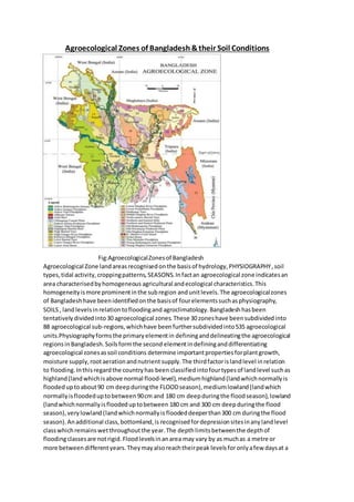
  • 1. Agroecological Zones of Bangladesh &their Soil Conditions Fig:AgroecologicalZonesof Bangladesh Agroecological Zone landareasrecognisedon the basisof hydrology,PHYSIOGRAPHY,soil types,tidal activity,croppingpatterns, SEASONS.Infactan agroecological zone indicatesan area characterisedbyhomogeneous agricultural andecological characteristics.This homogeneityismore prominentinthe subregion andunitlevels.The agroecologicalzones of Bangladeshhave beenidentifiedonthe basisof fourelementssuchasphysiography, SOILS, land levelsinrelationtofloodingand agroclimatology.Bangladesh hasbeen tentatively dividedinto30 agroecological zones.These 30zoneshave beensubdividedinto 88 agroecological sub-regions,whichhave been furthersubdividedinto535 agroecological units.Physiographyformsthe primaryelementin defininganddelineatingthe agroecological regionsinBangladesh.Soilsformthe second elementindefininganddifferentiating agroecological zonesassoil conditions determine importantpropertiesforplantgrowth, moisture supply,rootaerationandnutrient supply.The thirdfactorislandlevel inrelation to flooding.Inthisregardthe countryhas been classifiedintofourtypesof landlevel suchas highland(landwhichisabove normal flood-level),mediumhighland(landwhichnormallyis floodeduptoabout90 cm deepduringthe FLOODseason),mediumlowland(landwhich normallyisfloodeduptobetween90cm and 180 cm deepduringthe floodseason),lowland (landwhichnormallyisfloodeduptobetween 180 cm and 300 cm deepduringthe flood season),verylowland(landwhichnormallyis floodeddeeperthan300 cm duringthe flood season).Anadditional class,bottomland,is recognisedfordepressionsitesinanylandlevel classwhichremainswetthroughoutthe year.The depthlimitsbetweenthe depthof floodingclassesare notrigid.Floodlevelsinanarea may vary by as muchas a metre or more between differentyears.Theymayalsoreachtheirpeak levelsforonlyafew daysat a
  • 2. time duringa particularyear.These classesactuallyindicate the level of flooding which farmersexpectwhen theydecidewhichCROPStogrow inthe kharif seasonontheir differentkindsof land,basedon theirlongexperience of cultivationonparticular sites. Highland may be suitable for kharif or perennial DRYLAND crops if the soils are permeable. Impermeable soils or soils which can be made impermeable by PUDDLING may be suitable for transplanted aus and/or aman paddy if bunds are made to retain rainwater on fields. Medium highland is suitable for crops which can tolerate shallow flooding, such as broadcast or transplanted aus paddy, JUTE and transplanted aman paddy. Early kharif dryland crops which mature before flooding starts can be grown on permeable soils, and late kharif and early rabi dryland crops on soils which drain in September-October. Medium lowland is flooded too deeply for transplanted aus or transplanted aman paddy to be grown reliably. Mixed broadcast aus and deepwater aman is a common practice; or long aman seedlings may be transplanted as the floodwater recedes. Dryland rabi crops are widely grown on soils which drain in October or November. Lowland is flooded too deeply for broadcast aus or transplanted aman to be grown.Deepwater aman is typically grown on such land, although the cultivation of irrigated boro paddy on such land in the dry season now precludes the cultivation of deepwater aman over considerable areas of lowland. Dryland rabi crops can only be grown if flood water recedes before December. Very low land generally is too deeply flooded for even deepwater aman to be grown.Bottomland stays too wet for paddy to be sown broadcast. The traditional crop on such land is local boro paddy, either not irrigated or irrigated by traditional low-lift IRRIGATION devices. In a few other areas where flooding normally does not exceed 1.5m, very long aman paddy seedlings are transplanted early in the MONSOON season.The fourth element considered in identifying agroecological zones in Bangladesh comprises the four climatic zones of the country. The combined agroclimatic zones could be superimposed on the zones and sub-regions to create unique agroecological units. The Agroecological Zones (AEZ) database is unique and is being extensively used for national and local level production planning purposes.The agroecological resources are increasingly playing an important role in agricultural planning, technology transfer and specific bio-physical resource utilisation programme activities. The database on AEZ, however, needs updating as over time there have been some changes in the land types because of roads and other structural measures, variability in precipitation and TEMPERATURE as well as innovation of modern crop cultivation which could survive under different environmental stressconditions. A brief descriptionof 30 AEZ regionsisgivenbelow: Zones/Regions Sub Regions 1. Old HimalayanPiedmontPlain a) North-central;b)Northern; c) Southern 2. Active TistaFloodplain Active TistaFloodplain 3. Tista MeanderFloodplain a) Central;b) Eastern;c) LowerAtrai Floodplain;d) Lower Little JamunaFloodplain;e) North-easternandSouthernNorth-western;f)UpperLittleJamuna and Middle Atrai Floodplain 4. Karatoya-Bangali Floodplain a) NorthernandCentral;b) South-western 5. Lower Atrai Basin LowerAtrai Basin 6. Lower Punarbhaba Floodplain LowerPunarbhabaFloodplain
  • 3. 7. Active Brahmaputra-JamunaFloodplain Active Brahmaputra-JamunaFloodplain 8. Young Brahmaputraand JamunaFloodplain a) High JamunaFloodplain;b)Upper BrahmaputraFloodplain;c) UpperBrahmaputra-JamunaFloodplain 9. Old Brahmaputra Floodplain a) Bansi Valley;b) High;c) Low; d)MediumHigh;e)MediumLow 10. Active Ganges Floodplain Active Ganges Floodplain 11. HighGanges River Floodplain a) Central and Southern;b) Ganges- MahanandaFloodplain;c)Northern 12. Low Ganges River Floodplain a) Central;b) Eastern 13. GangesTidal Floodplain a) KhulnaSundarban;b) Nonsaline,calcareous;c)Nonsaline, calcareousand non calcareous;d)Nonsaline, noncalcareous;e) Saline,AcidSulphate Soils;f) Saline, calcareousand noncalcareous;g) Saline,noncalcareous 14. Gopalganj-KhulnaBeels Beel centres 15. Arial Beel Arial Beel 16. Middle MeghnaRiver Floodplain Middle MeghnaRiver Floodplain 17. LowerMeghna River Floodplain a) Calcareous,flood protected;b) Calcareous,unembanked;c) Noncalcareous,floodprotected;d)Noncalcareous, unembanked 18. YoungMeghna Estuarine Floodplain a) Nonsaline:Central Bhola;b) Nonsaline:MeghnaEstuaryCharland;c) Nonsaline:North Bhola;d) Saline:Central Bhola;e) Saline:Noakhali,HatiyaandMeghnaEstuary;f) Saline:SandwipandSouth Bhola 19. OldMeghna Estuarine Floodplain a) Dhaka-Narayanganj- DemraProjectArea;b)High:OldMeghna Estuarine Floodplain;c) Low:Daudkandi-Habiganj;d) Low:Dhaka- Shariatpur- Barisal;e) Low:Eastern Kishoreganj;f) Low:Gopalganj Beels margins;g) Low:Habiganj-NorthBrahmanbaria;h) Low: Titas Floodplain;i) MediumLow;j) Very poorlydrained: Laksham-Begumganj 20. EasternSurma-Kushiyara Floodplain Eastern Surma-KushiyaraFloodplain 21. SylhetBasin a)Central andSouthern; b) Northern;c)Western
  • 4. 22. NorthernandEasternPiedmontPlain a) Northernand EasternBasins;b) NorthernandEastern PlainsandBasins;c)North-westernPlains andBasins;d) South Sylhet PiedmontPlains 23. ChittagongCoastal Plain a) BeachRidges, Mangrove Swampand Mud Clay;b) Mangrove Tidal Floodplain;c) PiedmontPlainsand RiverFloodplains; d)YoungTidal Floodplain 24. St Martin’s Coral Island St. Martin’sCoral Island 25. Level Barind Tract a) Highland andMediumHighland;b)MediumLowlandand Lowland 26. HighBarind Tract HighBarindTract 27. North-easternBarindTract a) Mainlypoorly drained;b) Mainlywell drained;c) Mixedwell drainedandpoorly drained 28. MadhupurTract a) Mainlypoorly drainedlevel terrace; b) Mainlywelldrained dissectedterrace 29. Northernand EasternHills a) Low hillsand PiedmontPlains;b) Mainlyhighhill ranges;c) Mainlylowhills 30. AkhauraTerrace AkhauraTerrace DESCRIPTION OF AGROECOLOGICALZONES OF BANGLADESH: 1.Old Himalayan PiedmontPlain(4,008 sqkm) this distinctive regionisdevelopedinanoldTista alluvial fanextendingfromthe footof the HIMALAYAS.It has a complex relief pattern.Deep,rapidly permeable sandyloamsandsandy clayloamsare predominantinthis region.They are strongly acidicin TOPSOILandmoderately acidicinSUBSOILS; low inweatherable K minerals.Sevengeneral soil typesoccurin the region,of whichnon-calcareousbrownfloodplain soils,blackterai soils,and non-calcareousdark greyfloodplainsoilspredominate.Organicmatter contentsare generallyhigher than inmost FLOODPLAIN soilsof Bangladesh.The natural fertilityof the soil ismoderate butwell sustained.Soil fertilityproblemsinclude rapid leachingof N,K,S,Ca, Mg and B. Most of PANCHAGARHandTHAKURGAON districtsand the northwesternpartof DINAJPURdistrictare includedinthiszone. 2.Active Tista Floodplain(830 sqkm) thisregion includesthe active floodplainsof the TISTA , DHARLA andDUDHKUMAR rivers.It hascomplex patternsof low,generallysmoothridges,inter- ridge depressions,riverchannelsandcut-off channels.The areahasirregularpatternsof grey stratifiedSANDSandSILTS.Theyare moderately acidicthroughoutandparentalluviumismedium in weatherable Kminerals.Fourgeneral soil typesoccurinthe region,andof them, non-calcareous alluviumpredominates.OrganicmattercontentsandSOILFERTILITY level are low tomedium. 3.Tista MeanderFloodplain (9,468 sq km) this regionoccupiesthe majorpart of the Tistafloodplain as well asthe floodplainof the ATRAI,LITTLEJAMUNA , KARATOYA ,Dharla and Dudhkumarrivers. Most areas have broad floodplainridgesandalmostlevelbasins.There isanoverall patternof olive brown,rapidly permeable,loamysoilsonthe floodplainridges, andgreyordark grey,slowly permeable,heavy siltloamorsiltyclayloamsoilsonthe lower landandPARENTMATERIALS mediumin weatherable Kminerals.Eightgeneral soil types occurinthe region,moderatelyacidic throughout, lowinorganicmattercontenton the higherland, butmoderate inthe lowerparts. Fertilitylevelis lowtomedium.Soils,ingeneral,have good moisture holdingcapacity. 4.Karatoya-Bangali Floodplain(2,577 sq km) this regionisverysimilartothe Tista Meander Floodplaininphysiographyandsoil,and comprisesamixture of Tistaand BRAHMAPUTRA sediments.Mostareashave smooth,broad,floodplainridgesandalmost level basins.The soilsare
  • 5. greysiltloamsand siltyclayloamsonridgesandgrey or dark grey claysin basins.Five generalsoil typesoccur in the region,of whichnon-calcareousgrey floodplainandnon-calcareousdarkgrey floodplainsoilspredominate.The soil is moderatelyacidicthroughout.Organicmattercontentsare generallylowinthe cultivatedlayerof ridge soils andmoderate inbasins.Generalfertilityis medium.The easternhalf of BOGRA andmost of SIRAJGANJdistrictsare includedin thiszone. 5.Lower Atrai Basin (851 sq km) thisregion comprisesthe low lyingareabetweenthe BARIND TRACT and the Gangesriverfloodplain.Itincludesthe CHALAN BEELarea. Dark grey, heavy,acidic claysare predominate inthis smoothlow-lyingbasinland.Sevengeneralsoil typesoccurin the region.Organicmatter,andstatus of otheressential nutrientsare medium, while level of available K (potassium) ishigh.Fertilitystatusof soilsismoderate. 6.Lower Punarbhaba Floodplain (129 sq km) this small regionoccupiesbasinsandBEELSseparated by lowfloodplainridges.Inthisarea, darkgrey,mottled red,verystronglyacid,heavyCLAYSoccupy bothridge and basinsites.Organicmatterstatusismediumtohigh.General fertilitylevel ismedium withhighK-bearingminerals.The westernpartof NAOGAON andthe northern partof NAWABGANJ districtsare includedinthisAEZ. 7.Active Brahmaputra-Jamuna Floodplain(3,190 sqkm) thisregion comprisesthe beltof unstable alluvial landalongthe Brahmaputra-Jamunarivers where landis constantlybeingformedand erodedbyshiftingriverchannels.Ithasan irregularreliefof broadandnarrow ridgesand depressions.The areaisoccupiedbysandyand siltyalluvium, rich inweatherable Kmineralsthatare slightlyalkalineinreaction.Six general soil typesoccupythe area.Organicmatterstatus is low and fertilitystatusislowtomedium. 8.Young Brahmaputra and Jamuna Floodplain (5,924 sq km) the regioncomprisesthe areaof Brahmaputrasediments.Ithasa complex relief of broadandnarrow ridges,inter-ridge depressions, partiallyinfilledcut-offchannels andbasin.Thisareaisoccupiedbypermeablesiltloamtosiltyclay loamsoilsonthe ridges and impermeable claysinthe basins,neutral to slightlyacidinreaction. General soil types includepredominantlygreyfloodplainsoils. Organicmattercontentislow in ridgesand moderate inbasins.Soilsare deficientinN,P, andS but the statusof K and Znare reasonable. 9.Old Brahmaputra Floodplain (7,230 sq km) this regionoccupies alarge area of Brahmaputra sedimentsbefore the rivershiftedtoitspresent JAMUNA channel about200 yearsago.The region has broadridgesand basins.Relief is irregular,especially nearthe oldandpresentriver channels. Soilsof the area are predominantlysiltloamstosiltyclayloamsonthe ridgesand clayin the basins. Organicmatter contentislowon the ridgesandmoderate inthe basins,topsoils moderately acidic but subsoilsneutral in reaction.General fertilitylevel islow. 10.Active GangesFloodplain (3,334 sqkm) this regionoccupiesunstablealluviallandwithinand adjoiningGANGESriver.Ithasirregularrelief of broadandnarrow ridgesand depressions interrupted bycut-off channelsandactive channels.The areahascomplex mixturesof calcareous sandy, siltyand clayeyalluvium.The general soiltypes,predominantlyinclude, calcareous,alluvium and calcareousbrown floodplainsoils. Soilsare low inorganicmatterand mildlyalkaline inreaction. General fertility levelismediumbutdeficientinN. 11.High GangesRiverFloodplain(13,205 sq km) thisregionincludesthe westernpartof the Ganges riverfloodplainwhichispredominantly highlandandmediumhighland.Mostareashave a complex relief of broadandnarrow ridgesand inter-ridge depressions.The upperpartsof highridgesstand above normal floodlevel.Lower partsof ridgesandbasinmarginsare seasonally shallowlyflooded.
  • 6. General soil types predominantlyinclude calcareousdarkgrey floodplainsoilsandcalcareousbrown floodplainsoils.Organicmattercontentinthe brownridge soilsis low buthigherinthe dark grey soils.Soilsare slightlyalkalineinreaction.Generalfertilitylevelislow. 12.Lower GangesRiverFloodplain (7,968 sq km) the regioncomprisesthe easternhalf of the Gangesriverfloodplainwhichislow-lying.The areahasa typical meanderfloodplainlandscape of broad ridgesandbasins.Soilsof thisregion are siltloamsand siltyclayloamsonthe ridges and silty clay loamto heavyclaysonlowersites.General soiltypes predominantlyinclude calcareous dark greyand calcareousbrown floodplainsoils.Organicmattercontentislow in ridgesand moderate in the basins.General fertilitylevel ismedium. 13.Ganges Tidal Floodplain(17,066 sqkm) this regionoccupiesanextensiveareaof tidal floodplain landin the southwestof the country. The greaterpart of thisregionhas smoothrelief havinglarge areas of salinity.Riverbanks generallystand aboutametre or lessabove the level of adjoining basins.Non-calcareousgrey floodplainsoil is the majorcomponentof general soil types.ACID SULPHATE SOIL alsooccupiesa significantpartof the area,where itisextremely acidicduringthe dry season.Mostof the topsoilsare acidicandsubsoilsare neutral to mildlyalkaline.Soilsof the SUNDARBANSareaare alkaline.General fertilitylevel ishigh,withmediumtohighorganicmatter content. 14.Gopalganj-KhulnaBeels(2,247 sqkm) the regionoccupiesextensivelow-lyingareasbetweenthe Gangesriverfloodplainandthe Gangestidal floodplain.Soilsof the areaare grey,and dark grey, acidic,heavyclaysoverlay PEATor muckat 25-100 cm. General soil typesinclude mainlypeatand non-calcareousdark greyfloodplainsoils.Organicmattercontentis mediumtohigh.Fertility level is medium. 15.Arial Beel (144 km) thisregionoccupiesalow-lyingbasinbetweenthe Gangesanddhaleshwari riversinthe southof the formergreaterDHAKA district.Ithas much incommonwiththe lower Atrai Basinand the Gopalganj-KhulnaBeels.The soilsof thisareaare dark grey,acidicheavy clays.Non- calcareousdark greyfloodplainsoil isthe chief general soil type.Organicmattercontentgenerally exceedstwopercentinthe top subsoil.Available moisture holdingcapacityis inherentlylow. General fertilitylevelismediumto high. 16.Middle Meghna RiverFloodplain (1,555 sq km) thisregionoccupiesanabandonedchannel of the Brahmaputrariveron the borderbetweenthe greaterDhakaandCOMILLA districts.The region includesareasof oldBrahmaputrachars within the MEGHNA riveras well asadjoiningpartsof the mainland.Soilsof the areaare grey loamon the ridgesand greyto dark greyclays inthe basins.The dominantgeneral soil type isnon- calcareousgreyfloodplainsoil.Topsoilsare stronglyacidicand subsoilsslightlyacidicto slightlyalkaline.General fertilitylevel ismedium withlow N andorganic matter. 17.Lower MeghnaRiver Floodplain (909 sq km) this area occupiesthe transitional areabetweenthe middle Meghnariverfloodplainandthe young Meghnaestuarine floodplain.Soilsof thisarea are relativelyuniform,siltloamsoccupyrelatively higherareas andsiltyclayloamsoccupythe depressions.Non-calcareousdarkgreyfloodplain andcalcareousgreyfloodplainsoils are major componentsof general soil types.Topsoilsare moderatelyacidicandsubsoilsneutral in reaction. General fertilitylevelismediumtohigh withlow tomediumorganicmatterstatusandK- bearing minerals. 18.Young Meghna Estuarine Floodplain (9,269 sq km) thisregion occupiesyoungalluvial landin and adjoiningthe Meghnaestuary.The majorsoilsare greyto olive,deepcalcareoussiltloam andsilty
  • 7. clay loams,andare stratifiedeitherthroughoutorat shallow depth.Calcareous alluviumandnon calcareousgreyfloodplainsoils are the dominantgeneral soil types.Topsoilsandsubsoilsof the area are mildlyalkaline. General fertilityismediumbutlow inN and organicmatter. 19.Old Meghna Estuarine Floodplain (7,740 sq km) thisregionoccupies alarge area, mainlylow- lyingland betweenthe southof the Surma-Kushiyarafloodplainandthe northernedge of the young Meghna estuarine floodplain.Siltloam soilspredominateonhighlandsandsiltyclayto clayon lowlands.Organicmattercontentof the soilsare moderate.Topsoilsare moderatelyacidic,but subsoilsneutral inreaction.General fertilitylevel ismedium. 20.Eastern Surma-Kushiyara Floodplain(4,622 sq km) thisregion occupiesthe relativelyhigherparts of the Surma-KushiyarafloodplainformedonSEDIMENTS of the riversdrainingintothe Meghna catchmentarea fromthe hills.Thisaream isoccupiedby grey,heavysiltyclayloamson the ridges and claysinthe basins.Organicmattercontentof the soil ismoderate.Soil reactionranges from stronglyacidicto neutral. 21.Sylhet Basin (4,573 sq km) the regionoccupies the lower,westernside of the Surma-Kushiyara floodplain.Reliefis locallyirregularnearrivers.Soilsof the areaare greysiltyclayloamsand clay loamon the higherpartsthat dry out seasonallyandgreyclaysinthe wetbasins.The soilshave a moderate contentof organicmatterand soil reactionis mainlyacidic.Fertilitylevel ismediumto high. 22.Northern and WesternPiedmontPlains (4,038 sq km) thisisa discontinuousregionoccurringas a narrow stripof landat the footof the northern and easternhills.The regioncomprisesmerging alluvial fanswhichslopegentlyoutwardfromthe footof the northernand easternhillsinto smooth, low-lyingbasins.Greypiedmontsoils andnon-calcareousgreyfloodplainsoilsare the majorgeneral soil typesof the area.Soilsof the area are loamsto clays,slightlyacidictostronglyacidicinreaction. General fertilitylevelislowtomedium. 23.Chittagong Coastal Plain (3,720 sq km) thisregionoccupiesthe plainlandingreater CHITTAGONGdistrictand the easternpart of FENI district.Itisa compoundunitof piedmont, river, tidal andestuarine floodplainlandscapes. The majorproblem inthese soilsishighsalinity duringthe dry season(OctobertoMay).Grey silt loamsand siltyclayloamsoilsare predominant. Acidsulphate floodplains.Generalfertilitylevelof the soilsis medium,butN and K are limiting.Organicmatter contentislowto moderate. 24.St Martin'sIsland (8 sq km) thissmall but distinctive regionoccupiesthe whole of ST MARTIN'S ISLANDinthe extreme southof the country.The areahas verygentlyundulatingold beachridges and inter-ridgedepressions, surroundedbysandybeaches.The soilsare developed entirelyonold and youngCORALbeach sands. Calcareousalluviumisthe only general soil type of the area.General fertility level islowwithpoormoisture holdingcapacity. 25.Level Barind Tract (8 sq km) thisregionis developedoverMADHUPURCLAY . The landscape is almostlevel.The predominantsoils have agrey,silty,puddledtopsoil with ploughpan.Shallow grey terrace soil and deep greyterrace soilsare the majorcomponentsof general soil typesof the area. The soilsare low inavailable moisture holdingcapacityand slightlyacidictoacidicinreaction. Organicmatter statusisverylowand most of the available nutrientsare limiting. 26.High Barind Tract (16 sq km) itincludesthe southwesternpartof the BarindTract where the underlyingMadhupurClayhadbeenupliftedand cutintoby deepvalleys.The soilsinclude puddled siltloamto siltyclayloaminthe topsoilsandporous siltwithmottledplasticclayatvaryingdepth.
  • 8. Deepgreyterrace soilsandgrey valleysoilsare majorcomponentsof the general soil typesof the area.General fertilitystatusis low,havinglow statusof organicmatter. 27.North Eastern Barind Tract (1,079 sqkm) this regionoccupies several discontinuousareasonthe north-easternmarginsof the Barind Tract.It has siltyor loamy topsoil andclayloamsto claysubsoil. The soilsare stronglyacidicinreaction. Organicmatterinthe soilsislow.General fertilityispoor. 28.Madhupur Tract (4,244 sq km) thisisa regionof complex relief andsoils developedoverthe Madhupur Clay.The landscape compriseslevelupland,closelyorbroadlydissectedTERRACES associatedwitheithershallow orbroad,deep valleys.Eleven generalsoil typesexistinthe areaof whichdeepredbrownterrace,shallow redbrownterrace soilsandACIDBASIN CLAYS are the major ones.Soilsinthe valleysare dark greyheavyclays.Theyare stronglyacidicin reactionwithlow statusof organicmatter,low moisture holdingcapacityandlow fertilitylevel. 29.Northern and Eastern Hills(18,171 sq km) this regionincludesthe country'shill areas.Reliefis complex.Hillshave beendissectedtodifferent degreesoverdifferentrocks.Ingeneral,slopesare verysteepandfewlowhillshave flat summits.BROWN HILLSOILS isthe predominantgeneral soil type of the area.Organic mattercontentandgeneral fertilitylevel are low. 30.Akhaura Terrace (113 sqkm) this small region occupiesthe easternborderof BRAHMANBARIA and the southwestcornerof HABIGANJdistrict. The mainsoilsinthe uplandshave strongbrown clay.The valley soilsrange fromsiltyclayto clays.Deepredbrownterrace soils,grey piedmontsoils and acidbasinclays are the majorcomponentsof the general soil typesof the area.The general fertilityincludingorganicmatterstatus islow.The soilsare strongly acidicinreaction. (Source:BibliographyFAO/UNDP,LandResources Appraisal of BangladeshforAgricultural DevelopmentReport2:Agroecological Regions of Bangladesh,FAO/UNDP,1988; BangladeshBureau of Statistics,1998 Yearbookof Agricultural Statistics,BBS,Dhaka,1999.)