Hydro geology slides 41 to 46
•
1 like•399 views

Hydro geology on the Sandstone Ridge. Workshop slides presented by Gordon Coombs of AMEC

Recommended
More Related Content
Recently uploaded
Recently uploaded (20)
Featured
Featured (20)
Hydro geology slides 41 to 46
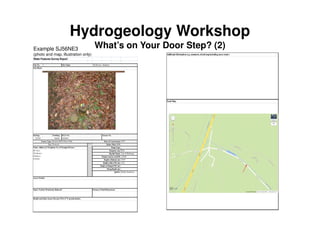
- 1. Hydrogeology Workshop What’s on Your Door Step? (2) Water Features Survey Report Site No. Easting: Northing: 355520 368360 1870 0.66 Top of Well-head 119.00 10.97 4.50 Helsby Sandstone Access Details: Open / Sealed / Permission Refused? Stream or Pond Dimensions: Health and Safety Issues Present (Y/N); if 'Y' provide details: SJ56NE3 Source Type: Borehole BGS (Water Well) Date of Construction Use: Domestic Mains Water Y/N: Name, Address & Telephone No. of Occupier/Owner: Pump Type: Mr Vicar, The Rectory Delamere, Cheshire Diameter (m): Dip Ref Mark: Datum (source) mAOD: Depth to Bottom (m): Depth to Rest WL(m): Depth to Pumped WL(m): Pump Depth (m): Aquifer: B.G.S No. Licence No. 1 Site Name: The Rectory, Delamere Site Photo: Additional Information (e.g. comments, sketch mapincluding access route): Local Map: Example SJ56NE3 (photo and map, illustration only)
- 2. Hydrogeology Workshop What’s on Your Door Step? (3) Additional Information (e.g. comments, sketch mapincluding access route): Local Map: Water Features Survey Report Site No. Easting: Northing: 355520 368360 1870 0.66 Top of Well-head 119.00 10.97 4.50 Helsby Sandstone Access Details: Open / Sealed / Permission Refused? Stream or Pond Dimensions: Health and Safety Issues Present (Y/N); if 'Y' provide details: SJ56NE3 Source Type: Borehole BGS (Water Well) Date of Construction Use: Domestic Mains Water Y/N: Name, Address & Telephone No. of Occupier/Owner: Pump Type: Mr Vicar, The Rectory Delamere, Cheshire Diameter (m): Dip Ref Mark: Datum (source) mAOD: Depth to Bottom (m): Depth to Rest WL (m): Depth to Pumped WL (m): Pump Depth (m): Aquifer: B.G.S No. Licence No. 1 Site Name: The Rectory, Delamere Site Photo: Example SJ56NW10 (photo and map, illustration only)
- 3. Questions?
- 4. Useful Links 1. Digital Geological Mapping Go to British Geological Survey (BGS) ‘Geology of Britain Viewer’ @ http://www.bgs.ac.uk/discoveringGeology/geologyOfBritain/viewer.html Click on ‘Open Geology of Britain Viewer’ Click on ‘Got to location’ (top right) Enter location (e.g. Delamere or Beeston) and click search 1:50,000 scale map should appear Click ‘Geology Key’ to see what rocks are shown (clicking on individual items in the key will give you detailed descriptions of the formation) +/- allows zoom in/out (the scale of mapping changes and the level of detail in the geological key also changes to match) You can click on options for showing bedrock only, superficial/Drift only, or both bedrock and superficial/Drift Adjust ‘transparency’ to see underlying OS background map more clearly (for orientation) Grid reference follows the cursor, so you can pin-point exact locations
- 5. Useful Links 2. Identify water wells and boreholes in the area (only those for which BGS has records) Possibly a useful starting point for identifying wells/boreholes for which more information is required. Go to British Geological Survey (BGS) ‘GeoIndex’ @ http://www.bgs.ac.uk/geoindex/ Click on ‘Open the onshore Geoindex’ Click ‘Go to Location’ (top) Enter location then ‘go’ Click ‘Search’ (top) Select appropriate category (e.g. Water wells) from ‘Select layer to search’ Click ‘Rectangle’ Move cursor to corner of your area of interest and drag across. A list of the borehole/wells in that area will appear. Hover cursor over item in the list and its position on the map will be highlighted. Use scroll-bar on right to view whole list. List provides basic details of wells/boreholes and indicates what sort of info (if any) is available on the respective well/borehole log.
- 6. Useful Links 3. To obtain downloads of individual well/borehole logs. Go to British Geological Survey (BGS) ‘Geology of Britain Viewer’ @ http://www.bgs.ac.uk/discoveringGeology/geologyOfBritain/viewer.html Click on ‘Open Geology of Britain Viewer’ Click on ‘Got to location’ (top right) Enter location (e.g. Delamere) and click search 1:50,000 scale map should appear Click on ‘Borehole Scans’ and lots of dots appear (colour coded according to well/borehole depth) Use info, such as grid ref and depth, from your list of boreholes (from GeoIndex) to guide cursor to well/borehole of interest. Click over the point of interest and the name/number of the well/borehole appears Check that it is the one you want and, if available click on ‘Scan Available View Online’ and a copy of the well/borehole log will download. Print/Save etc (please note these can only be saved one page at a time i.e. If a log is 8 pages long, you will need to save 8 separate files.