
Recommended
More Related Content
What's hot
What's hot (20)
Similar to earthquakes ks2 presentation.pptx What is earthquake?
Similar to earthquakes ks2 presentation.pptx What is earthquake? (20)
Recently uploaded
Recently uploaded (20)
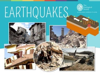
earthquakes ks2 presentation.pptx What is earthquake?
- 3. Pacific plate Eurasian plate North American plate South American plate African plate Indian plate Australian plate Arabian plate Antarctic plate Caribbean plate Nazca plate
- 4. Eurasian plate Caribbean plate Nazca plate North American plate Pacific plate South American plate Indian plate African plate Antarctic plate Australian plate Arabian plate
- 7. Stress
- 14. P waves arrive first S waves arrive next Surface waves arrive last P - S wave time interval
- 15. 1 2 3 P S P S P S
- 16. Computer controlled weights on roof Open areas for evacuation Fire resistant building materials Rubber shock absorbers Foundations sunk into solid rock Cross bracing – allows building to twist Road – quick access for emergency services Automatic shutters
- 17. In teams build an earthquake resistant structure that is at least 30cm tall and has a minimum of three floors. Each floor must support one weight. Tips to make your structure more earthquake proof: • Wide base • Solid foundation • Symmetrical design • Think about additional supports • Think about where you might put additional weight Masking tape Lollipop sticks Card
- 19. Beware this can be messy! Plastic box Sand Plastic board Cardboard or Lego Water
- 22. Fukushima Nuclear Power Station Epicentre Tokyo Location Tohoku, Japan Date 11 March 2011, 14:46 Magnitude 9 Fatalities 15,894 Injuries 6,156 Cost $235 billion
- 23. Damage to a primary school gymnasium in Nakano, Japan Flooding in Sendai Airport from the tsunami Fukishima nuclear power station © www.fukishimawatch.com
- 25. Location Gorkha, Nepal Date 25 April 2015, 11:56 Magnitude 7.8 Fatalities 8,964 Injuries 21,592 Cost $2.5 - 10 billion Epicentre Kathmandu Mount Everest
- 26. Earthquake destruction in Bhaktapur, Nepal Collapsed buildings in Chautara, Nepal
- 27. Shaking and vibration of the Earth's surface due to movement of the Earth's plates. Eruption of molten rock from below the Earth’s surface A huge wave that travels across the ocean What is an earthquake?
- 28. What is released during an earthquake? Gas Lava Seismic waves Water
- 29. Where do most earthquakes occur? In the middle of plates At plate boundaries In the UK
- 30. The point where an earthquake happens is called the … Epicentre Focus Inner core Aftershock
- 31. What does a seismograph measure? The height of a tsunami Damage caused by an earthquake The vibrations from an earthquake
- 32. Which type of earthquake wave arrives first? P wave S wave Surface wave
- 33. Which type of earthquake wave arrives last? P wave S wave Surface wave
- 34. When might a tsunami occur? When an earthquake occurs in the middle of a continent When an earthquake happens under the sea When the moon is closest to the Earth
- 35. Which of these methods does not help protect coastal regions and people from tsunamis? Planting more trees along the coast Constructing buildings on stilts Ignoring tsunami warnings Educating the public about tsunamis
- 36. Why did the Fukishima nuclear power station shut down in 2011? The shaking from the earthquake caused the power station to collapse The tsunami flooded the power station and shut off the power
Editor's Notes
- Earthquakes are natural vibrations caused by sudden movements in the Earth’s crust, the Earth’s thin outer layer. Earthquakes are a type of natural hazard. Q: Can anyone explain what a natural hazard is? A: Natural hazards are natural events that cause damage to property (like houses and farms) people and the environment. Other natural hazards are things like volcanoes, tsunamis, tornadoes, hurricanes and floods. Earthquakes are natural hazards because the shaking of the Earth’s surface can cause city buildings to collapse and injuring and sometimes killing thousands of people. Geologists study earthquakes to understand where they might happen and how people can be prepared and protected when an earthquake strikes. National Geographic montage of earthquakes https://video.nationalgeographic.com/video/earthquake-montage
- The Earth’s crust and upper parts of the mantle make up a thin skin on the surface of the Earth. This skin is not all in one piece but is broken up into huge slabs a bit like a giant jigsaw puzzle (point out different parts). These puzzle pieces are called tectonic plates and the edges of the plates are called plate boundaries. The plates move around on the surface of the Earth. You can’t feel the plates moving around because they move really slowly at about the same speed as your fingernails grow! The red lines on the map show the boundaries between the different tectonic plates. Get students to try to name some of the plates Click next slide to show plate names
- Here we can see all of the major tectonic plates.
- This is the same map but it has had yellow dots added to it. Q: What do you think the yellow dots are showing? A: Yellow dots are showing the location of major earthquakes on Earth. Q: What do you notice about where the yellow dots are? A: they are almost always near a plate boundary Almost all earthquakes that happen on Earth happen in the zones between two or more different plates which are called plate boundaries (point out a few plate boundaries with earthquakes).
- The edges of tectonic plates are jagged and rough. This means that when they push and grind past each other, at plate boundaries they generate lots of friction.
- Sometimes blocks of rock can become locked together. When this happens, the plates get stuck together the energy that would normally cause the blocks to move past each other is stored up.
- Eventually the stress builds up so much that the plates suddenly jolt into a new position. This movement releases vibrations called seismic waves which travel through the Earth, shaking the surface, including anything on it. This is an earthquake! Go through slides 6 -8 again if needed to show the earthquake happening
- The point at which the earthquake occurs below the Earth’s surface is called the focus, the point directly above the focus on the Earth’s surface is known as the epicentre.
- When an earthquake happens it releases vibrations which travel outward from the focus in every direction. When these vibrations reach the surface they cause the ground to shake. The vibrations travel as waves of energy known as seismic waves. Geologists measure these seismic waves at different stations around the Earth to work out where an earthquake has occurred. There are three main types of seismic wave. The first type are known as surface waves. They travel through the Earth’s crust away from the focus in all directions. They move from side to side and up and down – surface waves cause most damage to buildings in an earthquake. Click to show building damage
- The second type of seismic wave released from an earthquake is called a P wave. P waves travel through the whole Earth including the core. They travel through the Earth by pushing and pulling rocks in the direction they are travelling. Demonstrate with a slinky OR watch the first part of this YouTube video (https://www.youtube.com/watch?v=v2xhHRQkbNg) Get two students to hold either end of a slinky (metal ones are best). To demonstrate a P- wave one student needs to push the end of the slinky towards the other student.
- The third type of seismic wave is called an S wave, these waves from side to side as they go forward. S waves can’t travel through liquid so they can’t travel through the Earths outer core which is made from liquid metal. Demonstrate with a slinky OR watch the second part of this YouTube video (https://www.youtube.com/watch?v=v2xhHRQkbNg) Get two students to hold either end of a slinky (metal ones are best). To demonstrate an S wave one student move the slinky from side to side horizontally.
- Geologists measure seismic waves using instruments called seismographs. In the past, seismographs worked by having a pen suspended on a weight that then drew a line onto a rotating drum covered with graph paper. When the ground shook in an earthquake, the drum would go up and down and create a wiggly line on the drum. The more the ground shook the wigglier the line would be! Today geologists use seismographs which operate using a similar process but instead of pen and paper they use electromagnets which generate a voltage when there is an earthquake and this voltage is then transmitted to a computer display. The strength or size of an earthquake is called it’s magnitude. The bigger the earthquake, the more energy released and the bigger the earthquake’s magnitude. An earthquake with a large magnitude will make the Earth’s surface shake more and usually cause more damage than a smaller magnitude earthquake. As well as working out how big an earthquake is geologists also need to work out where an earthquake has struck. They do this by looking at the P and S seismic waves. S waves travel slower than P waves which means that the further you are away from the earthquake the more spread apart these two waves will be on your seismograph.
- As well as working out how big an earthquake is, geologists also need to work out where an earthquake has struck. They do this by looking at the P and S seismic waves. S waves travel slower than P waves which means that the further you are away from the earthquake the more spread apart these two waves will be on your seismograph.
- Imagine an earthquake has happened in the UK – stations around the country are set up to measure seismic waves. From the seismographs, the distance from the earthquake to the recording station is calculated by the time difference between the P and S waves. Click for Station 1 Station 1 in Newcastle detected seismic waves on their seismograph – they used the difference in time between the P and S waves to work out that an earthquake occurred 200km away but they do not know in which direction. The earthquake could have occurred at any point on the blue line so we haven’t really narrowed it down very much! Click for Station 2 Station 2 in Belfast detected seismic waves on their seismograph too – the P and S waves they detected were slightly closer together than those detected in Newcastle. They worked out that an earthquake occurred 125km away from them. We now have two cross overs one in west Scotland and one in North Wales so we have 2 possible locations for our earthquake. Click for Station 3 Station 3 in Cardiff also detected seismic waves. The P and S waves they detected were even closer together so the earthquake must have been closest to Cardiff out of the three cities. We now only have one spot which overlaps each of the circles so this is where the earthquake must have happened!
- Geologists know where earthquakes are likely to happen but it is impossible to predict when an earthquake will occur. It is important for earthquake-prone countries such as Japan to be prepared at all times. Engineering buildings to withstand earthquakes is extremely important in built up cities such as Tokyo in Japan. Engineering that allows buildings to ‘wobble’ instead of remaining still in an earthquake can help stop buildings collapsing and potentially save thousands of lives during a large earthquake. Other useful ways to stop building collapsing is to install computer controlled weights on the roof, build form fire resistant materials, install automatic shutters which prevent the windows for shattering and injuring people during an earthquake, make sure buildings have good road access and open areas for people to evacuate safely. Buildings can either be designed and build as earthquake resistant or they can be retrofitted – this means that new technologies can be applied to older buildings to help make them more resistant to earthquakes. Educating the public is also very important so that people know what to do if they feel an earthquake. Generally staying indoors under a sturdy table or doorframe is the safest thing to do.
- You will need lots of paper straws or lollipop sticks, card and masking tape. Give students 10 minutes to create an earthquake resistant structure from their materials. Place structure on a tray and test how earthquake resistant each groups structure is by shaking the tray back ad forwards to see whether the structure survives. Structures with wide bases, solid foundations, symmetrical designs and cross bracing supports (two diagonal supports in an X shape) are likely to withstand the ‘earthquake’ better.
- Q: What is a tsunami? If the ocean floor moves suddenly in an earthquake it can cause the water above to form a series of huge waves called a tsunami. (Demonstration and video in next slide) Tsunamis spread out very quickly across the ocean (reaching speeds of up to 800km/hour!). Out in the ocean tsunami waves are usually only about 30cm high, however as they get closer to land, the sea becomes shallower and the tsunami waves are forced to slow down and increase in height, sometimes up to 40m! When tsunamis reach land they can destroy buildings, flood whole cities and kill and injure many people. It is therefore extremely important to educate people in regions where tsunamis might occur so they know how to stay safe. The best method for survival is for people to quickly get themselves to higher land. Coastal communities can also reduce the risks of tsunamis by planting more trees along the coastline to break up tsunami waves, constructing buildings on stilts and building tall platforms for people to get out of a tsunami’s path at short notice. Q: Does anyone know where a tsunami has happened? Bang goes the Theory BBC1 explanation of tusnamis : https://www.youtube.com/watch?v=xyKgamjegtQ
- Beware this can be messy – you might want to take this into the playground! For your tsunami in a box you will need: Plastic container – clear if possible but not necessary, plastic boxes/plastic trays work well Sand/pebbles/soil to make an island Cardboard/Lego to make houses Water Food colouring (not necessary but makes water a bit clearer to see) Chopping board/white board to push water Instructions to make a tsunami in a box 1. Get your ocean (plastic container) 2. Build up your island on one side of the container using sand 3. Make some houses to put on your island – using cardboard, Lego or anything else you want 4. Get some water in a bucket or watering can – if you have blue food colouring use this to make the water blue in colour 5. Pour the water into your container carefully so it forms a shallow ‘ocean’. Make sure not to cover your island! 6. Place the board at the opposite end of the container to the island. 7. Use the board to push a tsunami wave onto the island. Demonstration on next slide
- Demonstration click to show process of wave generation in the box. Pull the plastic board up from the bottom, this represents your earthquake and the shifting blocks of rock. Watch your tsunami wave rush towards the island. If you have time you could measure the speed of the wave using a stopwatch (time from when you lift the board to when the wave hits the island) and measuring the length of the box from the ocean end to the island. Use the equation speed = distance/time, so speed of wave = box length/ stopwatch time e.g. 20cm/5s = wave speed of 4cm per second. You could also add on some maths questions – if your island was 100cm away how long would it take for the wave to get there? If the wave was traveling at 5cm per second and took 200 seconds to reach the island what speed was it travelling? You could also get students to try and build tsunami defences to try and protect their villages using plants, lego, cardboard etc. to try and break up the wave or to elevate houses.
- The islands of Japan lie at a point where four major tectonic plates meet: the North American, Eurasian, Philippine and the Pacific plate. Over millions of years these tectonic plates have been moving around and the Pacific plate is slowly being pushed underneath Japan. This means that Japan has had a long history of earthquakes, volcanoes and associated tsunamis. In 2011 and earthquake occurred in Tohoku in Japan which resulted one of the most costly natural disasters of all time.
- The earthquake occurred in the ocean off the coast of the Tohoku region of Japan (yellow on the map) on the 11 March 2011 at 14:46 local time. It was a magnitude of 9 making it one of the largest ever earthquakes recorded. because earthquake occurred beneath the sea it triggered a tsunami that was 39 m high when it hit the coast of northern Honshu, the largest island of Japan. The tsunami caused widespread flooding, destroyed buildings and shutdown the Fukushima nuclear power station. The earthquake itself did not damage the power station but the flood waters from the tsunami cut off all on-site and off-site electric power to the power station and resulted in the nuclear reactor cores melting. Shutting down a nuclear power plant is very dangerous as it can release harmful radiation into the sea water and environment. Due to the danger of the radiation everyone within 20 km of the nuclear power station had to be evacuated and people living 20–30 km away were advised to stay indoors, for fear that they may be affected by the radiation. As a result of the earthquake and tsunami 15,894 people died, over 6000 were injured and 230,000 people were left homeless. This natural disaster cost the Japanese government $235 billion dollars. Click for images of earthquake destruction
- For the past 50 million years, the Indian plate has been travelling northwards into the Eurasian plate. This collision has caused the land to crumple, building the Himalayas, the largest mountain chain currently on Earth. As India moves into Eurasia, friction causes stress to build up. The stress is released when the plates suddenly move. These earthquakes greatly affect the countries of the Himalayas, such as Nepal, India and Pakistan. In 2015 an earthquake struck the Gorkha region of Nepal.
- The earthquake occurred on the 25 April 2015 at 11:56 local time. It had a magnitude of 7.8. Hundreds of thousands of people were made homeless by the earthquake as entire villages were flattened across many districts of the country. Centuries-old buildings were destroyed at UNESCO World Heritage Sites in the Kathmandu Valley. Almost 9000 people were killed in the earthquake however this death toll may have been minimized by the fact that most villagers were outdoors working when the quake hit meaning that they were not crushed by falling buildings, and also because the earthquake hit on a Saturday which meant that children and teachers were not inside the collapsing school buildings. At Mount Everest, the earthquake resulted in an avalanche at base camp which killed 22 people, making it the deadliest day in Everest history. Because Nepal is a very poor country the effects of the Gorkha earthquake will affect its economy for many years to come. Since the earthquake UNESCO has helped to rebuild damaged sites with extra reinforcements to protect them from future earthquakes. Other public buildings such, as schools, are also being built with earthquakes in mind and students are receiving disaster emergency training so that they know how to react should another earthquake occur.
- A: Shaking and vibration of the Earth's surface due to movement of the Earth's plates.
- C: Seismic waves
- B: At plate boundaries
- B: Focus
- C: The vibrations from an earthquake
- B: P wave
- A: S wave
- A: When an earthquake happens under the sea
- C: Ignoring tsunami warnings
- B: The tsunami flooded the power station and shut off the power