Recommended

Recommended
More Related Content
What's hot
Recently uploaded
Recently uploaded (20)
Metar poster
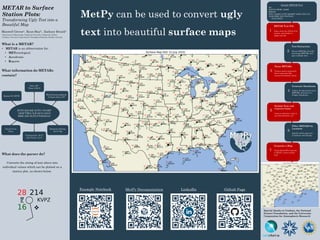
- 1. MetPy can be used to convert ugly text into beautiful surface maps What is a METAR? • METAR is an abbreviation for: • METeorological • Aerodrome • Reports What information do METARs contain? What does the parser do? Converts the string of text above into individual values which can be plotted on a station plot, as shown below. Maxwell Grover1, Ryan May2, Zachary Bruick2 1 Department of Meteorology, Valparaiso University, Valparaiso, Indiana 2 Unidata, University Corporation for Atmospheric Research, Boulder, Colorado METAR to Surface Station Plots: Transforming Ugly Text into a Beautiful Map Special thanks to Unidata, the National Science Foundation, and the University Corporation for Atmospheric Research MMETETPY KVPZ 262156Z AUTO 17010KT 10SM TSRA CLR 28/16 A3019 RMK AO2 SLP218 T02830161 Station ID: KVPZ Date: 26th Time: 2156 Z Wind Direction/Speed: 10 knots from 170° Cloud Cover: Clear Temperature: 28 °C Dew Point:: 16 °C Altimeter Setting: 30.19” Hg Sample METAR Text 561 SAUS70 KWBC 150000 METAR KIPJ 142350Z AUTO 25006KT 10SM CLR 31/21 A3008 RMK AO2 T03070210 10334 20307= Github PageLinkedInMetPy DocumentationExample Notebook METAR Text File Taken from the NOAA Port system, converted to a single text file 1 Parse METARs Using a parser generated from a grammar file, extract the desired values 3 Format Text and Convert Units Convert altimeter value to sea-level pressure, etc. 5 Generate a Map Using StationPlot function in MetPy, create surface map 7 Text Extraction Extract METARs from file and merge METARs that span multiple lines 2 Generate Dataframe Collect all information from METARs and store in a Pandas Dataframe 4 Filter METARS by Location Specify which region (ex. Louisiana) and spacing 6