1. Landslide Turns Explosive
Debris flows are a type of sediment gravity flow
(SGF) that are the result of heavy rainfall and in
catastrophic cases, volcanic eruptions. The
eruptions and debris flows of Mount St. Helens
have been incorporated into the geologic rock
record by compaction and cementation of
overlying rock. The importance of studying these
strata tell us the eruptive history of this relatively
young volcano, the mechanics, and the evolving
composition of the associated flows.
Abstract
On May 18, 1980 at 8:32 a.m., a 5.1
magnitude earthquake started the largest
recorded landslide, relieving stress that was
ready for eruption. The resulting low-angle
blast melted snow and glaciers that lowered
the viscosity of the debris flows, carrying
them faster and further down the slope and
buried trees and sediment. The sequence of
pictures in the poster heading show the
avalanche that proceeded the eruption.
Prehistoric Debris Flows of Mount St. Helens
Max Barnett
Department of Geology, Eastern Washington University
Bibliography
Flows Through Time
Radiocarbon dating of buried organic
material assists in characterizing strata
(Crandall 1987). This was not the first
nor the last of many eruptions of this
active volcano. Nine debris flow strata,
subdivided into nine eruptive periods,
indicate eruptions started around
40,000-50,000 ka (Mullineaux 1996)
and was followed by many eruptions
accompanied by debris flows. Strata is
also characterized by the abundance of
minerals found, be it mafic or felsic.
Modern Mount St. Helens is a
combination of mafic and silicic and Old
Mount St. Helens is mostly silicic.
Debris Flows
Unconsolidated sediment that is fast
flowing and fluid-like, moving down a
steep slope is called a debris flow.
Breakdown in sediment cohesiveness
overcomes the yield strength and the
integrity of internal structures give way to
gravitational forces (Boggs 1994). As
debris flows downhill and is deposited, it
may form a rare structure known as
reverse grading, which is sediment
sorting that coarsens upward. This
process is known as kinetic sieving.
Moving grains create voids that are
typically filled by smaller grains, keeping
the larger clasts on top (Gray and Hutter
1997). Shock waves from earthquakes
assist in the sieving process by shaking
and settling the smaller grains to pack
closer together. Larger grains are able to
travel greater distances; more often they
are found at the end of the flow rather
than at the beginning.
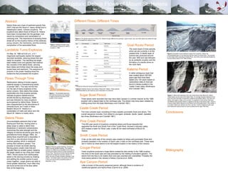
Different Flows, Different Times
Goat Rocks Period
The most recent of time periods,
which we are currently in at the
present time. A dacitic layer of
pumice was produced around
the year 1800 and was followed
by an andesitic eruption and the
formation of a dacite dome on
the north flank.
Kalama Period
Sugar Bowl Period
Castle Creek Period
Pine Creek Period
Smith Creek Period
Cougar Period
Ape Canyon Period
A rather ambiguous layer that
was created about 350-500
years ago that most likely
lasted only 100 years based on
radiocarbon data of charcoal
found in lahars located in the
Castle Creek valley (Mullineaux
and Crandall 1981).
Three lahars were recorded that may have been caused in a similar manner as the 1980
eruption with a lateral blast on the northeast side. The lahars may have been initiated by
melting snow from the blast (Mullineaux and Crandall 1981).
The most complex layer consisting of many basaltic pyroclastic flows and lahars. The
overall sequence includes, from oldest to youngest, andesite, dacite, basalt, repeated
two times (Mullineaux and Crandall 1981).
This 500 year period of eruptions contained lahars and fluvial deposits that
aggraded the North and South Fork of the Toutle River, blocked a tributary valley,
and created a basin for Silver Lake, a lake 50 km west-northwest of Mount St.
Helens.
A fan on the north side of the volcano was created by lahars and pyroclastic flows and
probably assisted in the creation of Spirit Lake, a lake on the northeast side. These were
set in motion by what seems to be the largest eruption in the history of this volcano.
Felsic eruptions produced a large debris avalanche also similar to the 1980 eruption,
this time on the south side and was preceded by the melting of prevalent glaciers. The
debris from the flow is 20 meters thick and was unsorted and unstratified. Probably the
most active period in the volcano’s history (Clynne et al. 2008).
Little is known of this poorly preserved period, although there is evidence of
residencial glaciers and tephra flows (Clynne et al. 2008).
Figure 1. Before and after maps
and pictures of Mount St. Helens’
eruption in 1980.
Figure 2. The landslide sequence
that relieved pressure and exposed
a magma intrusion that lead to the
eruption of the volcano.
Figure 4. The growth sequence of Mount St. Helens through different time periods. Layers of ash, lava, and other debris are added through
time to increase the volcano’s size.
Figure 5. Periods of time in the history of Mount St. Helens. These periods
are differentiated by the frequency and composition of eruptions.
Figure 6. Scientists record sediment supply from eruptions. Notice the
unconsolidated layer on the right that was the result of a debris flow. The scientist
on the bottom left is standing in Muddy River, one of the rivers that was flooded by
mud and debris flows in the 1980 eruption.
Figure 3. Reverse graded bedding. Sometimes
called inversely graded bedding. The smaller
sediment is sifted and consolidated at the bottom,
providing the ability of flow for larger sediment to
move on top. This picture shows a great example
of sediment sorting that coarsens upward, or
rather, the size of clasts increase vertically in this
section. The darker layers are periods of erosion
in this rock record with succeeding layers of
deposition on top.
Conclusions
Figure 7. Debris flow deposits in the rock record found near Mount St. Helens.
These layers can be around 20 meters thick. An average eruption displaces more
than one cubic kilometer of sediment containing pyroclastic debris, mud and rock
debris, and organic matter such as trees. It is apparent in this picture that there
are different time periods shown in regards to the type of structures seen. There is
a poorly sorted debris deposit on the bottom and a laminated layer in the middle. It
is unclear if these two sections are from one flow. Further analysis of grain type
and radiometric dating would be used to determine the age of the flow.