1. AN ITE JOURNEY DOWN UNDER
A Tale of Two Contrasting Waterfronts, Shared Streets, and a Hook Turn
MarshaAndersonBomar,AICP,ENVSP/TRAINER
Twenty years after my service as International
President of ITE, I was honored to be hosted
by ITE members in Australia and New Zealand
to visit and exchange knowledge about our
industryandtheworldaroundus.Weexplored
leadership, transportation innovations, and
the relationships between transportation,
land use, and economic development.
In pictures and words, this summary of just
a few of my experiences is written to give
you a taste of the journey and the depth of
opportunity opened up by the friendships
made through my engagement in ITE. Feel
free to contact me directly if you would like
more information—or better yet, go and visit
these wonderful places.
Southbank Melbourne
Along the banks of the Yarra River in Mel-
bourne, Australia, the former industrial area
of Southbank was transformed into a vibrant
neighborhood in the early 1990s. The decay-
ing wharves, factories, and warehouses
originally had been built between 1860 and
1920. To stimulate economic development,
the choice was made to develop almost all
new construction that now creates a live-
work environment with restaurants, shops,
public art displays, and an innovative arts
center.This modern place is connected to the
older downtown that is filled with both his-
toric buildings and contemporary buildings
that were constructed to meet current, high
sustainability standards. The numerous river
crossings are both functional and artistic.
The local planners seized an opportunity to
connect the port where the cruise ships arrive
in Southbank to downtown via a modern
streetcar line. The elegant old train station is
well connected to Southbank and opens up
easy connections to many other parts of Mel-
bourne, with frequent service on mostly new
trains. The area is quite pedestrian friendly,
and with so much to see, one is easily drawn
to zig and zag from one side of the river to the
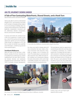
A view of the City of Melbourne, Australia skyline along the Yarra River.
One of many river crossings in Southbank along the Yarra River in Melbourne, Australia.
Guidance strips on the street help the sight
impaired to find croswalks.
AllPhotoscourtesyofMarshaAndersonBomar
16 February 2015 ite journal
| inside ite
2. other via the many bridges that provide great
views and access to new destinations.
Throughout the area there are interesting
pavement markings I had not seen before.
In addition to the raised pavements we often
see at the curbs by an intersection crossing,
they have raised stripes on the ground so
that visually impaired people have guidance
to get to a safe crosswalk.
Additional resource: www.melbourne.
vic.gov.au/AboutMelbourne/Precinctsand-
Suburbs/suburbprofiles/Pages/Southbank.
aspx
Waterfront Auckland
In contrast to the very successful new con-
struction project in Melbourne, Australia, the
waterfront redevelopment in the Wynyard
Quarter area of Auckland, New Zealand is
all about rehabilitating through re-use and
repurposing. The heritage and importance
of the harbor to residents and businesses is
evident in more details than can be shared
here. To highlight just a few examples:
• The visitor center is a repurposed ship-
ping container. Similarly, the area has
created a free library and a home for
a piano available for anyone to play in
shipping containers placed around the
area in keeping with the theme.
• A new playground includes a 7-meter
slide that is constructed to look like
the storage tanks in the surrounding
area. Some of the actual tanks that
are no longer in use have been turned
into works of art. One has been main-
tained as a viewing screen for movies
on the lawn.
• Street furniture mimics elements of the
ships and the harbor.
• Rails where containers used to be
moved are maintained. In one place,
wooden chairs are in place, but they
can be slid along the rails and con-
nected to form a performing arts stage.
A library in a repurposed shipping container.
Marsha Anderson Bomar seated in a chair
designed to look like a smokestack.
A bridge in Auckland, New Zealand is painted with a barcode design in tribute to the Wynyard
Quarter’s shipping heritage.
This visitor center in Auckland, New Zealand is made of repurposed shipping containers.
www.ite.org February 2015 17
3. • Restaurants are abundant and many
are housed in old warehouse buildings.
• Bridges connecting the downtown to
the waterfront celebrate the impor-
tance of the shipping industry through
walkways painted with bar codes.
• Arches and sculptures pay tribute to
the local Maori heritage and culture.
• A vast staircase that provides access for
pedestrians to the water was built to
work with the tides and the sea rise.
It is all about sustainability—every deci-
sion that is made for each element of every
project takes a long-term view. Whether it
is materials or the provision of many trans-
portation choices, this waterfront is and will
be active and successful for both the public
and the private sector. It is in the partner-
ship between the public (government and
citizens) and the private investors that many
of the benefits can be seen. The area attracts
people during the work day as well as eve-
nings and weekends.
Part of the focus on sustainability is the
economic development of the community,
and the projections make the story clear.
Waterfront Auckland expects that by 2040,
the waterfront will contribute more than $4
billion (NZ) to the economy, and that more
than 20,000 full-time jobs will be created and
another 20,000 indirect jobs throughout the
region.
Additional resource: www.waterfron-
tauckland.co.nz
Shared Streets in Auckland
Imagine a thriving business environment
where people can stroll, dine, or shop; deliv-
eries can be made; and you can be dropped
off at your front door. It sounds like a typi-
cal city street—except these shared streets
in Auckland, New Zealand are anything but
typical. There are no curbs defining where
the vehicles must stay. The pedestrian space
is not restricted to a typical sidewalk area.
There are no actual barriers, just visual clues,
as to how the space is to be used.
Of course, every street does not lend itself to
this concept, but where it is appropriate to
have slow moving traffic and high pedestrian
activity, you have an opportunity to create
something unique. It is a combined space,
not a place where activities are separated.
As traffic engineers continue to evaluate the
allocation of the precious and limited right of
way, the needs of many users must be con-
sidered. In addition, the businesses adjacent
to the street are impacted by many factors,
and included in those are the perception and
the reality of accessibility.
The local Auckland government carefully
proceeded with the design of its first Shared
Street and conducted extensive before and
after analyses of both traffic operations and
economic impact on the local business oper-
ations. Development of these spaces is more
costly than basic streetscape programs, and
so a special assessment was created for the
Central Business District (CBD) area. Special
signage was created to mark the entrance
and the end of the special zone.
The cross-section can be described as open
and accommodating. On each side of the
street there is an accessible area with no bar-
riers to reach the businesses. Moving toward
the center of the street is an activity zone. It is
the space for street furniture, outdoor dining,
trees, loading vehicles, and signage. The
This shared street in Auckland, New Zealand has accessible, activity, and traffic sections without
physical barriers.
A sign indicates a shared usage zone in
Auckland, New Zealand.
18 February 2015 ite journal
| inside ite
4. middle space is the traffic zone where pedes-
trians, moving vehicles, and other activities
take place. From the photo you can see that
there are no obstacles, curbs, or other phys-
ical impedances for pedestrian movement
from one zone to another. There are visual
cues created by widely spaced trees, changes
in pavement texture and drainage structures.
Each element and the materials used were
tested to ensure they met the objectives of
the shared space.
Concerns of the local businesses were heard
prior to the establishment of the first space.
The data analysis shows that indicators are
all encouraging: occupancy is up, real estate
values are up, and spending has increased.
Vehicular activity is down, but pedestrian
volumes are up measurably.
The successful implementation has led to
the implementation of several other shared
spaces with more under consideration. To
date, the streets selected have been lower
traffic volume locations. The positive experi-
ence has started the discussion about future
possibilities for higher volume roads.
Additional resource: www.auckland-
council.govt.nz/en/planspoliciesprojects/
councilprojects/sharedspaces/Pages/home.
aspx
Hook Turns in Melbourne
A variety of treatments have been used to
manage traffic at intersections. In the United
States, there are locations where“jughandles”
are used to have left turns become through
movements to create less conflict at the
intersection. In Australia, there are hook turns
(remember they drive on the left side of the
street, not the right), which function simi-
larly. The car pulls into a special location in
the middle of the intersection and is perpen-
dicular to its original flow. At the appropriate
moment, the car then moves across as a
through movement.
Thank You Notes
Many people helped to make this dream trip
a reality, and I need to extend some thanks. I
will surely leave a name out that should be
included, so forgive me. First and foremost,
thanks to Andrew O’Brien who asked me to
be the speaker at the President’s Dinner in
Melbourne. This began the conversation.
Andy also took precious time out of his very
busy schedule to show me some of the
beautiful sites. Thanks to Deborah Donald
for hosting me in her home and being a
great guide. Ken Ogden, Nick Szwed, and
John Smelt—ITE friends old and new—
showed me around Melbourne, including
the Southbank area. Don McKenzie in Auck-
land organized many wonderful activities
and hosted me in his home. He and his
family devoted a great deal of time to ensure
I enjoyed my free time. Thank you to Jenny
Parker, President of Women in Construction,
for a lot of planning time and for hosting me
upon my arrival in Auckland. Thank you to
Eric Van Essen, road development engineer
for Auckland CBD, for the tour of and infor-
mation about the Shared Streets. Thanks to
Alan Gray, senior urban designer with Water-
front Auckland for guiding me through the
Wynyard Quarter area. And final thanks to
the Australia/New Zealand Section of ITE and
ITE International for contributing to the fund-
ing for this most informative trip. itej
Marsha Anderson Bomar,
AICP, ENV SP/TRAINER is
Senior Principal, Transportation,
Sustainability Team at Stantec.
She founded Street Smarts in
1990, a transportation planning, engineer-
ing, and design firm that she sold to Stantec
in 2010. She had the honor of being the first
woman to serve as International President of
the Institute ofTransportation Engineers (ITE)
and was the first woman to ever receive the
ITE Burton Marsh Distinguished Service
Award. She has also served as President of
the American Society of Civil Engineers’
Transportation and Development Institute.
Marsha has more than 40 years of experience
in transportation planning, traffic engineer-
ing, public involvement, education and
training, meeting facilitation, traffic analysis,
management and administration of trans-
portation and traffic engineering projects,
master transportation plans and studies,
transit systems planning, parking studies and
design analyses, freight studies, modeling,
and general research. She has served 9 years
on the Duluth, GA, USA City Council and has
twice served as the Mayor Pro Tempore. She
holds a bachelor’s and a master’s degree
from the Polytechnic Institute of Brooklyn in
Mathematics and Transportation Planning
and Engineering, respectively. She also holds
a master’s of civil engineering with a concen-
tration in transportation from Princeton
University. Marsha is a Fellow of ITE.
A hook turn treatment for vehicle turns in
Melbourne, Australia.
www.ite.org February 2015 19