
Recommended
More Related Content
What's hot
What's hot (17)
Similar to Tourism
Similar to Tourism (20)
Recently uploaded
Recently uploaded (19)
Tourism
- 1. B1F | COLEGIO SUIZO AMERICANO| April 2, 2017 Tourism in Guatemala MARÍA FERNANDA SILVA
- 2. PAGE 1 Tourism in Guatemala has grown gradually, is an attractive destination because of the abundant and varied natural beauty and its long beaches of white sand and dark sand, coral reefs, abundant flora and fauna, and archaeological beauties, its colonial history, plus its entire culture expressed in their customs and traditional foods. There is a strong interest of the international community for archaeological sites like the city of Tikal was built and occupied in a period where the Mayan culture had its most literal and artistic expression, was ruled by a dynasty of 16 kings, the Mayas of Tikal built many temples, a ball park, altars and steles in high and low relief. Guatemala is very popular for its archaeological sites, pre-Hispanic cities as well as tourist-religious centers like Basilica of Esquipulas and City of Esquipulas and also the beautiful beaches on the Pacific and Atlantic coasts of Guatemala. Other tourist destinations are the National Parks and others Protected Areas such as the Maya Biosphere Reserve.
- 3. PAGE 2 GuatemalaCity Guatemala City, locally known as Guatemala or Guate, is the capital and largest city of the Republic of Guatemala, and the most populous in CentralAmerica.The city is located in the south-centralpart of the country, nestled in a mountain valley called Valle de la Ermita (English: Hermitage Valley). In 2009, it had a population of 1,075,000.[3][4] Guatemala City is also the capital of the local Municipality of Guatemala and of the Guatemala Department. LakeAtitlan Lake Atitlan is a lake in the Guatemalan Highlands of the Sierra Madre mountain range. It is in the Sololá Department of southwestern Guatemala. Atitlan means "at the water" in Nahuatl. Lake Atitlán is the deepest lake in Central America with a maximum depth ofabout 340 meters (1,120 ft.)[1] With an average depth of 220 meters (720 ft.).[2] Its surface area is 130.1 km2 (50.2 sq. mi).[1] It is approximately 12 by 5 km with around 20 km3 of water.Atitlan is technically an endorheic lake, feeding into two nearby rivers rather than draining into escarpments and three volcanoes on its southern flank. The area the ocean.It is shaped by deep surrounding supports extensive coffee and avocadoorchards anda variety offarm crops, most notably corn and onions. Significant agricultural crops include: corn, onions, beans, squash, tomatoes,
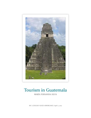
- 4. PAGE 3 cucumbers, garlic, chile verde,strawberries and pitahaya fruit. The lake itself is a significant food source for the largely indigenous population. Tikal Tikal (/tiˈkäl/) (Tik’al in modern Mayan orthography) is the ruin of an ancient city, which was likely to have been called Yax Mutal, found in a rainforest in Guatemala. Ambrosio Tut, a gum-sapper, reported the ruins to La Gaceta, a Guatemalan newspaper, which named the site Tikal. After the Berlin Academy of Sciences' magazine republished the report in 1853,archeologists and treasure hunters began visiting the forest.Today,tourism to the site may help protect the rainforest. It is one of the largest archaeological sites and urban centers of the pre-Columbian Maya civilization. It is located in the archaeologicalregion of the Petén Basin in what is now northern Guatemala. Situated in the department of El Petén, the site is part of Guatemala's Tikal NationalPark and in 1979 it was declared a UNESCO World Heritage Site. Tikal was the capitalof a conquest state that became one of the most powerful kingdoms ofthe ancientMaya. Thoughmonumentalarchitecture at the site dates back as far as the 4th century BC, Tikal reached its apogee during the Classic Period,c.200 to 900 AD.During this time,the city dominatedmuch ofthe Maya region politically, economically, and militarily, while interacting with areas throughout Mesoamerica such as the great metropolis of Teotihuacan in the distant Valley of Mexico. There is evidence that Tikal was conquered by Teotihuacan in the 4thcentury AD. Following the end oftheLate Classic Period, no new major monuments were built at Tikal and there is evidence that elite palaces were burned. These events were coupled with a gradual population decline, culminating with the site’s abandonment by the end of the 10th century. Tikal is the best understood ofany ofthe large lowland Maya cities, with a
- 5. PAGE 4 long dynastic ruler list, the discovery of the tombs of many of the rulers on this list and the investigation of their monuments, temples and palaces. Semuc Champey
- 6. PAGE 5 Semuc Champey is a natural monument in the department of Alta Verapaz, Guatemala,near the Q'eqchi' Maya town of Lanquín. It consists of a natural 300 m limestone bridge, under which passes the Cahabón River. Atop the bridge is a series of stepped, turquoise pools, a popular swimming attraction. Although it can be difficult to get to, Semuc is becoming more and more popular with travelers. Antigua Guatemala Antigua Guatemala commonly referred to as just Antigua orla Antigua) is a city in the central highlands of Guatemala famous for its well- preserved Spanish Baroque-influenced architecture as well as a number of ruins of colonial churches. It served as the capital of the Kingdom of Guatemala. It has been designated a UNESCO World Heritage Site. Antigua Guatemala serves as the municipal seat for the surrounding municipality of the same name. It also serves as the departmental capital of Sacatepéquez Department.
- 7. PAGE 6 Antigua Guatemala means "Ancient Guatemala" and was the third capital of Guatemala. The first capital of Guatemala was founded on the site of a Kakchikel-Maya city, now called Iximche,on Monday, July 25, 1524—the day of Saint James—and therefore named Ciudad de Santiago de los Caballeros de Goathemalan (City of Saint James of the Knights of Guatemala). Naturally, St. James became the patron saint of the city.