SlideShare a Scribd company logo
1 of 1
Raptor Migration Quantification at the UMD Farm 
Lance Gauer | Dr. Gerald Niemi | Department of Biology | Natural Resources Research Institute | University of Minnesota Duluth 
• SAP (Sustainable Agriculture Project) 
• WindTech Inc. 
• 5 kW Turbine 
• 80 ft. structure 
• Self-Raising Tower 
• Zero Contact Transmission Technology 
-Magnet based turbine 
Purpose 
• To obtain baseline data on the movement of 
raptors near the UMD Farm, in light of a 
proposed wind turbine installation. 
Concern 
• Hawk Ridge in Duluth, MN is the 2nd largest 
migratory pathway in the country. With a wind 
turbine proposed to be installed here, there is a 
concern on mortality for these migrating raptors. 
Project Overview 
• Underwent training on Identification and the data 
entry process in mid August before I began 
research independently. 
• Completed 96 hours of observation between the 
dates of 9/7/2013 and 11/7/2013. 
• Observation start times ranged from 9am to 
3:45 pm 
• Data were gathered in 1 hour increments 
Wind Turbine Project 
Materials 
Procedure 
Set Up 
-Set up Equipment 
-Enter 
Environmental 
Conditions 
Scan Identify 
-Scan 360 degree 
horizon. 
-Eyes 1st 
-Binoculars 2nd 
-Scope 3rd 
Record 
-Location 
-Assign Number 
-Flight direction 
-Name 
Data / Observations 
• What was recorded? 
• Height: 0=ground to canopy, 1=canopy-100m, 2=100m- 
500m, 3=500m and above 
• Distance: 1=0-400m, 2=400m-800m, 3=800m-1200m, 
4=1200m-1609m, 5=1609m-2414m. 
• Wind Speed & Direction 
• Temperature in degrees F 
• Sky 
• Visibility 
• Bird 
Results 
50 
45 
40 
35 
30 
25 
20 
15 
10 
5 
Flight Height + Distance vs. Individuals 
Figure 1. Total # of individual raptors counted at the farm divided into the heights and distances they were observed at. 
300 
250 
200 
150 
100 
50 
• Total # of raptors counted: 1012 
• Estimated total # of raptors from 
9/7/13-11/7/13: 4,117 
Conclusion 
• In 96 hours of observation at the UMD farm 1,012 raptors were counted. 
The average flight height of these raptors according to our flight height 
numbering system was 1.57; approximately 200 ft, or 60 m high. And 
average distance from the point of observation was 2.19; approximately 
480m. 
• Based on obtained data, we were able to estimate, using average # of 
raptors per hour, the total number of raptors that could have flown 
through the UMD farm area from the dates of 9/7/2013 to 11/7/2013. 
This estimation came out to be 4,117. 
• Considering raptors within the height range of 0-1 and distance range of 
1 to be the raptors at highest risk of mortality from the 80 ft. turbine, we 
found 14.3% (145) of raptors within that range. 
• Using that same percentage applied to our estimated total # of raptors (4,117) 
it is estimated that approx. 590 raptors would have flown through the high-risk 
range of mortality between our dates of observation. 
-Flight 
Style/Behavior 
-Size and Shape 
- Wing angle 
• 10x42 Binoculars 
• Swarovski Scope 
• Deer Stand 
• w/Harness 
• Clip Board 
• Tripod 
• Compass 
• Thermometer 
• Pen 
• Warm Clothes 
• Field Guide 
0 
0 1 2 3 0 1 2 3 1 2 3 1 2 3 2 - (blank) 
1 2 3 4 5 - (blank) 
Individuals 
Flight Height 0-3/Distance 1-5 
- 
AK 
BE 
BE 
BW 
CG 
CH 
GE 
NG 
NH 
OS 
PF 
Raven 
RL 
RT 
SS 
TV 
UA 
UB 
UE 
UF 
UR 
(blank) 
Bird Codes 
• TV- Turkey Vulture 
• NH- Northern Harrier 
• OS- Osprey 
• BW- Broad Winged Hawk 
• RT- Red-tailed Hawk 
• RL- Rough-legged Hawk 
• BE- Bald Eagle 
• GE- Golden Eagle 
• SS- Sharp-Shinned Hawk 
• CH- Coopers Hawk 
• NG- Northern Goshawk 
• AK-American Kestrel 
• PG-Peregrine Falcon 
• UB-Unknown Buteo 
• UE- Unknown Eagle 
• UA- Unknown Accipiter 
• UF- Unknown Falcon 
• UR- Unknown Raptor 
 
0 
- AK BE BE BW CG CH GE NG NH OS PF Raven RL RT SS TV UA UB UE UF UR (blank) 
# of Individuals 
Individual Totals 
Figure 2. Total # of raptors in their individual amounts from all 96 hours of observation. 
• Bald Eagle: 254 
• Red-tailed Hawk: 215 
• Broad-winged Hawk: 128

More Related Content

What's hot

Unmanned aerial vehicle
Unmanned aerial vehicleUnmanned aerial vehicle
Unmanned aerial vehicleMdZubayerIslam
 
Missile and guidance system
Missile and guidance systemMissile and guidance system
Missile and guidance systemNitin Trigunayat
 
GPS and Weapons Technology
GPS  and Weapons TechnologyGPS  and Weapons Technology
GPS and Weapons TechnologySuchit Moon
 
BALLISTIC MISSIES SEMINAR BY KANAV MANSOTRA
BALLISTIC MISSIES SEMINAR BY KANAV MANSOTRABALLISTIC MISSIES SEMINAR BY KANAV MANSOTRA
BALLISTIC MISSIES SEMINAR BY KANAV MANSOTRAKanav Mansotra
 
Curise missile-technology-presentation
Curise missile-technology-presentationCurise missile-technology-presentation
Curise missile-technology-presentationshubham kumar
 
Ballistic missile defense system
Ballistic missile defense systemBallistic missile defense system
Ballistic missile defense systemMIT
 
Goddard Space Flight Ctr. Presentation by Chris Scolese
Goddard Space Flight Ctr. Presentation by Chris ScoleseGoddard Space Flight Ctr. Presentation by Chris Scolese
Goddard Space Flight Ctr. Presentation by Chris ScoleseWallopsIslandRegionalAlliance
 

What's hot (12)

unmanned aerial vehicles
 unmanned aerial vehicles unmanned aerial vehicles
unmanned aerial vehicles
 
Unmanned aerial vehicle
Unmanned aerial vehicleUnmanned aerial vehicle
Unmanned aerial vehicle
 
Missile and guidance system
Missile and guidance systemMissile and guidance system
Missile and guidance system
 
tomohawk missile
tomohawk missiletomohawk missile
tomohawk missile
 
GPS and Weapons Technology
GPS  and Weapons TechnologyGPS  and Weapons Technology
GPS and Weapons Technology
 
ballistic missiles
ballistic missiles ballistic missiles
ballistic missiles
 
BALLISTIC MISSIES SEMINAR BY KANAV MANSOTRA
BALLISTIC MISSIES SEMINAR BY KANAV MANSOTRABALLISTIC MISSIES SEMINAR BY KANAV MANSOTRA
BALLISTIC MISSIES SEMINAR BY KANAV MANSOTRA
 
Missles flight control systems
Missles flight control systemsMissles flight control systems
Missles flight control systems
 
Curise missile-technology-presentation
Curise missile-technology-presentationCurise missile-technology-presentation
Curise missile-technology-presentation
 
Guided missiles
Guided missilesGuided missiles
Guided missiles
 
Ballistic missile defense system
Ballistic missile defense systemBallistic missile defense system
Ballistic missile defense system
 
Goddard Space Flight Ctr. Presentation by Chris Scolese
Goddard Space Flight Ctr. Presentation by Chris ScoleseGoddard Space Flight Ctr. Presentation by Chris Scolese
Goddard Space Flight Ctr. Presentation by Chris Scolese
 

Viewers also liked

Fraser&stutchbury geolocatorsymposiumeou2011latvia
Fraser&stutchbury geolocatorsymposiumeou2011latviaFraser&stutchbury geolocatorsymposiumeou2011latvia
Fraser&stutchbury geolocatorsymposiumeou2011latviafraserkev
 
Bird Diversity Modeling Using Geostatistics and GIS
Bird Diversity Modeling Using Geostatistics and GISBird Diversity Modeling Using Geostatistics and GIS
Bird Diversity Modeling Using Geostatistics and GISThe Geospatial Technologist
 
Applying systems thinking to AWS enterprise application migration
Applying systems thinking to AWS enterprise application migrationApplying systems thinking to AWS enterprise application migration
Applying systems thinking to AWS enterprise application migrationKacy Clarke
 
Lessons in Persuasive Language from The Game of Thrones
Lessons in Persuasive Language from The Game of ThronesLessons in Persuasive Language from The Game of Thrones
Lessons in Persuasive Language from The Game of ThronesThe Hoffman Agency
 
Lightning Talk #9: How UX and Data Storytelling Can Shape Policy by Mika Aldaba
Lightning Talk #9: How UX and Data Storytelling Can Shape Policy by Mika AldabaLightning Talk #9: How UX and Data Storytelling Can Shape Policy by Mika Aldaba
Lightning Talk #9: How UX and Data Storytelling Can Shape Policy by Mika Aldabaux singapore
 

Viewers also liked (7)

Fraser&stutchbury geolocatorsymposiumeou2011latvia
Fraser&stutchbury geolocatorsymposiumeou2011latviaFraser&stutchbury geolocatorsymposiumeou2011latvia
Fraser&stutchbury geolocatorsymposiumeou2011latvia
 
Lunaves - an overview and the results so far
Lunaves - an overview and the results so farLunaves - an overview and the results so far
Lunaves - an overview and the results so far
 
Bird Diversity Modeling Using Geostatistics and GIS
Bird Diversity Modeling Using Geostatistics and GISBird Diversity Modeling Using Geostatistics and GIS
Bird Diversity Modeling Using Geostatistics and GIS
 
Applying systems thinking to AWS enterprise application migration
Applying systems thinking to AWS enterprise application migrationApplying systems thinking to AWS enterprise application migration
Applying systems thinking to AWS enterprise application migration
 
Lessons in Persuasive Language from The Game of Thrones
Lessons in Persuasive Language from The Game of ThronesLessons in Persuasive Language from The Game of Thrones
Lessons in Persuasive Language from The Game of Thrones
 
Lightning Talk #9: How UX and Data Storytelling Can Shape Policy by Mika Aldaba
Lightning Talk #9: How UX and Data Storytelling Can Shape Policy by Mika AldabaLightning Talk #9: How UX and Data Storytelling Can Shape Policy by Mika Aldaba
Lightning Talk #9: How UX and Data Storytelling Can Shape Policy by Mika Aldaba
 
Succession “Losers”: What Happens to Executives Passed Over for the CEO Job?
Succession “Losers”: What Happens to Executives Passed Over for the CEO Job? Succession “Losers”: What Happens to Executives Passed Over for the CEO Job?
Succession “Losers”: What Happens to Executives Passed Over for the CEO Job?
 

Similar to Raptor Migration Poster

USFWS October 4, 2012 Public Presentation
USFWS October 4, 2012 Public PresentationUSFWS October 4, 2012 Public Presentation
USFWS October 4, 2012 Public PresentationTapShare
 
Integration of Radar, Acoustic, and Night Vision Monitoring of Bats at Wind P...
Integration of Radar, Acoustic, and Night Vision Monitoring of Bats at Wind P...Integration of Radar, Acoustic, and Night Vision Monitoring of Bats at Wind P...
Integration of Radar, Acoustic, and Night Vision Monitoring of Bats at Wind P...nm2allen
 
Evaluation of an Unmanned Airborne System for Monitoring Marine Mammals
Evaluation of an Unmanned Airborne System   for Monitoring Marine MammalsEvaluation of an Unmanned Airborne System   for Monitoring Marine Mammals
Evaluation of an Unmanned Airborne System for Monitoring Marine MammalsAngelo State University
 
UAS in agriculture 2-2014
UAS in agriculture  2-2014UAS in agriculture  2-2014
UAS in agriculture 2-2014John Nowatzki
 
Ohop Creek Restoration Phases I & II Wildlife Surveys
Ohop Creek Restoration Phases I & II Wildlife SurveysOhop Creek Restoration Phases I & II Wildlife Surveys
Ohop Creek Restoration Phases I & II Wildlife SurveysNisqually River Council
 
Techniques for studying insect migration
Techniques for studying insect migrationTechniques for studying insect migration
Techniques for studying insect migrationAthira G. Menon
 
The WMO AMDAR Observing System
The WMO AMDAR Observing SystemThe WMO AMDAR Observing System
The WMO AMDAR Observing Systembancha kaewngam
 
BEACH PROFILE – MEASUREMENT TECHNIQUES.ppt
BEACH PROFILE – MEASUREMENT TECHNIQUES.pptBEACH PROFILE – MEASUREMENT TECHNIQUES.ppt
BEACH PROFILE – MEASUREMENT TECHNIQUES.pptSuntoyoSuntoyo1
 
Noaa satelite series
Noaa satelite seriesNoaa satelite series
Noaa satelite seriesSharp Jithan
 
LyndaManden_Resume
LyndaManden_ResumeLyndaManden_Resume
LyndaManden_ResumeLynda Manden
 

Similar to Raptor Migration Poster (14)

RCM-SAR_JRCC.ppt
RCM-SAR_JRCC.pptRCM-SAR_JRCC.ppt
RCM-SAR_JRCC.ppt
 
USFWS October 4, 2012 Public Presentation
USFWS October 4, 2012 Public PresentationUSFWS October 4, 2012 Public Presentation
USFWS October 4, 2012 Public Presentation
 
Donegal Mountain Rescue Team
Donegal Mountain Rescue TeamDonegal Mountain Rescue Team
Donegal Mountain Rescue Team
 
Integration of Radar, Acoustic, and Night Vision Monitoring of Bats at Wind P...
Integration of Radar, Acoustic, and Night Vision Monitoring of Bats at Wind P...Integration of Radar, Acoustic, and Night Vision Monitoring of Bats at Wind P...
Integration of Radar, Acoustic, and Night Vision Monitoring of Bats at Wind P...
 
IAMSAR.pptx
IAMSAR.pptxIAMSAR.pptx
IAMSAR.pptx
 
Evaluation of an Unmanned Airborne System for Monitoring Marine Mammals
Evaluation of an Unmanned Airborne System   for Monitoring Marine MammalsEvaluation of an Unmanned Airborne System   for Monitoring Marine Mammals
Evaluation of an Unmanned Airborne System for Monitoring Marine Mammals
 
UAS in agriculture 2-2014
UAS in agriculture  2-2014UAS in agriculture  2-2014
UAS in agriculture 2-2014
 
Use of Helicopters in Emergency Operations
Use of Helicopters in Emergency OperationsUse of Helicopters in Emergency Operations
Use of Helicopters in Emergency Operations
 
Ohop Creek Restoration Phases I & II Wildlife Surveys
Ohop Creek Restoration Phases I & II Wildlife SurveysOhop Creek Restoration Phases I & II Wildlife Surveys
Ohop Creek Restoration Phases I & II Wildlife Surveys
 
Techniques for studying insect migration
Techniques for studying insect migrationTechniques for studying insect migration
Techniques for studying insect migration
 
The WMO AMDAR Observing System
The WMO AMDAR Observing SystemThe WMO AMDAR Observing System
The WMO AMDAR Observing System
 
BEACH PROFILE – MEASUREMENT TECHNIQUES.ppt
BEACH PROFILE – MEASUREMENT TECHNIQUES.pptBEACH PROFILE – MEASUREMENT TECHNIQUES.ppt
BEACH PROFILE – MEASUREMENT TECHNIQUES.ppt
 
Noaa satelite series
Noaa satelite seriesNoaa satelite series
Noaa satelite series
 
LyndaManden_Resume
LyndaManden_ResumeLyndaManden_Resume
LyndaManden_Resume
 

Raptor Migration Poster

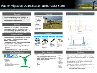
  • 1. Raptor Migration Quantification at the UMD Farm Lance Gauer | Dr. Gerald Niemi | Department of Biology | Natural Resources Research Institute | University of Minnesota Duluth • SAP (Sustainable Agriculture Project) • WindTech Inc. • 5 kW Turbine • 80 ft. structure • Self-Raising Tower • Zero Contact Transmission Technology -Magnet based turbine Purpose • To obtain baseline data on the movement of raptors near the UMD Farm, in light of a proposed wind turbine installation. Concern • Hawk Ridge in Duluth, MN is the 2nd largest migratory pathway in the country. With a wind turbine proposed to be installed here, there is a concern on mortality for these migrating raptors. Project Overview • Underwent training on Identification and the data entry process in mid August before I began research independently. • Completed 96 hours of observation between the dates of 9/7/2013 and 11/7/2013. • Observation start times ranged from 9am to 3:45 pm • Data were gathered in 1 hour increments Wind Turbine Project Materials Procedure Set Up -Set up Equipment -Enter Environmental Conditions Scan Identify -Scan 360 degree horizon. -Eyes 1st -Binoculars 2nd -Scope 3rd Record -Location -Assign Number -Flight direction -Name Data / Observations • What was recorded? • Height: 0=ground to canopy, 1=canopy-100m, 2=100m- 500m, 3=500m and above • Distance: 1=0-400m, 2=400m-800m, 3=800m-1200m, 4=1200m-1609m, 5=1609m-2414m. • Wind Speed & Direction • Temperature in degrees F • Sky • Visibility • Bird Results 50 45 40 35 30 25 20 15 10 5 Flight Height + Distance vs. Individuals Figure 1. Total # of individual raptors counted at the farm divided into the heights and distances they were observed at. 300 250 200 150 100 50 • Total # of raptors counted: 1012 • Estimated total # of raptors from 9/7/13-11/7/13: 4,117 Conclusion • In 96 hours of observation at the UMD farm 1,012 raptors were counted. The average flight height of these raptors according to our flight height numbering system was 1.57; approximately 200 ft, or 60 m high. And average distance from the point of observation was 2.19; approximately 480m. • Based on obtained data, we were able to estimate, using average # of raptors per hour, the total number of raptors that could have flown through the UMD farm area from the dates of 9/7/2013 to 11/7/2013. This estimation came out to be 4,117. • Considering raptors within the height range of 0-1 and distance range of 1 to be the raptors at highest risk of mortality from the 80 ft. turbine, we found 14.3% (145) of raptors within that range. • Using that same percentage applied to our estimated total # of raptors (4,117) it is estimated that approx. 590 raptors would have flown through the high-risk range of mortality between our dates of observation. -Flight Style/Behavior -Size and Shape - Wing angle • 10x42 Binoculars • Swarovski Scope • Deer Stand • w/Harness • Clip Board • Tripod • Compass • Thermometer • Pen • Warm Clothes • Field Guide 0 0 1 2 3 0 1 2 3 1 2 3 1 2 3 2 - (blank) 1 2 3 4 5 - (blank) Individuals Flight Height 0-3/Distance 1-5 - AK BE BE BW CG CH GE NG NH OS PF Raven RL RT SS TV UA UB UE UF UR (blank) Bird Codes • TV- Turkey Vulture • NH- Northern Harrier • OS- Osprey • BW- Broad Winged Hawk • RT- Red-tailed Hawk • RL- Rough-legged Hawk • BE- Bald Eagle • GE- Golden Eagle • SS- Sharp-Shinned Hawk • CH- Coopers Hawk • NG- Northern Goshawk • AK-American Kestrel • PG-Peregrine Falcon • UB-Unknown Buteo • UE- Unknown Eagle • UA- Unknown Accipiter • UF- Unknown Falcon • UR- Unknown Raptor 0 - AK BE BE BW CG CH GE NG NH OS PF Raven RL RT SS TV UA UB UE UF UR (blank) # of Individuals Individual Totals Figure 2. Total # of raptors in their individual amounts from all 96 hours of observation. • Bald Eagle: 254 • Red-tailed Hawk: 215 • Broad-winged Hawk: 128