SlideShare a Scribd company logo
1 of 2
Download to read offline
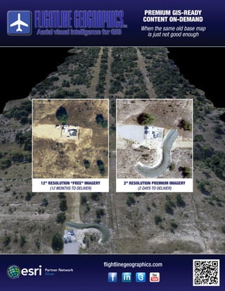
PREMIUM GIS-READY
CONTENT ON-DEMAND
When the same old base map
is just not good enough
12” RESOLUTION “FREE” IMAGERY
(12 MONTHS TO DELIVER)
2” RESOLUTION PREMIUM IMAGERY
(2 DAYS TO DELIVER)
flightlinegeographics.com
Flightline Geographics captures premium GIS-ready
content from both manned and unmanned platforms.
Never before has such high definition survey-grade
imagery been available with such short turn-around
times. Projects can be planned, captured and delivered
within days, instead of weeks or months, making near-
realtime monitoring of projects possible.
flightlinegeographics.com
Connect with us on social media for the latest news and information on UAS for GIS!
“GIS relies upon access to content. Flightline Geographics’ use of UAS
to capture, process and deliver GIS content in near real time is a real
game-changer.”
Esri President Jack Dangermond
Services are available world-wide and data can be delivered
through ArcGIS Online or traditional media.
Our online image content can be viewed along with your other
GIS map layers and users can navigate around on the map
using smartphones and tablets in the field!
Key Information:
• 1-2” resolutions are easily achievable
• 3D point cloud data produced from imagery
(.las format)
• Content is processed and delivered in days,
not weeks or months
• Affordable & repeatable throughout project
life cycle
• GIS-ready delivery via ArcGIS Online!
Trademarks provided under license from Esri. Copyright 2015 Flightline Geographics LLC

More Related Content

What's hot

Application of GIS in Flood Hazard Mapping - GIS I Fundamentals - CEI40 - AGA
Application of GIS in Flood Hazard Mapping - GIS I Fundamentals - CEI40 - AGAApplication of GIS in Flood Hazard Mapping - GIS I Fundamentals - CEI40 - AGA
Application of GIS in Flood Hazard Mapping - GIS I Fundamentals - CEI40 - AGAAhmed Gamal Abdel Gawad
 
QGIS Plugins - GIS II Advanced - CEI40 - AGA
QGIS Plugins - GIS II Advanced - CEI40 - AGAQGIS Plugins - GIS II Advanced - CEI40 - AGA
QGIS Plugins - GIS II Advanced - CEI40 - AGAAhmed Gamal Abdel Gawad
 
GIS and the Neogeographer
GIS and the NeogeographerGIS and the Neogeographer
GIS and the NeogeographerSchuyler Erle
 
Survey123 for Rural Telecom Fiber to the Home Selling
Survey123 for Rural Telecom Fiber to the Home SellingSurvey123 for Rural Telecom Fiber to the Home Selling
Survey123 for Rural Telecom Fiber to the Home SellingPaul Solsrud, PMP
 
How Neogeography Killed GIS
How Neogeography Killed GISHow Neogeography Killed GIS
How Neogeography Killed GISAndrew Turner
 
StevesDWESlide_exported
StevesDWESlide_exportedStevesDWESlide_exported
StevesDWESlide_exportedSteve Snow
 
Apps & web solutions with OpenSource - Mani Singh - IMIA Asia Pacific Conference
Apps & web solutions with OpenSource - Mani Singh - IMIA Asia Pacific ConferenceApps & web solutions with OpenSource - Mani Singh - IMIA Asia Pacific Conference
Apps & web solutions with OpenSource - Mani Singh - IMIA Asia Pacific ConferenceInternational Map Industry Association
 
Gis applications in civil engineering
Gis applications in civil engineeringGis applications in civil engineering
Gis applications in civil engineeringShanake Dissanayake
 
GIS for Transportation Infrastructure Management
GIS for Transportation Infrastructure ManagementGIS for Transportation Infrastructure Management
GIS for Transportation Infrastructure ManagementEsri
 
Location Intelligence for Everyone
Location Intelligence for EveryoneLocation Intelligence for Everyone
Location Intelligence for EveryoneJorge Sanz
 
gis project planning and management
gis project planning and managementgis project planning and management
gis project planning and managementAbhiram Kanigolla
 
GISDay2007 - Neogeography And Gis
GISDay2007 -  Neogeography And GisGISDay2007 -  Neogeography And Gis
GISDay2007 - Neogeography And GisAndrew Turner
 
From producers to consumers: democratizing the access to reference data
From producers to consumers: democratizing the access to reference dataFrom producers to consumers: democratizing the access to reference data
From producers to consumers: democratizing the access to reference dataJorge Sanz
 
Maximizing Benefits from Municipal GIS Operations The GIS Management Institu...
Maximizing Benefits from Municipal GIS Operations  The GIS Management Institu...Maximizing Benefits from Municipal GIS Operations  The GIS Management Institu...
Maximizing Benefits from Municipal GIS Operations The GIS Management Institu...Greg Babinski
 
Richard Leadbeater - Technology Solutions for Improved Service Delivery - GCS16
Richard Leadbeater - Technology Solutions for Improved Service Delivery - GCS16Richard Leadbeater - Technology Solutions for Improved Service Delivery - GCS16
Richard Leadbeater - Technology Solutions for Improved Service Delivery - GCS16KC Digital Drive
 

What's hot (20)

Application of GIS in Flood Hazard Mapping - GIS I Fundamentals - CEI40 - AGA
Application of GIS in Flood Hazard Mapping - GIS I Fundamentals - CEI40 - AGAApplication of GIS in Flood Hazard Mapping - GIS I Fundamentals - CEI40 - AGA
Application of GIS in Flood Hazard Mapping - GIS I Fundamentals - CEI40 - AGA
 
QGIS Plugins - GIS II Advanced - CEI40 - AGA
QGIS Plugins - GIS II Advanced - CEI40 - AGAQGIS Plugins - GIS II Advanced - CEI40 - AGA
QGIS Plugins - GIS II Advanced - CEI40 - AGA
 
Get Big Geo Data
Get Big Geo DataGet Big Geo Data
Get Big Geo Data
 
( G . i . s )
( G . i . s )( G . i . s )
( G . i . s )
 
GIS and the Neogeographer
GIS and the NeogeographerGIS and the Neogeographer
GIS and the Neogeographer
 
Survey123 for Rural Telecom Fiber to the Home Selling
Survey123 for Rural Telecom Fiber to the Home SellingSurvey123 for Rural Telecom Fiber to the Home Selling
Survey123 for Rural Telecom Fiber to the Home Selling
 
How Neogeography Killed GIS
How Neogeography Killed GISHow Neogeography Killed GIS
How Neogeography Killed GIS
 
StevesDWESlide_exported
StevesDWESlide_exportedStevesDWESlide_exported
StevesDWESlide_exported
 
Asset management with gis
Asset management with gisAsset management with gis
Asset management with gis
 
Apps & web solutions with OpenSource - Mani Singh - IMIA Asia Pacific Conference
Apps & web solutions with OpenSource - Mani Singh - IMIA Asia Pacific ConferenceApps & web solutions with OpenSource - Mani Singh - IMIA Asia Pacific Conference
Apps & web solutions with OpenSource - Mani Singh - IMIA Asia Pacific Conference
 
Geospatial trends
Geospatial trendsGeospatial trends
Geospatial trends
 
Gis applications in civil engineering
Gis applications in civil engineeringGis applications in civil engineering
Gis applications in civil engineering
 
GIS for Transportation Infrastructure Management
GIS for Transportation Infrastructure ManagementGIS for Transportation Infrastructure Management
GIS for Transportation Infrastructure Management
 
Location Intelligence for Everyone
Location Intelligence for EveryoneLocation Intelligence for Everyone
Location Intelligence for Everyone
 
gis project planning and management
gis project planning and managementgis project planning and management
gis project planning and management
 
GISDay2007 - Neogeography And Gis
GISDay2007 -  Neogeography And GisGISDay2007 -  Neogeography And Gis
GISDay2007 - Neogeography And Gis
 
From producers to consumers: democratizing the access to reference data
From producers to consumers: democratizing the access to reference dataFrom producers to consumers: democratizing the access to reference data
From producers to consumers: democratizing the access to reference data
 
Maximizing Benefits from Municipal GIS Operations The GIS Management Institu...
Maximizing Benefits from Municipal GIS Operations  The GIS Management Institu...Maximizing Benefits from Municipal GIS Operations  The GIS Management Institu...
Maximizing Benefits from Municipal GIS Operations The GIS Management Institu...
 
Richard Leadbeater - Technology Solutions for Improved Service Delivery - GCS16
Richard Leadbeater - Technology Solutions for Improved Service Delivery - GCS16Richard Leadbeater - Technology Solutions for Improved Service Delivery - GCS16
Richard Leadbeater - Technology Solutions for Improved Service Delivery - GCS16
 
Google Maps
Google MapsGoogle Maps
Google Maps
 

Similar to Flightline Geo Imagery Info Sheet

ArcGIS as a Platform
ArcGIS as a PlatformArcGIS as a Platform
ArcGIS as a PlatformGovLoop
 
2013 Geospatial Data and Project Management Track, Mobile Big Data by Genie Hays
2013 Geospatial Data and Project Management Track, Mobile Big Data by Genie Hays2013 Geospatial Data and Project Management Track, Mobile Big Data by Genie Hays
2013 Geospatial Data and Project Management Track, Mobile Big Data by Genie HaysGIS in the Rockies
 
ArcGIS: A Platform for Intelligent 3D Imagery
ArcGIS: A Platform for Intelligent 3D ImageryArcGIS: A Platform for Intelligent 3D Imagery
ArcGIS: A Platform for Intelligent 3D ImageryEsri
 
Arc news - Fall-2015
Arc news - Fall-2015Arc news - Fall-2015
Arc news - Fall-2015what3words
 
NDGISUC2017 - New Lidar Technologies for 3DEP
NDGISUC2017 - New Lidar Technologies for 3DEPNDGISUC2017 - New Lidar Technologies for 3DEP
NDGISUC2017 - New Lidar Technologies for 3DEPNorth Dakota GIS Hub
 
Introduction to Geographic Information System (GIS)
Introduction to Geographic Information System (GIS)Introduction to Geographic Information System (GIS)
Introduction to Geographic Information System (GIS)Shashank Singh
 
GIS and QGIS training notes
GIS and QGIS training notesGIS and QGIS training notes
GIS and QGIS training notesArnold Kilaini
 
GIS Use in Map, Chart, and Data Production
GIS Use in Map, Chart, and Data ProductionGIS Use in Map, Chart, and Data Production
GIS Use in Map, Chart, and Data ProductionEsri
 
Mago3D - An innovative AEC/GIS integration platform that can service millions...
Mago3D - An innovative AEC/GIS integration platform that can service millions...Mago3D - An innovative AEC/GIS integration platform that can service millions...
Mago3D - An innovative AEC/GIS integration platform that can service millions...SANGHEE SHIN
 
WEB GIS AND WEB MAP.pptx
WEB GIS AND WEB MAP.pptxWEB GIS AND WEB MAP.pptx
WEB GIS AND WEB MAP.pptxAsim Pt
 
Enhancing usability and utility of USGS 3D Elevation Program (3DEP) lidar dat...
Enhancing usability and utility of USGS 3D Elevation Program (3DEP) lidar dat...Enhancing usability and utility of USGS 3D Elevation Program (3DEP) lidar dat...
Enhancing usability and utility of USGS 3D Elevation Program (3DEP) lidar dat...OpenTopography Facility
 

Similar to Flightline Geo Imagery Info Sheet (20)

Geoinformatics handbook
Geoinformatics handbookGeoinformatics handbook
Geoinformatics handbook
 
ArcGIS as a Platform
ArcGIS as a PlatformArcGIS as a Platform
ArcGIS as a Platform
 
My ppt on gis
My ppt on gisMy ppt on gis
My ppt on gis
 
2013 Geospatial Data and Project Management Track, Mobile Big Data by Genie Hays
2013 Geospatial Data and Project Management Track, Mobile Big Data by Genie Hays2013 Geospatial Data and Project Management Track, Mobile Big Data by Genie Hays
2013 Geospatial Data and Project Management Track, Mobile Big Data by Genie Hays
 
ArcGIS: A Platform for Intelligent 3D Imagery
ArcGIS: A Platform for Intelligent 3D ImageryArcGIS: A Platform for Intelligent 3D Imagery
ArcGIS: A Platform for Intelligent 3D Imagery
 
A revolution for a better management
A revolution for a better managementA revolution for a better management
A revolution for a better management
 
GEMS_Article_PetroleumNews
GEMS_Article_PetroleumNewsGEMS_Article_PetroleumNews
GEMS_Article_PetroleumNews
 
Geospatial Product Watch 2015
Geospatial Product Watch 2015Geospatial Product Watch 2015
Geospatial Product Watch 2015
 
Mrp Intrim
Mrp IntrimMrp Intrim
Mrp Intrim
 
Arc news - Fall-2015
Arc news - Fall-2015Arc news - Fall-2015
Arc news - Fall-2015
 
GIS PPT
GIS PPTGIS PPT
GIS PPT
 
NDGISUC2017 - New Lidar Technologies for 3DEP
NDGISUC2017 - New Lidar Technologies for 3DEPNDGISUC2017 - New Lidar Technologies for 3DEP
NDGISUC2017 - New Lidar Technologies for 3DEP
 
Introduction to Geographic Information System (GIS)
Introduction to Geographic Information System (GIS)Introduction to Geographic Information System (GIS)
Introduction to Geographic Information System (GIS)
 
CV-RAKESH KUMAR
CV-RAKESH KUMARCV-RAKESH KUMAR
CV-RAKESH KUMAR
 
GIS and QGIS training notes
GIS and QGIS training notesGIS and QGIS training notes
GIS and QGIS training notes
 
GIS Use in Map, Chart, and Data Production
GIS Use in Map, Chart, and Data ProductionGIS Use in Map, Chart, and Data Production
GIS Use in Map, Chart, and Data Production
 
Mago3D - An innovative AEC/GIS integration platform that can service millions...
Mago3D - An innovative AEC/GIS integration platform that can service millions...Mago3D - An innovative AEC/GIS integration platform that can service millions...
Mago3D - An innovative AEC/GIS integration platform that can service millions...
 
WEB GIS AND WEB MAP.pptx
WEB GIS AND WEB MAP.pptxWEB GIS AND WEB MAP.pptx
WEB GIS AND WEB MAP.pptx
 
5_6102463055130527018.pdf
5_6102463055130527018.pdf5_6102463055130527018.pdf
5_6102463055130527018.pdf
 
Enhancing usability and utility of USGS 3D Elevation Program (3DEP) lidar dat...
Enhancing usability and utility of USGS 3D Elevation Program (3DEP) lidar dat...Enhancing usability and utility of USGS 3D Elevation Program (3DEP) lidar dat...
Enhancing usability and utility of USGS 3D Elevation Program (3DEP) lidar dat...
 

Flightline Geo Imagery Info Sheet

  • 1. PREMIUM GIS-READY CONTENT ON-DEMAND When the same old base map is just not good enough 12” RESOLUTION “FREE” IMAGERY (12 MONTHS TO DELIVER) 2” RESOLUTION PREMIUM IMAGERY (2 DAYS TO DELIVER) flightlinegeographics.com
  • 2. Flightline Geographics captures premium GIS-ready content from both manned and unmanned platforms. Never before has such high definition survey-grade imagery been available with such short turn-around times. Projects can be planned, captured and delivered within days, instead of weeks or months, making near- realtime monitoring of projects possible. flightlinegeographics.com Connect with us on social media for the latest news and information on UAS for GIS! “GIS relies upon access to content. Flightline Geographics’ use of UAS to capture, process and deliver GIS content in near real time is a real game-changer.” Esri President Jack Dangermond Services are available world-wide and data can be delivered through ArcGIS Online or traditional media. Our online image content can be viewed along with your other GIS map layers and users can navigate around on the map using smartphones and tablets in the field! Key Information: • 1-2” resolutions are easily achievable • 3D point cloud data produced from imagery (.las format) • Content is processed and delivered in days, not weeks or months • Affordable & repeatable throughout project life cycle • GIS-ready delivery via ArcGIS Online! Trademarks provided under license from Esri. Copyright 2015 Flightline Geographics LLC