2. OBJECTIVES:
Load Temporal Based Imagery (LandSat4-5)
Enhance for Vegetation
Use ArcGIS to Classify Change
Present Areas of Change, specifically New Agriculture
Equate New Area of Agrculture
Possibly Equate Water Use by Majority of Crop Type
3. CONCERNS AND ISSUES
Glacier and Rock Glacier
Retreat
Increase Water Flow
Increased Agriculture
Water Scarcity
4. Downloaded
LandSat 4-5
Imagery:
March
1989, &
2010
NDVI Images:
1989-2010
RasterClip:
Extreme
Spectral
Change
NDVI of
1989 Image
Subset
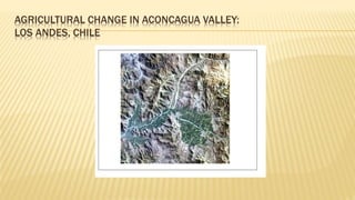
Images of Los
Andes Chile:
1989-
2010
Subset
Imagery
Raster Clip:
1989 Polygon
FeatureClass
From
ReclassRastC
al1
Create
NDVIs
Images of
1989-2010
using Image
Analysis tool:
Arc GIS
Create Personal
GDB and Polygon
Feature Class, and
Digitize Agricultural
Area
Raster
Calculator:
2010 NDVI –
1989 NDVI
Reclassify
:30 – 81:
1
Rest =
NoData
New Agricultural/
Extreme Spectral
Change
Polygon
Shapefile of
Agricultural
Area: 1989
RastCal1
7. NORMALIZED DIFFERENCE VEGETATION INDEX
Contrasts Near Infra-Red Spectal Band From
Visible Spectral Bands 1,2,3
(Near IR – Visible)
(Near IR + Visible)
NDVI =
9. CHANGE DETECTION
30 – 81: Extreme Change
-2 -10 : Little to No Change
-95 - -20: Different type of Extreme
Change
Mountains to Agricultural
Agricultural to Urban
Different Crop types
15. FINAL ANALYSIS IF THIS IS ALL WINE GRAPES
44251 New Pixel at (30 x 30 meters) = 9598 acres
High Yield Vineyard can produce 7200 Bottles per Acre
Low Yield Vineyard can produce 1440 Bottles per Acre
One Bottle of Wine uses and estimated 620 liters of water
892,800 liters of water per Acre per Low Yield Vineyard