Headings - 2010 issue 2
•
0 likes•158 views

Continental Mapping used satellite imagery from DigitalGlobe's WorldView-1 satellite to create detailed 2-foot contours and volumetric surveys of a coal stockpile for an energy company. Their analysis was within 1% of an independent analysis using traditional aerial photogrammetry. Continental Mapping also welcomed a congresswoman to discuss support for small businesses and federal mapping efforts.

Recommended
Recommended
More Related Content
What's hot
What's hot (19)
Viewers also liked
Similar to Headings - 2010 issue 2
More from Headings
More from Headings (15)
Recently uploaded
Recently uploaded (20)
Headings - 2010 issue 2
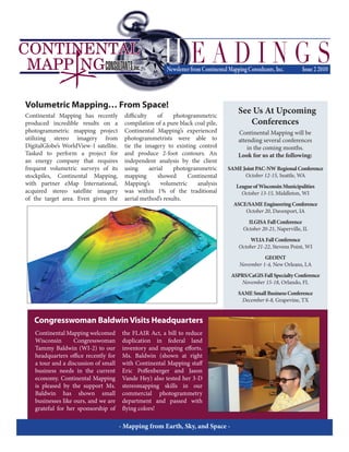
- 1. Continental Mapping has recently produced incredible results on a photogrammetric mapping project utilizing stereo imagery from DigitalGlobe’s WorldView-1 satellite. Tasked to perform a project for an energy company that requires frequent volumetric surveys of its stockpiles, Continental Mapping, with partner eMap International, acquired stereo satellite imagery of the target area. Even given the difficulty of photogrammetric compilation of a pure black coal pile, Continental Mapping’s experienced photogrammetrists were able to tie the imagery to existing control and produce 2-foot contours. An independent analysis by the client using aerial photogrammetric mapping showed Continental Mapping’s volumetric analysis was within 1% of the traditional aerial method’s results. Volumetric Mapping… From Space! - Mapping from Earth, Sky, and Space - Continental Mapping welcomed Wisconsin Congresswoman Tammy Baldwin (WI-2) to our headquarters office recently for a tour and a discussion of small business needs in the current economy. Continental Mapping is pleased by the support Ms. Baldwin has shown small businesses like ours, and we are grateful for her sponsorship of the FLAIR Act, a bill to reduce duplication in federal land inventory and mapping efforts. Ms. Baldwin (shown at right with Continental Mapping staff Eric Poffenberger and Jason Vande Hey) also tested her 3-D stereomapping skills in our commercial photogrammetry department and passed with flying colors! Congresswoman BaldwinVisits Headquarters See Us At Upcoming Conferences Continental Mapping will be attending several conferences in the coming months. Look for us at the following: SAMEJointPAC-NWRegionalConference October 12-15, Seattle, WA LeagueofWisconsinMunicipalities October 13-15, Middleton, WI ASCE/SAMEEngineeringConference October 20, Davenport, IA ILGISAFallConference October 20-21, Naperville, IL WLIAFallConference October 21-22, Stevens Point, WI GEOINT November 1-4, New Orleans, LA ASPRS/CaGISFallSpecialtyConference November 15-18, Orlando, FL SAMESmallBusinessConference December 6-8, Grapevine, TX
- 2. For further information on these features or general inquiries, please contact: Continental Mapping Consultants, Inc. Wisconsin Office Sun Prairie, WI 608.834.9823 phone Indiana Office Plainfield, IN 317.244.1800 phone Oregon Office Portland, OR 503.430.0230 phone info@continentalmapping.com www.continentalmapping.com ContinentalMappingConsultants,Inc. 121S.BristolStreet,Suite201 SunPrairie,WI53590 RETURNSERVICEREQUESTED or general inquiries, please contact: Continental Mapping Consultants, Inc. Wisconsin Office Sun Prairie, WI Fall flying season is here! Portland, OR 503.430.0230 phone info@continentalmapping.com www.continentalmapping.com Please contact us immediately to schedule your mapping project! PRSTSTD USPostage PAID MadisonWI Permit#1