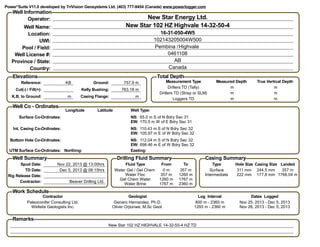
1. Well Information
Operator: New Star Energy Ltd.
Well Name: New Star 102 HZ Highvale 14-32-50-4
Location: 16-31-050-4W5
UWI: 102143205004W500
Pool / Field: /HighvalePembina
Well License #: 0461108
Province / State: AB
Country: Canada
Elevations
Reference: KB
Cut(-) / Fill(+):
K.B. to Ground: m
Ground: 757.9 m
Kelly Bushing: 763.18 m
Casing Flange: m
Total Depth
Measurement Type
Drillers TD (Tally)
Drillers TD (Strap or SLM)
Loggers TD
Measured Depth
m
m
m
True Vertical Depth
m
m
m
Well Co - Ordinates
Longitude Latitude Well Type:
NS:
EW:
Surface Co-Ordinates: 65.0 m S of N Bdry Sec 31
170.5 m W of E Bdry Sec 31
NS:
EW:
Int. Casing Co-Ordinates: 110.43 m S of N Bdry Sec 32
105.97 m E of W Bdry Sec 32
NS:
EW:
Bottom Hole Co-Ordinates: 112.04 m S of N Bdry Sec 32
698.46 m E of W Bdry Sec 32
UTM Surface Co-Ordinates: Northing: Easting:
Well Summary
Spud Date: Nov 22, 2013 @ 13:00hrs
TD Date: Dec 5, 2013 @ 08:15hrs
Rig Release Date:
Contractor: Beaver Drilling Ltd.
Drilling Fluid Summary
From
0 m
Fluid Type
Water Gel / Gel Chem
To
357 m
357 mWater Floc 1260 m
1260 mGel Chem Water 1767 m
1767 mWater Brine 2360 m
Casing Summary
Type
Surface
Hole Size
311 mm
Casing Size
244.5 mm
Landed
357 m
Intermediate 222 mm 177.8 mm 1766.04 m
Work Schedule
Contractor
Paleoconifer Consulting Ltd.
Geologist
Genaro Hernandez, Ph.D.
Log Interval
800 m - 2360 m
Dates Logged
Nov 25, 2013 - Dec 5, 2013
Wellsite Geologists Inc. Oliver Orjionwe, M.Sc Geol. 1293 m - 2360 m Nov 26, 2013 - Dec 5, 2013
Remarks
New Star 102 HZ HIGHVALE 14-32-50-4 HZ TD
Power*Suite V11.0 developed by TriVision Geosystems Ltd. (403) 777-9454 (Canada) www.powerlogger.com
2. Slide - Rotate S S S S S S S S S S S SDrillingProgress
GR2(gapi)
050100150
GammaRay(gapi)
050100150
TotalGas(units)
07501500
DrillRate(min/m)
051015
051015
07501500
050100150
Measured Depth
1640 m 1660 m 1680 m 1700 m 1720 m 1740 m
55.4
ostss
91.2
nrdg
15.5
bnf
Wellpath,Tops,Lithology
ActualTopBanff(m)
1615160515951585
WellPath(m)
1615160515951585
TVDTargetPath(m)
1615160515951585
TopBanff-Prognosis(m)
1615160515951585
1615160515951585
62.06°
A
Z
93.43°
64.89°
A
Z
92.59°
64.89°
A
Z
92.59°
67.85°
A
Z
91.84°
67.85°
A
Z
91.84°
70.58°
A
Z
92.27°
70.58°
A
Z
92.27°
73.4°
A
Z
92.09°
73.4°
A
Z
92.09°
75.43°
A
Z
92.49°
75.43°
A
Z
92.49°
78.12°
A
Z
92.81°
78.12°
A
Z
92.81°
80.1°
A
Z
92.16°
80.1°
A
Z
92.16°
81.25°
A
Z
92.36°
81.25°
A
Z
92.36°
82.76°
A
Z
91.98°
82.76°
A
Z
91.98°
84.73°
A
Z
91.15°
84.73°
A
Z
91.15°
86.5°
A
Z
92.05
86.5°
A
Z
92.05
8787
1615160515951585
DOL: lt - m brn, mnr wh, micxl - v f xln, rexld,
wi dol rhmbs, suc, bit thru, pyr dism & locly,3-
15% vis intgr & mic vugy por, g o stng, g pets
od, g cut, g cut flor. Mnr SH lam, gn, dk, sbfis,
micmica, calcs, w ind.
DOL:
xln, rex
tr wh do
mic vug
od, g b
Ostracod Sandstone
(TVD: 1582.37)
(SSL: -819.19)
Nordegg
(TVD: 1593.07)
(SSL: -829.89)
Banff Clarks Member
(TVD: 1597.48)
(SSL: -834.30)
Measured Depth
1640 m 1660 m 1680 m 1700 m 1720 m 1740 m
55.4
ostss
91.2
nrdg
15.5
bnf
Rounding a a a a a a a a a a a a
Sorting M M M M M M M M M M M
Grain Size
c slt
vf snd
f snd
m snd
c snd
Interpreted Lithology
P
P
m m
P P
P
PP m m P
m m
P
m m
m m
m m
P
P P
P
P
Porosity (%)
20
15
10
5
Porosity Type X X X X X X X X X X X X X X X X X X X X X XX X XXXV VV V
Oil Shows
Date
3. S S S S S S S S
Bit#3 VAREL U513S
1410.00 / 29.5 hrs
Cond --I
NB#4 J & L FDTBit#4 J & L FDT
0.10 / 0.1 hrs
Cond --I
NB#5 Drillformance DF513T2 FOB= 7-18
RPM= S/33
SPM= 130
PP= 9824
DNS= 1095
VIS= 30
pH= 11
051015
07501500
050100150
1760 m 1780 m 1800 m 1820 m 1840 m 1860 m 1880
67
icp
1615160515951585
1615160515951585
87.28°
A
Z
91°
88.02°
A
Z
88.52°
88.02°
A
Z
88.52°
88.39°
A
Z
87.28°
88.39°
A
Z
87.28°
89.43°
A
Z
86.39°
89.43°
A
Z
86.39°
91.24°
A
Z
86.09°
91.24°
A
Z
86.09°
91.81°
A
Z
87.57°
91.81°
A
Z
87.57°
92.38°
A
Z
88.2°
92.38°
A
Z
88.2°
92.55°
A
Z
89.9°
92.55°
A
Z
89.9°
92.96°
A
Z
91.14°
92.96°
A
Z
91.14°
93.69°
A
Z
92.98°
93.69°
A
Z
92.98°
91.38°
A
Z
92.08°
91.38°
A
Z
92.08°
90.94°
A
Z
92.96°
90.94°
A
Z
92.96°
90.7°
A
Z
91.95°
90.7°
A
Z
91.95°
OL: lt - m brn, brnsh gy ip, micxl - v f
n, rexld / dol rhmbs, suc, com bit thru,
wh dol / pyr locly, 10 - 24% vis intgr &
mic vugy por, even lt brn o stng, g pets
d, g blsh wh cut, g cut flor.
Bleed off pump# 1 @ 1784m
LS: lt gy - off wh, slly mot brn, p -
mnr o stng, crpxl - micxl, dolic,
cht grs, tt -12 % vis intxl por.
DOL: lt - m brn, brnsh gy ip, micxl - v f xln,
rexld / dol rhmbs, suc, bit thru, tr wh dol / pyr
locly, 8 - 25% vis intgr & mic vugy por, even lt
brn o stng, g pets od, g blsh wh cut, g cut flor.
DOL: lt - m brn, micxl - v f xln, re
rhmbs, suc, bit thru, tr wh dol / p
25% vis intgr & mic vugy por, ev
stng, g pets od, g blsh wh cut, g
LS aa.
Intermediate Casing
(TVD: 1601.49)
(SSL: -838.31)
1760 m 1780 m 1800 m 1820 m 1840 m 1860 m 1880
67
icp
P
P
P
P
P
P
P PP P P P
P
P
X XV V X VV X V X XV V X VX X V X X X X VX X X XV V X X VV X XVV X V V V V VX X X X PP
Nov 30 Dec 3, 2013
4. S S S S
FOB= 2-11
RPM= S/32
SPM= 130
PP= 10115
DNS= 1085
VIS= 32
pH= 11
051015
051015
07501500
07501500
050100150
050100150
880 m 1900 m 1920 m 1940 m 1960 m 1980 m 2000 m
1615160515951585
1615160515951585
1615160515951585
1615160515951585
91.95°
90.94°
A
Z
91.5°
90.94°
A
Z
91.5°
89.5°
A
Z
91.59°
89.5°
A
Z
91.59°
89.6°
A
Z
89.93°
89.6°
A
Z
89.93°
89.19°
A
Z
90.06°
89.19°
A
Z
90.06°
88.15°
A
Z
89.5°
88.15°
A
Z
89.5°
88.22°
A
Z
88.96°
88.22°
A
Z
88.96°
87.99°
A
Z
88.9°
87.99°
A
Z
88.9°
88.36°
A
Z
88.36°
88.36°
A
Z
88.36°
90.07°
A
Z
88.72°
90.07°
A
Z
88.72°
91.07°
A
Z
88.65°
91.07°
A
Z
88.65°
91.31°
A
Z
89.24°
91.31°
A
Z
89.24°
90.8°
A
Z
89.46°
90.8°
A
Z
89.46°
90.2°
A
Z
90.16°
90.2°
A
Z
90.16°
91.41°
A
91.41°
A
xln, rexld / dol
dol / pyr locly, 12 -
por, even lt brn o
cut, g cut flor. Tr.
DOL: lt - m brn, micxl - v f xln, rexld / dol rhmbs,
suc, bit thru, tr wh dol / pyr locly, 13 - 25% vis
intgr & mic vugy por, even lt brn o stng, g pets od,
g blsh wh cut, g cut flor. Tr. LS strgs.
DOL: lt - m brn, micxl - v f xln, rexld / dol
rhmbs, suc, bit thru, tr wh dol / pyr locly, 8 -
25% vis intgr & mic vugy por, even lt brn o
stng, g pets od, g blsh wh cut, g cut flor. Tr.
SH strgs aa.
880 m 1900 m 1920 m 1940 m 1960 m 1980 m 2000 m
P
P
P
P
P
P
P P
P
P P P
P
X X X XVVVV X XV X X X XVVVV X X XVVV V V V V V V V V V VP P P PX X X X X X X X X X
5. S S S S
FOB= 2-11
RPM= S/32
SPM= 131
PP= 4645
DNS=
1090
VIS= 30
pH= 10.5
Cycle pumps for MWD
051015
07501500
050100150
2020 m 2040 m 2060 m 2080 m 2100 m 2120 m 2140 m
1615160515951585
1615160515951585
91.41°
A
Z
91.43°
91.58°
A
Z
91.43°
91.58°
A
Z
91.43°
90.1°
A
Z
90.02°
90.1°
A
Z
90.02°
89.5°
A
Z
89.01°
89.5°
A
Z
89.01°
89.63°
A
Z
88.78°
89.63°
A
Z
88.78°
89.43°
A
Z
88.56°
89.43°
A
Z
88.56°
90.4°
A
Z
89.3°
90.4°
A
Z
89.3°
90.37°
A
Z
89.42°
90.37°
A
Z
89.42°
89.13°
A
Z
88.84°
89.13°
A
Z
88.84°
89.13°
A
Z
89.02°
89.13°
A
Z
89.02°
88.83°
A
Z
88.05°
88.83°
A
Z
88.05°
89.8°
A
Z
87.32°
89.8°
A
Z
87.32°
91.17°
A
Z
87.22°
91.17°
A
Z
87.22°
92.02°
A
Z
87.73°
92.02°
A
Z
87.73°
DOL: lt - m brn, tr - mnr wh dol, micxl - v f
xln, rexld / dol rhmbs, suc, bit thru, pyr locly,
11 - 25% vis intgr & mic vugy por, even lt
brn o stng, g pets od, ex blsh wh cut, g cut
flor. Tr SH strgs.
DOL: lt - m brn, tr - mnr wh dol,
micxl - v f xln, rexld / dol rhmbs,
suc, bit thru, pyr locly, 11 - 25% vis
intgr & mic vugy por, even lt brn o
stng, g pets od, ex blsh wh cut, g
cut flor.
LS: lt gy - off wh, slly mot brn, p -mnr
o stng, crpxl - micxl, dolic, mnr cht grs,
tt -12 % vis intxl por.
2020 m 2040 m 2060 m 2080 m 2100 m 2120 m 2140 m
P
P
P
P
P
P
P
P
P
V VX X XXX XXXX X X X XXX X X XXVVV VVV VVV VVV V VV X V X XV X V
Dec 4, 2013
6. S S S S S S
FOB= 5-16
RPM= S/31
SPM= 131
PP= 10545
DNS= 1090
VIS= 30
pH= 10
FOB= 19-25
RPM= S/32
SPM= 131
PP= 9044
DNS= 1095
VIS= 32
pH= 10
051015
07501500
050100150
40 m 2160 m 2180 m 2200 m 2220 m 2240 m 2260 m
1615160515951585
1615160515951585
Z
87.73°
92.45°
A
Z
89.38°
92.45°
A
Z
89.38°
91.94°
A
Z
90.29°
91.94°
A
Z
90.29°
91.21°
A
Z
93.3°
91.21°
A
Z
93.3°
92.65°
A
Z
94.69°
92.65°
A
Z
94.69°
91.88°
A
Z
95.56°
91.88°
A
Z
95.56°
90.2°
A
Z
93.96°
90.2°
A
Z
93.96°
89.16°
A
Z
94.13°
89.16°
A
Z
94.13°
88.09°
A
Z
92.62°
88.09°
A
Z
92.62°
87.62°
A
Z
91.41°
87.62°
A
Z
91.41°
88.56°
A
Z
91.35°
88.56°
A
Z
91.35°
89.66°
A
Z
92.05°
89.66°
A
Z
92.05°
90.3°
A
Z
91.42°
90.3°
A
Z
91.42°
90°
A
Z
91.05°
90°
A
Z
91.05°
91.04°
A
91.04°
A
grs,
DOL: lt - m brn, tr wh dol, micxl - v f xln, rexld /
dol rhmbs, suc, bit thru, pyr locly and dism, 12
- 25% vis intgr & mic vugy por, even lt brn o
stng, g pets od, g blsh wh cut, g cut flor. Tr SH
stringers aa.
DOL: lt - m brn, tr - mnr wh dol, micxl - v f
xln, rexld / dol rhmbs, suc, bit thru, pyr locly
and dism, 12 - 25% vis intgr & mic vugy
por, even lt brn o stng, g pets od, g blsh wh
cut, g cut flor. Tr SH stringers aa.
LS: lt gy - off wh, slly m
mnr o stng, crpxl - micx
mnr cht grs, tt -12 % vi
40 m 2160 m 2180 m 2200 m 2220 m 2240 m 2260 m
P
P
P
P P
P
P P
P P P
VX X V X XV X X X XVVVV VV V V V VXXXX X X X X X VX X V X V X V
7. S S Slide - Rotate
Bit#5 Drillformance DF513T2
592.80 / 43.5 hrs
Cond --I
051015
07501500
050100150
GR2(gapi)
050100150
GammaRay(gapi)
050100150
TotalGas(units)
07501500
DrillRate(min/m)
051015
DrillingProgress
2280 m 2300 m 2320 m 2340 m 2360 m
60
td
Measured Depth
1615160515951585
1615160515951585
91.04°
A
Z
91.39°
91.14°
A
Z
90.37°
91.14°
A
Z
90.37°
91.11°
A
Z
90°
91.11°
A
Z
90°
91.48°
A
Z
89.37°
91.48°
A
Z
89.37°
92.48°
A
Z
88.96°
92.48°
A
Z
88.96°
93.05°
A
Z
88.81°
93.05°
A
Z
88.81°
92.45°
A
Z
90.03°
92.45°
A
Z
90.03°
90.2°
A
Z
89.5°
90.2°
A
Z
89.5°
89.09°
A
Z
88.21°
89.09°
A
Z
88.21°
88°
A
Z
88.21°
, slly mot brn, p -
- micxl, dolic,
2 % vis intxl por.
DOL: lt gy - m brn, tr wh dol, micxl - v f xln, rexld / dol
rhmbs, suc, bit thru, pyr locly and dism, 10 - 25% vis
intgr & mic vugy por, even lt brn o stng, g pets od, g
blsh wh cut, g cut flor. Mnr SH strgs aa. Tr LS strg aa.
TD @ 2360m MD, Dec 5, 2013 @ 8:15 hrs
Total Depth
(TVD: 1597.07)
(SSL: -833.89)
ActualTopBanff(m)
1615160515951585
WellPath(m)
1615160515951585
TVDTargetPath(m)
1615160515951585
TopBanff-Prognosis(m)
1615160515951585
Wellpath,Tops,Lithology
2280 m 2300 m 2320 m 2340 m 2360 m
60
td
Measured Depth
Rounding
Sorting
Grain Size
c slt
vf snd
f snd
m snd
c snd
P
P
P
P
P P P
P
P
P
P P
P
P P
Interpreted Lithology
Porosity (%)
20
15
10
5
XV V XV X V X V X V X V V X X X X X X X XV V V V V Porosity Type
Oil Shows
Dec 5, 2013 Date