1. Improving coverage and updating of GPS velocities in Southern California
David Guenaga, Gareth Funning and Nader Shakibay-Senobari
Introduction
Despite improvements in continuous GPS station coverage in Southern
California over the past decade, several areas including the Ventura basin,
Elsinore fault, and central San Jacinto fault have been identified as areas with
limited existing GPS coverage. In this campaign we aim to increase GPS
coverage and update GPS velocities in southern California by measuring new
and previously measured sites.
Objective
In this continuing project we aim to expanding GPS coverage and obtain new
GPS measurements in Southern California. In this way, our estimates of
velocities can be updated and their precisions improved, ultimately providing
better constraints on fault slip rates. We plan to archive the data produced in
the UNAVCO Campaign Data archive so that it may be readily available for the
SCEC community, for incorporation in the Community Geodetic Model, and for
use by other geoscientists in the future.
Methods
• During the planning stage, we obtained the coordinates of previously
measured sites and various potential new sites for GPS measurement.
• Sites were then selected by considering their ease of access, site’s integrity
and the need for additional/updated GPS measurements in those areas.
• With Information from the National Geodetic Survey and various
geocachers/benchmark-hunters, we were able to effectively evaluate and
locate new benchmarks for survey.
• Once sites were identified and located, we deployed survey-grade GPS
equipment at them for a minimum of 8 hours, and in most cases for 18-24
hours.
Results
In this campaign over 40 sites were visited and 37 sites were measured. Of
these measured sites, 30 were previously measured and 7 previously
unmeasured sites. Sites that were visited but not measured were either
destroyed, tampered with, or not found. Some planned sites were also
unattainable due to physical barriers (i.e. fences, damaged roads). Sites that
were measured relatively recently and located considerably farther were also
not measured due to time constraints. With the use of GAMIT software, newly-
collected data was processed for all 37 sites. This processed data will eventually
be further processed with GLOBK software to produce velocity estimates for
these sites.
Conclusion
This campaign is part of a continuing project that will continue on to measure
sites in the Ventura basin and Elsinore fault area. During this campaign, we
were able to update and further increase the density of the GPS coverage of the
San Jacinto fault area. We were also able to process most of the data collected
to eventually produce an updated GPS velocity map.
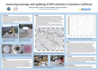
Figure 1: Geodetic equipment set up
at site BERN with a survey grade
tripod.
Figure 2: Geodetic equipment
set up at site BEFT with a spike
mount.
Figure 3: Types national geodetic survey bench markers found and measured in
the field. From left to right, the markers are from the following sites BEFT, BOWN,
and 0822.
University of California, Riverside, Riverside, CA
Figure 5: Timeline plot of the sites measured by UCR campaigns.
Figure 4: Map of area surveyed during this campaign. Lines represent the major
faults in the area.
Figure 6: Field photos of us setting up the GPS equipment at site BEFT (right image)
and recording information at site WALN (left image).
Year
Site
Acknowledgements
This work was supported by the SCEC Summer Undergraduate Research
Experience internship program and through the SCEC award #15198.