2012 BISHOP Interpretation and modelling of the Pedirka Basin using magnetics, gravity, well-log and seismic data
•
2 likes•164 views


Recommended
Recommended
More Related Content
What's hot
What's hot (20)
Viewers also liked
Viewers also liked (15)
Similar to 2012 BISHOP Interpretation and modelling of the Pedirka Basin using magnetics, gravity, well-log and seismic data
Similar to 2012 BISHOP Interpretation and modelling of the Pedirka Basin using magnetics, gravity, well-log and seismic data (20)
2012 BISHOP Interpretation and modelling of the Pedirka Basin using magnetics, gravity, well-log and seismic data
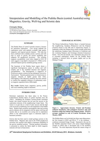
- 1. 22 nd International Geophysical Conference and Exhibition, 26-29 February 2012 - Brisbane, Australia 1 Interpretation and Modelling of the Pedirka Basin (central Australia) using Magnetics, Gravity, Well-log and Seismic data Christopher Bishop Geosoft Australia Pty Ltd 14/100 Railway Road, Subiaco, Western Australia Also: Centre for Petroleum Geoscience, The University of Western Australia christopher.bishop@geosoft.com INTRODUCTION Petroleum exploration has taken place in the Permo- Carboniferous Pedirka Basin of central Australia since the 1950’s. Straddling the Northern Territory/South Australian border, this remote location has not seen the success or the exploration intensity of the neighbouring Cooper basin. The reason is in part due to a lack of early success and the high costs involved in mobilising crew and equipment to the Pedika basin. Modern high resolution aeromagnetic data and existing gravity datasets can be integrated with the sparse well-log and seismic data as an excellent cost saving tool to exploration efforts in the underexplored region to determine depth to basement estimates. Gravity data has been used to model geology sections in the Pedirka basin. Magnetic data used in the VOXI geophysical inversion tool assisted with depth to basement modelling of the gravity modelled sections. Thermal gradient information is presented to outline the likely depth at which magnetic minerals will start to break down. GEOLOGICAL SETTING The Permo-Carboniferous Pedirka Basin is located between the neighbouring Amadeus (Palaeozoic) and the Simpson (Triassic) basins to the NW and E respectively (Figure 1). Sediments within the Pedirka basin extents include strata from the underlying Amadeus basin (Devonian to Cambrian) and the overlying Simpson and Eromanga (Jurassic-Cretaceous) basins. Over the last decade, new information has given rise to reworked sedimentary models for the Pedirka Basin including a renewed focus on greater depths and on the Madigan Trough. Figure 1. Approximate Jurassic, Triassic and Permian sediment boundaries with geological structures and well locations within the Pedirka and Simpson basins. EP/EPA acreages (outlined in red) of Central Petroleum. (from Meaney, 2009) The Pedirka Basin can be divided into three main depocentres; the first located in EP93 and PELA 77 is the northeast – southwest orientated Eringa Trough. Separated to the east by the McDills Anticlinal Trend is the saucer shaped Madigan Trough (in EP93) that is developed only in the Northern Territory. The third depocentre beyond the eastern fringe of SUMMARY The Pedirka Basin of central Australia remains a frontier for petroleum exploration. Cost saving methods for exploration exists with publicly available high quality magnetics and regional gravity datasets. This data has been combined with available seismic sections and well logs to assist in gravity 2D section modelling and magnetic 3D geophysical inversions. The resulting magnetic susceptibility voxel when clipped to 0.012 SI units suggests a top depth to basement of ~5500m on the selected Simpson gravity modelled geology section. The basement of the Pedirka basin region shows a significant heterogeneous nature in surface and well samples and in the modelled densities and magnetic susceptibilities. The heterogeneity is suggestive of Proterozoic granite systems having undergone convective fractionation. Thermal gradients point to a break down in magnetic minerals at depths greater than 15km. Outcropping of the Mereenie sandstone has been utilised to confirm the negligible influence of sedimentary units on magnetic signatures below 600m depth. Key words: Pedirka basin, magnetics, gravity, profile and voxel modelling, depth to basement.
- 2. Interpretation and Modelling of the Pedirka Basin using Magnetics, Gravity Christopher Bishop 22 nd International Geophysical Conference and Exhibition, 26-29 February 2012 - Brisbane, Australia 2 the Pedirka border is the Northern Poolowanna Trough which falls outside the scope of this paper. The oldest sediments of the Amadeus and Warburton Basins were deformed during the Alice Springs Orogeny (ASO) (395- 325 Ma) and perhaps by the earlier Delamerian Orogeny (510- 476 Ma) (Radke, 2009). The Mid to Late Carboniferous ASO was a NW-SE compressional phase creating structures such as occur along the McDills Trend – a series of NNE-SSW trending thrust faults, east of and sub-parallel to the Eringa Trough (Figure 1). The Madigan Trough interrupts this trend. Following the ASO, the Pedirka sediments were subsequently deposited in a tectonically inactive sag phase and are preserved across the (McDills Trend) ridge linking the Eringa and Madigan troughs. A subsequent compressional episode in early to late Permian resulted in tilting (to the South East), uplift and erosion of the western Pedirka Basin (Hibburt and Gravestock, 1995). A simplified stratigraphic succession of the Amadeus, Pedirka and Simpson basins is shown in Figure 2. Figure 2: Simplified Chrono-stratigraphy of Amadeus-, Pedirka- and Simpson basins (Gibson et al. 2005). GEOPHYSICAL SETTING Magnetic and Gravity data collected from the Geophysical Archive Data Delivery System (GADDS), was gridded, stitched and processed for interpretation and modelling (Bishop, 2010). Gridded results of the Free air Gravity is shown in Figure 3. Noteworthy aspects include outcropping porphyritic adamellite and granitic basement to the west and gneiss to the north of the basin (Abminga and Finke 1:250000 map sheets respectively) in the location of high free air gravity values. Hale River 1 encountered minor volcanics (Basalt flows, feldspathic dykes, andisitic sills) and sediment conglomerates at relatively shallow depths of 1430m suggesting the cause of the gravity high. The SW to NE trending gravity low delineates reasonable well the Eringa trough due to the sub-linear depocentre of sediments. Total Magnetic Intensity data was gridded at 100m cell size and reduced to pole. The resulting grid in Figure 4 is purposely shown as blank to the south East. This null area has no magnetic data except in grid form, with vastly poorer resolution and quality to the collected magnetic data. As a result it has not been included. Figure 3. Gridded free air Gravity data. Showing gravity stations as black crosses. Pedirka Basin outline in black. Areas marked A and B indicate crystalline basement outcrops of Precambrian gneiss, granite, adamellite – A as part of Arunta Block, B as part of Musgrave block. . Figure 4. Reduced to pole, gridded Total Magnetic Intensity at 100m cell size. Showing key well positions, depocentres (troughs), and geological structures. Mereenie sandstone profile line marked. Sedimentary Unit Magnetic Signature at Depth The Mereenie sandstone (Silurian) of the Amadeus basin extends into the Pedirka basin sediment stack and is bounded to the west by the Mt Hammersley, Dalmatia thrust Fault and to the east by the Purni Fault (Figure 4). This unit outcrops to the north of the Pedirka basin providing one of the best sedimentary unit magnetic signatures of the region – though subtle enough such that an Analytic Signal of the TMI best defines the signature. A profile was taken perpendicular to
- 3. Interpretation and Modelling of the Pedirka Basin using Magnetics, Gravity Christopher Bishop 22 nd International Geophysical Conference and Exhibition, 26-29 February 2012 - Brisbane, Australia 3 this unit (shown in Figure 5) to show its analytic signal signature at surface, and simulated depths of 300m and 600m through upward continuation. Figure 5: i) Mereenie SS outcrop profile location over the 1:250000 Rodinga Geological sheet (left image) and over the RTP analytic signal of TMI (right image). See also Figure 4. ii) Profiles at indicated upward continued heights with marked outcrop locations A, B and C of 5 i). At 600m depth, this signature becomes negligible and thus can be concluded that the magnetic signatures of the Pedirka basin overwhelmingly represent changes in the character of the (granitoid) basement. Thermal Gradient, Curie Point and Magnetic Signature Thermal depth gradient information was collected from well completion reports of Mt Hammersley 1, Dalmatia 1, Purni 1, Glen Joyce 1, Macumba 1, Erabena 1, Walkandi 1 and Poolowanna 1 wells. The thermal gradient down to approximately 2.5km subtly increases west to east across the basin from ~38-42°C/km.. The curie point at which rocks lose magnetic properties takes place at ~550 °C (Telford et al. 1990). Although thermal conductivity in the substrata may change at greater depths, there is no such data at present and thus a figure of 38°C/km was used to estimate the breakdown of magnetic minerals in the Pedirka basin at depths of approximately 15km. Hence magnetic signatures are expected to be above this depth and have been modelled as such. INTERPRETATION AND MODELLING Gravity Profile Modelling Gravity modelling has been carried out in order to estimate the depth to basement and to assess the density of the basin sediments and of the basement. Interval velocities and two way times were used from Mt Hammersley 1 and Dalmatia 1 seismic calibration logs. Key sedimentary horizons were traced with assistance from the time based 2D seismic sections and converted to a depth section. Interval velocities were confirmed by matching the down hole horizon depths. Densities for key stratigraphic units from well completion reports were then used in modelling to the free-air gravity signal. Numerous sections have been modelled however only the Simpson profile will be discussed here. Ellipsoid Free Air anomaly values have been used with the “air block” of the model set as 0.0 g/cm3 . The Simpson profile marked in Figure 3 starts to the NW and extends SE 88km to the Simpson 1 well which was used as a tie point. The resulting model is shown in Figure 6. The observed/calculated gravity signals are a very good fit overall. Of note is a discrepancy between the observed and calculated gravity signal from km 16 to km 30 of the profile. The dataset used for gridding has no gravity stations in this interval nor in the immediate vicinity. It is therefore possible the minimum curvature gridding algorithm may have interpolated incorrectly the observed signal in this area – accounting for the error. Magnetic Voxel Geophysical Inversion The Geosoft VOXI geophysical inversion was used on TMI data in order to arrive at a 3-dimensional voxel representation of the magnetic susceptibility. The overall area was divided into smaller pieces for inversion - with the trend removed for each grid prior to inversion. Voxels were merged after inversion having a resolution of 600m, 600m, 200m for X, Y, Z cell sizes respectively over ~48,000 km2 and to an inversion depth of 17km. The resulting voxel shown in Figure 7 has been used to help define the basement depth of the Simpson gravity modelled profile. Combining the inversion and gravity modelled profile information suggests the heterogeneous nature of the basement perhaps associated with the granite systems having undergone convective fractionation during their creation (Wyborn, 2001). CONCLUSIONS Sedimentary units have no effect on magnetic signatures in the Pedirka basin below 600m depth. New insight has been gained into the depths to magnetic basement of the Pedirka basin and has been utilised in refining gravity modelled sections down to depths not reached by seismic data or by wells. Magnetic inversion and Gravity profile modelling have illustrated the heterogeneous nature of the basement in both density and magnetism as perhaps related to multiple granite bodies having undergone convective fractionation. Modelled top depths to basement in the Simpson profile was ~5.5km. ACKNOWLEDGMENTS Special thanks go to Central Petroleum for kindly providing NT well information and seismic data otherwise unobtainable. REFERENCES Bishop, C., 2010, Gridding Techniques and Qualitative Assessment of Sediment Thickness using Magnetics over the Pedirka Basin (central Australia). ASEG Extended Abstracts 2010, 1-4. DOI:10.1071/ASEG2010ab150 Gibson HJ, Duddy IR, Ambrose GJ and Marshall TR, 2005. Regional perspectives on new and reviewed thermal history data from central Australian basins: in Northern Territory Geological Survey (editors). Symposium handbook. Central Australian Basins Symposium: Petroleum and minerals potential. Alice Springs, 16–18 August 2005, 22.
- 4. Interpretation and Modelling of the Pedirka Basin using Magnetics, Gravity Christopher Bishop 22 nd International Geophysical Conference and Exhibition, 26-29 February 2012 - Brisbane, Australia 4 Hibburt, J.E. and Gravestock, D.I, 1995. Pedirka Basin. In Drexel, J.F. and Preiss, W.V. (Eds). The geology of South Australia. Volume 2, The Phanerozoic. South Australia Geological Survey Bulletin, 54, 88-90. Meaney, R.A., 2009. A Review of the Potential for Underground Coal Gasification and Gas to Liquids Applications in EP’s 93, 97, 105, 106 & 107 and EPA’s 130 & 131 Pedirka Basin, Onshore Northern Territory and Pela 77 Pedirka Basin Onshore South Australia: Mulready Consulting Services Pty. Ltd Report dated 5/6/2009. Radke, B, 2009, Hydrothermal & Geothermal Prospectivity of Sedimentary Basins in Central Australia: Geoscience Australia, Record 2009/25. Telford, W. M., Geldart, L. P., Sheriff, R. E., 1990, Applied geophysics, second edition: Cambridge University Press. Wyborn, L.A.I., 2001 - Granites and copper gold metallogenesis in the Australia Proterozoic. In Budd, A.R., Wyborn, L.A.I. and Bastrakova, I.V. The Metallogenic potential of Australian Proterozoic granites. Australian Geological Survey Organisation, Record 2001/12. Figure 6 (above): Simpson geological section initially modelled on velocities while in time domain (not shown) and then modelled on density while in depth domain. Yellow shaded strata from Eromanga basin (early Cretaceous to early Jurassic), pink strata from Pedirka basin (Permian / Carboniferous), green/blue strata from Amadeus basin (Devonian to Cambrian). Simpson 1 well depths marked. Observed and calculated gravity signal in upper profile. D: Density g/cm3 . V=Velocity m/s. Figure 7: 3D image showing dark grey magnetic susceptibility clipped to 0.012 (SI units) after the geophysical voxel inversion of TMI magnetic data. Reduced to pole magnetics pseudocolour grid is displayed on a base plane at 17km bsl. Pedirka basin outline in black. The Simpson gravity modelled section (from Figure 6) is displayed showing blue low to red high density. 3D cursor is at 5,550m b.s.l. marking postulated top depth to basement. Diagonal map extent is ~350km.