
Recommended
Recommended
More Related Content
Featured
Featured (20)
Rejoinder to the news published on reclassification of land in Nandhambakkam village
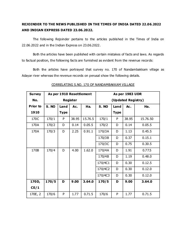
- 1. REJOINDER TO THE NEWS PUBLISHED IN THE TIMES OF INDIA DATED 22.06.2022 AND INDIAN EXPRESS DATED 23.06.2022. The following Rejoinder pertains to the articles published in the Times of India on 22.06.2022 and in the Indian Express on 23.06.2022. Both the articles have been published with certain mistakes of facts and laws. As regards to factual position, the following facts are furnished as evident from the revenue records: Both the articles have portrayed that survey no. 170 of Nandambakkam village as Adayar river whereas the revenue records on perusal show the following details. CORRELATING S.NO. 170 OF NANDAMBAKKAM VILLAGE Survey No. Prior to 1910 As per 1910 Resettlement Register As per 1983 UDR (Updated Registry) S. NO Land Type Ac. Ha. S. NO Land Type Ac. Ha. 170C 170/1 P 38.95 15.76.5 170/1 P 38.95 15.76.50 170A 170/2 D 0.14 0.05.5 170/2 D 0.14 0.05.5 170A 170/3 D 2.25 0.91.1 170/3A D 1.13 0.45.5 170/3B D 0.37 0.15.1 170/3C D 0.75 0.30.5 170B 170/4 D 4.00 1.62.0 170/4A D 1.91 0.77.5 170/4B D 1.19 0.48.0 170/4C1 D 0.30 0.12.5 170/4C2 D 0.30 0.12.0 170/4C3 D 0.30 0.12.0 170D, CE/1 170/5 D 9.00 3.64.0 170/5 D 9.00 3.64.0 170E, 2 170/6 P 1.77 0.71.5 170/6 P 1.77 0.71.5
- 2. 2. Contrary to the claim of the articles that the survey no. 170C of Nandhambakkam village as per the 1912 record is Adyar river in an extent of 38.95 Acre, the survey no. 170/1 with an extent of 38.95 acres (15.765 hectare) is only mentioned as Adayar river in the Revenue records of the year 1912. Similarly, as per 1912 records the S. No. of 170/6 with an extent of 0.71.5 Ha. (1.77 Acre) is also mentioned as Adayar river. Both the survey no. 170/1 and 170/6 with their extent continue to be as poramboke land (Adayar river) from prior to 1910 to till date as per Revenue records. The other survey nos. 170/2, 170/3, 170/4 and 170/5 were only classified as punjai (Dry land) and patta has been issued to the individuals. 3. M/s. Blue Nile Properties private limited applied for a Planning Permission to CMDA for the reclassification of land use for an extent of 6.00 Acres in New S.No. 170/10, 11, 12 & 13, Old S.No.170/5A1 part, of Nandambakkam Village, Alandur Taluk, Chennai District, from Water body to Residential Use Zone for developing a residential building at the site under reference. As per the Second Master Plan for Chennai Metropolitan Area approved by the Government on 02.09.2008, the said land has been classified as water body as it lies adjacent to the Adyar River. The Master Plans are usually prepared assigning the land uses with reference to whole survey numbers only subdivisions are not taken into account. Therefore, the entire survey no. 170 of Nandambakkam village was classified as water body due to the presence of Adayar river. 4. As per the revenue records furnished by the applicant, the site under reference was a part of the extent of 3.64.0 Ha. in S. No. 170/5 situated in Nandambakkam and belonged to one Thiru. Sivarama Iyer. The name of Thiru.Sivarama Iyer is reflected in the 1983 Nandambakkam UDR Register (‘A’ Register) against S.No. 170/5 (Patta No.119). Earlier also as per the ‘A’ register (1910) the old survey number 170/5 is shown as a patta land in favour of Thiru. Munusami Mudhali and Thiru. Ethirajalu Chettiyar. Subsequently, the part of the land comprised in S.No.170/5 has been sub-divided, sold to many and these sub-divisions have been carried out by the Revenue Department in the FMB sketch.
- 3. CORRELATING STATEMENT S.NO. 170/5 OF NANDAMBAKKAM VILLAGE Survey No As per 1983 UDR (Updated Registry) S. NO Land Type Ha. Total in Ha. 170/5 170/5A1 D 3.06.0 3.64.0 170/5A2 D 0.28.0 170/5A3 D 0.14.0 170/5A4 D 0.14.0 170/5A5 D 0.02.0 170/5A1 170/5A1A D 2.93.0 3.06.0 170/5A1B D 0.13.0 170/5A1A 170/5A1A1 D 2.75.0 2.93.0 170/5A1A2 D 0.06.0 170/5A1A3 D 0.02.0 170/5A1A4 D 0.10.0 170/5A1A1 170/5A1A1 Part D 2.54.2 2.75.0 170/7 D 0.07.6 170/8 D 0.06.6 170/9 D 0.06.6 170/5A1A1 Part 170/5A1A1 Part D 0.14.0 2.54.2 170/10 D 0.20.0 170/11 D 0.20.0 170/12 D 0.20.0 170/13 D 1.80.2
- 4. 5. As per the copy of sale deed document furnished by the applicant, it could be seen thatThiru. SivaramaIyyar during 1952 (328/1952) purchased part of land from old survey no. 170/5 from VedhagiriMudhaliyar and others. Further after demise of Thiru. SivaramaIyyar, the legal heirs of viz., Thiruvalargal S. Ramani, V. Meenakshi and S. Santha nominated Thiru N. G. Karunanathi as general power of attorney for them in document no. 153/2002. The General power of attorney ThiruKarunanathi sold the site under reference to M/s. Blue Nile properties in vide document numbers 567/2005, 581/2005, 707/2004 and 628/2005. 6. The site under reference surrounded by 30 feet mud road and vacant land on the northern side, large parcel of vacant land beyond which OTA campus exist on the southern side, existing shed/ vacant land followed by ground + first floor & ground + second floor buildings on the eastern side and retaining wall followed by the adayar river on the western side. 7. The reclassification proposals are examined under section 32(4) & 33 (3) of Tamil Nadu Town & Country Planning Act – 1971. During scrutiny of reclassification proposals the factors such as the ownership of the property, suitability of the site, accessibility, compatibility with the adjoining existing / proposed developments, existence of adjoining / nearby water bodies, impact of the environment are taken into account. 8. In this regard, the Public Works Department (PWD) furnished remarks on inundation point of view with certain terms and conditions, and the Tahsildar, Alandur furnished remarks stating that the site under reference is not an encroached property and the boundaries were measured. Also, the Superintending Engineer, GCC furnished remarks on the above proposal. Further an inspection by a team of senior officials from the Revenue department, CMDA, PWD have inspected the site and the report is awaited. The above said reclassification proposal is being examined based on as per rules in force.