1. Towards Topographically
Sensitive Urbanism
Re-envisioningearthworkterracinginsuburbandevelopment
Karl Kullmann
2014, Journal of Urbanism 8 (4): 331–351
Introduction: topographic defiance
Celebrated world cities sited on or near steep topography respond to
their settings with a variety of site-specific strategies. In Hong Kong,
slopes of up to 40% gradient are typically built on, with steeper
ground artificially stabilized and classified within an engineering
database (Figure 2). In Rio de Janeiro, the almost vertical megalithic
granite domes serve as spatial and religious orienting devices that are
circumnavigated by the official city and appropriated by the favelas.
In Sydney, arterial roads tend to track the ridgelines that alternate
with forested valleys, with vestiges of exposed sandstone penetrating
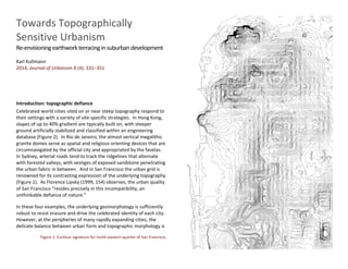
the urban fabric in between. And in San Francisco the urban grid is
renowned for its contrasting expression of the underlying topography
(Figure 1). As Florence Lipsky (1999, 154) observes, the urban quality
of San Francisco “resides precisely in this incompatibility, an
unthinkable defiance of nature.”
In these four examples, the underlying geomorphology is sufficiently
robust to resist erasure and drive the celebrated identity of each city.
However, at the peripheries of many rapidly expanding cities, the
delicate balance between urban form and topographic morphology is
Figure 1. Contour signature for north-eastern quarter of San Francisco.
2. Figure 2. Example of a Hong Kong “registered slope” stabilization technique
disrupted. In California, the supply of relatively level land in Los
Angeles and the Bay Area has largely been exhausted, with both
metropolitan areas abutting their mountainous frames (SCSC 2001,
2). Unperturbed by this topographic barrier and facilitated by mining-
scale “mountain cropping” techniques (after Bronson 1968, 35),
suburban sprawl increasingly encroaches into the peripheral foothills
(Figure 3). In the southern hemisphere, the naturally undulating sand
dune terrain of Perth (Western Australia) does not hinder the rapid
suburban expansion of the metropolitan area. The dunes are
stripped of all vegetation and remodelled into megalithic ‘benched’
earthworks of retaining walls and perfectly flat building lots, thus
creating a blank canvas that enables the ‘great suburban dream’ to be
pursued irrespective of the natural topography of the site (Figures 4
and 5).
Figure 3. Example of site preparation for new suburban development at Hayward,
California.
3. Figure 4. Example of remodelling undulating sand dune terrain into a large
earthwork of retaining walls (demarcated by their shadows) and perfectly flat
buildings lots to facilitate rapid suburban expansion in Perth, Australia. 2012.
Figure 5. 12 ft (3.5m) high retaining walls in preparation for residential subdivision
in northern Perth. Indigenous remnant heath vegetation and natural topographic
landform is visible in the background.
Three urban models:
modernism, ecological planning, traditional urban design
From both ecological and urban design perspectives, the examples
outlined above frame a flawed template for metropolitan growth.
Nonetheless, the three prevailing twentieth century urban models
have exerted little influence over the process of mechanized
suburban transformation. First, modern urbanism sought to
reconstitute cities above the ground on pilotis designed to enable the
land to flow unimpeded beneath (Vogt 2000). Although successful in
isolated projects, when realized on a large scale in post-WWII
reconstruction in Europe and urban renewal in the US, decoupling
from the ground often had the unintended by-product of devaluing
the landscape. The pastoral scenes of many modern visions
degenerated into wastelands in the absence of custodians to share
and steward the ground. As a result, automobiles routinely
appropriated the uncoordinated landscape between and beneath
buildings that offered lack of gathering spaces to support urban life
(Ingersoll 2006). Consequences included environmental degradation
and the dissolution of functioning communities (see Jacobs 1961;
Sennett 1990).
Second, ecological planning—as embodied in the ‘suitability analysis’
techniques developed by Ian McHarg (1969)—was more repellent,
dictating where development should not occur, such as on steep
slopes. An influential McHargian image that illustrates dispersed fully
detached housing co-inhabiting a sparsely wooded valley slope clearly
demonstrates the environmental limitations McHarg placed on
development in particular landscape types (Figure 6). While
appropriate in some contexts, given the contemporary pressures on
cities to expand it is nevertheless unlikely that every steep slope will
be protected from suburban development. In these instances
ecological planning methods risk becoming less effectual once the
anti-development argument has been lost.
4. Third, the currently prevalent model of traditional urban design
focuses on reinstating the key formal qualities of pre-modern
urbanism. This model is premised on the massing of built form and
landmarks, and the legibility of streets as they relate to networks of
both movement and lines of sight. As cities were generally
historically sited on waterways, traditional urbanism is most
efficacious on flat sites. Where it does exist, topography is often
positioned in urban design schemes as a non-urban ‘other’ that takes
the form of a park or natural landmark. The seminal Rural-Urban
Transect diagram by Andrés Duany (2002) illustrates this point. The
schematic section taken from the core of a city to the periphery is
entirely flat, with topography conveniently relegated to the periphery
of the built zones and identified as regional recreational and nature
reserves (Figure 7). Although useful as a historical analysis, this
idealized model does not accurately reflect conditions at the
peripheries of many expanding contemporary cites. As Peter
Bosselmann (2011) demonstrates, actual urban cross-sectional
profiles reveal a far more complex relationship between topography,
urban morphology and urban legibility than a flat urban core
encircled by a hilly wooded periphery. In coastal cities in particular,
the appeal of building near the coast—despite typically offering
steeper topography than inland river flood plains—further dissolves
neat topographically-based urban/rural distinctions.
Figure 6. Illustration of low-density development suitable for sloped woodlands as
established through Ian McHarg’s suitability analysis. Source: McHarg, I. (1969)
Design with Nature. Garden City, NY: Natural History Press, p. 90.
Figure 7. Rural–urban transect illustrating assumption of flat urban core and hilly
wooded periphery. Source: Duany, A. (2002) Introduction to the Special Issue: The
Transect. Journal of Urban Design 7(3), p. 256.
Research aims, methods and definitions
Modernism, ecological planning, and traditional urban design provide
robust urban models for many aspects of cities. These include
organizing urban cores, conserving areas of ecological value,
maximizing community interaction, and integrating infrastructure.
Nevertheless, there is limited research within the disciplines
concerned with the design qualities of cities into the role of
topography in enhancing urbanism. Although numerous researchers
and observers have identified the troublesome nature of suburban
expansion into hilly terrain, these concerns tend to emerge as a by-
product of other research in specific disciplinary arenas, including
history, biology, ecology, landscape architecture, architecture, urban
planning, and urban design. Responses tend to be polarized between
the implicit position that this kind of development should be stopped
altogether, and site-specific experiments that address individual
typological situations in isolation from the overall urban structure. As
cities continue to expand due to population growth and may need to
retreat to higher ground due to the impacts of climate change,
developing a more holistic framework becomes increasingly
important.
5. To create a contextualizing framework, the article synthesizes
relevant perspectives and methods from the range of disciplines that
are invested—either through opposition or participation—in the
practice of suburban benching on steep sites. The argument for
fostering more topographically responsive suburban design is
structured in three parts: (1) outlining the post-WWII transformations
that have driven the suburban benching phenomenon; (2) articulating
the inherent worth of retained topographic form; and (3) examining
how the key building blocks of suburbia may be reinterpreted to
achieve more topographically responsive suburban morphologies.
The article includes analysis of examples from Perth (Western
Australia) and the Bay Area (California), both of which exhibit
significant expansion into distinct types of hilly terrain.
Although Australian suburban growth is more controlled than the US
development model (Troy 1996; Gleeson 2006), the engineered
benching morphology that typically results is similar. In both
California and Western Australia, suburban benching is constructed
across average hillside gradients ranging anywhere from of between
2% and 30%. Localized slopes within the original landform of up to
75% the foothills of the Bay Area, and 70% in the sand dunes of Perth,
are typically smoothed out during the re-grading process. Within this
very wide gradient range, slope does not impact the prevalence or
general engineering of suburban benching, with only the relative
height of the retaining walls or embankments between lots increasing
in proportion to steepness. On slopes averaging above 30%,
suburban benching remains uncommon, with low-density pile/stilt
construction housing forming the dominant housing type on very
steep slopes in the Bay Area. In Perth, long slopes averaging over
30% are rare and generally not developed for suburban housing. In
addition to the influence of slope, suburban benching ranges in scale
from an area as small as two residential lots, through to the
development of entire suburbs of 150 lots in the Bay Area and over
500 lots in Perth.
Figure 8. Longji (Dragon's Backbone) Terraced Rice Fields, Guangxi, China.
Framing the problem: levelling the ground
Levelling out an area of ground when establishing a camp represents
a primeval act of inhabitation; for eons levelness has allowed humans
to gather readily around a cooking fire and to sleep comfortably. The
act of cutting and filling does not erase or create earth but rather
carves functionality from the ruggedness of the world. Indeed, the
very notion of levelness equates to usability across a very wide range
of programs that encompass dwelling, making, agriculture and
recreation (Figure 8). Conversely, land that is out-of-level has tended
to be perceived as useless and is thus attributed lower, or merely
scenic, value. Interestingly, differentiating the ruggedness of wild
terrain from the cultivated usability of the terrace represents a
relatively contemporary dichotomy, with ‘terrain’ and ‘terrace’
actually sharing equivalent etymological origins (Leatherbarrow
2004).
6. Throughout history, levelness is equally important in the founding of
cities. Roman surveyors typically preferred sites on flood plains, and
the Groma (Roman survey apparatus) was plumbed to sit
perpendicular to the level ground, with this vertical orientation a
precondition of the accurate functionality of the instrument (see
Rykwert 1976, 50). Even in instances where urbanism was
topographically sited primarily for defence—as in the case of the
southern European medieval hill towns that followed the withdrawal
of Roman stability, and the Incas’ retreat at Machu Picchu (Peru)—
levelness was still a determining factor, albeit in heavily restricted
proportions atop knolls or cols. On this need and capacity to create
levelness in even the most extreme environments, landscape theorist
Anne Whiston Spirn (1984, 91) termed humans “geological agents.”
Spirn observed that the topography of settlements is constantly
modified as “hills are levelled” and “low-lying basins are filled.”
Constructing level sites in even the most precipitous settings is thus a
timeless activity in inhabitation, agriculture and the building of
civilizations. The incorporation of ‘making level’ into benched
suburban site-works may therefore be interpreted as historically
consistent. In order to differentiate site terracing on a suburban scale
from historical types of levelling, the following section identifies the
convergence of factors driving the emergence of suburban benching.
1. Lack of available flat land
The exhaustion of flat land suitable for building contributes pressure
to develop steep terrain that had previously been considered off-
limits due to the prohibitive cost-engineering challenges of preparing
this land for development (see Corner and MacLean, 67). This
process is more complex than internal population increases exerting
pressure on ‘full’ cities to expand outwards, since a concurrent
reduction in residential densities at the metropolitan core often
accompanies growth at the peripheries of cities. This ‘hollow-city’
phenomenon can take several forms. At one extreme is the highly
visible socio-economic retreat from inner-suburban blight that
characterizes many US cities to varying degrees. At the other, is the
subtler but nevertheless statistically powerful process of
gentrification. As occurs in all major Australian cities, socio-economic
displacement results in a reduction in numbers of residents per
dwelling in first-ring suburbs.
Both blight and gentrification displace residents and services to the
periphery, even before the pressure of actual overall population
increase is considered (Bruegmann 2005). In this context, on-going
planning and design initiatives to revitalize potential infill areas within
existing urban boundaries represent an essential component of
sustainable cities. Nevertheless, while some observers place hope in
the capacity for “genuine centre-based diversity and density” to
contain sprawl and “stop ecologically destructive growth at the edge”
(Fishman 2006, 3), it appears unlikely that urban infill will
accommodate all of a given city’s future population increases. By
extension, peripheral green-fields expansion—that in many instances
impinge into steep terrain—is likely to be an inevitable condition of
twenty-first century urbanism that requires management through
sustainable design and planning techniques (Gleeson 2006, 10).
2. Growth in building footprints
The floor areas of single-family fully detached dwellings increased
markedly after WWII. In Australia, typical floor areas of around 1,000
sq ft (90m2
) in the 1940s grew to 1,600 sq ft (150m2
) by the mid-
1980s, and further to 2,300 sq ft (210m2
) by the mid-2000s (Hall
2007). In the US, house sizes increased from an average of 1,000 sq ft
(90m2
) after WWII, to 2,400 sq ft (220m2
) by 2010 (Sarkar 2011). On
both continents, this expansion represents a more than doubling of
living space in just half a century. Throughout this period, larger
dwellings have been marketed as necessary to accommodate the
post-WWII prosperity-driven culture of lifestyle features that include
chef’s-kitchens, activity-rooms, home-theatres, and large foyers
(Flanagan 1998). The simultaneous reduction in actual numbers of
inhabitants per dwelling mirrored the increase in physical living space.
7. In the US, average household size shrank from 4.60 people per house
in 1900, to 3.68 in 1940, and 2.59 in 2000 (Hobbs and Stoops 2002).
Similarly, in Australia, average households declined from 4.6 people
per dwelling a century ago, to 3.6 people in the 1950s, 2.6 in 2006,
and are expected to decline further to 2.4 by 2031 (de Vaus 2004;
ABS 2010).
3. Shrinkage of building lot sizes
A proportional reduction in average lot sizes compounded the
marked historical increase in the footprints of suburban housing. In
Australia, typical single-family residential lots decreased from 11,000
sq ft (1020m2
) in the 1930s, to 8,000 sq ft (740m2
) in the 1950s, 6,000
sq ft (560m2
) in the 1970s, and down to 4,500 sq ft (420m2
) in the
2000s, with some single family residential ‘cottage’ lots below 2,500
sq ft (230m2
) (Kupke et al. 2011). In the US, lot shrinkage has not
been as dramatic, but has nonetheless been decreasing since
reaching a maximum average of 14,000 sq ft (1,300m2
) in the 1990s
(Sarkar 2011). The initial period of downsizing from large ¼ acre lots
can be attributed to the widespread installation of sewage
infrastructure, which eliminated the need for spatially extensive
onsite septic tanks. Smaller lots also provided the higher yields
necessary to offset increased development costs associated with
installing sewers. Following the initial impact of sewage systems, the
decrease in building lot sizes can also be ascribed to both supply and
demand. On the supply side, the exponential increase in land values
in many cities has been connected to increased access to credit that
reached a peak in before the Global Financial Crisis of 2008, but
originates in the returned serviceman home loans that were a feature
of both US and Australian post-WWII societies (Morris 2005, 186;
Hayden 2004, 4; Chow 2002, 22–25). The trend towards smaller lots
partially offsets the affordability issues associated with increases in
the cost of land. On the demand side, increased preferences for
indoor and offsite leisure activities improved the marketability of ‘low
maintenance’ smaller lots.
4. Plot coverage ratios and indoor/outdoor continuity
The net result of expanding dwellings and shrinking lots has been an
increase in plot coverage ratios (percentage of a lot covered by
buildings). In Australia plot ratios rose from as low as 10% on the ¼
acre (1020m2
) lots that were typical prior to WWII, to 60% and above
in the 2000s (Hall 2007). Increased plot ratios substantially diminish
the quantity of un-built land available on individual lots for
negotiating differences in topography. Three archetypal situations
from the undulating topography of the Perth suburban fabric
illustrate this point. In a typical 1940s situation, the generous
proportions of the lot, diminutive footprint of the dwelling, and lack
of ‘lifestyle’ programming for the yard left ample space for
accommodating the natural landform (Figure 9a). In most instances,
the dwelling was set above the lay-of-the-land on a plinth constructed
either of timber stilts, or a cut-limestone block foundation that
precisely traced the footprint of the house. Additionally, the
positioning of the house was frequently fine-tuned to the localized
topography of the site by rotating or shifting the footprint away from
the street.
By the 1960s, burgeoning floor areas and decreasing lot sizes required
more proactive site-based solutions to the challenges posed by slopes
(Figure 9b). Terraced retaining walls set back from property
boundaries emerged as a technique for facilitating increased demand
for flat outdoor entertaining areas set level with the internal floor of
the house. With origins in Californian modernism, the popularization
of fluid leisure space between indoors and outdoors represented a
significant shift in attitudes that continues to influence present-day
suburban design. Within this new architectural paradigm, the garden
came to be viewed as an extension of the house, displacing the old
arrangement of the house constituted as an internal private world set
between a decorative front garden and functional backyard. Split-
level floor plates also became a common feature in dwellings of this
era, with the change in level demarcating living and entertaining
areas within the house, but also having the additional advantage of
8. Figure 9. Axonometric diagrams illustrating the affect of shrinking suburban lots and
growing house areas on landform treatment with regards to steep sites:
(a) 1940s 1,250 sq ft (120m2) house on 8,000 sq ft (740m2) lot with site grade
negotiated using a limestone plinth foundation for house.
(b) 1970s 1,750 sq ft (160m2) house on 6,000 sq ft (560m2) lot with site grade
negotiated using a combination of split level construction, external retaining walls,
and terraces near property boundaries.
(c) 2000s 2,500 sq ft (230m2) house on 4,500 sq ft (420m2) lot with site grade
negotiated using retaining walls on all property boundaries to create level lot.
accommodating any changes in site topography within the footprint
of the building.
In many suburban developments through the 1990s and into the
2000s, expanding building footprints and shrinking lots surpassed the
critical threshold of plot coverage ratios of 50-60%. At this point, the
relationship between house and land fundamentally inverted from a
house set within a lot to the lot constituted as a narrow buffer around
the house. In this new standard, the lot plays a supporting role to the
house, essentially taking over the function of the building foundations
typical of the 1940s. In hilly locations, the site grade is negotiated
using retaining walls that have been displaced outwards to the
property boundaries so as to create a perfectly level lot (Figure 9c). In
a logical evolution of this practice, the retaining walls became the
official demarcation of the parcel boundaries, replacing the role of six
ft. high boundary fences found in older suburbs. This in turn
necessitated an infrastructural-scaled approach to site preparation
that differs markedly from the piecemeal homeowner-scaled
operations that characterized site manipulation up until the 1980s.
The effects of these transformations on the post-WWII suburban
landscape are clearly illustrated in a series of topographic samples
taken from the Perth suburban fabric. In each 500m (1640 ft.)
squared frame, the contour signature of the suburban residential
area is compared with adjacent terrain that has been preserved in its
natural state (Figure 10). In a 1940s development, the large lots,
small building footprints, and compact building foundation plinth,
leave the underlying landform virtually unmodified. In a similar 1950s
development on a very steep slope, repositioning houses within the
lots minimized contour manipulation. In a 1970s development
undergoing renewal with backyard infill development, a moderate
degree of topographic modification and some retaining walls are
evident. In a 2000s development, the indigenous landform has been
totally substituted for an artificial landscape of terracing and retaining
walls.
5. Technology and standardized models
In economic terms, increased land values and more efficient mining-
scale earth-moving techniques to allowed formerly unprofitable sites
to be levelled for suburban development. Additionally, the post-
WWII shift to mass-produced concrete slab ‘tract homes’ and
superficially customized ‘model homes’ necessitated that suburban
residential development sites be standardized to accommodate pre-
determined buildings, as opposed to the buildings adapting to the
site. With origins in the late-1940s planned community of Levittown
(Long Island, New York), this culture of mass production reflects the
same top-down models associated with product manufacture.
9. Figure 10. 500m (1640 ft) square samples of four suburbs with adjacent unmodified
landform covering the left portion of each plot. Top row includes topographic,
cadastral, and building footprint data. The topographic signature for each square is
isolated on the bottom row:
(a) 1940s development (Nedlands) showing underlying landform virtually
unmodified.
(b) 1950s development (Mt Claremont) showing some calibration of building
footprint within lots on steepest slopes.
(c) 1970s development (North Beach) with some infill development underway
showing moderate contour modification.
(d) 2000s development (Kinross) showing total substitution of indigenous landform
with artificial terracing.
10. Initially, the developer of a given suburban project identifies their
potential market, defines the lifestyles around which the identity of
the project will be created, and finally programs the site to fulfil this
vision (Chow 2005, 54).
In the process, standardizing assumptions drive the design of model
homes, with each assumption increasing the specificity of spaces for
prescribed activities. The placeless, universal nature of this process
results in structures that are conceived from the inside out with
indifference to the setting. While such inflexible, standardized units
may suit the mass-manufacture and marketing of consumer products,
this process is less sensitive when applied to the uniqueness and
variability of different landscapes. As the architectural historian
Reyner Banham (1971, 85) observed, the economics of a tract home
“imply a flat building surface, not a sloping one; and those economics
are demanding enough to ensure that the site will be a flat one by
some means or other.”
Reasons for conserving topographic form
The geographer and historian George Seddon (1979, 69) viewed
suburban benching as a flawed practice, advising planners and
designers to avoid destroying the existing landscape by “studying the
landform and building in sympathy with it.” Looking beyond the
nostalgia for the lost natural landscape that permeated Seddon’s
writing, this section discusses four key biophysical and psychological
benefits of maintaining the original ground that is otherwise erased
through the process of levelling steep sites for suburban
development.
1. Remnant vegetation
Retaining vegetation in the suburban context has been demonstrated
to be an important source of faunal habitat, floral biodiversity and
human amenity (Cary and Williams 2000). The process of shifting,
removing, and adding new soil necessitates the elimination of existing
vegetation, which is typically highly sensitive to even minor degrees
Figure 11. Example of limited extent of retained indigenous vegetation as a result of
land modelling in preparation for a suburban development in southern Perth.
of root disturbance (Figure 11). As a consequence, newer benched
developments typically exhibit greatly reduced occurrences of
remnant pre-existing vegetation when compared with older suburbs.
In Perth for example, Tuart trees (Eucalyptus gomphocephala) are
endemic to the narrow coastal belt of sand dune and sub-coastal
plains that significantly overlap with the greater metropolitan area.
With only 5% of the original distribution remaining, a significant
proportion of extant mature Tuart occur in private residential lots
within older suburbs (Beard and Sprenger 1984). In the newer
benched suburbs situated at the northern and southern extents of
the city, the distribution of mature Tuarts has been extensively
reduced as a result of the earthwork process, with remnant trees
typically limited to occasional local parks and road shoulders.
In addition to the highly visible upper canopy of large trees, remnant
vegetation typically includes understory vegetation. In settings that
comprise low oak woodlands (western slopes of hills in the Bay Area),
11. coastal heath (Southern California and Western Australia), and native
grasslands (Melbourne, Australia), retaining indigenous vegetation is
problematic given the incompatibility between these vegetation
associations and suburban housing. Unlike the McHargian ideal of
low density residential co-existing with wooded slopes of taller trees,
understory vegetation is highly susceptible to fragmentation and
degradation in the suburban context (Williams et al. 2005; Noss
1995). By maintaining the original topography in the suburban
development process, the potential for disturbance or elimination of
existing flora is reduced.
2. Continuity of natural soil processes
The substrata of natural landforms undergo processes of leaching and
sorting over geological timeframes. In contrast, the artificially
reformed soil associated with suburban benching is un-stratified. This
has ramifications for many soil-specific criteria, including stability,
soil-fertility and ground water quality (Rokich et al. 2001). Moreover,
the upper strata of organic soil matter can be extremely old and can
act like an ice core sample as a historical litmus, providing a window
into past conditions that may recur or impact the present, including
fire regimes and climate change (Grose 2010). Once this topographic
history is disturbed or eliminated during the bulk earth re-grading
process, the micro-ecologies within endemic soil-strata cannot be
easily repatriated. The expedient solution to this loss of biotic
material has been to import processed fertilizers and organic matter
that are often unsuited to indigenous flora, but readily support exotic
garden species.
This new implanted suburban ecology has consequences for surface
and subsurface hydrology, which can become eutrophied due to
increased nutrient loads derived from heavily fertilized gardens
flushed with irrigation systems (Mallin et al. 2006). To be certain,
older suburbs without disturbed topographies are also prone to
nutrient leaching from exotic gardens. The difference in newer
benched suburbs is that there is little alternative to implanted
artificial garden ecologies, since no vestiges of the endemic, self-
supporting soil and vegetation typically remain (see Hogan 2003).
Maintaining landform in the suburban development process allows
endemic soil profiles to be retained along with myriad environmental
and historical benefits.
3. The phenomenological value of ‘rough’ landform
The complexity and variation typically inherent in natural terrain
bears innate value in terms of how humans physically, psychologically
and creatively interact with their environment. Drawing on the
philosophies of Martin Heidegger, the sociologist Richard Sennett
(1998, 20) extensively explored this phenomenon, observing that
physical contact with the “roughness, hardness and difficulty” of the
environment has meaningful value, since creative expression is most
likely to occur in rough terrain. By contrast, the smooth, flat surfaces
associated with many urban situations reduce the inherent roughness
and resistance of the landscape. In modern cities, the creation of
smoothness has been viewed as essential to the articulation of
everyday urban life (Cache 1995, 26). While smoothness provides
clear practical advantages in cities, rarefied surfaces also
inadvertently reduce the phenomenological connection between the
body and its environment. As Paul Carter (1993, 91) notes, the
erasure of “ups and downs” in cities causes movement to be similarly
“flat, droning, listless.” As a consequence, when traversing artificially
flat environments, pedestrians are vulnerable to small aberrations in
the ground preying on their inattentiveness (Tuan 1974). The
tendency to trip on small cracks in otherwise flat pavements is
symptomatic of this phenomenon.
By rarefying the rough nuances of the natural terrain into flat planes
and vertical walls, the artificial ground of suburban benching also
contributes to this diminished phenomenological connection
between mind, body and ground. While this disconnection is unlikely
to have a catastrophic impact on the fabric of urban life, over time it
may weaken the sense of meaning that people invest into particular
12. places (Cache 1995, 152). Conversely, maintaining a greater sense of
the original topography in suburban development potentially enables
the creation of more meaningful and expressive urban environments.
For example, the affinity that many people hold for medieval hill
towns is partially a response to the intimate reciprocity between the
urban form and rugged site.
4. The orientating value of topography
Underlying topography has a profound influence on how urban
dwellers cognitively map and orientate in their environment. Kevin
Lynch (1960, 96–97) observed the importance of landform in shaping
the legibility of the urban environment. Lynch noted that when
navigating the city, people cognitively endow their route with a sense
of directional differentiation, for which gradient or slope is an
important underlying influence. This topographical gradient is inbuilt
in certain types of natural terrain. For example, in a dendritic
landscape—as characterised by the branching creeks and rivers in the
San Francisco Bay Area—following the converging waterways
downhill leads to a major river, estuary, or coast, which in turn is
likely to facilitate transport networks and urban density. Conversely,
in an endorheic landscape—as characterized in the convex and
concave wind-formed sand terrain of Perth—a downhill journey will
lead into a topographic hollow that is likely to contain a park or other
public reserve associated with a wetland or local storm-water
detention basin. In this context, an alternative navigational strategy
is required, with a journey that involves moving between hilltops
more likely to be navigationally useful than following waterways
downhill.
Artificially constructed suburban benching that smothers the
indigenous terrain structure diminishes the visibility of the underlying
site-specific topographical gradients. This in turn eliminates the
readymade topographical basis for orientation that Lynch identified
as so important to effective and fulfilling navigation in the urban
environment. To be certain, while a visitor is unlikely to become
completely lost in suburbia given the pervasiveness of signage and
other navigational clues, Lynch demonstrated that even persistent
minor disorientations could have a destabilizing effect on a person’s
individual cognitive map (Lynch 1960, 5). Maintaining greater
evidence of natural topographic gradients in suburban projects
potentially enables a higher degree of intuitive orientation that is less
reliant on augmentation with signage and electronic navigational
devices.
Potential mechanisms for maintaining topographical form
Suburban morphology comprises three essential components that
simultaneously operate at distinct and interlinked scales; (1)
buildings, (2) lot parcels, and (3) urban layout. Using these three
scales to frame discussion, this section establishes initial operating
parameters for re-envisioning suburban design in more
topographically responsive terms.
1. Building technology and typology
Individual houses form the building blocks of suburban structure.
Decisions made in individual dwellings are repeated en mass and
reverberate throughout the overall structure of the suburb.
Consequently, building technology and typology form essential
components of topographically responsive approaches to suburban
design. In the early twentieth century up until WWII, various
permutations of the Californian Bungalow were prevalent in both
California and Australia (Lancaster 1995; Butler 1992). Suspended
timber floors raised a few steps above exterior ground level typify this
housing typology. Following the rationalist success of mass-
production in Levittown, slab-on-ground construction began to
replace timber floors in the post war era (Monteyne 2004).
In the decades that followed, slab-based construction became the
dominant housing foundation in both California and Western
Australia, albeit with differing structures above the slab. In California,
standard building methods comprise mostly double story, timber-
13. frame on concrete-slab construction, with rendered chipboard
exteriors. From an international perspective, Western Australia is
more unique, with standard building methods comprising mostly
single story, load-bearing double clay-brick cavity walls on concrete-
slab construction. Despite these differences in height and building
methods, establishing the slab determines the site-works in both
cases, with cost-sensitive contractors mandating a flat layout area
larger than the final footprint of the house. As a result, the pervasive
use of the concrete pad and its construction contingencies contribute
significantly to the practice of suburban benching.
Running in parallel to the popular legacy of the ‘grounded’ California
Bungalow and its post-war derivatives is the alternate architectural
vision of buildings on framed sub-structures that seek to ‘touch the
ground lightly.’ By avoiding remodelling the ground plane, this ethos
tacitly avoids disturbing the ecological and/or spiritual sacredness
attributed to the earth. To be sure, levitating as a means of leaving
the lay-of-the-land intact was a core tenet—and later core criticism—
of modern urbanism. Additionally, touching the ground lightly has
been questioned from a landscape design point of view. In an
influential textbook Norman Booth (1983, 65) defines the “level
terraced site” as the landform “that makes a building appear stable
and most strongly connected to the site.” In contrast, buildings
appear the “least stable and comfortable when located on sloped
sites.” Done without care, placing buildings on sloped sites readily
devolves into what Banham (1971, 86) lamented as the ill-conceived
perching of “standard developer’s tract-homes […] in mid-air on steel
uprights.”
These caveats notwithstanding, regional modernist movements
operating at the residential scale have produced significant legacies of
site-sensitive structures designed in tune with the landform. From
the late 1930s, proponents of the California modernist school created
numerous houses that used appropriate lightweight construction, and
careful layout and positioning to harmonize with their steep sites.
Extant examples by Harwell Hamilton Harris and Vernon de Mars in
the Berkeley Hills epitomize this school of thought (see Serraino
2006). In the 1970s and 80s in Australia, a locally adapted modern
‘bush vernacular’ that also valued sensitivity toward the site emerged
in the work of architects Richard Leplastrier, Glenn Murcutt, Peter
Stutchbury and others (Paolella and Quattrone 2008).
Although many of these regionally adapted examples hold potential
lessons for everyday suburban design, they have tended to remain
bespoke residences for privileged clients on generously proportioned
lots. In this regard, forging affordable templates for everyday
suburban design is a more encompassing undertaking than the
refinement or revolution of building technology and design. Given
the complex interwoven economy of skills, supplies and real-estate
norms that have accrued over time around a particular mode of
construction, viable alternatives must confront the hegemony of
entrenched perceptions and practices. Without such a
comprehensive approach, the best architectural intentions and
innovations in site-sensitive building design will remain exclusive
experiments with little impact on the industry of levelling landscapes
for suburbia.
2. Diversity of lot sizes and housing types
The preference for uniformity and repetition in subdividing land was
originally perfected by the Romans through centuriation,
rediscovered in the Enlightenment and later refined by the modern
professions of surveying and cartography (see Romano 2003; Rykwert
1976). When parcelling off land, the equal division of lots suited the
Cartesian idea of space as inert and uniform and accommodated
emerging societal ideals of equality. These ideals were most vividly
registered in the 1-mile (1.6km) Jeffersonian grid that parcelled out
farmland and town-sites with remarkable consistency across the
American Mid-West and West (Corner and MacLean 1996). In the
design of neighbourhoods, uniformity was also embraced with
historical consistency, with eighteenth century row-housing, high-
14. density modern towers, and traditional urbanism all privileging
consistency over diversity. Additionally, the suburban plans that
resulted from McHargian land-suitability analysis tended to be
conceived as monolithic blocks, with blanket residential densities and
typologies tied to general landscape conditions (see McHarg 1969).
Indeed, across the many incarnations of urbanism throughout
Modernity, to lack uniformity has been viewed as devolution into the
randomness of medieval village morphology. In the present day,
irregular urban form is predominantly viewed as the purview of
nostalgic theme parks and counter-culture communes (see Sorkin
1992).
Urban uniformity was further entrenched with the advent of exclusive
land-use zoning in the early twentieth century (Kaiser and Godschalk
1995). By consolidating similar uses together, land-use zoning
reduced the likelihood of incompatible adjacencies. Density zoning
further subcategorized residential land-use into areas of equivalently
sized lots and dwellings. Although enabling suburban communities to
appear egalitarian, rigid single-density zoning has been extensively
critiqued for lack of diversity, both in terms of cultural interaction and
the provision of varied housing options (Ellin 2006). Additionally,
orthodox zoning practices have a particularly mixed legacy on
topographical sites. While single-density older suburbs were often
porous enough to allow the landform to be left largely intact, the
inflexibility of single-density zoning increases with the more compact
morphologies of large houses on small lots that typify contemporary
suburban developments. In these instances, the disjunction between
rigidly constrained lot sizes and dwelling types, and the variability of
the underlying topography, is manifested as retaining walls and
embankments between lots. Even in instances where housing types
are not explicitly defined, designated lot widths and building setback
distances from the street often implicitly prescribe the construction
of standardized suburban housing typologies.
In the latter twentieth century, the alternatives of performance based
zoning (sets performance objectives rather than land-use restrictions)
and form based code (prescribes building locations and form)
emerged as more place-specific mechanisms for establishing
appropriate function and form (Ellin 2006). The flexibility inherent in
these models provides a precedent for establishing topographically
variable approaches to designating suitable land-use densities. Such
an approach potentially involves calibrating lot sizes and housing
typologies to existing terrain variations. In contrast with the fixed
single-zone approach, topographic zoning involves establishing a
diversity of lot sizes and housing typologies at the local scale. A
potential drawback of variable density is the likely reduction in
streetscape uniformity; overcoming this fundamental urban principle
of consistency and repetition presents a significant challenge.
Moreover, the variable model also confronts the entrenched industry
of standardized homes and real-estate norms that resist
customisation or uniqueness for fear of over- or under-capitalizing a
property.
Nevertheless, a persuasive demographic rationale counters these
ingrained practices. Adhering to the uniform application of
standardized five-bedroom-by-three-bathroom homes on 5,000 sq ft
(460m2
) lots fails to accommodate increasingly divergent living
arrangements in both US and Australian populations. For example, in
Australia, persons living alone presently account for around 25% of all
households, with this number projected to increase to 30% within 20
years (ABS 2010). Consequently, in the suburbs, a lack of living
options between the extremes of large single family-homes and
apartment blocks represents a significant issue for those whose
household size does not fit the typical suburban profile (Wuff et al.
2004). To address this void, it has been argued that the development
industry must diversify beyond the small number of standardized real
estate product types (Leinberger 2005). The variable density model
potentially facilitates this diversification. As illustrated in a design
experiment in Perth, a hypothetical example includes a four bedroom
15. freestanding house adjacent to a single bedroom studio unit, which in
turn is sited alongside a pair of two bedroom terraces (Figure 12). In
this particular experiment, higher densities are tied to steeper slopes
in order to form smaller terraces that reduce the height (but not
necessarily the extent) of site retaining walls.
3. Street and block layout
Historically, the identity of suburban developments resides largely
with the plan-view layout of streets and blocks. Consequently, the
age of a suburb can be deduced from the street layouts that typically
reflect the dominant formal agenda of the era. Suburban layouts
typically reflect concessions between the economics of yield (to
maximize return on investment) and the principles of sound urban
form that include connectivity, community, legibility, and access to
transport, commerce and public open space. In hilly areas these
factors tend to be reduced to a compromise between maximizing
available views for individual lots and negotiating the engineering of
street grades, slope geo-technics, and sewage and storm-water
infrastructure requirements.
In terms of aesthetic design criteria, the layouts of suburban
developments on hilly sites are frequently loosely conflated with
ecological outcomes. For example, streets that contour along slopes
are commonly described as harmonizing with the natural landform,
despite requiring more cut-and-fill earthworks than roads that climb
up and over hilly terrain (see Booth 1983). Similarly, the politically
charged field of visual impact assessment appropriated ecological
language to reinforce the notion that higher density developments
‘naturally’ belong down-slope while lower densities belong up-slope.
This assessment opposes the established architectural principle of
building on high ground to accentuate—rather than neutralize—the
underlying topography. Pseudo-ecological design doctrines—
combined with contemporary engineering standards, the desire for
views, and the economy of overall yield—continue to drive the formal
agenda for suburban development on hilly sites.
Figure 12. Design experiment on undulating coastal terrain in the suburb of Ocean
Reef (Perth) testing the objective of reducing retaining wall heights by tuning
variable residential lot sizes to topography. Smaller lots are associated with steeper
slopes. By Nicola Anastas in consultation with the author.
Developing suburban templates that are more topographically
sensitive requires moving beyond such aesthetic assumptions. It also
requires recalibration and inevitably some compromise between the
often-contradictory objectives of good urban form, site engineering
standards and associated infrastructure. As an example, present-day
automobiles are capable of negotiating steeper road grades with
ease, which in turn potentially significantly shifts the overall layout
parameters of a development. Pedestrian circulation may then be
woven into secondary networks that align to more pedestrian friendly
inclines. Moreover, the potential of such scenarios are inextricably
tied to the suburban building-blocks of individual lot parcels and
houses, and indeed innovations at those scales will have the most
profound influence at the larger suburban layout scale.
16. Conclusion
Whereas many of the most topographically expressive world cities
were laid out in deference to the strength of their underlying
geomorphologies, the expansionary pressures facing many hilly cities
reverse this relationship. Fuelled by demand and an apparent lack of
options, suburban peripheral expansion increasingly encroaches into
steep terrain. The standard twentieth century urban models of
modern planning, ecological planning and traditional urban design
exert negligible influence in this environment, where industrial
earthmoving techniques continue to facilitate unmodified flat-land
suburban morphologies irrespective of the site.
The result is highly engineered ‘benched’ landscapes of flat building
pads and high retaining walls or embankments. The forces motivating
this practice include the increasing rarity of flat land, the post-WWII
increase in building footprints, the concurrent decrease in lot sizes,
and shifts in construction technology, social expectations, and
cultural habits. Despite levelling land being an ancient component of
place making, performing this operation at the scale of an entire
suburban development has profound effects on the biophysical and
psychological environment. Negative consequences include loss of
existing vegetation and soil profiles, as well as the phenomenological
roughness and orienting features inherent in natural topography.
The contextual framework for re-envisioning topographically sensitive
suburban design comprises three key scales: (1) buildings, (2) lots,
and (3) overall layout. At the smallest scale, economically viable
building technologies that work in deference to the underlying
landform and provide convincing alternatives to standardized building
industry products on concrete slabs are essential. At the largest
scale, re-evaluation of priorities between the various elements of
design, site engineering and real estate standards that influence the
overall layout are required. In between, injecting demographically
supported diversity into lot sizes and housing typologies potentially
permits the development of more variable suburban morphologies.
With the aid of contemporary digital mapping and modelling
techniques this variable morphology may be calibrated to the
nuances of local topography. The trade-off of street-scale uniformity
that has been such an enduring feature across the history of planned
urbanism is a major hurdle for this kind of innovation. As a
consequence, the resultant urbanism will most likely not adhere to all
the traditional criteria of urban design. Viewed through another lens,
topographically calibrated urbanism may contribute to emergence of
what has been referred to in the suburban context as “good
scruffiness” (Gleeson 2006). Here, scruffiness may be understood as
the physical manifestation of topographic complexity rather than an
inconvenient truth to be engineered out.
While Seddon’s (1990, 5) planning ideal of “surveying the site,
orienting the proposed building in relation to the topography,
keeping the trees, and maintaining the landform, rather than
flattening it” may nostalgically reference the era of large lots and
modestly sized homes, these objectives remain the key mechanisms
for approaching topographically sensitive design. Actualizing these
enduring criteria within the realities of the contemporary suburban
context requires a holistic and trans-disciplinary approach that
bridges the design, planning, construction technology, site
engineering, ecology and real-estate fields.
University of California, Berkeley
Except where noted, all illustrations remain copyright of the author and may
not be reproduced in any form without the author’s prior consent
17. References
ABS (Australian Bureau of Statistics). 2010. Australian Social Trends. Australian
Households: The Future. Catalogue No. 4102.0.
Banham, R. 1971. Los Angeles: The Architecture of Four Ecologies. Berkeley:
University of California Press.
Beard, J.S., and Sprenger, B.S. 1984. Geographical Data from the Vegetation Survey
of Western Australia. Applecross WA: Vegmap Publications.
Booth, N.K. 1983. Basic Elements of Landscape Architectural Design. New York:
Elsevier.
Bosselmann, P. 2011. “Metropolitan Landscape Morphology.” Built Environment 37
(4): 462–478.
Bronson, W. 1968. How to Kill a Golden State. Garden City NY: Doubleday.
Bruegmann, R. 2005. Sprawl: A Compact History. Chicago: University of Chicago
Press.
Butler, G. 1992. The Californian bungalow in Australia: Origins, revival, source ideas
for restoration. Port Melbourne, Victoria: Lothian Books.
Cache, B. 1995. Earth Moves: The Furnishing of Territories. Cambridge MA: MIT
Press.
Carter, P. 1993. “Flat Sounds, Mountainous Echoes.” Transition 40: 86–95.
Cary, J., and Williams, K. 2000. The Value of Native Vegetation: Urban and Rural
Perspectives. Bureau of Rural Sciences Institute of Land and Food Resources:
University of Melbourne.
Chow, R.Y. 2005. “Ossified Dwelling: Or Why Contemporary Suburban Housing Can't
Change.” Places 17 (2): 54–57.
Chow, R.Y. 2002. Suburban Space: The Fabric of Dwelling. Berkeley: University of
California Press.
Corner, J., and MacLean, A.S. 1996. Taking Measures Across the American
Landscape. New Haven: Yale University Press.
Duany, A. 2002. “Introduction to the Special Issue: The Transect.” Journal of Urban
Design 7 (3): 251–260.
Ellin, N. 2006. Integral Urbanism. New York: Routledge.
Fishman, R. 2006. “Suburbanization: USA.” In Shrinking Cities Volume 1, edited by P.
Oswalt, 66–73. Ostfildern: Hatje Cantz.
Flanagan, B. 1998. “The Suburban House Reconsidered.” Metropolis 17 (7): 44.
Gleeson, B. 2006. “Towards a New Australian Suburbanism.” Australian Planner 43
(1): 10–13.
Grose, M. 2010. “Small Decisions in Suburban Open Spaces.” Landscape Research
35 (1): 47–62.
Hayden, D. 2004. Building Suburbia: Green Fields and Urban Growth, 1820–2000.
New York: Vintage Books.
Hall, T. 2007. Where Have all The Gardens Gone? Research Paper 13: Urban
Research Program, Griffith University.
Hobbs, F., and Stoops, N. 2002. Demographic Trends in the 20th Century. Census
2000 Special Reports: U.S. Census Bureau.
Hogan, T. 2003. “Nature Strip: Australian Suburbia and the Enculturation of
Nature.” Thesis Eleven 74: 54–76.
Ingersoll, R. 2006. Sprawltown: Looking for the City on its Edges. New York:
Princeton Architectural Press.
Jacobs, J. 1961. The Death and Life of Great American Cities. New York: The Modern
Library.
Kaiser , E.J., and Godschalk, D.R. 1995. “Twentieth Century Land Use Planning: A
Stalwart Family Tree.” JAPA 61 (3): 365–385.
Kupke, V., Rossini, P., and Mcgreal, S. 2011. “A Multivariate Study of Medium
Density Housing Development and Neighbourhood Change within Australian Cities.”
Pacific Rim Property Research Journal 17 (1): 3–23.
Lancaster, C. 1995. The American Bungalow. New York: Dover Publications.
Leatherbarrow, D. 2004. Topographical Stories: Studies in Landscape and
Architecture. Philadelphia: University of Pennsylvania Press.
Leinberger, C.B. 2005. “Creating Alternatives to the Standard Real Estate Types.”
Places 17 (2): 24–29.
Lipsky, F. 1999. San Francisco: The Grid Meets the Hills. Paris: Editions Parentheses.
Lynch, K. 1960. The Image of the City. Cambridge, MA: MIT Press.
McHarg, I. 1969. Design with Nature. Garden City, NY: Natural History Press.
Mallin M.A., Johnson V.L., Ensign S.H., and MacPherson T.A. 2006. “Factors
Contributing to Hypoxia in Rivers, Lakes, and Streams.” Limnology and
Oceanography 51 (1): 690–701.
Monteyne, D. 2004. “Framing the American Dream.” JAE 58 (1): 24–33.
Morris, D.E. 2005. It’s a Sprawl World After All. Gabriola Island, BC: New Society
Publishers.
Noss, R.F. 1995. Endangered Ecosystems of the United States: a Preliminary
Assessment of Loss and Degradation. U.S. Dept. of the Interior, National Biological
Service.
18. Paolella, A. and Quattrone, G. 2008. “Addressing Cultural, Social, Environmental
Sustainability in Architecture: The Approach of Five Contemporary Australian
Architects.” Design Principles and Practices 1 (3): 39–52.
Rokich D.P., Meney K.A., Dixon K.D., and Sivasithamparam K. 2001. “The Impacts of
Soil Disturbance on Plant Growth in Banksia Woodland Communities in the
Southwest of Western Australia.” Australian Journal of Botany. 49: 169–183.
Romano, D.G. 2003. “City Planning, Centuriation, and Land Division in Roman
Corinth.” Corinth 20: 279–301.
Rykwert, J. 1976. The Idea of a Town. London: Faber and Faber.
Sarkar, M. 2011. How American Homes Vary By the Year They Were Built. Working
Paper 2011–18: Housing and Household Economic Statistics, U.S. Census Bureau.
SCSC (Southern California Studies Center). 2001. Sprawl Hits the Wall: Confronting
the Realities of Metropolitan Los Angeles. Los Angeles CA: University of Southern
California.
Seddon, G. 1990. “The Suburban Garden in Australia.” Westerly 35 (4): 5–13.
Seddon, G. 1979. “The Genius Loci and the Australian Landscape.” Landscape
Australia 2: 66–73.
Sennett, R. 1990. The Conscience of the Eye. London: Faber and Faber.
Sennett, R. 1998. “The Sense of Touch.” Architectural Design Profile 68 (132): 18–
22.
Serraino, P. 2006. NorCalMod: Icons of Northern California Modernism. San
Francisco: Chronicle Books.
Sorkin, M. 1992. “See You in Disney Land.” In Variations on a Theme Park. New
York: Hill and Wang. 205–232.
Spirn, A.W. 1984. The Granite Garden. Basic Books.
Troy, P.N. 1996. The Perils of Urban Consolidation. Annandale NSW: Federation
Press.
Tuan, Y. 1974. Topophilia: A Study of Environmental Perception, Attitudes, and
Values. New York: Columbia University Press.
de Vaus, D. 2004. Diversity and Change in Australian Families: Statistical Profiles.
Canberra: Australian Institute of Family Studies.
Vogt, A.M. 2000. Le Corbusier, the Noble Savage: Toward an Archaeology of
Modernism. Cambridge MA: MIT Press.
Williams, N.S.G., McDonnell, M.J., and Seager E.J. 2005. “Factors Influencing the
Loss of an Endangered Ecosystem in an Urbanising Landscape.” Landscape and
Urban Planning 71: 35–49.
Wuff, M., Healy, E. and Reynolds, M. 2004. “Why Don't Small Households Live in
Small Dwellings?” People and Place 12 (1): 57–70.