WAGIS Poster 36x48
- 1. Transforming, Updating, and Expanding Douglas County’s Road Atlas
Abstract
The Douglas County Road Atlas was created in 2007 to meet the need for detailed road
and parcel maps that were easily transportable for the public and county depart-
ments. It was created in ArcGIS 9.2 Desktop using MapLogic’s Layout Manager 2.2.0.
The Atlas was maintained and updated over the years. In 2015, the need to transform
and expand the number of inset maps became apparent with the County’s population
growth and increasing number of roads. The Atlas was rebuilt and expanded using
ArcGIS 10.2.1 for Desktop & Esri’s Data Driven Pages.
In April 2016, the newly transformed Atlas was published on the county’s website:
http://www.douglascountywa.net/departments/gis/reference-maps/road-atlas
About Douglas County
Douglas County has a growing population of more than 38,000 and is located near the
geographic center of Washington. The county ranks 17th in size of Washington's 39
counties with an area of greater than 1,800 square miles. The Columbia River borders
it on the north, west and south. Grant County, formerly a part of Douglas County,
borders on the east.
Douglas County’s geographical diversity is revealed through its geographic features
from the Columbia River, at 600 feet above sea level, to Badger Mountain, at more than
4,000 feet above sea level. Forested areas near Badger Mountain and areas with
steppe shrub vegetation on the upland plateau provide varied wildlife habitat plus
glacial erratics and basalt rock outcrops are located in close vicinity to fertile farm-
land. Dryland farming dominates the upland plateau in contrast to irrigated orchard
lands that are located in the lower elevations along the Columbia River.
The primary industry in Douglas County is agriculture including the raising of crops
(apples, wheat, and cattle) and associated industries (processing, packaging, ware-
housing, and shipping). Other signiϐicant employment opportunities are found in retail
trade and government positions.
The Original 2007 County Road Atlas
The ϐirst Road Atlas for Douglas County was created in 2007 to meet both public need,
as well as, the requirements of County departments for easily transportable, detailed
road and parcel maps of the County.
Layers included:
The atlas was created in ArcGIS 9.2 Desktop using MapLogic’s Layout Manager 2.2.0
(http://www.maplogic.com/). The Layout Manager quickly created a series of profes-
sional looking map books for us to compile into a single atlas. It split the county into
numerous smaller map pages, creating key & locator maps and indexes, and handling
all the details crucial for creating a true multi-page document. With this tool, I could
automatically adjust page numbering, preview the print, and do two-sided printing.
The Atlas was organized with:
Six projects were used to create the atlas.
The Layout Manager could only print a page at a time which took considerable time to
compile all of the pages into one document.
Orthorectiϐied aerial photos
2003 Washington Department of Transportation (WSDOT) with 6 inch
pixels in the Greater East Wenatchee Area
2006 U.S. Department of Agriculture’s (USDA) National Agriculture
Imagery Program (NAIP) for with 1-meter pixels and a horizontal
accuracy of +/- 6 meters for the rest of the county
Transportation features Special interest features
Private & Public Roads, Public buildings, Schools,
Highways, Airports, Cemeteries
Railroad Local government boundaries
Land parcels Counties, Cities, Towns
Privately-owned parcels Public Land Survey System
Public lands Townships, Sections
Water features Recreational features
Rivers, Lakes, Streams Parks, Trails
Number
of Pages
Page Type
1 Title Page
2 Map Pages Index / Table Of Contents
1 Legend
63 Townships & Ranges maps
66 Inset maps
18 Indexes For Roads, Public Buildings, and Schools
151 Total number of pages
Number of
Projects
Project Type
1 Title page project
2 Maps Pages Index / Table of Contents projects
1 Townships & Ranges mapbook project
1 Insets mapbook project
1 Indexes for roads, public buildings, and schools project
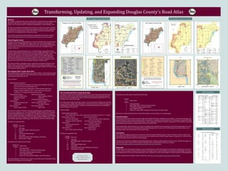
2007 Douglas County Road Atlas 2016 Douglas County Road Atlas
The Transformed 2016 County Road Atlas
The Atlas was maintained and updated over the years. In 2015, the need to transform and
expand the number of inset maps became apparent with the county’s population growth
and increase of road building. The Atlas was rebuilt and expanded using ArcGIS 10.2.1 for
Desktop & Esri’s Data Driven Pages.
Esri’s Data Driven Pages also quickly created a series of professional looking map books for
us to compile into a single atlas, splitting the county into numerous smaller map pages, and
handling all the details crucial for creating a true multi-page document just as MapLogic’s
Layout Manager previously did.
Layers included:
The Atlas was organized with:
Orthorectiϐied aerial photos
2015 USDA’s NAIP with 1-meter pixels and a horizontal accuracy of +/- 6 meters
Transportation features Special interest features
Private & Public Roads, Public buildings, Schools, Cemeteries
Highways, Airports, Railroad Local government boundaries
Land parcels Counties, Cities, Towns
Privately-owned parcels Public Land Survey System
Public lands Townships, Sections
Water features Recreational features
Rivers, Lakes, Streams, Springs Parks, Trails
Number
of Pages
Page Type
1 Title Page
2 Map Pages Index / Table Of Contents
1 Legend
69 Townships & Ranges maps
94 Inset maps
19 Indexes For Roads, Public Buildings, and Schools
186 Total number of pages
Six projects were also used to create the new 2016 atlas.
Each project could be printed from Esri’s Data Driven Pages as one document or as separate pages.
Transformation
The transformation of the county’s road atlas began with updated GIS layers, including new aerial photos, a new layer for springs, and
new grid indexes for the inset and township maps. A transparency was added to the aerial photos. The transparency along with smaller
halos around the annotation allowed the hatching for easier viewing of the public lands layer. Cemeteries are now included in the public
lands polygon layer, and not as a point feature as it was in the 2007 atlas.
The transformation continued when more maps were added to the township and inset grid layers. The ϐinal transformations were the
indexes. The schools index was combined with the public buildings index to create a new Public Buildings and Schools Index. A new
Recreation Index was created in place of the schools index.
Conclusion
Esri’s Data Driven Pages was easy to set up and use. It was more stable with fewer project crashes. The add-on created a cleaner and
more polished product with the tools to create a grid index, calculate adjacent ϐields for page numbers or page titles, as well as, tools to
easily insert page numbers and text on the layout page.
The new atlas is effortless to navigate using the Map Pages Index / Table of Contents pages to ϐind the way to a speciϐic atlas page or to
print the entire Atlas. In April 2016, the newly transformed Atlas was published on the county’s website:
http://www.douglascountywa.net/departments/gis/reference-maps/road-atlas
Biography
Amanda Taub is the GIS Analyst for Douglas County in the GIS Division of the Transportation & Land Services Department. For the last
15 years, she has created and maintained the majority of Douglas County’s maps in addition to her analysis responsibilities. The map is
never ϐinished, and it is her joy to keep improving it. If you would like to connect with Amanda on Twitter, look for her @amandahstaub.
For more information on Douglas County’s GIS Division, visit: http://www.douglascountywa.net/departments/gis.
Checkout the latest
edition of Douglas County
Road Atlas below!
Number
of
Projects
Project Type
1 Title page project
2 Maps Pages Index / Table of Contents projects
1 Townships & Ranges mapbook project
1 Insets mapbook project
1 Indexes for roads, public buildings & schools, and recreation project
2016 Road Index
2007 Road Index