1. Offsets
The lateral measurements taken to the left or right of a survey line to locate the
details such as buildings, boundaries, fences, etc, are called offsets.
• Short offsets (<15m)
Long offsets (>15m)
• Offsets are of two types: oblique, perpendicular.
• Optical square or a cross staff and chain or a tape is used for taking offsets.
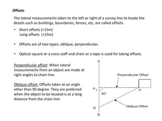
Perpendicular offset: When lateral
measurements from an object are made at
right angles to chain line.
Oblique offset: Offsets taken at an angle
other than 90 degree. They are preferred
when the object to be located is at a long
distance from the chain line.
4. The objects like pond, building, river, hill, valley, etc. which create difficulty in
continuing the chaining of a survey line is called obstacles. There are three types of
obstacle:
1) Obstacles to ranging but not for chaining
2) Obstacles to chaining but not for ranging
3) Obstacles to chaining and both ranging.
1) Obstacles to ranging but not for chaining: In this type of obstacle the
ends of a line are not intervisible.
a) Both ends are visible from the intermediate points, like rising ground: intermediate
ranging can be used to overcome the problem.
5. b) Both ends not visible from intermediate point, like wooded field
By using properties of similar triangles or Pythagoras theorem the
required length can be found
6. 2. Obstacles for chaining but not for ranging
The ends of line are inter-visible but chaining is obstructed by a pond or hedge,
etc.
Method 1
Method 2
Method 3
a) When chaining is possible around the object
10. • Graphical method- Field work and plotting done simultaneously
• Adopted in small mapping
• For filling details in map already prepared
• Consists of a drawing board provided with a ball and socket arrangement for
leveling the table, with arrangement to fix table to a tripod
11. Instruments used in plane table survey
Alidade Telescopic Alidade
Spirit level Trough compass
Plumbing fork
14. Advantages of Plane Table Surveying
• Suitable for location of details as well as contouring for large scale maps directly in the
field.
• Chances of omitting of any detail is less as surveying and plotting are done
simultaneously
• Errors and accuracy of the plot can be ascertained as the plotted details get compared
with actual objects present in the field
• Contours and specific features can be represented and checked conveniently as the
whole area is in view at the time of plotting
• Only relevant details are located because the map is drawn as the survey progresses.
Irrelevant details can be omitted on the field itself.
• Rapid and less costly than other types of survey
• As the instruments used are simple, not much skill for operation of instruments is
required. This method of survey requires no field book.
15. Disadvantage of Plane Table Surveying
• The plane table survey is not possible in unfavourable climate such as rain, fog,
etc.
• This method of survey is not very accurate and thus unsuitable for large scale or
precise work
• As no field book is maintained, plotting at different scale require full exercise.
• The method requires large amount of time to be spent in the field.
• Quality of the final map depends largely on the drafting capability of the
surveyor.
• This method is effective in relatively open country where stations can be sighted
easily.