Wetland Ecosystems
•Download as PPTX, PDF•
0 likes•353 views

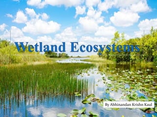
Wetlands are areas where water covers the soil, or is present either at or near the surface of the soil all year or for varying periods of time during the year, including during the growing season. View the presentation to know more!

Recommended
More Related Content
What's hot
What's hot (20)
Similar to Wetland Ecosystems
Similar to Wetland Ecosystems (20)
Recently uploaded
Recently uploaded (20)
Wetland Ecosystems
- 1. By Abhinandan Krishn Kaul
- 2. What Are Wetlands? Wetlands are areas where water covers the soil, or is present either at or near the surface of the soil all year or for varying periods of time during the year, including during the growing season. The wetlands ecosystem represents a richly diverse web of plants and animals interacting together.
- 3. As Defined By Ramsar Convention- “Areas of marshes, fen, peat land or water, whether natural or artificial, permanent or temporary, with water that is static or flowing, fresh, brackish or salt, including areas of marine water the depth of which at low tide does not exceed six meters”
- 4. Characteristics- Water table sits at or close to the surface of the land. Shallow water often covers the area. Land supporting aquatic vegetation. Substrate of saturated soil and substrates not comprised of soil but inundated with water during the growing season. Water can be freshwater, saltwater, brackish water or flowing water. Contain wet soils and typically anaerobic environments, and rooted plants and other forms of life used to those conditions.
- 6. A-biotic Factors Of Wetlands- Water Weather Tides Topography Sedimentation Erosion Turbidity Temperature Bedrock Climate Human Intrusion
- 7. Biotic Factors Of Wetlands- Herbivores Producers Omnivores Carnivores Decomposers Detritivores
- 8. Dominant Wildlife in Wetlands- Wetlands provide extraordinary wildlife diversity. Fishes Migratory Birds Mammals Amphibians
- 9. Services Provided By Or Derived From Wetland Ecosystems-
- 10. Some Threats facing wetlands-
- 11. Case Study- Ashtamudi Lake
- 12. Description Ashtamudi Lake in the Kollam District of the Indian state of Kerala, is the most visited backwater and lake in the state. It possesses a unique wetland ecosystem and a large palm-shaped (also described as octopus-shaped) water body, second only in size to the Vembanad estuary ecosystem of the state. Ashtamudi means 'eight braids' in the local Malayalam language. The name is indicative of the lake's topography with its multiple branches. The lake is also called the gateway to the backwaters of Kerala and is well known for its houseboat and backwater resorts.
- 13. History- The Ashtamudi lake's importance is claimed to be dated to the days of the Phoenicians and the Romans. Ibn Batuta, during his 24-year sojourn in the 14th century, is reported to have mentioned about the Quilon port as one of the five ports for Chinese trade. Links with Persia (9th century), Chinese mandarin in 1275 AD, Portuguese in 1502 AD, and the Dutch followed British in 1795 AD are recorded history. Velu Thampi is credited with organizing the rebellion against the British from this place. Ibn Batuta Velu Thampi
- 14. Topography Quaternary and Tertiary sediments and sedimentary rocks are the formations in the lake basin and environs. The Quaternary sediments are of marine and fluvial alluvium of recent age. Tertiary sediments comprise laterite, sandstones and clays of Warkalai formation. Geology Kallada River is a major river discharging into the Ashtamudi Lake. The Kallada river, which originates near Ponmudi from the Kulathupuzha hills Western Ghats is formed by the confluence of three rivers- Kulathupuzha, Chenthurnipuzha, and Kalthuruthipuzha, and after traversing a distance of about 121 km (75 mi) through virgin forests finally debouches into the Ashtamudi wetland at Peringalam near Kollam. With a maximum depth of 21 ft (6.4 m) at the confluence, it is Kerala's deepest estuary.
- 15. The average annual runoff from the river system into the estuary is reported to be 76 cubic kilometers of freshwater. The basin drainage area is 1,700 km2 (660 mi2) and with an average annual rainfall of 2400 mm (94 in) it discharges 3.375 km3 (2,740,000 ac·ft) of flow annually. It acts as a flood storage lake thus protecting the thickly populated city of Quilon (Kollam) and the coastal land. The Kallada dam built across the Kallada river is 85.3 m high by 35 m long (280 ft by 115 ft) with a reservoir area of 23 km2 (8.9 mi2) with a storage volume of 0.505 km3 (409,000 ac·ft). Though it provides irrigation to 61630 ha for paddy and upland crops, it has aggravated the salinity ingress into the wetland and the river due to reduced outflows during summer months. Ashtamudi Estuary has mangroves Avicennia officinalis, Brugiera gymnorrhiza and Sonneratia caseolaris as also 43 species of marshy and mangrove associates including two endangered species Syzygium travancoricum (endangered species according to the Red Data Book of Indian Plants) and Calamus rotang in the Terrestrial system. These species offer excellent scope for development of marine bioreserve to promote eco-tourism in the estuarine of the lake. Hydrology Flora
- 16. The lake supports 57 species of avifauna, of which 6 are migratory and 51 resident species. It is also reported that about 40 species of wetland-dependent birds are recorded in the lake, out of which 45% are long-distance migrants. Terns, plovers, cormorants, and herons are most abundant birds in the lake. A study report has identified 45 insect species, including 26 species of butterfly, 5 odonates, 9 hymenopteras, and 2 orthopterans, 1 hemipteran and 2 coleopterans. About 29 zooplankton species have also been identified. The water body is found to have 9 phytoplanktons such as Amphora, Borosigma, Cyclotella, Cymbella, Gyrozigma, Meloziva, Navicula and Nitzsch. 97 species of fish (42 are typically marine, 3 estuarine, 9 estuarine- riverine, 15 marine- estuarine) and unique copepod species. It is also a congenial habitat for all species of penaeid and palaemonid Prawns, edible crabs, paphia malabarica (short neck Clams) and a variety of fish. The estuary is the source of livelihood for thousands of fishermen and is stated to be the second biggest fish-landing centre after the Vembanad estuary Avifauna Aqua fauna
- 17. Economic evaluation An evaluation of the marketed use benefits of Ashtamudi estuary (valued using market valuation approach) has assessed the total direct use value at Rs.66.8 million per annum; coconut husk retting accounts for Rs.5.1 million, Inland navigation service accounts for Rs.3.7 million and the recreation benefit is assessed at Rs.1.5 million (using the standard travel cost method). But this is reported to be showing a downward trend, particularly in fish resources in the estuary.
- 18. Deterioration of the lake environment The following are reported to be the reasons for deterioration of the lake environment: Intense anthropogenic pressure. Oil spills from thousands of fishing boats and from industries in the surrounding area. Dwindling of the fragile lake zone due to conversion/destruction of natural habitats. Large quantities of untreated sewage, disposal of human excreta, and the pollution from paper mills, industries, etc. Many fish species may have become extinct due to lack of spawning facilities on the banks of the lake due to canalization of the lake's banks by walls built of laterite and granite stones.
- 19. Restoration plans Identify and phase out of the pollution sources. Better sanitation, reduction of industrial growth and reduction of urban waste. Address the declining fish stock production through concerted efforts to conserve the fish stock. Product diversification of coir to ensure better economic returns to people with the coordination of self-help groups Improved shore protection through mangrove a forestation. Mining to be allowed selectively at village level, away from the banks of the lake Discontinue estuary reclamation