Multispectral Imagery Data for Agricultural Surveying
poster_Aaron Capelouto
1. I would like to thank Dr. Goodall and his graduate student Benjamin Felton along with Dr. Wekker and Nathan Rose for their support. This project would not have been possible without their contributions.
Background
Unmanned Aerial Vehicles (UAVs) are gaining momentum when
it comes to solving complex research problems in fields ranging
from biology to agriculture to civil engineering. It is important to
be aware of the many regulations associated with flying UAVs
and the designation of your aircraft (civil, governmental, or
hobbyist). This project is focused on configuring a drone with a
multispectral camera attached and taking aerial photos of
wetlands/vegetated areas. The photos will then be processed
and the health of the vegetation can be assessed using the NDVI
value.
What exactly is NDVI?
Normalized Difference Vegetation Index is an equation that
provides insight into vegetation health of a given area. Healthy
vegetation does an excellent job at reflecting light in the Near-
infrared part of the spectrum. High NDVI values (near 1)
correspond to rainforests while low values (near 0) correspond
to barren areas.1
Objectives
The goal of this project is to assess the feasibility of using UAV’s
in multispectral image capture used for environmental decision
making with special emphasis on transportation applications. The
hope is that this project will help DOTs decide if this is a
technology worth pursuing.
Methods
Results
All things considered, UAVs serve as a legitimate option when
it comes to identifying wetlands. Figuring out how to process
the multi-spectral photographs and identifying a professor
with a COA served as a couple of the obstacles that we faced
throughout this project. Based upon the team’s experience
with the UAV, this technology is certainly worth pursuing.
Future recommendations and items to consider include:
• Give about 4-6 months as buffer time to obtain a COA and
proper regulatory paperwork. During this time, become
familiar with the drone and its functions. When applying
for the COA try and select a location with naturally
occurring wetlands.
• Outline specific goals for the flight. Once the objectives
have been laid out ahead of time, deciding on certain
equipment as well as a proper location (wetlands) will
become much easier.
• Continue to maintain a strong relationship and collaborate
with researchers in other departments and learn about the
advancements they are making in this field.
Additionally purchasing a drone with a longer battery life and
increased wind resistance will allow for an enhanced scope of
the mission along with the use of a pre-programmed flight
path from Mission Planner.
Conclusions/Future Work
1Ramos, Jennifer. "Normalized Difference Vegetation Index." The
Notable Trees of Villanova University. N.p., n.d. Web. 26 June
2015.
<http://www47.homepage.villanova.edu/guillaume.turcotte/stud
entprojects/arboretum/NDVI.htm>.
2 "Measuring Vegetation (NDVI & EVI)." Earth Observatory. NASA,
n.d. Web. 8 July
2015.<http://earthobservatory.nasa.gov/Features/MeasuringVeg
etation/measuring_vegetation_2.php>.
References
Feasibility of Using Drones in Environmental Decision Making
Aaron Capelouto
Georgia Institute of Technology
2Figure 2. NDVI of varying plant health.
Figure 1. NDVI Formula.
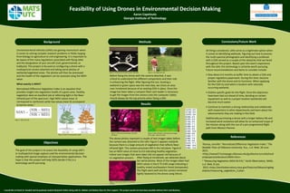
Figure 3. Cheerson CX-20 with camera attached. Figure 4. Test flight with X8+.
Before flying the drone with the camera attached, it was
critical to understand the different components and their role
in enhancing the flight. After figuring this out, locating a
wetland or green space was the next step, we chose an area
near Innisbrook because of an existing COA in place. Once the
image has been taken a compact flash card reader is necessary
to get the images from the camera onto the computer. Safety
should always be the top priority when flying a UAV.
Figure 5. Color-processed image of outside
courtyard.
Figure 6. NDVI of Figure 5 with pixel percentages
to the right. Taken 7/1/2015.
The above photos represent a couple of test images taken before
the camera was attached to the UAV. Figure 5 appears red/pink
because there is a large amount of vegetation that reflects Near-
infrared light. The camera processes NIR in the red plane. Figure 6
has an NDVI value of close to 0.6 indicating healthy vegetation.
Indoor test images that were taken did not appear red because of
no vegetation present.
-0.210, 0.0
-0.140, 0.0
-0.070, 3.6
0.000, 0.3
0.070, 0.4
0.150, 0.5
0.220, 1.1
0.290, 4.2
0.370, 9.5
0.440, 10.4
0.520, 8.5
0.590, 7.1
0.660, 7.9
0.740, 9.8
0.810, 11.1
0.880, 10.8
0.960, 13.9
After flying at Innisbrook, we obtained about
ten aerial photos. Most of the images taken had
NDVI values in the 0.75-0.85 range indicating a
healthy mixed southeastern forest (temperate).
The flight went well and the camera remained
tightly fastened to the drone using Velcro.
Figure 7. Aerial photo taken at Innisbrook,
7/10/15.