In the Picture: developing visual literacy through geography and history

Loading...

Flash Player 9 (or above) is needed to view presentations.
We have detected that you do not have it on your computer. To install it, go here.

0 comments

Post a comment

    Post a comment
    Embed Video
    Edit your comment Cancel

    4 Favorites

    In the Picture: developing visual literacy through geography and history - Presentation Transcript

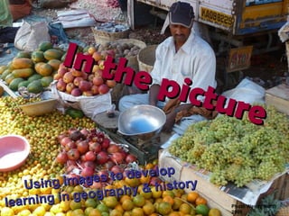
    1. In the picture Using images to develop learning in geography & history Photo Wendy North 2009
    2. What? Why? How? Where? When? Who? 5 W’s and How
      • We tend to assume that pictures are easy to understand, requiring little skill, and we often take it for granted that children see what they are asked to look at and that they see what we see in pictures.
      • Margaret Mackintosh
    3. Where? Where was the market image taken?
    4.  
    5.  
    6.  
    7. Course Outcomes
      • 1. Adapt the ideas shared during the day to make them work for your school, your children and the kind of curriculum that you want to teach. This means you will be using ICT frames to create your own personalised resource.
      Aim: to create ICT resources that are adapted to the needs of your children and your school 2. Share the resource you have developed with one or more teachers during the final session
    8. Put Yourself in the Picture What do you see, hear, smell and feel?
    9. Photo Wendy North 2009
    10. First of all we did some focused activities in the classroom that helped us develop using four of our five senses. In this way we learnt that we could describe a place with lots of details and it helped us to bring the place to life through words. Chembakolli – a village in India
    11. We followed this by using `freeze framing’ to help us take on the role of a character in the photograph. See our photographs on the right. CAN YOU WORK OUT WHICH FREEZE FRAME SHOWS … ? friends village school writing sieving concrete  the way home
    12. I can feel the soft blue powder the rough and hard wood. my bracelet tickling my arm. I can smell the misty air that blocked my nose. the moss on the trees and the dead leaves. Leah Sieving concrete I can see some trees gently brushing against each other, my friends working hard. the muddy floor I can hear the slight breeze shaking and rattling the trees my friends talking to me, telling me some things they are going to have for their tea. Photograph from Action Aid http:// www.chembakolli.com / Words: Y4 Waterton J & I
    13. Viking Traders Painting by Mark Bergin, … The daily Life of the Vikings, p. 17 ISBN 0 7502 3580 2 What would you ? What would you ?
    14. Putting Yourself in the Picture What do you see, hear, smell and feel? I can see …
    15. Conversation between Characters This photograph was taken during World War 2. What might these men be saying to one another?
    16. Visual Literacy
      • Visual literacy can be compared alongside text based`literacy’ in that they both employ similar processes:
          • identifying
          • decoding
          • interpreting
    17. Visual Literacy
      • How often do we focus on developing pupils’ skills of reading and interpreting images as opposed to developing these skills with text based sources.
      • Margaret Mackintosh
    18. Understanding both print and visual sources depends on:
      • Observation (based on the use of all the senses)
      • Prediction
      • Deduction /supposition
      • Narrative skills
    19. Looking, thinking & finding out
      • Observation
        • Senses sheet
      • Deduction/ Supposition
        • Conversation between characters
        • Evaluating evidence – What do I know for certain? (definite, possibly, probably true)
      http://www.geography.org.uk/eyprimary/visualgeography/researchframes
    20. Adapt Adopt Innovate
    21. Your turn ACTIVITY 2
    22. Using Images Geography History
    23. What items would we include in the category of image?
      • A picture
      • A photograph
      • A graphic
      • A diagram
      • A map
      • … or a collection of them
      • Chris Durbin, former geography inspector/adviser Staffordshire LA
    24. What is meant by an image
      • The perception of places that are inside our heads that derive from our experiences, both direct and indirect.
      • The messages given by a single source or by a collection of sources.
      • These may be photographs, diagrams or maps but they can also be written accounts.
      • Chris Durbin, former geography inspector/adviser Staffordshire LA
    25. Why do we use images?
      • To help to develop a `sense of place’
      • To foster enquiry skills
      • To improve visual literacy
      • To improve critical literacy
      • We use them together to help children to become better learners (of geography and history).
      • I want to
      • help children understand that there are many ways to live in the world and to be happy and fulfilled.
      • BUT also to understand that the unequal distribution of wealth and resources means that some people live very hard and difficult lives.
      Geography
    26. Photo Wendy North 2009
      • The Nuffield History Project view
      • We all come out of the past, and what happened there influences what happens here and now – we need to know so we can understand the world today.
      • Through history, we can lead children to understand how human beings behave and why people act as they do.
      • By getting inside the past, we can lead children to respect and value each different period and society in its own terms.
      • http:// www.nuffieldfoundation.org/primaryhistory /
      History
    27. What can you work out from the photograph? What do you know for certain? What questions would you like to ask?
      • The skill of looking at, understanding and interpreting pictures has to be taught through planned directed study .
      • Margaret Mackintosh
      • Chapter 9, Primary Geography Handbook (2004) ISBN 1-84377-103-9
    28. Elizabeth – mistress of spin What do I want you to know about me?
    29. Web-links
      • Geography online course materials at:
      • http://www.geographyteachingtoday.org.uk/ks1-3-courses/course/primary-geography-and-ict/
      • Geographical Association – Visual Geography
      • http:// www.geography.org.uk/eyprimary/visualgeography /
      • Wakefield VLE
      • http:// www.wakefieldinset.wakefield.yhgfl.net/mydesktop /
        • User name
        • Password

    + GeoprimaryGeoprimary, 8 months ago

    custom

    1263 views, 4 favs, 1 embeds more stats

    The introductory presentation, used for Session 1 o more

    More info about this document

    © All Rights Reserved

    Go to text version

    • Total Views 1263
      • 1237 on SlideShare
      • 26 from embeds
    • Comments 0
    • Favorites 4
    • Downloads 31
    Most viewed embeds
    • 26 views on http://primarygeogblog.blogspot.com

    more

    All embeds
    • 26 views on http://primarygeogblog.blogspot.com

    less

    Flagged as inappropriate Flag as inappropriate
    Flag as inappropriate

    Select your reason for flagging this presentation as inappropriate. If needed, use the feedback form to let us know more details.

    Cancel
    File a copyright complaint
    Having problems? Go to our helpdesk?

    Categories