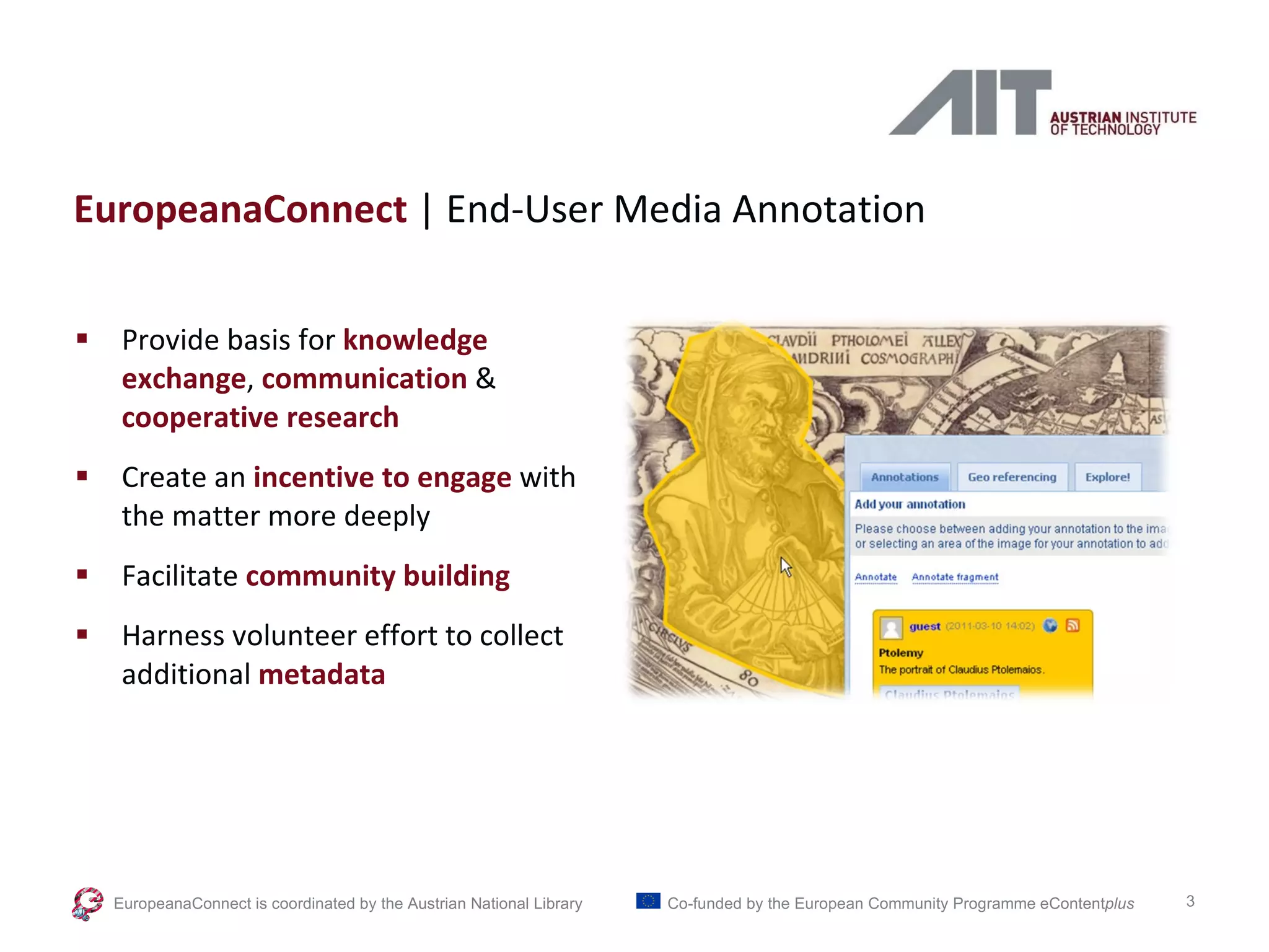
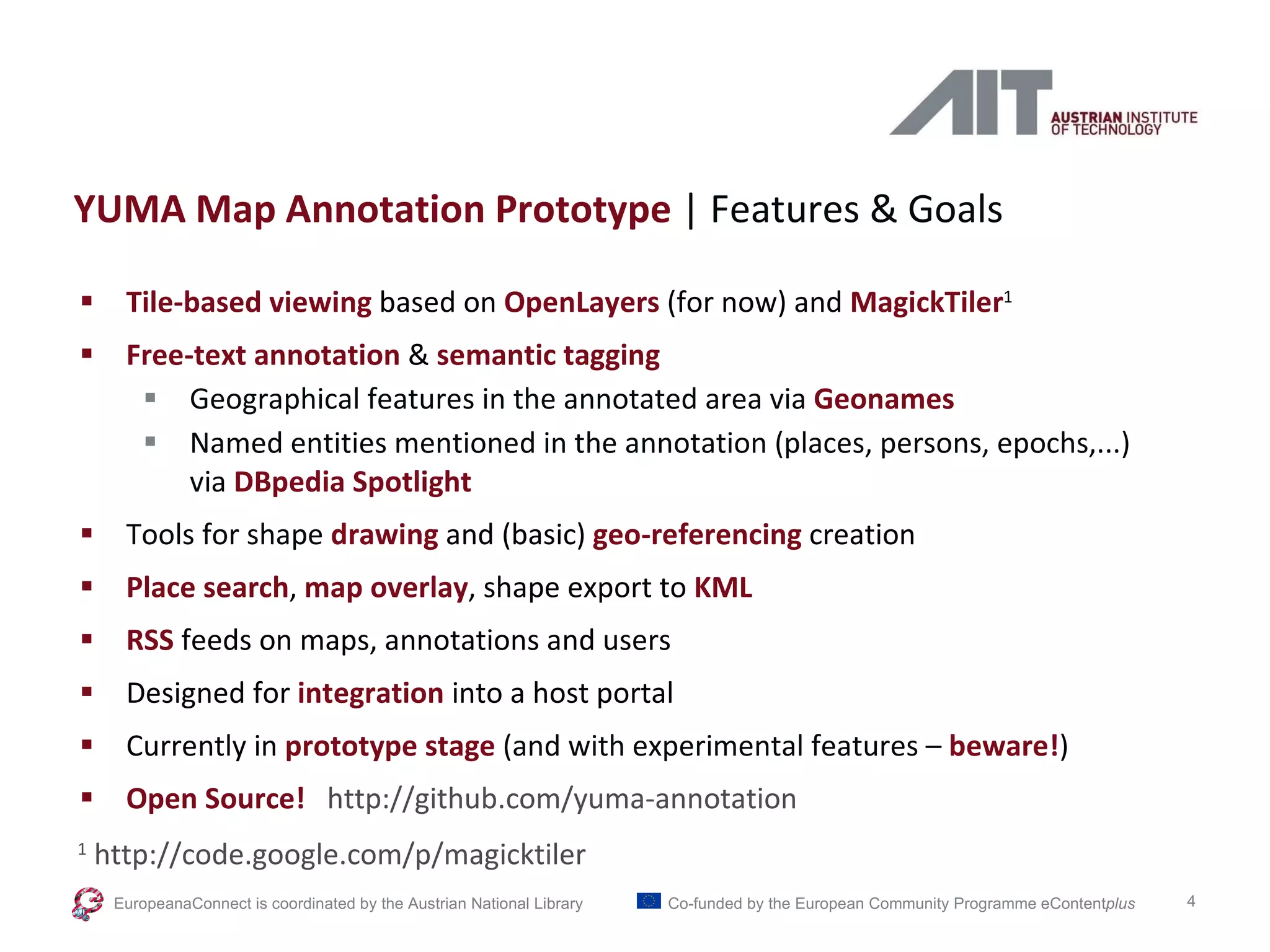
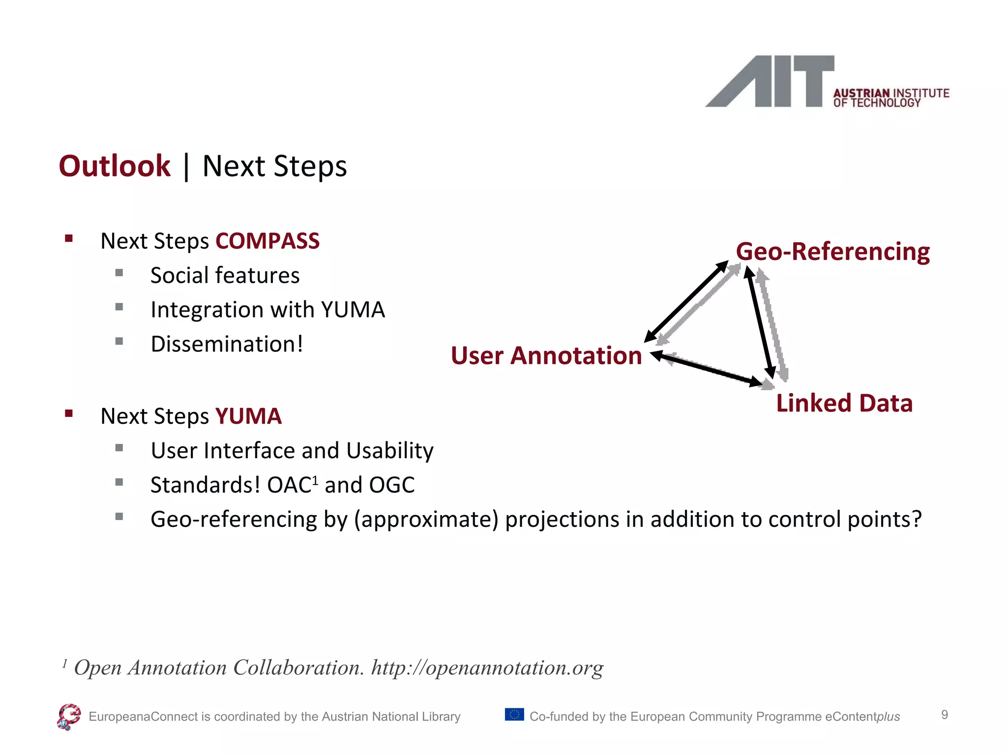
Annotations, Tags & Linked Data Metadata Enrichment in Online Map Collections through Volunteer-Contributed Information Rainer Simon , Joachim Jung Austrian Institute of Technology Bernhard Haslhofer Cornell University 6 th  International Workshop on Digital  Approaches in Cartographic Heritage April 7, 2011  | The Hague, Netherlands
Part of Europeana Connect  EU Project Core Components for the European Digital Library www.europeanaconnect.eu EuropeanaConnect is coordinated by the  Austrian National Library Co-funded by the European Community Programme  eContent plus
EuropeanaConnect  | End-User Media Annotation Provide basis for  knowledge exchange ,  communication   & cooperative research Create an  incentive to engage  with the matter more deeply Facilitate  community building Harness volunteer effort to collect additional   metadata EuropeanaConnect is coordinated by the  Austrian National Library Co-funded by the European Community Programme  eContent plus
YUMA Map Annotation Prototype  | Features & Goals Tile-based viewing  based on  OpenLayers  (for now) and  MagickTiler 1 Free-text annotation  &  semantic tagging Geographical features in the annotated area via  Geonames Named entities mentioned in the annotation (places, persons, epochs,...) via  DBpedia Spotlight Tools for shape  drawing  and (basic)  geo-referencing  creation Place search ,  map overlay , shape export to  KML RSS  feeds on maps, annotations and users Designed for  integration  into a host portal Currently in  prototype stage   (and with experimental features –  beware! ) Open Source!   http://github.com/yuma-annotation  1  http://code.google.com/p/magicktiler EuropeanaConnect is coordinated by the  Austrian National Library Co-funded by the European Community Programme  eContent plus
Without Further Ado  | The Screencast(s) EuropeanaConnect is coordinated by the  Austrian National Library Co-funded by the European Community Programme  eContent plus
Linked Data  | Some Basics and Some Benefits Basics 1 URIs for as names for things HTTP URIs so we can get information about those things http://dbpedia.org/resource/Gibraltar http://sws.geonames.org/2411585/ http://dme.ait.ac.at/yuma-server/api/annotation/39 (Typed) Links to other URIs so we can discover more things Many relevant datasets out there already! Benefits (for map search) Multilingual & synonym search Spatial metadata & geographical search – control points as by-products of annotation? 1  Berners-Lee, Tim (2006)  Linked Data – Design Issues. http://www.w3.org/DesignIssues/LinkedData.html EuropeanaConnect is coordinated by the  Austrian National Library Co-funded by the European Community Programme  eContent plus
Towards Evaluating YUMA  | The COMPASS Experiment Building  Ground Truth 6.306 maps from the Library of Congress (batch converted to Zoomify) Original map metadata 130.935 (anonymous) user search queries Custom Web application for collecting relevance judgements  First stage: corpus of 400 sample queries Preliminary  Results Users invited from MapHist and IFLA DIGLIB, INETBIB mailing lists 75 participants, 12+ countries, 1.800+ judgements (approx. 45% of target) EuropeanaConnect is coordinated by the  Austrian National Library Co-funded by the European Community Programme  eContent plus
Towards Evaluating YUMA  | The COMPASS Experiment EuropeanaConnect is coordinated by the  Austrian National Library Co-funded by the European Community Programme  eContent plus
Outlook  | Next Steps Next Steps  COMPASS Social features Integration with YUMA Dissemination! Next Steps  YUMA User Interface and Usability Standards! OAC 1  and OGC Geo-referencing by (approximate) projections in addition to control points? 1  Open Annotation Collaboration. http://openannotation.org EuropeanaConnect is coordinated by the  Austrian National Library Co-funded by the European Community Programme  eContent plus Geo-Referencing User Annotation Linked Data
Thank you for your attention Questions! References Martin Waldseemüller (1470–1521), Universalis Cosmographia Secundum Ptholomaei Traditionem et Americi Vespucii Alioru[m]que Lustrationes, St. Dié, 1507, Geography and Map Division, Library of Congress. J. Hessler, “Warping Waldseemüller: A Phenomenological and Computational Study of the 1507 World Map”, Cartographica 41 (2006): 101-113. http://warpinghistory.blogspot.com/2006/10/what-can-waldseemllers-projection-tell.html http://dme.ait.ac.at/annotation  (take the tour) http://github.com/yuma-annotation  (get the code) http://compass.cs.univie.ac.at  (help us evaluate!) EuropeanaConnect is coordinated by the  Austrian National Library Co-funded by the European Community Programme  eContent plus

CartoHeritage 2011: Annotations, Tags and Linked Data

  • 1.
    Annotations, Tags &Linked Data Metadata Enrichment in Online Map Collections through Volunteer-Contributed Information Rainer Simon , Joachim Jung Austrian Institute of Technology Bernhard Haslhofer Cornell University 6 th International Workshop on Digital Approaches in Cartographic Heritage April 7, 2011 | The Hague, Netherlands
  • 2.
    Part of EuropeanaConnect EU Project Core Components for the European Digital Library www.europeanaconnect.eu EuropeanaConnect is coordinated by the Austrian National Library Co-funded by the European Community Programme eContent plus
  • 3.
    EuropeanaConnect |End-User Media Annotation Provide basis for knowledge exchange , communication & cooperative research Create an incentive to engage with the matter more deeply Facilitate community building Harness volunteer effort to collect additional metadata EuropeanaConnect is coordinated by the Austrian National Library Co-funded by the European Community Programme eContent plus
  • 4.
    YUMA Map AnnotationPrototype | Features & Goals Tile-based viewing based on OpenLayers (for now) and MagickTiler 1 Free-text annotation & semantic tagging Geographical features in the annotated area via Geonames Named entities mentioned in the annotation (places, persons, epochs,...) via DBpedia Spotlight Tools for shape drawing and (basic) geo-referencing creation Place search , map overlay , shape export to KML RSS feeds on maps, annotations and users Designed for integration into a host portal Currently in prototype stage (and with experimental features – beware! ) Open Source! http://github.com/yuma-annotation 1 http://code.google.com/p/magicktiler EuropeanaConnect is coordinated by the Austrian National Library Co-funded by the European Community Programme eContent plus
  • 5.
    Without Further Ado | The Screencast(s) EuropeanaConnect is coordinated by the Austrian National Library Co-funded by the European Community Programme eContent plus
  • 6.
    Linked Data | Some Basics and Some Benefits Basics 1 URIs for as names for things HTTP URIs so we can get information about those things http://dbpedia.org/resource/Gibraltar http://sws.geonames.org/2411585/ http://dme.ait.ac.at/yuma-server/api/annotation/39 (Typed) Links to other URIs so we can discover more things Many relevant datasets out there already! Benefits (for map search) Multilingual & synonym search Spatial metadata & geographical search – control points as by-products of annotation? 1 Berners-Lee, Tim (2006) Linked Data – Design Issues. http://www.w3.org/DesignIssues/LinkedData.html EuropeanaConnect is coordinated by the Austrian National Library Co-funded by the European Community Programme eContent plus
  • 7.
    Towards Evaluating YUMA | The COMPASS Experiment Building Ground Truth 6.306 maps from the Library of Congress (batch converted to Zoomify) Original map metadata 130.935 (anonymous) user search queries Custom Web application for collecting relevance judgements First stage: corpus of 400 sample queries Preliminary Results Users invited from MapHist and IFLA DIGLIB, INETBIB mailing lists 75 participants, 12+ countries, 1.800+ judgements (approx. 45% of target) EuropeanaConnect is coordinated by the Austrian National Library Co-funded by the European Community Programme eContent plus
  • 8.
    Towards Evaluating YUMA | The COMPASS Experiment EuropeanaConnect is coordinated by the Austrian National Library Co-funded by the European Community Programme eContent plus
  • 9.
    Outlook |Next Steps Next Steps COMPASS Social features Integration with YUMA Dissemination! Next Steps YUMA User Interface and Usability Standards! OAC 1 and OGC Geo-referencing by (approximate) projections in addition to control points? 1 Open Annotation Collaboration. http://openannotation.org EuropeanaConnect is coordinated by the Austrian National Library Co-funded by the European Community Programme eContent plus Geo-Referencing User Annotation Linked Data
  • 10.
    Thank you foryour attention Questions! References Martin Waldseemüller (1470–1521), Universalis Cosmographia Secundum Ptholomaei Traditionem et Americi Vespucii Alioru[m]que Lustrationes, St. Dié, 1507, Geography and Map Division, Library of Congress. J. Hessler, “Warping Waldseemüller: A Phenomenological and Computational Study of the 1507 World Map”, Cartographica 41 (2006): 101-113. http://warpinghistory.blogspot.com/2006/10/what-can-waldseemllers-projection-tell.html http://dme.ait.ac.at/annotation (take the tour) http://github.com/yuma-annotation (get the code) http://compass.cs.univie.ac.at (help us evaluate!) EuropeanaConnect is coordinated by the Austrian National Library Co-funded by the European Community Programme eContent plus

Editor's Notes