SlideShare a Scribd company logo
1 of 62
Download to read offline
THE CENTER FOR
ADVANCED URBAN
VISIONING
THE PARADISE PROJECT
IMPLEMENTING “TEMPORARY PARADISE?”
DISCUSSION PAPER SERIES
Moving About
Paradise
Comparing the Quickway Proposal
with the SANDAG RTP 2050 Transit Plan
for Area Coverage and Transit Travel Times
The Quickway
Proposal
SANDAG RTP 2050
Transit Plan
Alan S. Hoffman
Lecturer in City Planning
San Diego State University
“Leadership Starts Here”
JULY 2017
Moving About Paradise
Comparing the Quickway Proposal
with the SANDAG RTP 2050 Transit Plan
for Area Coverage and Transit Travel Times
© 2017 by The Center for Advanced Urban Visioning
(619) 232-1776 • urbanvisioning@outlook.com
Foreward
The maps in this paper highlight the differences in coverage and travel time between
the RTP 2050 Transit Plan and the Quickway Proposal’s alternative plan for transit
systems development.
The questions that should guide the viewer of these maps include the
following:
1. Which system would you be more likely to use?
2. Which network is more likely to be useful to residents of San
Diego?
3. Which network would better serve the region, by attracting and
serving more users, reducing traffic and parking impacts, and
better anchoring new development?
A Note on
Coverage Maps
The maps in this paper make a clear distinction between Rapid Transit and “Semi-
Rapid Transit.” Rapid Transit is defined as a transit service that maintains a through-
speed along most of its length of at least 18 mph during the AM commute. Much of
the Trolley system averages 25-27 mph, clearly achieving Rapid Transit status. Rapid
Bus routes are more problematic; those that operate on freeways meet the standard
for Rapid Transit, but arterial operations are typically far short of 18 mph; for example,
the Rapid Bus Route 215 on El Cajon Blvd averages about 12 mph from College Avenue
through to University Avenue during the AM peak, far below the 18 mph threshold.
While RTP-defined arterial Rapid Bus services are clearly Semi-Rapid Transit by our
definition, what about services that operate as Rapid Transit along a dedicated
guideway but then travel essentially as an arterial Rapid Bus, such as the Quickway
Proposal’s MetroXpress Network? For those boarding or alighting at these
stations/stops, they will experience their trip as closer to Rapid Transit than Semi-
Rapid; as a result, the first three stations/stops on an arterial are depicted as halfway
between Rapid Transit and Semi-Rapid, both for the RTP (such as in Kearny Mesa) or
the Quickway Proposal (most MetroXpress routes).
Contents
1. The Case for a New Transit Plan
2. The Quickway Proposal in Brief
3. Quickway 2025: The Mid-Coast Supportive Projects
4. Station Area Coverage
• Uptown / North Park / City Heights
• San Diego District 7 / Kearny Mesa / Linda Vista / Clairemont
• PB / MB / Mission Bay
• Point Loma / Peninsula
• Downtown / Surrounding Communities
• National City / Southeast
• Chula Vista
• Central Coastal North County / Carlsbad
5. Transit Travel Time Comparisons
• AM Commute – Accessing Fashion Valley Transit Center
• Quickway Proposal vs. Transit Today
FOR MORE INFORMATION ON THE QUICKWAY PROPOSAL:
View the introductory presentation:
www.slideshare.net/UrbanVisioning/quickwayproposalintro
Read the discussion paper “Preserving Paradise”:
www.slideshare.net/UrbanVisioning/preserving-paradise-77620902
View maps and other project documents:
www.quickwayproposal.wix.com/proposal
THE PARADISE PROJECT
IMPLEMENTING “TEMPORARY PARADISE?”
DISCUSSION PAPER SERIES
1
Preserving Paradise:
How a Better Connected San Diego Can Serve Residents,
Reduce Traffic, and Save Taxpayers Money
2
Moving About Paradise:
Comparing the Quickway Proposal
with the SANDAG RTP 2050 Transit Plan
for Area Coverage and Transit Travel Times
1
The Case for a
New Transit Plan
The case for a new transit plan can be summed up in 10 points.
1. Virtually all of the region’s growth plans revolve around transit.
SANDAG’s growth plan is one example, calling for the vast majority of new housing to be located within ½
mile of a “high frequency” transit route.1
Transit is expected to absorb a significant share of trips from
new development. For transit to attract these new riders, it must be perceived as convenient, affordable,
safe, fast, and attractive. The better a job transit does at meeting these standards, the more effective it
will be at attracting new riders, attracting more station-area development, and moving enough people to
significantly relieve pressure off the automotive/road side.
2. For San Diego to meet ambitious Climate Action Plan and Smart Growth targets, many trips
will need to shift toward transit and other modes.
Regional long-range goals require that many automobile trips be shifted onto transit. This is why our
regional growth strategies call for locating new development near transit. If a transit system could
significantly increase its contribution toward these targets for a comparable—perhaps even cheaper—
cost, it would make sense to pursue the possibility.
3. Transit investments in San Diego have so far failed to attract the people that must be
attracted to transit: middle-income people who commute by car.
There is considerable evidence to back up this claim.
a. The Trolley doesn’t attract a broader demographic than the city bus. For both Trolley and
MTS Bus, over half of all riders hail from households with annual incomes below $35,000; about
80% are from households earning less than $50,000.2
b. The Trolley attracts relatively few people who otherwise would have driven. About 64% of
Trolley riders did not have access to a car for their trip, only marginally better than the 72% of
bus riders who lacked auto access.3
1
“High-frequency transit” includes city bus routes that operate at a 15 minute frequency, regardless of actual
expected travel times to desired locations.
2
These figures from SANDAG’s 2015 Onboard Passenger Survey, p. 16. The average income of the poorest riders has
increased relative to 2009, but the percent of riders from households earning under $50,000/year is unchanged.
3
This represents a slight improvement over 2009 data (65% Trolley and 75% Bus). Source: SANDAG 2015 Onboard
Passenger Survey, p. 10.
2
c. According to the US Census, the use of transit in San Diego has been trending downward.
Even more troubling, carpooling—the basis of SANDAG’s massive investments in HOV and
managed lanes—has decreased by a third, the largest decrease of any transportation mode.4
4. Our current regional transit plans are unlikely to meet modal shift goals.
SANDAG’s current plans, after spending more than $20 billion on new projects and over $100 billion total
on transit—would reduce the amount of time the average transit trip takes by only about 19%, cutting a
60 minute commute to 48.6 minutes—an improvement, certainly, but still generally uncompetitive with
the automobile. The more competitive time-wise transit is with driving, especially among and between
key destinations and areas with easy access to residences or higher residential densities, and the better a
job transit does of improving the customer experience (current station design exposes riders to rain, hot
sun, cold winds, and moving vehicles) the more likely it is to meet and exceed modal shift goals—or allow
more ambitious ones to become realistic options.
5. Transit must be better located, significantly faster, more frequent, offer a better experience,
and be easier/more convenient to use, if the goal is to attract many more riders.
These points are reinforced in the New York-based Transitcenter’s study, “Who’s On Board 2016,”
available at http://transitcenter.org/publications/whos-on-board-2016/–a “must-read” for anyone
interested in improving the effectiveness of transit. The key findings of this study5
were:
a. The most important “first mile/last mile” solution is walking.
The majority of transit riders, including 80 percent of all-purpose riders, typically walk to transit.
This finding underscores the importance of putting transit stations in busy, walkable
neighborhoods; building offices and housing within walking distance of transit; and providing
more and safer pedestrian routes to transit.
b. The two most important determinants of rider satisfaction with transit are service frequency
and travel time.
The availability of information and conditions at the station or stop were also important,
suggesting that real-time information and shelters are important amenities for transit agencies to
provide.
c. There are three common patterns of transit use:
 Occasional riders who take transit once in a while,
 Commuters who take transit regularly but only for work,
 and all-purpose riders who take transit regularly for multiple purposes.
Transit agencies should strive to grow this third category of rider, as they are the most reliable
and financially efficient customers to serve. All-purpose riders are more prevalent where it’s easy
to walk to transit, and where transit is frequent and provides access to many destinations.
4
Managed and HOV lanes are a core SANDAG transportation strategy; their disappointing impact on carpooling may
be taken as evidence that the strategy is mismatched to actual travel needs.
5
Source: http://transitcenter.org/publications/whos-on-board-2016/#how-people-use-transit. Emphasis added.
3
d. Transit riders are sensitive to transit quality, not “captive” to transit.
Who’s On Board finds that the “captivity” of carless riders is severely overstated. People who live
and work near better transit ride transit more often, whether or not they own cars. When transit
becomes functionally useless, there are very few people who will continue to use it; agencies can
take no one for granted.
6. Failure to achieve transit goals imperils our future prosperity and quality of life.
Communities often oppose new development because of traffic and parking impacts. This dynamic is one
factor behind our current housing shortfall; we need to be building 14-15,000 dwelling units a year to
meet market demand, but are building only around 6,000/year.6
This leaves families and individuals
stretched even thinner by rising rents, with employers looking at shifting jobs out of state, given their
inability to pay wages that would permit employees to afford housing in San Diego’s real estate market.
If communities experiencing significant growth pressures were provisioned with integrated infrastructure
that improved existing conditions, created new public space and amenity, and that successfully managed
parking and traffic impacts, then communities would be more receptive to new development. If a cost-
effective means of creating this infrastructure can be devised, then the benefits to the region would be at
a very large scale.
7. The solution to this problem is a more effective transit plan.
A smarter transit plan:
 Reaches into more urban centers,
 Slashes travel time,
 Reduces wait time and transfers,
 Is more convenient to use, and
 Features stations that provide better safety and comfort.
The Quickway Proposal is such an alternative. It advocates a fundamentally different strategy for transit
than that outlined in SANDAG’s Regional Transportation Plan (RTP); this strategy is detailed in Preserving
Paradise, the first Discussion Paper in the Paradise Project series, and is briefly outlined in the next
chapter of this paper. Extensive analysis of the proposal confirms the effectiveness of the Quickway
Proposal as an alternative strategy:
a. Ridership gains. Quickway Proposal transit ridership is projected to nearly double per invested
dollar compared to SANDAG’s plan.7
6
There are many other factors that contribute to the housing shortfall, but a smarter transit strategy, designed to
actually mitigate the impacts of new development, can make a notable difference in opening up more urban land
for new housing.
7
This figure is interpolated from the ridership and capital cost analysis reported on in The Quickway Proposal: A
Proposal for an Affordable and Effective Rapid Transit System for the Greater San Diego Region, available for
download at http://quickwayproposal.wixsite.com/proposal/reports. Independent analysis of a similar strategy
developed for the Metro Atlanta region also found a doubling in ridership per invested capital dollar compared to
their official transit plan (source: Metro Atlanta Chamber of Commerce, et. al., Atlanta’s Transit Future: Market
Research Results, February 2004).
4
b. Cost savings. Capital costs are projected to be several billion dollars less than our current plan
(our capital cost model accurately projected costs on several projects across North America).
c. Reduced subsidies. Projected reductions in operating subsidies of several billion by 2050.
d. Development. The Quickway Proposal places real infrastructure in the heart of our most
urbanized zones, mitigating the parking and traffic impacts of new and existing development.
In essence, the Quickway Proposal is designed to produce the results spoken of by TransitCenter (in Point
#5 above): better located, faster, more frequent, fewer transfers, more convenient, and with a superior
customer experience.
8. The Quickway Proposal is a more effective plan and can be built in stages, each of which
would provide an immediate benefit.
The first elements of the Quickway Proposal proposed for development—The Mid-Coast Supportive
Projects—are designed to increase ridership on new and existing Trolley lines, create an effective
movement system within the urbanized core, and support areas experiencing development pressure
where the right infrastructure can mitigate the effects of traffic and parking congestion. For about the
projected cost of the Mid-Coast Trolley, the Mid-Coast Supportive Projects add twice as many rapid
transit stations and about 90 arterial (“Rapid Bus”) stations built to a new, customer-friendly model.
These projects will contribute more to climate change goals than any transit project in the current RTP.
These projects are discussed in detail in Preserving Paradise; they are highlighted in Chapter Three of this
report.
9. The Quickway Proposal integrates well with parallel infrastructure (bicycle, walking, etc.) and
land use plans for several communities, creating synergies and solving real problems.
Among these plans are the Uptown 2025 Proposal, which looks at creating infrastructure to mitigate
ongoing development in the Uptown communities. This Proposal was endorsed by the Hillcrest Town
Council and the Bankers Hill Community Group. By integrating road, parking, world-class bicycling,
landscaping, and parklands/people space into a coherent whole, Uptown could become the poster
community for how to achieve Climate Change Goals. Other such proposals are forthcoming and will be
discussed in Discussion Paper #3 in the Paradise Project series.
10. The Quickway Proposal shows how the right transit infrastructure, backed by the right service
plan, can better achieve our goals and notably improve regional quality of life.
5
The Quickway
Proposal in Brief
The Quickway Proposal is a strategy for creating a world-class and regionally effective transit system for
San Diego. Unlike current plans—which rely on several new Trolley lines, and many new “Rapid Bus” lines
(some freeway-running, most arterial-running)—the Quickway Proposal is designed to:
 Better serve our denser, more urban neighborhoods,
 Cut transit travel time by nearly 2/3,
 Reduce operating subsidies,
 Better support locations experiencing development pressures, and
 Attract many more riders by offering a compelling and competitive alternative to driving from
many more origins to many more destinations.
1. What are Quickways?
Quickways are grade-separated transitways with the
following characteristics:
 Travel lanes. Between stations, they
commonly feature a single travel lane in each
direction;
 Grade-separation, so all cross traffic (both
auto and pedestrian) goes either over or
under Quickways, like with a freeway;
 Real “rapid transit” stations featuring
passing lanes (to support express operations),
typically spaced about a mile apart (closer in
some areas, farther in others);
 “SuperStations,” which are larger and at which passing express services stop (SuperStations are
typically spaced 3-5 miles apart); and
 Route structure. At least three kinds of transit lines/routes use Quickways: all-stop, trolley-like
routes; MetroXpress routes that skip most intervening stops; and emergency services vehicles
(the Quickway Proposal directly serves most major hospitals in the region).
2. Are Quickways “BRT” (Bus Rapid Transit)?
Quickways are not a “BRT” (Bus Rapid Transit) proposal nor is the proposal even remotely about an
unproductive rail vs. bus debate. Rather, the proposed strategy suggests a smarter way to evolve toward
a “permanent” rapid transit system. It begins by using buses (much like our new Rapid Buses), but is
designed to develop and grow into some other more advanced guided technology, such as rail, over time.
6
3. What are the core elements of the Quickway Proposal?
The Quickway Proposal is designed to create a more pervasive and effective rapid transit system for the
San Diego region. It targets our region’s most urban zones with rapid services and quality infrastructure
so as to create a transit system that is significantly faster, goes more places, is more comfortable and
convenient to use, and is ultimately cheaper to operate. It consists of the following elements:
 Quickways. A core network of about 100 miles of Quickways, the majority of which are surface-
running but still grade-separated to optimize transit flows and reduce operating costs.
 Surface “T-Ways” (at-grade transitways) and bus lanes feeding into and off of the Quickway
infrastructure.
 Light rail extensions where these extensions make sense.
 Streetcars. At least three new streetcar systems.
 Improved stations, including a modular arterial station that provides better protection from the
elements (sun, wind, and the occasional rain) as well as from moving vehicles.
 “Satellite” entrances to stations, using
automated vehicles operating like “horizontal
elevators,” extending the effective reach of
certain stations to get people much closer to
origins and destinations with minimal waiting
(per the illustration on the right, looking down
at city blocks and streets).
 Road improvements, often tied to transit
projects, to provide greater capacity in areas
experiencing strong growth pressure.
 A new regional express system, MetroXpress,
making it far faster for people to travel longer
distances.
The Quickway Proposal is also designed to integrate with related proposals to create significant new
parklands and public spaces, as well as bicycle and pedestrian infrastructure.
4. What are “MetroXpress” routes?
MetroXpress routes are the secret to the Quickway Proposal’s
time savings compared to the RTP transit plan. Most
MetroXpress routes begin as “Rapid Bus” routes along key
arterials, albeit with improved arterial station facilities that
provide better protection for passengers. Upon entering a
Quickway, these routes stop at the first station, then proceed
express to their destination, stopping only at “SuperStations,”
enabling transfers to other MetroXpress routes.
MetroXpress routes are based on the “Speedy” network of
Curitiba, Brazil, and the CityXpress network of Brisbane,
Australia. Such networks significantly reduce travel times and
operating costs, all while attracting many more riders.
7
5. What is the migration path for Quickways?
The Quickway strategy is threefold:
1. Target. Build Quickway infrastructure
where it produces the greatest bang
for the buck,
2. Connect. Build the connecting pieces
over time, and then
3. Transform. Upconvert to some form
of rail or other automated, guided
technology.
This illustration, from Preserving Paradise,
explains the central strategy behind
developing Quickways.
The key point is that the Quickway Proposal does not in the least preclude the creation of an effective
regional rail system; it rather suggests the strategy by which such a system may be evolved so that
benefits accrue immediately and the region can enjoy a transit system optimized for San Diego.
6. Why “satellite entrances” at some stations?
Anyone who has ever entered a subway station via an escalator or elevator has already used a “satellite
entrance”; the surface entryway is actually to a mode (escalator or elevator) that then connects to the
actual transit station.
Satellite entrances extend the reach of a rapid transit station, significantly increasing access and
attracting new riders. To work, they must feature extremely high frequencies and very short travel times
between the satellite entrance and the main station.
Satellite entrances in the Quickway Proposal are designed to support a 2-minute frequency or better
using paired shuttles (2-3 minutes if only one vehicle is employed, which would be expected at times of
low demand). These shuttles will most likely be autonomous (driverless) vehicles traveling along a
dedicated pathway (one example of a commercially-deployed autonomous shuttle is pictured in the
illustration explaining satellite operations). Shuttles offer the ability to offer point-to-point super-high
frequency service at minimal operating cost.
7. Where are the first segments to be built?
In the first stage, Quickway segments are built where they will produce the greatest benefit. Since it is
impossible to build a rail segment here and another there—rail lines must be connected or trains cannot
make the leap—it makes sense to use “Rapid Buses” to begin operations and then upgrade once
continuous infrastructure is built. For example, two tunnel segments might be built on University Avenue,
about a mile apart, under the centers of Hillcrest and North Park. Any Rapid Bus making this connection
8
would see travel time cut by a third with greater reliability and a vastly improved customer experience. To
build this as rail would require continuous rail tracks connecting the two, doubling or tripling the initial
investment required to create the connection (and precluding the operation of MetroXpress services,
which branch off to multiple destinations at a significant travel time savings).
Why does travel time savings matter so much? Because it is directly linked to ridership—the faster a
transit route, the more people it attracts—and to costs. Costs in transit are driven primarily by time; the
faster a given service, the cheaper it is to operate and the more trips you can get from a single vehicle.
Add to that the increase in fare revenue due to new passengers, and a 1/3 reduction in time may have an
oversized impact on that route (and others that connect with it). Taxpayers especially benefit from this
“virtuous circle”: their investments in transit produce a greater return on investment, subsidy levels go
down, and the larger strategic reasons for creating rapid transit are more successfully met.
8. What Quickway and related infrastructure is being proposed for different communities?
Draft infrastructure and service maps are provided in Preserving Paradise, the initial Discussion Paper in
the Paradise Project Series and are also available online (see above). In the coverage maps that follow in
this document, Quickway and related alignments (and MetroXpress arterial corridors) are depicted as
well.
9. How can I learn more about the Quickway Proposal?
 Introductory Presentation, available for view at www.facebook.com/QuickwayProposal.
 Discussion Paper, Preserving Paradise, compares & contrasts the Quickway Proposal with the
SANDAG RTP transit plan: www.slideshare.net/UrbanVisioning/preserving-paradise-77620902.
 Project Report & Maps at www.quickwayproposal.wix.com/proposal.
9
“Quickway 2025”:
The Mid-Coast Supportive Projects
A new Trolley line—the Mid-Coast Light Rail Project—is under construction in San Diego. This $2.17 billion
effort will extend the Trolley from Old Town north alongside I-5 to UCSD and the Golden Triangle, adding
nine new stations to the trolley network.
The Quickway Proposal takes advantage of our region’s investments in light rail by, in part, feeding people
to and from trolley stations from many more locations, more rapidly, and with a vastly improved station
waiting experience. For example, destinations as significant as Hillcrest (and its two major hospitals), the
Sharp Hospital complex, USD, Sea World, Belmont Park, OB, the Sports Arena, and PB’s Garnet Avenue
are all within a few miles of the trolley, but otherwise are not served by true rapid transit.
The Mid-Coast Supportive Projects are a set of infrastructure (Quickways, transit lanes, and stations)
investments and new Rapid Bus routes (intended to eventually evolve into the MetroXpress network) that
together create notable improvements:
a. Amplify ridership on the new Mid-Coast line. They take people to and from the Mid-Coast Light
Rail line under development, helping build significant new ridership for that $2.1 billion project.
b. Amplify ridership on existing Trolley lines. They build off of and support existing Trolley lines,
effectively extending their “rapid transit” range. For example, the proposed Uptown Quickway
10
would take Trolley riders from the Fashion Valley Transit Center directly and speedily to jobs at
both the UCSD Hillcrest Hospital and the Scripps Mercy Hospital complex.
c. Serve the urban core. They create an effective and useful rapid transit network in the central
zone of the region. The projects support approximately 10 new Rapid Bus lines that operate
faster than the current one on El Cajon Boulevard due to the provision of Quickway and surface
transitway infrastructure. Our analysis suggests an average reduction of transit travel time
to/from locations such as Hillcrest and Fashion Valley of 42-46%, significantly outperforming
SANDAG’s current plans and making transit competitive with driving for many trips.
d. Mitigate development pressures. They anchor new development by creating infrastructure
(stations and rights of way) in areas currently experiencing intensive market demand.
805
Hazard
Ctr
Mission
VlyCtr
Rio
Vista
FentonPkwy
Qualcomm
Stadium
Rancho
Mission
Mesa
College
Allied
Health
Kearny
HS
Trolley
BarnPark
Oregon
Antique
Row
33rd
Hawley
Blvd
Cherokee
Kensington
Texas
30th
35th
Boulevard
ADAMS
EL CAJON BLVD
City Hts
UNIVERSITY AVE
FAIRMOUNTAVE
30thST
Polk
Arizona
Dwight
Upas
Redwood
Juniper
Beech
Grape
PSA
Wabash
Cherokee
43rd
City Hts
Village
Esteban
Bahena
Hilton
Sheraton
Scottish
Rite
TexasSt
Mission
City
Scheidler
CMNO DEL RIO SOUTH
University
Hts
Howard
Ave North
Park
Park &
University
SD Zoo/
Balboa Park
Naval
Medical Ctr
Plazade
Panama
California
Tower
Upas
Quince
Laurel
Hawthorne
Beech
Genesee Juvenile
Court
Mary Birch Childrens
Sharp
Memorial
Mission
VlyRd
ViaAlta
Civita
RioBonito
RiverRun
Park &
Market
12th &
Imperial
Gaslamp
Central
Gaslamp/
Convention Ctr
Convention
Ctr East
Seaport Village
Justice
America
Plaza
CivicCtr
C St
5th Ave
Horton
Plaza
Hillcrest Center
Mercy
UCSD Hillcrest
Hotel Circle
Fashion Valley
Bay Park
Boardwalk
SportsArena
EastDr
Hancock
CountyHealth
Midway
Loma
Dewey
Womble
Laning
Nimitz
Harbor Dr
Shelter Island Dr
Talbot
Submarine
Groton
Famosa
Slough
Mentone
Cape May
Newport
Del Monte
Del Mar Ave
Voltaire
ROSECRANS
Sea World
Quivira
Bahia
BelmontPark
Washington St
Middletown
County Ctr /
Little Italy
Santa Fe Depot
Colusa
USD
County
Ed Ctr
YMCA
Las
Cumbres Franciscan
Glidden
Tait W
Comstock
Ulric
TaitE
CLAIREMONTDR
Olney
Lamont
Ingraham
CassS
Bond
Fanuel &
Garnet
CassN
Crystal
Pier
GRAND AVE
Morena /
Linda Vista
Old Town
Tecolote
Clairemont
Drive
PB
Gateway
LINDAVISTARD
ULRICST
LEGEND
Trolley
(Light Rail)
Future “SuperStation”
(Direct Express Stops)
Bus Infrastructure
(Quickway, T-Way,
Bus Lanes)
Freeway-
Running
Arterial
Rapid Bus
“Trolley or Bus
Station/Stop
Transfer
Point
Route
Terminus
FriarsMission
Chalcedony
TURQUOISE
MissionBlvd
Cass
Fanuel
Ingraham
& Garnet
City College
Uptown
District
Station Area Coverage
UPTOWN / NORTH PARK / CITY HEIGHTS:
AC1 Current Rapid & Semi-Rapid Transit
AC2 RTP 2050 Rapid & Semi-Rapid Transit
AC3 Quickway 2025 Rapid & Semi-Rapid Transit
AC4 Quickway 2050 Rapid & Semi-Rapid Transit
SAN DIEGO DISTRICT 7 / KEARNY MESA /
LINDA VISTA / CLAIREMONT:
AC5 Current Rapid & Semi-Rapid Transit
AC6 RTP 2050 Rapid & Semi-Rapid Transit
AC7 Quickway 2025 Rapid & Semi-Rapid Transit
AC8 Quickway 2050 Rapid & Semi-Rapid Transit
PB / MB / MISSION BAY:
AC9 Quickway 2050 Rapid & Semi-Rapid Transit
POINT LOMA / PENINSULA:
AC10 Quickway 2050 Rapid & Semi-Rapid Transit
DOWNTOWN / SURROUNDING COMMUNITIES:
AC11 Current Rapid & Semi-Rapid Transit
AC12 RTP 2050 Rapid & Semi-Rapid Transit
AC13 Quickway 2050 Rapid & Semi-Rapid Transit
NATIONAL CITY / SOUTHEAST:
AC14 Current Rapid & Semi-Rapid Transit
AC15 RTP 2050 Rapid & Semi-Rapid Transit
AC16 Quickway 2050 Rapid & Semi-Rapid Transit
CHULA VISTA:
AC17 Current Rapid & Semi-Rapid Transit
AC18 RTP 2050 Rapid & Semi-Rapid Transit
AC19 Quickway 2050 Rapid & Semi-Rapid Transit
CENTRAL COASTAL NORTH COUNTY / CARLSBAD:
AC20 Current Rapid & Semi-Rapid Transit
AC21 RTP 2050 Rapid & Semi-Rapid Transit
AC22 Quickway 2050 Rapid & Semi-Rapid Transit
The maps in the following section depict the land area within a ¼ mile
radius of a station on the Rapid Transit or semi-rapid transit networks
as they exist today, as proposed in the Regional Transportation Plan
(RTP 2050), and as recommended in the Quickway Proposal. In some
cases, a map depicts coverage under Phase I of the Quickway Proposal
(Quicwkay 2025) to show how incremental investments are targeted
in order to better gauge the effectiveness of the strategy.
For the RTP, station/stop locations are not given in the RTP; they were
located best on familiarity with previous SANDAG station location
decisions. They may or may not represent current thinking on station
location. It is also worth noting that a large share of land within a ¼
mile radius of a station is not actually within a ¼ mile walk, so the
number of residents within a five-minute, or ¼ mile walk of a station
will be less than those within the ¼ mile radius.
UPTOWN/NORTH PARK/CITY HEIGHTS
Current Rapid & Semi-Rapid Transit
Area within ¼ mile radius of:
Rapid Transit station
Semi-Rapid station within 3 stops
of becoming Rapid Transit
Semi-Rapid Transit Station
Streetcar stop
Existing (and under construction) transit
projects in Uptown / North Park / City
Heights feature one semi-rapid route (the
215 “Rapid Bus,” which according to the
schedule posted on www.sdmts.com is
four minutes faster than the 30 minute trip
for the local bus departing College & El
Cajon Blvd at or near 8 am and arriving at
Park Blvd & University Ave. on a weekday,
a 13% travel time improvement at an
average through-speed of 12 mph) and
freeway-running routes on the I-15
corridor. Though a dedicated busway
under construction on I-15 will speed
buses through Mid-City, they will still be
subject to delay north of I-8. Either way,
most residents are beyond ¼ mile of a
station.
AC1
UPTOWN/NORTH PARK/CITY HEIGHTS
RTP 2050 Rapid & Semi-Rapid Transit
Area within ¼ mile radius of:
Rapid Transit station
Semi-Rapid station within 3 stops
of becoming Rapid Transit
Semi-Rapid Transit Station
Streetcar stop
At build-out, the 2050 Regional
Transportation Plan (RTP) calls for light rail
along El Cajon Boulevard, rapid buses
along University Avenue, Adams
Avenue/Park Boulevard, and Bachman
Drive, and streetcars on 30th Street and
making a Hillcrest loop with downtown via
Balboa Park. Since streetcar is generally a
slow mode, it is not counted as rapid or
even semi-rapid transit. While most
residents of these communities will have
access to at least semi-rapid transit,
relatively few will have access to true
Rapid Transit, and for those traveling to
places like Mission Valley or the beach
communities, travel times will still be
excessive.
AC2
LIGHT RAIL
SURFACE BUSWAY
STREETCAR
RAPID BUS
UPTOWN/NORTH PARK/CITY HEIGHTS
Quickway 2025 Rapid & Semi-Rapid Transit
Area within ¼ mile radius of:
Rapid Transit station
Semi-Rapid station within 3 stops
of becoming Rapid Transit
Semi-Rapid Transit Station
Streetcar stop
The first phase of the Quickway Proposal
anticipates the construction of transit
tunnels and other right of way serving the
heart of North Park and connecting the
center of Hillcrest with Mission Valley
(Fashion Valley). These infrastructure
pieces make several Rapid Bus lines
feasible, due to the time savings and
enhanced customer facilities.
True Rapid Transit infrastructure and
stations now serve the major trip
attractors (the two key hospitals as well as
the centers of both North Park and
Hillcrest). Connections to the Trolley are
vastly improved, as well as to much of
Mission Valley. The vast majority of
residents have access to at least semi-rapid
transit.
AC3
TUNNEL
SURFACE BUSWAY
ELEVATED
UPTOWN/NORTH PARK/CITY HEIGHTS
Quickway 2050 Rapid & Semi-Rapid Transit
Area within ¼ mile radius of:
Rapid Transit station
Semi-Rapid station within 3 stops
of becoming Rapid Transit
Semi-Rapid Transit Station
Streetcar stop
In the Quickway Proposal, the majority of
the residents of these densely populated
communities now enjoy access to true
Rapid Transit with routes branching to
many key destinations throughout the
region. Movement within these
communities is also facilitated. A prime
innovation in this network is the use of
automated, self-guiding shuttles to extend
the reach of many Rapid Transit stations
with super-high frequency connections;
the design goal is to treat these as
“horizontal elevators” leading directly into
stations. Designed effectively, these are a
very low-cost means of significantly
improving the effectiveness and
attractiveness of Rapid Transit services to
residents and visitors alike.
AC4
CITY OF SAN DIEGO DISTRICT 7 / KEARNY MESA / LINDA VISTA / CLAIREMONT
Current Rapid & Semi-Rapid Transit
Area within ¼ mile radius of:
Rapid Transit station
Semi-Rapid station within 3 stops
of becoming Rapid Transit
Semi-Rapid Transit Station
Streetcar stop
This vast area is served by light rail in
Mission Valley and by Rapid Bus routes
cutting through part of Kearny Mesa and
Mid-City. N/S freeways in this zone congest
up early in the pm commute.
AC5
CITY OF SAN DIEGO DISTRICT 7 / KEARNY MESA / LINDA VISTA / CLAIREMONT
RTP 2050 Rapid & Semi-Rapid Transit
Area within ¼ mile radius of:
Rapid Transit station
Semi-Rapid station within 3 stops
of becoming Rapid Transit
Semi-Rapid Transit Station
Streetcar stop
This area is subject to significant new
Rapid Transit and semi-rapid transit in the
RTP. Three Trolley lines are anticipated to
converge in Kearny Mesa. Still, Mission
Valley receives practically no
improvements, and relatively few new
Rapid Transit stations serve residents.
While service is improved relative to
existing services, it still falls far short of
being useful for most residents.
AC6
CITY OF SAN DIEGO DISTRICT 7 / KEARNY MESA / LINDA VISTA / CLAIREMONT
Quickway 2025 Rapid & Semi-Rapid Transit
Area within ¼ mile radius of:
Rapid Transit station
Semi-Rapid station within 3 stops
of becoming Rapid Transit
Semi-Rapid Transit Station
Streetcar stop
projects in this phase are intended to
extend the reach and utility of the Trolley,
building ridership on both Trolley and
Quickway services.
AC7
The first stage of Quickway development
amplifies the Trolley’s utility to Mission
Valley, in addition to targeting Mesa
College, Linda Vista, USD, and the Bay Park
community; in fact, virtually all Quickway
CITY OF SAN DIEGO DISTRICT 7 / KEARNY MESA / LINDA VISTA / CLAIREMONT
Quickway 2050 Rapid & Semi-Rapid Transit
Area within ¼ mile radius of:
Rapid Transit station
Semi-Rapid station within 3 stops
of becoming Rapid Transit
Semi-Rapid Transit Station
Streetcar stop
The full Quickway Proposal for this zone
shows extensive coverage; virtually all of
Mission Valley and Kearny Mesa enjoy
access to Rapid Transit, as well as
enhanced portions of Clairemont and
Tierrasanta, while other communities
enjoy more extensive access to semi-rapid
transit that is well-integrated with the
Rapid Transit network. Large numbers of
residents have access to this system.
AC8
PACIFIC BEACH / MISSION BEACH / MISSION BAY
Quickway 2050 Rapid & Semi-Rapid TransitArea within ¼ mile radius of:
Rapid Transit station
Semi-Rapid station within 3 stops
of becoming Rapid Transit
Semi-Rapid Transit Station
Streetcar stop
The 2050 RTP anticipates either a light rail
or aerial tramway extension into PB, likely
necessitating transfers to reach most
regional destinations, along with a Rapid
Bus route. Both bypass Garnet Avenue, the
actual heart (and key destination) of the
community.
The Quickway Proposal extends Rapid
Transit access to most residents of lower
PB and provides direct connections to
more likely destinations. In addition, two
proposed streetcar routes facilitate
movement within the community, as well
as connections to Rapid Transit.
SANDAG
2050 RTP
anticipates
a light rail
line and a
Rapid Bus
line serving
PB.
AC9
POINT LOMA / PENINSULA COMMUNITIES
Quickway 2050 Rapid & Semi-Rapid Transit
Area within ¼ mile radius of:
Rapid Transit station
Semi-Rapid Transit Station The RTP anticipates extending two semi-
rapid (Rapid Bus) routes into these
communities (see inset), where they will
be subject to the same congestion and
traffic delays that beset auto travel.
The Quickway Proposal’s infrastructure
bypasses most congested zones, allowing
transit to become competitive with driving
options. Many residents enjoy access to
Rapid and semi-rapid transit.
SANDAG 2050
TRANSIT PLAN
Rapid Bus lines
are depicted in
thick, lighter
blue lines. Both
lines connect
to Old Town
Station.
Note: This map was produced before the convention
of marking semi-rapid stops within 3 stops of
becoming Rapid Transit was adopted. This map also
indicates where Quickway infrastructure is
underground (brown), elevated (blue), or surface-
running (yellow).
AC10
DOWNTOWN / SURROUNDING COMMUNITIES
Current Rapid & Semi-Rapid Transit
Area within ¼ mile radius of:
Rapid Transit station
Semi-Rapid station within 3 stops
of becoming Rapid Transit
Semi-Rapid Transit Station
Streetcar stop
While Downtown
generally enjoys
good access to
Rapid Transit,
surrounding
communities
generally don’t.
AC11
DOWNTOWN / SURROUNDING COMMUNITIES
RTP 2050 Rapid & Semi-Rapid Transit
Area within ¼ mile radius of:
Rapid Transit station
Semi-Rapid station within 3 stops
of becoming Rapid Transit
Semi-Rapid Transit Station
Streetcar stop
The RTP
anticipates
replacing the
current Route
215 Rapid Bus
with light rail,
though it’s not
clear how that
would work on
Park Boulevard.
Otherwise, it
relies on streetcar
to improve
connectivity in
Park West,
Golden Hill, and
South Park.
Compared to
today, no
additional
residential zones
would gain access
to Rapid or semi-
rapid transit.
AC12
DOWNTOWN / SURROUNDING COMMUNITIES
Quickway 2050 Rapid & Semi-Rapid Transit
Area within ¼ mile radius of:
Rapid Transit station
Semi-Rapid station within 3 stops
of becoming Rapid Transit
Semi-Rapid Transit Station
Streetcar stop
Compared to the
RTP, the Quickway
Proposal creates a
more extensive
streetcar network
in the core and
extends Rapid
Transit to serve
much of the Park
West community,
which is
experiencing
considerable high
rise residential
development.
AC13
NATIONAL CITY & SOUTHEAST COMMUNITIES
Current Rapid & Semi-Rapid Transit
Area within ¼ mile radius of:
Rapid Transit station
Semi-Rapid station within 3 stops
of becoming Rapid Transit
Semi-Rapid Transit Station
Streetcar stop
This area is currently served by the Trolley
along the Bayfront and by the Orange Line
heading east.
The South Bay BRT Project under
construction will eventually use I-805 and
SR-94 to connect with Downtown San
Diego.
AC14
NATIONAL CITY & SOUTHEAST COMMUNITIES
RTP 2050 Rapid & Semi-Rapid Transit
Area within ¼ mile radius of:
Rapid Transit station
Semi-Rapid station within 3 stops
of becoming Rapid Transit
Semi-Rapid Transit Station
Streetcar stop
A new light rail line, the Purple Line, is
proposed by SANDAG to run through the
heart of the South Bay cities, through Mid-
City San Diego, and into Kearny Mesa.
Access to Rapid or Semi-Rapid Transit still
remains somewhat limited, and the Purple
Line will not make travel to points west
easy or quick.
AC15
NATIONAL CITY & SOUTHEAST COMMUNITIES
Quickway 2050 Rapid & Semi-Rapid Transit
Area within ¼ mile radius of:
Rapid Transit station
Semi-Rapid station within 3 stops
of becoming Rapid Transit
Semi-Rapid Transit Station
Streetcar stop
The Quickway Proposal anticipates a more
flexible set of infrastructure investments
that about double effective access to
Rapid or semi-rapid transit.
Travel times to many key destinations are
significantly improved in the Quickway
Proposal, easing access to far more of the
region’s job opportunities.
AC16
CHULA VISTA
Current Rapid & Semi-Rapid Transit
Area within ¼ mile radius of:
Rapid Transit station
Semi-Rapid station within 3 stops
of becoming Rapid Transit
Semi-Rapid Transit Station
Streetcar stop
Chula Vista is currently served by one
Trolley line (with three stations in the city).
A BRT project is under construction in Otay
Ranch that will provide a connection into
Downtown via I-805; though useful, it will
still be subject to the congestion that
overtakes even the HOV lanes during peak
commuting times (especially in the AM
inbound). Direct access by residents to
Rapid Transit is limited to very few.
AC17
NATIONAL CITY & SOUTHEAST COMMUNITIES
RTP 2050 Rapid & Semi-Rapid Transit
Area within ¼ mile radius of:
Rapid Transit station
Semi-Rapid station within 3 stops
of becoming Rapid Transit
Semi-Rapid Transit Station
Streetcar stop
The RTP anticipates a new Trolley line, the
Purple Line, traveling through the heart of
Chula Vista, and a new Rapid Bus line on
the H Street corridor.
Though both will be useful additions
compared to current services, most
residents remain beyond walking access
from Rapid or semi-rapid transit.
AC18
NATIONAL CITY & SOUTHEAST COMMUNITIES
Quickway 2050 Rapid & Semi-Rapid Transit
Area within ¼ mile radius of:
Rapid Transit station
Semi-Rapid station within 3 stops
of becoming Rapid Transit
Semi-Rapid Transit Station
Streetcar stop
Compared to the RTP, the Quickway
Proposal extends access to both Rapid and
semi-rapid Transit to a much larger share
of Chula Vista’s residents and destinations.
Travel times within Chula Vista are
improved, as well as access to regional
destinations, most of which will be
brought much closer to Chula Vista.
AC19
CENTRAL NORTH COUNTY COASTAL / CARLSBAD
Current Rapid & Semi-Rapid Transit
Area within ¼ mile radius of:
Rapid Transit station
Semi-Rapid station within 3 stops
of becoming Rapid Transit
Semi-Rapid Transit Station
Streetcar stop
This zone is served by a single Coaster
station.
AC20
CENTRAL NORTH COUNTY COASTAL / CARLSBAD
RTP 2050 Rapid & Semi-Rapid Transit
Area within ¼ mile radius of:
Rapid Transit station
Semi-Rapid station within 3 stops
of becoming Rapid Transit
Semi-Rapid Transit Station
Streetcar stop
This zone is served by a single Coaster
station and two Rapid Bus lines. Access is
still quite limited, particularly to the
employment zone of Palomar Airport Road.
AC21
CENTRAL NORTH COUNTY COASTAL / CARLSBAD
Quickway 2050 Rapid & Semi-Rapid Transit
Area within ¼ mile radius of:
Rapid Transit station
Semi-Rapid station within 3 stops
of becoming Rapid Transit
Semi-Rapid Transit Station
Streetcar stop
Both El Camino Real (south of the airport)
and Palomar Airport Road are grade-
separated, freeing right of way for transit
and removing considerable pressure off I-5
and even SR78.
Access to Rapid Transit is enhanced, and
many employers are now directly served
by Rapid Transit and semi-rapid transit,
along key destinations such as the Flower
Fields, Legoland, and the outlet mall.
AC22
Travel Time Comparisons
AM COMMUTE – ACCESSING FASHION VALLEY TRANSIT CENTER
TT1 – Stations within 10 minutes of Fashion Valley
TT2 – Stations within 20 minutes of Fashion Valley
TT3-TT8 – Stations within 30 minutes of Fashion Valley
TT9 – RTP 2050 station areas within 10 minutes of Fashion Valley
TT10 – Quickway Proposal station areas within 10 minutes of Fashion Valley
TT11 – RTP 2050 station areas within 20 minutes of Fashion Valley
TT12 – Quickway Proposal station areas within 20 minutes of Fashion Valley
TT13 – Stations within 20 minutes of Fashion Valley matched to 2050 Employment & Residential Density
TT14 – Station areas within 10 minutes of Fashion Valley
TT15 – Station areas within 20 minutes of Fashion Valley
TT16 – Station areas within 30 minutes of Fashion Valley
QUICKWAY PROPOSAL VS TRANSIT TODAY
TT17 – North County
TT18 – Central & East County
TT19 – South County
REGIONAL ACCESS:
MISSION VALLEY:
KEARNY MESA:
Rapid Transit
Stations /
Stops within
of the
Fashion Valley
Transit Station
SANDAG 2050 RTP QUICKWAY PROPOSAL
# of STATIONS:
12 72
Station/Stop within
10 minutes
Weekday travel to Fashion
Valley for 8:30 am arrival
PLEASE NOTE: THESE MAPS ARE APPROXIMATE DEPICTIONS.
CENTRAL SAN DIEGO
Stations within 10 Minutes of Fashion Valley
Six times as many stations are within 10
minutes of Fashion Valley in the Quickway
Proposal, including many in residential zones
that generate a lot of Mission Valley trips.
Travel times to Fashion Valley during the AM
commute were calculated for both the RTP
and the Quickway Proposal.
Fashion Valley was chosen as a destination due
to its centrality in the region and its
importance as a transfer center.
TT1
SANDAG 2050 RTP QUICKWAY PROPOSAL
# of STATIONS:
56 263
Rapid Transit
Stations /
Stops within
of the
Fashion Valley
Transit Station
Station/Stop within
10 minutes
Station/Stop within
20 minutes
Weekday travel to Fashion
Valley for 8:30 am arrival
PLEASE NOTE: THESE MAPS ARE APPROXIMATE DEPICTIONS.
CENTRAL SAN DIEGO
Stations within 20 Minutes of Fashion Valley
Five times as many stations are within 20
minutes of Fashion Valley in the Quickway
Proposal, including much of Mid-City and
many dozens of stations north of Aero Drive as
far as Mira Mesa.
Travel times to Fashion Valley during the AM
commute were calculated for both the RTP
and the Quickway Proposal.
Fashion Valley was chosen as a destination due
to its centrality in the region and its
importance as a transfer center.
TT2
SANDAG 2050 RTP QUICKWAY PROPOSAL
# of STATIONS:
115 458
Rapid Transit
Stations /
Stops within
of the
Fashion Valley
Transit Station
Station/Stop within
10 minutes
Station/Stop within
20 minutes
Station/Stop within
30 minutes
Weekday travel to Fashion
Valley for 8:30 am arrival
PLEASE NOTE: THESE MAPS ARE APPROXIMATE DEPICTIONS.
TT3
CENTRAL SAN DIEGO
Stations within 30 Minutes of Fashion Valley
Four times as many stations are within 30
minutes of Fashion Valley in the Quickway
Proposal, including much of the South Bay, the
Golden Triangle, beach communities, Kearny
Mesa, Mira Mesa, and Scripps Ranch.
Travel times to Fashion Valley during the AM
commute were calculated for both the RTP
and the Quickway Proposal.
Fashion Valley was chosen as a destination due
to its centrality in the region and its
importance as a transfer center.
SANDAG 2050 RTP QUICKWAY PROPOSAL
# of STATIONS:
115 458
Rapid Transit
Stations /
Stops within
of the
Fashion Valley
Transit Station
Weekday travel to Fashion
Valley for 8:30 am arrival
Areas within ¼ mile
of a Rapid or Semi-
Rapid Transit station
or stop.
PLEASE NOTE: THESE MAPS ARE APPROXIMATE DEPICTIONS.
TT4
CENTRAL SAN DIEGO
Stations within 30 Minutes of Fashion Valley
In these views, areas within a ¼ mile radius of
each station within 30 minutes of Fashion
Valley are depicted by an aerial view. For the
Quickway Proposal, it is possible to recognize
many parts of the region.
Travel times to Fashion Valley during the AM
commute were calculated for both the RTP
and the Quickway Proposal.
Fashion Valley was chosen as a destination due
to its centrality in the region and its
importance as a transfer center.
SANDAG 2050 RTP QUICKWAY PROPOSAL
# of STATIONS:
115 458
Rapid Transit
Stations /
Stops within
of the
Fashion Valley
Transit Station
Weekday travel to Fashion
Valley for 8:30 am arrival
Areas within ¼ mile
of a Rapid or Semi-
Rapid Transit station
or stop.
PLEASE NOTE: THESE MAPS ARE APPROXIMATE DEPICTIONS.
TT5
CENTRAL SAN DIEGO
Stations within 30 Minutes of Fashion Valley
In these views, areas within a ¼ mile radius of
each station within 30 minutes of Fashion
Valley are depicted by an aerial view. For the
Quickway Proposal, it is possible to recognize
many parts of the region.
Travel times to Fashion Valley during the AM
commute were calculated for both the RTP
and the Quickway Proposal.
Fashion Valley was chosen as a destination due
to its centrality in the region and its
importance as a transfer center.
Base map: “2050 Housing
and Employment Densities
and Urban Area Transit
Strategy Boundary”
(SANDAG, San Diego
Forward: The Regional
Plan, 2016, p. 37).
2050
Employment
& Housing
Densities
CENTRAL SAN DIEGO
SANDAG’s 2050 Regional
Transportation Plan (RTP)
anticipates the regional
distribution of jobs and
housing; most new
housing is anticipated to
be multi-family near
“frequent transit service,”
though that transit may
just be a local bus every
15 minutes with poor
connectivity to those jobs.
TT6
Base map: “2050 Housing
and Employment Densities
and Urban Area Transit
Strategy Boundary”
(SANDAG, San Diego
Forward: The Regional
Plan, 2016, p. 37).
RTP 2050 Stations
within
of Fashion Valley
Matched to
2050 Employment
& Housing
Densities
CENTRAL SAN DIEGO
While many of the
stations that are within 30
minutes by transit of
Fashion Valley in the RTP
are surrounded by jobs,
they represent only a
small portion of the jobs
in the central zone.
TT7
Base map: “2050 Housing
and Employment Densities
and Urban Area Transit
Strategy Boundary”
(SANDAG, San Diego
Forward: The Regional
Plan, 2016, p. 37).
Quickway Stations
within
of Fashion Valley
Matched to
2050 Employment
& Housing
Densities
CENTRAL SAN DIEGO
The Quickway Proposal
brings many more jobs
and residences closer to
Fashion Valley than the
RTP. Similar results may
be expected for most
locations in the region.
Why wouldn’t we pursue
a strategy that provides
superior connectivity?
TT8
Mission Valley
PLEASE NOTE: THESE MAPS ARE APPROXIMATE DEPICTIONS.
2050 RTP
PLEASE NOTE: THESE MAPS ARE APPROXIMATE DEPICTIONS. TRAVEL TIMES CALCULATED FOR WEEKDAY COMMUTE, ARRIVAL BY 8:30 AM.
TT9
MISSION VALLEY
RTP 2050 Stations within 10 Minutes of Fashion Valley
The only real improvements planned for
Mission Valley in the RTP are Rapid Bus lines to
Linda Vista and Hillcrest. Otherwise, most of
Mission Valley, including most office
employment and most residents, are not
directly served.
Travel times to Fashion Valley during the AM
commute were calculated for both the RTP
and the Quickway Proposal.
Fashion Valley was chosen as a destination due
to its centrality in the region and its
importance as a transfer center.
Quickway Proposal
PLEASE NOTE: THESE MAPS ARE APPROXIMATE DEPICTIONS. TRAVEL TIMES CALCULATED FOR WEEKDAY COMMUTE, ARRIVAL BY 8:30 AM.
10MINUTES
TT10
MISSION VALLEY
Quickway 2050 Stations within 10 Minutes of Fashion Valley
The Quickway Proposal specifies infrastructure
to speed transit services into, out of, and
through Mission Valley. Large areas of both
Mission Valley and surrounding communities
(North Park, Hillcrest, and Linda Vista) and
brought wihin 10 minutes of Fashion Valley.
Travel times to Fashion Valley during the AM
commute were calculated for both the RTP
and the Quickway Proposal.
Fashion Valley was chosen as a destination due
to its centrality in the region and its
importance as a transfer center.
2050 RTP
PLEASE NOTE: THESE MAPS ARE APPROXIMATE DEPICTIONS. TRAVEL TIMES CALCULATED FOR WEEKDAY COMMUTE, ARRIVAL BY 8:30 AM.
TT11
MISSION VALLEY
RTP 2050 Stations within of Fashion Valley
Very few additional stations are brought within
20 minutes of Fashion Valley compared to 10
minutes in the RTP 2050 Transit Plan. Most of
the office jobs and residences in Mission Valley
are not within ¼ mile of Rapid or semi-rapid
transit.
Travel times to Fashion Valley during the AM
commute were calculated for both the RTP
and the Quickway Proposal.
Fashion Valley was chosen as a destination due
to its centrality in the region and its
importance as a transfer center.
Quickway Proposal
PLEASE NOTE: THESE MAPS ARE APPROXIMATE DEPICTIONS. TRAVEL TIMES CALCULATED FOR WEEKDAY COMMUTE, ARRIVAL BY 8:30 AM.
TT12
MISSION VALLEY
Quickway 2050 Stations within of Fashion Valley
The vast majority of Mission Valley is within 20
minutes of Fashion Valley in the Quickway
Proposal, as well as much of North Park,
University Heights, Normal Heights, Linda
Vista, and other nearby communities. The
combination of faster travel times and much
broader area coverage make the Quickway
network more useful to more people.
Travel times to Fashion Valley during the AM
commute were calculated for both the RTP
and the Quickway Proposal.
Fashion Valley was chosen as a destination due
to its centrality in the region and its
importance as a transfer center.
MISSION VALLEY
Rapid & Semi-
Rapid Transit
Stations within
of Fashion
Valley…
…Matched
to 2050
Employment
&
Density
TT13
Quickway
Proposal
2050 RTP
Kearny Mesa
Kearny
Mesa
QUICKWAY PROPOSAL
From no part of Kearny Mesa does
rapid or semi-rapid transit get you to
Fashion Valley in 10 minutes or less
during the AM commute.
The Sharp Hospital District, much of
Convoy, and even Clairemont Mesa
Boulevard are within 10 minutes of
Fashion Valley.
SANDAG RTP 2050 PLAN
Areas
within
10MINUTES
by Rapid
or Semi-
Rapid
Transit
of the
Fashion
Valley
Transit
Station
PLEASE NOTE: THESE MAPS ARE APPROXIMATE DEPICTIONS. TRAVEL TIMES CALCULATED FOR WEEKDAY COMMUTE, ARRIVAL BY 8:30 AM.
KEARNY MESA
Station Areas within 10 minutes of Fashion Valley:
SANDAG 2050 RTP Plan vs the Quickway Proposal
TT14
Most of Kearny Mesa, parts of
Clairemont and Serra Mesa, and Mesa
College are all within 20 minutes of
Fashion Valley.
The northern part of the Sharp
Hospital District and a busy corner in
Kearny Mesa are within 20 minutes of
Fashion Valley.
Kearny
Mesa
QUICKWAY PROPOSALSANDAG RTP 2050 PLAN
Areas
within
by Rapid
or Semi-
Rapid
Transit
of the
Fashion
Valley
Transit
Station
PLEASE NOTE: THESE MAPS ARE APPROXIMATE DEPICTIONS. TRAVEL TIMES CALCULATED FOR WEEKDAY COMMUTE, ARRIVAL BY 8:30 AM.
KEARNY MESA
Station Areas within of Fashion Valley:
SANDAG 2050 RTP Plan vs the Quickway Proposal
TT15
Kearny
Mesa
QUICKWAY PROPOSAL
Some locations in Kearny Mesa are
now within a 30 minute rapid or semi-
rapid transit trip of Fashion Valley.
Most of the rest of Kearny Mesa
is now served.
SANDAG RTP 2050 PLAN
Areas
within
by Rapid
or Semi-
Rapid
Transit
of the
Fashion
Valley
Transit
Station
PLEASE NOTE: THESE MAPS ARE APPROXIMATE DEPICTIONS. TRAVEL TIMES CALCULATED FOR WEEKDAY COMMUTE, ARRIVAL BY 8:30 AM.
KEARNY MESA
Station Areas within of Fashion Valley:
SANDAG 2050 RTP Plan vs the Quickway Proposal
TT16
Regional Travel
Please note: Travel times calculated in 2014. Ongoing improve-
ments to both the current network and the Quickway Proposal
may have shifted some times (for example, current travel time
from the Escondido Transit Center to Sorrento Mesa has been
reduced from 62 to 61 minutes).
NORTH COUNTY
Quickway Proposal Projected Travel Times
vs Current Transit Travel TImes
TT17
Please note: Travel times
calculated in 2014. Ongoing
improvements to both the current
network and the Quickway
Proposal may have shifted some
times (for example, current travel
time from the Escondido Transit
Center to Sorrento Mesa has been
reduced from 62 to 61 minutes).
CENTRAL & EAST COUNTY
Quickway Proposal Projected Travel Times
vs Current Transit Travel TImes
TT18
SOUTH COUNTY
Quickway Proposal Projected Travel Times
vs Current Transit Travel TImes
TT19

More Related Content

What's hot

Montgomery County And Transit (revised)
Montgomery County And Transit (revised)Montgomery County And Transit (revised)
Montgomery County And Transit (revised)Richard Layman
 
Becoming a Smart City
Becoming a Smart CityBecoming a Smart City
Becoming a Smart CityJustin Bean
 
AJCEditorialPage5.5.13
AJCEditorialPage5.5.13AJCEditorialPage5.5.13
AJCEditorialPage5.5.13David Ibata
 
DSAPCommentLetter_Merge_Appendices
DSAPCommentLetter_Merge_AppendicesDSAPCommentLetter_Merge_Appendices
DSAPCommentLetter_Merge_AppendicesKenneth Rosales
 
IRJET- Online Budget Path Planning
IRJET-  	  Online Budget Path PlanningIRJET-  	  Online Budget Path Planning
IRJET- Online Budget Path PlanningIRJET Journal
 
Thinking Highways - Congestion 4-12
Thinking Highways - Congestion 4-12Thinking Highways - Congestion 4-12
Thinking Highways - Congestion 4-12David Pickeral
 
STALLED OUT How Empty Parking Spaces Diminish Neighborhood Affordability
STALLED OUT How Empty Parking Spaces Diminish Neighborhood AffordabilitySTALLED OUT How Empty Parking Spaces Diminish Neighborhood Affordability
STALLED OUT How Empty Parking Spaces Diminish Neighborhood AffordabilityWest Central Association
 

What's hot (10)

Ntaylor_FLL_CompPlanAmendments
Ntaylor_FLL_CompPlanAmendmentsNtaylor_FLL_CompPlanAmendments
Ntaylor_FLL_CompPlanAmendments
 
Montgomery County And Transit (revised)
Montgomery County And Transit (revised)Montgomery County And Transit (revised)
Montgomery County And Transit (revised)
 
Becoming a Smart City
Becoming a Smart CityBecoming a Smart City
Becoming a Smart City
 
AJCEditorialPage5.5.13
AJCEditorialPage5.5.13AJCEditorialPage5.5.13
AJCEditorialPage5.5.13
 
DSAPCommentLetter_Merge_Appendices
DSAPCommentLetter_Merge_AppendicesDSAPCommentLetter_Merge_Appendices
DSAPCommentLetter_Merge_Appendices
 
IRJET- Online Budget Path Planning
IRJET-  	  Online Budget Path PlanningIRJET-  	  Online Budget Path Planning
IRJET- Online Budget Path Planning
 
Thinking Highways - Congestion 4-12
Thinking Highways - Congestion 4-12Thinking Highways - Congestion 4-12
Thinking Highways - Congestion 4-12
 
STALLED OUT How Empty Parking Spaces Diminish Neighborhood Affordability
STALLED OUT How Empty Parking Spaces Diminish Neighborhood AffordabilitySTALLED OUT How Empty Parking Spaces Diminish Neighborhood Affordability
STALLED OUT How Empty Parking Spaces Diminish Neighborhood Affordability
 
82904
8290482904
82904
 
Dock App Durran
Dock App DurranDock App Durran
Dock App Durran
 

Similar to Moving-About-Paradise

Government Policies – Transit - Canada - February 2018
Government Policies – Transit -  Canada - February 2018Government Policies – Transit -  Canada - February 2018
Government Policies – Transit - Canada - February 2018paul young cpa, cga
 
Transit - Ridership and Transit Revenue - Canada - May 2018
Transit - Ridership and Transit Revenue - Canada - May 2018Transit - Ridership and Transit Revenue - Canada - May 2018
Transit - Ridership and Transit Revenue - Canada - May 2018paul young cpa, cga
 
Public Transit - Canada - June 2018
Public Transit - Canada - June 2018 Public Transit - Canada - June 2018
Public Transit - Canada - June 2018 paul young cpa, cga
 
How to Design an On-Demand Transit Service
How to Design an On-Demand Transit ServiceHow to Design an On-Demand Transit Service
How to Design an On-Demand Transit ServiceGurjap Birring
 
Possible impacts of ICT based demand-responsive public transportation schemes...
Possible impacts of ICT based demand-responsive public transportation schemes...Possible impacts of ICT based demand-responsive public transportation schemes...
Possible impacts of ICT based demand-responsive public transportation schemes...Tristan Wiggill
 
Connecting Communities Optimizing Highways Event April 18
Connecting Communities Optimizing Highways Event April 18Connecting Communities Optimizing Highways Event April 18
Connecting Communities Optimizing Highways Event April 18Adina Levin
 
Mountain View AGT
Mountain View AGTMountain View AGT
Mountain View AGTAdina Levin
 
2018 San Diego Quickway Presentation
2018 San Diego Quickway Presentation2018 San Diego Quickway Presentation
2018 San Diego Quickway PresentationAlan Hoffman
 
Possibilities For Bus Lane System
Possibilities For Bus Lane SystemPossibilities For Bus Lane System
Possibilities For Bus Lane SystemNaveen Chandra
 
Providing Transportation Choices: The Region of Durham Experience
Providing Transportation Choices: The Region of Durham ExperienceProviding Transportation Choices: The Region of Durham Experience
Providing Transportation Choices: The Region of Durham ExperienceSmart Commute
 
San Francisco Smart City Challenge
San Francisco Smart City Challenge San Francisco Smart City Challenge
San Francisco Smart City Challenge Urban SDK
 
pt 9: The Quickway Proposal: Results
pt 9: The Quickway Proposal: Resultspt 9: The Quickway Proposal: Results
pt 9: The Quickway Proposal: ResultsAlan Hoffman
 
San Jose Transit first policy nomination
San Jose Transit first policy nominationSan Jose Transit first policy nomination
San Jose Transit first policy nominationAdina Levin
 
Venice US41 ByPass Alternatives
Venice US41 ByPass  AlternativesVenice US41 ByPass  Alternatives
Venice US41 ByPass AlternativesTHECITYALLIANCE
 
Possibilities for Bus Lane System
Possibilities for Bus Lane SystemPossibilities for Bus Lane System
Possibilities for Bus Lane Systemguestf2886b
 
congestion pricing
congestion pricingcongestion pricing
congestion pricingtransalt
 
VTA North East County Open Houses Presentation, July 21
VTA North East County Open Houses Presentation, July 21VTA North East County Open Houses Presentation, July 21
VTA North East County Open Houses Presentation, July 21SCVTA
 

Similar to Moving-About-Paradise (20)

Government Policies – Transit - Canada - February 2018
Government Policies – Transit -  Canada - February 2018Government Policies – Transit -  Canada - February 2018
Government Policies – Transit - Canada - February 2018
 
Transit - Canada - May 2018
Transit -  Canada - May 2018Transit -  Canada - May 2018
Transit - Canada - May 2018
 
Transit - Ridership and Transit Revenue - Canada - May 2018
Transit - Ridership and Transit Revenue - Canada - May 2018Transit - Ridership and Transit Revenue - Canada - May 2018
Transit - Ridership and Transit Revenue - Canada - May 2018
 
Public Transit - Canada - June 2018
Public Transit - Canada - June 2018 Public Transit - Canada - June 2018
Public Transit - Canada - June 2018
 
How to Design an On-Demand Transit Service
How to Design an On-Demand Transit ServiceHow to Design an On-Demand Transit Service
How to Design an On-Demand Transit Service
 
Possible impacts of ICT based demand-responsive public transportation schemes...
Possible impacts of ICT based demand-responsive public transportation schemes...Possible impacts of ICT based demand-responsive public transportation schemes...
Possible impacts of ICT based demand-responsive public transportation schemes...
 
Connecting Communities Optimizing Highways Event April 18
Connecting Communities Optimizing Highways Event April 18Connecting Communities Optimizing Highways Event April 18
Connecting Communities Optimizing Highways Event April 18
 
Mountain View AGT
Mountain View AGTMountain View AGT
Mountain View AGT
 
2018 San Diego Quickway Presentation
2018 San Diego Quickway Presentation2018 San Diego Quickway Presentation
2018 San Diego Quickway Presentation
 
Possibilities For Bus Lane System
Possibilities For Bus Lane SystemPossibilities For Bus Lane System
Possibilities For Bus Lane System
 
Providing Transportation Choices: The Region of Durham Experience
Providing Transportation Choices: The Region of Durham ExperienceProviding Transportation Choices: The Region of Durham Experience
Providing Transportation Choices: The Region of Durham Experience
 
San Francisco Smart City Challenge
San Francisco Smart City Challenge San Francisco Smart City Challenge
San Francisco Smart City Challenge
 
pt 9: The Quickway Proposal: Results
pt 9: The Quickway Proposal: Resultspt 9: The Quickway Proposal: Results
pt 9: The Quickway Proposal: Results
 
San Jose Transit first policy nomination
San Jose Transit first policy nominationSan Jose Transit first policy nomination
San Jose Transit first policy nomination
 
Venice US41 ByPass Alternatives
Venice US41 ByPass  AlternativesVenice US41 ByPass  Alternatives
Venice US41 ByPass Alternatives
 
Possibilities for Bus Lane System
Possibilities for Bus Lane SystemPossibilities for Bus Lane System
Possibilities for Bus Lane System
 
Qand A meeting 2
Qand A meeting 2Qand A meeting 2
Qand A meeting 2
 
congestion pricing
congestion pricingcongestion pricing
congestion pricing
 
VTA North East County Open Houses Presentation, July 21
VTA North East County Open Houses Presentation, July 21VTA North East County Open Houses Presentation, July 21
VTA North East County Open Houses Presentation, July 21
 
J0470201020111
J0470201020111J0470201020111
J0470201020111
 

Recently uploaded

Abu Dhabi Call Girls O58993O4O2 Call Girls in Abu Dhabi`
Abu Dhabi Call Girls O58993O4O2 Call Girls in Abu Dhabi`Abu Dhabi Call Girls O58993O4O2 Call Girls in Abu Dhabi`
Abu Dhabi Call Girls O58993O4O2 Call Girls in Abu Dhabi`dajasot375
 
Revit Understanding Reference Planes and Reference lines in Revit for Family ...
Revit Understanding Reference Planes and Reference lines in Revit for Family ...Revit Understanding Reference Planes and Reference lines in Revit for Family ...
Revit Understanding Reference Planes and Reference lines in Revit for Family ...Narsimha murthy
 
Call Girls Meghani Nagar 7397865700 Independent Call Girls
Call Girls Meghani Nagar 7397865700  Independent Call GirlsCall Girls Meghani Nagar 7397865700  Independent Call Girls
Call Girls Meghani Nagar 7397865700 Independent Call Girlsssuser7cb4ff
 
NO1 Famous Amil Baba In Karachi Kala Jadu In Karachi Amil baba In Karachi Add...
NO1 Famous Amil Baba In Karachi Kala Jadu In Karachi Amil baba In Karachi Add...NO1 Famous Amil Baba In Karachi Kala Jadu In Karachi Amil baba In Karachi Add...
NO1 Famous Amil Baba In Karachi Kala Jadu In Karachi Amil baba In Karachi Add...Amil baba
 
Call Girls Bapu Nagar 7397865700 Ridhima Hire Me Full Night
Call Girls Bapu Nagar 7397865700 Ridhima Hire Me Full NightCall Girls Bapu Nagar 7397865700 Ridhima Hire Me Full Night
Call Girls Bapu Nagar 7397865700 Ridhima Hire Me Full Nightssuser7cb4ff
 
NATA 2024 SYLLABUS, full syllabus explained in detail
NATA 2024 SYLLABUS, full syllabus explained in detailNATA 2024 SYLLABUS, full syllabus explained in detail
NATA 2024 SYLLABUS, full syllabus explained in detailDesigntroIntroducing
 
306MTAMount UCLA University Bachelor's Diploma in Social Media
306MTAMount UCLA University Bachelor's Diploma in Social Media306MTAMount UCLA University Bachelor's Diploma in Social Media
306MTAMount UCLA University Bachelor's Diploma in Social MediaD SSS
 
Bus tracking.pptx ,,,,,,,,,,,,,,,,,,,,,,,,,,
Bus tracking.pptx ,,,,,,,,,,,,,,,,,,,,,,,,,,Bus tracking.pptx ,,,,,,,,,,,,,,,,,,,,,,,,,,
Bus tracking.pptx ,,,,,,,,,,,,,,,,,,,,,,,,,,bhuyansuprit
 
WAEC Carpentry and Joinery Past Questions
WAEC Carpentry and Joinery Past QuestionsWAEC Carpentry and Joinery Past Questions
WAEC Carpentry and Joinery Past QuestionsCharles Obaleagbon
 
Top 10 Modern Web Design Trends for 2025
Top 10 Modern Web Design Trends for 2025Top 10 Modern Web Design Trends for 2025
Top 10 Modern Web Design Trends for 2025Rndexperts
 
办理学位证(NUS证书)新加坡国立大学毕业证成绩单原版一比一
办理学位证(NUS证书)新加坡国立大学毕业证成绩单原版一比一办理学位证(NUS证书)新加坡国立大学毕业证成绩单原版一比一
办理学位证(NUS证书)新加坡国立大学毕业证成绩单原版一比一Fi L
 
VIP Call Girl Amravati Aashi 8250192130 Independent Escort Service Amravati
VIP Call Girl Amravati Aashi 8250192130 Independent Escort Service AmravatiVIP Call Girl Amravati Aashi 8250192130 Independent Escort Service Amravati
VIP Call Girl Amravati Aashi 8250192130 Independent Escort Service AmravatiSuhani Kapoor
 
VIP Call Girls Service Bhagyanagar Hyderabad Call +91-8250192130
VIP Call Girls Service Bhagyanagar Hyderabad Call +91-8250192130VIP Call Girls Service Bhagyanagar Hyderabad Call +91-8250192130
VIP Call Girls Service Bhagyanagar Hyderabad Call +91-8250192130Suhani Kapoor
 
shot list for my tv series two steps back
shot list for my tv series two steps backshot list for my tv series two steps back
shot list for my tv series two steps back17lcow074
 
办理学位证(SFU证书)西蒙菲莎大学毕业证成绩单原版一比一
办理学位证(SFU证书)西蒙菲莎大学毕业证成绩单原版一比一办理学位证(SFU证书)西蒙菲莎大学毕业证成绩单原版一比一
办理学位证(SFU证书)西蒙菲莎大学毕业证成绩单原版一比一F dds
 
Cosumer Willingness to Pay for Sustainable Bricks
Cosumer Willingness to Pay for Sustainable BricksCosumer Willingness to Pay for Sustainable Bricks
Cosumer Willingness to Pay for Sustainable Bricksabhishekparmar618
 
Call Girls Satellite 7397865700 Ridhima Hire Me Full Night
Call Girls Satellite 7397865700 Ridhima Hire Me Full NightCall Girls Satellite 7397865700 Ridhima Hire Me Full Night
Call Girls Satellite 7397865700 Ridhima Hire Me Full Nightssuser7cb4ff
 
Passbook project document_april_21__.pdf
Passbook project document_april_21__.pdfPassbook project document_april_21__.pdf
Passbook project document_april_21__.pdfvaibhavkanaujia
 

Recently uploaded (20)

Abu Dhabi Call Girls O58993O4O2 Call Girls in Abu Dhabi`
Abu Dhabi Call Girls O58993O4O2 Call Girls in Abu Dhabi`Abu Dhabi Call Girls O58993O4O2 Call Girls in Abu Dhabi`
Abu Dhabi Call Girls O58993O4O2 Call Girls in Abu Dhabi`
 
Revit Understanding Reference Planes and Reference lines in Revit for Family ...
Revit Understanding Reference Planes and Reference lines in Revit for Family ...Revit Understanding Reference Planes and Reference lines in Revit for Family ...
Revit Understanding Reference Planes and Reference lines in Revit for Family ...
 
Call Girls Meghani Nagar 7397865700 Independent Call Girls
Call Girls Meghani Nagar 7397865700  Independent Call GirlsCall Girls Meghani Nagar 7397865700  Independent Call Girls
Call Girls Meghani Nagar 7397865700 Independent Call Girls
 
NO1 Famous Amil Baba In Karachi Kala Jadu In Karachi Amil baba In Karachi Add...
NO1 Famous Amil Baba In Karachi Kala Jadu In Karachi Amil baba In Karachi Add...NO1 Famous Amil Baba In Karachi Kala Jadu In Karachi Amil baba In Karachi Add...
NO1 Famous Amil Baba In Karachi Kala Jadu In Karachi Amil baba In Karachi Add...
 
Call Girls Bapu Nagar 7397865700 Ridhima Hire Me Full Night
Call Girls Bapu Nagar 7397865700 Ridhima Hire Me Full NightCall Girls Bapu Nagar 7397865700 Ridhima Hire Me Full Night
Call Girls Bapu Nagar 7397865700 Ridhima Hire Me Full Night
 
NATA 2024 SYLLABUS, full syllabus explained in detail
NATA 2024 SYLLABUS, full syllabus explained in detailNATA 2024 SYLLABUS, full syllabus explained in detail
NATA 2024 SYLLABUS, full syllabus explained in detail
 
306MTAMount UCLA University Bachelor's Diploma in Social Media
306MTAMount UCLA University Bachelor's Diploma in Social Media306MTAMount UCLA University Bachelor's Diploma in Social Media
306MTAMount UCLA University Bachelor's Diploma in Social Media
 
Bus tracking.pptx ,,,,,,,,,,,,,,,,,,,,,,,,,,
Bus tracking.pptx ,,,,,,,,,,,,,,,,,,,,,,,,,,Bus tracking.pptx ,,,,,,,,,,,,,,,,,,,,,,,,,,
Bus tracking.pptx ,,,,,,,,,,,,,,,,,,,,,,,,,,
 
WAEC Carpentry and Joinery Past Questions
WAEC Carpentry and Joinery Past QuestionsWAEC Carpentry and Joinery Past Questions
WAEC Carpentry and Joinery Past Questions
 
Top 10 Modern Web Design Trends for 2025
Top 10 Modern Web Design Trends for 2025Top 10 Modern Web Design Trends for 2025
Top 10 Modern Web Design Trends for 2025
 
办理学位证(NUS证书)新加坡国立大学毕业证成绩单原版一比一
办理学位证(NUS证书)新加坡国立大学毕业证成绩单原版一比一办理学位证(NUS证书)新加坡国立大学毕业证成绩单原版一比一
办理学位证(NUS证书)新加坡国立大学毕业证成绩单原版一比一
 
young call girls in Vivek Vihar🔝 9953056974 🔝 Delhi escort Service
young call girls in Vivek Vihar🔝 9953056974 🔝 Delhi escort Serviceyoung call girls in Vivek Vihar🔝 9953056974 🔝 Delhi escort Service
young call girls in Vivek Vihar🔝 9953056974 🔝 Delhi escort Service
 
VIP Call Girl Amravati Aashi 8250192130 Independent Escort Service Amravati
VIP Call Girl Amravati Aashi 8250192130 Independent Escort Service AmravatiVIP Call Girl Amravati Aashi 8250192130 Independent Escort Service Amravati
VIP Call Girl Amravati Aashi 8250192130 Independent Escort Service Amravati
 
VIP Call Girls Service Bhagyanagar Hyderabad Call +91-8250192130
VIP Call Girls Service Bhagyanagar Hyderabad Call +91-8250192130VIP Call Girls Service Bhagyanagar Hyderabad Call +91-8250192130
VIP Call Girls Service Bhagyanagar Hyderabad Call +91-8250192130
 
shot list for my tv series two steps back
shot list for my tv series two steps backshot list for my tv series two steps back
shot list for my tv series two steps back
 
办理学位证(SFU证书)西蒙菲莎大学毕业证成绩单原版一比一
办理学位证(SFU证书)西蒙菲莎大学毕业证成绩单原版一比一办理学位证(SFU证书)西蒙菲莎大学毕业证成绩单原版一比一
办理学位证(SFU证书)西蒙菲莎大学毕业证成绩单原版一比一
 
Cheap Rate Call girls Kalkaji 9205541914 shot 1500 night
Cheap Rate Call girls Kalkaji 9205541914 shot 1500 nightCheap Rate Call girls Kalkaji 9205541914 shot 1500 night
Cheap Rate Call girls Kalkaji 9205541914 shot 1500 night
 
Cosumer Willingness to Pay for Sustainable Bricks
Cosumer Willingness to Pay for Sustainable BricksCosumer Willingness to Pay for Sustainable Bricks
Cosumer Willingness to Pay for Sustainable Bricks
 
Call Girls Satellite 7397865700 Ridhima Hire Me Full Night
Call Girls Satellite 7397865700 Ridhima Hire Me Full NightCall Girls Satellite 7397865700 Ridhima Hire Me Full Night
Call Girls Satellite 7397865700 Ridhima Hire Me Full Night
 
Passbook project document_april_21__.pdf
Passbook project document_april_21__.pdfPassbook project document_april_21__.pdf
Passbook project document_april_21__.pdf
 

Moving-About-Paradise

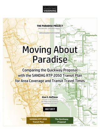
  • 1. THE CENTER FOR ADVANCED URBAN VISIONING THE PARADISE PROJECT IMPLEMENTING “TEMPORARY PARADISE?” DISCUSSION PAPER SERIES Moving About Paradise Comparing the Quickway Proposal with the SANDAG RTP 2050 Transit Plan for Area Coverage and Transit Travel Times The Quickway Proposal SANDAG RTP 2050 Transit Plan Alan S. Hoffman Lecturer in City Planning San Diego State University “Leadership Starts Here” JULY 2017
  • 2. Moving About Paradise Comparing the Quickway Proposal with the SANDAG RTP 2050 Transit Plan for Area Coverage and Transit Travel Times © 2017 by The Center for Advanced Urban Visioning (619) 232-1776 • urbanvisioning@outlook.com
  • 3. Foreward The maps in this paper highlight the differences in coverage and travel time between the RTP 2050 Transit Plan and the Quickway Proposal’s alternative plan for transit systems development. The questions that should guide the viewer of these maps include the following: 1. Which system would you be more likely to use? 2. Which network is more likely to be useful to residents of San Diego? 3. Which network would better serve the region, by attracting and serving more users, reducing traffic and parking impacts, and better anchoring new development?
  • 4. A Note on Coverage Maps The maps in this paper make a clear distinction between Rapid Transit and “Semi- Rapid Transit.” Rapid Transit is defined as a transit service that maintains a through- speed along most of its length of at least 18 mph during the AM commute. Much of the Trolley system averages 25-27 mph, clearly achieving Rapid Transit status. Rapid Bus routes are more problematic; those that operate on freeways meet the standard for Rapid Transit, but arterial operations are typically far short of 18 mph; for example, the Rapid Bus Route 215 on El Cajon Blvd averages about 12 mph from College Avenue through to University Avenue during the AM peak, far below the 18 mph threshold. While RTP-defined arterial Rapid Bus services are clearly Semi-Rapid Transit by our definition, what about services that operate as Rapid Transit along a dedicated guideway but then travel essentially as an arterial Rapid Bus, such as the Quickway Proposal’s MetroXpress Network? For those boarding or alighting at these stations/stops, they will experience their trip as closer to Rapid Transit than Semi- Rapid; as a result, the first three stations/stops on an arterial are depicted as halfway between Rapid Transit and Semi-Rapid, both for the RTP (such as in Kearny Mesa) or the Quickway Proposal (most MetroXpress routes).
  • 5. Contents 1. The Case for a New Transit Plan 2. The Quickway Proposal in Brief 3. Quickway 2025: The Mid-Coast Supportive Projects 4. Station Area Coverage • Uptown / North Park / City Heights • San Diego District 7 / Kearny Mesa / Linda Vista / Clairemont • PB / MB / Mission Bay • Point Loma / Peninsula • Downtown / Surrounding Communities • National City / Southeast • Chula Vista • Central Coastal North County / Carlsbad 5. Transit Travel Time Comparisons • AM Commute – Accessing Fashion Valley Transit Center • Quickway Proposal vs. Transit Today FOR MORE INFORMATION ON THE QUICKWAY PROPOSAL: View the introductory presentation: www.slideshare.net/UrbanVisioning/quickwayproposalintro Read the discussion paper “Preserving Paradise”: www.slideshare.net/UrbanVisioning/preserving-paradise-77620902 View maps and other project documents: www.quickwayproposal.wix.com/proposal
  • 6. THE PARADISE PROJECT IMPLEMENTING “TEMPORARY PARADISE?” DISCUSSION PAPER SERIES 1 Preserving Paradise: How a Better Connected San Diego Can Serve Residents, Reduce Traffic, and Save Taxpayers Money 2 Moving About Paradise: Comparing the Quickway Proposal with the SANDAG RTP 2050 Transit Plan for Area Coverage and Transit Travel Times
  • 7. 1 The Case for a New Transit Plan The case for a new transit plan can be summed up in 10 points. 1. Virtually all of the region’s growth plans revolve around transit. SANDAG’s growth plan is one example, calling for the vast majority of new housing to be located within ½ mile of a “high frequency” transit route.1 Transit is expected to absorb a significant share of trips from new development. For transit to attract these new riders, it must be perceived as convenient, affordable, safe, fast, and attractive. The better a job transit does at meeting these standards, the more effective it will be at attracting new riders, attracting more station-area development, and moving enough people to significantly relieve pressure off the automotive/road side. 2. For San Diego to meet ambitious Climate Action Plan and Smart Growth targets, many trips will need to shift toward transit and other modes. Regional long-range goals require that many automobile trips be shifted onto transit. This is why our regional growth strategies call for locating new development near transit. If a transit system could significantly increase its contribution toward these targets for a comparable—perhaps even cheaper— cost, it would make sense to pursue the possibility. 3. Transit investments in San Diego have so far failed to attract the people that must be attracted to transit: middle-income people who commute by car. There is considerable evidence to back up this claim. a. The Trolley doesn’t attract a broader demographic than the city bus. For both Trolley and MTS Bus, over half of all riders hail from households with annual incomes below $35,000; about 80% are from households earning less than $50,000.2 b. The Trolley attracts relatively few people who otherwise would have driven. About 64% of Trolley riders did not have access to a car for their trip, only marginally better than the 72% of bus riders who lacked auto access.3 1 “High-frequency transit” includes city bus routes that operate at a 15 minute frequency, regardless of actual expected travel times to desired locations. 2 These figures from SANDAG’s 2015 Onboard Passenger Survey, p. 16. The average income of the poorest riders has increased relative to 2009, but the percent of riders from households earning under $50,000/year is unchanged. 3 This represents a slight improvement over 2009 data (65% Trolley and 75% Bus). Source: SANDAG 2015 Onboard Passenger Survey, p. 10.
  • 8. 2 c. According to the US Census, the use of transit in San Diego has been trending downward. Even more troubling, carpooling—the basis of SANDAG’s massive investments in HOV and managed lanes—has decreased by a third, the largest decrease of any transportation mode.4 4. Our current regional transit plans are unlikely to meet modal shift goals. SANDAG’s current plans, after spending more than $20 billion on new projects and over $100 billion total on transit—would reduce the amount of time the average transit trip takes by only about 19%, cutting a 60 minute commute to 48.6 minutes—an improvement, certainly, but still generally uncompetitive with the automobile. The more competitive time-wise transit is with driving, especially among and between key destinations and areas with easy access to residences or higher residential densities, and the better a job transit does of improving the customer experience (current station design exposes riders to rain, hot sun, cold winds, and moving vehicles) the more likely it is to meet and exceed modal shift goals—or allow more ambitious ones to become realistic options. 5. Transit must be better located, significantly faster, more frequent, offer a better experience, and be easier/more convenient to use, if the goal is to attract many more riders. These points are reinforced in the New York-based Transitcenter’s study, “Who’s On Board 2016,” available at http://transitcenter.org/publications/whos-on-board-2016/–a “must-read” for anyone interested in improving the effectiveness of transit. The key findings of this study5 were: a. The most important “first mile/last mile” solution is walking. The majority of transit riders, including 80 percent of all-purpose riders, typically walk to transit. This finding underscores the importance of putting transit stations in busy, walkable neighborhoods; building offices and housing within walking distance of transit; and providing more and safer pedestrian routes to transit. b. The two most important determinants of rider satisfaction with transit are service frequency and travel time. The availability of information and conditions at the station or stop were also important, suggesting that real-time information and shelters are important amenities for transit agencies to provide. c. There are three common patterns of transit use:  Occasional riders who take transit once in a while,  Commuters who take transit regularly but only for work,  and all-purpose riders who take transit regularly for multiple purposes. Transit agencies should strive to grow this third category of rider, as they are the most reliable and financially efficient customers to serve. All-purpose riders are more prevalent where it’s easy to walk to transit, and where transit is frequent and provides access to many destinations. 4 Managed and HOV lanes are a core SANDAG transportation strategy; their disappointing impact on carpooling may be taken as evidence that the strategy is mismatched to actual travel needs. 5 Source: http://transitcenter.org/publications/whos-on-board-2016/#how-people-use-transit. Emphasis added.
  • 9. 3 d. Transit riders are sensitive to transit quality, not “captive” to transit. Who’s On Board finds that the “captivity” of carless riders is severely overstated. People who live and work near better transit ride transit more often, whether or not they own cars. When transit becomes functionally useless, there are very few people who will continue to use it; agencies can take no one for granted. 6. Failure to achieve transit goals imperils our future prosperity and quality of life. Communities often oppose new development because of traffic and parking impacts. This dynamic is one factor behind our current housing shortfall; we need to be building 14-15,000 dwelling units a year to meet market demand, but are building only around 6,000/year.6 This leaves families and individuals stretched even thinner by rising rents, with employers looking at shifting jobs out of state, given their inability to pay wages that would permit employees to afford housing in San Diego’s real estate market. If communities experiencing significant growth pressures were provisioned with integrated infrastructure that improved existing conditions, created new public space and amenity, and that successfully managed parking and traffic impacts, then communities would be more receptive to new development. If a cost- effective means of creating this infrastructure can be devised, then the benefits to the region would be at a very large scale. 7. The solution to this problem is a more effective transit plan. A smarter transit plan:  Reaches into more urban centers,  Slashes travel time,  Reduces wait time and transfers,  Is more convenient to use, and  Features stations that provide better safety and comfort. The Quickway Proposal is such an alternative. It advocates a fundamentally different strategy for transit than that outlined in SANDAG’s Regional Transportation Plan (RTP); this strategy is detailed in Preserving Paradise, the first Discussion Paper in the Paradise Project series, and is briefly outlined in the next chapter of this paper. Extensive analysis of the proposal confirms the effectiveness of the Quickway Proposal as an alternative strategy: a. Ridership gains. Quickway Proposal transit ridership is projected to nearly double per invested dollar compared to SANDAG’s plan.7 6 There are many other factors that contribute to the housing shortfall, but a smarter transit strategy, designed to actually mitigate the impacts of new development, can make a notable difference in opening up more urban land for new housing. 7 This figure is interpolated from the ridership and capital cost analysis reported on in The Quickway Proposal: A Proposal for an Affordable and Effective Rapid Transit System for the Greater San Diego Region, available for download at http://quickwayproposal.wixsite.com/proposal/reports. Independent analysis of a similar strategy developed for the Metro Atlanta region also found a doubling in ridership per invested capital dollar compared to their official transit plan (source: Metro Atlanta Chamber of Commerce, et. al., Atlanta’s Transit Future: Market Research Results, February 2004).
  • 10. 4 b. Cost savings. Capital costs are projected to be several billion dollars less than our current plan (our capital cost model accurately projected costs on several projects across North America). c. Reduced subsidies. Projected reductions in operating subsidies of several billion by 2050. d. Development. The Quickway Proposal places real infrastructure in the heart of our most urbanized zones, mitigating the parking and traffic impacts of new and existing development. In essence, the Quickway Proposal is designed to produce the results spoken of by TransitCenter (in Point #5 above): better located, faster, more frequent, fewer transfers, more convenient, and with a superior customer experience. 8. The Quickway Proposal is a more effective plan and can be built in stages, each of which would provide an immediate benefit. The first elements of the Quickway Proposal proposed for development—The Mid-Coast Supportive Projects—are designed to increase ridership on new and existing Trolley lines, create an effective movement system within the urbanized core, and support areas experiencing development pressure where the right infrastructure can mitigate the effects of traffic and parking congestion. For about the projected cost of the Mid-Coast Trolley, the Mid-Coast Supportive Projects add twice as many rapid transit stations and about 90 arterial (“Rapid Bus”) stations built to a new, customer-friendly model. These projects will contribute more to climate change goals than any transit project in the current RTP. These projects are discussed in detail in Preserving Paradise; they are highlighted in Chapter Three of this report. 9. The Quickway Proposal integrates well with parallel infrastructure (bicycle, walking, etc.) and land use plans for several communities, creating synergies and solving real problems. Among these plans are the Uptown 2025 Proposal, which looks at creating infrastructure to mitigate ongoing development in the Uptown communities. This Proposal was endorsed by the Hillcrest Town Council and the Bankers Hill Community Group. By integrating road, parking, world-class bicycling, landscaping, and parklands/people space into a coherent whole, Uptown could become the poster community for how to achieve Climate Change Goals. Other such proposals are forthcoming and will be discussed in Discussion Paper #3 in the Paradise Project series. 10. The Quickway Proposal shows how the right transit infrastructure, backed by the right service plan, can better achieve our goals and notably improve regional quality of life.
  • 11. 5 The Quickway Proposal in Brief The Quickway Proposal is a strategy for creating a world-class and regionally effective transit system for San Diego. Unlike current plans—which rely on several new Trolley lines, and many new “Rapid Bus” lines (some freeway-running, most arterial-running)—the Quickway Proposal is designed to:  Better serve our denser, more urban neighborhoods,  Cut transit travel time by nearly 2/3,  Reduce operating subsidies,  Better support locations experiencing development pressures, and  Attract many more riders by offering a compelling and competitive alternative to driving from many more origins to many more destinations. 1. What are Quickways? Quickways are grade-separated transitways with the following characteristics:  Travel lanes. Between stations, they commonly feature a single travel lane in each direction;  Grade-separation, so all cross traffic (both auto and pedestrian) goes either over or under Quickways, like with a freeway;  Real “rapid transit” stations featuring passing lanes (to support express operations), typically spaced about a mile apart (closer in some areas, farther in others);  “SuperStations,” which are larger and at which passing express services stop (SuperStations are typically spaced 3-5 miles apart); and  Route structure. At least three kinds of transit lines/routes use Quickways: all-stop, trolley-like routes; MetroXpress routes that skip most intervening stops; and emergency services vehicles (the Quickway Proposal directly serves most major hospitals in the region). 2. Are Quickways “BRT” (Bus Rapid Transit)? Quickways are not a “BRT” (Bus Rapid Transit) proposal nor is the proposal even remotely about an unproductive rail vs. bus debate. Rather, the proposed strategy suggests a smarter way to evolve toward a “permanent” rapid transit system. It begins by using buses (much like our new Rapid Buses), but is designed to develop and grow into some other more advanced guided technology, such as rail, over time.
  • 12. 6 3. What are the core elements of the Quickway Proposal? The Quickway Proposal is designed to create a more pervasive and effective rapid transit system for the San Diego region. It targets our region’s most urban zones with rapid services and quality infrastructure so as to create a transit system that is significantly faster, goes more places, is more comfortable and convenient to use, and is ultimately cheaper to operate. It consists of the following elements:  Quickways. A core network of about 100 miles of Quickways, the majority of which are surface- running but still grade-separated to optimize transit flows and reduce operating costs.  Surface “T-Ways” (at-grade transitways) and bus lanes feeding into and off of the Quickway infrastructure.  Light rail extensions where these extensions make sense.  Streetcars. At least three new streetcar systems.  Improved stations, including a modular arterial station that provides better protection from the elements (sun, wind, and the occasional rain) as well as from moving vehicles.  “Satellite” entrances to stations, using automated vehicles operating like “horizontal elevators,” extending the effective reach of certain stations to get people much closer to origins and destinations with minimal waiting (per the illustration on the right, looking down at city blocks and streets).  Road improvements, often tied to transit projects, to provide greater capacity in areas experiencing strong growth pressure.  A new regional express system, MetroXpress, making it far faster for people to travel longer distances. The Quickway Proposal is also designed to integrate with related proposals to create significant new parklands and public spaces, as well as bicycle and pedestrian infrastructure. 4. What are “MetroXpress” routes? MetroXpress routes are the secret to the Quickway Proposal’s time savings compared to the RTP transit plan. Most MetroXpress routes begin as “Rapid Bus” routes along key arterials, albeit with improved arterial station facilities that provide better protection for passengers. Upon entering a Quickway, these routes stop at the first station, then proceed express to their destination, stopping only at “SuperStations,” enabling transfers to other MetroXpress routes. MetroXpress routes are based on the “Speedy” network of Curitiba, Brazil, and the CityXpress network of Brisbane, Australia. Such networks significantly reduce travel times and operating costs, all while attracting many more riders.
  • 13. 7 5. What is the migration path for Quickways? The Quickway strategy is threefold: 1. Target. Build Quickway infrastructure where it produces the greatest bang for the buck, 2. Connect. Build the connecting pieces over time, and then 3. Transform. Upconvert to some form of rail or other automated, guided technology. This illustration, from Preserving Paradise, explains the central strategy behind developing Quickways. The key point is that the Quickway Proposal does not in the least preclude the creation of an effective regional rail system; it rather suggests the strategy by which such a system may be evolved so that benefits accrue immediately and the region can enjoy a transit system optimized for San Diego. 6. Why “satellite entrances” at some stations? Anyone who has ever entered a subway station via an escalator or elevator has already used a “satellite entrance”; the surface entryway is actually to a mode (escalator or elevator) that then connects to the actual transit station. Satellite entrances extend the reach of a rapid transit station, significantly increasing access and attracting new riders. To work, they must feature extremely high frequencies and very short travel times between the satellite entrance and the main station. Satellite entrances in the Quickway Proposal are designed to support a 2-minute frequency or better using paired shuttles (2-3 minutes if only one vehicle is employed, which would be expected at times of low demand). These shuttles will most likely be autonomous (driverless) vehicles traveling along a dedicated pathway (one example of a commercially-deployed autonomous shuttle is pictured in the illustration explaining satellite operations). Shuttles offer the ability to offer point-to-point super-high frequency service at minimal operating cost. 7. Where are the first segments to be built? In the first stage, Quickway segments are built where they will produce the greatest benefit. Since it is impossible to build a rail segment here and another there—rail lines must be connected or trains cannot make the leap—it makes sense to use “Rapid Buses” to begin operations and then upgrade once continuous infrastructure is built. For example, two tunnel segments might be built on University Avenue, about a mile apart, under the centers of Hillcrest and North Park. Any Rapid Bus making this connection
  • 14. 8 would see travel time cut by a third with greater reliability and a vastly improved customer experience. To build this as rail would require continuous rail tracks connecting the two, doubling or tripling the initial investment required to create the connection (and precluding the operation of MetroXpress services, which branch off to multiple destinations at a significant travel time savings). Why does travel time savings matter so much? Because it is directly linked to ridership—the faster a transit route, the more people it attracts—and to costs. Costs in transit are driven primarily by time; the faster a given service, the cheaper it is to operate and the more trips you can get from a single vehicle. Add to that the increase in fare revenue due to new passengers, and a 1/3 reduction in time may have an oversized impact on that route (and others that connect with it). Taxpayers especially benefit from this “virtuous circle”: their investments in transit produce a greater return on investment, subsidy levels go down, and the larger strategic reasons for creating rapid transit are more successfully met. 8. What Quickway and related infrastructure is being proposed for different communities? Draft infrastructure and service maps are provided in Preserving Paradise, the initial Discussion Paper in the Paradise Project Series and are also available online (see above). In the coverage maps that follow in this document, Quickway and related alignments (and MetroXpress arterial corridors) are depicted as well. 9. How can I learn more about the Quickway Proposal?  Introductory Presentation, available for view at www.facebook.com/QuickwayProposal.  Discussion Paper, Preserving Paradise, compares & contrasts the Quickway Proposal with the SANDAG RTP transit plan: www.slideshare.net/UrbanVisioning/preserving-paradise-77620902.  Project Report & Maps at www.quickwayproposal.wix.com/proposal.
  • 15. 9 “Quickway 2025”: The Mid-Coast Supportive Projects A new Trolley line—the Mid-Coast Light Rail Project—is under construction in San Diego. This $2.17 billion effort will extend the Trolley from Old Town north alongside I-5 to UCSD and the Golden Triangle, adding nine new stations to the trolley network. The Quickway Proposal takes advantage of our region’s investments in light rail by, in part, feeding people to and from trolley stations from many more locations, more rapidly, and with a vastly improved station waiting experience. For example, destinations as significant as Hillcrest (and its two major hospitals), the Sharp Hospital complex, USD, Sea World, Belmont Park, OB, the Sports Arena, and PB’s Garnet Avenue are all within a few miles of the trolley, but otherwise are not served by true rapid transit. The Mid-Coast Supportive Projects are a set of infrastructure (Quickways, transit lanes, and stations) investments and new Rapid Bus routes (intended to eventually evolve into the MetroXpress network) that together create notable improvements: a. Amplify ridership on the new Mid-Coast line. They take people to and from the Mid-Coast Light Rail line under development, helping build significant new ridership for that $2.1 billion project. b. Amplify ridership on existing Trolley lines. They build off of and support existing Trolley lines, effectively extending their “rapid transit” range. For example, the proposed Uptown Quickway
  • 16. 10 would take Trolley riders from the Fashion Valley Transit Center directly and speedily to jobs at both the UCSD Hillcrest Hospital and the Scripps Mercy Hospital complex. c. Serve the urban core. They create an effective and useful rapid transit network in the central zone of the region. The projects support approximately 10 new Rapid Bus lines that operate faster than the current one on El Cajon Boulevard due to the provision of Quickway and surface transitway infrastructure. Our analysis suggests an average reduction of transit travel time to/from locations such as Hillcrest and Fashion Valley of 42-46%, significantly outperforming SANDAG’s current plans and making transit competitive with driving for many trips. d. Mitigate development pressures. They anchor new development by creating infrastructure (stations and rights of way) in areas currently experiencing intensive market demand. 805 Hazard Ctr Mission VlyCtr Rio Vista FentonPkwy Qualcomm Stadium Rancho Mission Mesa College Allied Health Kearny HS Trolley BarnPark Oregon Antique Row 33rd Hawley Blvd Cherokee Kensington Texas 30th 35th Boulevard ADAMS EL CAJON BLVD City Hts UNIVERSITY AVE FAIRMOUNTAVE 30thST Polk Arizona Dwight Upas Redwood Juniper Beech Grape PSA Wabash Cherokee 43rd City Hts Village Esteban Bahena Hilton Sheraton Scottish Rite TexasSt Mission City Scheidler CMNO DEL RIO SOUTH University Hts Howard Ave North Park Park & University SD Zoo/ Balboa Park Naval Medical Ctr Plazade Panama California Tower Upas Quince Laurel Hawthorne Beech Genesee Juvenile Court Mary Birch Childrens Sharp Memorial Mission VlyRd ViaAlta Civita RioBonito RiverRun Park & Market 12th & Imperial Gaslamp Central Gaslamp/ Convention Ctr Convention Ctr East Seaport Village Justice America Plaza CivicCtr C St 5th Ave Horton Plaza Hillcrest Center Mercy UCSD Hillcrest Hotel Circle Fashion Valley Bay Park Boardwalk SportsArena EastDr Hancock CountyHealth Midway Loma Dewey Womble Laning Nimitz Harbor Dr Shelter Island Dr Talbot Submarine Groton Famosa Slough Mentone Cape May Newport Del Monte Del Mar Ave Voltaire ROSECRANS Sea World Quivira Bahia BelmontPark Washington St Middletown County Ctr / Little Italy Santa Fe Depot Colusa USD County Ed Ctr YMCA Las Cumbres Franciscan Glidden Tait W Comstock Ulric TaitE CLAIREMONTDR Olney Lamont Ingraham CassS Bond Fanuel & Garnet CassN Crystal Pier GRAND AVE Morena / Linda Vista Old Town Tecolote Clairemont Drive PB Gateway LINDAVISTARD ULRICST LEGEND Trolley (Light Rail) Future “SuperStation” (Direct Express Stops) Bus Infrastructure (Quickway, T-Way, Bus Lanes) Freeway- Running Arterial Rapid Bus “Trolley or Bus Station/Stop Transfer Point Route Terminus FriarsMission Chalcedony TURQUOISE MissionBlvd Cass Fanuel Ingraham & Garnet City College Uptown District
  • 17. Station Area Coverage UPTOWN / NORTH PARK / CITY HEIGHTS: AC1 Current Rapid & Semi-Rapid Transit AC2 RTP 2050 Rapid & Semi-Rapid Transit AC3 Quickway 2025 Rapid & Semi-Rapid Transit AC4 Quickway 2050 Rapid & Semi-Rapid Transit SAN DIEGO DISTRICT 7 / KEARNY MESA / LINDA VISTA / CLAIREMONT: AC5 Current Rapid & Semi-Rapid Transit AC6 RTP 2050 Rapid & Semi-Rapid Transit AC7 Quickway 2025 Rapid & Semi-Rapid Transit AC8 Quickway 2050 Rapid & Semi-Rapid Transit PB / MB / MISSION BAY: AC9 Quickway 2050 Rapid & Semi-Rapid Transit POINT LOMA / PENINSULA: AC10 Quickway 2050 Rapid & Semi-Rapid Transit DOWNTOWN / SURROUNDING COMMUNITIES: AC11 Current Rapid & Semi-Rapid Transit AC12 RTP 2050 Rapid & Semi-Rapid Transit AC13 Quickway 2050 Rapid & Semi-Rapid Transit NATIONAL CITY / SOUTHEAST: AC14 Current Rapid & Semi-Rapid Transit AC15 RTP 2050 Rapid & Semi-Rapid Transit AC16 Quickway 2050 Rapid & Semi-Rapid Transit CHULA VISTA: AC17 Current Rapid & Semi-Rapid Transit AC18 RTP 2050 Rapid & Semi-Rapid Transit AC19 Quickway 2050 Rapid & Semi-Rapid Transit CENTRAL COASTAL NORTH COUNTY / CARLSBAD: AC20 Current Rapid & Semi-Rapid Transit AC21 RTP 2050 Rapid & Semi-Rapid Transit AC22 Quickway 2050 Rapid & Semi-Rapid Transit The maps in the following section depict the land area within a ¼ mile radius of a station on the Rapid Transit or semi-rapid transit networks as they exist today, as proposed in the Regional Transportation Plan (RTP 2050), and as recommended in the Quickway Proposal. In some cases, a map depicts coverage under Phase I of the Quickway Proposal (Quicwkay 2025) to show how incremental investments are targeted in order to better gauge the effectiveness of the strategy. For the RTP, station/stop locations are not given in the RTP; they were located best on familiarity with previous SANDAG station location decisions. They may or may not represent current thinking on station location. It is also worth noting that a large share of land within a ¼ mile radius of a station is not actually within a ¼ mile walk, so the number of residents within a five-minute, or ¼ mile walk of a station will be less than those within the ¼ mile radius.
  • 18. UPTOWN/NORTH PARK/CITY HEIGHTS Current Rapid & Semi-Rapid Transit Area within ¼ mile radius of: Rapid Transit station Semi-Rapid station within 3 stops of becoming Rapid Transit Semi-Rapid Transit Station Streetcar stop Existing (and under construction) transit projects in Uptown / North Park / City Heights feature one semi-rapid route (the 215 “Rapid Bus,” which according to the schedule posted on www.sdmts.com is four minutes faster than the 30 minute trip for the local bus departing College & El Cajon Blvd at or near 8 am and arriving at Park Blvd & University Ave. on a weekday, a 13% travel time improvement at an average through-speed of 12 mph) and freeway-running routes on the I-15 corridor. Though a dedicated busway under construction on I-15 will speed buses through Mid-City, they will still be subject to delay north of I-8. Either way, most residents are beyond ¼ mile of a station. AC1
  • 19. UPTOWN/NORTH PARK/CITY HEIGHTS RTP 2050 Rapid & Semi-Rapid Transit Area within ¼ mile radius of: Rapid Transit station Semi-Rapid station within 3 stops of becoming Rapid Transit Semi-Rapid Transit Station Streetcar stop At build-out, the 2050 Regional Transportation Plan (RTP) calls for light rail along El Cajon Boulevard, rapid buses along University Avenue, Adams Avenue/Park Boulevard, and Bachman Drive, and streetcars on 30th Street and making a Hillcrest loop with downtown via Balboa Park. Since streetcar is generally a slow mode, it is not counted as rapid or even semi-rapid transit. While most residents of these communities will have access to at least semi-rapid transit, relatively few will have access to true Rapid Transit, and for those traveling to places like Mission Valley or the beach communities, travel times will still be excessive. AC2 LIGHT RAIL SURFACE BUSWAY STREETCAR RAPID BUS
  • 20. UPTOWN/NORTH PARK/CITY HEIGHTS Quickway 2025 Rapid & Semi-Rapid Transit Area within ¼ mile radius of: Rapid Transit station Semi-Rapid station within 3 stops of becoming Rapid Transit Semi-Rapid Transit Station Streetcar stop The first phase of the Quickway Proposal anticipates the construction of transit tunnels and other right of way serving the heart of North Park and connecting the center of Hillcrest with Mission Valley (Fashion Valley). These infrastructure pieces make several Rapid Bus lines feasible, due to the time savings and enhanced customer facilities. True Rapid Transit infrastructure and stations now serve the major trip attractors (the two key hospitals as well as the centers of both North Park and Hillcrest). Connections to the Trolley are vastly improved, as well as to much of Mission Valley. The vast majority of residents have access to at least semi-rapid transit. AC3 TUNNEL SURFACE BUSWAY ELEVATED
  • 21. UPTOWN/NORTH PARK/CITY HEIGHTS Quickway 2050 Rapid & Semi-Rapid Transit Area within ¼ mile radius of: Rapid Transit station Semi-Rapid station within 3 stops of becoming Rapid Transit Semi-Rapid Transit Station Streetcar stop In the Quickway Proposal, the majority of the residents of these densely populated communities now enjoy access to true Rapid Transit with routes branching to many key destinations throughout the region. Movement within these communities is also facilitated. A prime innovation in this network is the use of automated, self-guiding shuttles to extend the reach of many Rapid Transit stations with super-high frequency connections; the design goal is to treat these as “horizontal elevators” leading directly into stations. Designed effectively, these are a very low-cost means of significantly improving the effectiveness and attractiveness of Rapid Transit services to residents and visitors alike. AC4
  • 22. CITY OF SAN DIEGO DISTRICT 7 / KEARNY MESA / LINDA VISTA / CLAIREMONT Current Rapid & Semi-Rapid Transit Area within ¼ mile radius of: Rapid Transit station Semi-Rapid station within 3 stops of becoming Rapid Transit Semi-Rapid Transit Station Streetcar stop This vast area is served by light rail in Mission Valley and by Rapid Bus routes cutting through part of Kearny Mesa and Mid-City. N/S freeways in this zone congest up early in the pm commute. AC5
  • 23. CITY OF SAN DIEGO DISTRICT 7 / KEARNY MESA / LINDA VISTA / CLAIREMONT RTP 2050 Rapid & Semi-Rapid Transit Area within ¼ mile radius of: Rapid Transit station Semi-Rapid station within 3 stops of becoming Rapid Transit Semi-Rapid Transit Station Streetcar stop This area is subject to significant new Rapid Transit and semi-rapid transit in the RTP. Three Trolley lines are anticipated to converge in Kearny Mesa. Still, Mission Valley receives practically no improvements, and relatively few new Rapid Transit stations serve residents. While service is improved relative to existing services, it still falls far short of being useful for most residents. AC6
  • 24. CITY OF SAN DIEGO DISTRICT 7 / KEARNY MESA / LINDA VISTA / CLAIREMONT Quickway 2025 Rapid & Semi-Rapid Transit Area within ¼ mile radius of: Rapid Transit station Semi-Rapid station within 3 stops of becoming Rapid Transit Semi-Rapid Transit Station Streetcar stop projects in this phase are intended to extend the reach and utility of the Trolley, building ridership on both Trolley and Quickway services. AC7 The first stage of Quickway development amplifies the Trolley’s utility to Mission Valley, in addition to targeting Mesa College, Linda Vista, USD, and the Bay Park community; in fact, virtually all Quickway
  • 25. CITY OF SAN DIEGO DISTRICT 7 / KEARNY MESA / LINDA VISTA / CLAIREMONT Quickway 2050 Rapid & Semi-Rapid Transit Area within ¼ mile radius of: Rapid Transit station Semi-Rapid station within 3 stops of becoming Rapid Transit Semi-Rapid Transit Station Streetcar stop The full Quickway Proposal for this zone shows extensive coverage; virtually all of Mission Valley and Kearny Mesa enjoy access to Rapid Transit, as well as enhanced portions of Clairemont and Tierrasanta, while other communities enjoy more extensive access to semi-rapid transit that is well-integrated with the Rapid Transit network. Large numbers of residents have access to this system. AC8
  • 26. PACIFIC BEACH / MISSION BEACH / MISSION BAY Quickway 2050 Rapid & Semi-Rapid TransitArea within ¼ mile radius of: Rapid Transit station Semi-Rapid station within 3 stops of becoming Rapid Transit Semi-Rapid Transit Station Streetcar stop The 2050 RTP anticipates either a light rail or aerial tramway extension into PB, likely necessitating transfers to reach most regional destinations, along with a Rapid Bus route. Both bypass Garnet Avenue, the actual heart (and key destination) of the community. The Quickway Proposal extends Rapid Transit access to most residents of lower PB and provides direct connections to more likely destinations. In addition, two proposed streetcar routes facilitate movement within the community, as well as connections to Rapid Transit. SANDAG 2050 RTP anticipates a light rail line and a Rapid Bus line serving PB. AC9
  • 27. POINT LOMA / PENINSULA COMMUNITIES Quickway 2050 Rapid & Semi-Rapid Transit Area within ¼ mile radius of: Rapid Transit station Semi-Rapid Transit Station The RTP anticipates extending two semi- rapid (Rapid Bus) routes into these communities (see inset), where they will be subject to the same congestion and traffic delays that beset auto travel. The Quickway Proposal’s infrastructure bypasses most congested zones, allowing transit to become competitive with driving options. Many residents enjoy access to Rapid and semi-rapid transit. SANDAG 2050 TRANSIT PLAN Rapid Bus lines are depicted in thick, lighter blue lines. Both lines connect to Old Town Station. Note: This map was produced before the convention of marking semi-rapid stops within 3 stops of becoming Rapid Transit was adopted. This map also indicates where Quickway infrastructure is underground (brown), elevated (blue), or surface- running (yellow). AC10
  • 28. DOWNTOWN / SURROUNDING COMMUNITIES Current Rapid & Semi-Rapid Transit Area within ¼ mile radius of: Rapid Transit station Semi-Rapid station within 3 stops of becoming Rapid Transit Semi-Rapid Transit Station Streetcar stop While Downtown generally enjoys good access to Rapid Transit, surrounding communities generally don’t. AC11
  • 29. DOWNTOWN / SURROUNDING COMMUNITIES RTP 2050 Rapid & Semi-Rapid Transit Area within ¼ mile radius of: Rapid Transit station Semi-Rapid station within 3 stops of becoming Rapid Transit Semi-Rapid Transit Station Streetcar stop The RTP anticipates replacing the current Route 215 Rapid Bus with light rail, though it’s not clear how that would work on Park Boulevard. Otherwise, it relies on streetcar to improve connectivity in Park West, Golden Hill, and South Park. Compared to today, no additional residential zones would gain access to Rapid or semi- rapid transit. AC12
  • 30. DOWNTOWN / SURROUNDING COMMUNITIES Quickway 2050 Rapid & Semi-Rapid Transit Area within ¼ mile radius of: Rapid Transit station Semi-Rapid station within 3 stops of becoming Rapid Transit Semi-Rapid Transit Station Streetcar stop Compared to the RTP, the Quickway Proposal creates a more extensive streetcar network in the core and extends Rapid Transit to serve much of the Park West community, which is experiencing considerable high rise residential development. AC13
  • 31. NATIONAL CITY & SOUTHEAST COMMUNITIES Current Rapid & Semi-Rapid Transit Area within ¼ mile radius of: Rapid Transit station Semi-Rapid station within 3 stops of becoming Rapid Transit Semi-Rapid Transit Station Streetcar stop This area is currently served by the Trolley along the Bayfront and by the Orange Line heading east. The South Bay BRT Project under construction will eventually use I-805 and SR-94 to connect with Downtown San Diego. AC14
  • 32. NATIONAL CITY & SOUTHEAST COMMUNITIES RTP 2050 Rapid & Semi-Rapid Transit Area within ¼ mile radius of: Rapid Transit station Semi-Rapid station within 3 stops of becoming Rapid Transit Semi-Rapid Transit Station Streetcar stop A new light rail line, the Purple Line, is proposed by SANDAG to run through the heart of the South Bay cities, through Mid- City San Diego, and into Kearny Mesa. Access to Rapid or Semi-Rapid Transit still remains somewhat limited, and the Purple Line will not make travel to points west easy or quick. AC15
  • 33. NATIONAL CITY & SOUTHEAST COMMUNITIES Quickway 2050 Rapid & Semi-Rapid Transit Area within ¼ mile radius of: Rapid Transit station Semi-Rapid station within 3 stops of becoming Rapid Transit Semi-Rapid Transit Station Streetcar stop The Quickway Proposal anticipates a more flexible set of infrastructure investments that about double effective access to Rapid or semi-rapid transit. Travel times to many key destinations are significantly improved in the Quickway Proposal, easing access to far more of the region’s job opportunities. AC16
  • 34. CHULA VISTA Current Rapid & Semi-Rapid Transit Area within ¼ mile radius of: Rapid Transit station Semi-Rapid station within 3 stops of becoming Rapid Transit Semi-Rapid Transit Station Streetcar stop Chula Vista is currently served by one Trolley line (with three stations in the city). A BRT project is under construction in Otay Ranch that will provide a connection into Downtown via I-805; though useful, it will still be subject to the congestion that overtakes even the HOV lanes during peak commuting times (especially in the AM inbound). Direct access by residents to Rapid Transit is limited to very few. AC17
  • 35. NATIONAL CITY & SOUTHEAST COMMUNITIES RTP 2050 Rapid & Semi-Rapid Transit Area within ¼ mile radius of: Rapid Transit station Semi-Rapid station within 3 stops of becoming Rapid Transit Semi-Rapid Transit Station Streetcar stop The RTP anticipates a new Trolley line, the Purple Line, traveling through the heart of Chula Vista, and a new Rapid Bus line on the H Street corridor. Though both will be useful additions compared to current services, most residents remain beyond walking access from Rapid or semi-rapid transit. AC18
  • 36. NATIONAL CITY & SOUTHEAST COMMUNITIES Quickway 2050 Rapid & Semi-Rapid Transit Area within ¼ mile radius of: Rapid Transit station Semi-Rapid station within 3 stops of becoming Rapid Transit Semi-Rapid Transit Station Streetcar stop Compared to the RTP, the Quickway Proposal extends access to both Rapid and semi-rapid Transit to a much larger share of Chula Vista’s residents and destinations. Travel times within Chula Vista are improved, as well as access to regional destinations, most of which will be brought much closer to Chula Vista. AC19
  • 37. CENTRAL NORTH COUNTY COASTAL / CARLSBAD Current Rapid & Semi-Rapid Transit Area within ¼ mile radius of: Rapid Transit station Semi-Rapid station within 3 stops of becoming Rapid Transit Semi-Rapid Transit Station Streetcar stop This zone is served by a single Coaster station. AC20
  • 38. CENTRAL NORTH COUNTY COASTAL / CARLSBAD RTP 2050 Rapid & Semi-Rapid Transit Area within ¼ mile radius of: Rapid Transit station Semi-Rapid station within 3 stops of becoming Rapid Transit Semi-Rapid Transit Station Streetcar stop This zone is served by a single Coaster station and two Rapid Bus lines. Access is still quite limited, particularly to the employment zone of Palomar Airport Road. AC21
  • 39. CENTRAL NORTH COUNTY COASTAL / CARLSBAD Quickway 2050 Rapid & Semi-Rapid Transit Area within ¼ mile radius of: Rapid Transit station Semi-Rapid station within 3 stops of becoming Rapid Transit Semi-Rapid Transit Station Streetcar stop Both El Camino Real (south of the airport) and Palomar Airport Road are grade- separated, freeing right of way for transit and removing considerable pressure off I-5 and even SR78. Access to Rapid Transit is enhanced, and many employers are now directly served by Rapid Transit and semi-rapid transit, along key destinations such as the Flower Fields, Legoland, and the outlet mall. AC22
  • 40. Travel Time Comparisons AM COMMUTE – ACCESSING FASHION VALLEY TRANSIT CENTER TT1 – Stations within 10 minutes of Fashion Valley TT2 – Stations within 20 minutes of Fashion Valley TT3-TT8 – Stations within 30 minutes of Fashion Valley TT9 – RTP 2050 station areas within 10 minutes of Fashion Valley TT10 – Quickway Proposal station areas within 10 minutes of Fashion Valley TT11 – RTP 2050 station areas within 20 minutes of Fashion Valley TT12 – Quickway Proposal station areas within 20 minutes of Fashion Valley TT13 – Stations within 20 minutes of Fashion Valley matched to 2050 Employment & Residential Density TT14 – Station areas within 10 minutes of Fashion Valley TT15 – Station areas within 20 minutes of Fashion Valley TT16 – Station areas within 30 minutes of Fashion Valley QUICKWAY PROPOSAL VS TRANSIT TODAY TT17 – North County TT18 – Central & East County TT19 – South County REGIONAL ACCESS: MISSION VALLEY: KEARNY MESA:
  • 41. Rapid Transit Stations / Stops within of the Fashion Valley Transit Station SANDAG 2050 RTP QUICKWAY PROPOSAL # of STATIONS: 12 72 Station/Stop within 10 minutes Weekday travel to Fashion Valley for 8:30 am arrival PLEASE NOTE: THESE MAPS ARE APPROXIMATE DEPICTIONS. CENTRAL SAN DIEGO Stations within 10 Minutes of Fashion Valley Six times as many stations are within 10 minutes of Fashion Valley in the Quickway Proposal, including many in residential zones that generate a lot of Mission Valley trips. Travel times to Fashion Valley during the AM commute were calculated for both the RTP and the Quickway Proposal. Fashion Valley was chosen as a destination due to its centrality in the region and its importance as a transfer center. TT1
  • 42. SANDAG 2050 RTP QUICKWAY PROPOSAL # of STATIONS: 56 263 Rapid Transit Stations / Stops within of the Fashion Valley Transit Station Station/Stop within 10 minutes Station/Stop within 20 minutes Weekday travel to Fashion Valley for 8:30 am arrival PLEASE NOTE: THESE MAPS ARE APPROXIMATE DEPICTIONS. CENTRAL SAN DIEGO Stations within 20 Minutes of Fashion Valley Five times as many stations are within 20 minutes of Fashion Valley in the Quickway Proposal, including much of Mid-City and many dozens of stations north of Aero Drive as far as Mira Mesa. Travel times to Fashion Valley during the AM commute were calculated for both the RTP and the Quickway Proposal. Fashion Valley was chosen as a destination due to its centrality in the region and its importance as a transfer center. TT2
  • 43. SANDAG 2050 RTP QUICKWAY PROPOSAL # of STATIONS: 115 458 Rapid Transit Stations / Stops within of the Fashion Valley Transit Station Station/Stop within 10 minutes Station/Stop within 20 minutes Station/Stop within 30 minutes Weekday travel to Fashion Valley for 8:30 am arrival PLEASE NOTE: THESE MAPS ARE APPROXIMATE DEPICTIONS. TT3 CENTRAL SAN DIEGO Stations within 30 Minutes of Fashion Valley Four times as many stations are within 30 minutes of Fashion Valley in the Quickway Proposal, including much of the South Bay, the Golden Triangle, beach communities, Kearny Mesa, Mira Mesa, and Scripps Ranch. Travel times to Fashion Valley during the AM commute were calculated for both the RTP and the Quickway Proposal. Fashion Valley was chosen as a destination due to its centrality in the region and its importance as a transfer center.
  • 44. SANDAG 2050 RTP QUICKWAY PROPOSAL # of STATIONS: 115 458 Rapid Transit Stations / Stops within of the Fashion Valley Transit Station Weekday travel to Fashion Valley for 8:30 am arrival Areas within ¼ mile of a Rapid or Semi- Rapid Transit station or stop. PLEASE NOTE: THESE MAPS ARE APPROXIMATE DEPICTIONS. TT4 CENTRAL SAN DIEGO Stations within 30 Minutes of Fashion Valley In these views, areas within a ¼ mile radius of each station within 30 minutes of Fashion Valley are depicted by an aerial view. For the Quickway Proposal, it is possible to recognize many parts of the region. Travel times to Fashion Valley during the AM commute were calculated for both the RTP and the Quickway Proposal. Fashion Valley was chosen as a destination due to its centrality in the region and its importance as a transfer center.
  • 45. SANDAG 2050 RTP QUICKWAY PROPOSAL # of STATIONS: 115 458 Rapid Transit Stations / Stops within of the Fashion Valley Transit Station Weekday travel to Fashion Valley for 8:30 am arrival Areas within ¼ mile of a Rapid or Semi- Rapid Transit station or stop. PLEASE NOTE: THESE MAPS ARE APPROXIMATE DEPICTIONS. TT5 CENTRAL SAN DIEGO Stations within 30 Minutes of Fashion Valley In these views, areas within a ¼ mile radius of each station within 30 minutes of Fashion Valley are depicted by an aerial view. For the Quickway Proposal, it is possible to recognize many parts of the region. Travel times to Fashion Valley during the AM commute were calculated for both the RTP and the Quickway Proposal. Fashion Valley was chosen as a destination due to its centrality in the region and its importance as a transfer center.
  • 46. Base map: “2050 Housing and Employment Densities and Urban Area Transit Strategy Boundary” (SANDAG, San Diego Forward: The Regional Plan, 2016, p. 37). 2050 Employment & Housing Densities CENTRAL SAN DIEGO SANDAG’s 2050 Regional Transportation Plan (RTP) anticipates the regional distribution of jobs and housing; most new housing is anticipated to be multi-family near “frequent transit service,” though that transit may just be a local bus every 15 minutes with poor connectivity to those jobs. TT6
  • 47. Base map: “2050 Housing and Employment Densities and Urban Area Transit Strategy Boundary” (SANDAG, San Diego Forward: The Regional Plan, 2016, p. 37). RTP 2050 Stations within of Fashion Valley Matched to 2050 Employment & Housing Densities CENTRAL SAN DIEGO While many of the stations that are within 30 minutes by transit of Fashion Valley in the RTP are surrounded by jobs, they represent only a small portion of the jobs in the central zone. TT7
  • 48. Base map: “2050 Housing and Employment Densities and Urban Area Transit Strategy Boundary” (SANDAG, San Diego Forward: The Regional Plan, 2016, p. 37). Quickway Stations within of Fashion Valley Matched to 2050 Employment & Housing Densities CENTRAL SAN DIEGO The Quickway Proposal brings many more jobs and residences closer to Fashion Valley than the RTP. Similar results may be expected for most locations in the region. Why wouldn’t we pursue a strategy that provides superior connectivity? TT8
  • 50. PLEASE NOTE: THESE MAPS ARE APPROXIMATE DEPICTIONS. 2050 RTP PLEASE NOTE: THESE MAPS ARE APPROXIMATE DEPICTIONS. TRAVEL TIMES CALCULATED FOR WEEKDAY COMMUTE, ARRIVAL BY 8:30 AM. TT9 MISSION VALLEY RTP 2050 Stations within 10 Minutes of Fashion Valley The only real improvements planned for Mission Valley in the RTP are Rapid Bus lines to Linda Vista and Hillcrest. Otherwise, most of Mission Valley, including most office employment and most residents, are not directly served. Travel times to Fashion Valley during the AM commute were calculated for both the RTP and the Quickway Proposal. Fashion Valley was chosen as a destination due to its centrality in the region and its importance as a transfer center.
  • 51. Quickway Proposal PLEASE NOTE: THESE MAPS ARE APPROXIMATE DEPICTIONS. TRAVEL TIMES CALCULATED FOR WEEKDAY COMMUTE, ARRIVAL BY 8:30 AM. 10MINUTES TT10 MISSION VALLEY Quickway 2050 Stations within 10 Minutes of Fashion Valley The Quickway Proposal specifies infrastructure to speed transit services into, out of, and through Mission Valley. Large areas of both Mission Valley and surrounding communities (North Park, Hillcrest, and Linda Vista) and brought wihin 10 minutes of Fashion Valley. Travel times to Fashion Valley during the AM commute were calculated for both the RTP and the Quickway Proposal. Fashion Valley was chosen as a destination due to its centrality in the region and its importance as a transfer center.
  • 52. 2050 RTP PLEASE NOTE: THESE MAPS ARE APPROXIMATE DEPICTIONS. TRAVEL TIMES CALCULATED FOR WEEKDAY COMMUTE, ARRIVAL BY 8:30 AM. TT11 MISSION VALLEY RTP 2050 Stations within of Fashion Valley Very few additional stations are brought within 20 minutes of Fashion Valley compared to 10 minutes in the RTP 2050 Transit Plan. Most of the office jobs and residences in Mission Valley are not within ¼ mile of Rapid or semi-rapid transit. Travel times to Fashion Valley during the AM commute were calculated for both the RTP and the Quickway Proposal. Fashion Valley was chosen as a destination due to its centrality in the region and its importance as a transfer center.
  • 53. Quickway Proposal PLEASE NOTE: THESE MAPS ARE APPROXIMATE DEPICTIONS. TRAVEL TIMES CALCULATED FOR WEEKDAY COMMUTE, ARRIVAL BY 8:30 AM. TT12 MISSION VALLEY Quickway 2050 Stations within of Fashion Valley The vast majority of Mission Valley is within 20 minutes of Fashion Valley in the Quickway Proposal, as well as much of North Park, University Heights, Normal Heights, Linda Vista, and other nearby communities. The combination of faster travel times and much broader area coverage make the Quickway network more useful to more people. Travel times to Fashion Valley during the AM commute were calculated for both the RTP and the Quickway Proposal. Fashion Valley was chosen as a destination due to its centrality in the region and its importance as a transfer center.
  • 54. MISSION VALLEY Rapid & Semi- Rapid Transit Stations within of Fashion Valley… …Matched to 2050 Employment & Density TT13 Quickway Proposal 2050 RTP
  • 56. Kearny Mesa QUICKWAY PROPOSAL From no part of Kearny Mesa does rapid or semi-rapid transit get you to Fashion Valley in 10 minutes or less during the AM commute. The Sharp Hospital District, much of Convoy, and even Clairemont Mesa Boulevard are within 10 minutes of Fashion Valley. SANDAG RTP 2050 PLAN Areas within 10MINUTES by Rapid or Semi- Rapid Transit of the Fashion Valley Transit Station PLEASE NOTE: THESE MAPS ARE APPROXIMATE DEPICTIONS. TRAVEL TIMES CALCULATED FOR WEEKDAY COMMUTE, ARRIVAL BY 8:30 AM. KEARNY MESA Station Areas within 10 minutes of Fashion Valley: SANDAG 2050 RTP Plan vs the Quickway Proposal TT14
  • 57. Most of Kearny Mesa, parts of Clairemont and Serra Mesa, and Mesa College are all within 20 minutes of Fashion Valley. The northern part of the Sharp Hospital District and a busy corner in Kearny Mesa are within 20 minutes of Fashion Valley. Kearny Mesa QUICKWAY PROPOSALSANDAG RTP 2050 PLAN Areas within by Rapid or Semi- Rapid Transit of the Fashion Valley Transit Station PLEASE NOTE: THESE MAPS ARE APPROXIMATE DEPICTIONS. TRAVEL TIMES CALCULATED FOR WEEKDAY COMMUTE, ARRIVAL BY 8:30 AM. KEARNY MESA Station Areas within of Fashion Valley: SANDAG 2050 RTP Plan vs the Quickway Proposal TT15
  • 58. Kearny Mesa QUICKWAY PROPOSAL Some locations in Kearny Mesa are now within a 30 minute rapid or semi- rapid transit trip of Fashion Valley. Most of the rest of Kearny Mesa is now served. SANDAG RTP 2050 PLAN Areas within by Rapid or Semi- Rapid Transit of the Fashion Valley Transit Station PLEASE NOTE: THESE MAPS ARE APPROXIMATE DEPICTIONS. TRAVEL TIMES CALCULATED FOR WEEKDAY COMMUTE, ARRIVAL BY 8:30 AM. KEARNY MESA Station Areas within of Fashion Valley: SANDAG 2050 RTP Plan vs the Quickway Proposal TT16
  • 59. Regional Travel Please note: Travel times calculated in 2014. Ongoing improve- ments to both the current network and the Quickway Proposal may have shifted some times (for example, current travel time from the Escondido Transit Center to Sorrento Mesa has been reduced from 62 to 61 minutes).
  • 60. NORTH COUNTY Quickway Proposal Projected Travel Times vs Current Transit Travel TImes TT17 Please note: Travel times calculated in 2014. Ongoing improvements to both the current network and the Quickway Proposal may have shifted some times (for example, current travel time from the Escondido Transit Center to Sorrento Mesa has been reduced from 62 to 61 minutes).
  • 61. CENTRAL & EAST COUNTY Quickway Proposal Projected Travel Times vs Current Transit Travel TImes TT18
  • 62. SOUTH COUNTY Quickway Proposal Projected Travel Times vs Current Transit Travel TImes TT19