Lizard Island - the Making of (FME Overview)
•Download as PPTX, PDF•
0 likes•1,272 views

This document promotes FME software and its capabilities. It discusses FME's ability to connect, transform, and automate data from a wide variety of formats. These include geospatial formats like CAD, GIS, rasters, point clouds, and web services as well as non-geospatial formats like tables. The document also describes FME Server and FME Cloud for automating data movement and sharing.

Recommended
Recommended
More Related Content
Similar to Lizard Island - the Making of (FME Overview)
Similar to Lizard Island - the Making of (FME Overview) (16)
More from Safe Software
More from Safe Software (20)
Recently uploaded
Recently uploaded (20)
Lizard Island - the Making of (FME Overview)
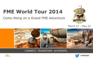
- 1. CONNECT. TRANSFORM. AUTOMATE. FME World Tour 2014 Come Along on a Grand FME Adventure #FMEWT March 27 – May 23
- 2. Welcome!
- 4. CONNECT. TRANSFORM. AUTOMATE. Lizard Island: The Making Of
- 5. Why we do what we do. You should be free to use whatever data you want. Your data shouldn’t be locked into systems, applications, or formats. Your time is too valuable to be wasted fighting with data. FME is all about Freedom. Freedom to get the most value from data everywhere.
- 6. What we do.
- 7. New to FME? Get your bearings from our Getting Started Page: www.safe.com/fme/getting-started Learn from our crew in one of the weekly FME Overview webinars: http://www.safe.com/WeeklyIntro
- 8. 20 years of FME formats 20 years of FME formats
- 9. It all started at S.A.I.F. Spatial Archive Interchange Format used for Terrain Resource Information Management (TRIM) http://fme.ly/saif
- 10. An explosion of formats! Always more Always faster.
- 11. FormatsFormats
- 12. Key Capability: Data Transformation ▪ Restructure and manipulate data contents
- 14. FME Server Provide Self-Serve Access FME Server brings the power of FME to the enterprise, with enhanced automation capabilities. Deliver Data How It’s Needed Automatically Move Data With FME Server You Can...
- 15. With FME Cloud You Can... FME Cloud Provide Self-Serve Access Welcome to a whole new way to deploy FME Server! Deliver Data How It’s Needed Automatically Move Data With FME Server You Can... FME Cloud is FME Server!
- 16. CONNECT. TRANSFORM. AUTOMATE. Moment of transition… Next up: Lizard Island: On Location FME Stories From Around the World
- 18. CAD GISCAD GIS
- 21. ID LONGITUDE LATITUDE CONDITION TYPE TYPE OF LUMINARE VOLTAGE WATTS CONTROL CENTER 1 82 59 26.098235061 - 41 30 43.068175401 + Good NAV RED INCANDESCENT 120/12 9.24 61 2 82 59 26.563977418 - 41 30 43.362121522 + Good NAV GRN INCANDESCENT 120/12 9.24 61 3 82 59 27.002814710 - 41 30 43.641866642 + Good NAV RED INCANDESCENT 120/12 9.24 61 4 82 59 27.463651489 - 41 30 43.939960952 + Good NAV GRN INCANDESCENT 120/12 9.24 61 5 82 59 27.905565366 - 41 30 44.219406077 + Good NAV RED INCANDESCENT 120/12 9.24 61 6 82 59 28.380990900 - 41 30 44.520466955 + Good NAV GRN INCANDESCENT 120/12 9.24 61 7 82 59 28.820540125 - 41 30 44.791771643 + Good NAV RED INCANDESCENT 120/12 9.24 61 TabularTabular
- 22. RasterRaster
- 25. CityGML Building Example <citymodel> <cityObjectMember> <Building gml:id="104167"> <gml:name>A house</gml:name> <boundedBy> <GroundSurface gml:id="8b7970ee"> <lod2MultiSurface> <gml:Polygon> <gml:exterior> <gml:LinearRing> <gml:posList>3477350.98 5551112.32 … gml:posList> </gml:LinearRing> </gml:exterior> </gml:Polygon> </lod2MultiSurface> </GroundSurface> </boundedBy> <boundedBy> <RoofSurface gml:id="fme-gen-4c”> … </citymodel> Web/XML/GMLWeb/XML/GML
- 26. 3D & BIM3D & BIM
- 27. RDS ArcGIS Online Google BigQuery CloudCloud
- 28. Internet of ThingsInternet of Things
- 29. Big DataBig Data
- 30. Video?Video? Skybox Imaging – SKYSAT1
- 31. The more things change, the more things stay the same.
- 33. Key Capability: Data Transformation ▪ Restructure and manipulate data contents
- 35. FME Server Provide Self-Serve Access FME Server brings the power of FME to the enterprise, with enhanced automation capabilities. Deliver Data How It’s Needed Automatically Move Data With FME Server You Can...
- 36. With FME Cloud You Can... FME Cloud Provide Self-Serve Access Welcome to a whole new way to deploy FME Server! Deliver Data How It’s Needed Automatically Move Data With FME Server You Can... FME Cloud is FME Server!
- 37. CONNECT. TRANSFORM. AUTOMATE. Moment of transition… Next up: Lizard Island: On Location FME Stories From Around the World
- 38. Demo:
Editor's Notes
- Learn about the new FME 2014 releaseGet new FME tips and best practicesMeet data experts from the local communityEnjoy free breakfast, lunch, and prizesSlides available online soon
- Agenda & Feedback FormWhat's Great in FME 2014 Brochure2014 FME Transformer Reference Guide$250 off FME UC Promo Offer CardFME 2014 Puzzle
- The different data contexts that FME supports
- And the very early version of FME is still available as the SAIF translator – see the link
- An explosion of format and the data contexts we work in – in the order we more or less added them to FME:CAD & GIS – still the bread and butter of Safe usersSpatial Databases – starting with SDE and Smallworld!Non-spatial – always been a part of FME but we’ve been focusing on this more – Excel, CSV. We could include Non_SQL databasesRaster – the first of the non-vector formats added to FMEPoint Cloud – the first of the massive datasetsWeb / XML / GML: huge advances in XML / GML in FME 20143D & BIM : Very complex hierarchical structures in CityGML, IFC, RevitCloud: could be cloud and big data : Amazon redshift, Amazon DynamoDB(No-SQL), Mark-Logic (No-SQL), Azure, AGOL, GME etc. Internet of ThingsWhat’s next? Video?Internet of Things: real time sensor type data. Mostly transmitted as XML or JSON
- A Wordle of the most popular formats. (log scale!!!)Geodatabase – in it’s many forms of enterprise, file and personal finally wins the format raceACAD in it’s many forms of AutoCAD, Civil 3d, Object data… a close second SHAPE is less common than it used to be!!! Used to be the clear leaderORACLE is a surprising runner up
- An explosion of format and the data contexts we work in – in the order we more or less added them to FME:CAD & GIS – still the bread and butter of Safe usersSpatial Databases – starting with SDE and Smallworld!Non-spatial – always been a part of FME but we’ve been focusing on this more – Excel, CSV. We could include Non_SQL databasesRaster – the first of the non-vector formats added to FMEPoint Cloud – the first of the massive datasetsWeb / XML / GML: huge advances in XML / GML in FME 20143D & BIM : Very complex hierarchical structures in CityGML, IFC, RevitCloud: could be cloud and big data : Amazon redshift, Azure, AGOL, GME etc.What’s next? Video?Internet of Things: real time sensor type data. Mostly transmitted as XML or JSON
- Behind all of this is the 400+ transformers used to support the wide range of systems FME supports.Still the most common transformers are the attribute manipulation transformation tools.
- The core of FME. CAD, GIS & Spatial DatabasesCAD – focus on layout and drawing clarity. Very particular about text placement and symbologyGIS – focus on attribution and analysis – data quality.
- Spatial databases – the ‘single source’ for GISComplex data modelsGeometryAttributionRelationshipsNetworksannotation
- FME’s first spatial database was SDE. Now it includes a wide variety of Geodatabase variants, Oracle , GE Smallworld
- All sorts of raster manipulation. DEM , tiling , reproject and in the middle classification and polygon formation
- ..and KML as well
- Amazon RDS, Google Big Table, Dynamo DB
- Behind all of this is the 400+ transformers used to support the wide range of systems FME supports.Still the most common transformers are the attribute manipulation transformation tools.