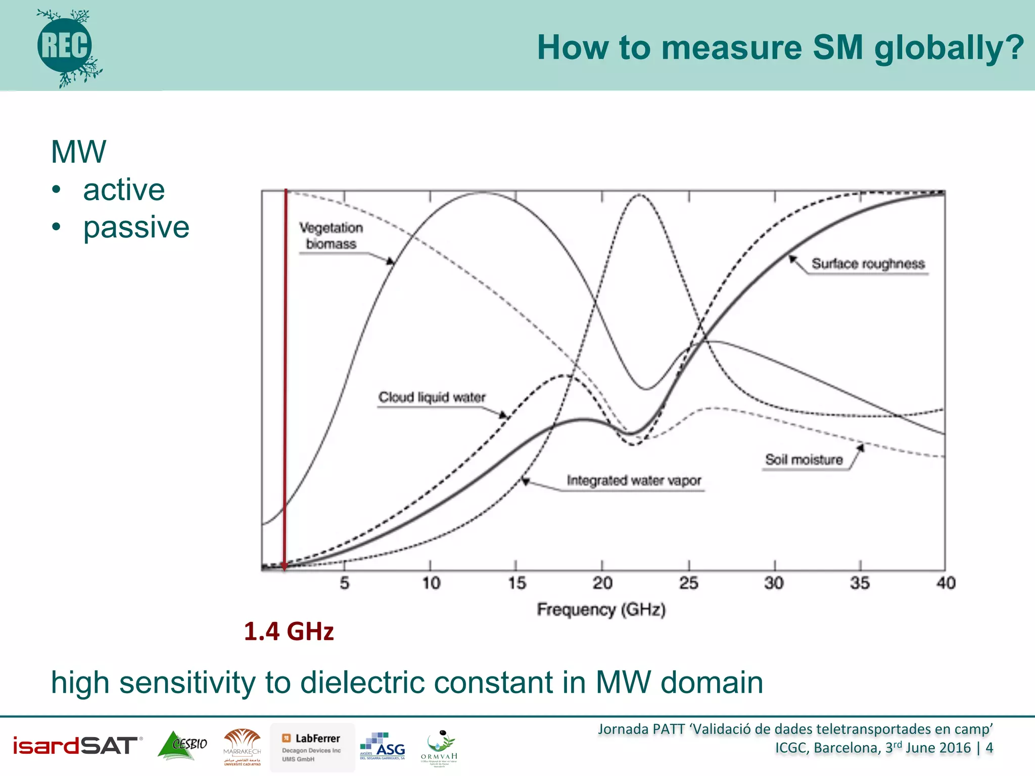
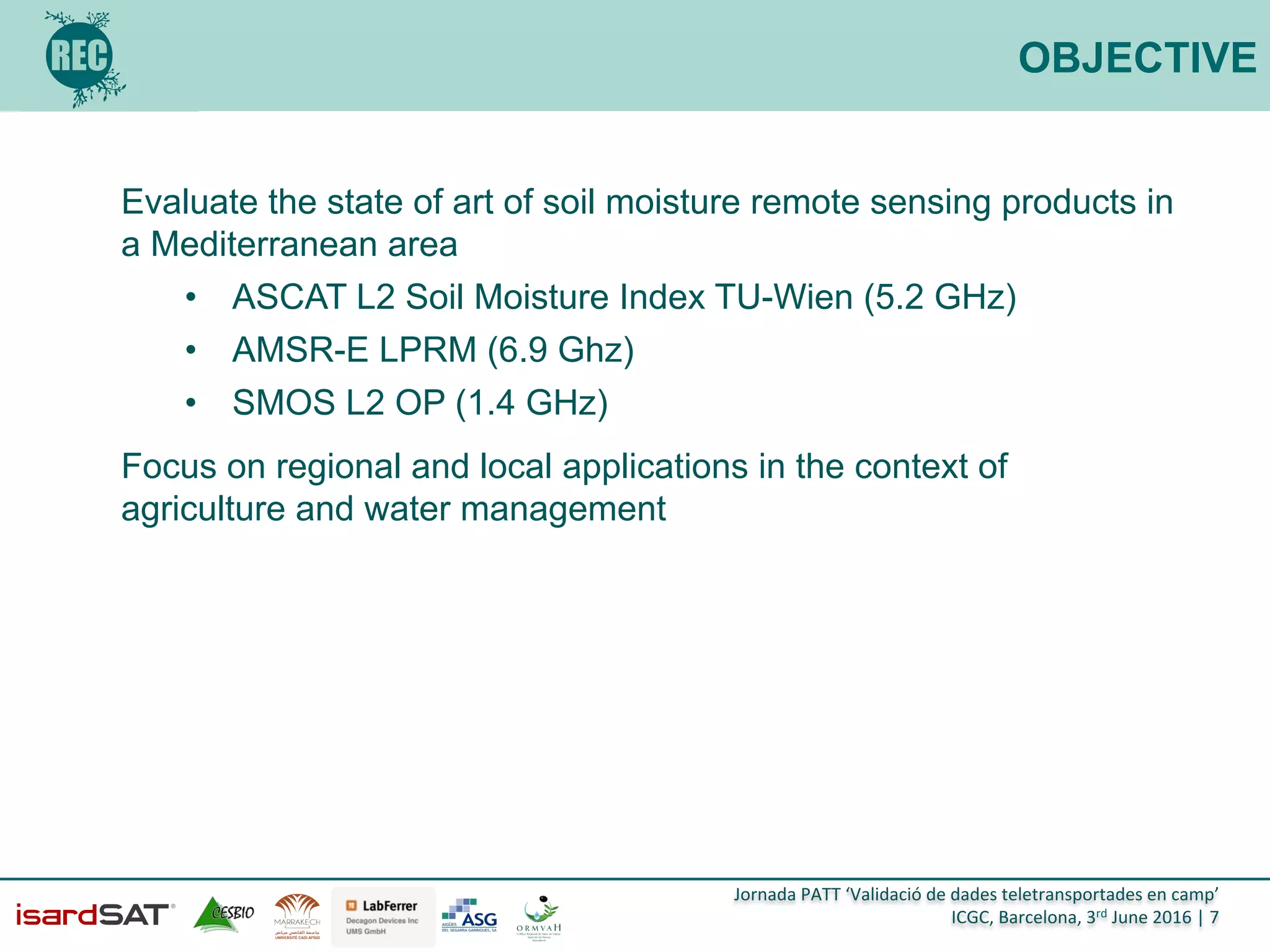
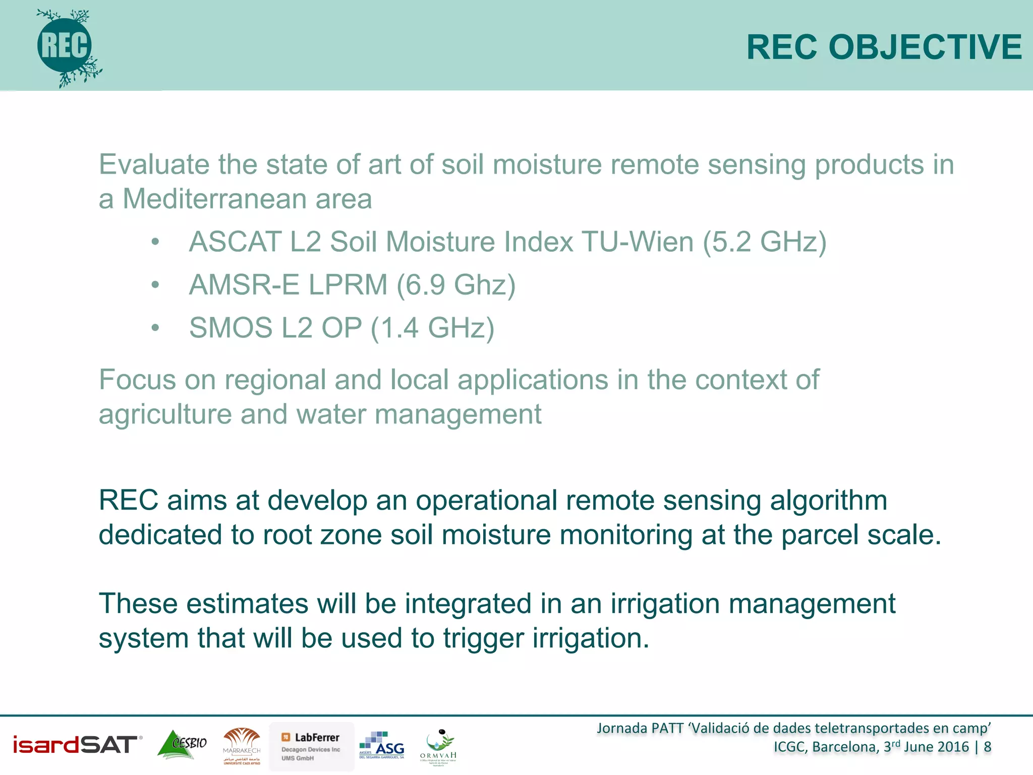
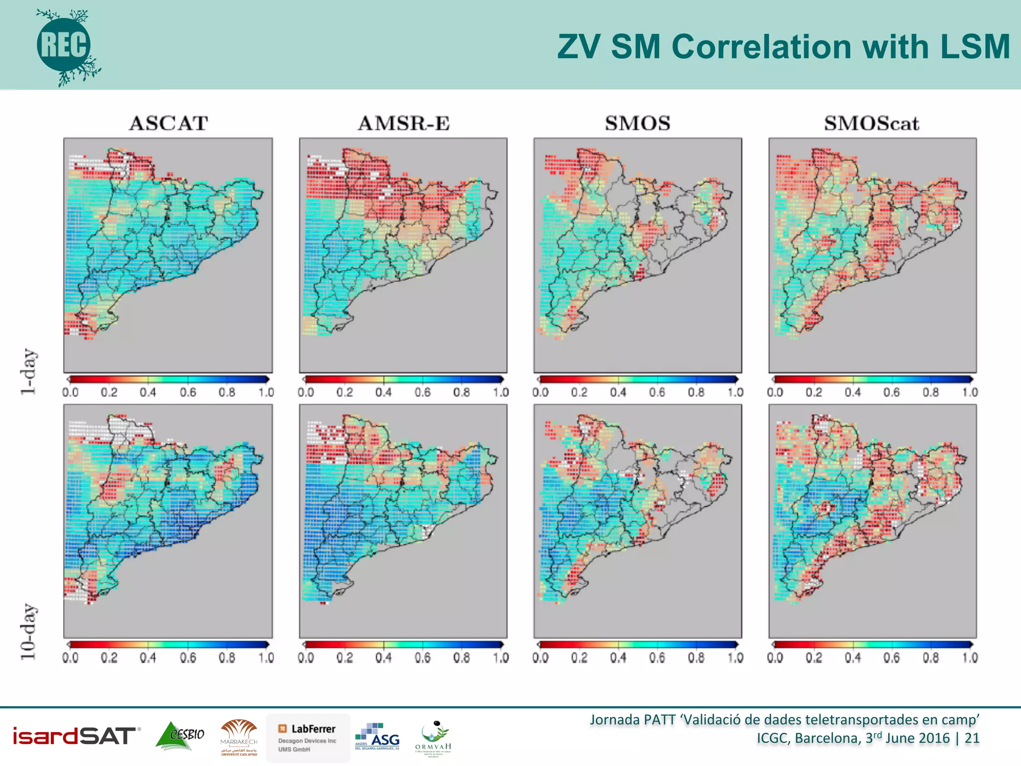
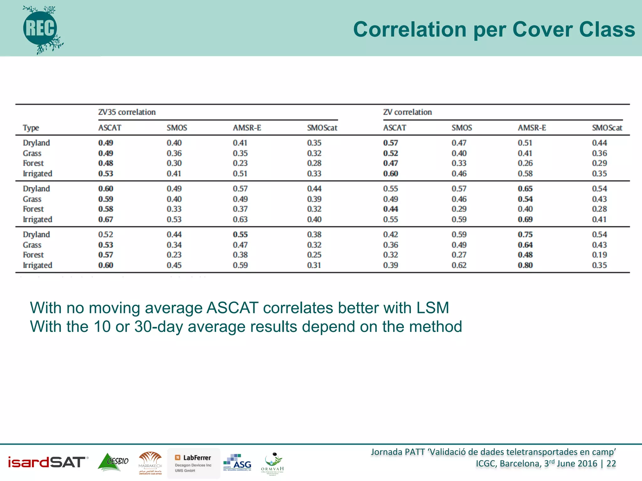
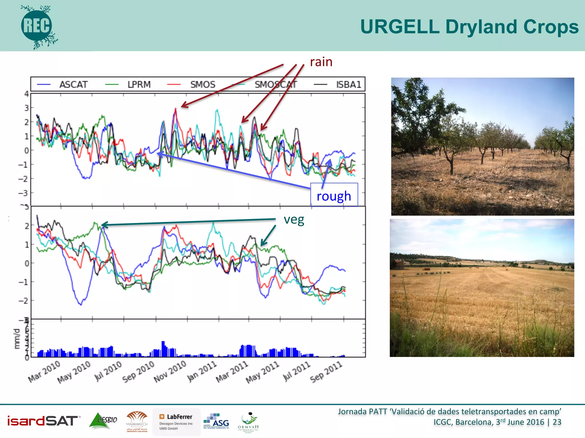
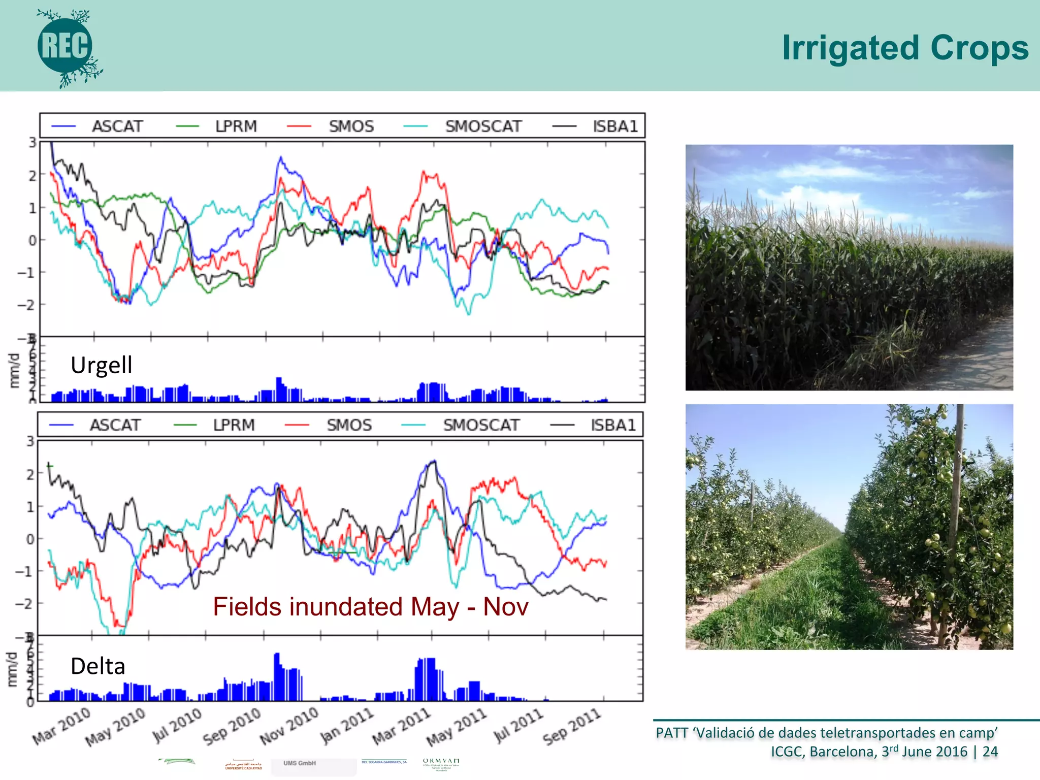
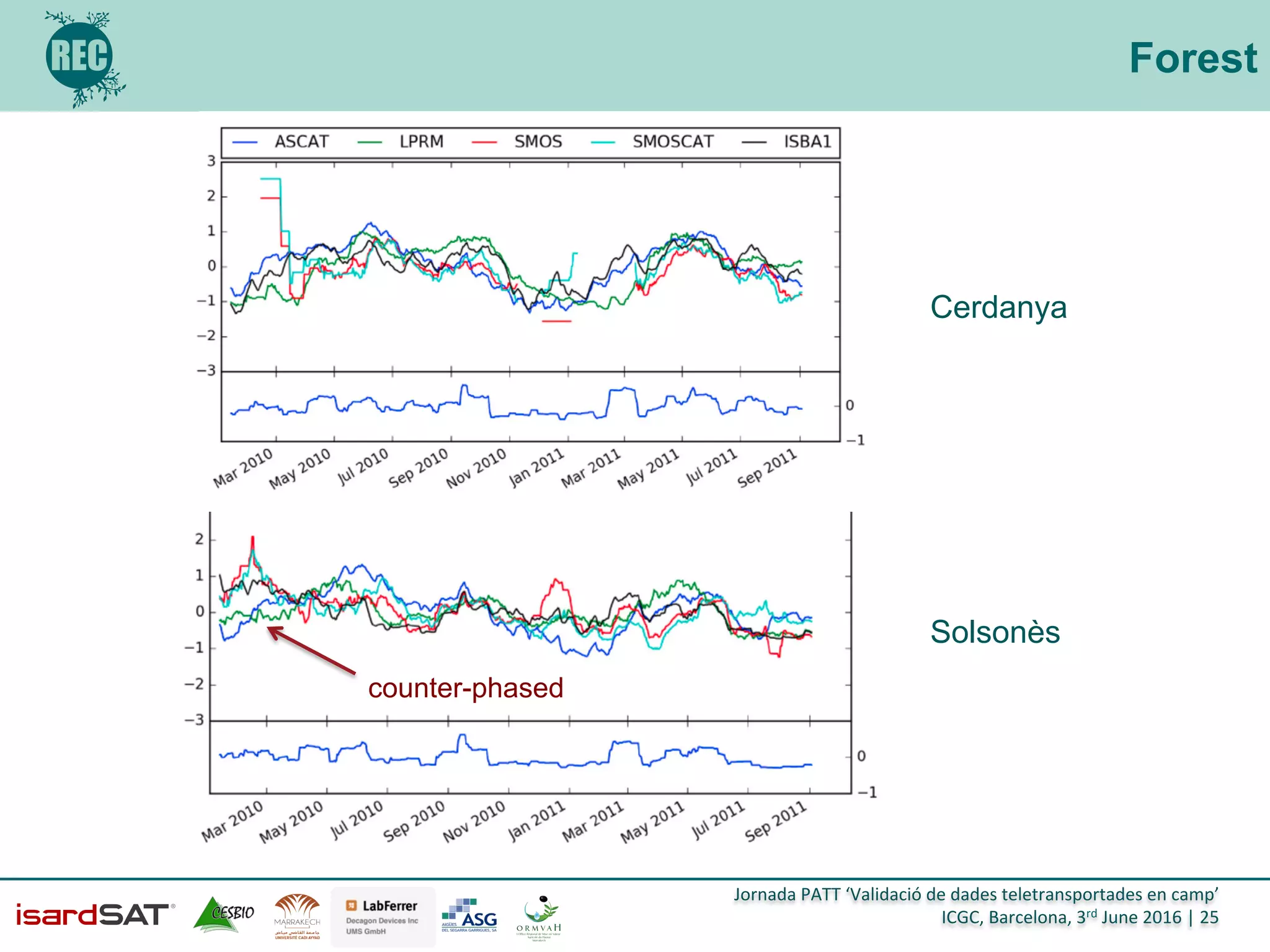
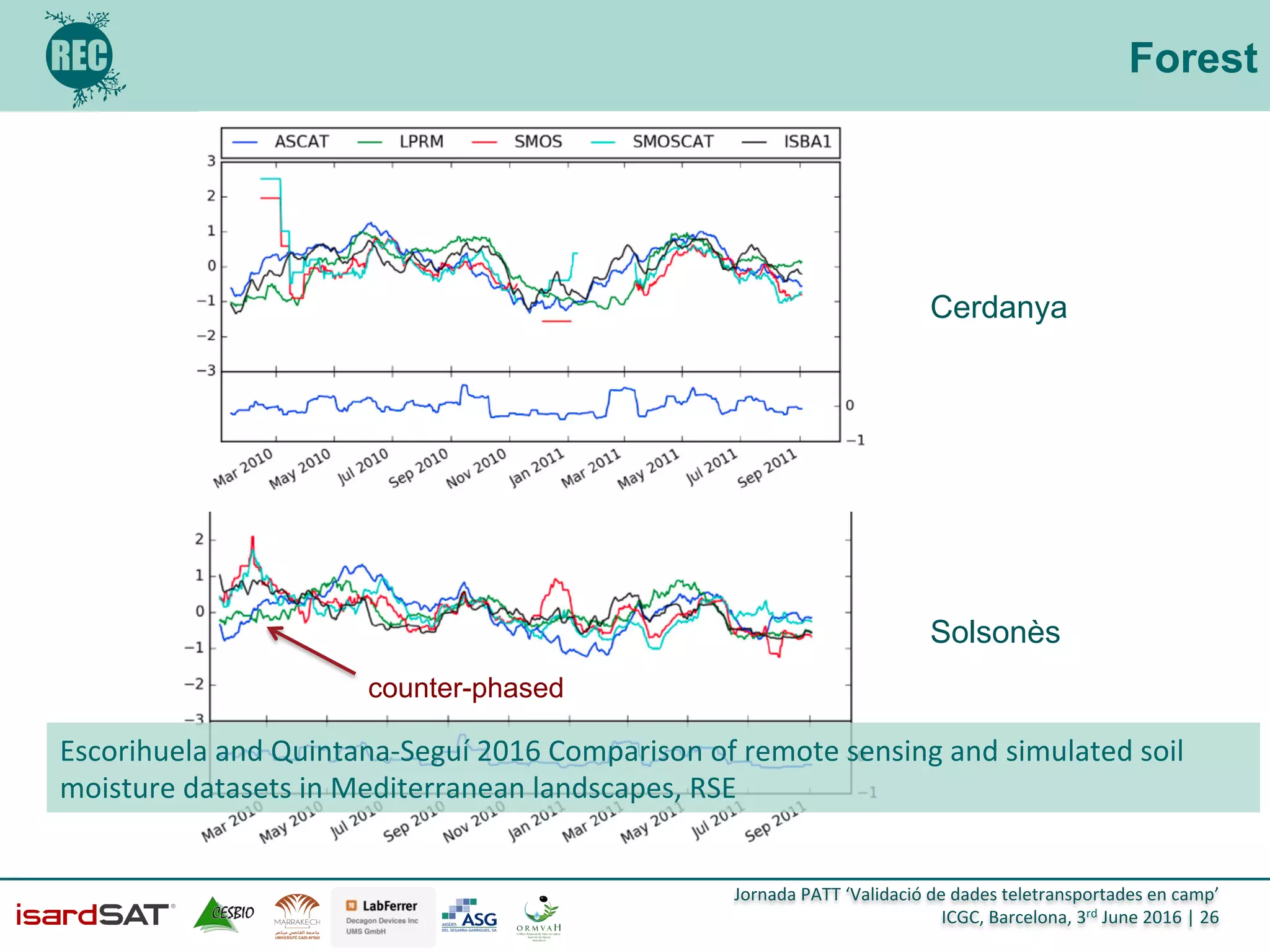
Jornada	
  PATT	
  ‘Validació	
  de	
  dades	
  teletransportades	
  en	
  camp’	
  
ICGC,	
  Barcelona,	
  3rd	
  June	
  2016	
  |	
  1	
  
Comparison of Remote
Sensing and Simulated Soil
Moisture Datasets across a
range of spatial resolution in
Mediterranean Landscapes
!
Maria Jose Escorihuela (1) Pere Quintana-
Seguí(2) ) and Olivier Merlin(2)
(1) isardSAT, (2) Observatori de l’Ebre, (3) CESBIO
H2020-MSCA-RISE-2014, 2015- 2019
Grant agreement no: 645642
Jornada	
  PATT	
  ‘Validació	
  de	
  dades	
  teletransportades	
  en	
  camp’	
  
ICGC,	
  Barcelona,	
  3rd	
  June	
  2016	
  |	
  2	
  
CONTEXT
Soil moisture is a critical variable in many physical processes related to
agriculture, hydrology, meteorology or climatology
The Mediterranean region is one of the most sensitive areas to climate
change
Agriculture uses up to 80% of water available in Mediterranean
countries
IPCC predictions, the change in precipitation patterns descend the
productivity of rainfed agriculture down to the 50% of its present value
towards 2020
Irrigation performance assessments at the field scale show a mismatch
between irrigation requirements and the amount of irrigation water that
is actually applied. Optimize on-farm irrigation management.
Jornada	
  PATT	
  ‘Validació	
  de	
  dades	
  teletransportades	
  en	
  camp’	
  
ICGC,	
  Barcelona,	
  3rd	
  June	
  2016	
  |	
  3	
  
Context
MicroWave	
   Thermal	
  
MicroWave	
  
Fluorescence	
   NDVI	
  
Jornada	
  PATT	
  ‘Validació	
  de	
  dades	
  teletransportades	
  en	
  camp’	
  
ICGC,	
  Barcelona,	
  3rd	
  June	
  2016	
  |	
  4	
  
How to measure SM globally?
MW
•  active
•  passive
high sensitivity to dielectric constant in MW domain
1.4	
  GHz	
  
Jornada	
  PATT	
  ‘Validació	
  de	
  dades	
  teletransportades	
  en	
  camp’	
  
ICGC,	
  Barcelona,	
  3rd	
  June	
  2016	
  |	
  5	
  
How to measure SM globally?
SMOS mission provides for the first time global mapping of
soil moisture from L- band (1.4 GHz) MW radiometry
•  soil moisture accuracy
0.04 m3m-3
•  biomass ≤ 5 kg m-2
•  spatial resolution better
than 50 km
•  revisit frequency of 2 to
3 days
•  crossing time over the
equator 6 am - 6 pm
Jornada	
  PATT	
  ‘Validació	
  de	
  dades	
  teletransportades	
  en	
  camp’	
  
ICGC,	
  Barcelona,	
  3rd	
  June	
  2016	
  |	
  6	
  
Passive MW L-band
November 2
2009
2017
January 31
2015
2020
before 2020 2025
SMOS	
  
SMAP	
  
WCOM	
  
Jornada	
  PATT	
  ‘Validació	
  de	
  dades	
  teletransportades	
  en	
  camp’	
  
ICGC,	
  Barcelona,	
  3rd	
  June	
  2016	
  |	
  7	
  
OBJECTIVE
Evaluate the state of art of soil moisture remote sensing products in
a Mediterranean area
•  ASCAT L2 Soil Moisture Index TU-Wien (5.2 GHz)
•  AMSR-E LPRM (6.9 Ghz)
•  SMOS L2 OP (1.4 GHz)
Focus on regional and local applications in the context of
agriculture and water management
Jornada	
  PATT	
  ‘Validació	
  de	
  dades	
  teletransportades	
  en	
  camp’	
  
ICGC,	
  Barcelona,	
  3rd	
  June	
  2016	
  |	
  8	
  
REC OBJECTIVE
Evaluate the state of art of soil moisture remote sensing products in
a Mediterranean area
•  ASCAT L2 Soil Moisture Index TU-Wien (5.2 GHz)
•  AMSR-E LPRM (6.9 Ghz)
•  SMOS L2 OP (1.4 GHz)
Focus on regional and local applications in the context of
agriculture and water management
REC aims at develop an operational remote sensing algorithm
dedicated to root zone soil moisture monitoring at the parcel scale.
These estimates will be integrated in an irrigation management
system that will be used to trigger irrigation.
	
  
Jornada	
  PATT	
  ‘Validació	
  de	
  dades	
  teletransportades	
  en	
  camp’	
  
ICGC,	
  Barcelona,	
  3rd	
  June	
  2016	
  |	
  9	
  
Disaggregation Methodology
20	
  cm	
  
0	
  -­‐	
  5	
  cm	
  
L-band Passive MW (40 km, 2/3 d)
+ Medium Resolution OT (1 km, 1 d)
+ High Resolution OT (100 m, 16 d)
SM (1 km, 2/3 d)
SM (100 m, 16 d)
D
I	
  
S
P
A
T
C
H	
  
Jornada	
  PATT	
  ‘Validació	
  de	
  dades	
  teletransportades	
  en	
  camp’	
  
ICGC,	
  Barcelona,	
  3rd	
  June	
  2016	
  |	
  10	
  
Urgell Field Campaign
Soil texture, stone percentage, wilting point
and field capacity
Once a month 2011 gravimetric SSM (0 – 5
cm) measurements:
Jornada	
  PATT	
  ‘Validació	
  de	
  dades	
  teletransportades	
  en	
  camp’	
  
ICGC,	
  Barcelona,	
  3rd	
  June	
  2016	
  |	
  11	
  
Urgell Field Campaign
DoY 146: 26 May 2011 DoY 244: 1 September 2011
Jornada	
  PATT	
  ‘Validació	
  de	
  dades	
  teletransportades	
  en	
  camp’	
  
ICGC,	
  Barcelona,	
  3rd	
  June	
  2016	
  |	
  12	
  
Validation 1km
Jornada	
  PATT	
  ‘Validació	
  de	
  dades	
  teletransportades	
  en	
  camp’	
  
ICGC,	
  Barcelona,	
  3rd	
  June	
  2016	
  |	
  13	
  
DisPATCh 100m
DoY 229: 17 August 2011
Jornada	
  PATT	
  ‘Validació	
  de	
  dades	
  teletransportades	
  en	
  camp’	
  
ICGC,	
  Barcelona,	
  3rd	
  June	
  2016	
  |	
  14	
  
DisPATCh 100m
DoY 277: 3 October 2011
Jornada	
  PATT	
  ‘Validació	
  de	
  dades	
  teletransportades	
  en	
  camp’	
  
ICGC,	
  Barcelona,	
  3rd	
  June	
  2016	
  |	
  15	
  
Validation 100m
O. Merlin, M. J. Escorihuela, M. Aran-Mayoral, O. Hagolle, A. Al Bitar, and Y. Kerr ''Self-calibrated evaporation-based
disaggregation of SMOS soil moisture: an evaluation study at 3 km and 100 m resolution in Catalunya, Spain'' Remote Sensing
of Environment, 130, pp 25–38, doi:10.1016/j.rse.2012.11.008, 2013
Jornada	
  PATT	
  ‘Validació	
  de	
  dades	
  teletransportades	
  en	
  camp’	
  
ICGC,	
  Barcelona,	
  3rd	
  June	
  2016	
  |	
  16	
  
Catalonia
NE Iberian Peninsula
Mediterranean climate
altitudes over 3,000 m
wide range of bioclimatic
habitats.
Jornada	
  PATT	
  ‘Validació	
  de	
  dades	
  teletransportades	
  en	
  camp’	
  
ICGC,	
  Barcelona,	
  3rd	
  June	
  2016	
  |	
  17	
  
Land-surface simulations
Model: SURFEX
•  Developed at Météo-France.
•  SURFEX is modular, we used the ISBA
3L scheme.
Spatial resolution: 5 km.
Time resolution: we decided to work with
daily series
Variable of interest:
•  we focused on the surface layer soil
wetness.
•  Satellite soil moisture products are
sensitive to the first few centimeters of
soil.
Simulation period:
1/9/2009 – 31/12/2011 (1 year spin-up)
Period of comparison with satellite data:
•  1 year: 2011
•  Therefore, initial conditions are not an
issue.
Masson et al., “The SURFEXv7.2 land and ocean surface
platform for coupled or offline simulation of earth surface
variables and fluxes,” Geosci. Model Dev., vol. 6, no. 4, pp. 929–
960, 2013.
Jornada	
  PATT	
  ‘Validació	
  de	
  dades	
  teletransportades	
  en	
  camp’	
  
ICGC,	
  Barcelona,	
  3rd	
  June	
  2016	
  |	
  18	
  
Land-surface simulations
The SAFRAN meteorological analysis
system was used to force the LSM.
Optimal interpolation.
First guess: HIRLAM HNR 5km.
Operational NWP model at AEMET.
Observed data: All available AEMET
meteorological stations.
SAFRAN analyses temperature, relative
humidity, precipitation, wind and cloudiness
and simulates downward short and long
wave radiation.
Temporal resolution: 6h (interpolated to
hourly series).
Spatial resolution: 5 km.
Quintana-Seguí et al. “Analysis of Near-Surface Atmospheric Variables:
Validation of the SAFRAN Analysis over France,” J. Appl. Meteorol. Climatol.,
vol. 47, pp. 92–107, 2008.
Jornada	
  PATT	
  ‘Validació	
  de	
  dades	
  teletransportades	
  en	
  camp’	
  
ICGC,	
  Barcelona,	
  3rd	
  June	
  2016	
  |	
  19	
  
Methodology
SM products in different units (m3m3, %) and each refer to different depths ->
data normalised
A moving average was applied to ZV or ZV35 to enhance soil moisture memory
and detect seasonal effects, two windows of 10 and 30 days were used
Correlations calculated for each grid point and agregated per cover class
Temporal series analysed over selected points representative of Mediterranean
landscapes: rainfed crops, irrigated crops, grass-shrubs and forest
Jornada	
  PATT	
  ‘Validació	
  de	
  dades	
  teletransportades	
  en	
  camp’	
  
ICGC,	
  Barcelona,	
  3rd	
  June	
  2016	
  |	
  20	
  
Cover Class
Jornada	
  PATT	
  ‘Validació	
  de	
  dades	
  teletransportades	
  en	
  camp’	
  
ICGC,	
  Barcelona,	
  3rd	
  June	
  2016	
  |	
  21	
  
ZV SM Correlation with LSM
Jornada	
  PATT	
  ‘Validació	
  de	
  dades	
  teletransportades	
  en	
  camp’	
  
ICGC,	
  Barcelona,	
  3rd	
  June	
  2016	
  |	
  22	
  
Correlation per Cover Class
With no moving average ASCAT correlates better with LSM
With the 10 or 30-day average results depend on the method 	
  
Jornada	
  PATT	
  ‘Validació	
  de	
  dades	
  teletransportades	
  en	
  camp’	
  
ICGC,	
  Barcelona,	
  3rd	
  June	
  2016	
  |	
  23	
  
URGELL Dryland Crops
rain	
  
veg	
  
rough	
  
Jornada	
  PATT	
  ‘Validació	
  de	
  dades	
  teletransportades	
  en	
  camp’	
  
ICGC,	
  Barcelona,	
  3rd	
  June	
  2016	
  |	
  24	
  
Irrigated Crops
Urgell	
  
Delta	
  
Fields inundated May - Nov
Jornada	
  PATT	
  ‘Validació	
  de	
  dades	
  teletransportades	
  en	
  camp’	
  
ICGC,	
  Barcelona,	
  3rd	
  June	
  2016	
  |	
  25	
  
Forest
Solsonès
Cerdanya
counter-phased
Jornada	
  PATT	
  ‘Validació	
  de	
  dades	
  teletransportades	
  en	
  camp’	
  
ICGC,	
  Barcelona,	
  3rd	
  June	
  2016	
  |	
  26	
  
Forest
Solsonès
Cerdanya
counter-phased
Escorihuela	
  and	
  Quintana-­‐Seguí	
  2016	
  Comparison	
  of	
  remote	
  sensing	
  and	
  simulated	
  soil	
  
moisture	
  datasets	
  in	
  Mediterranean	
  landscapes,	
  RSE	
  
Jornada	
  PATT	
  ‘Validació	
  de	
  dades	
  teletransportades	
  en	
  camp’	
  
ICGC,	
  Barcelona,	
  3rd	
  June	
  2016	
  |	
  27	
  
Summary and Conclusions
•  Soil Moisture products evaluated across different Mediterranean
landscapes
•  ASCAT correlates best with LSM, AMSR-E when seasonal behavior
enhanced
•  Over crops, ASCAT soil moisture increases from July to Novembre
probably due to increase of roughness (ploughing or increase of
penetration depth)
•  AMSR-E shows very high values of correlation but seems to be
correlated with vegetation cycle
•  SMOS is the only to see irrigation
•  Enhanced resolution (DisPATCh) is needed in Mediterranean
landscapes
Jornada	
  PATT	
  ‘Validació	
  de	
  dades	
  teletransportades	
  en	
  camp’	
  
ICGC,	
  Barcelona,	
  3rd	
  June	
  2016	
  |	
  28	
  
THANK YOU !
QUESTIONS?

Comparison of remote sensing soil moisture dataset across a range of spatial resolution Mediterranean landscape

  • 1.
    Jornada  PATT  ‘Validació  de  dades  teletransportades  en  camp’   ICGC,  Barcelona,  3rd  June  2016  |  1   Comparison of Remote Sensing and Simulated Soil Moisture Datasets across a range of spatial resolution in Mediterranean Landscapes ! Maria Jose Escorihuela (1) Pere Quintana- Seguí(2) ) and Olivier Merlin(2) (1) isardSAT, (2) Observatori de l’Ebre, (3) CESBIO H2020-MSCA-RISE-2014, 2015- 2019 Grant agreement no: 645642
  • 2.
    Jornada  PATT  ‘Validació  de  dades  teletransportades  en  camp’   ICGC,  Barcelona,  3rd  June  2016  |  2   CONTEXT Soil moisture is a critical variable in many physical processes related to agriculture, hydrology, meteorology or climatology The Mediterranean region is one of the most sensitive areas to climate change Agriculture uses up to 80% of water available in Mediterranean countries IPCC predictions, the change in precipitation patterns descend the productivity of rainfed agriculture down to the 50% of its present value towards 2020 Irrigation performance assessments at the field scale show a mismatch between irrigation requirements and the amount of irrigation water that is actually applied. Optimize on-farm irrigation management.
  • 3.
    Jornada  PATT  ‘Validació  de  dades  teletransportades  en  camp’   ICGC,  Barcelona,  3rd  June  2016  |  3   Context MicroWave   Thermal   MicroWave   Fluorescence   NDVI  
  • 4.
    Jornada  PATT  ‘Validació  de  dades  teletransportades  en  camp’   ICGC,  Barcelona,  3rd  June  2016  |  4   How to measure SM globally? MW •  active •  passive high sensitivity to dielectric constant in MW domain 1.4  GHz  
  • 5.
    Jornada  PATT  ‘Validació  de  dades  teletransportades  en  camp’   ICGC,  Barcelona,  3rd  June  2016  |  5   How to measure SM globally? SMOS mission provides for the first time global mapping of soil moisture from L- band (1.4 GHz) MW radiometry •  soil moisture accuracy 0.04 m3m-3 •  biomass ≤ 5 kg m-2 •  spatial resolution better than 50 km •  revisit frequency of 2 to 3 days •  crossing time over the equator 6 am - 6 pm
  • 6.
    Jornada  PATT  ‘Validació  de  dades  teletransportades  en  camp’   ICGC,  Barcelona,  3rd  June  2016  |  6   Passive MW L-band November 2 2009 2017 January 31 2015 2020 before 2020 2025 SMOS   SMAP   WCOM  
  • 7.
    Jornada  PATT  ‘Validació  de  dades  teletransportades  en  camp’   ICGC,  Barcelona,  3rd  June  2016  |  7   OBJECTIVE Evaluate the state of art of soil moisture remote sensing products in a Mediterranean area •  ASCAT L2 Soil Moisture Index TU-Wien (5.2 GHz) •  AMSR-E LPRM (6.9 Ghz) •  SMOS L2 OP (1.4 GHz) Focus on regional and local applications in the context of agriculture and water management
  • 8.
    Jornada  PATT  ‘Validació  de  dades  teletransportades  en  camp’   ICGC,  Barcelona,  3rd  June  2016  |  8   REC OBJECTIVE Evaluate the state of art of soil moisture remote sensing products in a Mediterranean area •  ASCAT L2 Soil Moisture Index TU-Wien (5.2 GHz) •  AMSR-E LPRM (6.9 Ghz) •  SMOS L2 OP (1.4 GHz) Focus on regional and local applications in the context of agriculture and water management REC aims at develop an operational remote sensing algorithm dedicated to root zone soil moisture monitoring at the parcel scale. These estimates will be integrated in an irrigation management system that will be used to trigger irrigation.  
  • 9.
    Jornada  PATT  ‘Validació  de  dades  teletransportades  en  camp’   ICGC,  Barcelona,  3rd  June  2016  |  9   Disaggregation Methodology 20  cm   0  -­‐  5  cm   L-band Passive MW (40 km, 2/3 d) + Medium Resolution OT (1 km, 1 d) + High Resolution OT (100 m, 16 d) SM (1 km, 2/3 d) SM (100 m, 16 d) D I   S P A T C H  
  • 10.
    Jornada  PATT  ‘Validació  de  dades  teletransportades  en  camp’   ICGC,  Barcelona,  3rd  June  2016  |  10   Urgell Field Campaign Soil texture, stone percentage, wilting point and field capacity Once a month 2011 gravimetric SSM (0 – 5 cm) measurements:
  • 11.
    Jornada  PATT  ‘Validació  de  dades  teletransportades  en  camp’   ICGC,  Barcelona,  3rd  June  2016  |  11   Urgell Field Campaign DoY 146: 26 May 2011 DoY 244: 1 September 2011
  • 12.
    Jornada  PATT  ‘Validació  de  dades  teletransportades  en  camp’   ICGC,  Barcelona,  3rd  June  2016  |  12   Validation 1km
  • 13.
    Jornada  PATT  ‘Validació  de  dades  teletransportades  en  camp’   ICGC,  Barcelona,  3rd  June  2016  |  13   DisPATCh 100m DoY 229: 17 August 2011
  • 14.
    Jornada  PATT  ‘Validació  de  dades  teletransportades  en  camp’   ICGC,  Barcelona,  3rd  June  2016  |  14   DisPATCh 100m DoY 277: 3 October 2011
  • 15.
    Jornada  PATT  ‘Validació  de  dades  teletransportades  en  camp’   ICGC,  Barcelona,  3rd  June  2016  |  15   Validation 100m O. Merlin, M. J. Escorihuela, M. Aran-Mayoral, O. Hagolle, A. Al Bitar, and Y. Kerr ''Self-calibrated evaporation-based disaggregation of SMOS soil moisture: an evaluation study at 3 km and 100 m resolution in Catalunya, Spain'' Remote Sensing of Environment, 130, pp 25–38, doi:10.1016/j.rse.2012.11.008, 2013
  • 16.
    Jornada  PATT  ‘Validació  de  dades  teletransportades  en  camp’   ICGC,  Barcelona,  3rd  June  2016  |  16   Catalonia NE Iberian Peninsula Mediterranean climate altitudes over 3,000 m wide range of bioclimatic habitats.
  • 17.
    Jornada  PATT  ‘Validació  de  dades  teletransportades  en  camp’   ICGC,  Barcelona,  3rd  June  2016  |  17   Land-surface simulations Model: SURFEX •  Developed at Météo-France. •  SURFEX is modular, we used the ISBA 3L scheme. Spatial resolution: 5 km. Time resolution: we decided to work with daily series Variable of interest: •  we focused on the surface layer soil wetness. •  Satellite soil moisture products are sensitive to the first few centimeters of soil. Simulation period: 1/9/2009 – 31/12/2011 (1 year spin-up) Period of comparison with satellite data: •  1 year: 2011 •  Therefore, initial conditions are not an issue. Masson et al., “The SURFEXv7.2 land and ocean surface platform for coupled or offline simulation of earth surface variables and fluxes,” Geosci. Model Dev., vol. 6, no. 4, pp. 929– 960, 2013.
  • 18.
    Jornada  PATT  ‘Validació  de  dades  teletransportades  en  camp’   ICGC,  Barcelona,  3rd  June  2016  |  18   Land-surface simulations The SAFRAN meteorological analysis system was used to force the LSM. Optimal interpolation. First guess: HIRLAM HNR 5km. Operational NWP model at AEMET. Observed data: All available AEMET meteorological stations. SAFRAN analyses temperature, relative humidity, precipitation, wind and cloudiness and simulates downward short and long wave radiation. Temporal resolution: 6h (interpolated to hourly series). Spatial resolution: 5 km. Quintana-Seguí et al. “Analysis of Near-Surface Atmospheric Variables: Validation of the SAFRAN Analysis over France,” J. Appl. Meteorol. Climatol., vol. 47, pp. 92–107, 2008.
  • 19.
    Jornada  PATT  ‘Validació  de  dades  teletransportades  en  camp’   ICGC,  Barcelona,  3rd  June  2016  |  19   Methodology SM products in different units (m3m3, %) and each refer to different depths -> data normalised A moving average was applied to ZV or ZV35 to enhance soil moisture memory and detect seasonal effects, two windows of 10 and 30 days were used Correlations calculated for each grid point and agregated per cover class Temporal series analysed over selected points representative of Mediterranean landscapes: rainfed crops, irrigated crops, grass-shrubs and forest
  • 20.
    Jornada  PATT  ‘Validació  de  dades  teletransportades  en  camp’   ICGC,  Barcelona,  3rd  June  2016  |  20   Cover Class
  • 21.
    Jornada  PATT  ‘Validació  de  dades  teletransportades  en  camp’   ICGC,  Barcelona,  3rd  June  2016  |  21   ZV SM Correlation with LSM
  • 22.
    Jornada  PATT  ‘Validació  de  dades  teletransportades  en  camp’   ICGC,  Barcelona,  3rd  June  2016  |  22   Correlation per Cover Class With no moving average ASCAT correlates better with LSM With the 10 or 30-day average results depend on the method  
  • 23.
    Jornada  PATT  ‘Validació  de  dades  teletransportades  en  camp’   ICGC,  Barcelona,  3rd  June  2016  |  23   URGELL Dryland Crops rain   veg   rough  
  • 24.
    Jornada  PATT  ‘Validació  de  dades  teletransportades  en  camp’   ICGC,  Barcelona,  3rd  June  2016  |  24   Irrigated Crops Urgell   Delta   Fields inundated May - Nov
  • 25.
    Jornada  PATT  ‘Validació  de  dades  teletransportades  en  camp’   ICGC,  Barcelona,  3rd  June  2016  |  25   Forest Solsonès Cerdanya counter-phased
  • 26.
    Jornada  PATT  ‘Validació  de  dades  teletransportades  en  camp’   ICGC,  Barcelona,  3rd  June  2016  |  26   Forest Solsonès Cerdanya counter-phased Escorihuela  and  Quintana-­‐Seguí  2016  Comparison  of  remote  sensing  and  simulated  soil   moisture  datasets  in  Mediterranean  landscapes,  RSE  
  • 27.
    Jornada  PATT  ‘Validació  de  dades  teletransportades  en  camp’   ICGC,  Barcelona,  3rd  June  2016  |  27   Summary and Conclusions •  Soil Moisture products evaluated across different Mediterranean landscapes •  ASCAT correlates best with LSM, AMSR-E when seasonal behavior enhanced •  Over crops, ASCAT soil moisture increases from July to Novembre probably due to increase of roughness (ploughing or increase of penetration depth) •  AMSR-E shows very high values of correlation but seems to be correlated with vegetation cycle •  SMOS is the only to see irrigation •  Enhanced resolution (DisPATCh) is needed in Mediterranean landscapes
  • 28.
    Jornada  PATT  ‘Validació  de  dades  teletransportades  en  camp’   ICGC,  Barcelona,  3rd  June  2016  |  28   THANK YOU ! QUESTIONS?