Current HDF Tools (1997)
•
0 likes•393 views

HDF AND HDF-EOS WORKSHOP I (1997) Source: http://localhost/workshops/ws01/presentations/GSFCDAAC/GSFCDAAC.ppt

Recommended
Recommended
More Related Content
What's hot
What's hot (20)
Similar to Current HDF Tools (1997)
Similar to Current HDF Tools (1997) (20)
More from The HDF-EOS Tools and Information Center
More from The HDF-EOS Tools and Information Center (20)
Recently uploaded
Recently uploaded (20)
Current HDF Tools (1997)
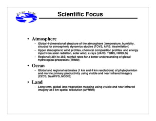
- 1. GS FC DAA C Scientific Focus • Atmosphere – Global 4-dimensional structure of the atmosphere (temperature, humidity, clouds) for atmospheric dynamics studies (TOVS, AIRS, Assimilation) – Upper atmospheric wind profiles, chemical composition profiles and energy input from solar radiation, solar wind, x-rays (UARS, TOMS, HIRDLS) – Regional (35N to 35S) rainfall rates for a better understanding of global hydrological processes (TRMM) • Ocean – Global and regional estimates (1 km and 4 km resolutions) of phytoplankton and marine primary productivity using visible and near infrared imagery (CZCS, SeaWiFS, MODIS) • Land – Long term, global land vegetation mapping using visible and near infrared imagery at 8 km spatial resolution (AVHRR)
- 2. GS FC DAA C HDF / HDF-EOS Data Sets HDF HDF-EOS TOMS UARS (ma ybe ) S EAWIFS TRMM (1997) CZCS MODIS (1998, 2000) TOVS DAS (1998) AVHRR AIRS /AMS U (2000) HIRDLS (2002) MLS (2002)
- 3. GS FC DAA C Current HDF Tools • Visualization / Analysis – Freeware (Collage for HDF, EosView for HDF-EOS) – Data set specific packages, e.g., VISTAS (TOVS), VisuAnalyze (TOMS) – Web based data set browsers – Commercial packages, e.g., IDL, SpyGlass • Utilities – Annotation, metadata extraction – Continental subsetting – HDF-to-binary conversion – Interactive geographic subsetting tool (FORTRAN and C)
- 4. GS FC DAA C Additional HDF Tools • Web or GUI based tool to allow user to specify file characteristics for the automatic creation of HDF file • Browse-o-rama type tools that shield user from HDF-specific terminology • Subsetting tools allowing user to more easily select geographic subregions and/or parameters • Translators to allow users to easily convert from HDF to their working format • Utilize information on fill values and scaling (gain and offset) when displaying HDF data • Include capability to change projections when displaying HDF data