1. i
Evaluation of Bear Rocks Preserve
Grant and Tucker Counties, West Virginia
For its Merit in Meeting National Significance Criteria as a National Natural Landmark in
Representing Plateaus as an Example of Plains, Plateaus, and Mesas in the
Appalachian Plateaus Physiographic Province
Prepared by:
Todd R. Lookingbill1, Natalie E. Somerville1, Carly D. Sibilia1,
David E. Kitchen1, and Katharina A.M. Engelhardt2
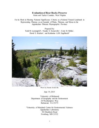
Photo by Natalie Somerville
June 19, 2015
1University of Richmond
Department of Geography and the Environment
28 Westhampton Way
Richmond, VA 23173
2University of Maryland Center for Environmental Sciences
Appalachian Laboratory
301 Braddock Road
Frostburg, MD 21532
2. ii
Table of Contents
Executive Summary........................................................................................................................ 1
Introduction..................................................................................................................................... 2
Source of Site Proposal ............................................................................................................... 2
Evaluators .................................................................................................................................... 2
Scope of Evaluation..................................................................................................................... 2
Characterization of the Primary Natural Feature ............................................................................ 3
Description .................................................................................................................................. 3
Distribution and Context ............................................................................................................. 4
Regional Variation....................................................................................................................... 4
Significance ................................................................................................................................. 5
Bear Rocks Preserve Site Description ............................................................................................ 6
Primary Natural Feature .............................................................................................................. 6
Secondary Natural Features......................................................................................................... 7
Natural History Themes Represented.......................................................................................... 9
Physical Setting ........................................................................................................................... 9
Location and Access.................................................................................................................. 10
Ownership.................................................................................................................................. 10
Land Use and Condition............................................................................................................ 10
Historic Land Use.................................................................................................................. 10
Current Land Use and Present Condition............................................................................. 11
Sensitive or Hazardous Resources............................................................................................. 12
Comparative Assessment .............................................................................................................. 13
Regional Site Inventory............................................................................................................. 13
Site Descriptions........................................................................................................................ 14
Highest Quality Sites ............................................................................................................. 14
Other Sites ............................................................................................................................. 21
Comparative Analysis and Discussion ...................................................................................... 22
Evaluation Recommendations....................................................................................................... 28
Proposed Landmark Boundary.................................................................................................. 28
Literature Cited ............................................................................................................................. 29
Appendix A: Bear Rocks Preserve Species List ........................................................................... 41
Appendix B: Representative Site Photographs ............................................................................. 50
Appendix C: Photographs for Comparative Sites ......................................................................... 68
Special thanks to:
Jared Goldbach Ehmer (University of Richmond ’17), for his assistance with the maps and
figures for this report. Megan Wing (University of Richmond ’1able of7) and Sophie Holmes
(University of Richmond ’17), for their assistance with and contribution to the preliminary
research of Bear Rocks and comparative sites, and for helping to make this report possible.
3. 1
Executive Summary
The National Natural Landmark (NNL) Program encourages the preservation of the Nation’s natural
heritage. To qualify for NNL designation, a site must be one of the best examples of a geological
and/or biological feature within a biophysiographic province.
The Bear Rocks Preserve in Grant County and Tucker County, West Virginia, is an excellent example
of a plateau, and illustrative of the diverse Appalachian Plateaus Biophysiographic Province of the
United States. It is an outstanding example of the NNL geologic theme Plains, Plateaus, and Mesas.
The Bear Rocks Preserve is owned and managed by The Nature Conservancy (TNC). The
Conservancy has consented to allow the site to be evaluated as a potential NNL (pNNL). This
evaluation considers whether the resources at Bear Rocks Preserve are intact, nationally significant,
and deserving of NNL designation. It includes a general characterization of plateaus, a site
description of Bear Rocks Preserve pNNL, a comparative assessment of similar sites, a final
recommendation for designation, and a map of the recommended boundary.
The flat-lying landforms at Bear Rocks are the result of uplift and continental collision and erosion
by ice, rain, wind, and water. Evidence of crustal movement and the aftermath of continental
collision can be seen within the Preserve and the adjacent Valley and Ridge Province. The proposed
site illustrates better than any other the processes that follow continental collision when mountain
landforms are transformed into plateau landscapes by million years of uplift and erosion.
Owing to high elevations, cold temperatures, wind, and shallow soil, the plateau ecosystem supports
a rich boreal ecological community that is dominated by red spruce and heath shrub at higher
elevations and by bogs at lower elevations The stunted spruce trees, exposed rock outcrops, bog and
heath shrubs are habitat to more than 190 species of plants. Many of these species are specially
adapted to shallow soil, high elevations, and harsh conditions. A terrestrial succession with a spruce
forest climax is visible in all stages of development. This interplay of geology and ecology
contributes significantly to the natural history of the region.
The Bear Rocks Preserve is thus of great scientific, conservational, and educational interest because
of its spectacular geological history and its rare and diverse flora. The biggest threats to the system
are an uncontrolled increase in the number of visitors and the long-term impact of fire suppression;
however, the biota is sturdy and able to withstand substantial environmental pressure fromvisitors.
A comparative study shows that the Pocono Front-Delaware Water Gap in the Southern New York
section of the Appalachian Plateaus region shares many significance criteria with Bear Rocks, but
potentially destructive recreational land use practices lessen its significance. The greater elevation,
illustrative geology, rare ecosystem, and higher escarpment with stunning overlooks of the Bear
Rocks Preserve pNNL better illustrate the characteristics of a plateau in this region.
It is our recommendation that Bear Rocks Preserve pNNL meets the national significance criteria
required for the NNL Program. After considerable research, discourse with experts, and three site
visits to Bear Rocks, we have come to the conclusion that Bear Rocks Preserve pNNL is a prime
candidate site to be designated as a NNL. We include a map of the proposed landmark boundary,
which delineates a total of 477 acres (193 ha).
4. 2
Introduction
Source of Site Proposal
The Bear Rocks Preserve was originally recommended as a potential National Natural Landmark
(pNNL) in the Potential National Natural Landmarks of the Appalachian Plateaus Natural
Region Report (Baer et al. 1982; pp. 231-235) commissioned by the National Park Service (NPS).
The Preserve is primarily representative of the Plains, Plateaus, and Mesas (Theme 1) Plateaus
(Sub-theme 1b) natural history theme under the Landforms of the Present grouping (Group I).
The plateau found at Bear Rocks is the product of a mountain-building continental collision and
displays the results of millions of years of erosion. Uplift from tectonic activity, along with
eroding forces of wind, precipitation, ice, and streams, left a relatively flat landform that is
highly dissected today. The high elevation and cold climate of Bear Rocks result in an ecological
community dominated by cold-resistant boreal species such as red spruce and heath shrubs. The
site has not previously been evaluated for NNL status. It received priority for evaluation because
the site represents themes that are currently underrepresented within the Appalachian Plateaus
Natural Region as outlined in “Natural History in the National Park System and on the National
Registry of Natural Landmarks” (National Park Service 1990).
Evaluators
Dr. Todd R. Lookingbill, Associate Professor, Department of Geography and the Environment,
University of Richmond. Dr. Lookingbill is a landscape ecologist with research focusing on the
spatial patterning of the abiotic environment and the processes that affect species distributions
within natural and managed landscapes.
Dr. Katharina A. M. Engelhardt, Research Associate Professor, University of Maryland Center
for Environmental Science. Dr. Engelhardt studies the maintenance of biodiversity and its effects
on ecosystem functioning. Her current research focuses specifically on the feedback between
geomorphology and biodiversity to predict the effects of climate change on ecosystems.
Dr. David E. Kitchen, Associate Dean and Associate Professor, School of Professional and
Continuing Studies. Dr. Kitchen is an earth scientist with a special interest in the impact of
climate change and the origins and impacts of natural disasters. He is currently working on a new
textbook on natural disaster for Oxford University Press.
Scope of Evaluation
The study area used in this evaluation was the Appalachian Plateaus region of the Mid-Atlantic
United States (Figure 1). The sites selected for the comparative assessment lie within a similar
climatic zone as Bear Rocks with an emphasis on sites in the Allegheny Mountains section of the
Appalachian Plateaus province, particularly those sites lying on the Allegheny Front, the
structural front separating the Appalachian Plateaus and the Valley and Ridge provinces (Figure
2).
The evaluation of Bear Rocks is based on scientific literature and conversations with scientific
experts. Three site visits were conducted on March 21, 2015, May 22, 2015 and June 4-5, 2015.
Experts conferred with during the course of this evaluation include: Mike Powell (Land
Conservation Practitioner, West Virginia Chapter of The Nature Conservancy), Jim Vanderhorst
5. 3
(Vegetation Ecologist, West Virginia Division of Natural Resources), Troy Waskey (District
Ranger on the Cheat-Potomac District), Whitney Bailey (Forest Ecologist, United States Forest
Service), Zachary Goodrich (Habitat Management Coordinator, Northern Pennsylvania Chapter
of The Nature Conservancy), Adele Wellmen (Lead Naturalist at Allegany State Park), Gary M.
Fleeger (Geologist, Pennsylvania Department of Conservation and Natural Resources), Kara E.
Deutsch (Chief of Resource Management & Science Division, National Park Service), James
McCann (Maryland Department of Natural Resources), and Dan Feller (Maryland Department of
Natural Resources).
Characterizationof the Primary Natural Feature
Description
Plains, plateaus, and mesas are elevated geological landforms characterized by a level or nearly
level surface topography. They are formed by a combination of factors such as the movement of
tectonic plates, volcanic activity, isostatic uplift, and erosion. Of special interest for this report
are plateaus that form where tectonic compression shortens, thickens and uplifts the continental
crust, but other examples occur when a large volume of magma is erupted at the surface, or when
isostatic uplift occurs due to the intrusion of granitic magma into the crust or changes in mantle
temperature.
Tectonic plateaus are landscape features comprised of horizontal to sub-horizontal layers of
moderately to weakly deformed and faulted sedimentary rock. Significant plateaus of this kind
are located in Tibet (Fielding et al. 1994; Yin et al. 1994), central Asia (Windley et al. 2007),
Iran, on the western side of South America (Reynaud et al. 1999), and in southern Africa.
Tectonic plateaus are also an important part of the natural heritage of the United States and occur
at several locations across the country, most notably in the Colorado Plateau (Stewart et al. 1972),
the Ozark Plateau (Rafferty 1988), and the Appalachian Plateaus (Evans 1994).
Each plateau is unique in some respect. All are shaped over time by the erosional impact of wind,
rain, running water, and ice. Some are sustained over time by the ability of strata (often
sandstones or basaltic lavas) to resist erosion, while others persist for millions of years due to
sustained regional faulting or localized isostatic uplift. These competing forces of erosion and
uplift produce a variety of plateau types. Some, such as the Colorado Plateau, are deeply
dissected due to rapid uplift and vertical erosion by rivers or glaciers. Others, such as the
Appalachian Plateaus, are less deeply dissected because the combined action of vertical erosion
and mass wasting have degraded the entire surface of the plateau more evenly over time.
The tectonic plateaus considered in this study are relatively flat areas of Earth’s surface that are
elevated above the surrounding land, and variably dissected by erosion (National Park Service
1990). They form where tectonic activity produces regional uplift (Grotzinger and Jordan 2010).
Such plateaus are usually bounded by an escarpment, but can also be bounded by a mountain on
one or more sides. Escarpments can develop due to differential erosion of contrasting lithologies,
or by local changes in structure associated with folding. Steep scarp slopes are very often
associated with faults, and major regional scarp slopes, often called “fronts,” tend to mark the
boundary between major structural provinces.
6. 4
Distribution and Context
The Appalachian Plateaus form an elevated province within the Appalachian Highlands in the
eastern United States and consist of sub-horizontal to moderately folded and faulted strata
(Fenneman 1928) that slope gently to the north west and merge with the central plains. Their
eastern boundary is marked by a rapid transition across an escarpment from the less intensely
folded and faulted rocks of the plateaus region to the west to the highly imbricated, faulted and
folded rocks of the Valley and Ridge province. The boundary between these physiographic
provinces occurs across a major crustal fault zone.
The plateaus formed during the Allegheny orogeny circa 225 million years ago following a
continental collision between the current-day continents of North/South America and
Europe/Africa (Rentch n.d.). The Plateaus province stretches from New York to Alabama,
covering parts of the states of New York, Pennsylvania, Ohio, Maryland, West Virginia,
Kentucky, Tennessee, Alabama, and Georgia. The geologic features of a plateau are best seen on
the structural front to the east of this province, where a steep elevation change exists between the
Appalachian Plateaus and Valley and Ridge geological provinces.
Regional Variation
The Appalachian Plateaus province of the eastern United States is divided into seven separate
sections: Mohawk, Southern New York, Catskill, Allegheny Mountains, Kanawha, Cumberland
Mountain, and Cumberland Plateau (Figure 1). The Mohawk section is characterized by a strike
valley developed on rocks of lower Paleozoic age and bounded to the south by the Devonian
Helderberg-Onondaga escarpment. The Southern New York section was glaciated during the last
glaciation period, creating the Finger Lakes and an excellent “through-valley” network due to
glacial and meltwater erosion. The Catskill section has the highest overall topography in the
Plateaus province as well as a significant escarpment on its eastern border, where resistant
Devonian rocks stand as much as 3,000 feet above the Hudson Valley. The Allegheny Mountains
section has a distinct southeastern boundary – the Allegheny Front – resulting in the section’s
characteristic escarpments and vista over the Valley and Ridge province. The Kanawha section
has a distinct northern boundary – the southern limit of glaciation (Figure 3) – and contains a
spectacular gorge, the New River Gorge, with as much as a 2,000 foot elevation difference
between the New River and the plateau surface. The Cumberland Mountain section has a distinct
boundary along faults defining a thrust block 125 miles long by 25 miles wide; this section also
contains the Cumberland Gap, the largest wind gap in the province. The Cumberland Plateau
section is characterized by numerous escarpments, some of which have been sculpted to create
natural bridges and arches (Fenneman 1928). Most of the land of the Plateaus province is higher
in elevation than the surrounding land and is separated from outside areas by an outward-facing
escarpment; the primary or most significant escarpment of the Plateaus province lies on the east
side (Fenneman 1928).
Elevation of the plateau varies along the Plateaus province, rising to greater than 4,000 feet
above sea level in the highest sections and falling as low as 500 feet above sea level at the
southernmost end (Fenneman 1928; Figure 3). Only the Northern part of the Plateaus was
glaciated during the Pleistocene Ice Age (Figure 3). Land that was affected by ice is
characterized by shallow soils, the presence of depositional moraines, and evidence of forceful
erosion by glaciers. In contrast, the plateaus to the south that were not affected by glaciation have
7. 5
greater soil depth with less intense surface erosion, although periglacial features and thin soils
may still occur at elevation. This variation in elevation and glaciation has resulted in
corresponding ecological differences within the Plateaus province. Perhaps the most significant
regional difference in vegetation is seen through the presence and absence of boreal forest. The
boreal forest biome reaches its southernmost limit near the Bear Rocks Preserve, illustrating a
major difference between the Plateaus region to the north of Bear Rocks (containing boreal forest)
and to the south of Bear Rocks (not containing boreal forest).
We focused our research and site analysis on areas of land located within the Allegheny
Mountains section of the Appalachian Plateaus province. Although the entirety of the Plateaus
province demonstrates aspects of plateau geology and its associated ecology, the Allegheny
Mountains section has the highest consistent elevation of any of the sections, as well as the most
distinct structural front and escarpment. The Allegheny Front, the eastern boundary of the
Allegheny Mountains, is associated with the eastern Continental Divide. We believe the
inclusion of that structural front is important for the highest quality sites, as features such as high
elevation and flat surfaces are clearly observable at the edge of the plateau.
Significance
The Appalachian Plateaus province is a distinctive and significant geological and biological
feature of the eastern United States. The geological history of the plateau demonstrates the
interrelated processes of sedimentary basin development, continental collision, uplift, and
erosion, dating back to the Grenville Orogeny circa 1250-980 million years ago and largely
complete by the end of the Allegheny Orogeny 325 million to 260 million years ago. Over this
long period of geological time, shallow marine and continental sediments that were originally
deposited on a continental margin, were progressively compressed, folded, and faulted, and then
eroded, to form the high plateau seen today. The exposed fluvial sandstones of Carboniferous
age that cap the plateau have resisted erosion following uplift of the region. Their high elevation
during the Pleistocene glacial period created an Arctic climate that is still reflected in the
landscape and biology of the area today. Although thought to be biologically depauperate due to
the harsh wind and temperature conditions, the plateau supports a diverse species assemblage
that is an important component of the nation’s natural history. The topographic front of the
plateau provides an opportunity to showcase the geological balance between erosion and uplift
over millions of years, and the deep escarpment presents a unique geological vista over the
Valley and Ridge Province to the Blue Ridge and Piedmont beyond.
8. 6
BearRocks Preserve Site Description
The Bear Rocks Preserve has been proposed for this evaluation as one of the best examples of
mountain plateaus in the eastern United States. Bear Rocks was explored and surveyed in 1742
by Peter Jefferson (father of former U.S. President Thomas Jefferson) and Thomas Lewis as part
of the Fairfax expedition, the first white exploration on the Allegheny Mountains. The Fairfax
expedition described the area of land containing the Preserve as open and clear of trees (Lewis
1925; Strother 1872; Burkhart 2011). Described in a report for the National Park Service as “one
of the most unique areas in the United States…unequalled for scenic beauty and ecological
significance” (Baer et al. 1982; p 232), the Bear Rocks Preserve demonstrates outstanding
examples of plateau geology and cold-climate ecological communities. The Preserve is
significant as a range extension of northern plants, animals, and biotic communities. Bear Rocks
Preserve (39°04’23” N, 79°17’53” W) is located between the city of Petersburg in Grant County
and the town of Davis in Tucker County in the northeastern part of West Virginia (Figure 4). The
477 acres of the Preserve are bounded to the southeast by the Allegheny Structural Front, to the
south by the Fairfax Survey Line and the Dolly Sods Wilderness Area of the Monongahela
National Forest, and to the west by the western limit of the Chestnut Ridge anticline and the
Canaan Valley National Wildlife Refuge. The landscape of the tract consists of dissected
sandstone and wind-swept forests and heathlands. The following sections describe the
environments and ecosystems found in the Bear Rocks Preserve in detail.
Primary Natural Feature
Bear Rocks Preserve is located on the Allegheny Front at the boundary between the Appalachian
Plateaus and Valley and Ridge Provinces of eastern West Virginia (Figure 1). The Preserve is a
periglacial landform and is part of the unglaciated plateau of the Allegheny Mountains section of
the Appalachian Plateaus province. Bear Rocks Preserve is representative of the impact of
continental movement and the collision of plates throughout the natural history of Earth. Cycles
of uplift and erosion during continental collision created a plateau characterized by open folds
and low angle thrust faults (Baer et al. 1982). Over millions of years, erosion has leveled these
folds to form the sandstone-capped plateaus of the Appalachian Plateaus province of today (Baer
et al. 1982). The Allegheny Structural Front is most likely marked at this location by a major
fault at depth and Bear Rocks lies at the edge, on an erosional remnant of the Stony River
syncline, a result of the mountain-building collision that occurred about 225 million years ago
(Rentch n.d.).
Along a relatively flat surface behind the escarpment, sandstones and conglomerates belonging
to the basal Pottsville Group crop out at the surface. These rocks are embedded with white quartz
pebbles, are tightly cemented with silica, and bear the fossilized imprints of vegetation. These
rocks, that are both hard and resistant to erosion, produce acidic soils and are visible throughout
the Bear Rocks Preserve (Gibson 1970). The underlying geology consists of strata typical of
Upper Carboniferous formations including clay, sandstone, and coal (Englund et al. 1980; Baer
et al. 1982).
The elevation and the degree of dissection of the plateau are greater in the Bear Rocks area than
in areas lying to the west (Baer et al. 1982). At just over 4,000 feet above sea level, the Bear
Rocks Preserve provides an unobstructed view of the Valley and Ridge physiographic province
9. 7
and the Blue Ridge Mountains to the east. The long parallel northeast-southwest trending valleys
and ridges that characterize the Valley and Ridge province are clearly visible and visitors to Bear
Rocks can stand on the edge of the Allegheny Front and behold one of the great geological
wonders of the world.
Secondary Natural Features
The Bear Rocks Preserve provides an outstanding example of high-elevation, cold-weather
ecology, seen most significantly in the shrub community and the extension of the boreal forest
biome usually found farther north. Three plant communities within the Bear Rocks Preserve have
G2 global conservation status ranking, designated by NatureServe, meaning they have a very
restricted range and very few populations throughout the world. The Natural Heritage Program
of West Virginia also assigns state ranks of S1, S2, or S3 to ecological communities. The three
G2-ranked communities of Bear Rocks are listed by their global and common names in Table 1
below; the table also includes the state ranks of the communities. The prevailing cold, wet
climate of the Preserve determines the ecological makeup of the land. Many of the species of
Bear Rocks today are traceable to the Pleistocene glaciation – although glaciers never reached
the Preserve, the cold associated with the period of glaciation had a long-lasting impact on the
ecological conditions (Allard and Leonard 1952; Gibson 1970). The Allegheny Front is one of
the windiest spots in the eastern United States. The soil depth on the Preserve is thus not too
deep or rich; much of the tract is covered by rock outcrop (Figure 5). Harsh conditions exist on
the front and limit the range of vegetation: strong, westerly winds are essentially constant, rime
frost precipitates onto plants from low winter clouds, and heavy snowfall can weigh down trees
and shrubs (Gibson 1970). The plant community of Bear Rocks demonstrates the strength of
ecological adaptation to even the most inhospitable geological and weather conditions (Baer et al.
1982). Spruce trees survive the wind by growing branches only on their eastern sides;
accumulated snow, while causing damage to taller plants, acts as a protective, insulating blanket
over lower vegetation (Gibson 1970).
Table 1. Global and state rankings of three ecological communities found in Bear Rocks.
Global Name Common Name G Rank S Rank
Picea rubens / Kalmia latifolia – Menziesia
pilosa Woodland
High Allegheny Red
Spruce Woodland
G2 S1
Vaccinium oxycoccos – (Vaccinium
macrocarpon) / Rhynchospora alba – Drosera
rotundifolia / Sphagnum spp. Dwarf-shrubland
Cranberry – Beaksedge
Peatland
G2 S1
Kalmia latifolia – Gaylussacia baccata –
Vaccinium (angustifolium, pallidum) –
Menziesia pilosa Shrubland
Central Appalachian
Heath Barrens
G2 S2
A general terrestrial succession exists in ecosystems of the central Appalachians above 3,000 feet
elevation, which is visible in the Bear Rocks Preserve. The succession begins with bracken
brakes and sods, then moves on to low shrub mat, tall shrub bush, colonial and scrub forests,
northern hardwoods forest, northern hardwoods-hemlock-spruce-white pine forest, and ends with
a climax of spruce forest (Baer et al. 1982). Several plant species at each stage of succession can
be found within the Preserve. Small vegetative species, including bracken fern (Pteridium
aquilinium), eastern hay-scented fern (Dennstaedtia punctilobula), wrinkleleaf goldenrod
10. 8
(Solidago rugosa), bog goldenrod (Solidago uliginosa), whorled wood aster (Oclemena
acuminata), purple-stem aster (Symphyotrichum puniceum), poverty rush (Juncus tenuis),
narrowleaf gentian (Gentiana linearis), violet (Viola), flattened oatgrass (Danthonia compressa),
bristly dewberry (Rubus hispidus), strawberry-raspberry (Rubus illecebrosus), as well as
seventeen varieties of mosses and several lichen species, exist in the Preserve as species of the
lowest successional stage of bracken brakes and sods. Plants of Bear Rocks within the low shrub
mat successional stage include velvetleaf blueberry (Vaccinium myrtilloides), northern lowbush
blueberry (Vaccinium angustifolium), black huckleberry (Gaylussacia baccata), mountain laurel
(Kalmia latifolia), black chokeberry (Photinia melanocarpa), red chokeberry (Photinia
pyrifolia), wintergreen or teaberry (Gaultheria procumbens), trailing arbutus (Epigaea repens),
and blackberry (Rubus ssp.). Tall shrub bush species, including Allegheny serviceberry
(Amelanchier laevis), common winterberry (Ilex verticillata), mapleleaf viburnum (Viburnum
acerifolium), northern wild raisin (Viburnum nudum), and black elderberry (Sambucus nigra)
grow among the sandstone rocks in the Preserve. Tree species within the colonial and scrub
forests successional stage, such as quaking aspen (Populus tremuloides), yellow birch (Betula
alleghaniensis), mountain holly (Ilex montana), pin cherry (Prunus pensylvanica), red maple
(Acer rubrum), and pitch pine (Pinus rigida), grow in the Bear Rocks tract. Red spruce (Picea
rubens), the most well-known tree species in the Preserve for its characteristic flagged
appearance, fits into the later successional stages of spruce forests. A complete list of all plants
recorded at the site is attached as an appendix to this report (Appendix A).
The cold-resistant plants of the Preserve’s ecological community form a part of the global boreal
forest biome, a biome with its southernmost extensions in the higher mountain elevations of the
Alleghenies (Gibson 1970; Baer et al. 1982; Rentch n.d.). Boreal forest ecosystems comprise the
largest land-based biome on the earth and are critical for the global carbon cycle in their role as
carbon sinks (Schulze et al. 1999; Taggart and Cross 2009; Potapov, Turubanova, and Hansen
2011). Boreal species are usually linked to subarctic and cold climates, favoring conditions with
high elevations, steep slopes, and moderate drainage (Messaoud et al. 2007). The plateau of Bear
Rocks exemplifies these favorable conditions and displays a cold-climate ecosystem. Only tough,
hardy, cold-resistant boreal species can withstand harsh winters, such as those seen on the
Allegheny Front. Global climate change has the potential to severely affect boreal forests and
cause a northward-trending migration as boreal species search for cool, suitable temperatures
(Kojima 1994; Taggart and Cross 2009; Scheffer et al. 2012). The boreal forest species of the
Bear Rocks area are a representative remnant of one of the finest climax spruce forests in the
eastern United States, a forest that once covered much of the Allegheny Mountains (Allard and
Leonard 1952).
The ecological community on the Bear Rocks Preserve includes a portion of the largest expanse
of heathland in the Central Appalachian Plateaus region. Plants of this heath barren include
shrubs such as minniebush (Menziesia pilosa) and the previously mentioned mountain laurel,
black huckleberry, and northern lowbush blueberry. Bogs are another significant ecological
feature on the Preserve; there are several bogs located in the area on the Allegheny Front (Gibson
1970). Bear Rocks Preserve contains and buffers the upper portions of the Bear Rocks Bog, a
bog supporting northern stitchwort (Stellaria borealis) in its southernmost known colony (Powell
pers. comm.). The bogs of Bear Rocks contain both large cranberry (Vaccinium macrocarpon)
and small cranberry (Vaccinium oxycoccos), drawing visitors in the fall season for berry picking.
11. 9
The ecology of the Preserve can be generally categorized as consisting of deciduous and
evergreen forest (Figure 6); however, much of this land cover is made up of the heath shrub
species. Other ecological features of the Bear Rocks Preserve include subalpine grass balds and a
wide array of lichen species. Records of varied fauna species within the Preserve are less
complete. Mammals on the Preserve include the Allegheny woodrat (Neotoma magister), a
species that has been in decline in the northern ranges of its habitat and is state-listed as
threatened, endangered, or sensitive in every state where they are found. Bear Rocks is a major
flyway for migratory raptors, which take advantage of the air currents and thermals found along
the Allegheny Front due to elevation changes. One species among these is the northern goshawk
(Accipiter gentilis). Several insect species have their habitats within Bear Rocks, including
black-tipped darner (Aeshna tuberculifera), pink-edged sulphur (Colias interior), Allegheny
mound ant (Formica exsectoides), and bog copper (Lycaena epixanthe).
Natural History Themes Represented
Bear Rocks Preserve is representative of the Plateau sub-theme (1b) under the Plains, Plateaus,
and Mesas natural history theme (1) of Group I: Landforms of the Present as identified by the
NNL program. The primary feature of the Preserve, the flat outcropping of Pottsville sandstone
forming a plateau just on the Allegheny Structural Front, splendidly fits the description of the
Plateau sub-theme (1b).
Of secondary importance are the biological and ecological features of the Preserve. The
dominant ecosystem found within Bear Rocks represents the Appalachian Highland sub-theme
(21b) under the Boreal Forest natural history theme (21) of Group III: Land Ecosystems. The
plant species within the Preserve are cold-hardy, boreal species typical of a northern climate. The
shrub community in the Preserve is of high-quality, featuring a variety of stubborn, tenacious
shrub and heath species throughout the tract. In addition, the bogs within the Bear Rocks area fit
into the Bogs sub-theme (32o) under the Lakes, Ponds, and Wetlands theme (32) within Group
IV: Aquatic Ecosystems. The geology of the Preserve – the underlying rock and the exposed
outcroppings – is made up of Pottsville sandstone, a rock of the Pennsylvanian age thus
representing the Pennsylvanian Period sub-theme (16b) within Group II: Geologic History.
Physical Setting
Bear Rocks Preserve is located on the border of the Appalachian Plateaus and Valley and Ridge
provinces. The Preserve is fully contained within the Allegheny Mountains section of the
Appalachian Plateaus province. The elevation of the Preserve exceeds 4,000 feet above sea level,
a height contributing to a cool climate similar to alpine or tundra. Air temperatures can go up
into the 80s (degrees Fahrenheit), but can drop well below 0° Fahrenheit in winter; there is a
possibility of frost during any night of the year (Gibson 1970). Winters are prolonged in this area,
with cold, snowy conditions lasting later than in the rest of the state. The Bear Rocks Preserve,
located on an elevated plateau, receives a significant amount of precipitation due to orographic
lift as air masses move from west to east. Dense fog is also common (Baer et al. 1982). Average
annual total rainfall is 52 inches (132 cm); snowfall may reach 150 inches (381 cm) on Bear
Rocks and the surrounding ridge (Gibson 1970; Powell pers. comm.). In addition to the high
elevation and snowfall, the Allegheny Front is characterized by its strong, prevailing westerly
winds contributing to the harsh conditions of the Bear Rocks Preserve.
12. 10
Location and Access
Bear Rocks Preserve is located within a 477-acre tract of land on the eastern edge of the
Allegheny Mountains, bounded on the south by the Dolly Sods Wilderness and on the east by the
Allegheny Front. The delineated boundaries for the Bear Rocks Preserve pNNL are identical to
the boundaries of the Bear Rocks Preserve and include all 477 acres officially managed by The
Nature Conservancy. The address of the Bear Rocks Preserve is Bear Rocks, Union, WV 26260.
To access the Preserve from Petersburg, take WV 55 west to Jordan Run Road/Rt. 28/7 (a right
turn). Take Jordan Run Road 1 mile then turn left onto Forest Service Road 19 and follow it for
six miles to the top of the Allegheny Front. At the top of the mountain, turn right onto Forest
Service Road 75. Continue on FS Road 75 for about eight miles to the Bear Rocks parking lot
(where the road turns sharply to descend the mountain). The Bear Rocks Preserve is a very short
walk north of the parking lot. There is one official entrance to the Preserve, delineated by an
informational sign and clearly accessible by a wider path from the parking lot (Figure 7). The
Bear Rocks Preserve is open to the public for hiking, nature study, and noncommercial berry
picking; several informal sandstone and dirt social trails weave throughout the Preserve, while an
extensive trail system exists within adjacent national forest lands. Winter weather conditions
present potential barriers to visiting the Preserve, as the FS Roads are not plowed in winter. The
United States Forest Service (USFS) controls the two access points – either end of FS Road 75,
both of which have gates – and closes the gates during winter months. Reliable information on
snow conditions and accessibility can be obtained by calling the Petersburg Ranger Station in
West Virginia (304-257-4488). Bear Rocks Preserve is completely within the 1:24,000 scale
topographic map quadrangle “Blackbird Knob WV” (Figure 4).
Ownership
The 477 acres of the Bear Rocks Preserve is owned and managed by The Nature Conservancy
(Figure 8). The Nature Conservancy acquired this area of land, including all mineral rights to the
tract, on 17 February 2000 as a gift from Virginia Electric and Power Company (Dominion); the
official dedication of the Preserve was 14 June 2000. The Nature Conservancy can carry out
whatever management strategies and conservation efforts they wish on the Preserve – they may
not, however, assign, transfer, lease, or convey any part or any interest in the Preserve without
prior written approval of Dominion Power (Powell pers. comm.) The proposed landmark
boundary is the Preserve boundary.
Land Use and Condition
Historic Land Use
The conditions of Bear Rocks were documented and described as being open and unforested,
even before the industrial logging period, by the 1872 writings of David Hunter Strother (better
known by his pen-name Porte Crayon) and by the 1746 diary of Thomas Lewis, a member of the
Fairfax survey expedition of the same year (Burkhart 2011). These two sources describe the area
as being clear of timber, covered with large, flat rocks, and containing an occasional stack of
boulders and straggling firs (Lewis 1925; Strother 1872).
At the time of early exploration and settlement, dense red spruce forests and associated wetlands
covered the area adjacent to Bear Rocks (what is now the Dolly Sods Wilderness). Between 1880
and 1920, logging took place on this forested land, resulting in a complete clear and burn of the
13. 11
Dolly Sods area by the 1920s; the area has been slowly recovering, however, and spruce forests
now cover over half of the Dolly Sods Wilderness (Clarkson 1964; Baer et al. 1982; Burkhart
2011). In contrast to the cleared and logged Dolly Sods land, the area that is now Bear Rocks did
not have extensive forests to be cleared, and thus was not logged. People did take advantage of
the heath barrens, bogs, and grass balds of the Bear Rocks area, though, for berry picking and as
livestock grazing lands (Gibson 1970).
The tract of land that is now Bear Rocks Preserve had been part of large corporate timber
holdings during the first half of the twentieth century. United States Leather (or Union Tanning)
held it from 1902-1920; Babcock Lumber Company owned it from 1920-1925, cutting the virgin
spruce timber on the land; Central Tie and Lumber held the tract from 1925-1953, though the last
logging on Bear Rocks occurred during 1925. Individuals then owned the area of land for
investment purposes: Arthur Goldizen owned it from 1953-1961 and Henry and George Moomau
held it from 1961-1962. During World War II, the United States army used the Dolly Sods area
as an artillery training area; informational signs on USFS Wilderness and TNC Preserve lands
warn visitors to keep an eye out for unexploded ordnance or shell fragments that they may
encounter. Bear Rocks Preserve was not included in the official artillery training area, but shells
may have ended up within the area of the Preserve. Virginia Power acquired the land in 1962 for
coal mining – however, they never mined coal on the tract. Virginia Power completed an
unexploded ordnance assessment prior to giving the tract to TNC (Powell pers. comm.). In
February of 2000, Virginia Power gifted the Bear Rocks tract to The Nature Conservancy.
Current Land Use and Present Condition
The Bear Rocks Preserve is managed by The Nature Conservancy, with the purpose of protecting
and managing the natural communities with an emphasis on maintaining resources of high
ecological value such as high-elevation forest. Bear Rocks Preserve is in excellent condition and
does not require much active management on the part of The Nature Conservancy. Part of the
management of Bear Rocks has included red spruce tree planting (primarily in the bog area, not
on the front) with the goal of connecting to a red spruce stand on adjacent USFS property
(Burkhart 2011; The Nature Conservancy 2015). Another recent management project entailed
placing coconut fiber logs and small rock walls in stream channels to reduce erosion. The
Conservancy also filled in some stream channels by moving rocks, soil, and clumps of shrubs
into channels to try to mimic the natural look of the land while lessening the velocity of future
streams (Powell pers. comm.).
The Nature Conservancy maintains good relations with adjacent landowners, as it has the biggest
strategic ecological impact by working with neighbors such as the United States Forest Service
(Powell pers. comm.). The USFS and TNC have a good working relationship: while the two
groups do not collaborate on their individual management plans for protected areas, they share
management resources including summer field crews. The Nature Conservancy has a long-
standing partnership with Dominion Power – the landowner to the north of the Preserve –
exemplified by the gifting of Bear Rocks by Dominion to the Conservancy (Powell pers. comm.).
Even though timber and energy companies (primarily Western Pocahontas and Dominion Power)
own the land around Bear Rocks and Dolly Sods, these companies cannot initiate any action to
take back land owned by TNC or the USFS. Unless The Nature Conservancy willingly lets go of
14. 12
ownership of Bear Rocks, energy and timber companies cannot mine coal or install windmills on
the tract.
As The Nature Conservancy owns one hundred percent of mineral rights to the land, there are
not many current threats to the Bear Rocks Preserve. While Bear Rocks is safe from destructive
land use practices within the 477 acres of the Preserve, the practices of Dominion Power pose an
indirect threat to the land. Deposition of pollutants on Bear Rocks can be a problem since toxins
from the Power Station are released into the atmosphere and precipitate onto the Preserve.
However, due to the prevailing westerly winds, most of the smoke from the Mount Storm Power
Station (a Dominion Power station five miles north of the Preserve) blows eastward from the
plant into the Valley and Ridge Province. Since the water table of Bear Rocks is very close to the
surface of the land, any soil disturbance or erosion could cause the water to flow up over the
surface. Another potential ecological threat is invasive species such as spotted knapweed
(Centaurea maculosa), a plant that eats both grass balds and three-toothed cinquefoil (Potentilla
tridentata) on the Preserve and surrounding land (Powell pers. comm.).
Bear Rocks Preserve is in excellent present condition. The relatively open and clear Preserve of
today demonstrates the historical open conditions of the area. With the exception of some trees in
the bog area of the Preserve planted by The Nature Conservancy, all the red spruce trees on the
tract north of the Fairfax Line are a result of natural regeneration. There has been very little
human impact in the Preserve, primarily due to the hardy and resistant nature of the ecological
community. The plants are stubborn, cold-resistant, boreal species, and they are thus able to
withstand visitors walking through the site. The Preserve welcomes several thousand visitors
annually. Overnight camping is not permitted on Bear Rocks, but visitors wishing to camp can
drive a few miles south along Forest Service Road 75 to the Red Creek Campground within the
Dolly Sods Wilderness. According to the Conservancy’s most recent management plan, all
hunting seasons are permitted on Bear Rocks, but not explicitly promoted (Powell pers. comm.).
The Nature Conservancy does not allow the use of horses on the Preserve – enforcement of this
policy is difficult, though, as horses are permitted on neighboring USFS land and there are some
trails connecting USFS land to the Preserve. No fires are allowed on the Preserve, either those
started by visitors or by TNC staff members. Popular daytime activities on the Preserve include
nature study, hiking, berry picking, photography, and bird watching. The season for blueberry
picking runs from mid-June through August, while cranberry-picking season does not arrive until
autumn. The fall season provides the most activities, as the tract is part of a major flyway for
raptors migrating in autumn, and due to the bright, red leaves and scenic vistas that attract
visitors to document one of the most frequently photographed sites in the state of West Virginia.
Sensitive or Hazardous Resources
The Bear Rocks Preserve is a small tract of land containing a mix of ecosystems and wide
variety of plant species. The ecosystem of the Preserve is inclusive of three G2-ranked
communities – High Allegheny Red Spruce Woodland, Cranberry-Beaksedge Peatland, and
Central Appalachian Heath Barrens – the first two of which also have a critically imperiled state
rank of S1; there are also exceptional high-elevation cranberry bogs in the Preserve. Species of
concern found within the Preserve include the Allegheny woodrat (Neotoma magister), pink-
edged sulphur butterfly (Colias interior), and bog copper butterfly (Lycaena epixanthe). The
pink-edged sulphur, while not yet federally listed as threatened, exists only in an isolated
15. 13
population in the Central Appalachians – butterflies found in Bear Rocks exist here at the
southernmost extent of their habitat range. Another species of interest found in Bear Rocks is the
northern goshawk (Accipiter gentilis). While the northern goshawk is not rare or endangered, it is
a raptor typically found in colder locales to the north; its presence in Bear Rocks is thus
significant. Although not officially documented at the site, the habitat in Bear Rocks is
conducive to the Cheat Mountain salamander (Plethodon nettingi; on the list of federally
endangered species), snowshoe hare (Lepus americanus), and saw-whet owl (Aegolius acadicus;
both typically found farther north).
Comparative Assessment
Regional Site Inventory
The Allegheny and Appalachian Plateaus encompass a vast area of relatively flat layers of
sedimentary rock. The challenge was therefore to select comparison sites among the many
available that were most representative of a Plateau. The Plateau feature has three characteristics
that we looked for in comparison sites: a) flat sedimentary rock that b) is elevated and therefore
features an escarpment and c) may be dissected through erosion by creeks and rivers. Using GIS,
we used the USGS National Gap Analysis Program Protected Areas Database (v. 1.3) including
sites with Status codes 1 and 2, to generate a map of all protected areas on the Appalachian
Plateaus. Areas with status codes 1 and 2 have permanent protection and a mandated
management plan (USGS GAP 2012). We then determined which of the protected areas bisected
the Allegheny Front or featured an escarpment. Sites recognized as particularly alluring to the
public or specialists due to scenic overlooks, rock outcrops, or high levels of biodiversity were
then considered in the primary stages of deliberation. These sites are listed below in alphabetical
order.
In addition to the GIS approach, we also reviewed all pNNL studies for the Appalachian Plateaus
region that identified Plateau as a natural resource theme. We then included all of those pNNLs
in our comparisons that featured elevated land with an escarpment. Through this comprehensive
selection process, we identified comparison sites that appeared to fulfill the Illustrative Character
criterion (Table 2). Using literature and Internet searches, site visits, and conversations with
natural resource managers, we further narrowed down the list of sites to be included in our
comparative assessment (sites with asterisks) that best illustrate the Plateau feature, including flat
and elevated land dissected with streams, and preferably featuring an escarpment with exposed
rock formations.
Table 2. List of comparative sites and their respective illustrative features.
Site State Flat & Elevated Dissected Escarpment Total
Allegany State Park* NY 2
Black Moshannon* PA 2
Dan’s Mountain* MD 2
Dobbin Slashing WV 2
Mt. Porte Crayon WV 2
Long Pond* PA 2
Pocono Front – DEWA* PA 3
Tug Hill NY 2
16. 14
We then examined the Present Condition of each of the sites to determine which sites would
warrant a full comparison with Bear Rocks Preserve pNNL using all five evaluation criteria
(Illustrative Character, Present Condition, Diversity, Rarity, and Value for Education and
Science).
After careful consideration, Pocono Front-Delaware Water Gap in PA emerged as the only close
competitor to Bear Rocks for NNL status, and is therefore the only site we consider in a full
comparison using all five evaluation criteria. Other sites (Allegany State Park, Black Moshannon
State Park and Forest, Dan’s Mountain, and Long Pond Macrosite) are only considered in a two-
point comparison using the Illustrative Character and Present Condition criteria. The remaining
sites (Dobbin Slashing, Mt. Porte Crayon, and Tug Hill) are all listed as pNNLs in Baer et al.
(1982) and are summarized here, but were excluded from the comparative assessment owing to
their low significance in representing the Plateau theme.
Site Descriptions
Each of the sites detailed in this section contains a section of the Appalachian Plateaus that
illustrates the Plateau natural resource feature. High Quality sites (Table 3) are detailed below
and included in the comparative assessment.
Table 3. Comparison of maximum site elevation and escarpment height between most qualified
locations. Elevation is measured in feet.
Highest Quality Sites
Allegany State Park
Allegany State Park (42.115° N, 78.72° W), owned by the State of New York, received high
priority ranking in the Potential National Natural Landmark of the Appalachian Plateaus Natural
Region, 1982 Geological Report due to characteristics influenced by its location in the
unglaciated Allegheny Plateau section (Baer et al. 1982). Covering nearly 65,000 acres within
Cattaraugus County, NY, Allegany State Park exists within a geologically distinct area known as
the Salamanca Re-entrant, a portion of the Allegheny Plateau never reached by the last
Wisconsin ice sheet (OPRHP 2010). This distinction has influenced soils and surficial geology
topography, as well as the region’s flourishing flora and fauna. Allegany State Park, protected
since 1921 and now often referred to as the “wilderness playground of Western New York,” is
considered as a comparative site to Bear Rocks Preserve pNNL due to its combined natural
features and its relation to glacial and post-glacial drainage change (Baer et al. 1982).
What is now Allegany State Park is an area that alone escaped the advance of the glacier at the
end of the Ice Age that scoured New York, broadening valleys and depositing rocks (Ostertag
Site Name Max. Elevation Max. Escarpment Height
Bear Rocks 4,012 1,762
Dan’s Mountain 2,898 2,188
Allegany State Park 2,425 N/A
Black Moshannon 2,307 1,488
Long Pond Macrosite 1,974 842
DEWA-Pocono Front 1,057 756
17. 15
and Ostertag 2002). Park topography instead consists of rolling hills dissected by streams, which
are intermittent, especially at higher elevations (OPRHP 2010). The rugged hills within the park
rise abruptly to elevations nearing 2,400ft, varying between 800 and 1,000ft above the valleys
(1,400ft) and neighboring plains (1,200ft) (Lobeck 1927). Although the effects of glaciers (in the
form of ice erosion or morainal deposition) did not directly modify the park’s terrain, glacial
meltwater reversed the once northbound flow of the Allegheny River (Baer et al. 1982). This
process resulted in deep stream down cutting, leading to the formation of steep valley sides
superimposed on a relatively level upland terrain. The term “maturely dissected plateau”
therefore briefly defines and describes the Allegany State Park region within the vast
Appalachian Plateaus (Lobeck 1927).
The bedrock of the park consists of horizontal beds of shales, sandstones, and conglomerates,
resulting in relatively stony, course-textured, moderately deep, well-drained soils of moderate to
low fertility (OPRHP 2010). The ruggedness of the landscape is partially attributed to the
presence of sandstone, which characteristically resists weathering. The lowest strata found at the
bottom of the hills belong to the Chemung formation, followed by the Cattaraugus formation
containing the Salamanca conglomerate in its middle portion. Next is the Oswayo formation, and
at the top the Knapp formation and Olean conglomerate member of the Pottsville formation
(Lobeck 1927). Outcrops of these layers can be seen at the base of hills where streams cut
against banks, as well as designated locations such as Thunder Rocks and Bear Caves (OPRHP
2010). Moreover, the weathered, productive soils and undisturbed bedrock combined with the
humidity and high precipitation levels of the area altogether facilitate the growth of the park’s
old growth forests.
The unglaciated recent history, soil types, landforms and climate combine to allow both northern
and central Appalachian plant species to thrive, providing a rich diversity in both the canopy and
the understory (Taylor 1928). Allegany State Park contains the best representation of the
Hemlock-White Pine-Northern Hardwoods Forest Region in the northern section of the
unglaciated Allegheny Plateau, and features climax forest types such as Beech-Birch-Maple and
Oak-Hickory (Bear et al. 1982). Additionally, hundreds of wildflower and low-lying shrub
species can be found within park grounds, resulting in what Lobeck (1927) describes as a
“botanist’s paradise.”
Declared as one of the nation’s top “Amazing Spots” by Reserve America in 2007, Allegany
State Park is known for its idyllic beauty, quiet charm, and wealth of natural life
(PRNewsWire.com). The park is home to a number of rare species, and wildlife is abundant,
including many species of birds, fish, mammals, reptiles and amphibians (OPRHP 2010). With
approximately 1.5 million visitors a year, Allegany State Park is both accessible and
accommodating in its transportation and recreation programs, which include camping, skiing,
fishing, nature studies and more (OPRHP 2010).
Although its even height peaks and ridges separated by v-shaped valleys are highly
representative of a maturely dissected plateau, Allegany State Park fails to fully illustrate the
Plateau theme with a defining escarpment and associated exposed rock outcrops. It is therefore
not included in the full comparative assessment with Bear Rocks Preserve pNNL.
18. 16
Black Moshannon State Park and Forest
Black Moshannon State Park and State Forest (40°53′54″ N, 78°03′23″ W) together cover over
46,000 acres within Centre, Clearfield, and Elk counties in Pennsylvania. The forest, which helps
create the park’s remote and wild feel, envelops the 3,394-acre park, located entirely in Centre
County. Both areas are owned and managed by the Pennsylvania Department of Conservation
and Natural Resources, and together see hundreds of thousands of visitors each year. Both the
park and forest sit upon an unglaciated section of the Allegheny Plateau at an average elevation
of 1,900ft (Bonta 1995). The Allegheny Front crosses through the eastern edge of the state forest,
creating scenic overlooks of the Valley and Ridge Province to the southeast. Such views are
highlighted by lookouts along the Allegheny Trail, as well as the height of the escarpment that
falls an average of 1,300ft.
Declared one of Pennsylvania’s “25 Must-See State Parks” by the PA DCNR Bureau of Parks in
2008, Moshannon State Park and its surrounding forests are considered significant due to their
diverse and specialized vegetation communities. The park’s high elevation and slight basin shape
traps cooler, heavier air, resulting in bogs characterized by Sphagnum moss and freshwater
wetlands. The low temperatures paired with acidic and low nutrient soil conditions facilitate the
growth of seventeen species of orchid and all three carnivorous plants found in Pennsylvania
(Young 2001). Additionally, the Black Moshannon Bog Natural Area is considered by botanists
to be “the best reconstituted bog in the high plateau region,” as it features many plants and
animals, including the leatherleaf (Chamaedaphne calyculata) and the Canada warbler
(Cardellina canadensis), which can be seen here near the southern edge of their range (Bonta
1995). Unlike other wetlands however, the saturated areas at Black Moshannon were not a result
of glacial retreat; instead, sloping bedrock continuously directs water from surrounding hills into
the shallow groundwater table, increasing the soils’ overall moisture levels (Black Moshannon
Recreational Guide 2013).
Three bedrock units have been mapped within park boundaries: the Pennsylvania-age Pottsville
Group, the Mississippian-age Mauch Chunk Formation, and Burgoon Sandstone. As suggested
previously, the bedding is described as “sub horizontal,” typically dipping “15 or less to the
northwest or southeast.” The Pottsville Group is the youngest within the park, occupying
topographic highs including the ridges on either side of the dam, and two less pronounced
hilltops. Due to its position, only the basal unit of the formation has been observed, the upper
units being lost to erosion. Moreover, the unconformity between the Pottsville Group and the
Mauch Chunk Formation is considered representative of “an ancient erosion surface and/or a
period when no rock units were deposited.” The third unit, the Burgoon Sandstone member,
underlies the foundation of the dam, the lakebed, and most of the tributary drainages (Black
Moshannon Resource Management Plan 1993).
The 250 acre Black Moshannon Lake presents just one of the many recreational opportunities
within the wide span of this park and its surrounding forest. Besides swimming, boating, and
fishing, this area provides a catalog of activities including picnicking, mountain biking, and
camping. Seasonal recreation includes ice skating, snowmobiling, cross-country skiing and
hunting, as well as a number of environmental interpretation programs. Moreover, since the area
includes not only bogs and wetlands, but also mature hardwood forests, pine plantations,
Rhododendron thickets, and hemlock groves, many animal species have taken residence within
19. 17
the park. While game species such as deer, wild turkey, grouse, and squirrel are abundant
throughout the park’s forests, those who observe carefully may also find songbirds, bats, bears,
coyotes and more. In fact, due to the high volume of avian species, the National Audubon
Society has designated the park as an Important Bird Area (Black Moshannon Recreational
Guide 2013).
Despite these many options for recreation, the component of Black Moshannon State Park and
Forest that is most illustrative of the Allegheny Plateau is the Allegheny Front Trail. Built in the
late 1990s, this trail encircles Black Moshannon State Park, traversing approximately 40 miles of
the Allegheny Plateau (Cramer 2014). The path leads hikers past beautiful streams and creeks, up
and down challenging and rocky ridges, and across stone bridges and boardwalks throughout the
bogs and swamps. Most importantly, up to 3 miles follow the edge of the Allegheny Front,
featuring 6 identified vistas and some areas of nearly continuous views (Cramer 2014).
The expansive and educational views of the neighboring Valley and Ridge Province, direct
access to the steep escarpment of the plateau, and the unglaciated characteristics demonstrated by
this region, make Black Moshannon lands highly competitive as a potential Appalachian
Plateaus landmark. However, Black Moshannon is not included in the full comparative
assessment with Bear Rocks Preserve pNNL due to its Present Condition. The area was clear cut
about a century ago and thus the forests in Black Moshannon State Park are regrowth stands.
Additionally, the lake of Black Moshannon State Park, although a tourist attraction, is an
artificial lake produced by the damming of Black Moshannon Creek.
Dan’s Mountain
Located in Allegany County, Maryland, Dan’s Mountain includes both Dan’s Mountain State
Park (39°33′28″ N, 78°57′12″ W), as well as the neighboring Dan’s Mountain Wildlife
Management Area (WMA). Both the park and the wildlife management area are owned by the
state and managed by the Maryland Department of Natural Resources. Dan’s Mountain stretches
16mi long, and reaches peaks of around 3,000ft, and the state park covers an area of 482 acres at
a mean elevation of 2,224ft (DNR Owned Lands Acreage 2014). About a mile and a half to the
east of the park, the WMA consists of a 9,504acre tract along the steep ridges of the mountain,
which range 900 to 2,800ft (Dan’s Mountain WMA 2015). Dan’s Mountain represents the
Maryland portion of the Allegheny Front, forming the eastern edge of the Maryland section of
the Allegheny Plateau physiographic region. This particular area of the greater high plateau,
which encompasses all of Garrett and western Allegany County, is described as the elevated
upland between the long parallel crests of Dan’s and Savage Mountain (Bullock-Clark et al.
1900). Although relatively dissected, the area that contains the northeast-southwest ridges of the
two mountain ranges is representative of a plateau in its elevated surface and steep outer
escarpments.
The general upland of the plateau has a strongly rolling surface as a result of steep-sided stream
valleys that cut deeply into what would otherwise be an even-lying surface approximately
2,100ft above sea level (Bullock-Clark et al. 1900). The undulations of the plateau are most
strongly marked along a line about midway between the crests, which owe their prominence to
the upturnings of the resistant Pottsville sandstone (Bullock-Clark et al. 1900). While the inner
boundaries of the mountains gradually fade into the center region, the sudden upward bending of
20. 18
the strata around the edges of the plateau result in mountains with steeper outer-slopes (Bullock
Clark et al. 1900). Borders of the plateau are therefore asymmetrical; the steeper and shorter
slopes fall towards the valleys of the Savage (2,400ft) and Potomac (700ft) Rivers, and the
longer, gentler slopes melt back into the upland (Bullock-Clark et al. 1900).
Streams of the plateau district are all comparatively small with the single exception of the
northern branch of the Potomac. Dan’s Mountain specifically features a large number of small,
intermittent streams that drain down its eastern face, etching the façade and revealing the
bedrock beneath. The growing gullies and ravines expose rocks belonging to the Mauch Chunk
and Greenbrier formations. At about 1,800ft are rounded foothills marking the junction of the
Hampshire and Jennings formations. These formations are the youngest Paleozoic strata in the
county and exhibit almost horizontal bedding, increasing in dip rapidly only in the immediate
vicinity of the two bounding crestlines (Bullock-Clark et al. 1900).
The only exposure of Greenbrier-Mauch Chunk formations in the county exists in the slight
depression between the outlying ridge of Pocono sandstone and the eastern front of Dan’s
Mountain. Rocks of these two formations are grayish limestones with red and brown shales and
sandstones. The soils are not deep, but are heavy enough to retain moisture, supporting the white
pine forests that occur almost entirely on the northern and eastern slopes (Bullock-Clark et al.
1900). The WMA however is said to be composed of 98% mixed oak forest in various age
classes, providing a prime habitat for many songbirds that only nest in this type of forest (Dan’s
Mountain WMA 2015). The WMA also supports many game creatures such as turkey, white-
tailed deer, ruffed grouse, and gray squirrels, earning it a spot on the list of “100 Best Public-
Land Hunts” by FieldandStream.com. In addition, a number of rare, threatened, and endangered
species such as Allegheny Woodrat and the Compton Tortoiseshell (Nymphalis vaualbum) can
be found along the ridgetop of Dan’s Mountain (Maryland’s Key Wildlife Habitats 2014). The
presence of these key species thus highlights the importance of upper slope communities such as
high elevation ridge forests, cliff and rock outcrops, and acidic glades and barrens (Maryland’s
Key Wildlife Habitats 2014).
While the Maryland Department of Natural Resources has set forth to conserve and enhance
wildlife populations and their respective habitats within the WMA, Dan’s Mountain State Park is
instead very focused on its recreation. The park features an Olympic-sized swimming pool, four
large group pavilions, a gigantic recycled-tire playground, and a pond for fishing (Dan’s
Mountain State Park 2015). The exposed stone of Dan’s Rock Overlook, moreover, which
provides a grand view of the plateau’s eastern escarpment from atop the highest point in
Allegany County (2,898ft), is painted with the graffiti of its many visitors. Therefore, while the
landform structure of the area is fairly demonstrative of a plateau, the present condition of this
area provides significant concern in regard to its ability to qualify as a natural landmark. Dan’s
mountain is therefore not considered further in the full comparative assessment with Bear Rocks.
Long Pond Macrosite
Long Pond Macrosite (41°02'46" N, 75°28'50” W), located in Monroe County, Pennsylvania,
was evaluated in 1988 as a pNNL under the Pocono Plateau section of the Appalachian Plateaus
Region for its eastern escarpment and mosaic of rare habitats (Smith et al. 1988). Long Pond
Macrosite lies within the Glaciated Pocono Plateau Section, within the Allegheny Province of the
21. 19
Appalachian Plateaus. The Glaciated Pocono Plateau section is a broad undulating upland,
surrounded on all but its western side by a steep to moderately steep slope that marks its
boundary with adjacent sections (Sevon 2000). The local relief is considered low to moderate,
with approximate elevations between 1,200 and 2,320ft (Sevon 2000). Long Pond in particular
lies between 1,800 and 2,000ft and is thus relatively flat. The site also features a 700ft
escarpment along its eastern edge (Ostrander 1996). Additionally, the Glaciated Pocono Plateau
Section is defined by deranged drainage patterns, as well as underlying rock beds with low,
northern dips and small folds, all originating from fluvial and glacial erosion, and glacial
deposition (Sevon 2000).
Consisting of a 2,000-acre wetland surrounded by a 5,600-acre pitch pine-scrub oak barren, Long
Pond features an ecological community said to typify the Pocono Plateau (Smith et al. 1988).
These mesic till barrens provide not only a diverse range of plant and animal species, but insight
into the Illinonian glaciation that occurred in this area over 100,000 years ago as well. Included
in naturalist Stephen Ostrander’s “Great Natural Areas in Eastern Pennsylvania,” Long Pond
Macrosite is a small yet indispensable preservation that contains an eco-region greatly significant
to the southern portion of the High Allegheny Plateau.
The Pocono glacial till barrens located at Long Pond appear to be the only natural community of
its kind in the world (Bonta 1995). The vegetation grows in the sandy clay soils of the largest
remaining deposit of glacial till from the Illinosian glacier, which covered the area 140,000 years
ago (Ostrander 1996). In contrast to the Illinosian deposit, which is rare to eastern North
America, the more common and more recent Wisconsinan glacial till contributed to Long Pond’s
composition as well. Approximately 12,000 years ago, large blocks of ice broke off of the
withdrawing glacier and melted in the depressions created by their own weight, leaving behind
the Lost Lakes and Halfmoon Lake. Although these lakes have since shrunk due to mineral and
organic sediment deposition, they are currently preserved areas within the Long Pond ecosystem
due to their richness in biodiversity (Ostrander 1996).
The Long Pond barrens are often described as a mosaic of shrublands and forests, including a
large expanse of pitch pine and dwarf shrub oak forests, interspersed with moorlike heathlands,
swamps, bogs and marshes similar to Bear Rocks (Bonta 1995). Home to 32 rare-to-
Pennsylvania plant and animal species, including the globally rare variable sedge (Carex
polymorpha), Long Pond is rich in biodiversity, and has been the focus of many conservation
movements throughout the late 1900s (Smith et al. 1988). Although the land is not fertile enough
for farming, in the past it had been used for recreation, pipelines, quarries and blueberry harvests.
As a response to the declining health of the ecosystem, the Pennsylvania Chapter of the Nature
Conservancy purchased a 367-acre tract, and obtained agreements to protect an additional 1,100
acres (Ostrander 1996).
The site is currently owned mainly by the Nature Conservancy, Bethlehem Water Authority, and
the Pennsylvania Game Commission. While fire regulation and human influence have caused
issue in the past, the barrens are now maintained as an extensive wild area with little man made
disturbance. Additionally, as outlined in the Long Pond Barrens Conservation Plan (Orndorff
2008), the Nature Conservancy of Pennsylvania has dedicated itself to the proper management
22. 20
and conservation of Long Pond based on scientific knowledge of the land’s distinct biodiversity
and ecosystem function.
Long Pond Macrosite features outstanding ecological characteristics; however, it is not as
illustrative of the Plateau theme as some of the other identified sites. Although Long Pond
features elevated flat land, its escarpment along the eastern edge is not easily observed. Long
Pond Macrosite is therefore not considered in a full comparative assessment.
Pocono Front-Delaware Water Gap
The Delaware Water Gap National Recreation Area (41°10’ N, 74°55’ W) in Pike County,
Pennsylvania, is listed as a pNNL in the Potential National Natural Landmark of the Appalachian
Plateaus Natural Region, Geological Report (Baer et al. 1982) because it incorporates the sharp,
eastern edge of the Pocono Plateau, referred to as the Pocono Front. The steep drop of the Front
creates the Valley between Kittatinny Mountain to the east, and the Pocono Allegheny Plateau to
the west, which together surround the Delaware National Scenic and Recreational River. The
plateau folds away gradually to the north, and the escarpment’s abrupt drop of about 600 feet
creates conditions for an array of waterfalls. Determined an “Outstanding Scenic Geological
Feature” of Pennsylvania, and described as “the most attractive [water gap] in the United States,”
the Pocono Front-Delaware Water Gap is an excellent representation of the Plateau theme
(Geyer and Bolles 1979).
The Delaware Water Gap National Recreation Area stretches some 20-30 miles from
Stroudsburg to Port Jervis (Baer et al. 1982). The Delaware River Valley itself is approximately
1 mi wide and 1,200ft deep, creating a v-shaped notch through Kittatinny Mountain (Thornberry-
Ehrlich 2013). Creeks and rivers meet steep gradients off the front (elevations 900-1,100ft) to the
valley (elevations 450-750ft) resulting in a number of waterfalls and cascades, including the
notable Bushkill and Dingmans Falls (Baer et al. 1982).
The Delaware River Valley, which contains the Scenic and Recreational section of the Delaware
River, the longest free-flowing river in the eastern United States, was deepened not by way of
fault lines; rather, the river created its notch by exploiting a zone of weakness focused on a
flexure in the bedrock (Chance 1875). Through both erosion and additional weathering processes
such as frost wedging, dissolution, and abrasion, the eastern stream eventually captured the flow
of a western stream, forming a through-flowing water gap. This connection created the channel
for the modern Delaware River System, which has revealed exposures of steeply inclined
Silurian rocks, dated more than 416 million years old (Thornberry-Ehrlich 2013).
Additionally, repeated glaciations during the Pleistocene Epoch sourced and reshaped many
portions of the northeastern United States, including the Delaware Water Gap National
Recreation Area. Thick sheets of ice advanced and retreated over the park, culminating in the
most recent Wisconsinan glaciation; today, glacial deposits and features within and surrounding
the park are well exposed and well studied. For example, the park is rich in Paleozoic fossils that
range from more than 480 million to about 360 million years old (Thornberry-Ehrlich 2013).
Other notable characteristics of the park include its wide range of habitats, including dry lichen
covered cliffs and mist-drenched moss covered rocks, to dry Virginia pine thickets and open
23. 21
chestnut oak stands. While much of the park is interspersed with small farms, recreational
facilities, and resorts, wildlife along the front is said to be well managed and abundant, featuring
animals such as deer, bear, bob cat, and porcupine (Baer et al. 1982). Such features have drawn
nearly 5 million visitors to the park annually, allowing the Delaware Water Gap National
Recreation Area to become the tenth most-visited park in the National Park System in 2012
(Thornberry-Ehrlich 2013). Due to these rising numbers, the park’s present condition and
resource management concerns are detailed in the Comparative Analysis section below.
Other Sites
The following three sites are summarized here because they were identified as featuring the
Plateau theme in their pNNL summaries. After careful review, however, we decided to eliminate
the sites as comparison sites. The summaries below are included to provide context.
Dobbin Slashing
Dobbin Slashing (38°59′45″ N, 79°22′05″ W) was transferred to the state of West Virginia in
2005 through a land donation from Western Pocahontas Properties and Buffalo Coal Company.
It is now designated a Wildlife Management Area and is managed by the Division of Natural
Resources. Dobbin Slashing Wildlife Management Area covers 965-acres at a mean elevation of
3,960ft in the Allegheny Mountains of Tucker County, West Virginia (Clovis 1973). Although
once a very large spruce forest, the land was lumbered between 1880 and 1890, and subsequent
burnings destroyed the area’s ability to support self-sustaining forest communities. The land’s
glades, bogs, and beaver dams are recognized by the West Virginia Department of Natural
Resources as prime wildlife areas for black bears, beavers, deer and waterfowl. One rare animal
species and five rare plant species are recognized, and peat deposits date back thousands of years.
The site is located at the headwaters of Red Creek, a native trout stream that is impaired by acid
mine drainage. Although the site is unique in the east for its desolate, windswept character, there
has been a complete lack of woody re-vegetation in the swamp after the land was lumbered.
Dobbin Slashing is located close (1.5km) to Bear Rocks Preserve pNNL and therefore features
the same elevated flat plateau characteristics. However, unlike Bear Rocks Preserve pNNL,
Dobbin Slashing does not feature a prominent escarpment. This, combined with its history of
disturbance, decreases the significance of this site for consideration as a potential competitor to
Bear Rocks Preserve pNNL. Dobbin Slashing is therefore not considered further in a
comparative assessment with Bear Rocks Preserve pNNL.
Mt. Porte Crayon
Located in the Allegheny Mountains Section of West Virginia, immediately south of the Dolly
Sods-Allegheny Front area, Mt. Porte Crayon (38°55′44″ N, 79°27′22″ W) covers approximately
10 square miles of land at an elevation of 4,770ft. The mountain is the sixth highest point in
West Virginia and the highest point of the Allegheny Front. The height provides a scenic view of
the neighboring Spruce Knob-Seneca Rocks National Recreation Area, which lies to the south
and east. The US Forest Service owns the site, however management is directed through the
Monongahela National Forest. Although the biology of the area is highlighted for its myriad of
natural plant and animal communities, there is no unique quality to the geological features at this
site (Baer et al. 1982). Therefore, Mt. Porte Crayon is not considered further in a comparative
assessment with Bear Rocks Preserve pNNL.
24. 22
Tug Hill
Owned both privately and by the state, Tug Hill (43°37′15″ N, 75°27′50″ W) covers
approximately 2,100mi2 of land across the Mohawk Section of the Appalachian Plateaus in
upstate New York. The maximum height of the plateau in this region is 2,100ft, while the cuesta
lies at elevations between 1,500 and 1,600ft. The landform provides scenic and educational
views of the Black River Valley, which lies 800ft below. The high plateau is covered by largely
unfragmented forests, while active agriculture and successional fields predominate the adjacent
flood plains and valleys. Within the forested areas, the elevation changes provide a vegetation
gradient; species such as the balsam fir, red spruce, and eastern hemlock are found above 1,750ft,
while American elm, white ash, and silver maple dominate the wet woodlands below. While Tug
Hill was recommended for consideration based on its unusual topography and climate, as well as
its wilderness qualities, its vulnerability is unknown, and its landform is best categorized by the
Cuestas sub-theme (Theme 2.1) rather than Plateau (Theme 1.b) (Baer et al. 1982). Tug Hill is
therefore not considered further in the comparative assessment with Bear Rocks Preserve pNNL.
Comparative Analysis and Discussion
We compare Bear Rocks Preserve pNNL to the five other potential sites in the region deemed to
be most illustrative of the Appalachian Plateaus (Pocono Front-Delaware Water Gap, Allegany
State Park, Black Moshannon State Park and Forest, Dan’s Mountain, and Long Pond).
1. Comparison of pNNL with Pocono Front-Delaware Water Gap
The Pocono Front at the Delaware Water Gap National Recreation Area is most closely matched
with Bear Rocks. We therefore consider both primary (Illustrative Character and Present
Condition) and secondary (Diversity, Rarity, and Value for Science and Education) features to
illustrate similarities and differences.
A. Illustrative Character: In regard to physiographic region, Bear Rocks and the Delaware
Water Gap are equal in that they both exist on escarpments separating the Appalachian
Plateaus and Valley and Ridge Provinces. Both areas feature a clear and accessible front,
each of which provides scenic overviews of neighboring formations including Pottsville
sandstone ridges and the Delaware River respectively. Outcrops can be seen in both
locations; however, the Silurian rocks at the Delaware Water Gap are likely more
significant in their age than the Pottsville sandstone abundant at Bear Rocks. The major
differentiation between these sites, and therefore the primary source of their distinction, is
the elevation at which each site sits. Bear Rocks is situated at an average elevation of
4,000ft, and has a maximum escarpment height of 1,762ft. In contrast, the front at the
Delaware Water Gap has a maximum escarpment height less than half of that at Bear
Rocks at 756ft. In conclusion, although the Delaware Water Gap is competitive in its
outcropping and many beautiful cascades, Bear Rocks ranks higher in illustrative
character due to its towering elevation.
B. Present Condition: Bear Rocks is an area that, due to its natural methods of protection,
requires little active management despite its popularity. In order to survive the seasonally
severe climate conditions, the vegetation is both tough and hardy. Additionally, there are
many informal trails available for hiking, many of which consist of sandstone and
25. 23
broken-down sediment highly resistant to weathering. Although there is evidence of past
fire management, the Nature Conservancy has put forth efforts to return the area to its
most natural state. The Delaware Water Gap National Recreation Area is similar in that it
features a large number of well-established trails that discourage social paths and the
trampling of grasses and low-lying shrubs. Additionally, due to the large number of
visitors the park sees each year, National Park Service Rangers are active and abundant,
providing both information and on-site management. However, despite its diligent
administration, the park faces a number of geological issues including slope movements
and river channel migration and flooding. Additionally, it was revealed that as of 2011,
an estimated 2.4 trillion m3 of recoverable natural gas and 3.4 billion barrels of natural
gas liquids exist within the Marcellus Shale, areas of which lie beneath park boundaries
(Thornberry-Ehrlich 2013). Such potential in natural resources provides possible threat
for the conservation of this area, especially since hydraulic fracturing has already begun
in areas of the Upper Delaware Basin.
C. Diversity: Bear Rocks and The Delaware Water Gap each provide sufficient example of
geological processes within their boundaries. The former features several large and well-
defined potholes in the surfaces of the sandstone, highlighting weathering processes,
whereas the latter hosts a number of glacial features and deposits from the Wisconsinan
glacier. Bear Rocks additionally features diverse plant communities including the popular
and high quality cranberry bogs and blueberry bushes that draw berry pickers each year.
Blueberry bushes are similarly evident throughout the understory of the Delaware Water
Gap’s forests, along with rhododendron and fern. The large area of the park additionally
allows for the inclusion of a wide range of habitats including dry ridge-top communities,
stands of eastern hemlock, dry Virginia pine thickets, and open chestnut oak stands.
Wetland areas can also be found along the river’s edges within the valley, and moist cool
ravines surround the parks most notable waterfalls. This myriad of habitats allows for a
wider range of plant and animal species, whereas Bear Rocks sees little variation in fauna
and tree types; thus, the Delaware Water Gap supports higher diversity due to its larger
area. Overall, the Delaware Water Gap ranks higher in Diversity than Bear Rocks.
D. Rarity: A number of rare or endangered species can be found at both locations. Notable
species at Bear Rocks include the Northern goshawk (Accipiter gentilis), bog copper
butterfly (Lycaena epixanthe), Allegheny woodrat (Neotoma magister), and the Pink-
edged sulphur butterfly (Colias interior), found here at the edge of its habitat. At the
Delaware Water Gap, 8 of 26 reptiles, 10 of 61 fish, and 6 of 8 freshwater mussel species
are of special concern in New Jersey and/or Pennsylvania. Notable species include the
federally endangered dwarf wedgemussel (Alasmidonta heterodon) and the bog turtle
(Glyptemys muhlenbergii), protected under the endangered species act (National Park
Service 2015). The Delaware Water Gap also contains rare fossils of eurypterids
Dipleurozoa and Lingula within rocks aged more than 416million years old. At Bear
Rocks however, most significant are the shrub and heathland communities, ranked G1 in
ecological importance and found in this form in five or less places worldwide. Both sites
are therefore ranked equally in terms of Rarity.
26. 24
E. Value for Science and Education: The Delaware Water Gap National Recreation Area
holds environmental programs and classes for students of varying ages in cooperation
with school districts, colleges, or other government agencies at locations such as Sky’s
Edge and the Pocono Environmental Education Center (Baer et al. 1982). The National
Park Service Rangers are abundant and well informed, and visitor centers provide a
number of informational booklets that allow visitors to practice identifying species on
their own. Although Bear Rocks does not have a building designated to host such
programs, the area has welcomed many natural science studies and is a very popular
place for field trips and nature research. In fact, the plateau, in its evidence of continental
collision and uplift, “affords a readily accessible outdoor museum in easy reach of
Washington, D.C., Maryland, Virginia, Pennsylvania, West Virginia and elsewhere
unequalled south of the state of New York and Canada” (Baer et al. 1982). Additionally,
the folding and faulting of the neighboring Valley and Ridge Province can be easily
observed atop the highest elevations at Bear Rocks, providing insight into the powerful
geological processes which allowed such landforms to exist. The Delaware Water Gap
provides similar insights, although perhaps less obvious to the average viewer, as all
three major types of faults (normal, reverse, and thrust) have been documented in the area
(Thornberry-Ehrlich 2013). The park’s landscape is said to “reflect the massive amounts
of ice that covered the park during the Pleistocene ice age glaciations,” leaving behind
glacial deposits and other related features (Thornberry-Ehrlich 2013). Ecologically, Bear
Rocks is greatly significant due to its comprehensible display of plant succession,
including the various stages “bogs, bare rocks, wind-cropped shrub mats, flag-formed
trees, and youthful forest” (Baer et al. 1982). In comparison, The Delaware Water Gap
provides a wide range of environments with characteristics and inhabiting species
dependent on each habitat’s location within the park. Both sites are therefore ranked
equally in terms of Value for Science and Education.
Each of these locations demonstrates a number of significant geological and ecological
characteristics. In terms of secondary criteria (Diversity, Rarity and Value for Science and
Education), both locations rank fairly evenly, each incorporating a wide range of biodiversity,
notable rare species, and opportunities for research and scholarship. The aspects of these
locations that divide these two competitive areas are highlighted instead within the primary
criteria (Illustrative Character and Present Condition). Although The Delaware Water Gap
National Recreation Area features scenic overlooks at the edge of the Pocono Front, the height of
the escarpment is dwarfed by that at Bear Rocks. Additionally, although its great size allows for
the inclusion of a wider range of habitats, The Delaware Water Gap also faces a greater number
of geological and anthropomorphic issues, including slope movements and excessive recreational
use. In sum, while both sites provide significant example of a plateau landform, due to its great
elevation and insightful overlooks, Bear Rocks is considered more illustrative.
The following sites are considered less qualified than Bear Rocks to fulfill the Plateau theme. We
therefore need only to consider the primary conditions (Illustrative Character and Present
Condition) to draw sufficient conclusions.
27. 25
2. Comparison of pNNL with Allegany State Park
A. Illustrative Character: The characteristic of Allegany State Park that allowed for its high
priority status as a pNNL in 1982 is its location within the unglaciated Allegheny Plateau
section. Untouched by glaciers, this area has soil types and superficial geology
demonstrative only of the Salamanca re-entrant. In contrast to Bear Rocks, this location is
highly dissected, with stream-carved valleys at depths of 800 to 1,000ft (Lobeck 1927).
Although both locations feature outcroppings and evidence of resistant sandstone, in
Allegany State Park these exposures create a more rugged terrain. In turn, although
Allegany State Park is representative of a maturely dissected plateau, it features no
defining escarpment, and the topography feels far more mountainous than it does flat.
Such contradicting characteristics rank Bear Rocks ahead of Allegany State Park in
Illustrative Character.
B. Present Condition: As the largest park in New York State, Allegany State Park sees
approximately 1.5 million visitors a year. Despite this high volume, there are still areas of
the park that have been virtually undisturbed since its establishment; such areas are
distinguished by vast stretches of mature forest and their accompanying fauna. However,
the park is by no means free of human influence; rather, there are 71 program sites set up
to better direct the park’s guests, along with a large number of hiking trails. Additionally,
the park is open year round, hosting recreational activities from horseback riding to
snowmobiling. Noting the environmental impacts of such activities, the Office of Parks,
Recreation and Historic Preservation set forth a master plan in 2010 aimed at finding the
balance between recreational use and “the protection and interpretation of the biological,
physical, and cultural resources of the park” (OPRHP 2010). Although plans of
construction have been enacted, new facilities will be located in areas that require
minimal land disturbance, and significant scenic vistas will continuously protected and
maintained (OPRHP 2010). In conclusion, although Allegany State Park is far more
developed than Bear Rocks, the two are decidedly equal in rank in regard to Present
Condition.
3. Comparison of pNNL with Black Moshannon State Park and Forest
A. Illustrative Character: Similarly to Bear Rocks, Black Moshannon State Park and Forest
highlights the division between the Appalachian Plateaus and the Valley and Ridge
Provinces. At both locations, visitors can climb to high heights at the edge of the
Allegheny Front, and are rewarded with scenic overviews of the mountains to the east.
While each site has equally accessible viewing points, the escarpment elevation at Bear
Rocks (1,762ft) is still superior to that at Black Moshannon (1,488ft). Furthermore, both
sites feature bedrock from the Pottsville Formation; however, at Bear Rocks the
outcroppings are obvious and abundant, whereas at Black Moshannon the Pottsville is
only considered significant due to its unconformability with the adjacent Mauch Chunk
Formation. In conclusion, while these sites are fairly equivalent in character, Bear Rocks
has a less-forested escarpment at a higher height, resulting in a more impressive overlook.
28. 26
B. Present Condition: The Beaver Mill Lumber Company removed Black Moshannon State
Park’s wealth of timber a century ago (Black Moshannon State Park Management Plan
2014). Although the Civilian Conservation Corps established plantations of red pine and
other evergreens to help heal scars, remnants of the three- to five-foot-diameter stumps
remain in some reforested areas (Bonta 1995). Moreover, while Black Moshannon often
brags its “remote” and “wild” atmosphere, a small airport exists within the boundaries of
the forest, and the lake that is the area’s centerpiece is entirely man-made. The Mid-State
Regional Airport lies directly adjacent to the park, and is managed by the Regional
Airport Authority. While the site does play a large role in forest fire management, it is
also a landing site for a number of private planes (Mid-State Regional Airport Authority
2015). Moreover, the previously mentioned Black Moshannon Lake is maintained by the
Kephart Dam, which features a “100ft wide ogee-shaped concrete spillway with a crest
elevation of 1,865ft above sea level” (Black Moshannon Resource Management Plan
1993). In conclusion, although thorough plans have been meticulously outlined in Black
Moshannon’s Park and Resource Management Plans, Bear Rocks altogether provides a
more significant example of a natural, untouched environment.
4. Comparison of pNNL with Dan’s Mountain State Park
A. Illustrative Character: Dan’s Mountain is the only site that truly competes with Bear
Rocks in terms of elevation. The peak of the mountain’s crest has an average escarpment
height of 2,017ft, and in turn represents the eastern edge of the Allegheny Plateau
physiographic region. In contrast to Bear Rock’s however, the elevated upland defines
this area’s plateau is fairly dissected and often described as strongly rolling. Furthermore,
while Dan’s Mountain State Park and the Dan’s Mountain Wildlife Management Area are
both within the borders of Dan’s Mountain, it is instead from Dan’s Rock, the mountain’s
highest point (2,989ft), that the plateau feature can best be observed.
B. Present Condition: The Maryland Department of Natural Resources, while partially
focused on the conservation and population growth of its resident species, has the
additional interest of recreation. Since 85% of the funding for Maryland’s state wildlife
programs comes from hunting license fees and a federal excise tax on sport hunting
devices and ammunition, recreation is of major importance (Dan’s Mountain WMA
2015). The same is true for the state park, which has a number of man-made facilities to
attract visitors. Most important, however, is the lack of upkeep at Dan’s Rock. As
previously mentioned, Dan’s Rock is the best location to overlook the Maryland
escarpment of the Allegheny Plateau. Unfortunately, this once beautiful cliff has fallen
victim to vandalism, and is now riddled with graffiti. For this reason, Dan’s Mountain
ranks below Bear Rocks, which instead appears unaltered.
5. Comparison of pNNL with Long Pond Macrosite
A. Illustrative Character: Long Pond is located within a section of the Glaciated Pocono
Plateau, a region of the Allegheny Province of the Appalachian Plateaus. The bedrock
consists mainly of characteristically resistant sandstone, which gives the area its obvious
flatness (local relief on the upland varies only 200ft). Additionally, because this area was
29. 27
impacted by the Illinonian glaciation, rather than the more recent Wisconsinan, its unique
soils facilitate the growth of mesic till barrens. This ecological community is considered
representative of the Pocono Plateau, as well as highly significant due to the rare
arrangement of wetland and barren plant species. While the escarpment at Long Pond
(700ft) is demonstrative in its height and slope, it can only be seen from atop a
neighboring state park. Therefore, due to the importance of Long Pond’s plant
communities, as well as the lack of overlooks from within the site, this location is
perhaps a better fit for an ecological theme, rather than that of the plateau.
B. Present Condition: Visually, Bear Rocks and Long Pond seem equally developed in
terms of roads and trails. Long Pond is another site that is relatively wild in its
appearance, and features a number of informal trails developed solely by its visitors. In
contrast to Bear Rocks however, prescribed fire is necessary to maintain the site’s most
important natural resource, the rare pitch pine-scrub oak barrens. However, despite the
many complications that often arise when dealing with fire, the Pennsylvania Chapter of
the Nature Conservancy has done remarkably well in the management of these prescribed
burns, and the benefits are abundantly clear. While a natural gas pipeline does run
through a portion of the site, the maintenance (mostly mowing) necessary is actually
beneficial to the barrens, which often face issues of overgrowth. In conclusion, although
active management is necessary at Long Pond, the success of such efforts allows the site
to rank equally with Bear Rocks in Present Condition.
30. 28
Evaluation Recommendations
After careful evaluation of the primary feature of the plateau found at Bear Rocks, we
recommend this site for designation as a National Natural Landmark. This designation would fill
a current gap within the NNL Program for Plateau Landforms in the Appalachian Plateaus region.
The proposed site showcases how tectonic activity and continental collision form regionally
important mountain and plateau landscapes. Despite the vast area of plateau landforms
represented in the Plateaus province, only sites along structural fronts contain an escarpment that
so clearly defines a plateau. Bear Rocks Preserve provides an illustrative example of this
landscape feature since the Preserve exemplifies all three focus features: flat, sedimentary rock;
high elevation and an obvious escarpment; and fluvial dissection. The elevation and cool climate
of Bear Rocks supports a distinct ecological community dominated by cold-resistant, boreal
plant species.
In comparing Bear Rocks to other potential sites in the Appalachian Plateaus province, we rank it
slightly above the Pocono Front at the Delaware Water Gap in meeting NNL significance criteria.
This prioritization is based on Bear Rocks’ towering elevation and more natural quality, as the
escarpment at the Pocono Front is less than half of that at Bear Rocks, and the Delaware Water
Gap faces a number of pressing geological and anthropogenic issues. At Bear Rocks, the
opportunities for education and research at all academic levels are also outstanding. Other
potential comparative sites are either inferior in demonstrative quality (Allegany State Park,
Long Pond), or second-rate in condition (Black Moshannon, Dan’s Mountain).
Proposed Landmark Boundary
The proposed landmark boundary includes all Preserve land currently overseen by The Nature
Conservancy (Figure 4). Any land added to the management area in the future will be evaluated
accordingly. The vector boundary layer for the Preserve was provided by the Conservancy. The
site is coarsely bound on the south by the Dolly Sods Wilderness, on the west by the Canaan
Valley National Wildlife Refuge, on the north by Virginia Electric and Power Company land,
and on the east by the Allegheny Structural Front.