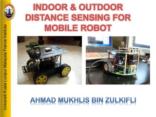
SlideShare a Scribd company logo
1 of 23
INDOOR & OUTDOOR
DISTANCE SENSING FOR
MOBILE ROBOT
INTRODUCTION
• Indoor Distance Sensing Mobile Robot
• Outdoor Distance Sensing Mobile Robot
OBJECTIVES
• Indoor distance sensing
– Develop microcontroller-based system for differential
driven mobile robot equipped with quadrature
encoder for distance sensing.
– To study, conduct experiments and produce document
on the indoor sensing.
• Outdoor distance sensing
– To interpret GPS data and produce document on GPS
navigation.
– Develop microcontroller-based system for driving
outdoor mobile robot and receive GPS data.
SCOPES
• Case study about both of the sensing device
• Programming the microcontroller
• Electrical and electronic development
LIMITATIONS
• Equalizing both of quadrature encoder sensor
• Understanding overall data from the GPS
Literature Review
• Quadrature Encoder
Features
•Operating voltage: 4.5 V to 5.5 V
•Two digital outputs (Output A and Output B)
•48 counts per revolution (linear resolution of just
under 3 mm or 1/8”)
Formula
24 ÷ 13.1964 = 1.8187 pulse – 1cm
Total pulse(s) = 1.8187D
24 – Total pulse per
rotation
13.1964 – Circumference
of the wheel
D – Total distance
RESEARCH METHODOLOGY
PROJECT DEVELOPMENT
• Indoor Distance Sensing Mobile Robot
Electrical/Electronic Development Process
Quadrature encoder, gear motor, motor shield and
microcontroller wiring process
Display output (LCD) wiring process
Software Development Process
• Outdoor Distance Sensing Mobile Robot
 Electrical/Electronic Development Process
GPS module, GPS shield and microcontroller wiring process
DC Motor, microcontroller and motor shield wiring process
 Software Development Process
QUADRATURE ENCODER, GEAR MOTOR, MOTOR SHIELD AND
MICROCONTROLLER WIRING PROCESS
*Click the picture to
play the animation
DISPLAY OUTPUT (LCD) WIRING PROCESS
*Click the picture to
play the animation
SOFTWARE DEVELOPMENT PROCESS
START
Input Signal at
pins by encoders
for 1set encoder
(High / Low)
Calculate pulses =
1.8 x distance
If both output
is High
Input
distance in
cm
NO
YES
If Pushbutton
1 / 2 / 3 press
YES
NO
Motor running
according to
quantity pulses
and stop
Display distance
and quantity of
pulses for both
encoder
END
GPS MODULE, GPS SHIELD AND MICROCONTROLLER
WIRING PROCESS
*Click the picture to
play the animation
DC MOTOR, MICROCONTROLLER & MOTOR SHIELD
WIRING PROCESS
*Click the picture to
play the animation
SOFTWARE DEVELOPMENT PROCESS
START
Check activation
of GPS receiver
Get data using
NMEA instruction
Display
Latitude and
Longitude at
LCD
END
TESTING & RESULT
• Hardware Testing Process
– Quadrature Encoder
– GPS Engine Board (GPS module)
• Software Testing Process
• Final Result
– Testing Result for Indoor Distance Sensing Mobile
Robot
– Final Result for Outdoor Distance Sensing Mobile
Robot
Testing on Quadrature Encoder
Number of rotation Pulse Distance (mm)
1 24 131.964
2 36 395.892
3 48 527.856
4 60 659.820
5 72 923.748
Testing on GPS Engine Board
(GPS Module)
Software Testing Process
Operation Block Diagram for Programming
Process
Testing Result for Indoor
Distance Sensing Mobile Robot
Distance
(mm)
Pulse(s) Error 1
(mm)
Error2
(mm)
Error3
(mm)
Error 4
(mm)
Error 5
(mm)
Average of Error
(mm)
40 73 9 8 9 10 7 8.6
80 146 12 12 12 12 11 11.8
120 219 14 13 13 14 15 13.8
160 291 16 13 16 15 15 15.0
200 364 24 23 23 16 17 20.6
240 437 26 23 24 23 25 24.2
280 510 36 34 35 33 35 34.6
320 582 36 34 36 36 34 35.2
360 655 38 38 37 39 38 38.0
400 728 45 44 45 39 39 42.4
Distance
(mm)
Pulse(s) Error 1
(mm)
Error2
(mm)
Error3
(mm)
Error 4
(mm)
Error 5
(mm)
Average of Error
(mm)
40 73 0 1 0 0 1 0.4
80 146 2 0 0 0 0 0.4
120 219 2 0 0 1 1 0.8
160 291 4 0 0 0 0 0.8
200 364 4 0 1 0 1 1.2
240 437 3 0 0 2 2 1.4
280 510 5 0 1 1 1 1.6
320 582 5 0 0 2 2 1.8
360 655 5 1 2 0 2 2.0
400 728 6 1 2 0 2 2.2
Ten differences distance record for Indoor Robot with full PWM
Ten differences distance record for Indoor Robot with half PWM
Testing Result for Outdoor
Distance Sensing Mobile Robot
Location Data GPS Module Google Maps Differences
1
(3/31 Road)
Latitude 2.93944 2.93942 0.00002
Longitude 101.7806 101.7803 0.00003
2
(Section 3 Petronas)
Latitude 2.93924 2.93923 0.00001
Longitude 101.7751 101.7755 0.00004
3
(Section 15 Ameerali)
Latitude 2.93293 2.93290 0.00003
Longitude 101.7689 101.7686 0.00003
4
(UKM)
Latitude 2.93020 2.93018 0.00002
Longitude 101.7771 101.7776 0.00005
5
(UniKEB)
Latitude 2.92687 2.92684 0.00003
Longitude 101.7735 101.7734 0.00001
6
(MFI)
Latitude 2.92815 2.92817 0.00002
Longitude 101.7583 101.7579 0.00004
7
(KPTM)
Latitude 2.93176 2.93176 0.00000
Longitude 101.7582 101.7580 0.00002
8
(Warta Mall)
Latitude 2.95283 2.95285 0.00002
Longitude 101.7571 101.7570 0.00001
9
(PKNS Mall)
Latitude 2.96202 2.96201 0.00001
Longitude 101.7570 101.7570 0.00000
10
(Section 1 Shell)
Latitude 2.94315 2.94320 0.00005
Longitude 101.7653 101.7650 0.00003
Ten differences location between GPS
Module and Google Maps
Testing Result for Outdoor
Distance Sensing Mobile Robot
Location Data GPS Module Google Maps Differences
Position 1 Latitude 2.93072 2.93075 0.00003
Longitude 101.7576 101.7578 0.00002
Position 2 Latitude 2.93065 2.93067 0.00002
Longitude 101.7576 101.7579 0.00003
Position 3 Latitude 2.93065 2.93069 0.00004
Longitude 101.7575 101.7577 0.00002
Position 4 Latitude 2.93075 2.93078 0.00003
Longitude 101.7577 101.7578 0.00001
GPS reading position location inside building
Four differences location in UniKL MFI building
Testing Result for Outdoor
Distance Sensing Mobile Robot
GPS reading position location outside building
Location Data GPS Module Google Maps Differences
Position 1 Latitude 2.93026 2.93027 0.00001
Longitude 101.7576 101.7579 0.00003
Position 2 Latitude 2.93027 2.93028 0.00001
Longitude 101.7576 101.7578 0.00002
Position 3 Latitude 2.93028 2.93029 0.00001
Longitude 101.7575 101.7576 0.00001
Position 4 Latitude 2.93023 2.93025 0.00002
Longitude 101.7574 101.7575 0.00001
Four differences location outside UniKL MFI building
CONCLUSION AND
RECOMMENDATION
• CONCLUSION
Achieve the objectives
Get knowledge about encoder operating systems
Get knowledge about GPS operating systems
• RECOMMENDATION
Deeper Research for quadrature encoder
Use additional hardware / features for more
efficiencies mobile robot.

More Related Content

What's hot

Gl300W GPS Tracker User Manual
Gl300W GPS Tracker User ManualGl300W GPS Tracker User Manual
Gl300W GPS Tracker User ManualRabius Sany
 
ACCIDENT DETECTION AND VEHICLE TRACKING USING GPS,GSM AND MEMS
ACCIDENT DETECTION AND VEHICLE TRACKING USING GPS,GSM AND MEMSACCIDENT DETECTION AND VEHICLE TRACKING USING GPS,GSM AND MEMS
ACCIDENT DETECTION AND VEHICLE TRACKING USING GPS,GSM AND MEMSKrishna Moparthi
 
Ds nemo outdoor 5.0
Ds nemo outdoor 5.0Ds nemo outdoor 5.0
Ds nemo outdoor 5.0Thanh Tran
 
GPS Based Vehicle Location using ARM 7 LPC 2148
GPS Based Vehicle Location using ARM 7 LPC 2148GPS Based Vehicle Location using ARM 7 LPC 2148
GPS Based Vehicle Location using ARM 7 LPC 2148IRJET Journal
 
Fujifilm - Argus e2v security
Fujifilm - Argus e2v securityFujifilm - Argus e2v security
Fujifilm - Argus e2v securityBernard Genoud
 
Gl320M series user manual v1.00
Gl320M series user manual v1.00Gl320M series user manual v1.00
Gl320M series user manual v1.00Rabius Sany
 
REAL-TIME VEHICLE LOCKING AND TRACKING SYSTEM USING GSM AND GPS TECHNOLOGY-A...
REAL-TIME VEHICLE  LOCKING AND TRACKING SYSTEM USING GSM AND GPS TECHNOLOGY-A...REAL-TIME VEHICLE  LOCKING AND TRACKING SYSTEM USING GSM AND GPS TECHNOLOGY-A...
REAL-TIME VEHICLE LOCKING AND TRACKING SYSTEM USING GSM AND GPS TECHNOLOGY-A...Sandeep Kunsoth
 
Vehicle Tracking System for School Bus by Arduino
Vehicle Tracking System for School Bus by ArduinoVehicle Tracking System for School Bus by Arduino
Vehicle Tracking System for School Bus by ArduinoIRJET Journal
 
Geek Camp 2014: Game Of Drones - Algorithms and hardware designs for Quadcopters
Geek Camp 2014: Game Of Drones - Algorithms and hardware designs for QuadcoptersGeek Camp 2014: Game Of Drones - Algorithms and hardware designs for Quadcopters
Geek Camp 2014: Game Of Drones - Algorithms and hardware designs for QuadcoptersShipeng Xu
 
Engineering@SotonPoster
Engineering@SotonPosterEngineering@SotonPoster
Engineering@SotonPosterchang liu
 
Automotive navigation system
Automotive navigation systemAutomotive navigation system
Automotive navigation systemNaveen Sihag
 
Gv53MG GPS Tracker User Manual
Gv53MG GPS Tracker User ManualGv53MG GPS Tracker User Manual
Gv53MG GPS Tracker User ManualRabius Sany
 
Gv75 mg user manual v1.01
Gv75 mg user manual v1.01Gv75 mg user manual v1.01
Gv75 mg user manual v1.01Rabius Sany
 
CE6404 ANNA UNIVERSITY Unit iii total station surveying
CE6404 ANNA UNIVERSITY Unit iii total station surveyingCE6404 ANNA UNIVERSITY Unit iii total station surveying
CE6404 ANNA UNIVERSITY Unit iii total station surveyingDr Gopikrishnan T
 
Vehicle tracking Using GPS,GSM & ARM7
Vehicle tracking Using GPS,GSM & ARM7Vehicle tracking Using GPS,GSM & ARM7
Vehicle tracking Using GPS,GSM & ARM7Ashutosh Upadhayay
 
Pentax GNSS
Pentax GNSSPentax GNSS
Pentax GNSSOpenmaps
 

What's hot (19)

Gl300W GPS Tracker User Manual
Gl300W GPS Tracker User ManualGl300W GPS Tracker User Manual
Gl300W GPS Tracker User Manual
 
ACCIDENT DETECTION AND VEHICLE TRACKING USING GPS,GSM AND MEMS
ACCIDENT DETECTION AND VEHICLE TRACKING USING GPS,GSM AND MEMSACCIDENT DETECTION AND VEHICLE TRACKING USING GPS,GSM AND MEMS
ACCIDENT DETECTION AND VEHICLE TRACKING USING GPS,GSM AND MEMS
 
Ds nemo outdoor 5.0
Ds nemo outdoor 5.0Ds nemo outdoor 5.0
Ds nemo outdoor 5.0
 
GPS Based Vehicle Location using ARM 7 LPC 2148
GPS Based Vehicle Location using ARM 7 LPC 2148GPS Based Vehicle Location using ARM 7 LPC 2148
GPS Based Vehicle Location using ARM 7 LPC 2148
 
Unmanned aerial vehicle
Unmanned aerial vehicleUnmanned aerial vehicle
Unmanned aerial vehicle
 
Fujifilm - Argus e2v security
Fujifilm - Argus e2v securityFujifilm - Argus e2v security
Fujifilm - Argus e2v security
 
Gl320M series user manual v1.00
Gl320M series user manual v1.00Gl320M series user manual v1.00
Gl320M series user manual v1.00
 
REAL-TIME VEHICLE LOCKING AND TRACKING SYSTEM USING GSM AND GPS TECHNOLOGY-A...
REAL-TIME VEHICLE  LOCKING AND TRACKING SYSTEM USING GSM AND GPS TECHNOLOGY-A...REAL-TIME VEHICLE  LOCKING AND TRACKING SYSTEM USING GSM AND GPS TECHNOLOGY-A...
REAL-TIME VEHICLE LOCKING AND TRACKING SYSTEM USING GSM AND GPS TECHNOLOGY-A...
 
Vehicle Tracking System for School Bus by Arduino
Vehicle Tracking System for School Bus by ArduinoVehicle Tracking System for School Bus by Arduino
Vehicle Tracking System for School Bus by Arduino
 
Geek Camp 2014: Game Of Drones - Algorithms and hardware designs for Quadcopters
Geek Camp 2014: Game Of Drones - Algorithms and hardware designs for QuadcoptersGeek Camp 2014: Game Of Drones - Algorithms and hardware designs for Quadcopters
Geek Camp 2014: Game Of Drones - Algorithms and hardware designs for Quadcopters
 
Engineering@SotonPoster
Engineering@SotonPosterEngineering@SotonPoster
Engineering@SotonPoster
 
Automotive navigation system
Automotive navigation systemAutomotive navigation system
Automotive navigation system
 
Gv53MG GPS Tracker User Manual
Gv53MG GPS Tracker User ManualGv53MG GPS Tracker User Manual
Gv53MG GPS Tracker User Manual
 
Gv75 mg user manual v1.01
Gv75 mg user manual v1.01Gv75 mg user manual v1.01
Gv75 mg user manual v1.01
 
CE6404 ANNA UNIVERSITY Unit iii total station surveying
CE6404 ANNA UNIVERSITY Unit iii total station surveyingCE6404 ANNA UNIVERSITY Unit iii total station surveying
CE6404 ANNA UNIVERSITY Unit iii total station surveying
 
GPSGSM
GPSGSMGPSGSM
GPSGSM
 
Vehicle tracking Using GPS,GSM & ARM7
Vehicle tracking Using GPS,GSM & ARM7Vehicle tracking Using GPS,GSM & ARM7
Vehicle tracking Using GPS,GSM & ARM7
 
Pentax GNSS
Pentax GNSSPentax GNSS
Pentax GNSS
 
Gts250 e
Gts250 eGts250 e
Gts250 e
 

Similar to Indoor & outdoor distance sensing mobile robot

Spectra 082119953499
Spectra 082119953499Spectra 082119953499
Spectra 082119953499Budi anto
 
Brosur spectra 082119953499
Brosur spectra 082119953499Brosur spectra 082119953499
Brosur spectra 082119953499Budi anto
 
Brosur spectra Call 082119953499
Brosur spectra Call 082119953499Brosur spectra Call 082119953499
Brosur spectra Call 082119953499Budi anto
 
082119953499 Brosur spectra
082119953499 Brosur spectra082119953499 Brosur spectra
082119953499 Brosur spectraBudi anto
 
Total station and its application to civil engineering
Total station and its application to civil engineeringTotal station and its application to civil engineering
Total station and its application to civil engineeringTushar Dholakia
 
GPS Assisted Roadmapping and Vehicle Monitoring
GPS Assisted Roadmapping and Vehicle Monitoring GPS Assisted Roadmapping and Vehicle Monitoring
GPS Assisted Roadmapping and Vehicle Monitoring Niranjan Shintre
 
Total station Advanced Surveying Instrument
Total station Advanced Surveying InstrumentTotal station Advanced Surveying Instrument
Total station Advanced Surveying Instrumentsapna80328
 
Vehicle Tracking System by Arduino UNO
Vehicle Tracking System by Arduino UNOVehicle Tracking System by Arduino UNO
Vehicle Tracking System by Arduino UNOPulkit Singhal
 
Automatic Vehicle Locator(AVL) Seminar report
 Automatic Vehicle Locator(AVL) Seminar report Automatic Vehicle Locator(AVL) Seminar report
Automatic Vehicle Locator(AVL) Seminar reportRohit Kumar patel
 
Surveying,ADVANCE EQUIPMENT IN SURVEY
Surveying,ADVANCE EQUIPMENT  IN SURVEYSurveying,ADVANCE EQUIPMENT  IN SURVEY
Surveying,ADVANCE EQUIPMENT IN SURVEYPRAJWAL SHRIRAO
 
Gps based vehicle monitoring system copy
Gps based vehicle monitoring system   copyGps based vehicle monitoring system   copy
Gps based vehicle monitoring system copySumit Varshney
 
IRJET - Detection of Landmine using Robotic Vehicle
IRJET -  	  Detection of Landmine using Robotic VehicleIRJET -  	  Detection of Landmine using Robotic Vehicle
IRJET - Detection of Landmine using Robotic VehicleIRJET Journal
 
Advanced Anti Accidental Solution by Pre Analyzing, Tracking and Detection of...
Advanced Anti Accidental Solution by Pre Analyzing, Tracking and Detection of...Advanced Anti Accidental Solution by Pre Analyzing, Tracking and Detection of...
Advanced Anti Accidental Solution by Pre Analyzing, Tracking and Detection of...IRJET Journal
 
Real-Time Map Building using Ultrasound Scanning
Real-Time Map Building using Ultrasound ScanningReal-Time Map Building using Ultrasound Scanning
Real-Time Map Building using Ultrasound ScanningIRJET Journal
 
Geomatics for emergency management
Geomatics for emergency managementGeomatics for emergency management
Geomatics for emergency managementSalvatore Morreale
 
Adaptive Hyper-Parameter Tuning for Black-box LiDAR Odometry [IROS2021]
Adaptive Hyper-Parameter Tuning for Black-box LiDAR Odometry [IROS2021]Adaptive Hyper-Parameter Tuning for Black-box LiDAR Odometry [IROS2021]
Adaptive Hyper-Parameter Tuning for Black-box LiDAR Odometry [IROS2021]KenjiKoide1
 

Similar to Indoor & outdoor distance sensing mobile robot (20)

Spectra 082119953499
Spectra 082119953499Spectra 082119953499
Spectra 082119953499
 
Brosur spectra 082119953499
Brosur spectra 082119953499Brosur spectra 082119953499
Brosur spectra 082119953499
 
Brosur spectra Call 082119953499
Brosur spectra Call 082119953499Brosur spectra Call 082119953499
Brosur spectra Call 082119953499
 
082119953499 Brosur spectra
082119953499 Brosur spectra082119953499 Brosur spectra
082119953499 Brosur spectra
 
Total station and its application to civil engineering
Total station and its application to civil engineeringTotal station and its application to civil engineering
Total station and its application to civil engineering
 
Total station
Total station Total station
Total station
 
GPS Assisted Roadmapping and Vehicle Monitoring
GPS Assisted Roadmapping and Vehicle Monitoring GPS Assisted Roadmapping and Vehicle Monitoring
GPS Assisted Roadmapping and Vehicle Monitoring
 
Total station Advanced Surveying Instrument
Total station Advanced Surveying InstrumentTotal station Advanced Surveying Instrument
Total station Advanced Surveying Instrument
 
Vehicle Tracking System by Arduino UNO
Vehicle Tracking System by Arduino UNOVehicle Tracking System by Arduino UNO
Vehicle Tracking System by Arduino UNO
 
Automatic Vehicle Locator(AVL) Seminar report
 Automatic Vehicle Locator(AVL) Seminar report Automatic Vehicle Locator(AVL) Seminar report
Automatic Vehicle Locator(AVL) Seminar report
 
Surveying,ADVANCE EQUIPMENT IN SURVEY
Surveying,ADVANCE EQUIPMENT  IN SURVEYSurveying,ADVANCE EQUIPMENT  IN SURVEY
Surveying,ADVANCE EQUIPMENT IN SURVEY
 
Surveying
Surveying Surveying
Surveying
 
Gps based vehicle monitoring system copy
Gps based vehicle monitoring system   copyGps based vehicle monitoring system   copy
Gps based vehicle monitoring system copy
 
IRJET - Detection of Landmine using Robotic Vehicle
IRJET -  	  Detection of Landmine using Robotic VehicleIRJET -  	  Detection of Landmine using Robotic Vehicle
IRJET - Detection of Landmine using Robotic Vehicle
 
Advanced Anti Accidental Solution by Pre Analyzing, Tracking and Detection of...
Advanced Anti Accidental Solution by Pre Analyzing, Tracking and Detection of...Advanced Anti Accidental Solution by Pre Analyzing, Tracking and Detection of...
Advanced Anti Accidental Solution by Pre Analyzing, Tracking and Detection of...
 
Real-Time Map Building using Ultrasound Scanning
Real-Time Map Building using Ultrasound ScanningReal-Time Map Building using Ultrasound Scanning
Real-Time Map Building using Ultrasound Scanning
 
Geomatics for emergency management
Geomatics for emergency managementGeomatics for emergency management
Geomatics for emergency management
 
CHSurvey introduce
CHSurvey introduceCHSurvey introduce
CHSurvey introduce
 
Open-Source Based Direct Georeferencing Thermal Camera System
Open-Source Based Direct Georeferencing Thermal Camera SystemOpen-Source Based Direct Georeferencing Thermal Camera System
Open-Source Based Direct Georeferencing Thermal Camera System
 
Adaptive Hyper-Parameter Tuning for Black-box LiDAR Odometry [IROS2021]
Adaptive Hyper-Parameter Tuning for Black-box LiDAR Odometry [IROS2021]Adaptive Hyper-Parameter Tuning for Black-box LiDAR Odometry [IROS2021]
Adaptive Hyper-Parameter Tuning for Black-box LiDAR Odometry [IROS2021]
 

Indoor & outdoor distance sensing mobile robot

  • 1. INDOOR & OUTDOOR DISTANCE SENSING FOR MOBILE ROBOT
  • 2. INTRODUCTION • Indoor Distance Sensing Mobile Robot
  • 3. • Outdoor Distance Sensing Mobile Robot
  • 4. OBJECTIVES • Indoor distance sensing – Develop microcontroller-based system for differential driven mobile robot equipped with quadrature encoder for distance sensing. – To study, conduct experiments and produce document on the indoor sensing. • Outdoor distance sensing – To interpret GPS data and produce document on GPS navigation. – Develop microcontroller-based system for driving outdoor mobile robot and receive GPS data.
  • 5. SCOPES • Case study about both of the sensing device • Programming the microcontroller • Electrical and electronic development LIMITATIONS • Equalizing both of quadrature encoder sensor • Understanding overall data from the GPS
  • 6. Literature Review • Quadrature Encoder Features •Operating voltage: 4.5 V to 5.5 V •Two digital outputs (Output A and Output B) •48 counts per revolution (linear resolution of just under 3 mm or 1/8”) Formula 24 ÷ 13.1964 = 1.8187 pulse – 1cm Total pulse(s) = 1.8187D 24 – Total pulse per rotation 13.1964 – Circumference of the wheel D – Total distance
  • 8. PROJECT DEVELOPMENT • Indoor Distance Sensing Mobile Robot Electrical/Electronic Development Process Quadrature encoder, gear motor, motor shield and microcontroller wiring process Display output (LCD) wiring process Software Development Process • Outdoor Distance Sensing Mobile Robot  Electrical/Electronic Development Process GPS module, GPS shield and microcontroller wiring process DC Motor, microcontroller and motor shield wiring process  Software Development Process
  • 9. QUADRATURE ENCODER, GEAR MOTOR, MOTOR SHIELD AND MICROCONTROLLER WIRING PROCESS *Click the picture to play the animation
  • 10. DISPLAY OUTPUT (LCD) WIRING PROCESS *Click the picture to play the animation
  • 11. SOFTWARE DEVELOPMENT PROCESS START Input Signal at pins by encoders for 1set encoder (High / Low) Calculate pulses = 1.8 x distance If both output is High Input distance in cm NO YES If Pushbutton 1 / 2 / 3 press YES NO Motor running according to quantity pulses and stop Display distance and quantity of pulses for both encoder END
  • 12. GPS MODULE, GPS SHIELD AND MICROCONTROLLER WIRING PROCESS *Click the picture to play the animation
  • 13. DC MOTOR, MICROCONTROLLER & MOTOR SHIELD WIRING PROCESS *Click the picture to play the animation
  • 14. SOFTWARE DEVELOPMENT PROCESS START Check activation of GPS receiver Get data using NMEA instruction Display Latitude and Longitude at LCD END
  • 15. TESTING & RESULT • Hardware Testing Process – Quadrature Encoder – GPS Engine Board (GPS module) • Software Testing Process • Final Result – Testing Result for Indoor Distance Sensing Mobile Robot – Final Result for Outdoor Distance Sensing Mobile Robot
  • 16. Testing on Quadrature Encoder Number of rotation Pulse Distance (mm) 1 24 131.964 2 36 395.892 3 48 527.856 4 60 659.820 5 72 923.748
  • 17. Testing on GPS Engine Board (GPS Module)
  • 18. Software Testing Process Operation Block Diagram for Programming Process
  • 19. Testing Result for Indoor Distance Sensing Mobile Robot Distance (mm) Pulse(s) Error 1 (mm) Error2 (mm) Error3 (mm) Error 4 (mm) Error 5 (mm) Average of Error (mm) 40 73 9 8 9 10 7 8.6 80 146 12 12 12 12 11 11.8 120 219 14 13 13 14 15 13.8 160 291 16 13 16 15 15 15.0 200 364 24 23 23 16 17 20.6 240 437 26 23 24 23 25 24.2 280 510 36 34 35 33 35 34.6 320 582 36 34 36 36 34 35.2 360 655 38 38 37 39 38 38.0 400 728 45 44 45 39 39 42.4 Distance (mm) Pulse(s) Error 1 (mm) Error2 (mm) Error3 (mm) Error 4 (mm) Error 5 (mm) Average of Error (mm) 40 73 0 1 0 0 1 0.4 80 146 2 0 0 0 0 0.4 120 219 2 0 0 1 1 0.8 160 291 4 0 0 0 0 0.8 200 364 4 0 1 0 1 1.2 240 437 3 0 0 2 2 1.4 280 510 5 0 1 1 1 1.6 320 582 5 0 0 2 2 1.8 360 655 5 1 2 0 2 2.0 400 728 6 1 2 0 2 2.2 Ten differences distance record for Indoor Robot with full PWM Ten differences distance record for Indoor Robot with half PWM
  • 20. Testing Result for Outdoor Distance Sensing Mobile Robot Location Data GPS Module Google Maps Differences 1 (3/31 Road) Latitude 2.93944 2.93942 0.00002 Longitude 101.7806 101.7803 0.00003 2 (Section 3 Petronas) Latitude 2.93924 2.93923 0.00001 Longitude 101.7751 101.7755 0.00004 3 (Section 15 Ameerali) Latitude 2.93293 2.93290 0.00003 Longitude 101.7689 101.7686 0.00003 4 (UKM) Latitude 2.93020 2.93018 0.00002 Longitude 101.7771 101.7776 0.00005 5 (UniKEB) Latitude 2.92687 2.92684 0.00003 Longitude 101.7735 101.7734 0.00001 6 (MFI) Latitude 2.92815 2.92817 0.00002 Longitude 101.7583 101.7579 0.00004 7 (KPTM) Latitude 2.93176 2.93176 0.00000 Longitude 101.7582 101.7580 0.00002 8 (Warta Mall) Latitude 2.95283 2.95285 0.00002 Longitude 101.7571 101.7570 0.00001 9 (PKNS Mall) Latitude 2.96202 2.96201 0.00001 Longitude 101.7570 101.7570 0.00000 10 (Section 1 Shell) Latitude 2.94315 2.94320 0.00005 Longitude 101.7653 101.7650 0.00003 Ten differences location between GPS Module and Google Maps
  • 21. Testing Result for Outdoor Distance Sensing Mobile Robot Location Data GPS Module Google Maps Differences Position 1 Latitude 2.93072 2.93075 0.00003 Longitude 101.7576 101.7578 0.00002 Position 2 Latitude 2.93065 2.93067 0.00002 Longitude 101.7576 101.7579 0.00003 Position 3 Latitude 2.93065 2.93069 0.00004 Longitude 101.7575 101.7577 0.00002 Position 4 Latitude 2.93075 2.93078 0.00003 Longitude 101.7577 101.7578 0.00001 GPS reading position location inside building Four differences location in UniKL MFI building
  • 22. Testing Result for Outdoor Distance Sensing Mobile Robot GPS reading position location outside building Location Data GPS Module Google Maps Differences Position 1 Latitude 2.93026 2.93027 0.00001 Longitude 101.7576 101.7579 0.00003 Position 2 Latitude 2.93027 2.93028 0.00001 Longitude 101.7576 101.7578 0.00002 Position 3 Latitude 2.93028 2.93029 0.00001 Longitude 101.7575 101.7576 0.00001 Position 4 Latitude 2.93023 2.93025 0.00002 Longitude 101.7574 101.7575 0.00001 Four differences location outside UniKL MFI building
  • 23. CONCLUSION AND RECOMMENDATION • CONCLUSION Achieve the objectives Get knowledge about encoder operating systems Get knowledge about GPS operating systems • RECOMMENDATION Deeper Research for quadrature encoder Use additional hardware / features for more efficiencies mobile robot.