
Recommended
More Related Content
Similar to Zion National Park Formed by Water
Similar to Zion National Park Formed by Water (16)
Recently uploaded
Recently uploaded (20)
Zion National Park Formed by Water
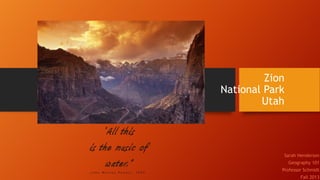
- 1. Zion National Park Utah “All this is the music of water.” -John Wesley Powell, 1895. Sarah Henderson Geography 101 Professor Schmidt Fall 2013
- 2. A Brief History… Anasazi Indians around 1300 B.C.E. (“Zion.” Map.) 1860’s, Mormon settlers became the first white people to occupy the area.(“Zion.” Map.) religious persecutions Isaac Behunin dubbed the canyon “Zion,” a reference to a place of peace.(“Zion.” Map.) fertile lands produced crops such as corn, tobacco, fruit trees, squashes.(“Zion.” Map.) The oldest National Park in Utah. (“Zion National Park.” Utah.com.)
- 3. Water in large volumes creates downcutting in the earth (Hess). Thousands of years to form. Millions of gallons of rushing water and debris filled water. Breath taking landforms also a result of shifting below earth’s surface(“Zion.” Map.) Weeping Rock Water actually leeks from the rock face giving the illusion of crying stone. Phenomenon can be seen tin other parts of the park. Water Created Zion The Subway The Narrows A naturally occurring tunnel shaped canyon, carved by water. Some repelling and some wading One of the most memorable hikes in Zion. Include steep natural walls on either side. 60% wading.
- 4. The Rim Less wooded, rocky, low plants, elk and a variety of birds.
- 5. Desert animals (bats, tarantulas, tortoise, and other reptiles). Some trees, mostly shrubs. The Canyon
- 6. The River Swamp like marshland in some areas. Frogs and lizards accompanied by deer that roam the canyons. ferns, and many trees, mostly Fremont Cottonwoods.
- 7. Virgin River Brings Life Feeds the Colorado river Brings life to the area Annual precipitation 15 inches.(“Zion.” Map.) Experiences high flooding and monsoon seasons in mid summer. (“Zion National Park: Map and Guide.”)
- 8. The Nature of Flash Floods Consistent danger in Zion (David). Occurs within 6 hours of a thunderstorm (“Flood.”) . Number 1 natural disaster with an average of 95 casualties (“Flood”). Considered life threatening (“Flood”). Flood up to 12 feet higher than typical water levels (“The Narrows”) .
- 9. Flash Flood Safety & Awareness Before heading out: Check and monitor weather conditions(“Flood.”) . Check for build up of thunder or clouds (“Zion National Park: Map and Guide.”). Be prepared Bring flashlight/ headlamp First aid kit Extra cloths, food, water. (“Flood.”) . rope While out on the trail: If you hear distant thunder rolling, leave as soon as possible! Cloudy or murky water More debris in the water Sudden change in water level A roaring of water in the distance Rapid waters (“Zion National Park: Map and Guide.”) Trust your instincts! Your survival is your responsibiliy In case of emergency: If possible, get to higher ground (“Flood.”) . Seek shelter behind large bolder. Trees will break! Do not attempt to cross rapids, even if it mean getting to safety (“Flood.”) .
- 10. In Conclusion Zion is full of natural beauty that brings in tourism from all over the world. The drastic physiological characteristics of Zion's canyons and its every changing environment has a great deal to do with the Virgin River. Some of the most popular hiking experiences can be treacherous due to flash flooding. Before heading out on a hike in any of the aqua/repelling hiking trails, check for good conditions, be prepared, and tell others where you will be, incase you become trapped If you are uncertain if there is a flash flood coming your way, look for signs. If you are caught in a flood, get to safe ground and stay put.
- 11. Works Cited David Day. “Zion Narrows.” Excerpt from Utah’s Incredible Backcountry Trails. Rincon Publishing Company.Web. Sept. 2013. http://www.utahtrails.com/backcountry%20pages/zionnarrows.html “Flood Safety Awareness Week.” National Weather Services.2013.NWS. 20 Sept. 2013. Web. http://www.srh.noaa.gov/media/jan/FSAW/FLOOD_WX_AWARNESS_2013.pdf Hess, Darrel. McKnight’s Physical Geography: A landscape Appreciation 10th ed. (251-449). New Jersey: Pearson Education, Inc. 2011. Print. “Zion.” Map. Zion National Park, Utah. National Park Service U.S. Department of the Interior, 2013. Print. “Zion National Park: Map and Guide.” The Official Newspaper of Zion National Park, Summer, 2013. National Park Service U.S. Department of the Interior. Print. “Zion National Park.” Utah.com, 2013. Utah Travel Industry Website. Web. 20 Sept. 2013. http://utah.com/nationalparks/zion.htm “The Narrows Safety.” Zion National Park Utah. National Park Service U.S. Department of the Interior 15 Nov. 2013. Web. 15 Nov. 2013. http://www.nps.gov/zion/planyourvisit/narrowssafety.htm