European fund distribution markets saw overall growth over the 12-month period ending July 2014. Germany, France, and Italy had the largest growth in total net assets held by local investors in domestic and cross-border funds. The heat map shows the annual growth rate of the major European distribution markets based on changes in total net assets. Germany had the largest distribution market size as of July 2014, followed by France and the UK.
Laura Luckey has extensive experience working as a special education teacher. She has a Bachelor's Degree in Special Education and state certifications in Special Education K-12 and English 7-12. Her student teaching experiences included placements in middle school and high school where she taught subjects like math, language arts, reading, social studies and science to students with learning support and emotional support needs. Currently she works as an Autistic Support Teacher in West Scranton. Previously she was a Special Education Teacher for 6th and 8th grade learning support. She has also worked as a daily substitute teacher and special education para-professional for 14 years assisting students with behavioral disorders, physical/cognitive deficits, and autism.
The document is a quiz for an introductory seismology course, testing knowledge of key terms. It contains multiple choice and true/false questions about topics like:
1) The study of earthquakes and seismic wave propagation through the Earth is called seismology.
2) Key layers of the Earth mentioned include the crust, mantle, outer core, and inner core.
3) Different types of seismic waves tested on include P waves, S waves, and surface waves like Love waves and Rayleigh waves.
اختصار وتحقيق: 1- الأستاذ صلاح بن محمد عرفات. 2- الأستاذ محمد بن عبدالله الشنقيطي. 3- الأستاذ خالد بن فوزي عبدالحميد. بإشراف: فضيلة الشيخ الدكتور صالح بن عبدالله بن حميد إمام وخطيب المسجد الحرام، ورئيس مجلس القضاء الأعلى.
This document describes experiments using lasers to penetrate and crack rocks. It discusses the lasers used, which were CO2 lasers with powers up to 18,000 watts. Experiments tested the penetration of quartzite, basalt, and granite samples using continuous wave laser beams focused on the rock surface. A computer program was also developed to model the thermal and mechanical stresses induced in rocks from laser irradiation in order to predict efficient cracking conditions. Preliminary results found that laser irradiation could potentially crack and remove rocks, though more energy was required than the computer models predicted. Further optimization of laser parameters could improve the effectiveness and efficiency of using lasers for rock excavation.
Sathika Jienjaroonsri is an interior architect in Thailand who graduated from Chulalongkorn University in 2011. She has worked as an interior architect at Onion Co., Ltd. on several projects including a private car garage, Sala Rattanakosin boutique hotel, and an ongoing riverside condominium development. Her thesis project was a knowledge center for Chachoengsao province inspired by activities along the local riverside. She is skilled in design, modeling, and construction documentation.
Jeofiziğin Geleceği Öğrenci Konferansı oldukça başarılı geçti. İstanbul'da yaşayan ve okuyan öğrenciler, öğretim üyeleri ve sektör temsilcileri buluştu, gelecekle ilgili önerilerini ve bugünle ilgili yaşanan hadiseleri paylaştı. Katkı veren tüm genç arkadaşlarımıza, iTÜ Öğrenci Kulübüne, iTÜ Bölüm Başkanına, ve iTÜ Maden Dekan Yardımcısına, ve katılan duayen hocalarımız ve meslektaşlarımıza, JFMO Öğrenci Komisyonu Üyelerine, Komisyon Başkanları Kemal Yılmaz ve Mehmet Yıldırıma çok teşekkürler.
Gravimetri Dersi için aşağıda ki videoları izleyebilirsiniz.
Link 01: https://www.youtube.com/watch?v=HTyjVaVGx0k
Link 02: https://www.youtube.com/watch?v=fUkfgI8XaOE
The document discusses gravity anomalies and density variations in different regions based on gravity data. It shows how gravity maps reveal details about crustal thickness, tectonic features like faults and volcanic zones, and plate boundaries. Specific examples discussed include the Tibetan Plateau, Central America subduction zone, an area in Chugoku, Japan, and the state of Florida in the US. Regional gravity data can be used to model density changes associated with plate tectonics, crustal evolution, and volcanic and tectonic activity.
The USF team reviewed a geophysical investigation of the Kar Kar region conducted by WesternGeco in 2011. They found that WesternGeco's magnetotelluric (MT) data and models were of high quality. Both the WesternGeco and USF MT models identified a low resistivity zone at 300m depth that correlates with a water-bearing zone found in Borehole 4. USF performed gravity modeling which identified a north-south trending basin reaching 1500m depth, consistent with mapped faults. A preliminary hydrothermal model suggested observed temperatures could result from deep circulation of meteoric waters in the basin without needing a localized heat source. Additional geophysical data is recommended around the Jermaghbyur hot springs to
This document summarizes a study that used gravity data to delineate underground structure in the Beppu geothermal field in Japan. Analysis of Bouguer anomaly maps revealed high anomalies in the southern and northern parts of the study area that correspond to known geological formations. Edge detection filtering of the gravity data helped identify subsurface faults, including the northern edge of the high southern anomaly corresponding to the Asamigawa Fault. Depth modeling of the gravity basement showed differences between the southern and northern hot spring areas, with steep basement slopes along faults in the south and uplifted basement in the north.
This document summarizes the development of a new ultra-high resolution model of Earth's gravity field called GGMplus. Key points:
- GGMplus combines satellite gravity data from GOCE and GRACE with terrestrial gravity data and topography to achieve unprecedented 200m spatial resolution globally.
- It provides gridded estimates of gravity, horizontal and radial field components, and quasi-geoid heights at over 3 billion points covering 80% of the Earth's land.
- GGMplus reveals new details of small-scale gravity variations and identifies locations of minimum and maximum gravity, suggesting peak-to-peak variations are 40% larger than previous estimates. The model will benefit scientific and engineering applications.
Gravity measurements were taken in a region of China covering the south-north earthquake belt in 1998, 2000, 2002, and 2005. Researchers noticed significant gravity changes in the region surrounding Wenchuan and suggested in 2006 that a major earthquake could occur there in 2007 or 2008. While gravity changes were significant at some locations, more research is needed to determine if they could be considered a precursor. Uncertainties exist from measurement errors, hydrologic effects, and crustal movements. Improved data collection and analysis could enhance using gravity monitoring for earthquake research.
The document provides guidelines for implementing the H/V spectral ratio technique using ambient vibration measurements to evaluate site effects. It recommends procedures for experimental design, data processing, and interpretation. The key recommendations include measuring for sufficient duration depending on expected frequency, using multiple measurement points, avoiding disturbances, and interpreting H/V peaks in context with geological and geophysical data. Reliable H/V peaks are defined as having a clear maximum within expected frequency ranges and uncertainties. The guidelines aim to help apply the technique while accounting for its limitations.
Geopsy yaygın olarak kullanılan profesyonel bir program. Özellikle, profesyonel program deneyimi yeni mezunlarda çok aranan bir özellik. Bir öğrencim çalışmasında kullanmayı planlıyor.
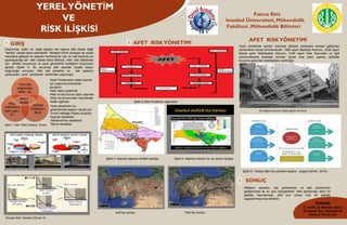
1. YERELYÖNETİM
VE
RİSK İLİŞKİSİ
Afetlerin zararları, risk yönetiminin ve afet yönetiminin
geliştirilmesi ile en aza indirgenebilir. Afet planlaması etkin bir
şekilde hazırlanmalı, afet olur olmaz hızlı bir şekilde
uygulanmaya koyulmalıdır.
Fatma Ekiz
İstanbul Üniversitesi, Mühendislik
Fakültesi ,Mühendislik Bilimleri
GİRİŞ
AFET RİSKYÖNETİMİ
SONUÇ
Kaynak
E. Tevfik, D. Mehmet, Afyon
Kocatepe Ünv.. Kadıoğlu M.
İstanbul Teknik ünv.
1
3
TEHLİKE
(depremler,
seller, vb.)
ZARAR
GÖREBİLİ
RLİK
RİSK
UNSURU(i
nsan,yapı,v
b.)
Şekil-4: İstanbul sismik hız ve zemin haritası
AFET
RİSKİ
Şekil 1: Afet Riski Oluşma Süreci
Depremler, seller vb. doğa olayları tek başına afet olarak değil
“tehlike” olarak kabul edilmelidir. Yerleşim birimi olmayan bir yerde
meydana gelecek bir deprem herhangi bir can ve mal kaybına yol
açamayacağı için afet olarak kabul edilmez. Afet riski olabilmesi
için tehlike unsurunun ve zarar görebilirlik özelliğinin bulunması
gerekir (Şekil 1). Bu durumda afet olaydan ziyade olayın
doğurduğu sonuçtur. Afet risk yönetimi ve risk azaltımı
çalışmaları yerel yönetimler tarafından yapılmıştır
2
Yerel yönetimler kentler üzerinde aldıkları kararlarla kentsel gelişmeyi
yönlendiren temel birimlerdendir. 1580 sayılı Belediye Kanunu, 3030 sayılı
Büyük şehir Belediyeleri Kanunu, 3194 sayılı İmar Kanunları ve ilgili
yönetmeliklerle belediye sınırları içinde imar planı yapma, tadilatta
bulunma görevleri belediyelere verilmiştir.
AFET RİSKYÖNETİMİ
Yerel yönetimler bu
görevlerinde başarılı olmak için
3 türlü desteğe ihtiyaç duyarlar:
Kaynak destekleri
Yetkilendirme destekleri
Teknik destekler
Yerel Yönetimlerin afete hazırlık
için yasal sorumlulukları
şunlardır:
•Afet riskini azaltmak
•Afet ve acil durum planı yapmak
•Ekip ve donanımları hazırlamak
•Halkı eğitmek Şekil-2:Afet Yönetimin aşamaları
Şekil-5: Türkiye afet risk yönetim sistemi projesi (AFAD ,2014)
Şekil-3: İstanbul deprem tehlike haritası
Küresel Risk Yönetimi (Öncel. A)
Sıvılaşma sonucu hasar gören bir bina
Aktif fay haritası Pasif fay haritası