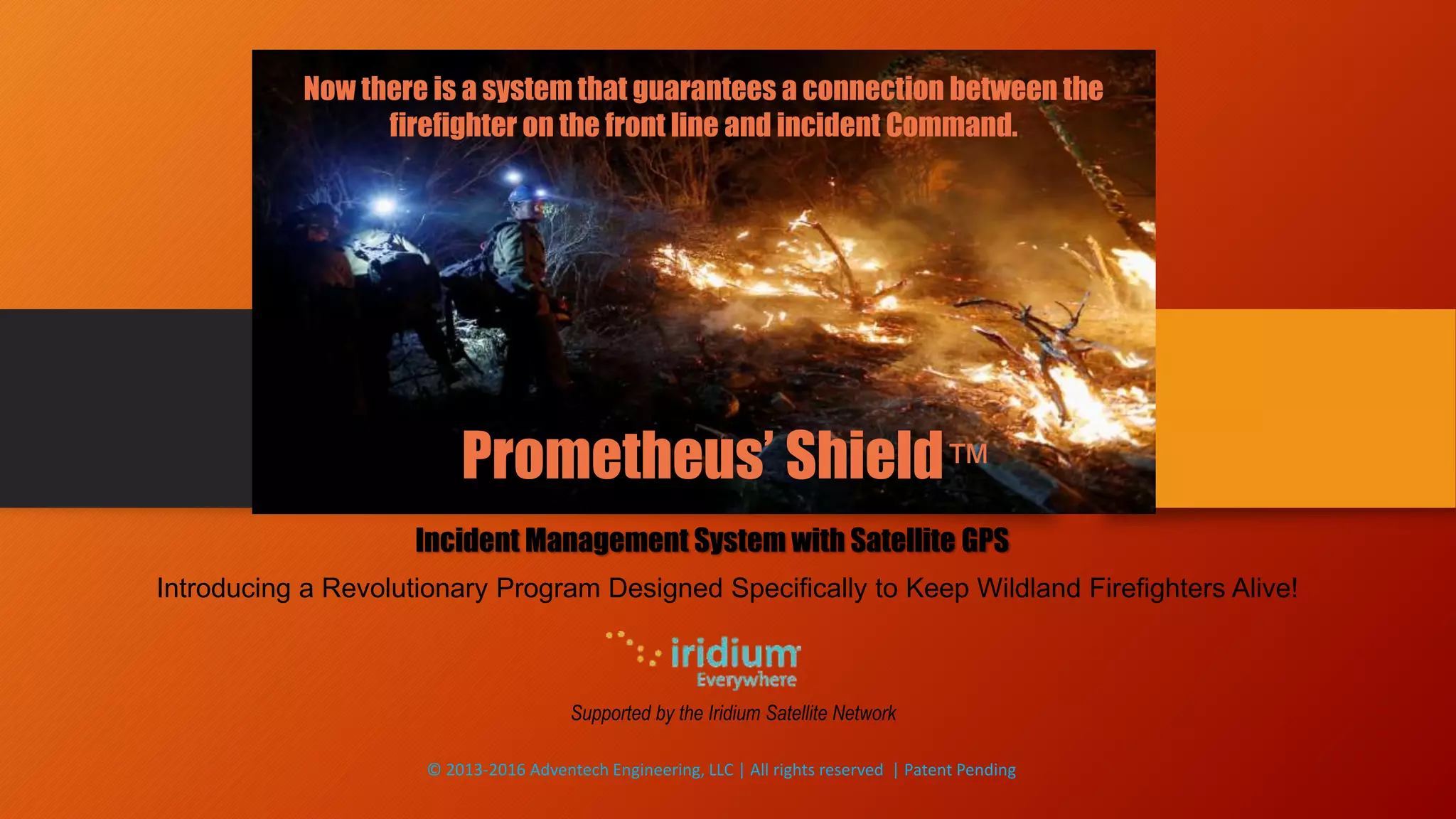
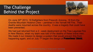
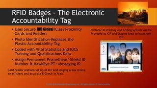
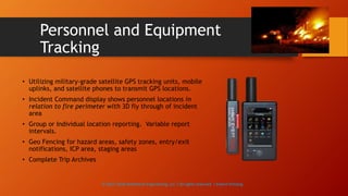
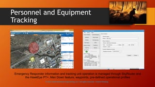
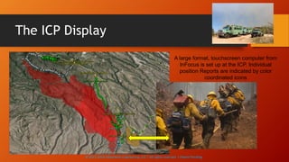
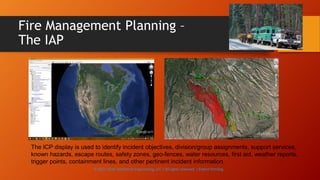
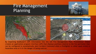
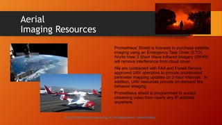
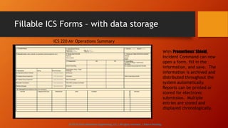
Prometheus’ Shield™
Incident Management System with Satellite GPS
Supported by the Iridium Satellite Network
Introducing a Revolutionary Program Designed Specifically to Keep Wildland Firefighters Alive!
Now there is a system that guarantees a connection between the
firefighter on the front line and incident Command.
© 2013-2016 Adventech Engineering, LLC | All rights reserved | Patent Pending
The Challenge
Behind the Project
On June 30th 2013, 19 firefighters from Prescott, Arizona, 18 from the
Granite Mountain Hotshot Crew – perished in the Yarnell Hill Fire. Their
deaths were mourned across the country. It was a tragedy that could have
been prevented.
We had just returned from a 2 - week deployment on the Tres Lagunas Fire
in New Mexico, when my team was told of the deaths of these brave men.
We made it our mission to design a system that would prevent this from
happening again, and on July 1st began the design of Prometheus’ Shield.
© 2013-2016 Adventech Engineering, LLC | All rights reserved | Patent Pending
Our Solution
“The mission objective was simple – create a guaranteed
communications link between the firefighter and incident command,
regardless of their location.
Unfortunately, the mission plan proved to be a little more complex.”
- Bill King
Senior Design Engineer
© 2013-2016 Adventech Engineering, LLC | All rights reserved | Patent Pending
Primary System
Applications
• RFID Identification (RFID Photo Badge)
• Personnel and Equipment Management (GIS Mapping)
• Incident Action Planning and Resource Management
• Satellite, Aerial, and Ground Imaging
• National Information Management System (NIMS) & Incident Command
System (ICS) Reporting
Prometheus’ Shield is a proprietary set of applications developed to create a satellite-based, interactive
planning and management tool for Wildland Fire Incident Commanders. The program includes a real-time
GIS mapping application that displays the movements of firefighters and their equipment in relation to the
fire perimeter. Information is managed by 5 subsystems that Prometheus’ Shield uses to capture and store
incident data.
© 2013-2016 Adventech Engineering, LLC | All rights reserved | Patent Pending
RFID Badges - The Electronic
Accountability Tag
• Uses Secure HID Global iClass Proximity
Cards and Readers
• Photo Identification–Replaces the
Plastic Accountability Tag
• Coded with Vital Statistics and IQCS
Training and Qualifications Data
• Assign Permanent Prometheus’ Shield ID
Number & HawkEye PT+ Messaging ID
Portable ID Printing and Coding System will be
Provided at ICP and Staging Area to issue new
ID’s
Card reader stations set up at ICP and staging areas create
an efficient and accurate E-Check in Area.
© 2013-2016 Adventech Engineering, LLC | All rights reserved | Patent Pending
Personnel and Equipment
Tracking
• Utilizing military-grade satellite GPS tracking units, mobile
uplinks, and satellite phones to transmit GPS locations.
• Incident Command display shows personnel locations in
relation to fire perimeter with 3D fly through of incident
area
• Group or Individual location reporting. Variable report
intervals.
• Geo Fencing for hazard areas, safety zones, entry/exit
notifications, ICP area, staging areas
• Complete Trip Archives
© 2013-2016 Adventech Engineering, LLC | All rights reserved | Patent Pending
Personnel and Equipment
Tracking
Emergency Responder information and tracking unit operation is managed through SkyRouter and
the HawkEye PT+. Man Down feature, waypoints, pre-defined operational profiles
© 2013-2016 Adventech Engineering, LLC | All rights reserved | Patent Pending
The ICP Display
A large format, touchscreen computer from
InFocus is set up at the ICP. Individual
position Reports are indicated by color
coordinated icons
© 2013-2016 Adventech Engineering, LLC | All rights reserved | Patent Pending
Fire Management Planning –
The IAP
The ICP display is used to identify incident objectives, division/group assignments, support services,
known hazards, escape routes, safety zones, geo-fences, water resources, first aid, weather reports,
trigger points, containment lines, and other pertinent incident information.
© 2013-2016 Adventech Engineering, LLC | All rights reserved | Patent Pending
Fire Management
Planning
By importing SkyRouter’s GPS information into the GIS Fire Management Plan, Prometheus’ Shield
creates an application program interface (API) that displays positions relative to the fire perimeter that
can be configured to automatically alert Incident Command when a firefighter or other asset enters a
hazardous area or is in the danger of being overrun.
© 2013-2016 Adventech Engineering, LLC | All rights reserved | Patent Pending
Aerial
Imaging Resources
Prometheus’ Shield is licensed to purchase satellite
imaging using an Emergency Task Order (ETO).
World-View 3 Short Wave Infrared Imagery (SWIR)
will remove interference from cloud cover.
We are contracted with FAA and Forest Service
approved UAV operators to provide coordinated
perimeter mapping updates on 2-hour intervals. In
addition, UAV resources provide on-demand fire
behavior imaging.
Prometheus shield is programmed to accept
streaming video from nearly any IP address
anywhere.
© 2013-2016 Adventech Engineering, LLC | All rights reserved | Patent Pending
National Information Management
System (NIMS) Reporting
• All required ICS forms have been converted into web-based fillable forms
that capture all incident data
• All forms were created from the National Information Management
System. Forms can be printed or stored for electronic submission
• Critical information displayed in datasheet form. All information
immediately available throughout incident website
• Data used later for fire behavior analysis
© 2013-2016 Adventech Engineering, LLC | All rights reserved | Patent Pending
Fillable ICS Forms – with data storage
ICS 220 Air Operations Summary
With Prometheus’ Shield,
Incident Command can now
open a form, fill in the
information, and save. The
information is archived and
distributed throughout the
system automatically.
Reports can be printed or
stored for electronic
submission. Multiple
entries are stored and
displayed chronologically.
© 2013-2016 Adventech Engineering, LLC | All rights reserved | Patent Pending

Wildland Firefighter Protection Service

  • 1.
    Prometheus’ Shield™ Incident ManagementSystem with Satellite GPS Supported by the Iridium Satellite Network Introducing a Revolutionary Program Designed Specifically to Keep Wildland Firefighters Alive! Now there is a system that guarantees a connection between the firefighter on the front line and incident Command. © 2013-2016 Adventech Engineering, LLC | All rights reserved | Patent Pending
  • 2.
    The Challenge Behind theProject On June 30th 2013, 19 firefighters from Prescott, Arizona, 18 from the Granite Mountain Hotshot Crew – perished in the Yarnell Hill Fire. Their deaths were mourned across the country. It was a tragedy that could have been prevented. We had just returned from a 2 - week deployment on the Tres Lagunas Fire in New Mexico, when my team was told of the deaths of these brave men. We made it our mission to design a system that would prevent this from happening again, and on July 1st began the design of Prometheus’ Shield. © 2013-2016 Adventech Engineering, LLC | All rights reserved | Patent Pending
  • 3.
    Our Solution “The missionobjective was simple – create a guaranteed communications link between the firefighter and incident command, regardless of their location. Unfortunately, the mission plan proved to be a little more complex.” - Bill King Senior Design Engineer © 2013-2016 Adventech Engineering, LLC | All rights reserved | Patent Pending
  • 4.
    Primary System Applications • RFIDIdentification (RFID Photo Badge) • Personnel and Equipment Management (GIS Mapping) • Incident Action Planning and Resource Management • Satellite, Aerial, and Ground Imaging • National Information Management System (NIMS) & Incident Command System (ICS) Reporting Prometheus’ Shield is a proprietary set of applications developed to create a satellite-based, interactive planning and management tool for Wildland Fire Incident Commanders. The program includes a real-time GIS mapping application that displays the movements of firefighters and their equipment in relation to the fire perimeter. Information is managed by 5 subsystems that Prometheus’ Shield uses to capture and store incident data. © 2013-2016 Adventech Engineering, LLC | All rights reserved | Patent Pending
  • 5.
    RFID Badges -The Electronic Accountability Tag • Uses Secure HID Global iClass Proximity Cards and Readers • Photo Identification–Replaces the Plastic Accountability Tag • Coded with Vital Statistics and IQCS Training and Qualifications Data • Assign Permanent Prometheus’ Shield ID Number & HawkEye PT+ Messaging ID Portable ID Printing and Coding System will be Provided at ICP and Staging Area to issue new ID’s Card reader stations set up at ICP and staging areas create an efficient and accurate E-Check in Area. © 2013-2016 Adventech Engineering, LLC | All rights reserved | Patent Pending
  • 6.
    Personnel and Equipment Tracking •Utilizing military-grade satellite GPS tracking units, mobile uplinks, and satellite phones to transmit GPS locations. • Incident Command display shows personnel locations in relation to fire perimeter with 3D fly through of incident area • Group or Individual location reporting. Variable report intervals. • Geo Fencing for hazard areas, safety zones, entry/exit notifications, ICP area, staging areas • Complete Trip Archives © 2013-2016 Adventech Engineering, LLC | All rights reserved | Patent Pending
  • 7.
    Personnel and Equipment Tracking EmergencyResponder information and tracking unit operation is managed through SkyRouter and the HawkEye PT+. Man Down feature, waypoints, pre-defined operational profiles © 2013-2016 Adventech Engineering, LLC | All rights reserved | Patent Pending
  • 8.
    The ICP Display Alarge format, touchscreen computer from InFocus is set up at the ICP. Individual position Reports are indicated by color coordinated icons © 2013-2016 Adventech Engineering, LLC | All rights reserved | Patent Pending
  • 9.
    Fire Management Planning– The IAP The ICP display is used to identify incident objectives, division/group assignments, support services, known hazards, escape routes, safety zones, geo-fences, water resources, first aid, weather reports, trigger points, containment lines, and other pertinent incident information. © 2013-2016 Adventech Engineering, LLC | All rights reserved | Patent Pending
  • 10.
    Fire Management Planning By importingSkyRouter’s GPS information into the GIS Fire Management Plan, Prometheus’ Shield creates an application program interface (API) that displays positions relative to the fire perimeter that can be configured to automatically alert Incident Command when a firefighter or other asset enters a hazardous area or is in the danger of being overrun. © 2013-2016 Adventech Engineering, LLC | All rights reserved | Patent Pending
  • 11.
    Aerial Imaging Resources Prometheus’ Shieldis licensed to purchase satellite imaging using an Emergency Task Order (ETO). World-View 3 Short Wave Infrared Imagery (SWIR) will remove interference from cloud cover. We are contracted with FAA and Forest Service approved UAV operators to provide coordinated perimeter mapping updates on 2-hour intervals. In addition, UAV resources provide on-demand fire behavior imaging. Prometheus shield is programmed to accept streaming video from nearly any IP address anywhere. © 2013-2016 Adventech Engineering, LLC | All rights reserved | Patent Pending
  • 12.
    National Information Management System(NIMS) Reporting • All required ICS forms have been converted into web-based fillable forms that capture all incident data • All forms were created from the National Information Management System. Forms can be printed or stored for electronic submission • Critical information displayed in datasheet form. All information immediately available throughout incident website • Data used later for fire behavior analysis © 2013-2016 Adventech Engineering, LLC | All rights reserved | Patent Pending
  • 13.
    Fillable ICS Forms– with data storage ICS 220 Air Operations Summary With Prometheus’ Shield, Incident Command can now open a form, fill in the information, and save. The information is archived and distributed throughout the system automatically. Reports can be printed or stored for electronic submission. Multiple entries are stored and displayed chronologically. © 2013-2016 Adventech Engineering, LLC | All rights reserved | Patent Pending