SlideShare a Scribd company logo
1 of 3
The Question of Vessel Squat
I use the grounding of the Queen Elizabeth 2 here for demonstration purposes only
At the trial of the grounding of the QE 2 in New York District court there were two
expert witnesses who testified regarding vessel squat. The expert witness hired
by the American Government testified that the QE 2 could have been
experiencing as much as 8 feet of squat. The expert witness hired by the plaintiff,
and who was from England, thought that she may have been experiencing less
than half of that.
As managers and surveyors of hydrographic vessel, how do you compensate
your depth measurements for the squat factor?
The following will give you a quantitative measure of the absolute value for the
squat that this vessel was experiencing while traveling at a speed of over 20
knots in depths ranging from 36 feet to 50 feet.
I will use, for demonstrative purposes, two illustrations provided by the Captain of
the NOAA vessel “Rude”, and who conducted the investigation into the QE 2
grounding.
This echo sounding trace was taken from the sounder of the QE 2 on August 7th
1992
At the time of the grounding there was a tidal height of 1.5 feet and the QE 2 was drawing 32.4
feet of water.
On August 7, 1992 at 21:44 hrs the sounding trace above shows that the ship
came extremely close to the bottom near the NA buoy on the chart. (See attached
illustration for a copy of the chart and the ships position). The 1966 NOAA measured depth at
this position was 36 feet and was shown on the chart. Therefore, we have the
following:
 Charted depth, NOAA 1966…….36 feet
 Height of tide…… 1.5 feet
 Therefore water over the bottom was ……37.5 feet
 The ship was drawing…… 32.4 feet
 Let’s say that she cleared the bottom by…… 0.5 feet as the graph shows
 Therefore her squat was……. 4.6 feet
Let’s look at the depth of water she was traveling over at this time. For some
length of time, 2 to 3 minutes, leading up to this near grounding she was in water
of 40 feet and less. Experts know that the shallower the water and the greater the
speed the more squat will be experienced.
Fourteen minutes later she grazed a boulder that was described as a glacial
erratic standing about 10 to 20 feet off the bottom. The depth of this boulder was
measured to be 34.5 feet and the surrounding water was in excess of 40 feet
with most of it being 40 to 50 feet. The ship was within the 50-foot surrounding
contour, as shown on the 1939 smooth sheet. This would place the ship in water
deeper than the “almost grounding” 14 minutes earlier. Let’s look at the squat
numbers.
 Charted depth “Rude” 1997……….. 34.5 feet (grazed)
 Height of tide……….. 1.5 feet
 Therefore water over the grazed site……….. 36.0 feet
 The ship was drawing…….. 32.4 feet
 Therefore the squat was………. 3.6 feet
For the most part, and except for the odd isolated boulder, the ship was traveling
in excess of 20 knots across an area that was slightly less than 50 feet in depth
with isolated boulders having water over them of less than 31 feet but widely
spaced. I doubt very much that boulders widely spaced could be considered
shallow water as the ship would be over any one of them for such a short time
and therefore would not accentuate or contribute to the squat factor.
Please refer to this illustration for points referred to in the body of this article
So what does this exercise tell us about vessel squat? In the first “near
grounding” the ship had not reached her intended speed of 20 knots plus but had
almost grounded with a squat of 4.6 feet. After reaching her speed of 20 knots
plus and in deeper water she grounded with 3.6 feet of squat.
Therefore, I believe the evidence is clear and indicates that this vessels hull
squat characteristic are in the range of 3.6 to 4.6 feet when she travels across
water depths of 40 to 50 feet at speeds of 20 plus knots. In deeper water squat
would be less and in shallower water it would be more as shown by the amount
of squat at the NA buoy.
If your survey vessel had the same hull characteristics as the QE 2 and was
conducting hydrographic survey depth measurements in water such as these and
at speed such as these then you would be required to apply a depth
measurement correction of 3.6 feet. Are you applying a squat correction and
have you determined the squat characteristics of all your vessels?

More Related Content

Viewers also liked (18)

EAHC S-100 seminar-forum, non charted information based on S-100
EAHC S-100 seminar-forum, non charted information based on S-100EAHC S-100 seminar-forum, non charted information based on S-100
EAHC S-100 seminar-forum, non charted information based on S-100
 
BLAST Marine Data Collection System
BLAST Marine Data Collection SystemBLAST Marine Data Collection System
BLAST Marine Data Collection System
 
chartbook
chartbookchartbook
chartbook
 
UNCLOS III
UNCLOS IIIUNCLOS III
UNCLOS III
 
Qe 2 Final Copy
Qe 2 Final CopyQe 2 Final Copy
Qe 2 Final Copy
 
United nations clos
United nations closUnited nations clos
United nations clos
 
Ship failure
Ship failureShip failure
Ship failure
 
Ship interactions online
Ship interactions onlineShip interactions online
Ship interactions online
 
Marine hydrodynamics
Marine hydrodynamicsMarine hydrodynamics
Marine hydrodynamics
 
The Squat: An Analysis
The Squat: An AnalysisThe Squat: An Analysis
The Squat: An Analysis
 
Basics of-ship-resistance
Basics of-ship-resistanceBasics of-ship-resistance
Basics of-ship-resistance
 
Ship resistance in confined water
Ship resistance in confined waterShip resistance in confined water
Ship resistance in confined water
 
Lesson 14 Precise Piloting
Lesson 14 Precise PilotingLesson 14 Precise Piloting
Lesson 14 Precise Piloting
 
MARITIME ZONE AND JURISDICTION
MARITIME ZONE AND JURISDICTIONMARITIME ZONE AND JURISDICTION
MARITIME ZONE AND JURISDICTION
 
MOORING STATIONS - FOR MARITIME CADETS
MOORING STATIONS -    FOR MARITIME  CADETSMOORING STATIONS -    FOR MARITIME  CADETS
MOORING STATIONS - FOR MARITIME CADETS
 
Lesson 2 Deck Equipment And Marlinspike Seamanship
Lesson 2 Deck Equipment And Marlinspike SeamanshipLesson 2 Deck Equipment And Marlinspike Seamanship
Lesson 2 Deck Equipment And Marlinspike Seamanship
 
International Law of the Sea
International Law of the SeaInternational Law of the Sea
International Law of the Sea
 
Ship handling
Ship handlingShip handling
Ship handling
 

Similar to whitepaper_uploadfile_1-1

15. the astonishing genesis flood, part 2
15. the astonishing genesis flood, part 215. the astonishing genesis flood, part 2
15. the astonishing genesis flood, part 2Ariel Roth
 
By Kevin H a rd y an d Ian KoblickFollowing the theme o .docx
By Kevin H a rd y  an d  Ian KoblickFollowing the theme o .docxBy Kevin H a rd y  an d  Ian KoblickFollowing the theme o .docx
By Kevin H a rd y an d Ian KoblickFollowing the theme o .docxclairbycraft
 
Hydro saltwater
Hydro   saltwaterHydro   saltwater
Hydro saltwaterMs. Jones
 
Hydro Salt
Hydro   SaltHydro   Salt
Hydro Saltcharsh
 
Fluids day 2 buoyancy
Fluids day 2   buoyancyFluids day 2   buoyancy
Fluids day 2 buoyancylzavieh
 
seafloorspreading-200430053459.pdf
seafloorspreading-200430053459.pdfseafloorspreading-200430053459.pdf
seafloorspreading-200430053459.pdfyuridanggo
 
Stealing the Oceans: Humanity Struggles for Survival in This 1000 Year Epic W...
Stealing the Oceans: Humanity Struggles for Survival in This 1000 Year Epic W...Stealing the Oceans: Humanity Struggles for Survival in This 1000 Year Epic W...
Stealing the Oceans: Humanity Struggles for Survival in This 1000 Year Epic W...Rick Doble
 
Acoustic imaging of the sea floor
Acoustic imaging of the sea floorAcoustic imaging of the sea floor
Acoustic imaging of the sea floorRico Chirana
 
How deep can you possibly dig?
How deep can you possibly dig?How deep can you possibly dig?
How deep can you possibly dig?uzaifisani
 
Submarines
SubmarinesSubmarines
SubmarinesFPSKid
 
Submarines
SubmarinesSubmarines
SubmarinesFPSKid
 
Strange events Loch ness monster
Strange events Loch ness monsterStrange events Loch ness monster
Strange events Loch ness monsterShahdDwae
 
OceansWavesWater particles that move through the tra.docx
OceansWavesWater particles that move through the tra.docxOceansWavesWater particles that move through the tra.docx
OceansWavesWater particles that move through the tra.docxcherishwinsland
 
Pre-Cal 40S Slides March 12, 2008
Pre-Cal 40S Slides March 12, 2008Pre-Cal 40S Slides March 12, 2008
Pre-Cal 40S Slides March 12, 2008Darren Kuropatwa
 

Similar to whitepaper_uploadfile_1-1 (20)

15. the astonishing genesis flood, part 2
15. the astonishing genesis flood, part 215. the astonishing genesis flood, part 2
15. the astonishing genesis flood, part 2
 
By Kevin H a rd y an d Ian KoblickFollowing the theme o .docx
By Kevin H a rd y  an d  Ian KoblickFollowing the theme o .docxBy Kevin H a rd y  an d  Ian KoblickFollowing the theme o .docx
By Kevin H a rd y an d Ian KoblickFollowing the theme o .docx
 
Oceans
OceansOceans
Oceans
 
Hydro saltwater
Hydro   saltwaterHydro   saltwater
Hydro saltwater
 
Hydro Salt
Hydro   SaltHydro   Salt
Hydro Salt
 
Saltwater
SaltwaterSaltwater
Saltwater
 
Fluids day 2 buoyancy
Fluids day 2   buoyancyFluids day 2   buoyancy
Fluids day 2 buoyancy
 
Archimedes Principle
Archimedes PrincipleArchimedes Principle
Archimedes Principle
 
Geo persentaion
Geo persentaion Geo persentaion
Geo persentaion
 
seafloorspreading-200430053459.pdf
seafloorspreading-200430053459.pdfseafloorspreading-200430053459.pdf
seafloorspreading-200430053459.pdf
 
Stealing the Oceans: Humanity Struggles for Survival in This 1000 Year Epic W...
Stealing the Oceans: Humanity Struggles for Survival in This 1000 Year Epic W...Stealing the Oceans: Humanity Struggles for Survival in This 1000 Year Epic W...
Stealing the Oceans: Humanity Struggles for Survival in This 1000 Year Epic W...
 
Seafloor Spreading
Seafloor SpreadingSeafloor Spreading
Seafloor Spreading
 
Acoustic imaging of the sea floor
Acoustic imaging of the sea floorAcoustic imaging of the sea floor
Acoustic imaging of the sea floor
 
How deep can you possibly dig?
How deep can you possibly dig?How deep can you possibly dig?
How deep can you possibly dig?
 
Submarines
SubmarinesSubmarines
Submarines
 
Submarines
SubmarinesSubmarines
Submarines
 
Strange events Loch ness monster
Strange events Loch ness monsterStrange events Loch ness monster
Strange events Loch ness monster
 
OceansWavesWater particles that move through the tra.docx
OceansWavesWater particles that move through the tra.docxOceansWavesWater particles that move through the tra.docx
OceansWavesWater particles that move through the tra.docx
 
Pre-Cal 40S Slides March 12, 2008
Pre-Cal 40S Slides March 12, 2008Pre-Cal 40S Slides March 12, 2008
Pre-Cal 40S Slides March 12, 2008
 
Deep Oceans
Deep OceansDeep Oceans
Deep Oceans
 

whitepaper_uploadfile_1-1

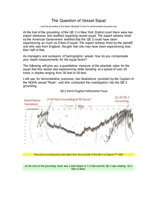
  • 1. The Question of Vessel Squat I use the grounding of the Queen Elizabeth 2 here for demonstration purposes only At the trial of the grounding of the QE 2 in New York District court there were two expert witnesses who testified regarding vessel squat. The expert witness hired by the American Government testified that the QE 2 could have been experiencing as much as 8 feet of squat. The expert witness hired by the plaintiff, and who was from England, thought that she may have been experiencing less than half of that. As managers and surveyors of hydrographic vessel, how do you compensate your depth measurements for the squat factor? The following will give you a quantitative measure of the absolute value for the squat that this vessel was experiencing while traveling at a speed of over 20 knots in depths ranging from 36 feet to 50 feet. I will use, for demonstrative purposes, two illustrations provided by the Captain of the NOAA vessel “Rude”, and who conducted the investigation into the QE 2 grounding. This echo sounding trace was taken from the sounder of the QE 2 on August 7th 1992 At the time of the grounding there was a tidal height of 1.5 feet and the QE 2 was drawing 32.4 feet of water.
  • 2. On August 7, 1992 at 21:44 hrs the sounding trace above shows that the ship came extremely close to the bottom near the NA buoy on the chart. (See attached illustration for a copy of the chart and the ships position). The 1966 NOAA measured depth at this position was 36 feet and was shown on the chart. Therefore, we have the following:  Charted depth, NOAA 1966…….36 feet  Height of tide…… 1.5 feet  Therefore water over the bottom was ……37.5 feet  The ship was drawing…… 32.4 feet  Let’s say that she cleared the bottom by…… 0.5 feet as the graph shows  Therefore her squat was……. 4.6 feet Let’s look at the depth of water she was traveling over at this time. For some length of time, 2 to 3 minutes, leading up to this near grounding she was in water of 40 feet and less. Experts know that the shallower the water and the greater the speed the more squat will be experienced. Fourteen minutes later she grazed a boulder that was described as a glacial erratic standing about 10 to 20 feet off the bottom. The depth of this boulder was measured to be 34.5 feet and the surrounding water was in excess of 40 feet with most of it being 40 to 50 feet. The ship was within the 50-foot surrounding contour, as shown on the 1939 smooth sheet. This would place the ship in water deeper than the “almost grounding” 14 minutes earlier. Let’s look at the squat numbers.  Charted depth “Rude” 1997……….. 34.5 feet (grazed)  Height of tide……….. 1.5 feet  Therefore water over the grazed site……….. 36.0 feet  The ship was drawing…….. 32.4 feet  Therefore the squat was………. 3.6 feet For the most part, and except for the odd isolated boulder, the ship was traveling in excess of 20 knots across an area that was slightly less than 50 feet in depth with isolated boulders having water over them of less than 31 feet but widely spaced. I doubt very much that boulders widely spaced could be considered shallow water as the ship would be over any one of them for such a short time and therefore would not accentuate or contribute to the squat factor.
  • 3. Please refer to this illustration for points referred to in the body of this article So what does this exercise tell us about vessel squat? In the first “near grounding” the ship had not reached her intended speed of 20 knots plus but had almost grounded with a squat of 4.6 feet. After reaching her speed of 20 knots plus and in deeper water she grounded with 3.6 feet of squat. Therefore, I believe the evidence is clear and indicates that this vessels hull squat characteristic are in the range of 3.6 to 4.6 feet when she travels across water depths of 40 to 50 feet at speeds of 20 plus knots. In deeper water squat would be less and in shallower water it would be more as shown by the amount of squat at the NA buoy. If your survey vessel had the same hull characteristics as the QE 2 and was conducting hydrographic survey depth measurements in water such as these and at speed such as these then you would be required to apply a depth measurement correction of 3.6 feet. Are you applying a squat correction and have you determined the squat characteristics of all your vessels?