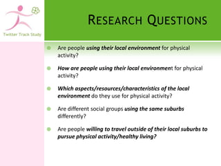
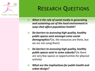
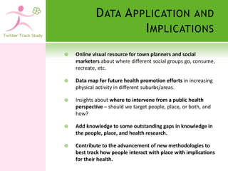
‘T WITTERING THE T ERRAIN ’: A
M IXED -M ETHODS I NVESTIGATION
INTO THE U SE OF THE L OCAL
E NVIRONMENT FOR P HYSICAL
A CTIVITY.
T HE RESEARCH TEAM

   Dr Julie-Anne Carroll - Principal Investigator

   Dr Orit Ben-Harush – Research Manager

   Dr Kristiann Heesch - Fellow Investigator

   Dr Tracy Washington – Fellow Investigator

   Dr Lynda Andrews – Fellow Investigator

   Brendan Marsh – GIS Technical/Programming
    Consultant

   Borislav Dusanic – GIS Technical/Design Consultant

   Donald Gee – Online Survey Technical Consultant
T HE F UNDING & E THICAL
                     A PPROVAL

   Women in Research Grant from QUT

   ECARD Research Project Funds


   Ethics Approval granted by QUT: 17th May 2011

   Ethics Number: 1100000449
B ACKGROUND
   Both public health and urban design research consistently
    show that people’s area of residence is an important
    determinant of their health and well-being (Day, 2008; Adams
    et al, 2010).

   However, less is known about whether it is the residential
    demographic, or the area itself, or a mixture of both that
    drives these trends in health (Leslie & Cerin, 2008; Sallis,
    2009).

   While socioeconomic demographics are said to be a leading
    determinant of geographic patterns in health (Dahmann et al,
    2010; Ball et al, 2010), it is uncertain as to what the best
    solution might be to improving both the quality of poorer
    areas, and the social responses to shared public spaces by
    poorer demographics (Schasberger, 2009; Babey et al, 2008;
    Hong & Farley, 2008).
P EOPLE , P LACE , AND P HYSICAL
A CTIVITY: ‘T HE K NOWNS ’

   Specifically, we know that:
   Socio-demographic measures of individuals are
    reliable predictors of physical activity, with richer
    people doing more of it than poorer people
    (compositional effects).

   Places of residence appear to have strong
    ‘determining’ powers in relation to physical activity
    (contextual effects).

   The socioeconomic ‘position’ of a place is a powerful
    determinant of physical activity (contextual effects).
P EOPLE , P LACE , AND P HYSICAL
A CTIVITY: T HE U NKNOWNS

   What we do NOT know is:
   Whether it is the experience and characteristics of the
    demographic, or the places themselves that are driving
    epidemiological trends in PA along geographic lines.

   Whether people who occupy more well-off neighbourhoods
    always have increased access to opportunities to be
    physically active.

   To what extent the place matters at all in terms of how
    physically active people are likely to be – ie do ‘people
    clusters’ explain health patterns?

   What the complex communication and interactive
    processes (between people and places) are that sustain
    such predictable patterns in physical activity.
L IMITATIONS W ITHIN
    C URRENT M ETHODOLOGIES

   Cross-Sectional Quantitative Analysis – allows us
    to look at whether significant relationships occur
    between demographic, geographic area, and self-
    reported behaviour.

   Multi-Level Quantitative Analysis – More
    sophisticated method that allows various
    characteristics within people and their
    environments to be measured simultaneously to
    locate more precise socio-ecological variables
    correlating with PA.
L IMITATIONS W ITHIN
     C URRENT M ETHODOLOGIES

   Current use of GIS in Health Research – Researchers
    are embracing new GIS systems, but none are tracking
    the travel paths of demographics on these maps for
    the purposes of physical activity.

   Use of ICTs in Health Research – An increasing
    number of researchers are using ICTs and social media
    to track the interactive processes that go on between
    people to generate a range of ‘population effects’

   Qualitative Work on Health and Place – Allows us to
    hear from people about how and why they interact
    with the local environment (perceptions of place), but
    does not allow us to match these perceptions with
    actual practice.
T HUS ,         THIS STUDY SEEKS TO
                                INVESTIGATE …

   How/whether people use their local environment for
    physical activity.

   Expose the interface between demographics, social media,
    geography, and physical activity.

   To geographically locate and contextualise data on physical
    activity patterns

   To generate an inventory or pathways and tracks that
    people follow in their local environment, and find out
    where they are going, and what they do there.

   By focusing on what people do in different places, and the
    social processes via which they make these decisions, we
    hope to find out how this interaction/relationship produces
    different health profiles.
R ESEARCH Q UESTIONS
   Are people using their local environment for physical
    activity?

   How are people using their local environment for physical
    activity?

   Which aspects/resources/characteristics of the local
    environment do they use for physical activity?

   Are different social groups using the same suburbs
    differently?

   Are people willing to travel outside of their local suburbs to
    pursue physical activity/healthy living?
R ESEARCH Q UESTIONS
   What is the role of social media in generating
    and sustaining use of the local environment in
    ways that affect population health?

   Do barriers to accessing high quality, healthy
    public spaces exist amongst some social
    demographics? (ie, the resources are there, but
    we are not using them)

   Do barriers to accessing high quality, healthy
    public spaces exist in some suburbs? (ie there
    are very few spaces or opportunities for physical
    activity)

   What are the implications for public health and
    urban design?
METHOD: S QUARE P EGS
            AND S QUARE H OLES

QUESTION? How do people use their local environs for PA?

Method: Use of ICTs (Twitter, Foursquare, Online Diaries) and
    GIS (Google Earth) to generate a map of where people go
    and what they do there.

QUESTION? Are there differences in these logistics/activities
   along demographic or residential lines?

Method: Quant. analysis of places visited, distances travelled,
    modes of transport, types of location and purpose of use.

QUESTION? Why do people use some places and not others?

Method: Follow-up qualitative info collected via Google maps,
    Emails, and a Facebook Page to explain pathways.
E XPECTED OUTCOME
   Quantitative Data on how different social demographics
    and different residential demographics behave and
    consume in the local environment

   Qualitative Data on the reasons for their level/degree of
    interaction with the local environment

   Spatial Data/Visual Map Display of data about how people
    perceive and interact with the local environment – an online
    resource for public health/town
    planning/marketing/business.

   Findings will be presented at a national and international
    conferences and published in peer-reviewed academic
    journals.
S TUDY L OCATION
    Two suburban case studies within Brisbane,
     Queensland, Australia

                             Bardon                     Inala
    Population                 1169                     1274
    ARIA :
                       Highly Accessible         Highly Accessible
    SEIFA                 1118.0 (high)             751.4 (low)
    Walkability Scale     ‘very walkable’     ‘somewhat walkable’


    High populations of families with children

    Assessing inherent advantages/disadvantages in relation to
     physical activity
S TUDY PARTICIPANTS

   Participants: 80 mothers primary school-aged
    children in two Brisbane suburbs, Bardon and Inala.


      Bardon & Surrounds                40


      Inala & Surrounds                 40
R ECRUITMENT

Schools’ Newsletter Ads...
E NGAGING            WITH PARTICIPANTS


   Online registration form


   Background online survey


   Choosing reporting method:
       Twitter

       Foursquare

       Online daily update
D ATA COLLECTION

   Reporting each place visited for a week
       Twitter/Foursquare mobile check-ins – real time
        reporting

       Online daily updates – once a day

   Information collected:
       Location visited (exact address + venue name)

       Transport mode

       Activity description

       Date and time

       Remarks
T WITTER
FOURSQUARE
O NLINE
FORM
D ATA RETRIEVAL
V ISUAL REPRESENTATION
F OLLOW         UP QUALITATIVE
                     DATA      (P HASE T WO )

   Email to participants with a number of
    qualitative questions , eg: What are the
    household/neighbourhood barriers to PA in your
    life?
   Table/Graph listing ‘favorite haunts’ and why
    they like it there – parks/green spaces, rec/leisure,
    extra curricular, and physical activity.
   Facebook Page interacting with participants about
    their locality:
   Facebook for Twitter Trackers
D ATA A NALYSIS – C URRENTLY
                  U NDERWAY

   Quantitative Data – obtained via Twitter,
    Foursquare, and Online Diaries and analysed in
    SPSS and Excel.


   Qualitative Data – obtained via e-questions and
    Facebook Page interactions and analysed in
    Nvivo.


   Spatial Data – obtained via table/graph and
    mapped onto GIS Google Earth.
Q UANTITATIVE D ATA
Q UALITATIVE D ATA


     Dear Twitter Track Participant,

     Thank you so much for
     completing your online diaries :-)!

     Instead of finishing the study with
     a face-to-face meeting, we would
     like to try a new method. It will
     involve 2 tasks: Answering some
     questions via email, and some
     optional activity in Facebook later
     on.
S PATIAL   DATA   - G OOGLE
                      MAPS
W HAT IS S O G OOD ABOUT
    O NLINE /S OCIAL M EDIA FOR
             D ATA C OLLECTION ?
   Less labour intensive and less time consuming

   Twitter and Foursquare give us data in ‘real time’

   Twitter and Foursquare give objective data about locations
    and use of local environment

   Twitter and Foursquare provide ‘neat’ quantitative data for
    analysis – ie, distances travelled, location type/category, as
    well as qualitative insights about the social connections
    driving people to these locations, and their opinions of the
    places.

   Email is very quick and saves time by not having to transcribe.
    Saves $$$.

   Facebook allows an open social laboratory for exploring how
    people connect/interact in their local areas.
C HALLENGES AND THE
                F OLLOW -U P S TUDY

   Mums not keen to TWITTER or FOURSQUARE –
    Gen X and Gen Y/Higher and Lower
    socioeconomic mums

   Mums OK to Facebook – hence the Twitter Track
    Facebook Page – which will help us to ‘watch’ the
    social processes that generate patterns in use of
    the local area for health.

   Gen Y student cohort coming next! – we
    anticipate a much higher level of engagement
    with Twitter and Foursquare in this next study
    about youth, place, and health.
D ATA A PPLICATION AND
                      I MPLICATIONS
   Online visual resource for town planners and social
    marketers about where different social groups go, consume,
    recreate, etc.

   Data map for future health promotion efforts in increasing
    physical activity in different suburbs/areas.

   Insights about where to intervene from a public health
    perspective – should we target people, place, or both, and
    how?

   Add knowledge to some outstanding gaps in knowledge in
    the people, place, and health research.

   Contribute to the advancement of new methodologies to
    best track how people interact with place with implications
    for their health.
T HANK YOU

Twitter track study 110628

  • 1.
    ‘T WITTERING THET ERRAIN ’: A M IXED -M ETHODS I NVESTIGATION INTO THE U SE OF THE L OCAL E NVIRONMENT FOR P HYSICAL A CTIVITY.
  • 2.
    T HE RESEARCHTEAM  Dr Julie-Anne Carroll - Principal Investigator  Dr Orit Ben-Harush – Research Manager  Dr Kristiann Heesch - Fellow Investigator  Dr Tracy Washington – Fellow Investigator  Dr Lynda Andrews – Fellow Investigator  Brendan Marsh – GIS Technical/Programming Consultant  Borislav Dusanic – GIS Technical/Design Consultant  Donald Gee – Online Survey Technical Consultant
  • 3.
    T HE FUNDING & E THICAL A PPROVAL  Women in Research Grant from QUT  ECARD Research Project Funds  Ethics Approval granted by QUT: 17th May 2011  Ethics Number: 1100000449
  • 4.
    B ACKGROUND  Both public health and urban design research consistently show that people’s area of residence is an important determinant of their health and well-being (Day, 2008; Adams et al, 2010).  However, less is known about whether it is the residential demographic, or the area itself, or a mixture of both that drives these trends in health (Leslie & Cerin, 2008; Sallis, 2009).  While socioeconomic demographics are said to be a leading determinant of geographic patterns in health (Dahmann et al, 2010; Ball et al, 2010), it is uncertain as to what the best solution might be to improving both the quality of poorer areas, and the social responses to shared public spaces by poorer demographics (Schasberger, 2009; Babey et al, 2008; Hong & Farley, 2008).
  • 5.
    P EOPLE ,P LACE , AND P HYSICAL A CTIVITY: ‘T HE K NOWNS ’  Specifically, we know that:  Socio-demographic measures of individuals are reliable predictors of physical activity, with richer people doing more of it than poorer people (compositional effects).  Places of residence appear to have strong ‘determining’ powers in relation to physical activity (contextual effects).  The socioeconomic ‘position’ of a place is a powerful determinant of physical activity (contextual effects).
  • 6.
    P EOPLE ,P LACE , AND P HYSICAL A CTIVITY: T HE U NKNOWNS  What we do NOT know is:  Whether it is the experience and characteristics of the demographic, or the places themselves that are driving epidemiological trends in PA along geographic lines.  Whether people who occupy more well-off neighbourhoods always have increased access to opportunities to be physically active.  To what extent the place matters at all in terms of how physically active people are likely to be – ie do ‘people clusters’ explain health patterns?  What the complex communication and interactive processes (between people and places) are that sustain such predictable patterns in physical activity.
  • 7.
    L IMITATIONS WITHIN C URRENT M ETHODOLOGIES  Cross-Sectional Quantitative Analysis – allows us to look at whether significant relationships occur between demographic, geographic area, and self- reported behaviour.  Multi-Level Quantitative Analysis – More sophisticated method that allows various characteristics within people and their environments to be measured simultaneously to locate more precise socio-ecological variables correlating with PA.
  • 8.
    L IMITATIONS WITHIN C URRENT M ETHODOLOGIES  Current use of GIS in Health Research – Researchers are embracing new GIS systems, but none are tracking the travel paths of demographics on these maps for the purposes of physical activity.  Use of ICTs in Health Research – An increasing number of researchers are using ICTs and social media to track the interactive processes that go on between people to generate a range of ‘population effects’  Qualitative Work on Health and Place – Allows us to hear from people about how and why they interact with the local environment (perceptions of place), but does not allow us to match these perceptions with actual practice.
  • 9.
    T HUS , THIS STUDY SEEKS TO INVESTIGATE …  How/whether people use their local environment for physical activity.  Expose the interface between demographics, social media, geography, and physical activity.  To geographically locate and contextualise data on physical activity patterns  To generate an inventory or pathways and tracks that people follow in their local environment, and find out where they are going, and what they do there.  By focusing on what people do in different places, and the social processes via which they make these decisions, we hope to find out how this interaction/relationship produces different health profiles.
  • 10.
    R ESEARCH QUESTIONS  Are people using their local environment for physical activity?  How are people using their local environment for physical activity?  Which aspects/resources/characteristics of the local environment do they use for physical activity?  Are different social groups using the same suburbs differently?  Are people willing to travel outside of their local suburbs to pursue physical activity/healthy living?
  • 11.
    R ESEARCH QUESTIONS  What is the role of social media in generating and sustaining use of the local environment in ways that affect population health?  Do barriers to accessing high quality, healthy public spaces exist amongst some social demographics? (ie, the resources are there, but we are not using them)  Do barriers to accessing high quality, healthy public spaces exist in some suburbs? (ie there are very few spaces or opportunities for physical activity)  What are the implications for public health and urban design?
  • 12.
    METHOD: S QUAREP EGS AND S QUARE H OLES QUESTION? How do people use their local environs for PA? Method: Use of ICTs (Twitter, Foursquare, Online Diaries) and GIS (Google Earth) to generate a map of where people go and what they do there. QUESTION? Are there differences in these logistics/activities along demographic or residential lines? Method: Quant. analysis of places visited, distances travelled, modes of transport, types of location and purpose of use. QUESTION? Why do people use some places and not others? Method: Follow-up qualitative info collected via Google maps, Emails, and a Facebook Page to explain pathways.
  • 13.
    E XPECTED OUTCOME  Quantitative Data on how different social demographics and different residential demographics behave and consume in the local environment  Qualitative Data on the reasons for their level/degree of interaction with the local environment  Spatial Data/Visual Map Display of data about how people perceive and interact with the local environment – an online resource for public health/town planning/marketing/business.  Findings will be presented at a national and international conferences and published in peer-reviewed academic journals.
  • 14.
    S TUDY LOCATION  Two suburban case studies within Brisbane, Queensland, Australia Bardon Inala Population 1169 1274 ARIA :  Highly Accessible Highly Accessible SEIFA 1118.0 (high) 751.4 (low) Walkability Scale ‘very walkable’ ‘somewhat walkable’  High populations of families with children  Assessing inherent advantages/disadvantages in relation to physical activity
  • 15.
    S TUDY PARTICIPANTS  Participants: 80 mothers primary school-aged children in two Brisbane suburbs, Bardon and Inala. Bardon & Surrounds 40 Inala & Surrounds 40
  • 16.
  • 17.
    E NGAGING WITH PARTICIPANTS  Online registration form  Background online survey  Choosing reporting method:  Twitter  Foursquare  Online daily update
  • 18.
    D ATA COLLECTION  Reporting each place visited for a week  Twitter/Foursquare mobile check-ins – real time reporting  Online daily updates – once a day  Information collected:  Location visited (exact address + venue name)  Transport mode  Activity description  Date and time  Remarks
  • 19.
  • 20.
  • 21.
  • 22.
  • 23.
  • 24.
    F OLLOW UP QUALITATIVE DATA (P HASE T WO )  Email to participants with a number of qualitative questions , eg: What are the household/neighbourhood barriers to PA in your life?  Table/Graph listing ‘favorite haunts’ and why they like it there – parks/green spaces, rec/leisure, extra curricular, and physical activity.  Facebook Page interacting with participants about their locality:  Facebook for Twitter Trackers
  • 25.
    D ATA ANALYSIS – C URRENTLY U NDERWAY  Quantitative Data – obtained via Twitter, Foursquare, and Online Diaries and analysed in SPSS and Excel.  Qualitative Data – obtained via e-questions and Facebook Page interactions and analysed in Nvivo.  Spatial Data – obtained via table/graph and mapped onto GIS Google Earth.
  • 26.
  • 27.
    Q UALITATIVE DATA Dear Twitter Track Participant, Thank you so much for completing your online diaries :-)! Instead of finishing the study with a face-to-face meeting, we would like to try a new method. It will involve 2 tasks: Answering some questions via email, and some optional activity in Facebook later on.
  • 28.
    S PATIAL DATA - G OOGLE MAPS
  • 29.
    W HAT ISS O G OOD ABOUT O NLINE /S OCIAL M EDIA FOR D ATA C OLLECTION ?  Less labour intensive and less time consuming  Twitter and Foursquare give us data in ‘real time’  Twitter and Foursquare give objective data about locations and use of local environment  Twitter and Foursquare provide ‘neat’ quantitative data for analysis – ie, distances travelled, location type/category, as well as qualitative insights about the social connections driving people to these locations, and their opinions of the places.  Email is very quick and saves time by not having to transcribe. Saves $$$.  Facebook allows an open social laboratory for exploring how people connect/interact in their local areas.
  • 30.
    C HALLENGES ANDTHE F OLLOW -U P S TUDY  Mums not keen to TWITTER or FOURSQUARE – Gen X and Gen Y/Higher and Lower socioeconomic mums  Mums OK to Facebook – hence the Twitter Track Facebook Page – which will help us to ‘watch’ the social processes that generate patterns in use of the local area for health.  Gen Y student cohort coming next! – we anticipate a much higher level of engagement with Twitter and Foursquare in this next study about youth, place, and health.
  • 31.
    D ATA APPLICATION AND I MPLICATIONS  Online visual resource for town planners and social marketers about where different social groups go, consume, recreate, etc.  Data map for future health promotion efforts in increasing physical activity in different suburbs/areas.  Insights about where to intervene from a public health perspective – should we target people, place, or both, and how?  Add knowledge to some outstanding gaps in knowledge in the people, place, and health research.  Contribute to the advancement of new methodologies to best track how people interact with place with implications for their health.
  • 32.