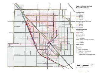
TURLOCK GENERAL PLAN
W CHRISTOFFERSEN PKWY E CHRISTOFFERSEN PKWY
WTAYLOR RD ETAYLOR RD
W MONTEVISTA AVE E MONTEVISTA AVE
ETUOLUMNE RDWTUOLUMNE RD
E HAWKEYE AVEFULKERTH RD
WEST MAIN ST EAST AVE
E LINWOOD AVEW LINWOOD AVE
SWALNUTRD
SLANDERAVE
SOUTH AVE
W CANAL DR E CANAL DR
NWALNUTRD
GEERRD
NOLIVEAVE
NBERKELEYAVE
NQUINCYRD
O
LIVE
ST
MARSHALL ST
D
ST
FIFTH
ST
N
GO
LDEN
STATE
BLVD
SGO
LDEN
STATE
BLVD
SQUINCYRD
SJOHNSONRD
NDAUBENBERGERRD
NROSEST
DELSLN
CROWELLRD
NCOLORADOAVE
E MINNESOTA AVE
NORTH AVE
NSODERQUISTRD
SKILROYRD
STEGNERRD
FRANSILLN
DIANNEDR
GOLFRD
HARDING RD
BRIER RD
99
99
SE2
SE2
SE3
SE1
SE3
MONTANA
WEST
VERDUGARD
General Plan Land Use
Diagram
0 0.5 10.25
Miles
Source: General Plan data, City of Turlock, 2002; Infill Area
data and Opportunity sites data, Dyett and Bhatia, 2012;
Map base data, City of Turlock, 2008.
Study Area Boundary
City Limits & County Islands
Master Plan Areas
Circulation 2030
General Plan
Figure 2-2
Boundaries
SE3
Very Low Density Residential
Low Density Residential
Low-Medium Density Residential
Medium Density Residential
Medium Density Residential/ Office
High Density Residential
High Density Residential/ Office
Downtown
Highway Commercial
Community Commercial
Community Commercial/ Office
Community Commercial/High
Density Residential
Heavy Commercial
Office
Business Park
Industrial
Park
Public
Urban Reserve
New or updated master plan
required before redesignated
land uses take effect
Freeway
Expressway
Potential Expressway Connection
Arterial
Collector
Railroads
Adopted September 2012
TURLOCK GENERAL PLAN
Prepared by
for the City of Turlock
Adopted September 2012
In association with
Onmi-Means, Transportation Planners and Engineers
West Yost Associates
Economic & Planning Systems
Charles Salter Associates
i | TURLOCK GENERAL PLAN
Table of Contents
1	Introduction..................................................................................................................1-1
1.1	 General Plan Themes............................................................................................... 1-2
1.2	 State and Regional Planning Context........................................................................1-5
1.3	 Scope and Purpose................................................................................................... 1-8
1.4	 Regional Location and Planning Boundaries............................................................ 1-9
1.5	 General Plan Requirements..................................................................................... 1-13
1.6	 Relationship to Other City Regulations, Policies, and Programs..............................1-14
1.7	 Planning Process.....................................................................................................1-16
1.8	 Plan Organization...................................................................................................1-17
1.9	 Plan Administration............................................................................................... 1-18
2	 Land Use and Economic Development..........................................................................2-1
2.1	 Current Land Use Pattern........................................................................................2-2
2.2	 Land Use Classifications..........................................................................................2-7
2.3	 Development Potential........................................................................................... 2-17
2.4	Downtown............................................................................................................ 2-23
2.5	 Residential Areas...................................................................................................2-28
2.6	 Retail, Commercial and Mixed Use Areas...............................................................2-31
2.7	 Industrial Areas......................................................................................................2-35
2.8	 Professional Office and Business Park Areas............................................................ 2-37
ii | TURLOCK GENERAL PLAN
2.9	 The Planning Area and City/County Relationships................................................ 2-38
2.10	Urban Reserve....................................................................................................... 2-41
2.11	 Economic Development......................................................................................... 2-43
3	 New Growth Areas and Infrastructure.......................................................................... 3-1
3.1	 Growth Strategy.......................................................................................................3-1
3.2	 Land Use and Design of New Growth Areas........................................................... 3-13
3.3	Infrastructure ....................................................................................................... 3-34
4	 Parks, Schools, and Community Facilities.....................................................................4-1
4.1	 Parks and Recreational Open Space.......................................................................... 4-1
4.2	 Community Facilities............................................................................................ 4-21
4.3	 Public Education Facilities..................................................................................... 4-32
5	Circulation................................................................................................................... 5-1
5.1	 Travel Trends........................................................................................................... 5-3
5.2	 Roadway Network, Standards, and Improvements................................................... 5-5
5.3	 Pedestrian and Bicycle Circulation..........................................................................5-25
5.4	 Public Transportation.............................................................................................5-33
5.5	 Aviation, Rail, and Goods Movement......................................................................5-41
5.6	 Electricity, Oil, Gas, and Telecommunications Transmission and Distribution....... 5-48
iii | TURLOCK GENERAL PLAN
6	 City Design..................................................................................................................6-1
6.1	 Overall City Form and Edge Conditions..................................................................6-1
6.2	 Neighborhood Form............................................................................................... 6-7
6.3	 Street Design and Connectivity.............................................................................. 6-18
6.4	 Sustainable Site Planning ......................................................................................6-23
6.5	 Art in Public Places................................................................................................6-26
6.6	 Historic Preservation..............................................................................................6-28
6.7	 Urban Design........................................................................................................6-29
7	Conservation................................................................................................................7-1
7.1	 Open Space ............................................................................................................. 7-1
7.2	 Agriculture and Soil Resources.................................................................................7-6
7.3	 Hydrology and Water Quality................................................................................ 7-17
7.4	 Biological Resources.............................................................................................. 7-17
7.5	 Cultural and Historic Resources............................................................................. 7-23
7.6	 Mineral Resources.................................................................................................7-28
8	 Air Quality and Greenhouse Gases...............................................................................8-1
8.1	 Air Quality.............................................................................................................. 8-1
8.2	 Energy and Climate Change.................................................................................. 8-23
iv | TURLOCK GENERAL PLAN
9	Noise............................................................................................................................9-1
9.1	 Noise Characteristics and Measurement................................................................... 9-1
9.2	 Noise Generation in Turlock....................................................................................9-3
9.3	 Noise Exposure Standards....................................................................................... 9-7
10	Safety......................................................................................................................... 10-1
10.1	 Hazardous Materials and Operations......................................................................10-1
10.2	Seismic and Geologic Hazards...............................................................................10-9
10.3	 Flooding and Drainage......................................................................................... 10-15
10.4	Public Safety and Emergency Management ..........................................................10-18
Appendix A: Montana-West Street Plan............................................................................. A-1
Appendix B: Capital Facilities Fee Update......................................................................... B-1
Appendix C: Projected Roadway Levels of Service.............................................................C-1
v | TURLOCK GENERAL PLAN
List of Figures
Figure 1-1:	 Regional Context............................................................................................1-10
Figure 1-2:	 Planning Areas.................................................................................................1-11
Figure 2-1:	 Existing Land Use in Turlock City Limits.........................................................2-3
Figure 2-2:	 Land Use Diagram...........................................................................................2-6
Figure 2-3:	 Proposed Master Plan Areas............................................................................2-18
Figure 3-1:	 Existing Master and Specific Plans.................................................................... 3-3
Figure 3-2:	 Projected Population Age Cohorts, Turlock (2010 and 2030)............................ 3-15
Figure 3-3:	 Illustrative Master Plan: Southeast 1.................................................................3-23
Figure 3-4:	 Illustrative Master Plan: Southeast 2...............................................................3-26
Figure 3-5:	 Illustrative Master Plan: Southeast 3............................................................... 3-29
Figure 3-6:	 Illustrative Master Plan: Montana-West...........................................................3-33
Figure 3-7:	 Existing Potable Water Infrastructure..............................................................3-41
Figure 3-8:	 Future Potable Water Infrastructure............................................................... 3-42
Figure 3-9:	 Historical and Projected Potable Water Demand.............................................3-44
Figure 3-10:	 Existing Wastewater Infrastructure................................................................3-46
Figure 3-11:	 Future Wastewater Infrastructure................................................................... 3-47
Figure 3-12:	 Historic and Projected Wastewater Flows........................................................ 3-49
Figure 3-13:	 Existing Storm Drainage Infrastructure...........................................................3-52
Figure 3-14:	 Future Storm Drainage Infrastructure.............................................................3-53
vi | TURLOCK GENERAL PLAN
Figure 4-1:	 Existing and Future Parks System.................................................................... 4-6
Figure 4-2:	 Existing Community Facilities...................................................................... 4-23
Figure 4-3:	 Educational Facilities.....................................................................................4-34
Figure 5-1:	 Diagrammatic Street Section............................................................................5-7
Figure 5-2:	 General Plan Circulation Diagram at Buildout................................................5-16
Figure 5-3:	 Existing and Proposed Bikeways..................................................................... 5-26
Figure 5-4:	 Pedestrian Priority Areas................................................................................ 5-28
Figure 5-5:	 Existing Local and Regional Transit Access.....................................................5-35
Figure 5-6:	 Railroads, Airport Facilities, and Truck Routes............................................... 5-42
Figure 6-1:	 Urban/Agricultural Edge Conditions................................................................6-4
Figure 6-2:	 Age of Housing Stock.....................................................................................6-10
Figure 6-3:	 Typical Neighborhood Center Land Uses....................................................... 6-12
Figure 6-4:	 Housing Types Matrix.....................................................................................6-13
Figure 6-5:	 Block Size and Street Connectivity for Residential Areas
	 and Neighborhood Centers........................................................................... 6-20
Figure 6-6:	 Diagramming Solar Orientation..................................................................... 6-25
Figure 6-7:	 Cul-De-Sac Connections.................................................................................6-31
Figure 6-8:	 Illustrative Development Plan for Neighborhood Center................................. 6-35
Figure 7-1:	 Crop Pattern....................................................................................................7-8
Figure 7-2:	 Farmland Classification and Conservation.......................................................7-11
vii | TURLOCK GENERAL PLAN
Figure 7-3:	 Biological Resources....................................................................................... 7-21
Figure 7-4:	 Historic Resources..........................................................................................7-26
Figure 9-1:	 Typical Sound Levels........................................................................................9-2
Figure 9-2:	 Existing Noise Contours................................................................................. 9-10
Figure 9-3:	 Future Noise Contours....................................................................................9-11
Figure 10-1:	 Active Cleanup Sites ...................................................................................... 10-5
Figure 10-2:	Regional Faults..............................................................................................10-10
Figure 10-3:	Erosion and Flooding Hazards...................................................................... 10-13
Figure 10-4:	Fire Hazards and Public Safety Services........................................................10-20
Figure 10-5:	Part 1 Crime Rate......................................................................................... 10-24
Figure A-1:	 Illustrative Street and Lot Plan for Montana-West Area....................................A-2
viii | TURLOCK GENERAL PLAN
List of Tables
Table 1–1:	 Organization of the General Plan....................................................................1-17
Table 2–1:	 Existing Land Use in the City Limits................................................................2-3
Table 2–2:	 Land Use Classifications and Density – Minimums and Maximums.................2-9
Table 2–3:	 General Plan Buildout by Land Use Designation: Residential......................... 2-21
Table 2–4:	 General Plan Buildout by Land Use Designation: Non-Residential.................2-22
Table 2–5:	 Per Capita Taxable Retail Sales, 2000 and 2008...............................................2-31
Table 2–6:	 Employment by Industry in Stanislaus County and Turlock (2007)................. 2-45
Table 2–7:	 City of Turlock Top 10 Major Employers.........................................................2-46
Table 2–8:	 Jobs to Employees Ratio and Jobs to Housing Unit Ratio................................2-47
Table 2–9:	 Summary of Employed Residents' Place of Work and Residence in 2000.........2-48
Table 3–1:	 Projected Additional Housing Need.................................................................3-6
Table 3–2:	 Residential Development Potential by Area.......................................................3-8
Table 3–3:	 Minimum and Maximum Average Densities in New Residential
	Neighborhoods...............................................................................................3-17
Table 4–1:	 Existing Parks and Recreational Open Spaces...................................................4-4
Table 4–2:	 Access and Location Characteristics by Park Type........................................... 4-10
Table 4–3:	 Park Acreage and Future Need ........................................................................4-13
Table 4–4:	 Planned Parks................................................................................................ 4-14
Table 4–5:	 Turlock Sports and Recreational Facilities Inventory and Need ......................4-24
ix | TURLOCK GENERAL PLAN
Table 4–6:	 Schools Serving the Study Area........................................................................4-35
Table 4–7:	 Projected Enrollment and School Demand.....................................................4-37
Table 5–1:	 Means of Transportation to Work..................................................................... 5-3
Table 5–2:	 Travel Time to Work........................................................................................ 5-4
Table 5–3:	 City and State Commuter Statistics.................................................................. 5-5
Table 5–4:	 Typical Street Elements and Widths (Feet): Residential Facilities....................... 5-8
Table 5–5:	 Typical Street Elements and Widths (Feet): Commercial or
	 Industrial Facilities........................................................................................... 5-8
Table 5–6:	 Intersection Spacing and Access Restrictions.....................................................5-9
Table 5–7:	 Intersection Design by Classification Type.......................................................5-10
Table 7–1:	 Components of Open Space Plan......................................................................7-5
Table 7–2:	 Farmland Classification in the Study Area.......................................................7-12
Table 7–3:	 Sensitive Biological Resources Potentially Found in the Study Area.................7-20
Table 7–4:	 Historic Resources in the Study Area.............................................................. 7-25
Table 8–1:	 State and National Criteria Air Pollutant Standards, Effects, and Sources..........8-5
Table 8–2:	 Attainment Status for Criteria Pollutant Standards, San Joaquin Valley
	 Air Basin..........................................................................................................8-7
Table 8–3:	 Current and Projected Greenhouse Gas emissions by Source...........................8-28
Table 9–1:	 Land Use Classifications and Density – Minimums and Maximums.................9-8
Table 9–2:	 Allowable Noise Exposure.............................................................................. 9-12
Table 9–3:	 Noise Level Performance Standards for Non-Transportation Sources...............9-13
Table 10–1:	 Active Cleanup Sites and Waste Facilities........................................................ 10-3
x | TURLOCK GENERAL PLAN
Table 10–2:	 Police Department Response Times...............................................................10-25
Table B-1:	 Planned Roadway Improvements......................................................................B-1
Table B-2:	 Facilities, Services, and Studies for Inclusion in CFF Update............................ B-3
Table C-1:	 Full Buildout LOS........................................................................................... C-1
Table C-2:	 LOS Thresholds............................................................................................. C-6
INTRODUCTION | 1-1
1	Introduction
Twenty years after the last comprehensive General Plan Update in 1992, it is an appropriate time
for the City of Turlock to take stock of what it has accomplished in the past two decades and lay
out a vision for its future. As a thriving community of over 70,000 in the heart of California’s
Central Valley, Turlock has held firm to its agricultural roots while diversifying economically
and expanding opportunities for its residents. It has become a very desirable community, attract-
ing many people to both live and work locally. The City’s rapid growth is expected to continue,
adding some 35,000 new residents over the next 20 years. A new General Plan is needed to guide
the City in providing critical services, amenities, infrastructure, and growth management.
Turlock has had a long history of planning. A general plan for the City was prepared in the early
1950s, and although it was never adopted, it served as a point of departure for future plans. The
General Plan prepared in 1969, much before general plans acquired their present political and
legal stature, addressed such contemporary issues as urban sprawl and unnecessary destruction of
farmland, and was updated in the early 1980s. The next General Plan (formally adopted in 1993
and partially updated in 2002) has served the City well, guiding the creation of attractive new
neighborhoods, parks, and major new retail and employment areas.
The present effort, begun in 2008, represents a continuation of this planning tradition. The
General Plan articulates a vision for Turlock that draws on the ideas of the many citizens, business
owners, and elected officials who participated in the planning process. Designed to guide growth
and development, the Plan emphasizes the creation of attractive new neighborhoods and success-
ful employment centers, while preserving the valuable farmland in which the city has its roots.
Turlock’s new General Plan reflects the changes the
city has seen over the last 20 years and presents a
vision for the next 20.
1-2 | TURLOCK GENERAL PLAN
1.1	 General Plan Themes
City Council Resolution 2009-063, passed and adopted on April 23, 2009, established the
following vision statement for the General Plan:
“Turlock will grow sensibly and compactly, maintaining its small-town feel, while enhancing
quality of life, meeting housing needs, and providing high quality jobs and recreation opportuni-
ties for its diverse population.”
Supporting this vision statement are eight General Plan Themes, which are reflected in this plan’s
elements and policies:
1.	 Establish limits to urban growth that will maintain Turlock as a freestanding city surrounded
by productive agricultural land.
The City’s identity, history, and economy derive from its site in the center of one of the richest
agricultural regions in the country. Preserving farmland and maintaining Turlock as a free-
standing community surrounded by farmland emerged as high priorities for residents. At the
same time, new neighborhoods are needed to support the city’s growing population and the
Westside Industrial Specific Plan adopted in 2002 as a 2,500-acre industrial job area. The General
Plan balances these needs by limiting the development footprint of the city, promoting infill
development, and planning for compact, mixed use neighborhoods that offer a high quality of
life to new residents and are logical extensions of the current city limits. These strategies together
can minimize conversion of prime agricultural land, one of the city’s greatest assets.
2.	Maintain an economically and socially diverse population by promoting a greater variety of
housing types citywide and a localized mix of housing types in some areas.
Numerous factors contribute to the need for Turlock to provide a wide variety of housing choices:
changing demographics, an aging population, increasingly diverse family types, and the contin-
ued high cost of housing in California. Turlock residents come from many different household
structures, circumstances, and income groups, and the General Plan calls for a more diverse
housing stock to allow opportunities for all. Elderly persons, students, single-parent households,
adults sharing housing, multifamily households and multigenerational households are household
types that evolve from economic need or personal preference. Turlock’s economically and socially
diverse population deserves a wide range of housing options.
The General Plan enables and encourages the
development of housing to suit all types of residents.
INTRODUCTION | 1-3
3.	 Attract new businesses to Turlock to create well-paying jobs and maintain a good jobs/
housing balance.
Population and economic growth in Turlock are intertwined. The city seeks to attract new indus-
tries and create jobs in order to boost revenue, remain competitive, attract new residents and
provide opportunities for existing ones. The growing resident population demands increased
goods and services which in turn fuel economic growth. The General Plan takes a multi-pronged
approach to economic development in order to achieve these goals: supporting the buildout
of the Turlock Regional Industrial Park (established by the Westside Industrial Specific Plan),
drawing new businesses Downtown, identifying new industries to target, and building on exist-
ing assets such as California State University, Stanislaus.
4.	Improve the local and regional circulation system to serve businesses and new residential
development.
In order to foster balanced, sensible growth, it is critical that land use and transportation plan-
ning proceed hand in hand. Turlock’s General Plan defines a comprehensive transportation
network, emphasizing connectivity, logical spacing, multimodal service, and “right-sizing” of
roads to match the travel demand generated by new homes and businesses in the city. Addition-
ally, the plan identifies and responds to potential regional transportation developments, such as
commuter and high speed rail, ensuring that Turlock residents can take full advantage of con-
nections to the rest of the region and beyond.
5.	 Implement sustainable development and green building principles in City projects and new
development projects. Foster development that encourages alternatives to auto use, especially
for non-commute trips.
Issues of sustainability are addressed in elements throughout the General Plan: in Land Use, City
Design, Circulation, Conservation, and more. By enabling alternatives to automobile travel and
encouraging green building construction and sustainable site design, General Plan policies help
achieve the increasingly important goals of protecting the natural environment and reducing
greenhouse gas emissions. Turlock’s level topography makes it ideal for pedestrians and bicy-
clists. However, many destinations, such as shops, services, parks, and schools, are difficult or
Complete, mixed use neighborhoods place residences
closer to jobs, stores, and services; reduce long car
trips; and create vibrant communities.
1-4 | TURLOCK GENERAL PLAN
inconvenient to access from existing neighborhoods without a car. General Plan policies counter
these trends by calling for the renewed use of traditional neighborhood street patterns and more
provisions for bicycle use, including extension of the bicycle route system throughout the whole
city. Related policies call for mixed use neighborhood centers, where services and amenities are
easily accessible.
6.	Revitalize and enhance older areas of Turlock. Create an economic and social balance among
different city sectors. Enhance the County islands within the City limits, and annex them into
the City if feasible.
While the General Plan expects Turlock’s growing population to require the development of new
neighborhoods outside current city limits, it is an equal priority for current residents to maintain
and improve Turlock’s older neighborhoods and the Downtown. Numerous infill sites—includ-
ing those in currently unincorporated County Islands—spread throughout the city’s existing
urban fabric offer opportunities to enhance the streetscape, raise property values, improve public
services, and add housing and jobs close to where current residents live. Public realm improve-
ments also help reduce crime and raise residents’ quality of life, bringing greater socioeconomic
balance to Turlock’s various neighborhoods. Promoting infill development will also improve the
economic viability of Downtown by increasing the number of residents who can walk there to
enjoy central Turlock’s historic charm and small-town ambiance.
7.	Manage growth using the Master Planning process to implement General Plan policies and
enhance Turlock’s quality of life.
Growth management has been a key component of planning in Turlock since the early 1990s.
The City’s proactive approach to master planning, phasing, and service and infrastructure pro-
vision to new development areas has distinguished it amongst Central Valley cities. The General
Plan continues this planning tradition and strengthens it with a New Growth Areas and Infra-
structure Element, which supports the City’s area-wide planning, prezoning, and annexation
policies. New master plan development areas are defined, with minimum and maximum densi-
ties, and the phasing of growth is established. This ensures that city services, public investment,
and infrastructure can keep pace with development while still maintaining high standards for
the existing urban area.
Downtown Turlock is the city’s heart, with a unique
character and sense of place. The General Plan in-
cludes policies to continue strengthening Downtown
and other older neighborhoods.
INTRODUCTION | 1-5
8.	 Provide a wide variety of recreation and cultural activities for all ages.
A key component of the General Plan is the enhancement of Turlock’s park system and network
of community and cultural facilities. While the City has built successful new parks in recent
years, including popular sports facilities, the amount of projected population growth necessi-
tates a new community park to serve the southeastern area of town. Turlock’s existing parks will
also be augmented by a system of multiuse linear parks and trails, linking new housing to neigh-
borhood schools, parks, and shopping centers, providing space for walking/jogging for health
and time with neighbors, and serving additional purposes of storm drainage and agricultural
buffering.
1.2	 State and Regional Planning Context
Turlock’s new General Plan comes at a time when issues of sustainability, global climate change,
and smart growth are being actively addressed at the State and regional levels. New legislation
and regional planning efforts have framed this update to Turlock’s General Plan in new and
innovative ways, and underscore the way in which each California community plays its part in
confronting these larger challenges.
California’s Greenhouse Gas Emissions Legislation
California Global Warming Solutions Act of 2006 (AB 32)
The California Global Warming Solutions Act of 2006 (Chapter 488, Statutes of 2006, also
known as Assembly Bill (AB) 32) directed the California Air Resources Board (CARB) to
perform numerous tasks aimed at achieving the state’s reduction targets, including approving
a statewide greenhouse gas (GHG) emissions estimate that is equivalent to the 1990 GHG
emissions level to be achieved by 2020. As the roadmap for achieving AB 32’s reduction goals, the
CARB Scoping Plan outlined the combination of policies, programs, and measures necessary to
reduce statewide GHG emissions to 1990 levels by 2020, the equivalent of reducing emissions by
15 percent below current levels and 30 percent below projected business-as-usual levels in 2020.
Many of the measures would, when implemented, contribute to emission reductions statewide as
well as in local communities. CARB continues to adopt measures outlined in the Scoping Plan
New park and recreation facilities will augment Tur-
lock’s existing network of parks and open space.
1-6 | TURLOCK GENERAL PLAN
and is in the process of preparing rules to implement these measures. Turlock’s General Plan
responds to CARB’s implementation strategy as it pertains to cities’ general planning efforts.
Sustainable Communities and Climate Protection Act of 2008 (SB 375)
The Sustainable Communities and Climate Protection Act of 2008 (Chapter 728, Statutes of
2008, also known as Senate Bill (SB) 375) promotes better integration of transportation and land
use planning throughout California. The statute was intended to complement efforts under
AB 32 by requiring CARB to develop regional GHG emission reduction targets for passenger
vehicles. CARB was tasked with establishing targets for the years 2020 and 2035 for each region
covered by the state’s 18 federally-designated metropolitan planning organizations (MPOs),
which in turn would be required to meet that target by considering the impacts of land use and
transportation on GHG emissions. CARB adopted regional GHG emission reduction targets for
cars and light trucks on September 23, 2010.
Pursuant to SB 375, each of California’s MPOs must prepare a Sustainable Communities
Strategy outlining how the region will meet its GHG reduction target by integrating land use
planning, transportation planning and funding, and housing needs. The SCS will be incorpo-
rated into the regional transportation plan, typically prepared by each MPO every 4 to 5 years.
CARB is required to review each SCS to determine whether it would achieve the necessary
GHG emission reduction for each region. SB 375 sets new requirements for coordinating the
RTP process with the regional housing needs allocation and housing element update processes,
and also provides incentives for implementation by establishing new California Environmental
Quality Act streamlining opportunities. The Stanislaus Council of Governments, the MPO to
which Turlock belongs, is responsible for developing an SCS pursuant to SB 375.
California Environmental Quality Act and Guidelines Amendments
Senate Bill 97 (Chapter 185, Statues of 2007) amends the California Environmental Quality
Act statute to say GHG emissions and the effects of GHG emissions are appropriately analyzed
under CEQA. Pursuant to SB 97, the Governor’s Office of Planning and Research prepared
amendments to the CEQA Guidelines in a public process, and the California Natural Resources
Agency adopted the proposed amendments in December 2009. The amendments became
effective March 18, 2010.
INTRODUCTION | 1-7
California Complete Streets Act (AB 1358)
This act requires all cities and counties to plan for the development of multimodal transportation
networks in their general plans, beginning in January 2011. “Complete Streets” meet the travel
needs of all users of streets, roads, and highways, and of all modes of travel (walking, cycling,
driving, etc.). Turlock’s General Plan responds directly to the Complete Streets Act in its Circu-
lation Element, Chapter 5.
Regional Efforts
San Joaquin Valley Blueprint and Smart Valley Places Partnership
Communities in California’s San Joaquin Valley have been engaged in an eight-county planning
process known as the San Joaquin Valley Blueprint since 2005. The Blueprint is a regional
planning process aimed at engaging communities in the region in developing a shared vision
for land use and transportation that will guide growth in the area over the next 50 years. The
“Blueprint Roadmap Summary Final Report” was released in September 2010. It describes the
Preferred Scenario and 12 Smart Growth Principles adopted by the Regional Policy Council that
resulted from the process, and it outlines steps for implementation.
As a partner city in the Valley Blueprint process, Turlock is also participating in the Smart Valley
Places Partnership, a formal network of cities, agencies, institutions, and nongovernmental orga-
nizations with the goal of implementing a regional plan for sustainable development in the San
Joaquin Valley. With the assistance of a Sustainable Communities Planning Grant from the U.S.
Department of Housing and Urban Development, the partnership is continuing the work of
the Blueprint with the development of a shared Regional Sustainability Toolbox and individual
cities’ projects and plans.
The Smart Valley Places Partnership adopted the HUD-EPA-DOT Livability Principles, which
Turlock’s General Plan also reflects through its themes and policies. The Principles are:
•	 Provide more transportation choices;
•	 Promote equitable, affordable housing;
•	 Enhance economic competitiveness;
Planning for the needs of pedestrians, cyclists, and
other transportation modes helps meet State require-
ments for greenhouse gas reductions and “Complete
Streets.”
1-8 | TURLOCK GENERAL PLAN
•	 Support existing communities;
•	 Coordinate and leverage policies and investment; and
•	 Value communities and neighborhoods.
Turlock’s involvement in these and future regional planning processes will ensure that the city’s
interests are represented in the region and will contribute positively to creating a consistent and
feasible strategy for regional growth.
1.3	 Scope and Purpose
The General Plan governs all City actions relating to Turlock’s growth and development. It
is both a long-range vision and a guide to ongoing decision-making and near-term actions. It
expresses the general ideas and desires of the community; the seven themes described above
together convey a sense of what is most important to the City’s residents and how the community
will focus its efforts in dealing with change during the coming decades. The defined policies,
maps, standards, and guidelines outline what actions must be implemented in order to accom-
modate population and employment growth over a 20-year time period. Guiding policies in each
chapter are statements of vision and overall intent.
However, the Plan will be in use long before the City’s vision is achieved. The Plan is a document
for landowners and developers to consult prior to formulating development proposals, and for
City officials to consult when reviewing proposals for private development and public projects.
As a guide to the City’s physical development, the Plan offers criteria for evaluating the consis-
tency and desirability of development proposals, and it also sets forth actions to be undertaken by
the City. These range from public works projects to revisions of the Zoning Ordinance. Because
of the requirements that a variety of other City actions be consistent with the General Plan,
regular ongoing use of the Plan is essential. Additionally, the General Plan can help guide shorter
term strategic and financial planning for the City. As each City Council engages in visioning for
the future, the shorter-term strategic plans should be consistent with and reflect the overall long-
range goals of the General Plan.
INTRODUCTION | 1-9
1.4	 Regional Location and Planning
Boundaries
Regional Location
The City of Turlock is located in Stanislaus County, on the eastern side of California’s San
Joaquin Valley, 100 miles east of the San Francisco Bay Area. The City is on the State Highway 99
corridor, linking it to other Central Valley cities including Stockton and Sacramento to the north
and Fresno and Bakersfield to the south. Turlock remains a stand-alone city surrounded by pro-
ductive agricultural land. Figure 1-1 shows Turlock in its regional Northern California context.
Turlock’s largest neighbor is the City of Modesto, which lies 14 miles north. The communities of
Keyes, Denair, and Ceres are the closest neighboring communities to the north; Delhi, Hilmar,
and Livingston are located within 10 miles to the south. Twenty miles to the west and southwest,
Patterson and Newman are along the I-5 corridor. This collection of communities represents
the area in which most Turlock residents work, as well as the area from which people come to
Turlock for employment and shopping.
Planning Boundaries
Planning Area
The Planning Area is the geographic area for which the General Plan establishes policies about
future urban growth, long-term agricultural activity, and natural resource conservation. The
boundary of the Planning Area was determined in response to State law requiring each city to
include in its General Plan all territory within the boundaries of the incorporated area as well as
“any land outside its boundaries which in the planning agency’s judgment bears relation to its
planning” (California Government Code Section 65300).
The Planning Area, shown in Figure 1-2, extends beyond Turlock’s city limits and includes the
unincorporated communities of Keyes and Denair. They have been included because the City
believes these unincorporated communities and lands bear relation to planning activities the
City undertakes, and in some cases, benefit from City services. For example, Turlock provides
wastewater treatment services to Keyes and Denair. However, the City recognizes Stanislaus
County’s role in land use planning for these unincorporated but urbanized areas. The extension
1-10 | TURLOCK GENERAL PLAN
41
San
Francisco
Oakland
Berkeley
South
San
Francisco
Pacifica
Half
Moon
Bay
San
Jose
Santa
Clara
Daly
City
Sunnyvale
Palo
Alto
San
Mateo
Burlingame
Fremont
Hayward
San
Leandro
Castro
Valley
Pleasanton Livermore
San
Ramon
Redwood
City
Walnut
Creek
ConcordPleasant
Hill
Richmond
San
Rafael
Novato
Mill
Valley
Vallejo
Benicia
Martinez
Pittsburg
AntiochSan
Anselmo
Petaluma
Rohnert
Park
Cotati
Santa
Rosa
Sonoma Napa
St Helena
Calistoga
Fairfield
Vacaville
Dixon
Davis
Winters
Woodland
Sacramento
Galt
Lodi
Stockton
Rio
Vista
Brentwood
Folsom
Citrus
Heights
Manteca
Tracy
Modesto
Oakdale
Escalon
Patterson
Morgan
Hill
Gilroy
Santa
Cruz
Scotts
Valley
Watsonville
Hollister
Prunedale
Aromas
Salinas
Los
Banos
Dos
Palos
Gustine
Newman
Hillmar
Merced
Atwater
Livingston
Turlock
Riverbank
Waterford
Chowchilla
Fresno
Firebaugh
Mendota
Kerman
Madera
Clovis
Sanger
Denair
Oakhurst
Angels
Camp
Sonora
Mono
Vista
Jackson
Ione
Rancho
Calaveras
Rancho
Murrieta
Elk
Grove
Rancho
Cordova
Cameron
Park
Lafayette
El
Sobrante
Mariposa
E L D O R A D O
A M A D O R
S A C R A M E N T O
S A N
J O A Q U I N
C A L A V E R A S
T U O L U M N E
S T A N I S L A U SA L A M E D A
C O N T R A
C O S T A
S A N T A
C L A R A
S A N T A
C R U Z
S A N
M A T E O
M A R I N
S O N O M A
N A P A S O L A N O
Y O L O
S A N
B E N I T OM O N T E R E Y
M E R C E D
M A D E R A
F R E S N O
M A R I P O S A
Y O S E M I T E
N A T I O N A L
P A R K
Henry
Coe S.P.
Henry
Cowell
S.P.
Big
Basin
S.P.
Castle
Rock S.P.
Mt. Diablo
S.P.
Los Banos
Waterfowl
Mgt. Area
Great Valley
Grasslands S.P.
S
a
n
J
o
aq
u
i
n
R
iver
S
a n J o a q u i n
R i v e r
M e r c e d
R i v e
r
T u o l u m
n e R i v e r
S t a n i s l a u
s
R
iv
e r
F
r
e
sn
o
R
ive
r
C a l av e
r a s R i v e r
M o k e l um n e
R i ver
S
acram e n t o
R
iv
er
San
Luis
Reservoir
Turlock
Lake
Lake
McClure
Don
Pedro
Reservoir
Modesto
Reservoir
Woodward
Reservoir
Eastman
Lake
Hensley
Lake
Millerton
Lake
Anderson
Lake
Calaveras
Reservoir
San
Francisco
Bay
P a c i f i c
O c e a n
Monterey
Bay
San
Pablo
Bay
Lake
Berryessa
Cherry
Lake
Hetch Hetchy
Reservoir
Bass
Lake
Burns
Reservoir
Yosemite
Lake
Farmington
Flood Control
Basin
New
Hogan
Lake
Commanche
Reservoir
Pardee
Res
Mariposa
Reservoir
Del Valle
Reservoir
Salt Spring
Valley
Reservoir
180
41
99
33
145
145
33
152
165 159
152
25
129
1
1
1
17
1
85
92
4
33
132132
4
4
242
12
12
12 4
120
120
108
49
49
88
16
49
88
88
26
160
113
37
12
12 29
121
128
128
113
99
99
49
140
140
120
140
120
80
680
780
680
80
580
880
580
5
101
101
101
101
280
680
101
5
205
5
50
505
80
Major Highways
Other Highways
Urbanized Areas
Counties
National/State Parks
National Forest
Water Bodies
Figure 1-1
Draft General Plan
Regional Context
0 10 20
MILES
5
Figure 1-1:	 Regional
Context
INTRODUCTION | 1-11
W CHRISTOFFERSEN PKWY E CHRISTOFFERSEN PKWY
WTAYLOR RD ETAYLOR RD
W MONTEVISTA AVE E MONTEVISTA AVE
ETUOLUMNE RDWTUOLUMNE RD
E HAWKEYE AVEFULKERTH RD
WEST MAIN ST EAST AVE
E LINWOOD AVEW LINWOOD AVE
SWALNUTRD
SLANDERAVE
SOUTH AVE
E CANAL DR
NWALNUTRD
GEERRD
NOLIVEAVE
NBERKELEYAVE
NQUINCYRD
E
M
AIN
ST
MARSHALL ST
D
ST
FIFTH
ST
N
G
O
LD
EN
STATE
BLVD
SGO
LDEN
STATE
BLVD
SQUINCYRD
SJOHNSONRD
NDAUBENBERGERRD
SFAITHHOMERD
DELSLN
NCOLORADOAVE
E MINNESOTA AVE
NORTH AVENSODERQUISTRD
SKILROYRD
STEGNERRD
FRANSILLN
DIANNEDR
GOLFRD
HARDING RD
¥¥
99
¥¥
99
MOUNTAINVIEWRD
E GREYSON RD
STANISLAUS COUNTY
Planning Areas
0 0.75 1.50.375
Miles
Source: City of Turlock, 2011; Dyett and Bhatia, 2011;
Planning Boundary
Study Area Boundary
Existing Sphere of Influence
County Line
City Limits & County Islands
Draft General Plan
Figure 1-2
Freeway
Roads
Railroads
KEYES
DENAIR
MERCED
COUNTY
Figure 1-2:	 Planning Areas
1-12 | TURLOCK GENERAL PLAN
of the Planning Area to these communities underscores the importance of interjurisdictional
cooperation and planning in key areas. The Planning Area occupies 29,800 acres or 46.5 square
miles.
Study Area
The Study Area represents the greatest extent to which Turlock’s urban development may take
place over the next 20 years. Only land within the Study Area has been assigned urban uses or
designated as Urban Reserve. Urban Reserve is land that would likely be developed in the next
20 to 50 years—beyond the scope of this General Plan, but may be considered for possible longer
term development. The Urban Reserve includes land for future urban neighborhood develop-
ment, future jobs west of Highway 99, regional shopping centers, and a greenbelt surrounding
the city to the maximum extent possible.
The majority of existing conditions research, analysis, and policy formulation pertains only to
the Study Area, and this is the area that is depicted on the Land Use Diagram and other support-
ing maps in the General Plan. The Study Area is roughly bounded by Taylor Road to the north,
Waring and Verduga roads to the east, Harding Road to the south, and Commons and Wash-
ington roads to the west. It also includes some additional land at the northwest corner, along the
State Route 99 Corridor, encompassing the Taylor Road interchange. The Study Area comprises
17,460 acres or 27 square miles.
Sphere of Influence
The General Plan must cover Turlock’s adopted Sphere of Influence (SOI) as well as any land
outside of it that is relevant to the city’s planning. The SOI is a boundary that encompasses
lands that are expected to ultimately be annexed by the City, and it will be updated to match the
extent of planned urban development as part of the General Plan Update. The SOI is determined
by the Stanislaus County Local Agency Formation Commission (LAFCO), which is an entity
empowered to review and approve proposed boundary changes and annexations by incorporated
municipalities. Portions of the Planning Area beyond the SOI may or may not be annexed to
Turlock, but are still considered to be related to and influenced by the City’s planning.
INTRODUCTION | 1-13
1.5	 General Plan Requirements
California’s tradition of allowing local authority over land use decisions means that the State’s
cities have considerable flexibility in preparing their General Plans. However, though land use
policies are not mandated, the issues to be addressed in the Plan are prescribed by State law. Cali-
fornia Government Code Sections 65300 et seq. establish requirements for the content of General
Plans, as well as for their adoption and subsequent amendments.
General Plan Elements
Seven general plan elements are required by State law, which permits the required contents
of the elements to be combined at the discretion of the local government producing the Plan.
The seven required elements are: Land Use, Circulation, Housing, Open Space, Conservation,
Noise, and Safety. Section 1.8 describes how this plan meets State requirements and how the
material required to be in these elements is organized and integrated with optional elements
in the Turlock General Plan. The Housing Element is the part of the Plan for which the most
detailed and extensive requirements are prescribed. Because the Housing Element is required by
State law to be updated at specific times—more frequently than the rest of the General Plan—it
is published as a separate document. However, the Housing Element is written to be consistent
with the rest of the General Plan.
COMPREHENSIVENESS
The General Plan must be comprehensive. This requirement has two components. First is a geo-
graphic component, which requires that the Plan cover the entire incorporated area of the City,
as well as any other land which bears relation to the City’s planning. Figure 1-2 illustrates the
planning boundaries. Second, the Plan must address the full range of issues associated with the
City’s physical development.
INTERNAL CONSISTENCY
The consistency requirement established by State law (Government Code Section 65300.5) and
interpreted in several significant judicial decisions requires the separate parts of the Plan to be
fully integrated and to relate internally without conflict. This horizontal consistency requirement
extends to the diagram and figures, as well as to text, data, and analysis in addition to policies.
Residents weighed in on all aspects of the General
Plan through a series of workshops , open houses, and
focus group meetings.
1-14 | TURLOCK GENERAL PLAN
All portions of the Plan, whether required by the State or included at the option of local govern-
ment, have equal legal weight. None may supersede another. Furthermore, if a single element of
the General Plan is judged to be inadequate with respect to legal requirements, the entire Plan
may be considered inadequate. Comprehensive General Plan revisions provide an ideal opportu-
nity to satisfy the requirements of both comprehensiveness and consistency.
1.6	 Relationship to Other City Regulations,
Policies, and Programs
The General Plan provides the basis for all of the City’s regulations, policies and programs that
relate to issues addressed in the Plan. In addition to requiring that the Plan be internally consis-
tent, the State requires what is sometimes called vertical consistency — i.e., consistency between
the General Plan and other City actions. This requirement means that the City’s zoning and sub-
division ordinances, specific plans and redevelopment plans, all development approvals, public
works projects, and open space implementation programs have to be consistent with the General
Plan.
The State’s General Plan Guidelines provides the following rule for defining consistency: “An
action, program, or project is consistent with the general plan if, considering all its aspects, it will
further the objectives and policies of the general plan and not obstruct their attainment.” This
rule clarifies that consistency does not require all subsequent city actions to be specifically antic-
ipated by the General Plan. Because the Plan is both general and long-range, there are many
circumstances where future City actions will be addressed only generally in the Plan.
CONSISTENCY BETWEEN THE PLAN AND ZONING
The City’s Zoning Ordinance is one of the most important tools for implementing the Plan.
Requirements for consistency between the General Plan and zoning can be broken down into
three aspects:
•	 Uses and Standards. The General Plan’s land use classifications are more general than the
Zoning Ordinance classifications. For example, the Plan has four different categories for residen-
tial use, while the zoning ordinance may have more. Multiple zoning districts may be consistent
INTRODUCTION | 1-15
with a single General Plan residential classification, as long as all of the densities and unit types
allowed in each zoning district are also permitted in the relevant General Plan category.
•	 Spatial Correlation. The Zoning Map should reflect the general pattern of land use depicted on
the Plan Diagram. However, the two need not be identical. Boundaries of land use classifica-
tions depicted on the General Plan Diagram are typically more precise in developed areas and
more generalized in undeveloped properties. In particular, future master plan areas are given a
single General Plan land use designation with overall density requirements; precise master or
specific planning and pre-zoning is required prior to annexation. Following the adoption of a
master or specific plan, establishment of zoning, and annexation, the General Plan must then be
updated.
•	 Timing. There are two main issues related to timing. The first addresses the time frame for
bringing zoning into compliance with the General Plan; State law allows a “reasonable time”
for reconciling the zoning ordinance with the General Plan. The General Plan has a 20-year
horizon, while zoning focuses on the immediate appropriate uses for individual sites. In many
cases, zoning will only gradually fulfill the prescriptions of the General Plan, particularly as it
pertains to new growth areas, which are expected to be master planned, pre-zoned and brought
into the city in phases over a number of years.
The second issue relates to the timing and sequencing of development. All land within City
limits should be zoned in accordance with the General Plan land use designations. In instances
where land outside the City is designated for non-agricultural uses on the General Plan Diagram,
the designated General Plan uses can be applied for at the time of annexation using master plan-
ning, specific plans, and prezoning, as is currently the practice in Turlock.
Many General Plan policies, in particular those in the Land Use and Economic Develop-
ment, Housing, and City Design elements, call for specific changes to be made to the Zoning
Ordinance.
1-16 | TURLOCK GENERAL PLAN
1.7	 Planning Process
Because the General Plan is intended to be a statement of community preferences, and because
it will result in significant changes to the City, public participation in making the Plan is very
important. Broad outreach and news coverage, including a newsletter, continually-updated
project website, and press releases published prior to the first workshop, served to offer education
to the City’s citizens early in the Plan Update process. Additionally, interviews were held with
approximately 40 community leaders (elected officials, City staff, leaders of local organizations,
and other members of the planning and development community) in order to identify specific
technical issues that the Plan would need to address.
During General Plan preparation, community participation was solicited at a number of well-
attended workshops. The first focused on visioning and issue identification, the second on land
use alternatives, and the third on proposed new plan policies, held in an open-house format. In
each case, written and graphic material was prepared in advance and made available to partici-
pants. A City mailing list was maintained and used to advertise the workshops; these were also
announced on the project website. Other forums for public comment on the Plan have been City
Planning Commission and City Council meetings at which staff has provided updates on the
progress of the Plan.
Groups with special interests have also contributed. The Housing Element was prepared sep-
arately from the rest of the Plan, in order to comply with State requirements. Preparation of
this element involved two public forums held specifically for groups associated with affordable
housing in the City. Two focus groups were held for property owners whose land was likely to
be redesignated in the new General Plan, and additional meetings were held with the Turlock
Chamber of Commerce, the Downtown Property Owners Association, and other economic
groups regarding economic development strategies.
The final stages of public participation were the hearings, at which the Environmental Impact
Report that analyzes the Plan and the General Plan was certified and adopted, respectively.
Following a public open house on the plan and Final EIR in June 2012, the Planning Commis-
sion and City Council held two public hearings during the formal Plan Consideration process.
Final adoption of the updated General Plan took place on September 25, 2012.
The General Plan is a reflection of the Turlock com-
munity’s vision for the future of their cities. Residents
participated in a variety of ways throughout the
process.
INTRODUCTION | 1-17
1.8	 Plan Organization
The organization of the General Plan is summarized in Table 1-1. Throughout the Plan, cross-ref-
erences guide the reader to related policies in other sections and elements. A Financing Plan and
Capital Facility Fee Nexus Study will also accompany the General Plan.
Table 1–1:	 Organization of the General Plan
General Plan Element State-Mandated? Major Issues Addressed Closely Related Elements
Land Use and Eco-
nomic Development
Yes (Land Use);
No (Economic
Development)
Distribution of land uses, standards for density and intensity,
growth management, intergovernmental relations, jobs and em-
ployment growth, economic strategies
All
New Growth Areas
and Infrastructure
No Overall growth management strategy, phasing and design of
new neighborhoods, utility infrastructure
All
Parks, Schools, and
Community Facilities
Yes (Open Space) Parks, schools, libraries, recreational facilities Land Use, New Growth Areas, Conserva-
tion
Circulation Yes Street classifications, transit service, pedestrian and bicycle
needs, rail, air, truck routes
Land Use, New Growth Areas
City Design No City form, residential neighborhoods, public space, Downtown Land Use, Housing, Circulation
Conservation Yes1
Agriculture and soils, biological resources, water quality and hy-
drology, cultural resources, mineral resources, waste manage-
ment
Land Use, Air Quality and Greenhouse Gas-
es, Public Facilities and Services
Air Quality and Green-
house Gases
Yes2
Air quality, climate change, energy use Land Use, Transportation, Conservation
and Environmental Protection
Noise Yes Noise attenuation and reduction Land Use, Circulation
Safety Yes Seismic safety, emergency preparedness, hazardous sites and
materials, police and fire services
Land Use
Housing Yes Production and conservation of housing for low income house-
holds and households with special needs
Land Use, City Design
1.	Combines two required elements: Open Space and Conservation.
2.	General Plans for cities and counties in the San Joaquin Valley must address air quality per Assembly Bill (AB) 170. Greenhouse gases must be analyzed per AB 32.
1-18 | TURLOCK GENERAL PLAN
The General Plan Land Use Diagram found in Chapter 2 (Land Use and Economic Develop-
ment) illustrates a number of policies relating to land use, circulation, conservation, and public
facilities. The Land Use Diagram is an important part of the plan that contains information not
presented anywhere else. However, General Plan policies cannot be interpreted from the Diagram
alone. Policies throughout the Plan complement the information in the Diagram. Other maps
and diagrams illustrating existing conditions and desired planning outcomes are found through-
out other chapters in the Plan as well.
Each section of the Plan includes narrative text providing information about the topics addressed,
followed by two sets of policies:
•	 Guiding Policies are statements of philosophy or intent;
•	 Implementing Policies are commitments to specific actions that are to be undertaken in order to
achieve the results called for by the Guiding Policies.
Many policy statements are followed by explanatory text, additional descriptive information, or
cross-references, which are in italic type. The General Plan Land Use Diagram, other figures, and
the Land Use Classifications in Section 2.2 are also adopted parts of the General Plan.
1.9	 Plan Administration
The General Plan is intended to be a dynamic document. As such, it may need to be updated over
time to address site-specific or comprehensive needs, to respond to new State or federal law, or to
modify policies that may become obsolete or unrealistic over time.
AMENDMENTS TO THE PLAN
The Plan may be amended from time to time, but opportunities for such amendments are limited
to four times per year. Each amendment may make an unlimited number of changes to the Plan.
However, this restriction does not apply to optional elements (such as Community Design), to
amendments needed to comply with a court decision, or to allow for the development of afford-
able housing. Because the requirement for internal consistency is never relaxed, particular care
must be taken to ensure that amendments maintain consistency with text and diagrams in all
Plan elements.
INTRODUCTION | 1-19
Annual Report
The California Government Code requires that City staff submit an annual report to the City
Council on the status of the General Plan and progress in its implementation. This report is
submitted to the Governor’s Office on Planning and Research and the Department of Housing
and Community Development. The report must include an analysis of the progress made in
meeting the City’s share of regional housing needs (identified in the Housing Element) and local
efforts to remove governmental constraints to the maintenance, improvement, and development
of affordable housing. Also, any mitigation monitoring and reporting requirements prescribed in
the General Plan Environmental Impact Report (EIR) should be included in the annual report.
Finally, the report should also include a summary of all General Plan amendments adopted
during the preceding year, a description of upcoming projects or issues to be addressed in the
coming year, and a work program and budget.
1-20 | TURLOCK GENERAL PLAN
This page intentionally left blank.
LAND USE AND ECONOMIC DEVELOPMENT | 2-1
2	Land Use and Economic Development
The way in which a City allocates its land to meet the needs of residents and businesses is central
to the General Plan. In order to accommodate a growing, changing population and increasingly
diversifying employment, Turlock must meet the needs of these groups and uses while still main-
taining the aspects of the built environment that current citizens value: a compact city with a
small-town feel.
Chapter 2, the Land Use and Economic Development Element, begins by describing the City’s
existing land use pattern, and then describes land use classifications and the City’s develop-
ment potential. Policies and a land use plan, referred to as the General Plan Land Use Diagram,
designate the proposed general location and extent of each use category. The Element also
includes policies to manage growth and inter-jurisdictional relationships. The following chapter,
Chapter 3: New Growth Areas and Infrastructure, focuses on detailed standards for land use,
design, infrastructure, and development phasing in the areas for new urban development. Issues
related to city form, design, and character are addressed in Chapter 6: City Design.
The General Plan Land Use Diagram and the land use policies will have a major impact on
Turlock’s form and character over the life of the General Plan. Critical issues faced by Turlock
that are addressed in this Element include: direction of urban expansion and phasing of growth,
location of retail and neighborhood centers, revitalization of downtown, and location of proposed
parks and recreational facilities. The General Plan Land Use Diagram is a graphic representation
of the planning values and ideals of the community as expressed throughout the Plan. General
Plan text should be read in conjunction with the Land Use Diagram.
Land use decisions affect residents and business
interests alike.
2-2 | TURLOCK GENERAL PLAN
2.1	 Current Land Use Pattern
Overview
Turlock’s current land use pattern and built form are products of the City’s historical growth
within an agricultural area. Turlock was incorporated in 1908. Like many San Joaquin Valley
towns from the time period, the original downtown core was focused around the railroad station,
with streets arranged in a grid oriented to the tracks. The town proceeded to grow outward,
shifting to an orthogonal north-south grid matching the rural road and parcel pattern around it.
Golden State Boulevard, paralleling the railroad, was part of the original highway through the
Central Valley, which became U.S. 99 roadway in 1926.
The city’s growth since the 1940s has mainly occurred north of the downtown area and east of
the railroad. When the California State University, Stanislaus campus opened in 1965, it was still
well to the north of town. By the end of the 1980s housing boom, Turlock had reached Zeering
Road on the north and Daubenberger Road on the east. Completion in 1973 of the Route 99
freeway bypass, a long arc to the west, also drew development west of the railroad.
Beginning in the 1990s, Turlock’s growth occurred through a master planning process, one area
at a time. Almost all the recent residential development has occurred north of Monte Vista Avenue
on the east side of the railroad. The “Northwest Triangle,” north of Fulkerth Road between the
railroad and Highway 99, has also grown to be a major new commercial area.
It is the City’s goal to continue to provide a balance of jobs and housing in Turlock, which
stimulates the local economy, reduces commuting, and maintains Turlock’s competitiveness in
the region. Therefore, the master planning process has extended to the non-residential sector, as
well. In 2006, Turlock completed the Westside Industrial Specific Plan (WISP), which identi-
fied land use, transportation improvements, infrastructure improvements, and design guidelines
for industrial and business park uses for some 2,500 acres west of Route 99. Aided by this specific
plan, the city’s industrial sector is expanding and shifting to this area.
Land Use Distribution and Magnitude
There are approximately 8,730 acres in the current city limits (not including the County islands),
and an additional 8,560 acres of land are contained within the Study Area outside of city limits.
Figure 2-1 and Table 2-1 show the breakdown of existing land uses in the city limits, and each
LAND USE AND ECONOMIC DEVELOPMENT | 2-3
Figure 2-1:	 Existing Land Use in Turlock City Limits
Table 2–1:	 Existing Land Use in the City Limits
Land Use Acres Percent of City Limits
Residential 3,589 41%
Very Low Density “Ranchettes” (< 3 du/ac) 125 1%
Low and Medium Density (3-15 du/ac) 3,235 37%
High Density (15-30 du/ac) 229 3%
Agriculture 1,413 16%
Vacant 1,023 12%
Industrial 934 11%
Commercial and Mixed Use 760 9%
Public/Semi-Public/Community Facility 683 8%
Park and Open Space 209 2%
Office 118 1%
Total 8,730 100%
Sources: City of Turlock; Dyett & Bhatia, 2009
Low & Medium Density Residential
Agriculture
Vacant
Industrial
Commercial & Mixed Use
Public/Semi-Public/Communtiy Facility
High Density Residential
Park & Open Space
Residential Ranchette
Office
37%
16%12%
11%
9%
8%
3%
2%
1%
1%
2-4 | TURLOCK GENERAL PLAN
land use is discussed in more detail in the paragraphs that follow. It is important to note that
the existing land uses shown in these figures and described below, which illustrate how land is
currently actually developed and/or being used, are not the same as the General Plan land use
classifications, which express desired land uses, as described in the following section.
Residential
Altogether, residential land uses occupy 41 percent of the land in the city limits. The majority of
existing residential development is located on the east side of the railroad, north of Downtown.
There are also several residential neighborhoods on Turlock’s west side, between the railroad
and Highway 99. Of the 3,589 acres of residential development, 90 percent is low- and medium-
density (3 to 15 units per acre), 6 percent is high density or multifamily (15 to 30 units per acre),
and three percent is residential “ranchettes,” which are very low density homes on large lots (less
than 3 units per acre). The majority of Turlock’s residential development is low density single
family homes, ranging from three to seven dwelling units per acre. Older neighborhoods close to
Downtown also consist of predominantly single family homes, but have slightly higher densities
than the more recently developed areas. While multifamily housing types occupy just three
percent of the land area in Turlock, these high density projects contain many more units than
single family development on comparable acreage. Some of the more recently developed neigh-
borhoods in the northwest quadrant of the city include a greater diversity of housing types,
including townhouses and three-story apartment complexes.
Residential “estate” lots, with densities from 0.2 to 3.0 units per acre, make up much of the
eastern border of the city near Denair. They function as part of the rural buffer between the two
communities. Residential development outside of the city limits, in the southeastern quadrant
of the Study Area, is primarily very low density “ranchette” style homes, generally on five- to
ten-acre parcels.
Commercial, Office, and Mixed Use
Commercial development in Turlock is comprised of several specific nodes in different locations,
and makes up approximately nine percent of the land within city limits. Mixed use development,
which generally involves a mix of commercial and residential or office uses, is also included in this
category. The largest concentration of retail development is Monte Vista Crossings, located just
east and south of the Monte Vista interchange of SR 99. Developed over the last ten years, Monte
The majority of the developed land in Turlock is tradi-
tional single family detached homes, built at less than
seven units per acre.
LAND USE AND ECONOMIC DEVELOPMENT | 2-5
Vista Crossings includes numerous large anchor tenants such as Target, Safeway, Home Depot,
and Kohl’s; two hotels; and numerous smaller national-brand specialty stores and restaurants.
Community-oriented shopping areas, comprising both national chains and locally-owned busi-
nesses, characterize the Downtown core and the Geer Road corridor. Much of the development
Downtown can be characterized as mixed use, though it is primarily commercial with some
office and residential uses mingled throughout. Emanuel Medical Center is a large office land use
northeast of downtown, with the hospital anchoring a collection of smaller medical offices sur-
rounding it. Older automobile-oriented commercial development lines Golden State Boulevard
and is also concentrated just south of Downtown.
Industrial
Eleven percent of the Study Area (934 acres) is currently developed with industrial uses. The
industrial development east of Highway 99 is located immediately south of the downtown core,
on both sides of the railroad tracks. Additional industry is located just west of the SR 99/Lander
Avenue interchange. In 2006, approximately 2,000 acres were designated for industrial and
industrial business park uses in the Turlock Regional Industrial Park (TRIP). Approximately 450
acres has been developed as such. Most of Turlock’s industrial users are in the food processing
industry, including Foster Farms, Sensient Flavors, and Kozy Shack.
Public, Semi-Public, and Community Facility
Public, semi-public, and community facility uses account for approximately eight percent of
development within city limits. These uses include city buildings, schools and other govern-
ment-owned facilities. Several large public and institutional users have sizable land holdings in
Turlock. The California State University, Stanislaus (CSUS) occupies 210 acres along Monte
Vista Avenue and Geer Road. The Stanislaus County Fairgrounds are on 67 acres, just northwest
of the downtown core on the west side of the railroad. The City wastewater treatment facility is
on 166 acres in the TRIP. The remainder of acreage in public, semi-public or community facility
use consists primarily of public school grounds and stormwater detention areas.
Prior to the adoption of the Westside Industrial
Specific Plan, the majority of industrial development in
Turlock was centrally located, south of Downtown.
2-6 | TURLOCK GENERAL PLAN
W CHRISTOFFERSEN PKWY E CHRISTOFFERSEN PKWY
WTAYLOR RD ETAYLOR RD
W MONTEVISTA AVE E MONTEVISTA AVE
ETUOLUMNE RDWTUOLUMNE RD
E HAWKEYE AVEFULKERTH RD
WEST MAIN ST EAST AVE
E LINWOOD AVEW LINWOOD AVE
SWALNUTRD
SLANDERAVE
SOUTH AVE
W CANAL DR E CANAL DR
NWALNUTRD
GEERRD
NOLIVEAVE
NBERKELEYAVE
NQUINCYRD
O
LIVE
ST
MARSHALL ST
D
ST
FIFTH
ST
N
GO
LDEN
STATE
BLVD
SGO
LDEN
STATE
BLVD
SQUINCYRD
SJOHNSONRD
NDAUBENBERGERRD
NROSEST
DELSLN
CROWELLRD
NCOLORADOAVE
E MINNESOTA AVE
NORTH AVE
NSODERQUISTRD
SKILROYRD
STEGNERRD
FRANSILLN
DIANNEDR
GOLFRD
HARDING RD
BRIER RD
99
99
SE2
SE2
SE3
SE1
SE3
MONTANA
WEST
VERDUGARD
General Plan Land Use
Diagram
0 0.5 10.25
Miles
Source: General Plan data, City of Turlock, 2002; Infill Area
data and Opportunity sites data, Dyett and Bhatia, 2012;
Map base data, City of Turlock, 2008.
Study Area Boundary
City Limits & County Islands
Master Plan Areas
Circulation 2030
General Plan
Figure 2-2
Boundaries
SE3
Very Low Density Residential
Low Density Residential
Low-Medium Density Residential
Medium Density Residential
Medium Density Residential/ Office
High Density Residential
High Density Residential/ Office
Downtown
Highway Commercial
Community Commercial
Community Commercial/ Office
Community Commercial/High
Density Residential
Heavy Commercial
Office
Business Park
Industrial
Park
Public
Urban Reserve
New or updated master plan
required before redesignated
land uses take effect
Freeway
Expressway
Potential Expressway Connection
Arterial
Collector
Railroads
Figure 2-2:	 Land Use Diagram
LAND USE AND ECONOMIC DEVELOPMENT | 2-7
Vacant Sites
Vacant land is scattered throughout the city. Parcels range from small urban infill sites measuring
less than one acre to large, formerly agricultural parcels measuring up to 25 acres. Some vacant
parcels are clustered, creating larger development opportunity sites of 100 acres or more.
Altogether, vacant sites make up around 12 percent of the land area within the city limits, approx-
imately 1,020 acres. Areas where vacant land is more concentrated include along SR 99, in the
TRIP, along major corridors such as Geer and Golden State Boulevard, and near CSU-Stan-
islaus. The County islands in the southern part of town also contain vacant sites, though most are
a quarter acre or less in size.
Larger Study Area and Agricultural Uses
Agriculture is the predominant existing land use in the unincorporated area outside of city limits
but inside the Study Area boundary. Additionally, many vacant parcels within city limits are
currently in agricultural use, especially those in the TRIP and in the undeveloped portions of the
far eastern edge of the city. In the TRIP, there are over 1,000 acres of farmland, while the area is
zoned for industrial uses.
2.2	 Land Use Classifications
The following descriptions apply to land uses indicated on the Land Use Diagram (Figure 2-2)
and the Master Plan Area Diagram (Figure 2-3). The legend on the diagram is an abbreviated
version of the descriptions. The classifications are adopted as General Plan policy and are inten-
tionally broad enough to avoid duplicating existing City or County zoning regulations. More
than one zoning district may be consistent with a single General Plan land use category, and
revisions to the zoning regulations will be necessary to implement the General Plan.
According to State law, the General Plan must establish standards of population density and
building intensity for each land use classification. The General Plan stipulates residential densities
in housing units per gross acre; population density can be obtained by applying average persons
per housing unit count1
1 to the housing unit densities. For nonresidential uses, the Plan specifies
a maximum permitted ratio of gross floor area to site area (Floor Area Ratio or FAR).
1	 Based on 2000 U.S. Census data, the number of persons per total housing units is 2.9.
Agriculture characterizes most large undeveloped
parcels in the Study Area.
2-8 | TURLOCK GENERAL PLAN
Table 2-2 shows gross density standards for residential categories and FAR standards for the
other uses. Assumed averages for residential categories are listed in the descriptions that follow.
RESIDENTIAL
Residentially-designated areas permit housing, as well as childcare facilities, places of religious
assembly, retail grocery stores not exceeding 2,500 square feet in size, and Residential Care
Facilities consistent with applicable Federal and State Laws. A brief description of each of the
Residential General Plan designations follows.
Residential densities are per gross acre of developable land, provided that at least one housing
unit may be built on each existing legal parcel designated for residential use. State-Mandated
second dwelling units and density bonuses for the provision of affordable housing are in addition
to densities otherwise permitted.
Assumed average densities and persons per unit (based on Census information and recent demo-
graphic trends) are used to calculate probable housing unit and population holding capacity for
each residential classification; however, neither the averages nor the totals constitute General
Plan policy. The housing types referred to in the discussion below are illustrated in the City
Design Element.
Very Low Density (VLDR)
The Very Low Density Residential uses allows 0.2 - 3.0 units per gross acre. It assumes three
persons per unit, resulting in population density of one to nine persons per gross acre. Typical
lots will be one-third of an acre in size. This designation is proposed primarily for the northeast
edge of Turlock and is to act as a residential, large lot buffer between the higher density urban
uses in Turlock and the lower density rural uses in Denair; the intent is to maintain parcel sizes
that can serve to keep both Turlock and Denair as separate, independent communities. The
average density assumed for General Plan calculations is 1.6 units per gross acre.
Low Density (LDR)
The Low Density Residential designation allows 3.0 to 7.0 units per gross acre and assumes 3.2
persons per household resulting in a range of population density of 13 to 22 persons per gross acre.
Housing in this density range is typical of recent subdivisions built throughout Turlock, though
LAND USE AND ECONOMIC DEVELOPMENT | 2-9
Table 2–2:	Land Use Classifications and Density – Minimums and Maximums
Land Use
Minimum and Maximum
Residential Density
(gross dwelling units
per acre)
Typical Non-
Residential Density
(FAR)1
VLDR Very Low Density Residential 0.2 – 3.0
LDR Low Density Residential 3.0 – 7.0
LDR_MDR Low and Medium Density Residential 5.0 – 10.0
MDR Medium Density Residential 7.0 – 15.0
HDR High Density Residential 15.0 – 40.0
DT Downtown Mixed Use2
7.0 – 40.0 Plus 4.0
O Office 0.35
CC Community Commercial 0.25
HC Heavy Commercial 0.35
HWC Highway Commercial 0.35
RC Regional Commercial 0.353
I Industrial 0.60
BP Business Park 0.35
PUB Public/Semi-Public (includes deten-
tion basins)
NA
P Park NA
UR Urban Reserve NA
1.	FAR = Floor Area Ratio, defined as the ratio between gross floor area of structures on a site and gross site
area. Thus, a building with a floor area of 100,000 square feet on a 50,000 square-foot lot will have a FAR of
2.0.
2.	Downtown Mixed Use allows a combination of residential development of 7.0-40.0 units per acre as well as
non-residential development of FAR 4.0 maximum.
3.	FAR for a hotel in the Regional Commercial designation may be up to 3.0.
2-10 | TURLOCK GENERAL PLAN
few subdivisions have achieved densities at the high end of the range. The intent of the classifica-
tion is to provide locations for construction of single-family homes with a range of lot sizes. The
typical density assumed for General Plan calculations is 5.0 units per gross acre.
Low-Medium Density (LDR-MDR)
Low-Medium Density Residential areas have between 5.0 and 10.0 units per gross acre. At three
persons per unit, this translates to a population density of 15 to 30 persons per gross acre. The
intent of the LDR-MDR designation is to accommodate a range of more compact housing types
in a traditional neighborhood environment, including small-lot single family homes as well as
single family attached townhouse units. The establishment of an RL4.5 zoning district as part
of the new zoning ordinance adopted in January of 1997, allows for 4,500 square foot lots (gross
density = 9 units per acre), which are typically located in the LDR-MDR area. Because housing
at this density accommodates a range of traditional single family homes, small-lot single family
homes, and townhouses, it will reach Turlock’s largest residential market and is expected to
account for about half of all housing added in the Study Area during the next twenty years. The
typical density assumed for General Plan calculations is 7.5 units per gross acre.
Medium Density (MDR)
The Medium Density Residential area allows 7.0 to 15.0 units per gross acre and assumes 2.7
persons per household, with an equivalent population density of 19 to 41 persons per gross acre.
Virtually all new attached residences are expected to be built in this density range, which recog-
nizes that attached townhome and multifamily units will make up an increasing percentage of
the City’s housing stock in years to come. Attached family units offer a way to reduce the cost
of owner-occupied housing. Housing of this type is consistent with the General Plan policies
seeking to limit the expansion of the City in order to preserve agricultural lands and maintain a
compact urban form, while responding to many households’ preference for family units. Mobile
home parks and apartments within this density range will meet the needs of many households
without the financial means or the desire to be homeowners.
At the lower end of the range, this designation allows zero-lot-line homes, semi-detached houses
and duplexes, typically built at 7 to 11 units per acre. The upper end of the density range accom-
modates townhouses (ranging from 12 to 15 units per acre) and low-rise garden or “walk-up”
apartments (around 15 units per acre). Most existing mobile-home parks at full occupancy are
Low-Medium Density Residential development in
North Turlock.
LAND USE AND ECONOMIC DEVELOPMENT | 2-11
also within the Medium Density range. The typical density assumed for General Plan calcula-
tions is 11.0 units per gross acre.
In some cases, particularly in older residential neighborhoods immediately surrounding the
Downtown core, the MDR designation is applied to lots that are smaller than one acre in size.
Traditionally, these lots have been developed with single family homes, but recent “tear-downs”
and redevelopment have created small multifamily projects amidst single family neighborhoods.
While a mix of housing types within a neighborhood is desirable, the General Plan puts addi-
tional standards describing “graduated density” in place for development of medium density
multifamily housing on traditional single family lots so as to ensure continued neighborhood
quality and character (see Section 2.5).
High Density (HDR)
The High Density Residential designation allows 15.0 to 40.0 units per gross acre and assumes
2.4 persons per household (plus State-mandated bonus for affordability where applicable). The
resulting range of population density will be approximately 36 to 84 persons per gross acre.
SimilartoMDR,theHDRclassificationsupportsthepolicydirectionofachievingmorecompact
development as Turlock grows over the next 20 years. High density housing supports compact
development, provides housing choices to match changing demographics, and facilitates needed
affordable housing. The State-mandated density bonus could result in net densities as high as
48 units per acre at the top end of the range. The resulting housing type will to a great extent be
determined by unit size, parking, and open space requirements but will include triplexes and
quadruplexes, stacked townhouses, walk-up garden apartments, and apartment buildings with
elevators. The typical density assumed for General Plan calculation is 22.5 units per gross acre.
The Sierra Oaks apartments, High Density Residential
development in northwest Turlock, are built at approxi-
mately 22 units per acre.
2-12 | TURLOCK GENERAL PLAN
COMMERCIAL and Mixed Use
The General Plan includes a number of commercial land use classifications, each with a separate
purpose. This category also includes mixed use designations, which generally consist of a combi-
nation of commercial and residential and/or office uses.
Downtown Mixed Use (DT)
This classification is applied to Turlock’s traditional Downtown and indicates the area in which
the Downtown Overlay zoning districts apply. The classification provides for a full range of retail
and personal services uses, including apparel stores, restaurants, specialty shops, entertainment
uses, bookstores, travel agencies, hotels/motels and other similar uses serving a community-
wide market and a larger daytime employment population. It is also intended to accommodate
banks, financial institutions, medical and professional offices, and other general offices and
community institutional uses. Additional use limitations and special development standards,
including separate parking requirements, are applicable to the downtown core area as identi-
fied in the Downtown Turlock Plan (centered on Main Street) and Overlay Zoning regulations.
Nonresidential development in this classification shall generally not exceed a FAR of 4.0. The
DT classification also applies to the older residential neighborhoods in the downtown area and
provides for both single and multiple-family uses at densities ranging from 7.0 to 40.0 units
per gross acre. Residential development either as a mixed use or as an independent use in the
downtown area is encouraged.
Office (O)
The Office category includes business and professional offices, with a maximum FAR of 0.35. The
areas near the Police Services/TID headquarters, Emanuel Medical Center, and on Geer Road
between West Canal Drive and Hawkeye Road are suitable for offices but not for retail businesses
(except for employee-serving uses such as restaurants and child care).
Community Commercial (CC)
This designation provides for a full range of retail and personal service uses, including retail
stores, food and drug stores, apparel stores, specialty shops, home furnishings, durable goods,
offices, restaurants and other similar uses that serve a neighborhood or community wide market.
Scale, rather than use, distinguishes areas serving a neighborhood versus community wide
Professional and medical office uses are found along
Geer Road, Downtown, and close to the Emanuel
Medical Center (top). Community commercial uses
serve residents’ daily shopping needs and are primarily
located along major corridors (bottom).
LAND USE AND ECONOMIC DEVELOPMENT | 2-13
market. Large scale commercial uses (large discount centers, big box retailers, etc.) serving a
region wide market are specifically excluded from this designation. Development in this designa-
tion shall not exceed 0.25 FAR. While facilitating automobile access and parking, Community
Commercial areas shall also be designed such that they are pedestrian- and bicycle-oriented, in
order to enable nearby residents to accomplish their daily shopping needs without a vehicle.
Regional Commercial (RC)
This designation provides for region-serving commercial uses, including large-scale shopping
centers, discount “club” type stores, factory outlets, and other commercial uses such as retail
stores, food and drug stores, apparel stores, specialty shops, motor vehicle sales, home furnishings,
commercial entertainment facilities, hotels/motels and other similar uses that serve a region wide
market. Development in this designation shall not exceed 0.35 FAR, except for hotels/motels,
which may have FARs up to 2.0. In the future, as development shifts from the north Turlock area
to the south, the area east of State Route 99 south of Glenwood Avenue could also been an attrac-
tive site for region serving retailers, in close proximity to the proposed new freeway interchange.
Regional Commercial and/or large-scale region serving uses are not permitted on Geer Road and
other areas classified for Community and Neighborhood Commercial development.
Market analysis has demonstrated that as of the time of this General Plan Update, regional com-
mercial uses (specifically discount superstores) are currently not economically prudent land uses
in Turlock. While the Land Use Diagram does not designate any areas in Turlock as Regional
Commercial, City Council has determined that further study should be undertaken on this topic
once the city reaches approximately 27,000 housing units, at which time the land use can be
reconsidered. Policy 2.6-e provides detail on implementation.
Highway Commercial (HWC)
This designation provides for uses designed to serve motorists traveling along State Route 99 at or
near interchanges that are convenient and safe for such uses, and to a lesser extent along Golden
State Boulevard. This designation is also intended to provide locations for uses that depend on
high visibility from the freeway. Allowable uses in this designation include service stations, hotels/
motels, restaurants, auto sales and other similar types of automobile-dependent uses. This desig-
nation corresponds to the Commercial Thoroughfare zoning district. The maximum allowable
FAR is 0.35.
2-14 | TURLOCK GENERAL PLAN
Heavy Commercial (HC)
This designation provides for heavy, wholesale and service commercial uses that do not need
highly visible locations, or in locations where noise levels or other conditions may limit the suit-
ability for other more retail-oriented uses. These uses can often serve as a buffer, transitioning
between industrial activities or major transportation corridors and residential areas. Typical uses
in this classification include repair facilities, distributing uses, sales of building materials, motor
vehicle sales and service, contractor’s yards and storage-oriented uses. The uses in this classi-
fication are often similar in character to industrial uses. Historically, many of these types of
uses have been located along Golden State Boulevard. Development in this designation shall not
exceed a FAR of 0.35.
Multiple Use Designations
The General Plan Land Use Diagram also shows several “multiple use” designations, which
combine several land use designations. Examples include “CC_O” and “O_HDR.” In these
cases, the property may be developed either as a mixed use project (horizontal or vertical) or
developed as any one of the single uses in the designation. In other words, a site designated O_
HDR may be developed as high density residential, office, or both. The project is permitted to
develop at the highest density or FAR allowed by the multiple designations.
INDUSTRIAL
Industrial (I)
This designation provides for large and small scale industrial, manufacturing, distributing and
heavy commercial uses such as food processing, fabricating, motor vehicle service and repair,
truck yards and terminals, warehousing and storage uses, wholesale uses, construction supplies,
building material facilities, offices, contractors’ yards and the like. The majority of Industrial uses
are found in the Turlock Regional Industrial Park (TRIP), encompassing approximately 2,500
acres west of S.R. 99 between Fulkerth Road and Linwood Avenue. Incidental retail and services
may also be permitted provided they are primarily oriented to employees and businesses within
the area. Development in the designation shall not exceed a FAR of 0.6.
Multiple use designations allow, but do not require,
horizontal and/or vertical mixed use developments.
LAND USE AND ECONOMIC DEVELOPMENT | 2-15
Business Park (BP)
This designation provides for office centers, research and development facilities, medical and
professional offices, institutional uses, limited light industrial uses, warehousing and distrib-
uting, “back-office” uses, and other similar uses locating in a low intensity, landscaped setting
with high design and development standards. Similar to the Industrial designation, Business
Park uses are found primarily in the TRIP. Incidental retail and services may also be permitted
provided they are primarily oriented to provide services to employees and businesses within the
area. Development in this designation shall not exceed a FAR of 0.35.
PUBLIC / INSTITUTIONAL (pub)
This classification is applied to the city’s major public and private institutional uses, including
public safety facilities, public schools, California State University Stanislaus (CSUS), the State
fairgrounds, and other prominent public uses and facilities. The Land Use Diagram shows the
specific locations of existing major Public/Institutional facilities. Stormwater detention basins
are also designated as public uses on the Land Use Diagram. Except for sites that have been
acquired, the Land Use Diagram shows only the general location of future public or institutional
uses in the area they will be needed. Selection of specific sites is the responsibility of the applica-
ble governmental agencies and/or private institutions serving the Turlock area.
The designation on the Land Use Diagram of any future public or institutional site that has not
been acquired shall not be construed to limit the existing or future use of the designated land.
The predominant land use designation surrounding any property designated for public facilities
shall be used to determine the potential use of the property prior to its acquisition by the applica-
ble governmental agency or private institution.
PARKS (P)
This designation is applied to existing and planned public parks and open space, including spe-
cialized public recreational facilities such as Pedretti Park and the Regional Sports Park. Except
for sites that have been acquired, the Land Use Diagram shows only the general location of
future parks in the areas they will be needed.
The designation on the Land Use Diagram of any future park site that has not been acquired
shall not be construed to limit the existing or future use of the designated land. The predominant
The Westside Industrial Specific Plan designates a
large area as Business Park, accommodating office,
research & development, light industrial, and similar
uses (top). Public and institutional uses in Turlock
include schools, public safety facilities, CSUS, and the
County Fairgrounds (bottom).
2-16 | TURLOCK GENERAL PLAN
land use designation surrounding any property designated for a future park site shall be used to
determine the potential use of the property prior to its acquisition by the City of Turlock.
Parks shown on the Land Use Diagram are those that the City has determined are required to
support the needs of Turlock’s future population, and will be funded. However, this does not
preclude additional parkland from being developed. Parks are also allowed in residential districts
upon approval of a Minor Discretionary Permit (MDP). Also, given their small size, some the
mini-park sites may not be large enough to be displayed on the Land Use Diagram, but this
shall not prevent a site from being considered to have been appropriately classified. Chapter 4:
Parks, Schools, and Community Facilities contains information and policies pertaining to park
locations, types, and standards both within existing city limits and in new growth areas.
URBAN RESERVE (UR)
This classification is established for the purpose of identifying land that is reserved for future
unspecified urban uses. Additional environmental analysis, a General Plan amendment, master
planning, and annexation, if located outside the city, will be required before urban uses and/or
development is permitted on land classified Urban Reserve. However, given the master plan pro-
gramming and phasing described in Chapter 3, it is unlikely that areas designated Urban Reserve
on the Land Use Diagram will be required for urban uses during the buildout period of this
General Plan. Agricultural uses are permitted on property classified Urban Reserve, although
they may eventually be replaced by permanent urban development. Public facilities and recre-
ation facilities may also be located on land classified Urban Reserve.
In some cases, areas designated as Urban Reserve may already have some developed uses (for
example, in the area north of Taylor Road to Barnhart Road, near State Route 99). Should these
properties desire incorporation, the City shall work with the property owners on annexation
agreements (see Policy 2.10-b).
Master Plan Areas
The Land Use Diagram also shows areas that are designated as new Master Plan Areas. These
correspond to areas that shall be planned, pre-zoned, and annexed to the city one at a time,
according to the phasing diagram (see Section 3.1). Rather than depicting specific plan uses on
parcels, the Master Plan Area designation requires that each area achieve a specific mix of land
LAND USE AND ECONOMIC DEVELOPMENT | 2-17
uses, intensities, and other requirements (described in detail in Section 3.2) that are to be deter-
mined through the preparation of a master plan for each one. Figure 2-3 shows the residential
density ranges planned for each new Master Plan Area.
2.3	 Development Potential
Development potential is calculated based on assumptions about new residential and commer-
cial development that could be built under the General Plan land use designations and their
respective densities and intensities over the timeframe of the General Plan. It also takes into
account properties that have approved or pending development project applications associated
with them at the time of the General Plan’s writing, which, along with vacant and underutilized
properties, accommodate a portion of the city’s expected future growth. A detailed list of the
proposed, pending, and approved development projects at the time of the General Plan’s writing
is found in the Existing Conditions and Key Issues report (March 2009).
Population and Employment Projections
Over the next 20 years, Turlock is expected to attract a substantial number of new residents and
new jobs. Historical and recent growth trends give some indication of the amount and type of
growth that Turlock can expect to see. The General Plan plays an important role in projecting
these growth numbers, estimating how much land for housing and employment the new growth
will require, analyzing Turlock’s existing capacity for new development, and determining where
the remaining demand for urban land uses should go.
This section describes Turlock’s projected population and employment in 2030, the time horizon
of the General Plan. The location, phasing, and land uses of this growth are described in Chapter
3: New Growth Areas and Infrastructure.
Residential Population
Population Projections
Turlock has grown rapidly since the 1970s. Its 2000 population of 55,810 was a 32 percent increase
over the 1990 count. The 2007 American Community Survey shows 26 percent growth between
2000 and 2007, bringing the estimated population to 70,412. Turlock added some 3,644 housing
2-18 | TURLOCK GENERAL PLAN
W CHRISTOFFERSEN PKWY E CHRISTOFFERSEN PKWY
WTAYLOR RD ETAYLOR RD
W MONTEVISTA AVE E MONTEVISTA AVE
ETUOLUMNE RDWTUOLUMNE RD
E HAWKEYE AVEFULKERTH RD
WEST MAIN ST EAST AVE
E LINWOOD AVEW LINWOOD AVE
SWALNUTRD
SLANDERAVE
SOUTH AVE
W CANAL DR
E CANAL DR
NWALNUTRD
GEERRD
NOLIVEAVE
NBERKELEYAVE
NQUINCYRD
O
LIVE
ST
MARSHALL ST
D
ST
FIFTH
ST
N
GO
LDEN
STATE
BLVD
SGO
LDEN
STATE
BLVD
SQUINCYRD
SJOHNSONRD
NDAUBENBERGERRD
DELSLN
CROWELLRD
NCOLORADOAVE
E MINNESOTA AVE
NORTH AVE
NSODERQUISTRD
SKILROYRD
STEGNERRD
FRANSILLN
DIANNEDR
GOLFRD
HARDING RD
BRIER RD
99
99
SE2
SE2
SE3
SE1
SE3
MONTANA
WEST
VERDUGARD
SE3
Proposed Master Plan
Areas
0 0.5 10.25
Miles
Source: General Plan data, City of Turlock, 2002; Infill Area
data and Opportunity sites data, Dyett and Bhatia, 2012;
Map base data, City of Turlock, 2008.
(Minimum Average Density: 5 du/acre;
Maximum Average Density 20% Higher)
(Minimum Average Density: 8 du/acre;
Maximum Average Density 20% Higher)
(Minimum Average Density: 11 du/acre;
Maximum Average Density 20% Higher)
General Plan
Figure 2-3
Very Compact Mixed Use
Compact Mixed Use
Neighborhood
Circulation (2030)
Proposed Master Plan Areas
Study Area Boundary
City Limits & County Islands
Boundaries
Low Density Neighborhood
Non-Residential Only
Park
Freeway
Expressway
Potential Expressway Connection
Arterial
Collector
Railroads
Figure 2-3:	 Proposed Master
Plan Areas
LAND USE AND ECONOMIC DEVELOPMENT | 2-19
units in the 1990s and issued permits for another 4,745 units between 2000 and 2008. Since 2000,
housing development has kept pace with estimated population growth.
Population projections for the City of Turlock in 2030 are derived from countywide forecasts
from a variety of public and private sources. These sources cite a variety of factors driving growth
in the Central Valley in general and Stanislaus County in particular. According to the Public
Policy Institute of California (PPIC), over half of the growth in the Central Valley has been due
to migration. Job growth, affordable housing, and strong family relationships are the primary
reasons for migrating to the Central Valley. Although most of the migration comes from coastal
California where housing is less affordable, an additional component is also generated from
outside the U.S. (e.g. Latin America, Asia). Additionally, the Central Valley’s newest residents are
more likely than its out-migrants to be married and have children.
This trend is supported by analysis from the Center for the Continuing Study of the California
Economy (CCSCE). According to the CCSCE, net migration (the difference between immigra-
tion into and emigration from the area) now accounts for the majority of the population growth
in the San Joaquin Valley. Additionally, net migration has been the largest component of growth
in Stanislaus County since 2000.
At the outset of the General Plan Update process, Turlock was estimated to gain between 36,000
to 55,000 new residents by 2030. The low end forecast projects 106,500 people by 2030, or a 51
percent increase over current levels; this forecast assumes the City’s percentage share of County
population of 13.2 percent remains constant. In contrast, the high end forecast projects 127,000
people by 2030, or a 76 percent increase over current levels; this forecast assumes that the change
in the City’s population growth rate relative to historic trends will mirror the projected change in
the County’s population growth rate.
Buildout Population
At buildout, assuming construction at midpoint densities and intensities, the Study Area could
support approximately 104,500 residents. This represents an average 1.9 percent annual growth
rate from 2008 through 2030. In light of an extended period of slower growth in California
between 2008 and 2012, this General Plan uses the low end population forecast as its guidance
for buildout. This is also more consistent with recently developed forecasts that revise downward
the amount of projected growth in the San Joaquin Valley by 2030.
2-20 | TURLOCK GENERAL PLAN
With an average household size of 2.92 persons per household, 36,000 new residents equates to
approximately 12,300 new households and 12,800 new housing units (assuming a vacancy rate
of approximately 3.6 percent). Different housing types often attract different household sizes.
Traditional single family homes are assumed to have 3.1 to 3.3 persons per household, whereas
multifamily housing types may average 2.4 to 2.8 persons per household. Overall, Turlock’s
average household size across all housing types is around three persons per household.
However, it is important to note that current economic conditions have placed a strain on the
Central Valley that may require a longer recovery period than other areas of the State. Until
unemployment and housing market conditions stabilize, growth will likely occur at a substan-
tially slower rate in the short term, and the ultimate buildout of the General Plan may not occur
by 2030. In order to accommodate population and job growth at the pace at which it occurs, this
plan stipulates that development occur in phases. These are discussed in more detail in Chapter 3.
Non-Residential
Similar to population, employment projections for the City of Turlock are based on forecasts
provided at the County level. Given the various economic factors that could influence future
growth in the City, the General Plan relies on these county-wide forecasts to provide a high and
low range estimate for Turlock and bracket potential outcomes. Again, the actual outcome will
depend on a variety of demographic and policy considerations as well as differences between the
City and County growth patterns.
A number of factors drive job growth in the Central Valley in general and Stanislaus County
in particular. A significant proportion of the future job growth in the County will be related to
providing goods and services to the local and regional population. In other words, growth in
the local population and workforce will be an important driver for future employment growth.
North San Joaquin’s economy (Merced, Stanislaus, and San Joaquin) is also likely to get a boost
from the continued expansion of educational facilities such as CSU Stanislaus and UC Merced,
as well as spill-over from the San Francisco Bay Area economy. The presence of lower-skilled
workers, inexpensive land, and central location in the State will also ensure that the region
remains competitive for manufacturing.
According to the Stanislaus Council of Governments (StanCOG), the region anticipates more
rapid growth in the Service and Retail Trade industry sectors relative to education or other
LAND USE AND ECONOMIC DEVELOPMENT | 2-21
industries. Government jobs are expected to experience minimal growth. Additionally, because
of the changing nature of the local economy, StanCOG anticipates unemployment levels will
gradually decrease by 2030, and become more reflective of statewide rates.
Turlock is estimated to gain between 17,200 and 35,000 new jobs by 2030. The low end forecast
(46,200 total jobs or a 59 percent increase over current levels) assumes the City’s percentage share
of County employment of 14.3 percent remains constant. The high end forecast (64,000 total jobs
by 2030 or a 121 percent increase over current levels) assumes that the change in the City’s employ-
ment growth rate relative to historic trends will mirror the projected change in the County’s
employment growth rate. At buildout, the land uses described in the General Plan would support
around 51,000 total jobs—close to the midpoint of the jobs forecast.
Table 2–3:	General Plan Buildout by Land Use Designation: Residential
Land Use Acres
Average Gross
Density (du/ac)
Housing
Units Population
Very Low Density Residential 289 1.6 460 1,300
Low Density Residential 2,916 5.0 14,580 41,050
Low/Medium Density Residential 408 7.5 2,930 8,230
Medium Density Residential 875 11.0 8,890 25,030
High Density Residential 345 22.5 7,130 20,070
Office and/or High Density Residential1
15 22.5 170 470
Office and/or Medium Density Residential2
6 11.0 30 100
Community Commercial and/or Office and/or High
Density Residential3
9 22.5 60 180
Downtown Mixed Use4
164 22.5 2,780 7,810
Neighborhood Center5
22 22.5 80 230
Total 5,049 37,120 104,480
Note: Items may not sum to totals due to rounding.
1.	Assumes 50% buildout as residential. Assumption supported by Housing Element analysis. Actual buildout
may vary.
2. Assumes 50% buildout as residential. Assumption supported by Housing Element analysis. Actual buildout
may vary.
3.	Assumes 33% buildout as residential. Assumption supported by Housing Element analysis. Actual buildout
may vary.
4.	Assumes 75% buildout as residential. Assumption supported by Housing Element analysis. Actual buildout
may vary.
5. Neighborhood Center classification applies only to master plan areas and is defined in Chapter 3. Assumes
25% buildout as residential. Actual buildout may vary.
2-22 | TURLOCK GENERAL PLAN
General Plan Development Potential
Full buildout of the General Plan, including all master plan areas, would result in a total of
around 37,120 housing units citywide (including existing) and a cumulative population of
around 104,500 (Table 2-3). Of these, new housing units and population would be 12,800 and
36,000 respectively. More detail on phasing and buildout by phase is found in Chapter 3: New
Growth Areas and Infrastructure.
Table 2-4 shows the potential non-residential buildout in terms of square feet of new buildings
and number of jobs. Jobs are calculated based on standard assumptions about square footage per
employee for various employment types. An average vacancy rate of 7 percent is also assumed.
Table 2–4:	General Plan Buildout by Land Use Designation: Non-Residential
Land Use Acres
Typical
FAR
Square
Feet Jobs
Downtown Mixed Use1
164 1.0 1,791,120 4,160
Office 255 0.35 2,541,250 7,820
Office and/or High Density Residential2
15 0.35 112,770 350
Community Commercial 510 0.25 5,550,210 10,320
Community Commercial and/or Office 15 0.30 198,380 460
Community Commercial and/or Office and/or High Density
Residential3
9 0.30 75,580 180
Office and/or Medium Density Residential4
6 0.35 47,620 150
Heavy Commercial 367 0.35 5,593,930 8,670
Highway Commercial 172 0.35 2,618,140 4,870
Industrial5
1,857 0.60 12,555,430 11,680
Business Park6
272 0.35 621,110 1,925
Neighborhood Center7
22 0.30 215,260 400
Total 3,664 31,920,900 51,040
Note: Items may not sum to totals due to rounding.
1.	Assumes 25% buildout as non-residential. Actual buildout may vary.
2.	Assumes 50% buildout as office. Actual buildout may vary.
3. Assumes 50% buildout as non-residential. Actual buildout may vary
4.	Assumes 50% buildout as non-residential. Actual buildout may vary.
5.	Assumes 15% buildout of available land inventory, per employment projections.
6.	Assumes 15% buildout of available land inventory, per employment projections.
7. Neighborhood Center classification applies only to master plan areas and is defined in Chapter 3. Assumes
75% buildout as non-residential. Actual buildout may vary.
LAND USE AND ECONOMIC DEVELOPMENT | 2-23
An important consideration to recognize in this calculation is that the TRIP in particular rep-
resents an approximately 50-year (or more) industrial land supply—far beyond the time horizon
of this General Plan. Altogether, available land in the TRIP alone (Industrial and Business Park
designations) could support nearly 56,000 jobs. However, employment projections for Turlock
indicate that over the course of the General Plan buildout, through 2030, the city is likely to gain
between 6,000 and 8,000 industrial jobs. This corresponds to roughly 15 percent of the TRIP
being built out, or around 390 acres. Using this assumption regarding the TRIP, and assuming
full buildout of the other non-residential land uses, Turlock will be able to support approximately
51,000 jobs at General Plan buildout.
It should be noted that for the purposes buildout calculations, approximate acreages of various
residential and non-residential land uses are assumed for the master plan areas. These amounts
are based on the conceptual plans for these areas, described in Chapter 3. Actual buildout of each
land use type will depend on subsequent master planning processes. Similarly, for the purpose
of infrastructure capacity calculations, the General Plan and supporting documents assume a
25 percent buildout of the TRIP. By using this higher buildout assumption for capacity calcula-
tions, the plan allows for a “cushion” in industrial development, as many large industrial users
require substantial flexibility in site size and location.
2.4	 Downtown
The Downtown is roughly one quarter-mile square (160 acres), consisting of a core commercial
area of approximately 90 acres, and residential, civic and heavy commercial uses at the periphery.
It owes its location and geometry to the Union Pacific Railroad. Historic records indicate that
the town survey started at what is now the southeast corner of the intersection of Center and
East Main streets. From there, as in most towns of the San Joaquin Valley, an orthogonal street
network was extended out parallel and perpendicular to the railroad tracks. Newer parts of the
town were laid out in true cardinal directions; the transition between the new grid and the older
diagonal one is never clean and is often disorienting.
The emergence of newer shopping centers in recent years, first along Geer Road and then at
Monte Vista Crossings, has significantly reduced Downtown’s share in the retail and commer-
cial growth experienced by the City. The shopping complexes along Geer Road rival the retail
Downtown Turlock is home to many thriving small
businesses in a walkable, mixed use environment.
2-24 | TURLOCK GENERAL PLAN
in Downtown in size and proximity to residents and exceed it in activity. Both Geer Road and
Monte Vista Crossings have better access and orientation to the automobile, proximity to newer
neighborhoods, easier parking and larger sites than Downtown.
Compared to the newer shopping centers, Downtown, with its narrow streets, short blocks
(typically 400-foot square), and historic buildings, is more appealing and better suited to explo-
ration on foot. However, it lacks both a critical mass of supporting activity and attractions that
could draw people from afar.
A survey conducted as part of the 1992 Downtown Plan estimated the amount of commercial
space in Downtown to be about 1.4 million square feet. Of the 0.8 million square feet of retail
space in the Downtown, automobile dealers and home furnishings accounted for the two largest
groups of businesses. Eating and drinking establishments, specialty retail and apparel stores
together constituted about 350,000 square feet of space. The survey did not consider Downtown’s
condition at that time as being prosperous. Banking establishments, the post office and other
service establishments have been strong stabilizing elements, and cooperative marketing efforts,
such as the Farmer’s Market, have increased Downtown’s visibility.
A second study of Turlock’s Downtown was completed in 2008, which focused on marketing
and branding opportunities. The study identified wedding planning and bridal shopping as a
brand for Downtown, which, driven by a concerted marketing effort, could guide local business
development and spur tourism and visitor spending.
Long-Term Viability
Downtown’s long-term economic viability will depend on its ability to compete not only with the
newer shopping centers, but more critically with regional discount and retail operations, such as
Wal-Mart and freeway-oriented regional shopping centers. Its success will depend on specialty
stores offering wider selection than department stores, competitive pricing by merchants, and a
pleasant environment for pedestrians where one-of-a-kind shops, restaurants and entertainment
facilities can attract patronage from the entire City and beyond.
Implementation of the Downtown Design Guidelines
has contributed to a cohesive aesthetic and improved
streetscape.
LAND USE AND ECONOMIC DEVELOPMENT | 2-25
The 1992 Downtown Master Plan
The 1992 Downtown Master Plan offered a comprehensive urban design, parking-landscape
framework, and a funding mechanism for implementation. It helped to identify infrastructure
and beautification improvements for Downtown Turlock, which were implemented successfully
and are responsible for many positive aspects of Downtown’s environment today..
The 2003 Downtown Design Guidelines and Zoning Regulations
Adopted in 2003, the Downtown Design Guidelines and Zoning Regulations build on the vision
for Downtown Turlock outlined in the Downtown Master Plan. The Zoning Regulations and
Guidelines are intended to encourage and facilitate appropriate private investment within the
Downtown Area that reflects the historic commercial character of the core and the traditional
residential character of the adjoining neighborhoods. The documents contain guidelines and
standards for physical design and land use in the area, emphasizing the importance of pedestrian
access and accessibility throughout the Downtown Area, making it a place people can access
easily and where they will want to linger and spend time.
The goals for the Zoning Regulations and Design Guidelines include:
•	 To ensure the current and future success of the Downtown by preserving and enhancing its
unique historic character.
•	 To encourage future development that is compatible with the overall feel of Downtown.
•	 To protect and enhance the pedestrian environment and accessibility in and around the Down-
town Core Area.
•	 To conserve the traditional character of the immediate surrounding residential neighborhoods
while guiding future development for use and reinvestment through alternative uses.
•	 To promote renovation of historic buildings in Downtown and promote new investment and
construction.
2-26 | TURLOCK GENERAL PLAN
Downtown Planning Update
Using a portion of the funding that the city received through the Smart Valley Places Partner-
ship, Turlock initiated an update to the Downtown Design Guidelines and Zoning Regulations
in January 2011. Issues to be addressed in this update include the location of a potential train
station downtown, as well as the possibility of allowing heights up to 60 feet in certain zones
(Office/Residential and Industrial/Residential) for the purpose of providing additional housing.
The infrastructure analysis in the General Plan will ensure that adequate infrastructure exists to
support this potential increased intensity.
Policies
Guiding Policies
The Downtown Plan offers specific recommendations for guiding Downtown’s growth into the future.
2.4-a	 Preserve and enhance Downtown Turlock. Continue efforts to preserve and enhance
Downtown. Encourage development of Downtown as a mixed-use, day and evening
activity center. Encourage office and residential development near Downtown.
Continuing viability of the Downtown is of economic as well as symbolic value to the
City. Downtown has scale and character that is hard to replicate in shopping centers
elsewhere. Downtown should be the preferred location for accountants, attorneys,
dentists, realtors, engineers, and other local-serving office tenants, unless they
provide medical services and need to be near the Emanuel Medical Center. Downtown
provides a good location for the concentration of non-medical offices.
Implementing Policies
See also policies in Section 2.11, Economic Development, concerning economic support for Downtown;
and in Section 7.5, Cultural and Historic Resources, concerning preserving Downtown’s historic
character.
2.4-b	 Update the Downtown Zoning Overlay District and Design Guidelines. Undertake
a comprehensive update to the 2003 Downtown Zoning and Design guidelines to
update uses and standards to respond to current economic needs and trends. Evaluate
LAND USE AND ECONOMIC DEVELOPMENT | 2-27
potential locations for intermodal hub, public parking needs, design standards, and
maximum densities.
2.4-c	 Downtown Property-Based Improvement District (PBID). Support the continuation of
the Downtown Property-Based Improvement District (PBID) for the Plan’s funding and
implementation.
2.4-d	 Preserve and promote historic character. Work with the Turlock Historical Society
and the Turlock Downtown Property Owners’ Association to provide information and
guidance to property owners interested in restoring or recapturing the original archi-
tectural style and integrity of historical buildings.
2.4-e	 Support arts and culture Downtown. Continue to demonstrate the City’s commitment
to the arts and historic resources by supporting private and nonprofit arts and cultural
efforts.
2.4-f	 Continue to improve access and wayfinding. Continue to improve access to and within
Downtown. Issues addressed should include entrances to Downtown and signage.
For detailed policies refer to the Downtown Master Plan.
2.4-g	 Facilitate mixed use. Facilitate and encourage development of mixed-use projects in
Downtown through the development review, permitting, and fee process.
2.4-h	 Preserve residential adjacency. Preserve residential areas north and east of
Downtown.
These areas are well established and contribute to the diversity of scale and use near
Downtown. Permitting non-residential uses will create pressure on surrounding resi-
dences to convert to other uses as well.
General Plan policies encourage a mix of housing
types in compact, walkable neighborhoods, to provide
for Turlock’s diverse population.
2-28 | TURLOCK GENERAL PLAN
2.5	 Residential Areas
The General Plan promotes the development of walkable, compact, mixed use residential neigh-
borhoods in new development areas. Compact neighborhoods use resources more efficiently,
conserve valuable farmland, and are convenient to residents. New residential development
will include a broad mix of housing types, from traditional single family homes to townhouses
and apartments, in order to serve the needs of Turlock’s diverse population and changing
demographics.
Some community facilities that are appropriate for residential environments, such as day care,
elderly care, and alcohol and drug abuse treatment facilities, shall be allowed within neighbor-
hoods in accordance with State and federal law.
Below are the land use policies related to residential areas. For detailed information on housing
types and program policies, refer to the Housing Element, and for design policies, refer to the
City Design Element.
Policies
Guiding Policies
2.5-a	 Housing type diversity. Increase the diversity in the citywide mix of housing types
by encouraging development of housing at a broad range of densities and prices,
including small-lot single-family, townhouses, apartments, and condominiums. Aim to
achieve an overall housing type mix of 60 percent traditional single family, 40 percent
medium and higher density housing types.
The current mix is 70 percent single family and 30 percent medium and high density.
2.5-b	 New neighborhood character. Foster the development of new residential areas that
are compact, mixed use, and walkable, with a distinct identity, an identifiable center,
and a “neighborhood” orientation.
See also Chapter 3: New Growth Areas and Infrastructure; and Chapter 6: City Design.
2.5-c	 Infill and existing neighborhoods. Preserve the scale and character of existing neigh-
borhoods while allowing and encouraging appropriate infill development.
LAND USE AND ECONOMIC DEVELOPMENT | 2-29
Implementing Policies
2.5-d	 Zoning ordinance revision to match General Plan. Revise the zoning ordinance and
residential design guidelines to be consistent with the objectives and classifications in
the General Plan, including the General Plan Land Use Diagram. These would include,
but are not limited to:
•	 Establishing minimum and maximum densities consistent with the Plan
•	 Establishing graduated density standards (see Policy 2.5-l)
•	 Establishing overlay districts for traditional neighborhoods (see Policy 2.5-m)
•	 Accommodating potential future regional retail uses, such as discount superstores
(see Policy 2.6-e)
2.5-e	 “No net loss” of housing. Do not allow development at less than the minimum density
prescribed by each residential land use category, without rebalancing the overall plan
to comply with the “no net loss” provisions of State housing law.
2.5-f	 Master planning required. Require comprehensive master planning of new residen-
tial neighborhoods in expansion areas consistent with the requirements in the General
Plan. Also require that 70 percent of one master plan area is completed (building
permits issued) before another starts.
See Chapter 3: New Growth Areas and Infrastructure.
2.5-g	 Locations for high density development. Maintain the highest residential develop-
ment intensities Downtown, along transit corridors, near transit stops, and in new
neighborhood centers.
2.5-h	 Transit and pedestrian accessibility from housing. Work with developers of affordable
and multifamily housing to encourage the construction of transit-oriented and pedes-
trian-oriented amenities and appropriate street improvements that encourage walking
and transit use.
2-30 | TURLOCK GENERAL PLAN
2.5-i	 Housing downtown. Create incentives to increase residential development
Downtown, on infill sites and in existing buildings. Examples include:
•	 Providing public subsidies for the development of affordable housing
•	 Utilizing Historic Building Code where applicable to encourage development of the
second floors in Downtown Turlock
•	 Reducing on-site parking requirements
•	 Updating the Capital Facility Fee program to more closely reflect the reduced
contribution of walkable neighborhoods to the need for additional roadway and
operational infrastructure (see Policy 5.3-k).
2.5-j	 Redevelopment in existing neighborhoods. Preserve and enhance existing pedes-
trian-oriented neighborhoods and commercial districts by pursuing redevelopment
that reinforces activity, making investments in the public realm, establishing overlay
districts to preserve the neotraditional character of development, and avoiding desig-
nating competing commercial areas in close proximity.
2.5-k	 Improvements in existing neighborhoods. Enhance the character of existing neigh-
borhoods by implementing public realm improvements where needed, and by
allowing changes in scale and/or use on specified sites.
2.5-l	 Graduated density. Amend the zoning ordinance to establish graduated density
standards for medium and high density residential development in neighborhoods
with narrow lots, by today’s standards, generally located south of Canal, east of
Soderquist, north of South Avenue and west of Golden State Boulevard. In these
neighborhoods, the narrow lots often cannot support Medium Density Residen-
tial development unless combined with neighboring parcels. The standard would
tie allowable density to lot size, ensuring that the maximum residential density is
only permitted on single lots over a certain minimum size, or on adjacent lots being
developed as a single site.
2.5-m	 Traditional Neighborhood Overlay Zones. Establish overlay zoning districts for areas
immediately adjacent to the Downtown, but outside the Downtown Overlay Districts
which were developed post-WWII to preserve the historic quality and cohesiveness of
these neighborhoods. Areas include Southwest Turlock generally bounded by Canal,
Golden State, Linwood and Highway 99. Other neighborhoods may also qualify for
special overlay zoning based upon prior zoning practices.
LAND USE AND ECONOMIC DEVELOPMENT | 2-31
2.6	 Retail, Commercial and Mixed Use Areas
Retail areas offer convenience to Turlock residents and help shape the City’s image. As of 2007,
about 14 percent of Turlock’s residents are employed in the retail trade sector. (See Table 2-7
in Section 2.10: Economic Development for more information on employment by industry.)
Shopping and use of services are activities that enable social contact as well as business transac-
tions. Though residents may not be familiar with neighborhoods outside their own, community
shopping areas are likely to be equally well known by people living in all areas of the City.
Therefore, retail districts are a critical element of people’s perception of their city.
Retail and related uses within the City are also important ingredients in the City’s success from
a fiscal and employment viewpoint. Sales tax revenues represent the largest single revenue source
Table 2–5:	Per Capita Taxable Retail Sales, 2000 and 2008
Type of Business
Turlock Modesto Stanislaus County
2000 2008 2000 2008 2000 2008
Retail Stores
Apparel $139 $438 $539 $730 $247 $398
General Merchandise 1,879 3,160 2,516 2,286 1,504 1,692
Food Stores 724 763 591 668 509 596
Eating and Drinking Places 977 1,398 1,052 1,296 734 982
Home Furnishings and Appliances 262 357 556 485 313 323
Building Materials and Farm Imple-
ments
680 1,079 861 570 649 727
Auto Dealers and Auto Supplies 1,830 1,372 1,123 750 1,720 1,472
Service Stations 949 1,655 586 878 641 1,472
Other Retail Stores 985 1,328 1,816 1,553 1,358 1,255
Retail Total 8,426 11,549 9,642 9,217 7,675 8,720
Other Outlets 2,905 2,607 1,888 2,271 3,004 3,704
Total All Outlets $11,332 $14,156 $11,530 $11,489 $11,124 $12,795
Notes:
Population in 2000: Turlock = 55,810; Modesto = 188,856; Stanislaus County = 466,997
Population in 2008: Turlock = 70,158; Modesto = 209,936; Stanislaus County = 525,903
Sources: Census 2000; California Department of Finance, 2008; California Board of Equalization, 2000 and 2008
2-32 | TURLOCK GENERAL PLAN
in the City’s General Fund: in fiscal year 2008-2009, sales tax revenues accounted for over 26
percent of General Fund revenue (approximately $10.6 million). Moreover, such businesses also
provide jobs in the community.
As shown in Table 2-5, per capita sales in Turlock in 2000 were above the average for Stanislaus
County but below the city of Modesto. By 2008, per capita sales in Turlock were higher than both
Modesto and the county as a whole, showing substantial increases in many categories, including
apparel, general merchandise, building materials, and service stations. The strong increases in
general merchandise and apparel is related to the opening of Monte Vista Crossings Shopping
Center in 2000, and its subsequent growth, with Home Depot and Target as the main anchors.
Additionally, residents of smaller communities (Patterson, Newman, Delhi, and Hughson, as
well as Keyes and Denair) come to Turlock to make purchases.
However, despite Turlock’s per capita sales growth in apparel, it is still small relative to Modesto.
This is also the case with home furnishings and appliances, which are types of merchandise for
which shoppers like to have a wide selection. Turlock’s relatively weak per capita sales in these
categories reflect continuing weak selection in the City compared to other nearby destinations.
Plan policies support the addition of retail facilities that will provide more choice in these and
other categories.
Turlock’s previous General Plan succeeded in considerably expanding the retail sector in the City.
As such, there remains ample land designated for retail uses that is yet undeveloped. Regarding
retail, the focus of this plan is to maintain the viability of existing retail, allow regional-serv-
ing retail to develop at key locations along the freeway, and encourage the development of small,
neighborhood-serving commercial uses in new neighborhoods that are walkable to a majority
of new homes. The following policies relate to the land use aspects of retail and related uses. For
urban design policies relating to neighborhood center design, refer to the City Design Element.
Policies
Guiding Policies
2.6-a	 Regional retail areas. Foster strong, attractive regional retail developments in the City
along the Highway 99 corridor that serve both local and regional needs, at a time when
market conditions indicate that Turlock can support these uses without undermining
existing local businesses.
Mixed use developments with ground-floor retail
are encouraged in new neighborhood centers (top).
Regional retail serves both Turlock residents and the
surrounding area, and can be an important source of
tax revenue. However, its development also runs the
risk of hurting existing local businesses if not timed
appropriately (bottom).
LAND USE AND ECONOMIC DEVELOPMENT | 2-33
2.6-b	 Neighborhood and community commercial areas. Facilitate the development of
neighborhood and community commercial areas, which will: (a) conveniently serve
current and future residential needs, (b) provide employment opportunities, (c) con-
tribute to the attractiveness of the community, and (d) contribute to the City’s tax base.
Mixed use commercial areas are also encouraged, and shall be incorporated into new
master plan areas.
2.6-c	 Downtown retail. Make Downtown a unique shopping district emphasizing specialty
shops, entertainment opportunities, restaurants, and professional services.
See Section 2.4 for discussion and policies on Downtown.
2.6-d	 Pedestrian orientation of commercial areas. Emphasize compact form and pedestrian
orientation in new community and neighborhood commercial areas, in locations that
many residents can reach on foot, by bicycle, or by short drives.
Local-serving shopping centers are key elements of the neighborhoods described in
Section 3.2.
Implementing Policies
2.6-e	 Timing and location of regional retail. Once Turlock grows to approximately 27,000
housing units, conduct an updated Discount Superstore Market Demand Analysis
to determine the economic impacts of allowing this type of retail use within the city.
As appropriate, evaluate a range of zoning options to accommodate discount super-
stores, including, but not limited to:
•	 Increasing the allowable percentage of non-taxable floor area for discount super-
stores; or
•	 Designating a new Regional Commercial zoning district or an overlay district that
may include areas along State Route 99 located adjacent to Monte Vista Avenue,
Fulkerth Road, Lander Avenue, or by the new southeast interchange.
2.6-f	 Regional commercial developments fund transportation improvements. Require
regional commercial center developers to fund transportation improvements that will
be necessary to accommodate the level of activity anticipated.
2.6-g	 Local-serving shopping in new neighborhoods. In new master-planned residential
neighborhoods, ensure development of neighborhood-oriented mixed-use centers
that provide convenience shopping for nearby residents. Local shopping centers
2-34 | TURLOCK GENERAL PLAN
should be collocated with uses such as parks, schools, offices, and community
facilities in order to create a neighborhood center where multiple tasks can be accom-
plished in one trip.
Section 3.2 includes more detail on requirements for neighborhood centers in master
plans.
2.6-h	 Incentives for mixed use projects. Encourage the development of mixed use (vertical
and horizontal) developments on sites that have dual use designations by providing
incentives. These could include:
•	 Updating the Capital Facility Fee program to more closely reflect the reduced
contribution of walkable neighborhoods to the need for additional roadway and
operational infrastructure
•	 FAR or residential density bonuses
•	 Reduced parking requirements and opportunities for shared parking
2.6-i	 Limit future retail on Geer Road. Limit additional “neighborhood/community commer-
cial” and “strip commercial” centers along Geer Road by restricting changes in zone
districts from residential or office to commercial.
2.6-j	 Distribution of retail. Distribute shopping areas so that new neighborhood centers will
be located in conjunction with new housing development in master plans or in areas
currently underserved by existing retail.
This policy will improve access to neighborhood centers and avoid proposals for more
shopping centers than can be supported. A rule of thumb is that at least 5,000 house-
holds are needed to support a supermarket that must compete with large existing
stores. In each trade area only one is likely to succeed, and duplication will cause
vacancy, substandard development, or attempts to locate inappropriate uses on sites
that are unable to attract a supermarket.
2.6-k	 Small neighborhood groceries allowed. Continue to allow neighborhood grocery
stores not exceeding 2,500 square feet in areas wherever they can be supported and
will not create unacceptable traffic problems or nuisance due to hours of operation.
The Land Use Diagram does not recognize all existing neighborhood groceries or
indicate sites at all locations suitable for additional stores.
The adoption of the Westside Industrial Specific Plan
has enabled substantial new industrial development
on large parcels west of Highway 99.
LAND USE AND ECONOMIC DEVELOPMENT | 2-35
2.6-l	 Retail in the Downtown Master Plan. Continue to implement the Downtown Master
Plan, emphasizing the creation of a retail district that serves both everyday and
specialty retail needs.
See Section 2.4 for discussion of the Downtown.
2.7	 Industrial Areas
Turlock’s agricultural setting has historically provided a basis for the City’s industry. Food pro-
cessing is the primary industry, providing the largest number of industrial jobs in Turlock. Four
of the top ten employers in the city are food processors, and Foster Farms, the third-largest
employer in the city, employs 1,500 workers. Fourteen percent of jobs in Turlock are in man-
ufacturing, and four percent are in the warehousing and transportation industries, which are
large users of industrial space. More detail on employment by industry is found in Section 2.11,
Economic Development.
Through the creation and implementation of the Westside Industrial Specific Plan (WISP),
Turlock has reaffirmed the continuing importance of industrial development as a main source
of jobs and economic growth in the City. Policies in this section reinforce the WISP and aim to
make industrial development a viable enterprise without negatively impacting other land uses in
the city.
Policies
Guiding Policies
2.7-a	 Concentrate industrial uses in the TRIP. Minimize conflicts between industry and
other land uses by concentrating industrial activity west of Highway 99, specifically in
the Turlock Regional Industrial Park (TRIP) area.
Though some industry, including major poultry processing operations, is located
east of the freeway, future industrial growth will be directed to the west, into the TRIP,
where land use conflicts will be minimized.
2.7-b	 Attract industry to Turlock. Enhance the positive factors that have made the City
attractive to industry, including freeway access, available large parcels of land,
2-36 | TURLOCK GENERAL PLAN
inexpensive power, a streamlined development process, and an appropriately-skilled
workforce.
Some of the factors that affect industrial location are not within the control of the City;
for example, the long-term availability of water. The City’s investigation of alternative
water sources including well-head treatment may result in a solution to this problem
before it becomes a constraint on future development. Plan policies in section 3.3
address these issues.
Implementing Policies
2.7-c	 Focus industrial uses west of Highway 99. Focus industrial development west of
Highway 99 by continuing to implement the Westside Industrial Specific Plan.
2.7-d	 Incentives for public amenities. Offer added incentives to industrial projects in the
TRIP that contribute to the pedestrian, bicycle, or transit networks and/or public
amenities and open space.
2.7-e	 Truck routes and industrial streets. Designate appropriate truck routes and “industrial
streets” in order to accommodate industrial traffic and avoid unanticipated conflicts.
See Policy 5.5-k.
2.7-f	 Design to minimize impacts. Design industrial development to minimize potential
community impacts adversely affecting residential and commercial areas in relation to
local and regional air quality and odor, adequacy of municipal service, local traffic con-
ditions, visual quality, and noise levels.
2.7-g	 Buffers between uses. Buffer industrial and heavy commercial areas from adjacent
residential, commercial, and recreation areas using public infrastructure, right-of-way,
landscaping, or a combination thereof.
2.7-h	 Single-use industrial areas. Designate industrial areas to be solely utilized by indus-
trial uses to maintain and encourage mutually supportive, attractive, and compact
industrial environments and to be protected from encroachment or preemption by
other incompatible uses.
LAND USE AND ECONOMIC DEVELOPMENT | 2-37
2.8	 Professional Office and Business Park
Areas
In recent years, office employment in Turlock is provided by jobs in education (Turlock school
districts and CSUS), government (City of Turlock and Turlock Irrigation District), and the
health care industry (Emanuel Medical Center). The City’s largest concentrations of office space
are along East Main Street and Canal Drive in the central part of the city, City Hall on South
Broadway, around Emanuel Medical Center, and Downtown. Offices are also found along the
southern part of Geer Road, mixed with retail businesses. As the City grows, it is likely that the
space needed for both government services and health-care related services will increase.
While office employment has not historically been a major contributor to the City’s economy,
there are good reasons to implement strategies to increase office activities. Growth in trade, man-
ufacturing and service sectors, projected to account for the largest increase in employment over
the next 20 years, is likely to spur office development. Office employment does not create heavy
demands on the City’s water supply and wastewater treatment facilities, or directly generate air
pollution emissions. Further, expansion of office activities such as those in the finance, insurance
and real estate (FIRE) category would diversify the City’s economic base and offer more varied
employment opportunities for Turlock area residents.
Policies
Guiding Policies
2.8-a	 Provision of sites for office and business park uses. Contribute to diversifying the
City’s employment base by maintaining large sites designated for office/business park
use, including sites on Golden State Boulevard and business park sites in the TRIP.
2.8-b	 Office locations. Encourage local-serving offices to locate in and near Downtown
and in proximity to existing professional office clusters, such as the Emanuel Medical
Center.
Implementing Policies
2.8-c	 Nodes of offices throughout the city. Continue creating a concentration of medical
offices in the vicinity of Emanuel Hospital, while still encouraging new nodes of office
development along Geer Road and North Golden State Boulevard.
2-38 | TURLOCK GENERAL PLAN
2.8-d	 Offices linking destinations. Link two prominent office clusters—Emanuel Medical
Center and Downtown—by extending the Office designation along Colorado Avenue
to East Main Street. These offices may be part of mixed use developments that include
retail and/or residential uses.
2.8-e	 Largest office users in the TRIP. Direct the largest office users to appropriately desig-
nated sites in the TRIP office and business park areas.
2.8-f	 City administrative offices located Downtown. Prioritize Downtown as a preferred
location for the construction of any new City administrative offices, to maintain
the government’s central location and to set a precedent for Downtown office
development.
2.9	 The Planning Area and City/County
Relationships
As described in Section 1.3, The Planning Area is the geographic area for which the General
Plan establishes policies about future urban growth, long-term agricultural activity, and natural
resource conservation. The boundary of the Planning Area, which encompasses approximately
40 square miles, was determined by the City Council in response to State law requiring each city
to include in its General Plan all territory within the boundaries of the incorporated area as well
as “any land outside its boundaries which in the planning agency’s judgment bears relation to its
planning” (California Government Code Section 65300). The Planning Area is defined as such
because it is that portion of the unincorporated area that has a direct impact on City services and
infrastructure demands.
Turlock also defines a Study Area, which is a smaller area (27 square miles) defining the outer
limit of where urban development may take place over the next 20 years. The Study Area includes
land that is currently unincorporated, as well. As described in Chapter 3: New Growth Areas
and Infrastructure, unincorporated areas within the Study Area shall be annexed into Turlock
following an explicit phasing and master planning process. Inclusion of unincorporated land
in the Planning Area and the Study Area does not mean that the City disagrees with County
policies—in many cases the intent of the General Plan is to support or express agreement with
County policies for surrounding areas. Additional policies relating to City/County relationships
are addressed in Chapter 3: New Growth areas and Infrastructure; and Section 7.2: Agriculture
and Soil Resources.
LAND USE AND ECONOMIC DEVELOPMENT | 2-39
Policies
Guiding Policies
2.9-a	 Agriculture belongs in unincorporated areas. Support Stanislaus and Merced County
policies that promote continued agricultural activity on lands surrounding the urban
areas designated on the General Plan Diagram.
2.9-b	 Urban land uses belong in incorporated areas. Work with Stanislaus County to direct
growth to incorporated areas and established unincorporated communities.
A key policy of the General Plan is the limited and orderly expansion of the City. This
policy would be undermined by approval of urban activities in unincorporated areas.
2.9-c	 Encourage infill and more compact development to protect farmland. Relieve
pressures to convert valuable agricultural lands to urban uses by encouraging infill
development.
2.9-d	 Incorporate existing urbanized areas. Seek to include in the City all urbanized areas
contiguous with City territory. The City’s first priority for annexation shall be the
numerous unincorporated County islands located wholly within Turlock (see accompa-
nying policies in Section 3.1). A second area of priority, should property owners desire
it, is the area of commercial uses north of Taylor Road on both sides of State Route 99
to Barnhart Road. While the City shall not initiate the annexation of these properties, it
will work with property owners on developing financing and infrastructure improve-
ment strategies to facilitate annexation should they express interest.
2.9-e	 Work with County on regional projects. Cooperate with County agencies in planning
for transportation improvements and other major projects affecting multiple agencies.
The Stanislaus County Expressway Study and the County’s Congestion Management
Program are two of the major projects in which the City and County are participat-
ing. Both projects are led by the Stanislaus Council of Governments (StanCOG), the
County’s Regional Transportation Agency.
2.9-f	 Work with County on mitigating impacts of growth. Work with Stanislaus County
to implement financing mechanisms to ensure that development within the Planning
Area pays its fair share of both City and County improvements required to mitigate the
impacts of growth.
2-40 | TURLOCK GENERAL PLAN
Implementing Policies
2.9-g	 Stanislaus County plans for Denair and Keyes. Stanislaus County shall remain respon-
sible for land use planning for the unincorporated communities of Keyes and Denair.
However, the City of Turlock shall review development proposals in these commu-
nities to ensure that they are consistent with the City’s ability to provide wastewater
treatment services, on which they depend.
2.9-h	 Cooperate at the City/County line. Seek Stanislaus County cooperation in designating
unincorporated land for uses compatible with adjacent City lands.
2.9-i	 LAFCO approval for Sphere of Influence changes. Seek LAFCO approval of Sphere of
Influence changes to reflect the General Plan Diagram, upon completion of the master
plan updates for the sewer, water, and wastewater treatment systems, and upon com-
pletion of the Capital Facilities Fee update (within two years of adoption of the General
Plan).
LAFCO action would clearly demarcate those areas that are expected to be urbanized
and incorporated in the future. Lands not within the City’s Sphere of Influence (and
outside of Keyes and Denair) are to remain subject to the County’s regulations for
lands designated for agricultural use. Including Turlock’s expansion areas in the City’s
sphere will mean that prezoning and annexation criteria relating to orderly expansion
of the City will have to be met before development proposals will be considered.
2.9-j	 Phasing of annexations. Annexations to the City should proceed according to the
phasing plan described in Section 3.1.
2.9-k	 Fee-sharing programs. Update the City’s agreement with Stanislaus County regarding
collection of the public facilities fee. The agreement should stipulate that the City will
collect and pass on to the County development fees for County improvements, and
the County will refer to the City applications for development in the City’s Sphere of
Influence.
The fee sharing agreement helps avoid the fiscalization of land use decisions in the
county, discourage urban commercial development in unincorporated areas, and
promote urban infill and redevelopment.
This policy is consistent with the Stanislaus County General Plan, which was amended
following a pioneering agreement made between the City and County. Subsequent
to that time, the County entered into similar agreements with each of the cities in the
LAND USE AND ECONOMIC DEVELOPMENT | 2-41
Land in Urban Reserve is predominantly agricultural in
nature, and is anticipated to remain as such through
the buildout of this General Plan.
County. However, the agreement between Turlock and the County lapsed without
renewal. This policy advocates renegotiation of the agreement without provision of a
sales tax revenue pass-through.
2.9-l	 County island incorporation. Work with Stanislaus County to identify possible
revenue tools for underwriting necessary improvements in order to encourage incor-
poration of County islands.
Development standards in the islands differ from those in the surrounding areas. Incor-
poration should be made a condition of project approval on any property in any of the
islands. See also policies in Section 3.1, Growth Strategy, for timing strategies related
to County island incorporation.
2.9-m	 Work with StanCOG on regional issues. Continue to participate with StanCOG on
matters of mutual concern to the City and County. These include programs such as
regional expressway studies, housing needs determination, the Regional Transporta-
tion Plan (RTP), the Sustainable Communities Strategy (SCS), and others.
2.10	 Urban Reserve
The General Plan Diagram classifies land in the Turlock Study Area for a variety of land uses,
which the City believes addresses future community needs through the year 2030. Land classi-
fied as Urban Reserve in this General Plan is that which is believed may remain committed to
agricultural uses for the foreseeable future. On the other hand, land outside current city limits
that is believed to be necessary to accomodate future growth is designated as master plan areas.
It is the City’s intent that land classified as Urban Reserve should remain agricultural in use over
the course of the planning period (through 2030), but may eventually give way to urban uses as
the community’s economic needs continue to evolve over time (likely beyond the time horizon of
this General Plan). The timing of conversion of Urban Reserve land to urban uses may be recon-
sidered if development occurs at a substantially slower or faster pace than projected in this Plan.
However, this conditions would generally give way to another update of the General Plan.
Policies that address the timing and circumstances for the reclassification of land classified
Urban Reserve to specific land use classifications to accommodate urban uses are outlined below.
The conversion of Urban Reserve land to urban uses is treated in more detail in Chapter 3: New
Growth Areas and Infrastructure.
2-42 | TURLOCK GENERAL PLAN
Policies
Guiding Policies
2.10-a	 Consider needs beyond the year 2030. Ensure the City’s ability to accommodate
future urban growth and development beyond the 2030 time horizon of the General
Plan.
Implementing Policies
2.10-b	 Reclassifying Urban Reserve land. Land classified Urban Reserve, located within the
Study Area but situated outside the city’s Sphere of Influence, may not be reclassified
to accommodate specific urban uses and annexed until the following occurs:
a)	 the City Council finds that the City has less than a four year supply of vacant land
for development in its inventory and all master plans identified in this General
Plan have been fully developed; or
b)	the City Council, by a 4/5ths affirmative vote, finds in the public interest to reclas-
sify property to accommodate an industrial or commercial use that will be the
source of significant employment. A comprehensive General Plan Amendment
shall accompany any secondary residential use in this area.
In either case, the reclassification must take place as part of a master planning process,
or, ideally, trigger an update to the General Plan.
LAND USE AND ECONOMIC DEVELOPMENT | 2-43
2.11	 Economic Development
Turlock’s economy has traditionally been based on agriculture, agriculture-related indus-
tries (primarily food processing), and other manufacturing. Its location in the heart of the San
Joaquin Valley, home to some of the most fertile farmland in the world, naturally led to Turlock’s
agricultural heritage and employment base.
Over the past 50 years, Turlock’s population has grown from 9,000 in 1960 to 70,000 today.
The economy has shifted to focus on schools, government, and service businesses to serve the
population. The largest single employer is now the Turlock Unified School District. The largest
industry sectors are state and local government (15 percent), retail (14 percent), manufacturing (14
percent), health care and social assistance (12 percent) and accommodation and food services (10
percent). These activities will likely remain the strongest components of the city’s job base as the
population continues to grow.
While most economic activity occurs in the private sector, the City can take an active role in
furthering its economic prosperity. Examples of what the City can do to spur economic develop-
ment include:
•	 Ensuring that local policies do not impede the needs of businesses to move or expand;
•	 Facilitating and acting as a catalyst for development in strategic market segments, especially
those that may spur other activities or provide fiscal benefits;
•	 Coordinating and providing for infrastructure improvements; and
•	 Generating revenue to support community development objectives.
This section describes Turlock’s economic development strategy and provides policies to
implement the City’s goals.
Economic Context and Employment Profile
Overall, the key economic drivers in Stanislaus County are retail trade, manufacturing, and
public or non-profit (e.g. health care) related sectors. While the manufacturing sector reflects the
regions’ competitive location and labor force characteristics, the latter two sectors are primarily
2-44 | TURLOCK GENERAL PLAN
population driven. Modesto currently serves as the primary employment center in Stanislaus
County, providing about 70 percent of the total jobs, with Turlock in second at about 20 percent.
Turlock’s employment composition is reflective of the County as a whole. Turlock’s major
sectors are State and Local Government (15 percent), Retail Trade (14 percent), Manufactur-
ing (14 percent), Health Care and Social Assistance (12 percent) and Hotel and Food Services
(10 percent). For the County, Manufacturing and Retail Trade represent the largest employment
sectors, followed by “Health Care & Social Assistance.” These three sectors account for about 40
percent of total jobs in Turlock and 45 percent Countywide (Table 2-6).
The leading employers in Turlock and the County reflect the trends described above. As shown in
Table 2-7, the Turlock Unified School District (TUSD) employs the highest number of employees
in the City with 2,200 employees. Emanuel Medical Center is second, with over 1,500 employees.
The City’s poultry processing plant, Foster Farms, is the third-largest employer in the City with
a total of 1,500 employees. Overall, the top ten employers employ a total of approximately 8,000
employees in the City or close to 30 percent of the total. Four of the top employers within the
County are located in the City, which includes California State University (CSU) Stanislaus,
Emanuel Medical Center, Foster Farms, and Stanislaus County Community Services.
For the most part, historical employment growth has reinforced the economic patterns described
above and substantiates the declining importance of agriculture both regionally and locally (near
and within urbanized areas). Specifically, population-driven sectors such as State and Local Gov-
ernment, Health Care & Social Assistance and Accommodations & Food Services have provided
the largest contributions to employment growth in Turlock and the County as a whole since
2000. Meanwhile, agriculture was the only sector to experience declining employment across all
jurisdictions during this period. Turlock also experienced a significant decrease in Management
of Companies and Enterprises (with 1,100 jobs) and Construction (with 300 jobs).
Jobs/Housing Balance
Commute patterns play an increasingly important role in population growth and thus, urban
land demand. Information on Turlock’s jobs-housing balance and the travel patterns of both
local residents and employees provide important insight into its evolving role in the regional
economy. In the long-run, areas such as Turlock that are not centrally located relative to major
job centers need to expand economically in order to sustain future population.
LAND USE AND ECONOMIC DEVELOPMENT | 2-45
Table 2–6:	Employment by Industry in Stanislaus County and Turlock (2007)
Major Industry1
Stanislaus County Turlock City
# % # %
Accommodation & Food Services 13,629 7.8% 2,693 9.5%
Admin & Support & Waste Mgmt. 7,732 4.4% 1,140 4.0%
Agriculture, Forestry, Fishing & Hunting 12,880 7.3% 1,840 6.5%
Arts, Entertainment, & Recreation 1,660 0.9% N/A N/A
Construction 11,164 6.4% 1,793 6.3%
Educational Services2
2,246 1.3% 100 0.4%
Federal Government 1,100 0.6% 90 0.3%
Finance & Insurance 3,985 2.3% 725 2.6%
Health Care & Social Assistance 19,821 11.3% 3,398 12.0%
Information 2,331 1.3% 203 0.7%
Local Government 23,500 13.4% 2,908 10.3%
Mgmt. of Companies and Enterprises 1,866 1.1% 207 0.7%
Manufacturing 22,771 13.0% 4,004 14.2%
Mining 29 0.0% 0 0.0%
Non-Classified 71 0.0% N/A N/A
Other Services 7,595 4.3% 1,211 4.3%
Professional, Scientific, & Tech Skills 5,460 3.1% 676 2.4%
Public Administration 66 0.0% 0 0.0%
Real Estate & Rental & Leasing 2,166 1.2% 252 0.9%
Retail Trade 22,111 12.6% 4,018 14.2%
State Government (Includes CSU Stanislaus)2
1,800 1.0% 1,227 4.3%
Transportation, Warehousing, and Utilities 5,600 3.2% 1,034 3.7%
Wholesale Trade 6,027 3.4% 739 2.6%
Total Employment (All Industries) 175,610 100.0% 28,258 100.0%
Total Employment as a % of County 100.0% 16.1%
1. Based on the annual average employment for each industry. N/A represents confidential data.
2. According to the U.S. Census NAICS code for 2007, public schools and college universities are generally
categorized in the Educational Services industry. However, California EDD included the primary and second-
ary public schools in Local Government and higher education (e.g. CSU Stanislaus) employees in the State
Government category.
Sources: California EDD and EPS
2-46 | TURLOCK GENERAL PLAN
Historical data on Turlock’s jobs-housing balance and jobs to employee ratios suggest that
the City has maintained relatively balanced population and employment growth. Specifically,
since 1991 the City has consistently provided about 1.1 jobs per household (Table 2-8). This ratio
compares favorably to the County as a whole which provides about one job per household. In
addition, the City provided about one job per resident in the workforce in 2007, a 12 percent
increase from 1991. Again, the City has out-performed the County in this regard as the County
currently provides about 0.8 jobs per resident in the workforce.
The 2000 Census provides detailed data on travel patterns by both place of work and place of
residence. Although relatively dated, this data also suggest that most of Turlock’s residents and
employees work and live locally. Specifically, about 48 percent of the City’s employed residents
worked in Turlock while about 82 percent worked in the County in 2000 (Table 2-9). In addition,
about 54 percent of Turlock employees live in the City and about 81 percent live in the County.
Turlock is a city where most people work locally: over 50 percent of jobs in Turlock are held by
Turlock residents, and 82 percent of Turlock residents work somewhere in Stanislaus County.
Table 2–7:	 City of Turlock Top 10 Major Employers
Employer Industry Number of Employees1
Turlock Unified School District School District 2,202
Emanuel Medical Center Healthcare Facility 1,549
Foster Farms Poultry Processor 1,500
CSU, Stanislaus Public University 1,100
Turlock Irrigation District Water & Electric Utility 495
Wal-Mart Retailer 415
City of Turlock City Government 351
Mid-Valley Dairy (Sunny Side Farms) Dairy Products 215
Sensient Dehydrated Flavors Inc. Food Manufacturer 180
Subtotal 8,007
Estimated Jobs in Turlock in 2008 28,995
% of Total Turlock Jobs 27.6%
1. Information as of March 2008.
Sources: Indicators (Stanislaus Economic Development & Workforce Alliance) and City of Turlock.
LAND USE AND ECONOMIC DEVELOPMENT | 2-47
Over 75 percent of the Turlock workforce commutes less than 30 minutes to work. Less than five
percent of Turlock workers commute to the San Francisco Bay Area.
Economic Development Strategy
Over the time frame of this General Plan, the City of Turlock is expected to add around 45,000
new residents, an increase of nearly 65 percent. In order to support this population, the City will
need to add jobs. While many jobs will “naturally” arise from the services needed to support this
growing population (such as schools, retail and personal services, police and fire protection, and
others), additional jobs in other sectors—appropriate for workers with a range of skill types—
will also be necessary.
A healthy, active Downtown is an important economic
asset.
Table 2–8:	Jobs to Employees Ratio and Jobs to Housing Unit Ratio
County/City 1991 2001 2007
Stanislaus County
Jobs to Housing Unit Ratio
Jobs 133,549 164,475 175,124
Housing Units 132,027 150,807 176,622
Jobs to Housing Unit Ratio 1.01 1.09 0.99
Jobs to Employees Ratio
Employees 159,100 196,400 210,900
Jobs to Employees Ratio 0.84 0.84 0.83
City of Turlock
Jobs to Housing Unit Ratio
Jobs 18,720 22,906 28,258
Housing Units 15,921 19,096 23,993
Jobs to Housing Unit Ratio 1.18 1.20 1.18
Jobs to Employees Ratio
Employees 19,800 24,900 26,700
Jobs to Employees Ratio 0.95 0.92 1.06
Sources: California EDD Quarterly Census of Employment and Wages; California Department of Finance; California
Employment Development Department Labor Market Info
2-48 | TURLOCK GENERAL PLAN
Table 2–9:	Summary of Employed Residents' Place of Work and Residence in 2000
Place1
Total % of Total
Local Residents
Place of Work
Turlock 10,000 48.6%
Modesto 3,920 19.0%
Ceres 555 2.7%
Other Cities 1,055 5.1%
Remainder of County 2,305 11.2%
Subtotal Stanislaus County 16,780 81.5%
Other Counties
Alameda 213 1.0%
San Joaquin 754 3.7%
Merced 2,090 10.1%
Remainder of Other Counties 756 3.7%
Subtotal Other Counties 3,813 18.5%
Total Employed Residents 20,593 100.0%
City Jobs
Place of Residence of Employees
Turlock 10,000 54.4%
Modesto 2,360 12.8%
Ceres 775 4.2%
Other Cities 1,850 10.1%
Remainder of County 1,815 9.9%
Subtotal Stanislaus County 14,950 81.3%
Other Counties
Alameda 38 0.2%
San Joaquin 338 1.6%
Merced 2,764 13.4%
Remainder of Other Counties 307 1.5%
Subtotal Other Counties 3,447 18.7%
Total City Jobs 18,397 100.0%
1. Data available for the year 2000 only.
Source: U.S. Census
LAND USE AND ECONOMIC DEVELOPMENT | 2-49
The City recognizes that while its location in the Central Valley lends many advantages in job
attraction, it is also a competitive environment. Many similar cities in the Valley possess the
same assets—central location, available inexpensive land, freeway and rail access—and therefore
Turlock must build upon its unique strengths and differentiate itself from its neighbors.
Turlock’s Strengths
Turlock’s strongest assets for economic development include:
•	 CSU-Stanislaus, a four-year public university campus with approximately 6,800 full-time
equivalent students. Disciplines seeing the most significant growth include business, health sci-
ences and services, psychology, security and protective services, agriculture, and biomedical
sciences. Similarly, Turlock has a well-educated workforce, with education levels exceeding those
of Stanislaus County overall (23 percent of Turlock residents had a bachelor’s degree or higher in
2007, versus 16 percent countywide).
•	 Adoption of the Westside Industrial Specific Plan (WISP) in 2006, which allocated over 2,600
acres for industrial and business park development on the west side of Highway 99. Through
development of the TRIP, Turlock aims to enable significant industrial development and
improve the jobs-housing balance in the area. The plan covers land use regulations, design guide-
lines, and phasing. Through the creation and nurturing of an ‘Agri-Science’ industry cluster,
which would include biotech, life sciences, and agri-business, the TRIP aims to create a “bridge”
for Turlock’s current agriculture and manufacturing industries to transition to newer products
and technologies.
•	 A strong existing food processing sector, including such large employers as Foster Farms, Sen-
sient Flavors, Supherb Farms, and Mid-Valley Dairy. These businesses form an “anchor” and
may help attract similar establishments by appearing as a long-time successful industrial node.
•	 Emanuel Medical Center, with its 209-bed acute care hospital, 145-bed skilled nursing facil-
ity, 49-bed assisted living facility, and outpatient medical offices for primary care on Colorado
Avenue and Monte Vista Avenue, is both a community and a regional asset and a source of high
paying, high-skilled jobs.
2-50 | TURLOCK GENERAL PLAN
•	 Downtown Turlock, anchored by City Hall, is home to historic building stock, recently imple-
mented streetscape and public realm improvements, and a number of restaurants and specialty
shops. The Downtown Property Owners Association is actively involved in the betterment and
continued development of Downtown and works closely with the City. Additionally, in 2008,
a Branding, Development, and Marketing Action Plan was completed for the Downtown that
posed the idea of a bridal shopping and wedding planning theme for the area.
•	 Youth Sports. Particularly with the completion of the Regional Sports Park, Turlock has
become a center for youth sports competitions attracting teams from across the State. This activ-
ity has had noticeable positive “spin-off” impacts, providing business for hotels and restaurants.
With the establishment of more community parks through 2030, as well as increased utilization
of the County Fairgrounds, Turlock can further establish itself as a youth and amateur sports
destination.
•	 Competitively priced electricity. Turlock’s homes and businesses receive electric power from
the Turlock Irrigation District (TID), which offers power at significantly lower rates than many
other providers. For many industrial users with large power needs, such as cold storage facilities,
this is a significant asset.
•	 An active Chamber of Commerce. The Turlock Chamber of Commerce, comprised of over 500
members, plays an active role in advocating for business interests and a strong local economy.
The Chamber facilitates networking and business opportunities amongst its members, and it
maintains a strong working relationship with the City.
•	 Available water and wastewater treatment capacity. With the development and recent upgrade
of the Turlock Regional Water Quality Control Facility (TRWQCF), Turlock is well posi-
tioned to accommodate future growth in the residential, commercial and industrial sectors. The
TRWQFC now produces recycled water suitable for reuse in city landscaping and in industrial
processes. The current and planned treatment facilities will occupy less than half of the facility’s
140 acre site, allowing for ample future expansion.
•	 Land available at low cost. Not only does the TRIP enable significant industrial development in
Turlock, but the specific plan area has ample developable land. Land costs in Turlock are signif-
icantly lower than those in coastal California or even the outer edges of the Bay Area; this is the
case for both industrial/commercial as well as residential land.
Many unincorporated county islands are in need
of substantial investment and public infrastructure
improvements.
LAND USE AND ECONOMIC DEVELOPMENT | 2-51
•	 Presence of County Fairgrounds. Turlock hosts the Stanislaus County Fairgrounds, a major
asset for business generation and tourist attraction. The Fairgrounds are used not only for the
annual County Fair but also for other regional events throughout the year. The County has also
expressed interest in expanding the fairgrounds.
Turlock’s Challenges
Turlock’s economic development strategy must not only capitalize on the City’s strengths, but
also recognize and address its challenges. Some challenges that Turlock faces regarding economic
growth include:
•	 Location. While Turlock is ideally located for distribution to west coast markets, particularly
the San Francisco Bay Area, other nearby cities enjoy this same advantage, including Modesto,
Manteca, and Lodi. Moreover, Turlock has excellent access to Highway 99 but limited access
to Interstate 5. The City cannot change its location, but it can direct its efforts toward economic
development that benefits from the City’s location but is not entirely dependent upon it. Addi-
tionally, planning efforts are underway with Stanislaus County and the City of Patterson to
develop West Main Street as an east-west expressway that would connect Turlock more effi-
ciently to I-5.
•	 Downtown Turlock. While Downtown has made great strides in recent years, the current eco-
nomic downturn has taken a toll on the area’s vitality. The deep recession that has affected the
entire nation has also impacted Downtown Turlock, raising vacancy rates and turnover in the
past few years. The existing stores and the presence of City Hall create activity during the day,
but the area experiences less activity at night. More people living close to Downtown, and more
active uses in Downtown buildings (or new buildings) would be of great benefit.
•	 Lack of linked economic activities. While Turlock has numerous economic assets and several
employers with over 1,000 jobs, they have not attracted a significant amount of linked economic
activities—either because they take care of their needs in-house, or because they rely on suppliers
and other businesses outside of Turlock or even the State. Some examples of linked activities and
economic synergies do exist, such as between the hospital and the university’s nursing program,
but more horizontal and vertical linkages could be made.
Economic development policies aim to both at-
tract new economic growth as well as support and
strengthen the city’s existing business establish-
ments.
2-52 | TURLOCK GENERAL PLAN
•	 Social Issues and Public Safety. Turlock, like many other communities in the Central Valley,
struggles with a number of social issues such as homelessness. While the majority of Turlock’s
neighborhoods are safe and secure, the persistence of some of these social and public safety issues
may affect the city’s image.
•	 Perception of Permit Process for Small Businesses. Many involved in Turlock’s economic
development have voiced concern over the City’s practices as not being sufficiently “business
friendly” to attract new employers. Even though the City has made strides in improving its per-
mitting process, some involved in Turlock’s economic development voice concern over the
perception of the City’s practices as not being sufficiently easy and welcoming to attract new
employers. Rigid code enforcement for small businesses and renovations were cited as potential
problem areas.
•	 Transportation and Infrastructure Maintenance. The City has struggled to maintain the
quality of existing city streets that are seeing heavy industrial truck traffic, and those in the
western neighborhoods. Much of this is attributable to fiscal issues. Investment in infrastructure
is critical to attracting businesses, but at the same time, the City must maintain a fee structure
that requires major users to help pay the way.
•	 County Islands. Turlock has several areas of unincorporated county land surrounded on all
sides by the incorporated city, creating “county islands.” Because the county is lands are not
served by city infrastructure, the lack of improvements and the quality of development is gen-
erally below the City’s standards and therefore negatively impacts Turlock’s image. The City is
engaged in developing a strategy with Stanislaus County to incorporate and upgrade these areas.
Economic development policies aim to both leverage the City’s assets and address its chal-
lenges in order to foster continued economic growth through 2030. The policies presented in
this section include specific economic development programs as well as more generalized strate-
gies for improving the City’s overall business climate and image, and promote a positive working
relationship with the private sector. Other related policies, especially pertaining to Downtown,
transportation and utilities, and public safety can be found elsewhere in this Chapter, as well as
in Chapter 3 (New Development Areas), Chapter 5 (Circulation), Chapter 6 (City Design), and
Chapter 10 (Safety).
New industrial establishments are an important em-
ployment generator for the city.
LAND USE AND ECONOMIC DEVELOPMENT | 2-53
Policies
Guiding Policies
2.11-a	 Support existing businesses. Retain, improve, and promote existing businesses in
Turlock and foster local start-up businesses.
2.11-b	 Attract businesses to serve local residents and regional shoppers. Attract commu-
nity-serving retail, and basic industrial and service activities to meet the needs of our
residents, while continuing to promote and develop Turlock as a regional shopping
destination.
2.11-c	 Facilitate new development. Define clear development standards and process devel-
opment applications expeditiously.
2.11-d	 Support and maintain Downtown Turlock. Support and contribute to a clean, safe,
pedestrian-friendly, and well-maintained Downtown.
2.11-e	 Strengthen the City’s image. Create an image for Turlock that will help attract and
retain economic activity, and proactively market that image regionally and statewide.
2.11-f	 Sustain fiscal health. Ensure the continued economic sustainability of the community
and fiscal health of the City government.
2.11-g	 Maintain the jobs-workers balance. Maintain a balance between jobs and the
number of employed residents.
2.11-h	 Recognize and promote strength in the food processing sector. Even as Turlock
pursues jobs in new industries, continue to recognize and promote the City’s current
strength as a food processing center, with a workforce highly skilled in this industry.
Implementing Policies
Industry Targeting and Recruitment
2.11-i	 Monitor new industrial trends. Monitor regional, state, and national economic trends
in order to identify new and emerging industries suitable for Turlock.
Among others, industries to watch include agricultural and food sciences, clean tech-
nology manufacturing, and health care,
2-54 | TURLOCK GENERAL PLAN
2.11-j	 Engage in strategic planning. Every five years, complete a citywide economic devel-
opment strategic plan that focuses on industry targeting, job creation, marketing,
and local business support. Evaluate progress, accomplishments, and challenges
every year in an annual report that will help guide subsequent efforts.
2.11-k	 Increase linked activities and businesses. Work with large existing employers to
identify and recruit related businesses and those that provide goods and services to
meet their business needs.
2.11-l	 Attract jobs for local residents. Set economic development target and implementa-
tion measures to increase the percentage of employed residents who work in the City
to 60 percent of the total by 2020.
As of 2000, 49 percent of employed Turlock residents worked in the city.
2.11-m	 Bolster sports tournament industry. Incorporate sports facilities suitable for tourna-
ments into the design of new community parks and recreation areas. Encourage local
hotels and other traveler-supported businesses to sponsor sports tournaments and
contribute to the upkeep of the facilities in exchange for advertising and marketing
rights.
Promoting and Facilitating Industrial Development
2.11-n	 Direct industrial users to the TRIP. Direct new industrial users to the TRIP and
continue to implement the WISP.
2.11-o	 Advertise available land. Continue to market the availability of development sites by
routinely updating the City’s database of available vacant and underutilized parcels
and making it available on the City’s website. These can include both large indus-
trial and business park parcels in the TRIP as well as smaller office or retail sites in
shopping centers, along major roads, and Downtown.
2.11-p	 Promote the TRIP. Develop and implement a marketing strategy aimed at potential
large industrial, R&D, and business park employers in order to attract more develop-
ment and jobs to the TRIP.
2.11-q	 Continue to review permit streamlining. Ensure that the City’s permitting pro-
cedures are streamlined through the continuing review of the system by the
Development Collaborative to solicit input from the business community and work
with the City to improve business processes.
LAND USE AND ECONOMIC DEVELOPMENT | 2-55
2.11-r	 Continue to offer economic incentives. To the extent possible, continue to offer
economic development incentives in specific economic zones.
At present, this includes the Enterprise Zone 40. All of the TRIP is included in this zone.
The zone makes available a number of beneficial tax deductions, credits, and incen-
tives that reduce the cost of development, hiring, and capital investment.
2.11-s	 Re-evaluate fees. Continue the current effort to update the City’s building permit fees
to better reflect actual costs to the city. Periodically reevaluate development impact
fees to reflect any adjustments in the cost of construction, any outside grant funding
awarded to the City, and any other appropriate adjustments.
2.11-t	 Improve connection to Interstate 5. Work with Stanislaus County and the City of
Patterson to establish West Main Street as an expressway connecting Turlock to I-5.
2.11-u	 Encourage land assembly. Continue to encourage landowners of small parcels
to assemble their properties to better facilitate commercial or industrial develop-
ment. Strategies can include hosting informational meetings at the City, contacting
property owners directly, developing financial incentives for land assembly, and
promoting new graduated density zoning amendment (forthcoming; see Policy 2.4-l).
Fostering Partnerships
2.11-v	 Engage business organizations. Maintain a strong working relationship between
the City and the Turlock Chamber of Commerce, as well as other local and regional
business groups such as the Downtown Property Owners Association and the Stan-
islaus County Workforce Alliance.
2.11-w	 Continue to participate in annual meetings with Chamber of Commerce and the
Workforce Alliance. Continue to participate in the annual summits and business
conferences sponsored by the Chamber of Commerce and the Stanislaus County
Workforce Alliance in order to identify how the City can best assist them or improve
City services.
2.11-x	 Continue to participate in local business organizations’ meetings. Continue
to attend and participate in all meetings of the Chamber of Commerce and the
Downtown Property Owners Association.
2.11-y	 Support business outreach strategies. Continue to support the business outreach
strategies of the Development Collaborative Advisory Committee to solicit input on
how the City can improve its services.
2-56 | TURLOCK GENERAL PLAN
2.11-z	 Foster ongoing and new partnerships with CSUS. Maintain the City’s relationship
with CSUS, and continue to pursue new opportunities to work with the university on
workforce training, community services, sharing of facilities, and employer recruit-
ment efforts, among others.
2.11-aa	 Provide a City resource for regional events management. Establish a “go-to” person
at the City who will be a source of information on upcoming regional events, such as
youth sports tournaments. This City resource will be someone that businesses, such
as hotels, can contact for information on when large groups of visitors will be coming
to Turlock and pursue business opportunities accordingly. Also establish a monthly
calendar on the City’s website that shows local events.
2.11-ab	 County Fairgrounds strategy. Work with the Stanislaus County Fair Board to either
expand the County Fairgrounds at its current site, or to identify a new site west of
State Route 99 for relocation.
Workforce Training and Local Start-up Support
2.11-ac	 Partner with CSU-Stanislaus in workforce training. Coordinate with CSU-Stanislaus
to publicize available educational and training programs by using the City’s website
and making information available through the library and City Hall.
2.11-ad	 Support new start-ups. Continue to support the assistance program for local
start-up businesses.
Continue to work with the Stanislaus Economic Development and Workforce Alliance
and CSU-Stanislaus to establish a branch of the Central California Small Business
Development Center (SBDC) in Turlock. SBDCs offer classes in starting and operating
a small business.
Supporting Downtown and Neighborhood Commercial Centers
2.11-ae	 Enable renovation of Downtown buildings. Work with the Building Division and
a structural engineer to identify less expensive seismic retrofit, fire safety, and
ADA compliance options for older buildings Downtown in order to encourage their
renovation.
LAND USE AND ECONOMIC DEVELOPMENT | 2-57
2.11-af	 Market the Downtown Turlock commercial district. Continue working with the
Chamber of Commerce and the Downtown Property Owners Association to support
marketing, promotions, and events that bring people to Downtown.
In particular, the focus should be on establishing ongoing events (weekly, monthly)
that will bring people Downtown on a regular basis. Examples include an additional
farmers’ market or craft market, children’s activities, or an outdoor performing arts/
concert series.
Fostering a Positive Image
2.11-ag	 Pursue beautification projects. Continue implementation of the Downtown Design
Guidelines, and begin implementation of the Turlock Beautification Master Plan.
2.11-ah	 Market Turlock’s assets. Market information about Turlock’s livability, great schools
and parks, relative affordability, and other features to prospective employers to help
encourage businesses to locate in the city.
2.11-ai	 Educate users about the improved permitting process. Work to diffuse any lingering
negative perceptions about Turlock’s permitting process by showcasing improve-
ments that have been made in recent years, as well as any future improvements.
2.11-aj	 Promote Turlock’s workforce. In addition to marketing Turlock as a desirable destina-
tion for new employees, strongly promote the quality of Turlock’s existing workforce
(high educational attainment, specific skill sets, etc.) to potential employers.
Similarly, promote the City’s capacity for additional workforce training through part-
nerships with CSUS.
2.11-ak	 Master Wayfinding Program. Continue to implement Turlock’s Master Wayfind-
ing Sign Program, aimed at improving signage and wayfinding throughout the City,
improving visitors’ experiences in Turlock, and promoting the City’s assets.
2-58 | TURLOCK GENERAL PLAN
This page intentionally left blank.
NEW GROWTH AREAS AND INFRASTRUCTURE | 3-1
3	New Growth Areas and Infrastructure
The New Growth Areas and Infrastructure element builds on Turlock’s successful history of
growth management and master planning, which has been a main contributor to the city’s
enduring compact form, cohesive neighborhoods, and lack of “leap frog” development patterns.
By formalizing the master planning process in the General Plan, as well as identifying the City’s
infrastructure needs and priorities necessary to serve this new growth and maintain service to
the existing urbanized area, Turlock is ensuring that this means of development continues in the
future. Moreover, new standards and policies in this element identify important land use and
urban design aspects of new developments so that future master plans help achieve the City’s
overall goals of providing diverse, compact, walkable neighborhoods.
3.1	 Growth Strategy
Background
Turlock has adopted a very wise growth management strategy, which has enabled the city to
maintain fiscal stability, preserve farmland, and develop desirable new neighborhoods for its
growing population. One logically sized growth area is selected at a time and a master plan is
established for its development. Seventy percent of the master plan area must be issued building
permits before the next can commence. Turlock has distinguished itself this way over the last
planning period and wants to carry forward this successful method of growth and develop-
ment over the next planning period. The strategy has resulted in attractive new neighborhoods,
complete infrastructure, and well maintained new roads and public facilities. Area-wide plans
must address land use, circulation, housing, open space, infrastructure, public facilities, and
public services consistent with the General Plan.
This chapter summarizes the existing growth management and master planning strategy and
adds some key new provisions, such as how to incorporate compact development types, how to
achieve neighborhood commercial centers, and how to integrate the City’s parks plan into new
residential areas.
This element guides the development of active,
vibrant new neighborhoods to serve Turlock’s growing
population.
3-2 | TURLOCK GENERAL PLAN
Turlock’s Growth Management History
Turlock’s rapid growth in the late 1980s led to concerns about adequacy of public facilities and
impacts of expansion on agriculture, which in turn led to adoption of the Growth Manage-
ment Program (GMP). Due to reduced demand for building permits as a result of the early 1990s
recession, the GMP was rescinded by City Ordinance 914-CS on January 14, 1997 as part of the
Zoning Ordinance Update.
In 1998, the City of Turlock adopted a Residential Annexation Policy that focuses annexations
and growth to one quadrant of the city at one time (City Council Resolution No 98-036). New
residential development was designated to occur first in the northwestern quadrant of the City.
Focusing development in one area at a time has allowed for the timely and efficient construc-
tion of infrastructure and use of resources. Furthermore, in 1999, the City adopted a policy that
requires area-wide planning in conjunction with future annexations (City Council Resolution
No 99-021).
Existing Master Plans and Specific Plans
In accordance with its growth management strategy, Turlock has adopted a number of Specific
Plans and Master Plans following the adoption of the 1992 General Plan, which guide growth in
the specified areas. Specific and Master Plans implement General Plan policies by analyzing the
land use, circulation, public facilities, infrastructure, and financing issues of particular areas to
evaluate their development potential, often prior to annexation by the City. The existing Specific
and Master Plan policies are still in effect, and in some cases, the plan areas are still being built
out. Figure 3-1 shows the areas where Master Plans and Specific Plans have been established.
Northwest Triangle Specific Plan (1995, amended 2004)
New residential development was designated to occur first in the Northwest quadrant of the
City, and the Northwest Triangle Specific Plan was adopted in 1995 to allow development in
that area. The Northwest Triangle Specific Plan (NWTSP) covers an area of approximately 800
acres in the triangle created by Golden State Boulevard to the east, Highway 99 to the west, and
Fulkerth Road to the south. Its four goals are to implement the General Plan; allow development
to proceed without unnecessary delay (by facilitating the approval of subsequent development
projects consistent with the Specific Plan policies); provide for efficient extension of services; and
establish funding mechanisms for the improvements.
Turlock’s growth management strategy has produced
a strong “edge” of urban development.
NEW GROWTH AREAS AND INFRASTRUCTURE | 3-3
W CHRISTOFFERSEN PKWY E CHRISTOFFERSEN PKWY
WTAYLOR RD ETAYLOR RD
W MONTEVISTA AVE E MONTEVISTA AVE
ETUOLUMNE RDWTUOLUMNE RD
E HAWKEYE AVEFULKERTH RD
WEST MAIN ST EAST AVE
E LINWOOD AVEW LINWOOD AVE
SWALNUTRD
SLANDERAVESOUTH AVE
W CANAL DR
E CANAL DRNWALNUTRD
GEERRD
NOLIVEAVE
NBERKELEYAVE
NQUINCYRD
O
LIVE
ST
MARSHALL ST
D
ST
FIFTH
ST
N
GO
LD
EN
STATE
BLVD
SG
O
LD
EN
STATE
BLVD
SQUINCYRD
SJOHNSONRD
NDAUBENBERGERRD
DELSLN
CROWELLRD
NCOLORADOAVE
E MINNESOTA AVE
NORTH AVE
NSODERQUISTRD
SKILROYRD
STEGNERRD
FRANSILLN
DIANNEDR
GOLFRD
HARDING RD
BRIER RD
¥¥
99
¥¥
99
VERDUGARD
Existing Specific and
Master Plans
0 0.5 10.25
Miles
Source: General Plan data, City ofTurlock, 2002; Infill Area
data and Opportunity sites data, Dyett and Bhatia, 2009;
Map base data, City ofTurlock, 2008.
Freeway
Existing Expressway
Existing Arterial
Existing Collector
Railroads
Study Area Boundary
City Limits & County Islands
Draft General Plan
Figure 3.2-3
Boundaries
Existing Circulation Network
EastTuolumne
NorthTurlock
Northeast Turlock
NorthwestTriangle
Westside Industrial
Downtown
Figure 3-1:	 Existing Master and
Specific Plans
3-4 | TURLOCK GENERAL PLAN
The plan covers land use and urban design; transportation and circulation; infrastructure
(including sewer, water, storm drainage, and energy); public services; natural resources and public
health; and implementation. A Master EIR was completed in conjunction with the Specific Plan.
Much of the NWTSP area has been built out. Low density residential and community commer-
cial development dominates the southern part of the plan area. Highway-oriented commercial
uses occupy the northern part of the plan area along Monte Vista Avenue. Some agricultural land
still remains in the southwest area, along West Tuolumne Road. The Pedretti Park community
ball fields are also in the plan area. Additionally, there are several other parcels adjacent to the
plan area that were not included in the plan or annexed that could be included in the Specific
Plan area, but this would necessitate an update to the Specific Plan and associated environmen-
tal documentation.
North Turlock Master Plan (2001)
The North Turlock Master Plan (NTMP), completed in 2001, guided development in the
Northwest quadrant of the City. The NTMP plan area is just east of the NWTSP, bounded by
Tegner Road to the west, Christofferson Parkway to the south, Crowell Road to the east, and
Taylor Road and the Turlock Irrigation District Lateral 3 to the north. The plan area encom-
passes approximately 370 acres. At the time of the plan’s creation, the land under study was not
yet annexed to the city.
The primary objective of the NTMP was to incorporate “smart growth” planning and design
principles into the development of cohesive neighborhoods. The plan established a wide range
of land uses, including low, medium, and high density residential, commercial, office, schools,
and park sites. Furthermore, the residential, school, and open space areas were to be linked by a
network of pedestrian and bike trails. As built, the neighborhoods in the NTMP include other
“neo-traditional” design elements such as narrower streets, a diversity of housing types, homes
oriented towards the street, and several streets with wide landscaped medians.
The NTMP plan area also includes Turlock’s second high school, John H. Pitman (the first high
school to be built in Turlock since 1904), and the new Regional Sports Complex.
Development in the North Turlock Master Plan in-
cludes linear parks, or ‘paseos,’ through the neighbor-
hoods.
NEW GROWTH AREAS AND INFRASTRUCTURE | 3-5
Northeast Turlock Master Plan (2004)
The next master plan, the Northeast Turlock Master Plan (NETMP), focused on an area at the
northeast corner of the City. Covering approximately 255 acres, the plan area is bounded on the
north by Taylor Road and the Turlock Irrigation District Lateral 3; on the east by the rear parcel
lines of the lots that front the east side of Berkeley Avenue; on the south by the midpoint between
Christofferson Parkway and Monte Vista Avenue; and on the west by Colorado Avenue, with a
rectangular “finger” that stretches along Christoffersen Parkway to Olive Avenue. At the time of
the plan’s creation, the subject area was not yet annexed to the city.
The NETMP pursued the goal of expanding carefully guided development (primarily resi-
dential) to the northeastern edge of Turlock and integrating it into the rest of the city. At the
same time, the NETMP endeavored to create a well-defined “edge,” maintaining a clear separa-
tion between Turlock and the neighboring community of Denair. Nearly all of the land in the
plan area prior to development was productive agriculture, but the area had been designated for
growth in the General Plan.
As built, the NETMP area consists primarily of low density residential development, transition-
ing into very low density residential development toward the plan area’s eastern edge. A greenbelt
buffer, creating a transition zone from urban to rural uses between Turlock and Denair, includes
detention areas and a community trail.
East Tuolumne Master Plan (2005)
The East Tuolumne Master Plan (ETMP) was adopted by the City in 2005. The plan area covers
approximately 100 acres along East Tuolumne Road between North Quincy and North Waring
Roads. The purpose of the ETMP is similar to the Northeast Turlock Master Plan—to create a
smooth transition from urban to rural land uses along the City’s eastern border, while creating a
distinct boundary between Turlock and Denair.
The plan calls for the development of very low density (generally less than three dwelling units per
acre) single family homes, with some open space and trails. However, since the plan’s adoption,
the market conditions in Turlock have not supported developing the land in this manner. The
planning area remains largely agricultural with a few existing estate homes.
The Northeast Turlock Master Plan includes a well-
designed buffer area between urban and agricultural
uses, including landscaping, a multiuse trail, and a
linear stormwater basin.
3-6 | TURLOCK GENERAL PLAN
Westside Industrial Specific Plan (2006)
The Westside Industrial Specific Plan (WISP) is the most recent of the City’s Specific Plans, and
the first to focus exclusively on non-residential development. The Plan Area covers 2,615 acres,
bounded by Fulkerth Road to the north, Highway 99 to the east, Linwood Avenue and Simmons
Road to the south, and Washington Road to the west. The Plan Area, also referred to as the
Turlock Regional Industrial Park or TRIP, is partially developed with industrial and commercial
uses, and the majority of the site is currently used for agriculture.
The City prepared the plan in order to facilitate economic growth in the industrial sector, with
an emphasis on agricultural products, food processing, and related businesses. Through devel-
opment of the WISP, Turlock aims to implement the General Plan’s goal for a major industrial
center in Turlock, simultaneously improving the jobs-housing balance in the area. The plan
covers land use regulations, design guidelines, and phasing. Through the creation and nurturing
of an ‘Agri-Science’ industry cluster, which would include biotech, life sciences, and agri-busi-
ness, the WISP aims to create a “bridge” for Turlock’s current agriculture and manufacturing
industries to transition to newer products and technologies.
Meeting Growth Projections
Household Growth Projections
Section 2.3 of the Land Use and Economic Development Element (Chapter 2) establishes low
and high range population growth estimates (Table 3-1).
The General Plan uses the low end of these projections as the target number of households to
accommodate over the course of the planning period (through 2030). However, the City acknowl-
edges that due to this current climate of slow growth and economic recovery, it is also possible
that Turlock’s population will not even achieve this low end projection by 2030.
Table 3–1:	Projected Additional Housing Need
Approximate Additional Housing Units Needed by 2030
Low Range 12,000
High Range 18,000
Midpoint 15,000
Source: EPS, 2009
NEW GROWTH AREAS AND INFRASTRUCTURE | 3-7
Development Sites within City Limits
According to their General Plan Land Use designations, infill sites (those that are vacant or sub-
stantially underutilized) have a maximum capacity for approximately 5,000 new housing units.
However, given site constraints, property owners’ intentions, and other factors, it is likely that
only a portion of these sites will actually develop over the next 20 years; an estimate is 60 percent
(3,000 units). The remainder of the development needed to house Turlock’s expected growth
would be within new neighborhoods in master plan areas, several of which are outside of the
current city limits. The phasing and capacity of these areas is described below.
Growth Phasing and Development of Master Plan Areas
Total development permitted under the General Plan land use diagram accommodates a reason-
able amount of growth given regional projections and current market conditions, and historical
trends. In fact, there is substantial capacity for new residential development within city limits on
infill parcels throughout Turlock as well as in partially built out master plan areas (specifically the
Northeast Turlock Master Plan and the East Tuolumne Master Plan areas). In addition to these
master plans, the General Plan defines three additional new master plan areas: Southeast 1 (also
known as Morgan Ranch, and located within city limits), Southeast 2, and Southeast 3. Areas 2
and 3 are outside of city limits. Policy 3.1-p requires that 70 percent of the aggregate housing units
in the Northeast Turlock Master Plan, the East Tuolumne Master Plan, and Southeast 1 (Morgan
Ranch) must be issued building permits before annexation, master planning, and development
of Southeast 2 may begin.Table 3-2 shows the development potential and cumulative develop-
ment by area.
Prezoning and Annexation
Turlock’s current prezoning and annexation ordinance allows the City to prezone unincorpo-
rated land adjacent to the city limits for the purposes of establishing the zoning that will apply in
the event that the land is annexed to the City. The purposes are twofold:
1.	 To promote the orderly development and expansion to boundaries of the City and
2.	To protect, preserve, and promote the quality of life in the City by establishing control over the
quality, distribution, and rate of growth in the City of Turlock.
A substantial amount of development needed to sup-
port future growth can be accommodated on vacant
and underdeveloped sites within city limits.
3-8 | TURLOCK GENERAL PLAN
Land to be prezoned (and subsequently annexed) must be adjacent to the current city limits,
located within the primary sphere of influence, and be planned for development consistent with
the designations in the General Plan. The proposed development must also show that it fully
mitigates all potential impacts to the schools, public park and recreation facilities, public safety
facilities, and infrastructure.
The ordinance also requires that proposed annexations be accompanied by an area-wide plan,
which may be accomplished either by a Specific Plan (subject to State government code require-
ments) or a Master Plan, with requirements specified by the City. Master Plans must describe
the location and development standards for land uses and intensities; roads, utilities, and other
public infrastructure; and parks, schools, and other public space. It must include a phasing plan
and identify means of financing public improvements. The plan must also identify and describe
any mitigation measures needed to offset any environmental impacts, and finally discuss consis-
tency of the proposed Master Plan with the General Plan (including the Housing Element).
The General Plan supports the continuation of Turlock’s prezoning, annexation, and master
planning strategy. It has proven to be a successful tool for creating desirable new neighbor-
hoods, ensuring that new development pays its way and does not strain the City fiscally, and
allowing Turlock to become a growth management model for other Valley cities facing similarly
rapid population growth. New policies in this section build on Turlock’s development strategy,
strengthening it to ensure that new growth areas create complete neighborhoods with a mix of
uses and a range of housing types to best serve the city’s current and future population.
Table 3–2:	Residential Development Potential by Area
Area
Housing Units
by Area
Cumulative
Housing Units
Population
by Area
Cumulative
Population
Existing (2010) 24,400 24,400 70,000 70,000
Approved Projects 1,400 25,800 3,800 73,800
Infill 4,800 30,600 12,700 86,500
Southeast 1 (Morgan Ranch) 1,200 31,800 3,300 89,800
Southeast 2 2,000 33,800 5,500 95,300
Southeast 3 3,400 37,200 9,300 104,500
Total 37,200 104,500
Note: Totals may not sum due to rounding. Totals are an approximation and may not represent precise future
buildout due to the range in allowable density for all land use types and master plan areas.
NEW GROWTH AREAS AND INFRASTRUCTURE | 3-9
County Island Strategy
Turlock has a number of unincorporated “County Islands,” areas of unincorporated county land
that are surrounded by incorporated Turlock on all sides. The islands are a result of piecemeal
annexation over the years and property owners’ interests and preferences. Generally, the county
islands are not served by City infrastructure or services; some have no curb and gutter improve-
ments and their roads are not maintained to City standards. Similarly, Stanislaus County is
technically responsible for their public safety services.
Turlock has an interest in incorporating the county islands and bringing their public infra-
structure up to City standards, as this would help ameliorate public health and safety concerns.
However, willingness on the part of landowners and Stanislaus County is necessary for incor-
poration, as is funding for infrastructure upgrades. Turlock is in the process of negotiating a
cost-sharing strategy with the County that would split the cost burden between the two jurisdic-
tions. For the largest of the islands (the “Montana-West” area), incorporation would likely take
place through a master planning process similar to that for other unincorporated areas outlined
later in this chapter. The boundary of the Montana-West master plan area is shown on Figure
2-2. It is also designated as a master plan area similar to Southeast 1, Southeast 2, and Southeast
3, but is not subject to the phasing policy that restricts when master plan development may
proceed; in other words, development of Montana-West could proceed at any time.
While a formal master planning process may not take place for incorporation of the smaller
county islands, property owners seeking annexation must still demonstrate that they have a
plan to finance the needed improvements to bring their properties up to City infrastructure
standards. At the time that annexation is being considered, the City and property owners may
also reexamine the General Plan land uses designated on the properties and determine whether
higher density/intensity uses are warranted or desirable, especially if increasing the intensity of
development would improve the financial feasibility of incorporation.
The City’s overall strategy for County Island incorporation is described in Policy 3.1-m. The pre-
liminary approach to the Montana-West area—treating it as a master plan area—is described in
further detail in Section 3.2.
A number of county islands lack curb and gutter infra-
structure. A financing plan for these and other infra-
structure improvements is necessary for incorporation.
3-10 | TURLOCK GENERAL PLAN
Policies
Guiding Policies
3.1-a	 Proactively manage growth. Proactively manage and plan for growth in an orderly,
sequential, and contiguous fashion.
3.1-b	 Minimize negative effects through use of fiscal and infrastructure tools. Plan and
implement growth so as to minimize negative effects on existing homes and busi-
nesses within and outside the City. This shall include working with the County to
establish fiscal and infrastructure tools to ensure that improvements to County roads
and other infrastructure are being made as new development proceeds.
3.1-c	 Promote good design in new growth areas. Design new growth and development
so that it is compact; preserves natural, environmental, and economic resources;
and provides the efficient and timely delivery of infrastructure, public facilities, and
services to new residents and businesses.
3.1-d	 Maintain fiscal stability. Ensure that costs associated with new growth do not exceed
revenues, and the City’s fiscal stability is maintained.
3.1-e	 Continue prezoning. Continue to promote orderly expansion of the City’s boundaries
through prezoning territory prior to annexation.
3.1-f	 Provide adequate public services. Ensure the adequacy and quality of public services
and facilities for all residents.
3.1-g	 Master Plan Areas. Plan for growth in phases and discreet master plan areas, so that
neighborhoods are fully planned and at least 70 percent of building permits issued
prior to the construction of the next master plan area.
3.1-h	 Provide a range of housing types. Ensure a balance of housing types affordable to the
complete range of income and age groups.
See also policies in the Housing Element.
NEW GROWTH AREAS AND INFRASTRUCTURE | 3-11
Implementing Policies
3.1-i	 Utilize Housing Element. Integrate Housing Element program components with
growth policies.
3.1-j	 Capital improvement program review. Continue to annually review the City’s Capital
Improvement Program in order to increase capacity of needed public services in
response to City growth.
3.1-k	 Northern boundary establishment. Maintain Taylor Road as the northernmost
boundary of urban development. The exception to this policy is for the area along
State Route 99 at the northwestern corner of the Study Area (south of the Keyes
Community Plan boundary).
3.1-l	 Capital Facilities Fee program. Update the Capital Facilities Fee (CFF) to cover
improvements and infrastructure that are used by residents and businesses citywide.
The CFF shall include:
•	 Major new transportation infrastructure such as arterials, expressways, railroad
and highway overcrossings, and interchanges
•	 New bicycle lanes, traffic signals on existing streets and other operational
improvements
•	 New transit facilities and amenities
•	 Downtown parking lots and structures
•	 Regional rail facilities
•	 Public landscaping
•	 Park and ride facilities
•	 Traffic calming strategies
•	 Police and fire services
•	 General government services
The CFF shall not cover the costs of new collectors and local streets in new develop-
ment areas, as these are to be funded through Master Plan fees. The CFF update shall
also reflect the lower impacts of walkable neighborhoods within the city.
3.1-m	 Develop County Islands incorporation strategy. As development proposals for county
island incorporation come forward, develop a financial plan with Stanislaus County
to implement infrastructure improvements and any other requirements for annex-
ation. The plan shall include a schedule and a priority list, focusing initial efforts on
3-12 | TURLOCK GENERAL PLAN
the Montana-West area, as a master plan. It is the City’s preference that whole county
islands incorporate at one time; however, individual project-level proposals shall also
be considered if the applicant can prove ability to provide the required infrastruc-
ture improvements. Preparation of financial plans may also offer the opportunity to
reexamine these parcels’ General Plan land use designations, and consider increasing
density/intensity if it facilitates the financial feasibility of incorporation.
3.1-n	 Continue prezoning and annexation. Continue to require that proposals for prezoning
and annexation comply with the Residential Annexation Policy, Area-Wide Planning
Policy, and the municipal code requirements relating to orderly and contiguous devel-
opment, and public services and facilities. The policies under the City’s Prezoning and
Annexation ordinance shall be amended to reflect the new policies for master plans
enumerated in Section 3.2.
3.1-o	 Update existing master and specific plans. For existing master and specific plans
that are not yet fully built out, evaluate the current plans for consistency with the new
land use designations and other policies outlined in this General Plan, and update as
necessary. Where the land use diagram (Figure 2-2) proposes a higher intensity land
use within the boundary of an existing master or specific plan, rezoning shall occur
only after the specific or master plan is updated and adopted. In these cases, until such
time that the specific or master plan is updated, the current zoning for the property
shall remain in place. Changes in designation that result in equal or lower intensity
may be processed as part of the Citywide rezone action required to impelement the
new General Plan. The Northwest Triangle Specific Plan and the East Tuolumne Master
Plan are high priorities for evaluation and updating.
3.1-p	 Timing. A new master plan area may not proceed with planning, annexation and devel-
opment until 70 percent of the building permits associated with the previous area have
been issued. Prior to proceeding with the planning, annexation, and development of
Master Plan Area Southeast 2, 70 percent of the building permits shall be issued for the
Northeast Turlock Master Plan, East Tuolumne Master Plan, and Southeast 1 (Morgan
Ranch), calculated on a cumulative basis.
NEW GROWTH AREAS AND INFRASTRUCTURE | 3-13
3.2	 Land Use and Design of New Growth Areas
Designating Neighborhoods: A new General Plan Approach
This General Plan introduces a new concept of designating residential neighborhoods. Rather
than assigning specific land use designations to individual parcels (like the previous General
Plan), this approach identifies future master plan areas for new residential neighborhoods. While
the City has engaged in the master planning process for some time, this General Plan is the first
to specify the locations, boundaries, and phasing of those master plans in the document. The mix
of uses, types of development and average density are defined for each master plan area.
The plan specifies a mix of uses that each master plan area must include, but does not precisely
dictate where each land use must go. For instance, a neighborhood type might be required to
include certain minimum percentages of housing at different densities, a minimum percentage of
park land, schools, and public space, and a percentage of commercial and/or office uses. When a
master plan is prepared for the development of the neighborhood, it must conform to these spec-
ifications. Precise locations of each land use are to be determined during the master planning
process. The General Plan includes illustrative examples of how the required neighborhood spec-
ifications could be achieved, in the next section.
Each of the areas is given a general designation of a residential density range. Residential density
is not assigned on a parcel-specific basis. Rather, when the area is master planned and developed,
the overall density and number of units in the master plan area would have to meet this target (or
exceed it by up to 20 percent), and would include a mix of housing types. When the master plan
is approved, zoning is also put in place to reflect the specific land uses at the same time.
Compact Neighborhoods
The character of the residential neighborhoods proposed for development over this planning
period is more compact than the type of development that Turlock has seen over the last 10 years.
The proposed residential neighborhoods include a mix of traditional single family, small-lot
single family, townhouses, and multifamily apartments or condominiums.
Residential development in new master plan areas will
incorporate a variety of housing types and densities.
3-14 | TURLOCK GENERAL PLAN
Why Compact Neighborhoods?
Turlock will be trending towards more compact residential development for several reasons:
•	 Changing demographics, relating to an aging population, means that there will be greater
demand for smaller housing types. The number of residents over the age of 60 is growing rapidly,
more than any other age group. Turlock has built up its single family detached housing stock
significantly, and the next planning period needs to provide smaller housing types needed by
seniors and other small households such as singles, empty-nesters, and single parents.
•	 State mandates for greenhouse gas emission reductions mean that Turlock will have to explore ways
to reduce its carbon footprint. Land use and transportation are the single most important factor
in achieving this goal. More compact housing means that residents can travel more easily on foot
or by bicycle, and make fewer, shorter car trips.
•	 Conservation of agricultural land. Higher density development results in less farmland convert-
ing to nonagricultural use, helping Turlock support its agricultural economic base and farmland
that creates a greenbelt.
Demographic Factors and Housing Types
An important component of designing future neighborhoods is planning for an appropriate pro-
portion of single family (very low, low and low-medium density) and multifamily (medium and
high density) units. Estimating the number and percentage of these various unit types is driven
by demographic trends and projections, by examining the average household sizes and age of
householders in different unit types.
Demographic analysis (using Census and California Department of Finance data) shows that by
2030, Turlock’s demographics will have shifted such that a greater percentage of the population
is over the age of 65, and the percentage of adults aged 45-64 will have fallen (Figure 3-3). These
changes in the city’s age profile have implications for the type of housing that should be provided
over the course of the General Plan buildout.
The data regarding housing type choices confirms what logic tells us. Young and small house-
holds often prefer multifamily units because of their affordability and their appropriateness for
their household size and stage in life. Families and middle aged couples often prefer single family
NEW GROWTH AREAS AND INFRASTRUCTURE | 3-15
homes, which give them more space to raise children; at this stage in life, single family homes also
become more affordable. Some families break up and need a smaller unit for their “new start”
household. Finally, empty nesters, retirees, and elderly households often downsize to multifam-
ily units again, due to a need for less space, a desire to reduce home maintenance responsibilities,
lower incomes in retirement, and limitations on mobility. However, a significant percentage of
seniors also choose to stay in single family homes they have purchased earlier and age in place.
It is important to remember that existing conditions do not necessarily dictate future demand. It
may be that some households reside in units that are unsuitable or are not their preference based
on what is currently available, and that if given more options, they would choose a different
housing arrangement. Therefore, broader trends in housing demand must also be considered
when determining the future housing type mix.
Figure 3-2:	Projected Population Age Cohorts, Turlock (2010 and 2030)
Source: California Department of Finance, 2008
Over the course of the General Plan buildout, an
increasing proportion of Turlock’s population will be
over the age of 65.
Re: Turlock Demographic Trends and Housing Types
Date: September 11, 2009
PURPOSE AND KEY CONCLUSION
An important component of developing alternatives for residential buildout is planning for an
appropriate proportion of single family (very low, low and low-medium density) versus multifamily
(medium and high density) units. Estimating the number and percentage of these various unit types
should be driven by demographic trends and projections, by examining the average household sizes
and age of householders in different unit types. This memorandum describes the current trends of
household ages and sizes in different types of housing and uses these trends to inform what the mix
of housing in the city should be in 2030, the buildout period of the updated General Plan.
By 2030, Turlock’s demographics will have shifted such that a greater percentage of the population is
over the age of 65, and the percentage of adults aged 45-64 will have fallen (Chart 1). These changes
in the city’s age profile have implications for the type of housing that should be provided over the
course of the General Plan buildout. In summary, the analysis shows that in order to match Turlock’s
projected age demographics, just over half (54 percent) of the new development over the buildout
period should be single family detached units, and the remainder should be multifamily units.
Chart 1: Projected Population Age Cohorts, Turlock (2010 and 2030)
7%
7%
8%
9%
12%
14%
16%
27%
5%
5%
10%
13%
12%
13%
17%
26%
0% 5% 10% 15% 20% 25% 30%
75 and over
65 to 74
55 to 64
45 to 54
35 to 44
25 to 34
15 to 24
0 to 14
Percent of Population
Age
2010
2030
Source: California Department of Finance, 2008
3-16 | TURLOCK GENERAL PLAN
In order to match Turlock’s projected age demographics, just over half (54 percent) of the new
development over the planning period should be single family detached units, and the remainder
should be multifamily units. Adding this proportion of housing types would result in Turlock’s
entire housing stock reaching a split of 60 percent single family detached and 40 percent single
family attached and multifamily. Currently, it is at 70 percent single family and 30 percent
multifamily.
Average Residential Densities across Master Plan Areas
The Master Plan Areas are each assigned a Residential Neighborhood designation, which sets
the overall target residential density that the area must achieve. The housing mix for each master
plan area must, while incorporating a range of housing types, achieve a minimum average density
overall. Each neighborhood type also specifies a maximum average density. In each case, the
maximum average density allowed is 20 percent higher than the minimum. If the developer of a
master plan area wishes to build to a higher density than 20 percent above the minimum, then a
General Plan amendment and an analysis of environmental impacts would be required.
The target density is specified for each master plan area or sub-section of a master plan area, and
will be one of the following (Table 3-3):
•	 Low Density Neighborhood: Minimum average density of 5.0 units per gross acre; maximum
average density of 6.0 units per gross acre;
•	 Compact Mixed Use Neighborhood: Minimum average density of 8.0 units per gross acre;
maximum average density of 9.6 units per gross acre; and
•	 Very Compact Mixed Use Neighborhood: Minimum average density of 11.0 units per gross
acre; maximum average density of 13.2 units per gross acre.
In order to achieve the minimum average density, individual housing developments within the
master plan area may be above or below that density. In other words, each master plan will likely
include a full range of housing types, from single family detached to townhomes and multifam-
ily condominiums and apartments. The mix of these housing types over the entire master plan
area must achieve the target minimum density, on average.
NEW GROWTH AREAS AND INFRASTRUCTURE | 3-17
Mixed Use Residential Neighborhoods also contain non-residential uses, generally consisting of
a neighborhood center with neighborhood-serving commercial uses, a park, and a school. The
neighborhood center should be walkable from the majority of households. Specific requirements
for the mix of residential uses, non-residential uses, and other features of each Residential Neigh-
borhood are found in Section 3.2.
Neighborhood Center Land Use Classification
The Neighborhood Center classification designates mixed use areas outside of Downtown—new
neighborhood centers designed as part of new master planned residential neighborhoods. Neigh-
borhood Centers are intended to serve as multi-use anchors for neighborhoods, emphasizing
pedestrian access and orientation. Sites designated NC are required to have ground-floor retail,
restaurants, or service uses facing the street, with offices and/or housing either above or behind.
Both vertical and horizontal mixed use developments are permitted. Buildings are required to
be oriented towards the street and may be up to four stories tall. Residential uses may be built at
densities ranging from 7.0 to 22.0 units per acre (gross), with an average of around 15.0. If the mix
of uses on the site includes residential and commercial/office uses, these non-residential uses in
this classification shall generally be built to an FAR of 1.0, and up to 1.5 if two stories, in addition
to the allowable residential density. Pedestrian linkages through the development to neighboring
housing or other uses are encouraged; further design specifications and development standards
are described in Chapter 6: City Design.
Table 3–3:	Minimum and Maximum Average Densities in New Residential Neighborhoods
Residential Neighborhood Type
Minimum Average Density
(gross du/ac)
Maximum Average Density
(gross du/ac)
Low Density 5.0 6.0
Compact 8.0 9.6
Very Compact 11.0 13.2
3-18 | TURLOCK GENERAL PLAN
Policies Common to All Master Plan Areas
The General Plan Land Use Diagrams (Figure 2-2 and 2-3) delineate four master plan areas: three
in the southeast and one centrally located in the city (the Montana-West county island area).
Each master plan area will be planned and developed via an area plan (either a Master Plan or a
Specific Plan), in accordance with the phasing schedule described above, that conforms to the
requirements set forth in the City’s Prezoning and Annexation ordinance and this section of the
General Plan.
A number of planning and design features should be common to all of the new master plan
areas, which are described in the policies below. Additional requirements pertain to some master
plan areas individually, which are detailed in the subsequent section and depicted in Illustra-
tive Master Plan Diagrams for each area. These are intended to provide guidance for the master
planning process and to clearly state the City’s intentions for these areas. Where the size, location,
and/or configuration of a certain land use or feature is considered critical to the master plan area’s
design and function, it is included. However, in general, details such as park size, wet utility
infrastructure sizing, and urban design criteria for new development in the master plan areas is
not provided in this section. Rather, it is assumed that all new development will conform to the
standards and policies set forth in other relevant sections of this document. Phasing of infra-
structure improvements will be established in the master plan documents.
Principal Master Plan Area Policies
Size and Boundaries
3.2-a	 Master plan size. A new master or specific plan should be approximately 200 to 400
acres in size, and occupy a logical area, contiguous to the city limits.
However, one master plan area shown on Figure 2-3 is larger—Southeast 3—because it
incorporates a large area of existing low density housing (rural “ranchettes”) and other
existing commercial and industrial development.
3.2-b	 Rights of way within planning boundary. Rights of way, utilities, and agricultural
buffers shall all be included within the master plan boundary.
Neighborhood centers may include mixed use devel-
opments, with ground floor retail or office uses and
housing above.
NEW GROWTH AREAS AND INFRASTRUCTURE | 3-19
3.2-c	 Urban/rural edge. Where master plan areas meet the edge of the study area boundary
(outside of which land remains in agricultural use), deep landscaped setbacks and agri-
cultural buffers shall be used to screen the edge of urban development. Acceptable
buffer types and setback requirements are found in Section 6.1.
Land Uses, Intensities, and Mix
3.2-d	 Minimum average densities established for master plan areas. Each master plan,
or portion of a master plan, must be built to achieve the minimum average residen-
tial density specified on the Land Use Diagram and may go up to an overall average
density that is 20 percent higher. (If the developer of a master plan area wishes to
build to a higher density than 20 percent above the minimum, then a General Plan
amendment and an analysis of environmental impacts would be required.)The
minimum density calculation does not apply to land that is to be used for public parks,
schools, or other non-residential uses.
3.2-e	 Mix of housing types and densities required. Each area will have a required mix of
housing types, including traditional single family, small-lot single family, townhouse,
and apartments/condos. The housing mix must achieve the minimum average density
specified for each master plan. Regardless of the minimum average density, every
master plan must include a minimum of 15 percent multi-family units.
3.2-f	 Neighborhood centers required. A “neighborhood center” location shall be zoned
and required, and will include a park, school, local-serving retail and/or office uses,
and some upper-level or adjacent multifamily residential development. The zoning
ordinance shall also be updated to reflect and allow this type of mixed use designation.
Appropriate non-residential land uses for neighborhood centers in residential areas
include, but are not limited to, those in the following list. Drive-through establishments
are strongly discouraged.
•	 Grocery and other convenience retail sales
•	 Personal services
•	 Banks and financial institutions
•	 Restaurants, coffee shops, and cafes
•	 Upper level residential
•	 Business and professional offices
•	 Medical and dental offices
3-20 | TURLOCK GENERAL PLAN
•	 Day care centers
•	 Community centers
•	 Cultural institutions (libraries, museums, theaters)
•	 Parks and schools
Schools, Parks, and Public Facilities
3.1-g	 Parks and trails provided in new neighborhoods. The master plan areas will include
park sites, a pedestrian/bicycle network of trails, and a multi-use agricultural buffer
along the edge (serving park, stormwater detention, trail, and buffer purposes). When
a school is present, a neighborhood park shall be located adjacent to it whenever
feasible. The minimum amount of gross land area in a master plan devoted to parks
and public facilities shall be 10 percent, and should generally be higher.
Parks are to be provided according to the citywide size and distribution standards listed
in Section 4.1.
3.2-h	 Schools in new neighborhoods. Neighborhoods shall include sufficient schools to
support the residential population. Schools shall be located along local, collector, or
arterial streets, but entrances may not be located on arterials.
Schools are to be provided according to the citywide size and distribution standards
listed in Section 4.3.
In most cases, these will be elementary schools; however, given expected popula-
tion growth, a new middle and high school will also be needed. The master plan areas
in which these secondary schools belong are described in the subsequent sections.
For some master plan areas, existing schools near new development have sufficient
capacity to support the new population, and where that is the case, new schools will
not be required.
3.2-i	 Dedication for public uses. Based on the proportional impacts of development on
the demand for public services and facilities, a portion of any new residential neigh-
borhood shall be conveyed or voluntarily committed in fee simple title to the City for
public uses, including but not limited to schools, libraries, and police and fire stations.
These conveyances must be in a development agreement or other form approved by
the City Attorney.
Land needs for these public uses shall be determined by the citywide standards and
policies described in Section 4.2 (Community Facilities) and Section 10.4 (Public
Safety).
Elementary schools serve as anchors for new neigh-
borhoods. Schools are generally located adjacent to
parks to facilitate sharing of facilities.
NEW GROWTH AREAS AND INFRASTRUCTURE | 3-21
Streets, Blocks, and Connectivity
3.2-j	 Consistency with General Plan circulation diagram. In order to ensure connectiv-
ity to the existing city, through new neighborhoods, and to the freeway, collector and
arterial streets in master plan areas must be designed, and sufficient right-of-way
reserved, to comply with the citywide circulation plan described in Chapter 5. Minor
deviations may be approved provided that they have no negative impact on the overall
circulation network.
3.2-k	 Maximum block sizes. Encourage a fine-grained street pattern, vehicular and pedes-
trian connectivity, and a human scale of development by requiring maximum block
sizes, measured from street centerline to street centerline:
•	 In low density residential areas, block length shall not exceed 660 feet.
•	 In medium and high density residential areas, block length shall not exceed 500
feet, with the ideal block length around 300-400 feet.
3.2-l	 Limit Cul-de-sacs. Cul-de-sacs, hammerheads, or similar dead-end streets shall not
make up more than 10 percent of the total length of all streets in a master plan area.
Pedestrian connections through the ends of cul-de-sacs to adjacent through streets
are encouraged, especially where such pathways would facilitate connections to parks
or schools.
3.2-m	 Local street connections between neighborhoods. Where a new residential subdivi-
sion occurs adjacent to undeveloped land, which is planned to be developed as part
of a master plan, stubs must be provided for future connections to the edge of the
property line. Where street stubs exist on adjacent properties, new streets within a
new subdivision shall connect to these stubs.
3.2-n	 Pedestrian and bicycle connections. Continuous and convenient pedestrian and
bicycle connections shall be provided from every home in a master plan area to the
nearest neighborhood center, school, and park. Pedestrian connections may be in the
form of sidewalks, linear parks, or Class I multi-use trails. Bicycle connections may
be in the form of Class I, Class II, or Class III bicycle facilities (refer to Section 5.3), and
local streets.
3-22 | TURLOCK GENERAL PLAN
Pedestrian and bicycle connections through neighbor-
hoods improve access from homes to parks, schools,
and other destinations.
Master Plan Area: Southeast 1 (SE1 or Morgan Ranch)
Overview
Southeast Area 1 is also known as Morgan Ranch. As of 2012, Morgan Ranch is in the entitle-
ment process. Comprising approximately 170 acres, the roughly triangular area is bounded by
Highway 99 to the south, Golf Road to the east, and Glenwood Avenue to the north. Morgan
Ranch will be developed as a compact mixed use residential neighborhood, exhibiting somewhat
higher overall densities than the city as a whole. Primary access to the neighborhood would be via
Golf Road, Glenwood Avenue, and new east-west arterials and collectors.
Southeast Area 1 is designated on the General Plan Land Use Diagram as a Compact Residential
Neighborhood, with a minimum average residential density of 8.0 dwelling units per acre and a
maximum average density of 9.6 dwelling units per acre (gross).
Approximately two-thirds (116 acres) of SE1 is to be developed with residential land uses. The
balance will be a neighborhood park, an elementary school, limited office and heavy commercial,
and a linear detention basin adjacent to the freeway.
Figure 3-3 shows an illustrative diagram of how the master plan area may be developed in accor-
dance with these standards, including a potential distribution of land uses consistent with the
land use designations described in Chapter 2. The following master plan development guidelines
apply.
Master Plan Guidelines
•	 The linear detention basin/landscaped buffer shall be parallel to Highway 99 on the north side.
•	 Community commercial uses shall be concentrated in the western corner of the area, adjacent to
the freeway where Glenwood Avenue meets Lander Avenue.
•	 High density residential shall be distributed in two clusters throughout the area, in the north-
east corner (at Golf and Glenwood) and the west (where Glenwood meets the Morgan Ranch
arterial).
•	 The neighborhood park and elementary school shall be adjacent to each other, centrally located
in the new neighborhood.
NEW GROWTH AREAS AND INFRASTRUCTURE | 3-23
D
ST
SJOHNSON
F
ST
HARDING RD
SLANDERAVE
FIFTH
ST
GOLFRD
BRIER RD
E GLENWOOD AVE
SG
O
LD
EN
STATE
BLVD
SOUTH AVE
SJOHNSONRD
SQUINCYRD
SIMMONS RD
SORANGEAVE
SBERKELEYAVE
MONTANA AVE
W
GLENWOOD AVE
WESTAVENUESOUTH
W LINWOOD AVE E LINWOOD AVE
D
ST
FIFTHST
E LINWOOD AVE
Southeast 1
Illustrative Master Plan:
Southeast 1
0 0.25 0.50.125
Miles
Freeway
Expressway
Arterial
Collector
Railroads
Study Area Boundary
City Limits & County Islands
Medium Density Residential
High Density Residential
Community Commercial
Office
Public
Park
General Plan
Figure 3-4
Circulation (2030)
Source: City of Turlock, 2011; Dyett and Bhatia, 2011.
(7-15 du/ac, 11 average)
(15-40 du/ac, 22.5 average)
Boundaries
Figure 3-3:	Illustrative Master
Plan: Southeast 1
3-24 | TURLOCK GENERAL PLAN
•	 Office development shall be located adjacent to the community commercial and high density
residential areas in the western corner of the area.
•	 Medium density residential shall occupy the remainder of the site.
•	 One of the main design considerations shall be the mitigation of noise and health risks associ-
ated with locating residential uses adjacent to Highway 99.
Circulation Access and Major Improvements
•	 At minimum, Class II bicycle access is to be provided along the new Morgan Ranch Arterial,
Golf Road, and the north/south collector between Glenwood Avenue and the Morgan Ranch
Arterial.
•	 At minimum, marked Class III bicycle access is to be provided along Glenwood Avenue.
•	 The roadway network necessary to support development in the master plan area is shown in
Figure 3-3 and Figure 5-2. Major roadway improvements associated with this master plan area
include, but are not limited to, the Lander Avenue interchange improvements and the Morgan
Ranch arterial.
Special Considerations or Unique Circumstances
Morgan Ranch is already located within city limits; therefore, an annexation process is not
necessary. Because of this circumstance, this area is included in Phase I of the growth manage-
ment plan and will be able to develop in advance of other areas requiring annexation.
Master Plan Area: Southeast 2 (SE2)
Overview
Southeast Area 2 consists primarily of the two quarter sections (320 acres) located north of
East Avenue, south of Hawkeye Avenue, and east of Daubenberger Road. For the purposes of
efficient infrastructure provision, the master plan area also includes another 24 acres of unincor-
porated land north of East Avenue, south of Marshall Street, and west of Quincy Road. SE 2 is
Small neighborhood-serving commercial centers
provide residents with easy access to daily goods and
services close to home.
NEW GROWTH AREAS AND INFRASTRUCTURE | 3-25
to be developed as a new residential neighborhood, showcasing many aspects of neighborhood
planning that this General Plan emphasizes:
•	 Compact residential development;
•	 A complete linear park system linking several neighborhood parks; and
•	 A mixed use neighborhood center with a school, park, higher density housing, and offices.
On the General Plan Land Use Diagram, the large contiguous section of SE2 (east of Dauben-
berger) is designated as a Compact Residential Neighborhood, with a minimum gross density of
8.0 dwelling units per acre and a maximum density of 9.6 dwelling units per acre. The smaller
area west of Quincy Road is designated as a Very Compact Residential Neighborhood, with a
minimum gross density of 11.0 units per acre and a maximum density of 13.2 dwelling units per
acre.
The majority of development in SE2 will be housing, with the balance consisting of parks (linear
and neighborhood), a small mixed use neighborhood center emphasizing office uses, and an
elementary school. While most neighborhood centers in master plan areas might have a predom-
inance of retail uses, the center in SE 2 shall have more of an office focus so as not to compete
with the neighborhood-serving retail located at the nearby Village Corner center.
Figure 3-4 shows an illustrative diagram of how the master plan area may be developed in accor-
dance with these standards, including a potential distribution of land uses consistent with the
land use designations described in Chapter 2. The following master plan development guidelines
apply.
Master Plan Guidelines
•	 Concentrations of medium and high density residential development are in the smaller, western
portion of the master plan area, west of Quincy Road. Medium and high density housing shall
also be located adjacent to the neighborhood center, school, and park, on both sides of Canal
Drive. This concentrates the highest density of homes closest to Downtown.
Residential development will be separated from the
new east side arterial by a linear park/greenway and
multi-use path.
3-26 | TURLOCK GENERAL PLAN
NROSEST
VERDUGARD
EAST AVE
E TUOLUMNE RD
NQUINCYRD
E HAWKEYE AVE
NJOHNSONRD
E CANAL DR
BRIER RD
E
M
AIN
ST
MARSHALL ST
NBERKELEYAVE
LESTERRD
NCOLORADOAVE
SBERKELEYAVE
SJOHNSONRD
EL CAPITAN DR
DELBON AVE
NDAUBENBERGERRD
SGOLDEN
STATEBLVD
MARSHALL ST
E HAWKEYE AVE
NBERKELEYAVE
E CANAL DR
Southeast 2
Southeast 2
0 0.25 0.50.125
Miles
Circulation (2030)
Study Area Boundary
City Limits & County Islands
Low Density Residential
Low-Medium Density Residential
Medium Density Residential
High Density Residential
Neighborhood Center Mixed Use
Park
Public
General Plan
Figure 3-5
Source: City of Turlock, 2011; Dyett and Bhatia, 2011.
(3-7 du/ac, 5 average)
(5-10 du/ac, 7.5 average)
(7-15 du/ac, 11 average)
(15-40 du/ac, 22.5 average)
Illustrative Master Plan:
Southeast 2
Boundaries
Freeway
Expressway
Potential Expressway Connection
Arterial
Collector
Railroads
Figure 3-4:	Illustrative Master
Plan: Southeast 2
NEW GROWTH AREAS AND INFRASTRUCTURE | 3-27
•	 Connected linear park systems run north-south through the center of the larger master plan area
and along the eastern border of the study area. The Class I multi-use trail also continues along
the Canal Road extension (however, the canal itself may be put underground). If the canal is not
put underground, the north-south linear park shall include a crossing over the canal to ensure
connectivity of the park and trail system. Neighborhood parks are distributed throughout the
area, walkable from the majority of households; one is adjacent to a new elementary school. The
dimensions and sizes of the linear and neighborhood parks shall meet the standards set forth in
Chapter 4: Parks, Schools, and Community Facilities.
•	 The only roadways permitted to cross the linear park system are Canal Drive, Hawkeye Avenue,
and East Avenue. Pedestrian and bicycle crossings are permitted at any point, and a pedestrian/
bicycle crossing must be provided over the canal where it intersects the north-south linear park.
•	 The new neighborhood center is located in the central area of the master plan on Canal Drive,
and consists of a park, school, and local-serving office and personal service uses It is close to other
stores and Turlock High School. The shopping center is approximately three to five acres.
•	 A range of low-medium density housing types, with an average density of around 7.5 units per
acre, occupies the majority of the master plan area east of Daubenberger Road. Low density
housing (average density around 5 units per acre) may be located in the northeast and southeast
corners of the master plan area.
•	 The small sub-area of Southeast 2, roughly bounded by Marshall Street, North Quincy Road,
East Avenue, and North Johnson Road, and including several additional parcels west of Johnson,
shall have a mix of medium and high density residential development, with a neighborhood park
occupying the southwest corner of Marshall and Quincy. The size of the park shall be developed
in accordance with the standards in Chapter 4.
Circulation Access and Major Improvements
•	 Class I bicycle access shall be provided through the linear park that runs north/south through
the center of the master plan area, through greenbelt buffer along the east side, along Canal
Drive, and between the linear park and the greenbelt buffer near the southernmost neighbor-
hood park (see Figure 5-3).
3-28 | TURLOCK GENERAL PLAN
•	 At minimum, Class II bicycle access is to be provided along Daubenberger Road, Verduga Road/
new East Side Arterial, and East Avenue.
•	 The roadway network necessary to support development in the master plan area is shown in
Figure 3-4 and Figure 5-2. Major roadway improvements associated with this master plan area
include, but are not limited to, the extension of Canal Road east to Verduga Road and construc-
tion of the Northeast Expressway from East Avenue to Christofferson Parkway. The expressway
alignment would be determined by a roadway circulation study (see section 5.2).
Master Plan Area: Southeast 3 (SE3)
Overview
Master plan area Southeast 3 covers the most land and includes the greatest diversity of uses.
Comprising almost 700 acres, it includes land for new residential neighborhoods, partially
developed industrial areas along South Golden State Boulevard, and an area of rural “ranchettes”
typical to the Valley. SE3 shall also be the site of Turlock’s newest community park, providing
a wide variety of recreational amenities to the southern and eastern portions of the city. This
master plan area also includes a new middle and high school (sharing some facilities). The site,
which will include sports fields and other amenities to be shared with the public, will occupy
between 70 and 80 acres.
Development of this master plan area will lead to an improved railroad at-grade crossing at the
historically problematic Golf Road/Berkeley Avenue intersection as well as a new railroad over-
crossing at Linwood Avenue just to the south.
As shown on the General Plan Land Use Diagram, SE3 is given several land use designations.
On both sides of South Golden State Boulevard and the railroad, the area is designated for
non-residential uses only (industrial). Between Brier Road and Linwood Avenue, and west of
Daubenberger Road, the area is designated as a Low Density Residential Neighborhood with a
minimum gross residential density of 5.0 units per acre. This is where existing “ranchette” prop-
erties are located. The remainder of the master plan, primarily north of Brier Road and south of
East Avenue, is designated as Very Compact Residential Neighborhood, with a minimum gross
density of 11.0 units per acre overall.
Creation of a complete, vibrant new neighborhood
center is an important anchor for the new master plan
area, especially to complement the development of a
new community park and high school.
NEW GROWTH AREAS AND INFRASTRUCTURE | 3-29
E
M
AIN
ST
D
ST
VERDUGARD
DAUBENBERGERRD
EAST AVE
E CANAL DR
BRIER RD
FIFTH
ST
F
ST
E LINWOOD AVE
SJOHNSONRD
GOLFRDSBERKELEYAVE
MARSHALL ST
SG
O
LD
EN
STATE
BLVD
E
M
AIN
ST
SQUINCYRDNQUINCYRD
E GLENWOOD AVE
NJOHNSONRD
NBERKELEYAVE
NMINARETAVE
E
O
LIVEAVE
E LINWOOD AVE
E CANAL DR
SGO
LDEN
STATE
BLVD
FIFTHST
MARSHALL ST
SGO
LDEN
STATE
BLVD
Southeast 3
Illustrative Master Plan:
Southeast 3
0 0.25 0.50.125
Miles
Low Density Residential
Low-Medium Density Residential
Medium Density Residential
High Density Residential
Neighborhood Center
Industrial
Public
Park
General Plan
Figure 3-6
(3-7 du/ac, 5 average)
(5-10 du/ac, 7.5 average)
(7-15 du/ac, 11 average)
(15-40 du/ac, 22.5 average)
Source: City of Turlock, 2011; Dyett and Bhatia, 2011.
Study Area Boundary
City Limits & County Islands
Boundaries
Freeway
Expressway
Arterial
Collector
Railroads
Circulation (2030)
Figure 3-5:	Illustrative Master
Plan: Southeast 3
3-30 | TURLOCK GENERAL PLAN
Land uses in SE 3 shall include the full range of housing types, from low density ranch-style
homes in the ranchette area to high density apartments to support Downtown. A neighbor-
hood center will include neighborhood-serving retail, an elementary and middle school, and a
community park.
Figure 3-5 shows an illustrative diagram of how the master plan area may be developed in accor-
dance with these standards, including a potential distribution of land uses consistent with the
land use designations described in Chapter 2. It should be noted that SE 3 also includes a small
area outside the current city limits, south of the existing Turlock Regional Water Quality Control
Facility (RWQCF) (shown on Figure 2-3), to construct public infrastructure improvements that
will be needed to accommodate cumulative growth within this master plan area. This area shall
be developed only for the purpose of improving the storm drainage/retention system and may
not be used for any other public use. The following master plan development guidelines apply.
Master Plan Guidelines
•	 Low-medium, medium, and high density housing shall be located along East Avenue and along
the northern side of the mixed use neighborhood center.
•	 Housing density shall gradually decrease as it moves south toward Brier Road.
•	 Low density residential is located primarily south of Brier Road and west of Daubenberger Road.
•	 A neighborhood center, consisting of neighborhood-serving retail and housing, is located north
of Brier Road, just east of Daubenberger Road. The neighborhood center, including retail,
housing, and other uses, shall be approximately 40 acres.
•	 An elementary and middle school shall be located immediately east or west of the neighborhood
center, near the community park.
•	 A new high school is to be located in the southeast corner of the master plan area, adjacent to
and east of the new community park and north of Linwood Avenue. It is to be separated from
the new east side expressway by a greenway buffer, which may be used by the school for joint
open space use purposes. Automobile access directly from the expressway to the high school
shall not be permitted.
Medium density housing types, such as townhomes,
will help establish a “critical mass” of residents in the
new neighborhood.
NEW GROWTH AREAS AND INFRASTRUCTURE | 3-31
•	 A community park is included, at a minimum size of 30 acres (not including storm drainage
area). It is the southern terminus of the north/south linear park system that runs through SE 2
and 3. It may include a lake (that also serves as storm drainage) on up to an additional 12.5 acres.
•	 A linear park and multiuse trail system runs north from the community park and east-west, con-
necting the schools and park in the east to higher density housing to the west. The linear park
must be continuous and connected both east-west and north-south. Brier Road and East Avenue
may cross the linear park. Industrial land uses are located on both sides of South Golden State
Boulevard, north of Linwood Avenue.
Circulation Access and Major Improvements
•	 Class I bicycle access shall be provided along all linear parks and greenbelt buffers, along the
perimeter of the new community park, along the north side of the new middle/high school
campus, and south from the community park to Linwood Avenue.
•	 At minimum, Class II bicycle access shall be provided along Daubenberger Road, Linwood
Avenue, Verduga Road/new East Side arterial, Johnson Road, East Avenue, and Berkeley
Avenue.
•	 The roadway network necessary to support development in the master plan area is shown in
figures 3-5 and 5-2. Major roadway improvements include, but are not limited to, the Linwood
overcrossing and improvements of various county roads to City collector standard.
Master Plan Area: Montana-West (County Island)
Overview
“Montana-West” is an area encompassing three of Turlock’s seven unincorporated County
Islands, including the largest one, comprising approximately 50 acres. It is roughly bounded by
Montana Avenue to the south, State Route 99 and Soderquist Road to the west, South Avenue
to the north, and Orange Street to the east. Low density residential development is the predomi-
nant land use, with a significant number of vacant and/or underutilized parcels.
3-32 | TURLOCK GENERAL PLAN
The lot sizes, development density, and parcelization pattern create a significant opportunity for
introduction of new streets and parcel subdivisions on a lot-by-lot basis. The street plan concept
would provide an attractive neighborhood street network, adding value and allowing owners
to subdivide. The new streets would allow the area to avoid an overabundance of “flag lots” and
overuse of existing, substandard streets, while creating a new neighborhood feel. Subdivision of
large lots would create opportunities for a denser, more connected neighborhood while retaining
the area’s single family character. Improvements to the street and infrastructure system would
be financed by the subdivision process. Overall, over 180 new single family lots could be created.
Master Planning and Timing of Development
Incorporation and improvement of all County Islands is a high priority for the City of Turlock.
From a phasing perspective, these areas are treated as “infill” and therefore may fully develop
at any time. Pursuant to Policy 3.1-m, a strategic plan for the annexation and improvements of
the County Islands will be prepared, with the Montana-West area as a high priority for devel-
opment. The plan will include a financial strategy for bringing infrastructure in the area up to
City standards. In order to arrive at an appropriate fee per unit, overall density in the master
plan area would likely have to be increased from its current state. The strategic plan will evaluate
whether this could be accomplished via the illustrative lotting plan presented in the General Plan
appendix, which would retain the predominantly single family nature of the area, or whether
residential density would be further increased to accommodate medium and or high density
development on certain larger parcels.
The master planning, annexation, and further development of this area may proceed at any time
during General Plan buildout and is not subject to the master plan phasing policy. Figure 3-6
illustrates land uses for Montana-West, which reflect the existing single family nature of the
area and show where higher density development could be accommodated. A conceptual street
network and lotting plan for the Montana-West area is included as Appendix A; this is intended
to inform the preparation of a more detailed master plan in the future.
Circulation Access and Major Improvements
•	 The master plan area is already served by marked Class III bicycle access along Orange Avenue.
At minimum, new Class II bicycle access shall be provided along Soderquist Road, West Avenue
South, South Avenue, Linwood Avenue, and Orange Avenue between .
NEW GROWTH AREAS AND INFRASTRUCTURE | 3-33
SOUTH AVE SOUTH AVE
W LINWOOD AVE
SLANDERAVE
VERMONT AVE
MONTANA AVE
SORANGEAVE
WESTAVENUESOUTH
SSODERQUISTRD
W
GLENW
OOD AVE
F
ST
STULLYRD
D ST
SLANDERAVE
0 0.125 0.250.0625
Miles
Freeway
Expressway
Arterial
Collector
Railroads
Study Area Boundary
City Limits & County Islands
Low Density Residential
Low-Medium Density Residential
Medium Density Residential
High Density Residential
Community Commercial
Heavy Commercial
Industrial
Park
General Plan
Figure 3-X
Boundaries
Circulation (2030)
(3-7 du/ac, 5 average)
(5-10 du/ac, 7.5 average)
Illustrative Master Plan:
Montana West
Source: City of Turlock, 2011; Dyett and Bhatia, 2011.
Montana West
(7-15 du/ac, 11 average)
(15-40 du/ac, 22.5 average)
Figure 3-6:	 Illustrative Master
Plan: Montana-West
3-34 | TURLOCK GENERAL PLAN
•	 There are no major roadway improvements specifically associated with the Montana West
master plan area. However, some improvements beyond those listed in the other master plan
area descriptions will be needed to support buildout of infill areas citywide, and overall growth
as the master plans develop. These include improvements to the Fulkerth Road interchange and
the Main Street interchange.
3.3	 Infrastructure
This section discusses the planning, provision, and maintenance of City infrastructure
including: potable water, sanitary sewers, wastewater treatment, storm drainage, and solid waste.
As required by State law, this section also addresses water conservation, water recycling, and
solid waste recycling. The goal of planning for public infrastructure is to ensure the provision of
adequate facilities to serve new development under the General Plan while maintaining service
standards for existing development.
Water and wastewater utilities require substantial financial investment for both construction
and maintenance; therefore, the provision of such infrastructure is a major factor in the amount,
type, and location of growth that the community can anticipate. Consistent with the General
Plan land uses, infrastructure must be sized and planned according to reasonable anticipated
growth rates.
It is important that the City’s water, wastewater, and stormwater systems be viewed and planned
as interrelated systems. For example, potable water used in homes and businesses becomes waste-
water that must be conveyed by the sanitary sewer system and treated at the Turlock Regional
Water Quality Control Facility. Some of the highly treated effluent is used for landscape irriga-
tion and for cooling a power plant, which reduces the water demands placed upon the aquifer.
Also, stormwater recharges the groundwater, which is then used for potable water supply.
Water SUPPLies, DEMANDs, and Distribution
The City’s water supplies, demands, and distribution system are discussed below. Turlock’s
existing potable water infrastructure is shown on Figure 3-7.
NEW GROWTH AREAS AND INFRASTRUCTURE | 3-35
Water Supplies
The City of Turlock has several existing water supplies, including:
•	 Groundwater for potable water uses;
•	 Groundwater for nonpotable uses;
•	 Recycled water for nonpotable uses; and
•	 Stormwater runoff for landscape irrigation.
Additionally, as a member of the Stanislaus Regional Water Authority (SRWA), the City is
actively developing a future surface water supply from the Turlock Irrigation District (TID) for
potable water uses.
Groundwater Supplies
The California Department of Water Resources (DWR) delineates groundwater basins through-
out California through its publication “California’s Groundwater Bulletin 118.” The City of
Turlock is located in the Turlock Subbasin of the San Joaquin Groundwater Basin.
The Turlock Subbasin lies on the eastern side of California’s San Joaquin Valley, and encom-
passes portions of both Stanislaus and Merced counties. The groundwater system is bounded
by the Tuolumne River on the north, the Merced River on the south, and the San Joaquin River
on the west. The eastern boundary of the system is the western extent of the outcrop of crystal-
line basement rock in the foothills of the Sierra Nevada. Land uses in the Turlock Subbasin are
diverse and include agriculture, urban, and commercial or industrial uses distributed in a mosaic
throughout the region.
The Turlock Subbasin underlies an area of approximately 347,000 acres, with irrigated crops
(245,000 acres), native vegetation (69,000 acres), and urban development (20,000 acres) as the
predominant land uses. The general trend in land use throughout the Subbasin has been an
increase in urbanization from less than 4,000 acres in 1952 to approximately 20,000 acres in
2006. The majority of this urbanization has occurred within the cities and unincorporated urban
areas within the Turlock Irrigation District boundary.
3-36 | TURLOCK GENERAL PLAN
There are three interconnected bodies of groundwater in the Turlock Subbasin—the uncon-
fined/semi-confined aquifer, which is fresh water in the alluvium above the E-clay,1
the confined
aquifer contained in the alluvium beneath the E-clay, and saline groundwater in the older marine
sediments and rocks beneath the fresh water.
Groundwater levels fluctuate with seasonal rainfall, withdrawal and recharge. Rainfall in the
Turlock Subbasin Area averages about 12 inches per year, much less than the annual groundwa-
ter extraction and evapotranspiration. Inflows to the Turlock Subbasin result primarily from the
deep percolation of agricultural and landscape irrigation water and the infiltration of precipita-
tion. According to the Turlock Groundwater Management Plan (2007), the estimated average
total inflow for 1997-2006 was 519,000 acre-feet per year. Approximately 72 percent of this inflow
occurs on 245,000 irrigated acres of cropland within the Subbasin. The use of groundwater by the
City and for adjacent agricultural purposes has resulted in periods of lowered groundwater levels
near Turlock. Since the mid-1990s, the groundwater levels near the City have fallen by about 15
feet.
Most of the groundwater recharge comes from surface application of water in the form of agricul-
tural irrigation. Landscape irrigation, precipitation and septic tank seepage account for a smaller
share of the recharge.
Groundwater levels have been declining since the mid-1990s. In 2008, the Turlock Groundwa-
ter Basin Association published “Assessment of Future Groundwater Impacts Due to Assumed
Water-Use Changes Turlock Groundwater Basin.” The Assessment was essentially a “water
budget study” that analyzed past trends in land use and groundwater use and extrapolated those
trends into the future to assess the impact of land use changes on groundwater supplies. The
groundwater contour maps used in the water budget study indicated that estimated volume
of groundwater in storage decreased by approximately 21,500 acre-feet per year between 1997
and 2006. Unfortunately, recent reductions in the California Department of Water Resources
(DWR) monitoring network have introduced uncertainty in the measurement of groundwa-
ter levels, which translates into uncertainty in storage estimates. Therefore, the magnitude and
direction of changes in groundwater storage cannot be fully characterized through an analysis
based solely on the groundwater contours.
1	 The E-clay, also known as the Corcoran clay, is a blue to gray silt/clay layer which occurs in the middle of the older alluvium
throughout the Study Area.
NEW GROWTH AREAS AND INFRASTRUCTURE | 3-37
The estimated reduction in storage between 2002 and 2006 suggests that the Subbasin may
no longer be in the equilibrium state that existed in the 1990s. Most likely, increased urbaniza-
tion within the western part of the Turlock Subbasin and expanded agricultural irrigation with
groundwater within the eastern part have resulted in this slight long-term downward trend in
groundwater levels. Although water use within the basin has been increasing, hydrodynamic
adjustments within the basin have been nearly keeping up with the changing water use. The
principal hydrodynamic adjustment has been an increase in the recharge of the groundwater
from the Tuolumne and Merced Rivers. Correspondingly, groundwater levels have not shown
any significant temporal trend.
Due to the regional nature of the groundwater aquifer system, actions within the City area alone
are not sufficient to curtail the decline in groundwater levels. Since the mid-1990s, groundwater
levels near the City have fallen by about 15 feet, due primarily to increased agricultural acreage
and increased urbanization.
All of the City’s current potable water supply comes from groundwater. In 2010, the City had 23
potable water wells that provide a maximum water supply of about 50 mgd2
. A new well (Well
No. 40) went on line in early 2011. These wells draw water from a deep aquifer, and have casing
depths ranging from about 200 to 580 feet. These wells have capacities of 650 to 2,800 gallons per
minute (gpm). The City also has two storage tanks, each with a storage capacity of one million
gallons.
The City used about 21,800 acre-feet of groundwater in 2010, and the expected use in 2011 is
20,600 acre-feet. In recent years the City’s use of potable groundwater has decreased due to
a greater use of nonpotable water for landscape irrigation, potable water conservation efforts,
installation of water meters, and the initiation of water meter based billing. However, as the City
grows in the future, this recent downward trend in water use will be reversed and the City will
begin to use more water.
The City also uses shallow groundwater for irrigation of some landscape areas such as the
Northeast Greenbelt. The quality of this shallow groundwater is not suitable as a source of
potable water, but is adequate for landscape watering. Also, dry weather run-off is collected in
2	 Municipal Service Review for the City of Turlock Sphere of Influence, Proposed Amendment for the Westside Industrial Specific
Plan, July 2007, Prepared for the Stanislaus County Local Area Formation Commission by The City of Turlock Planning Divi-
sion.
Turlock’s potable water supply comes entirely from
groundwater. One of the city’s newest wells was con-
structed in 2007 near the northeast greenbelt.
3-38 | TURLOCK GENERAL PLAN
detention basins and reused for landscape irrigation. These landscape irrigation water systems are
completely separate from the City’s potable water distribution system. This matching of available
water supplies to specific uses based on the water quality of the supply is a very innovative and
creative approach that is not yet widely used by other cities.
Groundwater Quality
Protecting water quality is as important to maintaining the local groundwater supply as sustain-
ing groundwater recharge. As water travels through the ground or over the surface of the land, it
dissolves naturally occurring minerals and, in some cases radioactive material, and it can pick up
contaminants from animals or from human activity. In the Planning Area, contaminants that
may be present in groundwater include: salinity, nitrates, iron, manganese, boron, arsenic, radio-
nuclides, bacteria, pesticides, and trichloroethylene.
Nitrate is the most commonly occurring contaminant in the area. It has been introduced into
groundwater from fertilizers, septic systems, and possibly livestock. The City routinely monitors
the quality of the water supply to ensure that the water meets all Federal and State drinking
water standards. The City monitors the concentrations of arsenic, lead, copper, nitrate, and many
other potential contaminants. Recent water testing found that the City’s water supply met all
drinking water standards, except that one of the wells slightly exceeds the arsenic limit and one
well exceeds the drinking water standard for nitrate; both wells are no longer online. The City is
currently evaluating treatment and funding opportunities to reduce the level of contaminants in
the water produced by these two wells.
Without the surface water project as a long term water supply, increased use of the groundwa-
ter is likely to ultimately result in deterioration of groundwater quality, and thus the need for
well-head treatment and possibly abandonment of wells.
Recycled Water
In the summer of 2006, the Turlock Regional Water Quality Control Facility (TRWQCF) was
upgraded to provide disinfected, tertiary effluent. This highly treated water complies with the
State of California water recycling criteria (Title 22) for unrestricted reuse. However, even with
this high level of treatment, the effluent cannot be used for human consumption. The average
dry weather flow to the TRWQCF is about 12 million gallons per day (mgd). The TRWQCF
Irrigation of landscaping is an excellent use for re-
cycled water, decreasing potable water demand. The
City plans to increase its use of recycled water.
NEW GROWTH AREAS AND INFRASTRUCTURE | 3-39
also treats 1 mgd of partially treated flow from the City of Ceres. Up to 2 mgd of tertiary effluent
is available for cooling water at the Walnut Energy Center Power Plant. The City Council has a
goal of increasing the use of recycled water, and the City has constructed the infrastructure to
allow for the irrigation of the Pedretti Sports Complex with recycled water.
Surface Water Project
As a member of the SRWA, the City of Turlock is pursuing the development of a Regional
Surface Water Supply Project (RSWSP) that would supply treated Tuolumne River water from
the Turlock Irrigation District (TID). The RSWSP has formally created a Joint Powers Authority
(JPA), the SRWA, consisting of the cities of Turlock, Modesto, and Ceres. The SRWA will pursue
funding for various phases of the project. The SRWA is developing an agreement with TID
for the provision of the drinking water. Extensive planning and environmental work has been
performed for the RWSWP, and TID completed an EIR on the project in 2006. A supplemen-
tal EIR is now being prepared to update some aspects of the environmental assessment that may
have changed in the intervening years.
By being a member of the JPA, Turlock continues to be committed to the project. The RSWSP
would initially provide up to 16,800 acre-feet per year (15 million gallons per day, mgd) of potable
water to the City of Turlock, but could ultimately provide up to 22,400 acre-feet per year (20
mgd). The RSWSP facilities would include a surface water treatment plant and water transmis-
sion mains. The total cost of the RSWSP is estimated to be in the range of $180 million to $200
million. The City of Turlock’s share of this cost is estimated to be about $65 million. The City
would also have to construct a water storage reservoir (an enclosed water tank), a booster pump
station and water distribution pipelines at a cost of about $20 million. This potential surface
water supply would provide over half of the City’s future water needs.
Water Conservation
Prompted by the prolonged drought of 1987 to 1992 and previous water shortages, the City passed
a Water Conservation and Education Ordinance in March 1991. The ordinance aims to accom-
plish conservation through restricting the times of outdoor residential water use. This program
was quite successful in the latter stages of the drought. However, residential per capita water
usage increased dramatically after the end of the drought in the mid-1990s.
3-40 | TURLOCK GENERAL PLAN
Similarly, in 2007-09, the State of California experienced drought conditions. In response to the
drought and due to the pending implementation of meter-based water billing, per capita water
use declined significantly in the years 2008-10.
In more recent years, the City also conserves potable water from the deep aquifer by using
recycled water for landscape irrigation and for power plant cooling. The City also uses shallow
groundwater (non-potable water) and stormwater runoff for landscape irrigation, which further
conserves potable water.
Senate Bill X7-7 (SB 7) was enacted in November 2009 as part of the Urban Water Management
Planning Act. SB 7 requires water suppliers to increase water conservation efforts. The legislation
sets an overall goal of reducing urban per capita demand by 20 percent by the year 2020.
The Water Conservation in Landscaping Act of 2006 (Assembly Bill1881) requires cities and
counties to adopt landscape water conservation ordinances by January 1 2010. In accordance
with this law, the State Department of Water Resources prepared the Model Water Efficient
Landscape Ordinance. If a local agency (like the City of Turlock) had not adopted its own
ordinance by January 1, 2010, the State’s Model Water Efficient Landscape Ordinance became
effective within the jurisdiction of the Agency on January 1, 2010. The State’s Model Water
Efficient Landscape Ordinance is in effect in the City of Turlock.
Distribution
The City’s water is distributed through over 250 miles of water pipelines ranging in size from 6 to
16 inches in diameter. The City currently has plans for expansion of the distribution system for
the growth of the City both with and without the RSWSP. Figure 3-7 shows the City’s existing
potable water infrastructure. Figure 3-8 shows the proposed water infrastructure needed to
support buildout of the General Plan and the backbone infrastructure needed for the RSWSP.
The major potable water infrastructure needed includes the water supply from the RSWSP, a
water storage reservoir, a booster pump station, transmission mains, connections to the existing
water distribution system, one new well in the northwest master plan area, and two new wells in
the southeast master plan areas.
NEW GROWTH AREAS AND INFRASTRUCTURE | 3-41
!(
!(
!(
!(
!(
!(
!(
!(
!(
!(
!(
!(
!(
!(
!(
!(
!(
!(
!( !(
!(
!(
!(
!(
!(
!(
!(
!(
!(!(
!(
!( !(
!(
!(
!(
!(
!(
!(
!(
!(!kj( !kj(
W CHRISTOFFERSEN PKWY E CHRISTOFFERSEN PKWY
WTAYLOR RD ETAYLOR RD
W MONTEVISTA AVE E MONTEVISTA AVE
ETUOLUMNE RDWTUOLUMNE RD
E HAWKEYE AVEFULKERTH RD
WEST MAIN ST EAST AVE
E LINWOOD AVEW LINWOOD AVE
SWALNUTRD
SLANDERAVE
SOUTH AVE
W CANAL DR
E CANAL DR
NWALNUTRD
GEERRD
NOLIVEAVE
NBERKELEYAVE
NQUINCYRD
O
LIVEAVE
MARSHALL ST
D
ST
FIFTH
ST
N
GO
LD
EN
STATE
BLVD
SGO
LD
EN
STATE
BLVD
SQUINCYRD
SJOHNSONRD
NDAUBENBERGERRD
NROSEST
DELSLN
CROWELLRD
NCOLORADOAVE
E MINNESOTA AVE
NORTH AVE
NSODERQUISTRD
SKILROYRD
STEGNERRD
FRANSILLN
DIANNEDR
GOLFRD
HARDING RD
BRIER RD
¥¥
99
¥¥
99
Turlock
Regional
Water Quality
Control Facility
PotableWater
Infrastructure
0 0.5 10.25
Miles
Study Area Boundary
City Limits & County Islands
6" - 8" Water Main
9" - 16" Water Main
!( Water Wells
!kj( Water Tanks
Draft General Plan
Figure 3-11
Freeway
Existing Expressway
Existing Arterial
Existing Collector
Railroads
Source:WestYost, 2011; City ofTurlock, 2011;
Dyett and Bhatia, 2011.
Existing Circulation Network
Figure 3-7:	 Existing Potable
Water Infrastructure
3-42 | TURLOCK GENERAL PLAN
W CHRISTOFFERSEN PKWY E CHRISTOFFERSEN PKWY
WTAYLOR RD ETAYLOR RD
W MONTEVISTA AVE E MONTEVISTA AVE
ETUOLUMNE RDWTUOLUMNE RD
E HAWKEYE AVEFULKERTH RD
WEST MAIN ST EAST AVE
E LINWOOD AVEW LINWOOD AVE
SWALNUTRD
SLANDERAVE
SOUTH AVE
W CANAL DR E CANAL DRNWALNUTRD
GEERRD
NOLIVEAVE
NBERKELEYAVE
NQUINCYRD
O
LIVE
ST
MARSHALL ST
D
ST
FIFTH
ST
N
GO
LDEN
STATE
BLVD
SGO
LDEN
STATE
BLVD
SQUINCYRD
SJOHNSONRD
NDAUBENBERGERRD
NROSEST
DELSLN
CROWELLRD
NCOLORADOAVE
E MINNESOTA AVE
NORTH AVE
NSODERQUISTRD
SKILROYRD
STEGNERRD
FRANSILLN
DIANNEDR
GOLFRD
HARDING RD
BRIER RD
99
99
SE2
SE2
SE3
SE1
SE3
MONTANA
WEST
VERDUGARD
Future PotableWater
Infrastructure
0 0.5 10.25
Miles
Source: General Plan data, City of Turlock, 2002; Infill Area
data and Opportunity sites data, Dyett and Bhatia, 2009;
Map base data, City of Turlock, 2008.
Study Area Boundary
City Limits & County Islands
General Plan
Figure 3-8
Boundaries
Proposed Transmission Main
Connection to Existing Water System
Terminal Reservoir
Existing Water Line
Existing Reservoir
Focus Areas
Future well.Actual
location is yet to
to be determined.
Supply from Surface
Water Project. *
Future well.Actual
location is yet to
to be determined.
SE3
Note: Two wells should be adquate
for all three SE MPAs.
Figure 3-8:	 Future Potable
Water Infrastructure
NEW GROWTH AREAS AND INFRASTRUCTURE | 3-43
Conclusion – Supply and Demand
In the past, the City has pumped as much groundwater as needed by its residents and businesses;
consequently the City’s available supply has matched its demands. As noted above, the ground-
water levels have fallen about 15 feet in the last 10 to 15 years. The decline in groundwater levels
has raised concerns about the sustainability of the groundwater resource to meet future water
demands. City Staff have estimated that the groundwater basin can sustain an annual water
demand of about 24,550 acre-feet per year. At this usage, in drought years, however, pumping
this amount of groundwater will cause groundwater levels under the City to decline.
In 2010, the City’s wells produced about 21,770 acre-feet of water. The estimated water demand
for 2011 is 20,600 acre-feet per year. As the City grows toward buildout of this General Plan, the
water production will have to increase to supply the needs of the new residents and businesses.
The expected increase in annual water demands are shown on Figure 3-9, and includes demands
from three primary areas:
•	 New growth in master plan areas: 5,100 acre-feet per year
•	 Infill of the existing city (including development by 2030 of about 24 percent of the currently
undeveloped TRIP): 4,500 acre-feet per year
The City wide water demand in the year 2030 shown on Figure 3-14 is lower than the year 2030
water demand from the City’s Draft 2010 Urban Water Management Plan (UWMP) because the
Draft UWMP was prepared using a land use plan that had a larger area of future growth than
the land use plan that was adopted in this General Plan. Similarly, the year 2030 population used
in the Draft UWMP was 115,363, whereas the 2030 population for this General Plan is 104,500.
These increases in water demands will lead to a total water demand in the year 2030 of approx-
imately 30,200 acre-feet per year. This demand exceeds the estimated sustainable groundwater
supply of 24,550 acre-feet per year. If the water demands increase at about 1.0 percent per year
(as shown in Figure 3-9), then the sustainable groundwater supply will be exceeded in the year
2020.
3-44 | TURLOCK GENERAL PLAN
N:C29500-08-03WP110112 np1 L Infrastructure
0
5,000
10,000
15,000
20,000
25,000
30,000
35,000
40,000
45,000
50,000
55,000
1992
1993
1994
1995
1996
1997
1998
1999
2000
2001
2002
2003
2004
2005
2006
2007
2008
2009
2010
2011
2012
2013
2014
2015
2016
2017
2018
2019
2020
2021
2022
2023
2024
2025
2026
2027
2028
2029
2030
2031
AnnualWaterDemand(ac-ft/year)
Year
Figure 3. Historical and Projected Annual Water Demands
Historical Water Production
Projected Required Water Supply through 2030 for General Plan Land Uses
Draft 2010 Urban Water Management Plan Projection
Notes:
1. Historical Water Production data are from Water Master Plan Update (up to 2002) and from the City Municipal Services Department (2003-2007) and from City
staff (2008-2010).
Population
69,500
Population
59,400
Population
47,000
The City's implementation of water conservation measures and
use of recycled water and shallow groundwater have resulted in
decreased production of potable water over the last 5 to 6 years,
even though the City's population has grown by about 14,000
people from the year 2000 to 2007.
Estimated General Plan
Year 2030 Population of
104,500
With the recent implementation of meter based water billing, the
expected water demand for 2011 is 20,600 ac-ft.
UWMP 2030
Water Demand is
37,219 ac-ft per
year for a
population of
115,363
The projected water demand exceeds the sustainable
groundwater supply of 24,550 ac-ft per year in the year 2020.
Figure 3-9:	 Historical and Projected Potable Water Demand
NEW GROWTH AREAS AND INFRASTRUCTURE | 3-45
With the RSWSP, the City could still use groundwater, but at a sustainable amount. With the
RSWSP providing a long term supply of 17,000 to 22,000 acre-feet per year (15 to 20 mgd), the
City would have a total sustainable water supply of 41,550 to 46,500 acre-feet per year. This water
supply would meet and exceed the demands estimated for the year 2030 of 30,200 acre-feet per
year. When the TRIP is fully developed, the citywide buildout water demand is estimated to be
34,500 acre-feet per year, which could safely be supplied by the combined use of groundwater and
surface water.
Wastewater collection and treatment System
The wastewater collection system generally flows from the northeast to the southwest to the
Turlock Regional Water Quality Control Facility (RWQCF), where the wastewater is treated
and then discharged to the Harding Drain. The existing sanitary sewer system is shown on
Figure 3-10. In the future, it is planned that treated effluent will be pumped farther west and dis-
charged directly to the San Joaquin River. The sanitary sewer system consists of about 220 miles
of sewer pipes ranging in diameter from six inches to 48 inches, and 20 pump stations.
The proposed sewer system to serve the southeast master plan areas is shown on Figure 3-11. The
proposed sewer system includes a connection to the Monte Vista Avenue sewer to redirect flow
from Denair out of this sewer and into a new trunk sewer. The proposed sewer system collects all
of the flow from the southeast master plan areas, and no existing sewers are needed to serve the
southeast master plan areas.
The current average dry weather flow to the RWQCF is about 12 mgd. This includes flow from
Turlock, Keyes and Denair. The RWQCF also treats 1 mgd of partially treated wastewater from
Ceres, and the flow from Ceres is expected to increase to 2 mgd in the future. With the con-
struction of improvements planned in the Water Quality Control Facilities Improvement, Turlock
Capacity Assessment (March 2007 hereafter called the Capacity Assessment), the RWQCF could
treat a flow of about 20 mgd. Thus, the proposed improvements would provide capacity for about
a 50 percent increase in the flow to the plant. The past and previously projected future flows to
the RWQCF are shown with the green lines on Figure 3-12 (including the flow from Ceres). The
previous projection of flow in the Capacity Assessment resulted in an ADWF of 23.0 mgd in the
year 2030 (the light green line on Figure 3-12).
Tertiary Filters at the RWQCF help treat the water to a
very high level, allowing it to be used in the community
for landscape irrigation, for agricultural irrigation, for
cooling water, or other nonpotable uses.
3-46 | TURLOCK GENERAL PLAN
")")
")
")
")
")
")
")
")
")
")
")
") ") ")
")
")
")
")
")
")
")
")
")
W CHRISTOFFERSEN PKWY E CHRISTOFFERSEN PKWY
WTAYLOR RD ETAYLOR RD
W MONTEVISTA AVE E MONTEVISTA AVE
ETUOLUMNE RDWTUOLUMNE RD
E HAWKEYE AVEFULKERTH RD
WEST MAIN ST EAST AVE
E LINWOOD AVEW LINWOOD AVE
SWALNUTRD
SLANDERAVE
SOUTH AVE
W CANAL DR
E CANAL DR
NWALNUTRD
GEERRD
NOLIVEAVE
NBERKELEYAVE
NQUINCYRD
O
LIVEAVE
MARSHALL ST
D
ST
FIFTH
ST
N
GO
LD
EN
STATE
BLVD
SGO
LD
EN
STATE
BLVD
SQUINCYRD
SJOHNSONRD
NDAUBENBERGERRD
NROSEST
DELSLN
CROWELLRD
NCOLORADOAVE
E MINNESOTA AVE
NORTH AVE
NSODERQUISTRD
SKILROYRD
STEGNERRD
FRANSILLN
DIANNEDR
GOLFRD
HARDING RD
BRIER RD
¥¥
99
¥¥
99
Turlock
Regional
Water Quality
Control Facility
Existing Wastewater
Infrastructure
0 0.5 10.25
Miles
Study Area Boundary
City Limits & County Islands
8" - 16" Sewer Main
17"- 48" Sewer Main
Force Main
") Sewer Pump Station
Draft General Plan
Figure 3-12
Freeway
Existing Expressway
Existing Arterial
Existing Collector
Railroads
Source:WestYost, 2011; City ofTurlock, 2011;
Dyett and Bhatia, 2011.
Existing Circulation Network
Figure 3-10:	 Existing
Wastewater Infrastructure
NEW GROWTH AREAS AND INFRASTRUCTURE | 3-47
W CHRISTOFFERSEN PKWY E CHRISTOFFERSEN PKWY
WTAYLOR RD ETAYLOR RD
W MONTEVISTA AVE E MONTEVISTA AVE
ETUOLUMNE RDWTUOLUMNE RD
E HAWKEYE AVEFULKERTH RD
WEST MAIN ST EAST AVE
E LINWOOD AVEW LINWOOD AVE
SWALNUTRD
SLANDERAVE
SOUTH AVE
W CANAL DR E CANAL DR
NWALNUTRD
GEERRD
NOLIVEAVE
NBERKELEYAVE
NQUINCYRD
O
LIVE
ST
MARSHALL ST
D
ST
FIFTH
ST
N
GO
LDEN
STATE
BLVD
SGO
LDEN
STATE
BLVD
SQUINCYRD
SJOHNSONRD
NDAUBENBERGERRD
NROSEST
DELSLN
CROWELLRD
NCOLORADOAVE
E MINNESOTA AVE
NORTH AVE
NSODERQUISTRD
SKILROYRD
STEGNERRD
FRANSILLN
DIANNEDR
GOLFRD
HARDING RD
BRIER RD
99
99
SE2
SE2
SE5
SE3
SE1
SE3
SE4
VERDUGARD
E1
E3E4
E5
E2
E2
E2
TRWQCF
Future Wastewater
Infrastructure
0 0.5 10.25
Miles
Source: General Plan data, City of Turlock, 2002; Infill Area
data and Opportunity sites data, Dyett and Bhatia, 2009;
Map base data, City of Turlock, 2008.
Study Area Boundary
City Limits & County Islands
General Plan
Figure 3-11
Boundaries
Trunk Sewer
TRWQCF
Approximately
4.3 MGD
from Denair *
SE3
* This is outside the study area but
in the service area
Note:
Figure 3-11:	 Future
Wastewater Infrastructure
3-48 | TURLOCK GENERAL PLAN
Based on the land uses included in this General Plan update, the expected increase in annual
wastewater flows are shown on Figure 3-12, and includes flows from three primary areas:
•	 New growth areas in the Southeast: 2.30 mgd
•	 Infill of the existing city (including development by 2030 of about 24 percent of the currently
undeveloped TRIP Area): 2.32 mgd
These increases in wastewater flows total 4.62 mgd and lead to a total ADWF wastewater flow in
the year 2030 of 21.6 mgd. When the TRIP is fully developed, the citywide buildout ADWF is
estimated to be 24.3 mgd.
The estimated ADWF for the new General Plan land uses account for the projected increased
population of the City and the anticipated increase in the ratio of jobs to population. The previous
wastewater flow projection in the Capacity Assessment was based only on increased population,
and did not account for the various land use types in this General Plan.
The existing treatment plant with currently planned improvements will provide an ADWF
capacity of 20 mgd and will only occupy about 60 acres of the 140 acre wastewater treatment
plant site. Consequently, there is adequate room to expand the plant to provide the required year
2030 ADWF flow of 21.6 mgd and the ultimate buildout capacity of 24.3 mgd.
This preliminary projection of wastewater flow should be verified through preparation of master
plans for the sanitary sewer system and the wastewater treatment plant.
In early 2006, an upgrade to the RWQCF was completed that included the installation of tertiary
filters to produce highly treated wastewater, termed disinfected tertiary effluent. The tertiary
effluent from the RWQCF meets the legal requirements for unrestricted reuse. However, even
with this high level of treatment, the effluent cannot be used for human consumption. When this
highly treated water is put to use, it is called recycled water. Currently, up to two mgd of recycled
water is used for cooling water at the Walnut Energy Center Power Plant, a 250 Megawatt power
plant owned and operated by the Turlock Irrigation District. The City Council has a goal of
increasing the use of recycled water, and the City intends to irrigate the Pedretti Sports Complex
with recycled water in the future. Additionally, recycled water pipelines (purple pipe) have been
NEW GROWTH AREAS AND INFRASTRUCTURE | 3-49
N:C29500-08-03WP110112 np1 L Infrastructure
0
5
10
15
20
25
30
1998
1999
2000
2001
2002
2003
2004
2005
2006
2007
2008
2009
2010
2011
2012
2013
2014
2015
2016
2017
2018
2019
2020
2021
2022
2023
2024
2025
2026
2027
2028
2029
2030
2031
Flow(mgd)
Year
Figure 5. Historical and Projected Wastewater Flows
Historical Average Dry Weather Flow (from Turlock, Denair, Keyes and 1 mgd from Ceres)
Projected Average Dry Weather Flow (from Turlock, Denair, Keyes and 2 mgd from Ceres, Projection
from the TRWQCF Turlock Capacity Assessment)
Projected Average Dry Weather Flow (from Turlock, Denair, Keyes and 2 mgd from Ceres) through
2030 for General Plan Land Uses
Data for this figure are from the City of Turlock Water Quality Control Facility Treatment Facilities Improvement, Turlock Capacity
Assessment, by Carollo Engineers, dated March 2007 except for the General Plan Projected Flow
Estimated
General Plan
Year 2030
Population of 
104,500
Figure 3-12:	 Historic and Projected Wastewater Flows
3-50 | TURLOCK GENERAL PLAN
installed in a number of newer developments and park sites for future use of recycled water for
landscape irrigation.
A new NPDES discharge permit for the RWQCF and a related Time Schedule Order (Permit
and TSO) were adopted by the Central Valley Regional Water Quality Control Board on January
28, 2010. The Permit and TSO:
•	 Allow for a future change in the point of discharge from Harding Drain to the San Joaquin
River, near Harding Road. Once the river discharge is initiated, brief discharges to Harding
Drain would be allowed only in the event of a power failure. Discharge to the river is expected to
begin in 2012 or 2013.
•	 Establish a required schedule for compliance with a new effluent limit for electrical conductivity
(EC), a measure of salinity. The schedule includes source control measures in the near-term, and
by 2022, full compliance with the new EC limitation in most years.
•	 Establish a January 1, 2015 deadline for compliance with new effluent limitations for copper, sele-
nium, carbon tetrachloride, chlorodibromomethane, dichlorobromomethane, nitrate, silver, and
aluminum.
AdditionalupgradesattheRWQCFmayberequiredtocomplywiththeneweffluentlimitations.3
Stormwater
There are no natural defined streams in the Planning Area. Three open irrigation canals, TID
Laterals 3, 4, and 5, pass through the Planning Area from east to west, spaced apart by two and
a half miles. There are also several local detention basins distributed throughout the City, which
capture runoff during stormwater events and then discharge it to the canals. Part of the eastern
area of the City drains directly to Lateral 4. Use of the canals for stormwater disposal, allowed
through agreements with TID, is not always reliable because the laterals are also used to convey
irrigation water or may be out of service for maintenance.
3	 California Regional Water Quality Control Board, Central Valley Region; Order No. R5-2010-0002, NPDES No. CA0078948;
Waste Discharge Requirements for the City of Turlock Water Quality Control Facility; and Time Schedule Order No. R5-2010-
0003; January 28, 2010.
The RWQCF, last upgraded in 2006, treats wastewa-
ter from Turlock and the neighboring communities of
Keyes and Denair.
NEW GROWTH AREAS AND INFRASTRUCTURE | 3-51
The City currently protects surface water quality by requiring the implementation of Best Man-
agement Practices (BMPs) during the construction of new development projects and requires
projects to comply with post-construction BMPs, as identified in the City’s NPDES Phase 2
Storm Water Management Plan. Surface water quality is also protected by complying with the
current State of California Construction General Permit Order 2009-0009-DWQ.
The City’s existing storm drain system is shown on Figure 3-13. The City’s existing storm water
system includes about 130 miles of storm drain collection/conveyance piping, with sizes ranging
from 6 to 60-inches in diameter; 49 pump stations, several detention basins, and use of the TID
open channels.
Currently, most of Turlock’s stormwater drains to detention basins located throughout the City.
Because groundwater levels are close to the ground surface, these basins are relatively shallow
and it is necessary to pump runoff into many of the basins during storm events. After the storm
passes, runoff is drained or pumped back into the trunk storm drain system and flows to the
southwest corner of the City to a large stormwater basin near the TRWQCF, where it is either
pumped into TID Lateral 4 or the Harding Drain. To avoid overloading the trunk storm drains,
it is necessary to drain several of the detention basins in the north part of town sequentially,
starting with the more downstream basins and progressing to the more upstream basins. This
approach of using detention basins with sequential draining of the basins can continue to be used
to provide stormwater storage and disposal as the City grows to buildout of the 2030 General
Plan. The required future detention basins and trunk lines needed to drain the basins have been
preliminarily located and sized and are shown on Figure 3-14.
Part of the eastern area of the City flows directly to Lateral 4 without first being stored in
detention basins. Use of the TID laterals for stormwater disposal is allowed through agreements
with TID. However, this does not always provide reliable disposal of the stormwater because
sometimes the TID laterals are also being used to convey irrigation water or the laterals are out
of service for maintenance by TID staff. To eliminate this problem, the runoff from this area
should be diverted into a more reliable stormwater disposal system, and the future trunk lines
shown on Figure 3-14 are sized to also convey the runoff from some of the area that currently
flows to Lateral 4.
There are no natural defined streams in the Planning
Area. Three open irrigation canals, TID Laterals 3, 4,
and 5, pass through the Planning Area from east to
west, spaced apart by two and a half miles.
3-52 | TURLOCK GENERAL PLAN
")
")")
")
")
")
")
")")
")
")
")
")
")
")
")
")
")
") ")
")
")
")")
")
")
")")
")
")
")
")
")
")
")
")
")
")
")
")
")
")
W CHRISTOFFERSEN PKWY E CHRISTOFFERSEN PKWY
WTAYLOR RD ETAYLOR RD
W MONTEVISTA AVE E MONTEVISTA AVE
ETUOLUMNE RDWTUOLUMNE RD
E HAWKEYE AVEFULKERTH RD
WEST MAIN ST EAST AVE
E LINWOOD AVEW LINWOOD AVE
SWALNUTRD
SLANDERAVE
SOUTH AVE
W CANAL DR
E CANAL DR
NWALNUTRD
GEERRD
NOLIVEAVE
NBERKELEYAVE
NQUINCYRD
O
LIVEAVE
MARSHALL ST
D
ST
FIFTH
ST
N
GO
LD
EN
STATE
BLVD
SGO
LD
EN
STATE
BLVD
SQUINCYRD
SJOHNSONRD
NDAUBENBERGERRD
NROSEST
DELSLN
CROWELLRD
NCOLORADOAVE
E MINNESOTA AVE
NORTH AVE
NSODERQUISTRD
SKILROYRD
STEGNERRD
FRANSILLN
DIANNEDR
GOLFRD
HARDING RD
BRIER RD
¥¥
99
¥¥
99
Turlock
Regional
Water Quality
Control Facility
Existing Stormwater
Infrastructure
0 0.5 10.25
Miles
Source:WestYost, 2011; City ofTurlock, 2011;
Dyett and Bhatia, 2011.
") Storm Lift Stations
Study Area Boundary
City Limits & County Islands
Lateral 4 Drainge Area
TID Laterals
24" - 48" Storm Line
49" - 60" Storm Line
Storm Pond
Draft General Plan
Figure 3-14
Freeway
Existing Expressway
Existing Arterial
Existing Collector
Railroads
Existing Circulation Network
Figure 3-13:	 Existing Storm
Drainage Infrastructure
NEW GROWTH AREAS AND INFRASTRUCTURE | 3-53
W CHRISTOFFERSEN PKWY E CHRISTOFFERSEN PKWY
WTAYLOR RD ETAYLOR RD
W MONTEVISTA AVE E MONTEVISTA AVE
ETUOLUMNE RDWTUOLUMNE RD
E HAWKEYE AVEFULKERTH RD
WEST MAIN ST EAST AVE
E LINWOOD AVEW LINWOOD AVE
SWALNUTRD
SLANDERAVE
SOUTH AVE
W CANAL DR E CANAL DR
NWALNUTRD
GEERRD
NOLIVEAVE
NBERKELEYAVE
NQUINCYRD
O
LIVE
ST
MARSHALL ST
D
ST
FIFTH
ST
N
GO
LDEN
STATE
BLVD
SGO
LDEN
STATE
BLVD
SQUINCYRD
SJOHNSONRD
NDAUBENBERGERRD
NROSEST
DELSLN
CROWELLRD
NCOLORADOAVE
E MINNESOTA AVE
NORTH AVE
NSODERQUISTRD
SKILROYRD
STEGNERRD
FRANSILLN
DIANNEDR
GOLFRD
HARDING RD
BRIER RD
99
99
SE2
SE2
SE5
SE3
SE1
SE3
MONTANA
WEST
SE4
VERDUGARD
TRWQCF
24"
18"
42''Seg D 60'' Seg B 48"Seg C 48''4.5 miles of 30'' Outfall to the Harding Drain 40''
24"
36"
30"
48"
42"
18''
18" 36"24"
24"
36"
36"
42"
Seg A
Future Stormwater Drainage
Infrastructure
0 0.5 10.25
Miles
Source: General Plan data, City of Turlock, 2002; Infill Area
data and Opportunity sites data, Dyett and Bhatia, 2009;
Map base data, City of Turlock, 2008.
Study Area Boundary
City Limits & County Islands
General Plan
Figure 3-14
Boundaries
West Linwood
Avenue Basin
Highway 99 Basin
Lateral 4 Redirection Area.
Redirect approximately
290 acres to Northern
East Linear Basin
Northern East
Linear Basin
Southern East
Linear Basin
SE3
Pump Station
Storm Drain
Outfall Trunk
Focus
Approx. Lateral 4 Direct Discharge
Area
Existing Storm Drains
Existing Storm Ponds
Required Detention Basin
Areas
Figure 3-14:	 Future Storm
Drainage Infrastructure
3-54 | TURLOCK GENERAL PLAN
Many of the City’s detention basins are used for both stormwater detention and as recreational
open space. This joint use of stormwater basins provides numerous sports and recreational facili-
ties for City residents.
The existing stormwater system has generally protected the City from flooding. However, minor
street flooding occurs in certain areas of the City approximately once per year or every couple of
years. This flooding typically occurs when two large storms occur back to back, and the City’s
basins have not fully drained from the first storm when the second storm hits. This type of minor
street flooding for short time durations in large storm events does not warrant the construction
of a major storm drain project to eliminate the flooding. Indeed, due to Turlock’s flat topogra-
phy, the streets are designed to store storm water temporarily until capacity becomes available in
the storm drain system.
Solid Waste Management and Recycling
Solid Waste
The City contracts with a franchise hauler to collect garbage and recyclables at curbside. Garbage
is taken to the transfer station on Walnut Road, and from there hauled to the Fink Road landfill
near Crows Landing, or to the waste-to-energy facility adjacent to the landfill. The waste-to-
energy facility reduces the volume of waste going into the landfill by about 90 percent. According
to the, Stanislaus County Department of Public Works, the landfill — the only one operating in
Stanislaus County — has capacity until 2017 for garbage and 2023 for the waste-to-energy ash.
The total landfill capacity is 6.8 million tons. The County has plans for further expansion.
In accordance with Public Resources Code Section 41000 et seq., a goal of 50 percent waste
stream diversion through reduction and recycling has been established. In May 1992, the City’s
franchise waste hauler implemented a dramatic new program to reduce Turlock’s waste stream.
Instead of voluntary separation by the resident, the program provides three separate bins to each
home throughout the City. The largest of these is a 90-gallon container reserved exclusively for
compostable green waste. Next is a 65-gallon container for all recyclable materials, which are
separated by the refuse company after pick-up. Finally, each household is limited to one 32-gallon
container for non-recyclable household wastes.
Detention basins are distributed throughout the City,
capturing runoff during stormwater events. Some of
these detention basins also serve as City parks.
NEW GROWTH AREAS AND INFRASTRUCTURE | 3-55
Source Reduction and Recycling
Public Resources Code Sections 41000 and 41300 et seq. require each city and county in the State
to prepare a Source Reduction and Recycling Element (SRRE) to meet waste diversion reduction
goals of 25 percent by 1995 and 50 percent by 2000.
Turlock’s SRRE was adopted by the City Council in 1994. The SRRE was later reviewed and
approved by the California Integrated Waste Management Board (CIWMB) in 1995. The SRRE
includes source reduction, including recycling and composting activities for solid waste generated
within the City.
The study also details means of reducing commercial and industrial sources of solid waste.
Funding and public information components are also included.
Waste diversion in Turlock has been steadily improving. The amount of waste diverted in the
City of Turlock was 40 percent in 1997 and 47 percent in 2000. In 2001, the Regional Solid Waste
Planning Agency (RSWPA) was formed including Stanislaus County and the eight cities within
the county. The RSWPA’s current target is 6.3 pounds of non-diverted waste per person per day
(50 percent diversion equivalent). In 2009, the Agency’s jurisdiction achieved 3.3 pounds of non-
diverted waste per person per day, or a 72 percent diversion equivalent.
Policies
Guiding Policies
3.3-a	 Protect Water Quality and Supply. Continue efforts to safeguard the quality and avail-
ability of Turlock’s water supply.
3.3-b	 Use Groundwater at a Sustainable Rate. Undertake steps to ensure the use of ground-
water does not exceed the sustainable supply by verifying the estimated sustainable
supply of 24,550 acre-feet per year and limiting groundwater use to the sustainable
supply.
Aquifer depletion is a valley-wide problem. Use of groundwater for potable water and
agricultural irrigation is the prime reason for the declining groundwater levels. The City
has little control over the use of groundwater for agricultural irrigation. Recent drought
years have also been a contributing factor.
3-56 | TURLOCK GENERAL PLAN
3.3-c	 Sustainable water supply. Ensure that a new system for potable water provision,
either through implementation of the Regional Surface Water Supply Project or
other means, is in place by the time that Turlock’s projected annual potable water
demand exceeds the sustainable annual groundwater supply level of 24,550 acre-feet,
estimated to occur in 2020.
3.3-d	 Meet projected needs. Promote the orderly and efficient expansion of public utilities
and the storm drainage system to adequately meet projected needs, comply with
current and future regulations, and maintain public health, safety, and welfare.
3.3-e	 Coordinate infrastructure provision with growth. Coordinate capital improvements
planning, design, and construction for all municipal service infrastructure with the
direction, extent, and timing of growth.
3.3-f	 Utility Rates. Continue to establish water and wastewater rates that are sufficient to
operate, maintain, and upgrade (for current and future regulatory requirements) the
City’s water, wastewater, and stormwater infrastructure.
3.3-g	 Development Impact Fees. Continue to equitably distribute costs associated with
serving new development through the Development Impact Fee program.
3.3-h	 Meet State waste reduction goals. Reduce the generation of solid and hazardous
waste and promote recycling in order to achieve the State’s solid waste management
goals
Implementing Policies
Potable Water
3.3-i	 Water System Master Plan. As needed, update the City’s water master plan to
estimate future water demands, identify an adequate supply of water to meet future
demands, and identify how best to treat the water supply.
3.3-j	 Pursue Surface Water and Other Alternative Water Supply Sources. Continue to
pursue the use of treated surface water as a long term supply for municipal use, and
evaluate other future water supply alternatives, including verifying the future water
demands and evaluating the water supply strategies and funding strategies discussed
above. (See conclusions in the section: Conclusions - Supply and Demand, under
Water Demands, Supplies, and Distribution.) The SWP or some other methods should
supply about 17,000 to 22,000 acre-feet per year of the City’s estimated 2030 water
NEW GROWTH AREAS AND INFRASTRUCTURE | 3-57
demand of 30,200 acre-feet per year, and the ultimate General Plan buildout demand
of 34,500 acre-feet per year. Surface water supplies (or other sources) will probably be
needed by about the year 2020. Develop a new water supply project prior to construc-
tion of new development that generates a City-wide water demand above 24,550 acre
feet per year from City wells, estimated to be the sustainable yield from the aquifer.
3.3-k	 Rate and Fee Studies. Supplement the water system master plan with rate and fee
studies to ensure adequate funds are collected through the City’s water rates and
development impact fees. Implement rate and fee increases as needed.
3.3-l	 Infrastructure Construction. Design and construct water system infrastructure as
needed to meet current and future water demands and system requirements.
3.3-m	 Conservation. Continue to implement the comprehensive water conservation
program for both new development and existing residences and businesses. Revise
and improve the program as needed. Continue water conservation efforts, including
the watering schedule, monitoring by Municipal Services staff, and advisory notices to
households and businesses in violation of water conservation standards. Continue to
reduce per capita consumption through ongoing education and outreach efforts.
3.3-n	 Recycled Water. Continue and expand the use of recycled water from the Turlock
Regional Water Quality Control Facility for non-potable purposes, including power
plant cooling, landscape irrigation, agricultural irrigation, and other uses. Plan, design,
and construct infrastructure needed to increase the use of recycled water.
3.3-o	 Optimize Groundwater Recharge. Establish requirements for appropriate BMPs in
site planning of new development, so that natural drainage systems or groundwater
recharge features are incorporated into developments. Participate in regional efforts
to protect groundwater supplies and optimize groundwater recharge on a basin-wide
basis.
3.3-p	 Groundwater Related Coordination. Support and cooperate with Regional (Turlock
Groundwater Basin Management Association), County and State programs to protect
valuable groundwater resources and facilitate groundwater recharge.
3.3-q	 Reuse of Stormwater. Continue to expand the use of storm water collected in
detention basins for irrigation of public parks, street trees, and landscaping.
3-58 | TURLOCK GENERAL PLAN
Wastewater Systems
3.3-r	 Sanitary Sewer Master Plan. Prepare and update as needed a sanitary sewer master
plan to identify future wastewater flows and plan for an adequate wastewater collec-
tion system.
3.3-s	 Wastewater Treatment Plant Master Plan. Update as needed the wastewater
treatment plant master plan to identify future wastewater flows and plan for adequate
wastewater treatment and disposal to comply with current and future regulations.
3.3-t	 Recycled Water Master Plan. Prepare and update as needed a recycled water master
plan to facilitate the increased use of recycled water. Uses of recycled water to be
evaluated should include uses within the City, agriculture irrigation, and other uses.
3.3-u	 Rate and Fee Studies. Supplement the wastewater system master plans with rate and
fee studies to ensure adequate funds are collected through the City’s wastewater rates
and development impact fees. Implement rate and fee increases as needed.
3.3-v	 Infrastructure Construction. Design and construct wastewater system infrastructure
as needed to safely convey, treat and recycle, and dispose of current and future waste-
water flows and achieve future regulatory and system requirements.
Stormwater
3.3-w	 Stormwater Master Plan. Update as needed the stormwater master plan to identify
future stormwater flows and plan for an adequate stormwater conveyance, storage,
and disposal system. The stormwater master plan should include measures to
eliminate and prevent flooding and to protect stormwater quality.
3.3-x	 Rate and Fee Studies. Supplement the stormwater master plan with rate and fee
studies to ensure adequate funds are collected through the City’s stormwater rates
and development impact fees. Implement rate and fee increases as needed.
3.3-y	 Infrastructure Construction. Design and construct stormwater system infrastruc-
ture as needed to safely convey, detain, and dispose of current and future stormwater
flows, protect water quality, and meet regulatory requirements.
3.3-z	 Detention Basin Locations. Develop new detention basins to be compatible with
adopted land use plans, such as within agricultural buffer strips, parks, or in dedicated
detention basin sites. Only a fraction (not over 25 to 30 percent) of any park should be
used for detention basins.
NEW GROWTH AREAS AND INFRASTRUCTURE | 3-59
3.3-aa	 Detention Basin to Serve New Growth. The land designated for the West Linwood
Detention Basin, located south of the RWQCF and mapped as part of SE 3, shall be
annexed and developed as a basin in conjunction with the annexation and master
planning of the SE 3 area. This area is to be annexed and developed as a detention
basin only and not for other public use.
3.3-ab	 Detention Basin Joint Uses. Where feasible, allow joint uses within the detention
basins such as recreational open space, parks, and athletic fields.
3.3-ac	 TID Canals. Work toward the goal of eliminating discharge of stormwater into the TID
canals.
3.3-ad	 Fencing around and near basins. Fencing is not to be used around basins in dual-use
areas. Fencing may be used around equipment needed for basin operation, such as
pumps. In these cases, it should be of a decorative material that also discourages
graffiti (such as wrought iron), screened, and landscaped. In cases where fencing
around basins is necessary (for basins where there is no dual use functionality, such as
adjacent to the RWQCF), the fencing should be designed to ensure safety and enhance
the overall aesthetic value of the detention basin site.
3.3-ae	 Low Impact Development (LID) and Water Quality Best Management Practices
(WQBMPs). Require implementation of LID techniques and WQBMPs in new devel-
opment projects and public works projects. Examples of these are use of porous
pavement and pervious concrete, water quality swales, and rain gardens.
Policies in Section 6.4, Sustainable Site Planning, provide more detail on the use of
porous materials and other Low Impact Development Best Management Practices.
3.3-af	 Encourage Use of Less Toxic Agricultural Chemicals. In cooperation with the Stan-
islaus County Agricultural Center, provide education and incentives to encourage the
use of less toxic forms of pesticides, insecticides, herbicides, or other chemical sub-
stances by households and farmers.
3.3-ag	 Minimize Industrial Contamination. Work with the Regional Water Quality Control
Board to ensure that all point source pollutants are adequately mitigated and
monitored to ensure compliance with stormwater regulations.
3-60 | TURLOCK GENERAL PLAN
Waste Management and Recycling
3.3-ah	 Reduce Solid Waste. Maintain the City’s long-standing commitment to innovative
solutions that reduce solid waste and increase diversion rates. Continue to expand
diversion opportunities to ensure that the City, through participation in the Stanislaus
County Regional Solid Waste Planning Agency, continues to surpass State targets for
solid waste reduction.
3.3-ai	 Construction and Demolition Waste. Adopt a construction and demolition waste
recycling ordinance which will require that, except in unusual circumstances, all con-
struction, demolition and renovation projects meeting a certain size or dollar value,
to divert from the waste stream 100% of all Portland cement concrete and asphalt
concrete and an average of at least fifty percent of all remaining debris from construc-
tion, demolition and renovation projects.
3.3-aj	 Implement Measures. Implement measures specified in the Source Reduction and
Recycling Element.
3.3-ak	 Landfill capacity. Work with Stanislaus County to ensure the availability of adequate
landfill capacity for Turlock’s solid waste.
3.3-al	 Green waste program. Continue to encourage the use of the City’s green waste
program to reduce waste sent to landfills. Consider adding additional types of green
waste products to the program, such as food waste, as it becomes feasible.
PARKS, SCHOOLS, AND COMMUNITY FACILITIES | 4-1
4	Parks, Schools, and Community Facilities
This section of the Plan integrates text and policies about the provision of public facilities and
services in Turlock. The close relationship between schools, parks, and recreation is highlighted.
While State law does not require this Element, the Parks and Recreational Open Space section
fulfills requirements for addressing recreational open space, as described in the Open Space
section of Chapter 7, Conservation.
4.1	 Parks and Recreational Open Space
Some of the most visible physical features of a community are its public outdoor parks and
community recreation programs. These provide an important opportunity for residents to enjoy
recreational opportunities that enhance their physical health and well-being. In fact, public parks
and recreation programs contribute greatly towards establishing the community’s quality of life.
At the first community workshop for the General Plan update, many tables mentioned Turlock’s
neighborhood and community parks and sports complexes as important assets. At the second
workshop, a variety of approaches to expanding the park system inspired good discussions at the
tables, as well as a sense that all these concepts could be supported by the community.
This section describes Turlock’s existing parks, and contains policies to guide the development
of future parks and recreational links and corridors. The policies and goals contained herein
shall be implemented through the Turlock Parks Master Plan, anticipated to be adopted shortly
following adoption of the General Plan.
The General Plan Diagram indicates the approximate size and location of park and recreation
facilities. The Parks and Recreation Facilities Diagram (Figure 4-1) distinguishes these as existing
or planned for future development as of 2010. Locations of proposed facilities are generalized.
Appropriate sites in the vicinity of the depicted locations may be approved without amending
the General Plan. Additional parks beyond those shown on in Figure 4-1 may be permitted in
residential districts upon approval of a Minor Discretionary Permit (MDP). Small, privately
maintained pocket parks may not be depicted on the Parks Diagram.
Parks are anchors for neighborhoods and valuable
community gathering spaces.
4-2 | TURLOCK GENERAL PLAN
In Turlock, parks and recreation facilities are administered by the Parks, Recreation and Public
Facilities Department. The Recreation Division administers all recreation programs sponsored
by the City, the renting of public buildings and the reservation of City parks.
Park Types and Existing INVENTORY
Turlock’s park system comprises community parks, neighborhood-serving city parks, neighbor-
hood school parks, and recreation corridors. Table 4-1 provides an inventory of existing parkland
as of 2010. The inventory, as well as the City’s population in 2010 according to the Census, is used
to establish a standard for parkland dedication in accordance to the Quimby Act.
Turlock has developed its storm drainage system to coincide with its parks system, providing
opportunities for dual use. With this General Plan, dual-use storm drainage basins are not
counted toward parks acreage.
Community Parks
Community parks serve all ages and may include facilities for low-intensity/passive recreation
use, lighted fields, courts, swimming pools, and areas and buildings for community festivals and
civic events, as well as for organized sport and athletic competitions. Generally restrooms and
some off-street parking are provided. While community parks serve larger areas of the City than
do neighborhood-serving city parks, they may also meet the recreation/open space needs of the
adjacent neighborhood. Turlock has three community parks, ranging in size from approximately
25 to 32 acres (not including ponds or storm drainage basins). Turlock’s 85 acres of community
park land represent one third of all park land in the City. See Table 4-1, Existing Parks and Rec-
reational Open Spaces.
Donnelly Park is primarily devoted to passive activities such as picnicking and walking paths,
while Pedretti Park and the Regional Sports Complex are almost entirely devoted to playing fields
used for organized recreational activities requiring reservations for access. Going forward, facil-
ities that are not generally available for public use are not considered appropriate for community
parks.
Community parks may feature a range of open space
environments and activities, including recreational
facilities. Recreation facilities that are not gener-
ally open for public use are best located adjacent
to but not within future community parks (top).
Neighborhood-serving city parks provide a place for
play and passive enjoyment for area residents. Many
of Turlock’s neighborhood parks also serve as storm
drainage basins (bottom).
PARKS, SCHOOLS, AND COMMUNITY FACILITIES | 4-3
Neighborhood Parks
Neighborhood-Serving City Parks
This classification consists of parks devoted primarily to serving a small portion of the City. Park
facilities are usually oriented toward the recreational needs of children, but may also include vol-
leyball courts, half-size basketball courts, and picnic and play areas that serve all age groups. No
restrooms or off-street parking need be provided. Turlock’s 21 existing neighborhood-serving city
parks are as small as half an acre to as large as 7 acres in size (again, not including dual-use storm
drainage basins). (See Table 4-1.)
Five of Turlock’s neighborhood-serving parks are less than an acre in size, and may be consid-
ered “pocket parks.” These are not classified separately, but have a somewhat different character:
they are generally oriented to passive enjoyment or open play areas, and serve the immediate
neighborhood. They are appropriately located in higher-density areas of the City, or in areas not
well-served by neighborhood parks. New pocket parks may developed on the sites of small storm
drainage basins in existing neighborhoods, or as opportunities arise in and near downtown.
Neighborhood School Parks
This classification consists of recreational parks or playgrounds built adjacent to educational
buildings and facilities. A school park provides for neighborhood recreation as well as the needs
of the adjacent schools. The City’s Public Facilities Division has a shared facility use agreement
with the Turlock Unified School District; therefore, the recreational grounds of Turlock’s public
schools are also included in the parks and open space inventory and are available for general
community use. Parks associated with elementary schools are between 4 and 6 acres in size, while
parks associated with middle and high schools are as large as 20 acres. There are currently 14
parks in this category.
Recreation Corridors (Greenway System)
The Parks Master Plan (1995) introduced the concept of a public greenway system for Turlock, to
be based on existing corridors along the Turlock Irrigation District (TID) canals and the Union
Pacific Railroad (UPRR), and a new perimeter greenbelt. The master-planned neighborhoods
developed in recent years in north and northeast Turlock feature recreation paths and greenbelts
at the City’s edge and verdant “paseos” in the neighborhood interior. As this park type is further
Recreation corridors provide a network for walking
and biking, add visual character to neighborhoods, and
in some places, as above, provide a clear edge to the
City.
4-4 | TURLOCK GENERAL PLAN
Table 4–1:	Existing Parks and Recreational Open Spaces
Park
Acres
Park Only Park/Storm Basin1
Community Parks
Donnelly Park 27.6 10.0
Pedretti Park 25.4 –
Regional Sports Complex 31.8 –
Subtotal Community Parks 84.8
Neighborhood Parks
Neighborhood-Serving City Parks
Curt Andre Park 2.4 –
Brad Bates Park 2.0 –
Bristol Park 4.0 –
Broadway Park 1.8 –
Centennial Park 3.5 –
Central Park2 0.5 –
Christoffersen Park 0.7 13.3
Dale Pinkney Park 3.3 –
Columbia Park 4.6 –
Crane Park 7.0 –
Crowell Park2, 3
0.3 –
Denair Park2
0.8 –
Ferreira Ranch Park / Rose Circle 5.2 –
Four Seasons Park 4.3 –
GAR Park2
0.2 –
Greenwood Park2
0.3 –
Markley Park 1.0 5.4
Rotary International Park 1.8 3.2
Skate Park 1.3 –
Soderquist Park 2.4 –
Summerfaire Park 2.9 13.9
Sunnyview Park 2.2 7.5
Walnut/Christoffersen Basin 0.9 18.9
PARKS, SCHOOLS, AND COMMUNITY FACILITIES | 4-5
Table 4–1:	Existing Parks and Recreational Open Spaces
Park
Acres
Park Only Park/Storm Basin1
Future NE Master Plan Park 4.0 –
Neighborhood School Parks
Brown Elementary 5.0 –
Crowell Elementary 6.0 –
CSUS 5.0 –
Cunningham Elementary 4.0 –
Dennis Earl Elementary 4.0 –
Dutcher Middle 6.0 –
Julien Elementary 5.0 –
Osborn Elementary 5.0 –
Turlock High 10.0 –
Turlock Jr High 8.0 –
Wakefield Elementary 4.0 –
Pitman HS 20.0 –
Sandra Tovar Medeiros Elem. 4.0 –
Walnut Education Ctr 4.0 –
Future Walnut School 4.0 –
Recreation Corridors (Greenway System)
Northeast Turlock Greenbelt – 17.9
Taylor Road Corridor 4.6 –
Paseo Belleza 2.2 –
Paseo Entrada 1.9 –
Paseo de Leon 2.1 –
Paseo del Sol 1.9 –
Total Acreage 248.6
Acres/1000 Residents4
3.5
1 Storm drainage basin with dual use as park land. Not counted toward park acreage.
2 Pocket park
3 Unnamed park at north end of Crowell Rd.
4 Based on 2010 population of 71,100.
4-6 | TURLOCK GENERAL PLAN
W CHRISTOFFERSEN PKWY E CHRISTOFFERSEN PKWY
W TAYLOR RD E TAYLOR RD
W MONTEVISTA AVE E MONTEVISTA AVE
E TUOLUMNE RDW TUOLUMNE RD
E HAWKEYE AVEFULKERTH RD
WEST MAIN ST EAST AVE
E LINWOOD AVEW LINWOOD AVE
SWALNUTRD
SLANDERAVE
SOUTH AVE
W CANAL DR
E CANAL DR
NWALNUTRD
GEERRD
NOLIVEAVE
NBERKELEYAVE
NQUINCYRD
O
LIVEAVE
MARSHALL ST
D
ST
FIFTH
ST
N
GO
LD
EN
STATE
BLVD
SGO
LD
EN
STATE
BLVD
SQUINCYRD
SJOHNSONRD
NDAUBENBERGERRD
DELSLN
CROWELLRD
NCOLORADOAVE
E MINNESOTA AVE
NORTH AVE
NSODERQUISTRD
SKILROYRD
STEGNERRD
FRANSILLN
DIANNEDR
GOLFRD
HARDING RD
BRIER RD
99
99 Regional
Sports
Complex
Brad
Bates
Park
Curt
Andre
Park
Ferreira
Park
Christoffersen
Park
Four
Seasons
Park
Cimarron
Park
Markley
Park
Bristol
Park
Crane
Park
Skate
Park
Denair
Park
Broadway
Park
Soderquist
Park
Columbia
Park & Pool
Central
Park
Sunnyview
Park
Greewood
Park
Fair-
grounds
Summerfaire
Park
Pedretti
Park
Rotary
International
Park
GAR
Park
Donnelly
Park
Walnut/
Christoffersen
Basin
VERDUGARD
Centennial
Park
Dog
Park
BMX
Park
Rose
Circle
Legends
North 3
CP 1
NP 3
NP 1
RC 4
NP 6
NP 4
NP 5
RC 3RC 2
RC 3
RC 3
RC 4
RC 2
MS 1
ES 3
ES 2
HS 1
NP 2
ES 1
RC 1
ES 4
Existing and Future
Parks System
0 0.5 10.25
Miles
Source: City of Turlock, 2011; Dyett and Bhatia, 2012.
Existing Parks
Neighborhood Park
Community Park
Stanislaus County Fairgrounds
Neighborhood School Park
General Plan
Figure 4-1
Circulation (2030)
Freeway
Expressway
Potential Expressway Connection
Arterial
Collector
Railroads
Proposed Park
Proposed Parks
Proposed Schools and School Parks
Study Area Boundary
City Limits & County Islands
Boundaries
Dual Use Detention Basins
Existing Detention Basin
Proposed Detention Basin
Figure 4-1:	 Existing and
Future Parks System
PARKS, SCHOOLS, AND COMMUNITY FACILITIES | 4-7
developed, it will help to give structure to the City and provide a protected and scenic network of
trails for biking and walking, serving both recreational and circulation needs. Linear parks may
also function as storm drainage swales.
For the purposes of acreage requirements discussed in the Standards section, Neighborhood-
Serving City Parks, Neighborhood School Parks, and Recreation Corridors are all included in
the Neighborhood Parks category. Altogether, Turlock has 164 acres of existing Neighborhood
Parks, representing two thirds of the City’s parkland.
STANDARDS
Park standards ensure that adequate open space for recreational use will be available as the City
grows. The General Plan establishes distribution standards for neighborhood and community
parks, and size and service area standards for community parks and each sub-class of neighbor-
hood parks.
With this new General Plan, dual-use storm drainage basins are not counted toward park
acreage. Dual-use storm drainage basins are considered open space, and policies requiring dual
use are included in the Open Space section of the Conservation Element (Chapter 7) of the
General Plan. New special recreation facilities will also not be counted toward park acreage, and
are treated separately in this chapter.
Park Distribution
Community Parks and Neighborhood Parks
The 1992-2012 General Plan established a citywide standard of 4.2 acres of public parks per 1,000
residents, to be split evenly between community parks and neighborhood and parks. For the
purpose of setting acreage requirements, neighborhood-serving city parks and neighborhood
school parks are both included in the neighborhood parks category. When the Plan was updated
in 2002, the ratio of neighborhood park acres and community park acres was adjusted to 2-to-1,
to reflect the ratio as calculated at that time.
At the time of this General Plan, the City’s actual park land ratio is 3.5 acres of park land per 1,000
residents, with 66 percent of this acreage in neighborhood parks and 34 percent in community
parks. This General Plan emphasizes development of linear parks, which are counted toward
4-8 | TURLOCK GENERAL PLAN
neighborhood park land. The General Plan establishes a citywide standard of 3.5 acres of park
land per 1,000 residents, matching what is currently provided, and sets an upper level goal for a
3-to-1 (or 75%/25%) ratio of neighborhood to community parks. Because this will vary over time
as the park system develops, the General Plan provides acreage standards by park type in a range,
to be achieved on a citywide basis, as follows:
•	 Community Parks: 0.9 to 1.2 acres per 1,000 residents
•	 Neighborhood Parks: 2.3 to 2.6 acres per 1,000 residents
•	 Total: 3.5 acres per 1000 residents
The standards by park type are goals for citywide park land distribution. Individual development
or master plan areas may provide varying ratios of neighborhood and community park land,
following the Parks System diagram and more detailed master plans.
Park Size
The General Plan introduces size standards for new parks by type or sub-type, as follows:
•	 Community Parks: 25 acres or larger
•	 Neighborhood-Serving City Parks: 3-8 acres, varying based on service population
•	 Neighborhood School Parks: 4 to 5 acres park; 4 to 5 acres school activity fields (elementary or
middle); up to 20 acres school activity fields (high school)
•	 Pocket Parks: ¼ to 1 acre
•	 Recreation Corridors (Greenway System): N/A
Park Service Area
Service area is the territory within which recreational needs are served by a park. The General
Plan establishes a goal for all City residents to be within the service area for either a neighbor-
hood-serving city park or a neighborhood school park, or within ½ mile of a community park,
and within the service area of a community park.
PARKS, SCHOOLS, AND COMMUNITY FACILITIES | 4-9
•	 Community Parks: Up to a 2 mile radius
•	 Neighborhood-Serving City Parks: Up to 3/8 mile radius (approximately 2,000 feet)
•	 Neighborhood School Parks: Up to ½ mile radius
•	 Pocket Parks: Up to ¼ mile radius
•	 Recreation Corridors (Greenway System): N/A
Park Access and Location
Each type of park has a different function within the City, and should relate differently to its sur-
roundings. The access and location characteristics of each park type are summarized in Table 4-2,
and reflected in the General Plan’s Land Use and Parks and Recreational Open Space Diagrams.
More detailed discussion of park configuration and character may be found in the Parks Master
Plan.
Improvement Standards for New Parks
The periodically-updated Park Improvement Nexus Fee Study bases its cost assumptions on a
set of buildout characteristics expected for new parks. While actual parks may or may not have
the specific elements assumed by the fee, they are expected to be improved to a comparable level.
The General Plan recognizes park improvements comparable to the buildout characteristics used
in the Fee Study as minimum standards for new parks. The General Plan provides the following
minimum improvement standards as a baseline:
•	 Community parks. A 25-acre park with frontage improvements on all sides; a fully improved
parking lot; play equipment; lighted tennis courts; a four-diamond ballfield complex; full bas-
ketball courts; a bocce court; horseshoe pits with lights and arbor; a maintenance/concession
building; rose garden; dog park; and restroom facilities.
•	 Neighborhood parks. A four-acre park with frontage improvements on all four sides; a swing set;
play equipment; and either a basketball half court, sand volleyball, horseshoe pits, bocce ball, or
shuffleboard.
4-10 | TURLOCK GENERAL PLAN
•	 Recreation Corridors. A 60-foot-wide greenway with a gravel walking path and a separate bicly-
cle trail, extending the length of the development or as shown on the Parks System diagram.
•	 All parks except for Neighborhood School Parks are expected to include paved walkways; secu-
rity lighting; benches; picnic tables; drinking fountains; signs; and landscaping including turf,
ornamental plantings, and trees that provide ample shaded areas. Areas not planted with turf or
used for active play should be landscaped with drought-tolerant plants.
•	 Storm drainage basins designed for dual use as open space may be incorporated into or adjacent
to new parks. Basins are not counted as park acreage.
Table 4–2:	Access and Location Characteristics by Park Type
Park Type Access/Location
Community Parks •	 Locate on an expressway, arterial, or collector street, with access on
collector only
•	 Provide at least 2 major street1
frontages
•	 Provide connection to pedestrian and bicycle routes
•	 Provide parking
•	 Locate activity areas to minimize conflicts with residential areas
Neighborhood-Serving
City Parks
•	 Locate on collector or arterial street; access on collector
•	 Provide 1 major street frontage and at least 1 local street frontage
•	 Provide connection to pedestrian and bicycle routes
•	 Locate in central location to serve adjacent neighborhoods
Neighborhood School
Parks
•	 Locate on collector or arterial street; access on collector
•	 Provide 2 major street frontages if possible
•	 Locate adjacent to educational facilities
•	 Provide connection to pedestrian and bicycle routes
•	 Locate in central location to serve adjacent neighborhoods
Recreation Corridors
(Greenway System)
•	 Linear corridors along canal, railroad, or street right-of-way, and
through parks and greenbelts
•	 Locate to provide pedestrian and bicycle linkages throughout the com-
munity and connections between major open space and recreational
facilities
1 Major streets include arterials and collectors.
PARKS, SCHOOLS, AND COMMUNITY FACILITIES | 4-11
Standards for Special Use Facilities in Parks
Special facilities such as a public recreation center, general use sports fields, an amphitheater,
or botanical gardens can meet established desires expressed in community meetings and serve
as magnets for community parks. These facilities may be operated by non-profit organizations
through agreements with the City, and should be generally open to the public for a small user fee.
Special use facilities should not occupy more than 50 percent of a community park unless addi-
tional space is needed for the special facility to function.
The General Plan distinguishes between appropriate uses for parks, such as those above, and
facilities that are not generally available for public use. The basic rule will be this: if a special
use facility will be generally open for public use for free or for a small fee, it may be developed
within parks. If a facility will not generally be open for public use for free or a small fee, it
should not take place within park land that counts toward the City’s park acreage requirement.
A list of special use facilities expected to be generally available for public use and those that are
expected to be self-supporting and not generally open for public use follows. However, the actual
operating characteristics of a given facility (e.g., whether it will be generally open to the public)
will be the determining factor. More detailed guidance about the types of facilities appropriate
for community parks and their operating characteristics is provided in section 4.2, Community
Facilities.
Facilities Expected to Be Generally Open for Public Use and Appropriate for Parks
Baseball Fields (Public and Non-League) Volleyball Courts
Softball Fields (Public and Non-League) Gymnasiums
Soccer Fields (Public and Non-League) Public Recreation Centers
Basketball Courts Swimming Pools
Tennis Courts Open Play Areas
Volleyball Courts
Facilities Expected to Provide Limited Access and Not Appropriate for Parks
Future Sports Fields or Courts (Private or League Play)
Private Aquatic or Recreation Centers
Golf Courses
4-12 | TURLOCK GENERAL PLAN
Additional Park Standards
The Parks Master Plan shall be updated following the General Plan Update, and will detail addi-
tional standards for each park type. Standards include:
•	 Site characteristics such as configuration, location, and its visual and experiential character;
•	 Basic requirements for outdoor sports facilities, passive recreation amenities, play areas, picnic
areas, and service amenities like parking and restrooms;
•	 Optional elements.
Future Need
The need for future neighborhood parks and community parks is determined by applying dis-
tribution standards to the projected buildout capacity of approximately 104,500. Deduction of
existing facilities from the overall future need provides the additional net acreage needed. The
build-out population accommodated by the General Plan would need an estimated 362 to 370
acres of park land in order to provide 3.5 acres of park land per 1,000 residents, not including
dual-use drainage basins. Subtracting existing parkland, there is a need for approximately 122
new acres of park land as part of development over the next 20 years. The General Plan’s parks
diagram proposes one approximately 25-acre new community park land and 97 acres of new
neighborhood park land, resulting in a 30/70 split between community and neighborhood park
land.
As part of new development areas, new parks should be designed and located so that they meet the
General Plan’s size, service area, and access and location standards, as well as the more detailed
guidance provided in the Parks Master Plan. Certain parts of existing neighborhoods are not
adequately served by parks, based on service area standards. Due to their small size requirements,
pocket parks are the best solution for areas currently lacking in nearby park space.
PARKS, SCHOOLS, AND COMMUNITY FACILITIES | 4-13
Planned Improvements
The General Plan seeks to guide the development of a park system that meets the recreation
needs of a growing population. The envisioned system of parks and recreation corridors would
also connect neighborhoods and destinations to one another in a way that facilitates walking
and biking and structures the City’s form. Park system improvements are summarized here, and
represented in Figure 4-1. The diagram is conceptual; future park locations are not meant to be
specific. Illustrative diagrams for each Master Plan Area, including the relationship between
parks and other land uses, are in Chapter 3. Table 4-4 below identifies parks shown in Figure 4-1
by acreage.
Community Parks
The General Plan identifies one new community park of approximately 25 acres, plus a 12.5-acre
dual-use detention basin, to be developed as part of the Southeast 3 Master Plan Area. The park
should include a mix of recreational or special facilities (see section 4.2) and areas for passive rec-
reation and enjoyment. Specific elements have been proposed as priorities for a new community
park: horseshoes, skating, a dog park, sand volleyball, tennis courts (minimum six), two play-
grounds, parking, open space, and a large (200-person capacity) covered picnic area. These
elements may be reconsidered as planning for the park advances.
Table 4–3:	Park Acreage and Future Need
Population
Park Acres Park Acres/1,000 Residents
Community Park Neighborhood Park Total Community Park Neighborhood Park Total2
Existing1
71,100 85 164 249 1.2 2.3 3.5
General Plan Buildout 33,400 25 97 122 0.7 2.9 3.7
Total 104,500 110 261 371 1.0 2.5 3.5
1 Current population is as of 2010, according to the California Department of Finance.
2 Total citywide park acreage should be developed at a ratio of 3.5 acres per 1,000 population. The City should pursue a neighborhood-to-community park ratio of 3-to-1, or
2.6 acres per 1000 to 0.9 acres per 1000 but this will fluctuate over time.
Source: City of Turlock, 2010; Dyett & Bhatia, 2011.
4-14 | TURLOCK GENERAL PLAN
Table 4–4:	Planned Parks
Park
Acres
Master Plan Area Park
Adjacent Storm
Basin1
Community Parks
Community Park 1 Southeast 3 25.0 12.5
Subtotal Community Parks 25.0
Neighborhood Parks
Neighborhood–Serving City Parks
Neighborhood Park 1 Southeast 1 5.0 –
Neighborhood Park 2 Southeast 1 2.0 –
Neighborhood Park 3 Southeast 2 5.0 –
Neighborhood Park 4 Southeast 2 5.0 –
Neighborhood Park 5 Montana–West 3.0 –
Neighborhood Park 6 Montana–West 2.0 –
Neighborhood School Parks
Elementary School Park 1 Southeast 1 4.0 –
Elementary School Park 2 Southeast 2 4.0 –
Elementary School Park 3 Southeast 3 3.0 –
Elementary School Park 4 Within City 3.0 –
Middle School Park 1 Southeast 3 4.0
High School Park 1 Southeast 3 15.0 –
Recreation Corridors (Greenway System)
Recreation Corridor 1 Southeast 1 – 5.0
Recreation Corridor 2 Southeast 2, 3 12.0 –
Recreation Corridor 3 Southeast 2, 3 12.0 70.0
Recreation Corridor 4 Southeast 3 18.0 1.0
Subtotal Neighborhood Parks 97.0
Total Acreage 122.0
1. Dual use storm drainage basins associated with parks are shown here, but not counted toward park acreage.
Source: Dyett & Bhatia, 2011.
PARKS, SCHOOLS, AND COMMUNITY FACILITIES | 4-15
Neighborhood Parks
Neighborhood-Serving City Parks
Six new neighborhood-serving city parks would be created with development following the
General Plan. These parks are typically 4 to 5 acres in size, with three 2- or 3-acre parks in the
Montana-West and Southeast 1 areas, for a total of approximately 22 acres, in addition to 2 acres
of dual-use drainage basins. Two neighborhood parks would be included in the Southeast 1
Master Plan Area; two in Southeast 2; and two in the Montana-West area. General locations for
these parks are shown in Figure 4-1. In addition, the City would be a partner in facilitating new
pocket parks in existing neighborhoods with poor access to parks.
Neighborhood School Parks
Neighborhood school parks associated with six new schools (four elementary, one middle and
one high school) would be developed with General Plan buildout. These school park lands would
total about 33 acres, and would be available for public use after school hours, as part of the City’s
joint-use agreement with Turlock Unified School District. New elementary schools would be
located in the Southeast 1, 2, and 3 master plan areas, and one new elementary school is planned
for a site within City limits. A new high school and one middle school and their associated recre-
ational areas will be created with the Southeast 3 master plan area.
Recreation Corridors (Greenway System)
The new General Plan initiates a system of neighborhood greenways in the Southeast master plan
areas. Recreation corridors will provide local greenspace and pedestrian and bike routes in the
interior of new neighborhoods. The General Plan includes approximately 42 acres of recreation
corridors and greenway trails, with another 76 acres of dual-use storm drainage basins alongside
recreation corridors at the urban edge. New greenbelt parks a minimum of 60 feet wide will
define nearly the length of the eastern edge of the City, with linear storm basins broadening the
green corridor by up to 300 feet more.
Neighborhood parks will be integrated into each of
Turlock’s future master plan areas.
4-16 | TURLOCK GENERAL PLAN
Financing
Park Improvement Fee
To assist in the acquisition and development of City parks, the City requires dedication of
parkland or payment of in-lieu fees on all new residential, commercial, office, and industrial
development. According to Turlock’s Park Development and Acquisition Policy, adopted by
City Council in June 1999, Park Improvement Fees are deposited into accounts for each planned
neighborhood and community park. Funds may be loaned from one neighborhood park account
to another, but must stay within the same quadrant of the city. All new development pays funds
toward new community parks, which serve the entire City. Parkland may be acquired by dedica-
tion and/or purchased with park fees, at the City’s discretion.
The Park Improvement Fee is reviewed periodically and revised as necessary, in accordance with
the procedural guidelines established by AB 1600, codified in California Government Section
66000 et seq. These procedures require that “a reasonable relationship or nexus must exist
between a governmental exaction and the purpose of the condition.” Turlock’s Park Improve-
ment Fee must be reviewed and updated following adoption of the General Plan.
Park Improvements Serving Existing Neighborhoods
Revenues collected through Park Improvement Fees may not be used to pay for park improve-
ments serving already-developed areas, and may not be used for park maintenance or operations.
For improvements to existing parks and the development of new pocket parks in existing neigh-
borhoods, the City must rely on other funding sources.
PARKS, SCHOOLS, AND COMMUNITY FACILITIES | 4-17
Policies
Guiding Policies
4.1-a	 High-Quality Park System. Develop a high quality, diversified public park system that
provides a variety of recreational opportunities for all City residents.
4.1-b	 Park Standards and Priorities. Review park standards and park improvement priorities
periodically to ensure that needs are being met.
4.1-c	 Cooperation With School District. Continue cooperative efforts with the Turlock
school district through joint use agreements for park and recreational facilities.
Although school parks are not available for public use at all times and do not contain
complete park facilities, substantial cost savings justify shared use.
4.1-d	 Park Fees and Land Dedication. Follow the City’s Park Improvement Fee Nexus Study
in determining the collection and use of park fees and park land dedication, and peri-
odically update to ensure equitable distribution of cost between existing and new
residents, businesses, and property owners.
4.1-e	 Special User Groups. Identify the needs of special user groups, such as the disabled
and elderly, and address these in the design and development of park and recreation
facilities.
Implementing Policies
Master Planning
4.1-f	 Parks, Recreation, and Open Space Master Plan. Update the City’s Parks, Recre-
ation, and Open Space Master Plan following the adoption of the General Plan, and
implement its objectives.
Development of a new Parks Master Plan should specify in greater detail park improve-
ment standards and costs estimates, a facility prioritization plan, and a financing and
acquisition schedule.
Planned Improvements by Park Type
4.1-g	 Community Parks. Acquire and develop one new 25-acre community park in the
southeast (Southeast 3 Master Plan Area), concurrently with development. The new
The City and neighborhoods should pursue opportuni-
ties to create pocket parks at the sites of small deten-
tion basins and small public spaces in the downtown
area.
4-18 | TURLOCK GENERAL PLAN
community park should include recreational and other facilities, provided that these
facilities are generally available for public use. Such facilities should not occupy more
than 50 percent of park area. An additional community park must be part of any future
development to the Northeast.
4.1-h	 Neighborhood-Serving City Parks. Acquire and develop six new neighborhood-serv-
ing city parks, including two each in the Southeast 1 and Southeast 2 Master Plan
Areas, and two in the Montana-West Master Plan Area. Place neighborhood parks at
the core of new neighborhoods and co-locate neighborhood-serving city parks and
neighborhood schoolparks wherever possible, as depicted on the Parks diagram.
4.1-i	 Neighborhood School Parks. Maintain joint-use relationship with Turlock Unified
School District allowing public access to and use of school playfields during non-
school hours. Coordinate with the School District in the location and design of school
properties to facilitate flexible use of play fields.
Generalized park locations have been selected to accommodate almost all new res-
idences within 3/8-mile of a neighborhood-serving city park or one half mile of a
neighborhood school park or community park. Neighborhood parks should generally
not be smaller than the standards set forth in this section. Small parks are expensive to
maintain and are unable to adequately support the full range of desired facilities.
4.1-j	 Pocket Parks. Work with neighborhood groups that wish to establish new pocket
parks, in areas with a shortage of park space based on service area standards. The
General Plan anticipates a structure whereby park land is purchased by local benefit
assessment districts, while the City may agree to maintain new pocket parks. In the
downtown core, pursue opportunities to acquire and develop small public spaces.
4.1-k	 Recreation Corridors and Greenways. Develop a system of linear corridors designed
to provide pedestrian and bicycle linkages through and between neighborhoods, con-
nections between major open spaces and recreational facilities and greenbelts at the
City’s edge. In new development areas (see Chapter 3), these must be continuous, as
shown on Figure 4-1.
Neighborhood-serving city parks, neighborhood school parks, pocket parks, and rec-
reation corridors are all counted as Neighborhood Parks for the purpose of acreage
distribution standards.
PARKS, SCHOOLS, AND COMMUNITY FACILITIES | 4-19
Distribution Standards
4.1-l	 Community and Neighborhood Parks. Provide 3.5 acres of park land per 1,000
residents, aiming for a citywide ratio of between 2-to-1 and 3-to-1 for neighborhood
and community park land. Neighborhood parks include public neighborhood-serving
city parks, neighborhood school parks, and recreation corridors.
4.1-m	 Increase Level of Service and Update Standards. Following the decennial census,
update park standards and dedication requirements to reflect the increased level of
service if this has been achieved.
The Quimby Act requires that dedication of parkland or collection of park fees shall be
benchmarked on the latest federal census.
Location and Design Characteristics
4.1-n	 Park Location Criteria. Locate public parks in visible and accessible locations, in accor-
dance with location criteria specified in this Element. Park locations may be adjusted
within each master plan sub-area, but must remain within the boundaries of the
sub-area.
4.1-o	 Minimum Park Buildout. All new parks must be developed to the minimum standards
established in the Park Improvement Nexus Fee Study. These standards may be peri-
odically updated.
4.1-p	 Design for Park Safety. Ensure safety of users and security of facilities through
lighting, signage, fencing, and landscaping, as appropriate and feasible, following
guidelines established in the Parks, Recreation and Open Space Master Plan.
Park Development and Acquisition
4.1-q	 Park Improvement Fees. Following the specifications of the Park Improvement Nexus
Fee Study, calculate park fees to enable purchase of acreage and provision of off-site
park improvements for 3.5 acres of parkland per 1,000 residents added and require
payment of these fees and/or land deduction as a condition of all new residential devel-
opment. This park land may not be used for dual-use storm drainage basins.
California Government Code Section 66477 (Quimby Act) allows the City to require
dedication or payment of in-lieu fees sufficient to buy and provide off-site improve-
ments for a maximum of 3 acres per 1,000 new residents; if the amount of existing
parks exceed this limit, then the existing amount, up to a maximum of 5 acres per 1,000
residents, may be adopted as the standard.
The General Plan calls for the development a system
of linear corridors designed to provide pedestrian and
bicycle linkages, connections between major open
spaces and recreational facilities, and greenbelts at
the City’s edge.
4-20 | TURLOCK GENERAL PLAN
4.1-r	 Fees for Non-Residential Development. Levy a parks and recreation fee on both res-
idential and nonresidential development commensurate with expected use of such
facilities by residents and employees of non-residential developments.
4.1-s	 Land Acquisition Costs. Use available techniques to minimize acquisition costs. Tech-
niques may include purchase of land at below appraised market value; dedication of
land in lieu of fees; and acquisition of park sites promptly after collection of fees.
The sale of land at prices below appraised market value (“bargain sale”) to a non-profit
land trust that re-sells to the City can provide tax savings to the seller.
Delay in acquisition diminishes the purchasing power of available funds and is not
allowed. Non-availability of maintenance funds may not be a reason to delay park
acquisitions.
4.1-t	 Funding for Maintenance of New Parks. Continue to examine the cost of ongoing
maintenance of new neighborhood parks and identify funding mechanisms to support
their maintenance, as part of the master planning process for new neighborhoods.
4.1-u	 Maintenance of Parks System. Ensure that adequate funds are available for mainte-
nance of facilities.
If necessary, consider the establishment of a citywide maintenance district.
Dual Use and Joint Use Agreements
4.1-v	 Coordinated Planning for Greenways and Non-Motorized Transportation. Coordinate
park planning and improvements with facilities for pedestrian and bicycle travel, par-
ticularly in the development of a public greenway system.
See Chapter 5, Circulation Element.
4.1-w	 Shared Rights-of-Way. In cooperation with the Turlock Irrigation District, complete
a linear recreation corridor in or adjacent to the irrigation canal rights-of-way along
East Canal Drive, and with the west extension of Canal Drive in the Westside Industrial
Specific Plan area.
4.1-x	 Joint School Park Use Agreement. Continue joint school park usage agreement with
the Turlock Unified School District.
4.1-y	 Joint-Use Recreation Facilities. Support the efforts of the Parks, Recreation, and
Community Programs Commission and other organizations to fund and develop new
PARKS, SCHOOLS, AND COMMUNITY FACILITIES | 4-21
joint-use recreation facilities. Special facilities that are generally open for public use
are appropriately located within neighborhood and community parks. Special facilities
where public access is limited are encouraged to locate adjacent to city parks, where
activities may be synergistic. See Section 4.2, Community Facilities.
Through coordinated efforts with other recreation groups, such as Turlock Little
League, the City can expand opportunities for new recreational facilities.
Planting
4.1-z	 Native Plants. Landscaping should use native trees, shrubs, and grasslands in order to
preserve the visual integrity of the landscape, conserve water, and provide habitat.
4.1-aa	 Mature Trees. Mature trees should be retained to the greatest extent possible.
4.2	 Community Facilities
Community facilities are the public and private institutions that support the civic, social, and
recreational needs of the population. They offer a variety of athletic, artistic, and educational
programs and special events. The General Plan identifies needs and priorities for new facilities,
but typically does not identify specific locations. The following types of community facilities
are considered in this section: sports and recreational facilities; cultural facilities; community
centers; civic buildings; regional exhibition facilities; and social and community services. These
facilities are shown on Figure 4-2.
Sports and Recreational Facilities
The City strives to provide adequate athletic and recreational facilities for residents. These include
Little League baseball fields, softball fields for adults, bicycle paths and walking trails, gymna-
siums, and other facilities. Facilities serving citywide needs are most appropriately located in or
adjacent to community parks. Smaller facilities that can more easily be distributed throughout
the City, such as multi-use play fields and basketball courts, are typical features of neighbor-
hood parks. The City relies on its multi-use agreement with the School District for shared use
of swimming pools and gymnasiums at Turlock and Pitman High Schools, and for most of the
City’s youth baseball fields and tennis courts.
4-22 | TURLOCK GENERAL PLAN
Future Needs
The Parks Master Plan, last updated in 2003, identified Turlock’s need for various special use facili-
ties to the year 2013. The opening of the Regional Sports Complex, with its 10 soccer fields and two
baseball fields, and Pitman High School’s gymnasium and pool, which are available at certain hours
for community use, have met some of these needs. Turlock’s current inventory of selected recre-
ation facilities is shown in Table 4-5, along with estimated demand for new facilities in 2030 based on
National Recreation and Park Association (NRPA) standards. These facility levels are not the deter-
mining standards; they are only useful as a national benchmark to inform more detailed planning.
The facilities are distinguished according to whether they are expected to be open for general public
use, and thus appropriate for parks and counted toward park acreage, as described in section 4.1.
The demand for specific facilities over the 20-year planning period should be recognized as
approximate. Turlock’s sports and recreational facility priorities as of 2010 follow. Again, they are
distinguished according to whether they are expected to be open for general public use.
Priority Facilities Expected to Be Generally Available for Public Use
•	 Community park (minimum 25 acres) that includes horseshoes, skating, a dog park, sand volley-
ball, tennis courts (minimum six), two playgrounds, parking, open space, and a large (200-person
capacity) covered picnic area. Community parks may have other facilities. See Section 4.1.
•	 Aquatic center
•	 Teen center
•	 Public indoor recreational venue to support volleyball, indoor soccer, basketball, fitness and
wellness programs, and enrichment classes
•	 Indoor facilities in existing parks for recreation programs
•	 Increased walking and biking trails accessible to a wide range of people, including seniors, the
disabled, families, and active adults.
Turlock gained ten soccer fields and two softball fields
with the opening of the Regional Sports Complex in
2002. The City will need to continue to develop new
recreational facilities as it grows, including Little
League baseball fields, tennis courts, and an indoor
recreation center. Some will be developed privately or
with cooperation between the City and other organiza-
tions.
PARKS, SCHOOLS, AND COMMUNITY FACILITIES | 4-23
W CHRISTOFFERSEN PKWY E CHRISTOFFERSEN PKWY
WTAYLOR RD ETAYLOR RD
E MONTEVISTA AVE
ETUOLUMNE RDWTUOLUMNE RD
E HAWKEYE AVEFULKERTH RD
WEST MAIN ST EAST AVE
E LINWOOD AVEW LINWOOD AVE
SWALNUTRD
SLANDERAVE
SOUTH AVE
W CANAL DR
E CANAL DR
NWALNUTRD
GEERRD
NOLIVEAVE
NBERKELEYAVE
NQUINCYRD
O
LIVEAVE
MARSHALL ST
D
ST
FIFTH
ST
N
GO
LDEN
STATE
BLVD
SGO
LDEN
STATE
BLVD
SQUINCYRD
SJOHNSONRD
NDAUBENBERGERRD
NROSEST
DELSLN
CROWELLRD
NCOLORADOAVE
E MINNESOTA AVE
NORTH AVE
NSODERQUISTRD
SKILROYRD
STEGNERRD
FRANSILLN
DIANNEDR
GOLFRD
HARDING RD
BRIER RD
99
99
Fair-
grounds
War Memorial
Police
Dept.
Rube
Boesch
Center
Marty
Yerby
Center
City
Hall
Youth
Center
County
Library
Senior
Center
Carnegie
Arts
Center
Public Safety
Building
(Planned)
Pitman
High
School
Sandra Tovar-
Medeiros
Elementary
School
Dennis Earl
Elementary
School
Turlock
Middle
School
Dutcher
Middle
School
Turlock
Union
High School
Julien
Elementary
School
Columbia
Park & Pool
Crane
Park
Walnut/
Christoffersen
Basin
VERDUGARD
W MONTEVISTA AVE
Existing Community
Facilities
0 0.5 10.25
Miles
Source: City of Turlock, 2011; Dyett and Bhatia, 2012.
Study Area Boundary
City Limits & County Islands
General Plan
Figure 4-2
Boundaries
Regional
Sports
Complex
Pedretti
Park
(1) Additional future community facilities
will also be developed; specific locations
not yet determined.
Existing Circulation Network
(2) Only those parks and schools
providing extra space and significant
recreational amentities are shown.
BMX
Park
Dog
Park
Sports and Recreational Facilities
Regional Exhibition Facilities
2
Existing Civic Buildings
Planned Public Safety Building
Community Centers
Cultural Facilities
1
Freeway
Existing Expressway
Existing Arterial
Existing Collector
Railroads
Figure 4-2:	Existing
Community Facilities
4-24 | TURLOCK GENERAL PLAN
Priority Facilities Not Generally Available for Public Use
•	 Little League baseball complex (minimum four fields in one location)
•	 Golf course (not necessarily public).
Table 4–5:	Turlock Sports Facilities Inventory and Need
Facility Type
Number,
2010
NRPA
Standards
Demand,
2030
Facility
Need
Facilities Generally Open for Public Use
Baseball Fields (Adult or Non-League)1
14 1 per 5,000 21 7
Softball Fields1
18 1 per 3,000 35 17
Soccer Fields 16 1 per 10,000 10 0
Basketball Courts (full court) 61 1 per 5,000 21 0
Basketball Courts (half court) 30 NA
Open Play Areas 30 1 per 4,000 26 0
Gymnasium2
6 NA
Tennis Courts 17 1 per 2,000 52 35
Recreation Centers 0 1 per 30,000 3 3
Swimming Pools 3 1 per 20,000 5 2
Volleyball Courts 18 1 per 5,000 21 3
Facilities Not Generally Open for Public Use
Baseball Fields (Little League) 4 1 per 5,000 21 17
Golf Courses (18-Hole and Driving Range) 0 1 per 50,000 2 2
Golf Courses (9-Hole)3
0 1 per 25,000 4 4
1 Eight (8) fields are counted as both baseball and softball fields.
2 The City currently relies on school sites for all gymnasiums.
3 Two 18-hole courses and three 9-hole courses are recommended.
Sources: City of Turlock Parks Master Plan, 2003; City of Turlock, 2009; Dyett & Bhatia, 2011.
PARKS, SCHOOLS, AND COMMUNITY FACILITIES | 4-25
Appropriate Locations
As discussed in section 4.1, the General Plan introduces a new approach to siting sports and rec-
reational facilities. Two of the City’s existing community parks, Pedretti Park and the Regional
Sports Complex, are occupied primarily by sports facilities operated for League play and not
generally available for public use. During the phase of urban growth directed by this Plan, these
types of facilities will no longer be included in public parks. A golf course would not be an
appropriate use for community park space, and would be ideally located where it could be main-
tained with reused water from the Regional Water Quality Control Facility. Such potential
developments as a private Little League complex or a privately-operated aquatic center would
be highly-suited to sites adjacent to a community park, as both draw recreational users from
the entire City. The critical location criterion is public access: only facilities that are generally
available to the public for free use or use at a small fee belong in City parks.
Cultural Facilities
Arts Center
The Carnegie Arts Center, which was destroyed in an arson fire, has been rebuilt and expanded.
Completed in 2011, the 18,000-square foot facility serves as Turlock’s community art center as
well as a venue for special events, arts and cultural classes, private rentals, and small theatrical
productions.
Library
Turlock has one public library, which is part of the Stanislaus County library system. Member
libraries are integrated into a patron database that provides a common computer system platform
and technical support, and facilitates the sharing of resources within the system. Currently, the
Library’s primary funding source is a public facility fee program managed by the County, to
which development in the City contributes. The Stanislaus County Library provides 0.26 square
feet of library space per resident of the County. The Library’s Strategic Plan 2011-2015 identifies
the need for an additional 205,000 to 249,000 square feet of library space systemwide by 2030
to provide 0.4 to 0.45 square feet per capita, within the range of current library industry best
practice.
4-26 | TURLOCK GENERAL PLAN
The Turlock branch library is located at 550 North Minaret Avenue, next to the Senior Center
(see Figure 4-2.) The library comprises 10,000 square feet, which translates to 0.12 square feet per
person in 2011, short of both the current system-wide ratio and the Library’s planning standard.
Turlock’s library is inadequate to serve the current population, a condition that will worsen as the
population grows. To meet the proportion of space per capita that the Library uses in its Strategic
Plan 2011-2015, and counting only residents of Turlock, the City would need between 31,800
and 37,000 square feet of new library space at General Plan buildout, in addition to the existing
library. The new library space would need to provide adquate shelf space for an expanded col-
lection, adequate seating space for quiet reading and individual study; group study and tutoring
rooms; community meeting space for 50 to 150 persons; and children’s space.
The Library intends to conduct a Facilities Master Plan to identify needs systemwide. It is likely
to pursue development of a smaller library in the range of 25,000 - 30,000 square feet in Turlock,
as soon as is feasible. Library expansion should take place in a way that meets the Library goal for
all residents to have convenient access to inviting, safe, and well-maintained library, while also
contributing to the vitality of Turlock’s downtown area.
California State University, Stanislaus (CSUS) Library
The CSUS Library comprises approximately 52,800 square feet of public use floor area on
the CSUS campus, and houses nearly 500,000 volumes. The library’s core purpose is to serve
students, faculty and staff at the University. However, it is open to the public, and community
members may have borrowing privileges for a small fee.
Cultural Facilities in Parks
The Parks Master Plan has identified the potential for an outdoor amphitheater in Turlock.
Botanical or demonstration gardens have also been considered. These or other facilities could
add diversity and interest to the City as it grows, and could work well as elements of a community
park.
Planning and Operating Cultural and Recreational Facilities
Many special-use facility needs have been identified over the years. With the opening of the
Regional Sports Complex and the new high school in the last decade, some of these needs have
The Turlock Senior Center is one of five community
centers in the City that provide multi-purpose rooms
for recreational programs, meetings, and special
events (top). The Turlock branch of the Stanislaus
County Library, built in 1968, is not adequate to meet
the needs of the City’s growing population (bottom).
PARKS, SCHOOLS, AND COMMUNITY FACILITIES | 4-27
been achieved. Currently, the City is committed to supporting the rehabilitation and develop-
ment of the Carnegie Arts Center. Looking forward, the City on its own will likely not be able
to support development and operation of major facilities. It is helpful to summarize here a path
toward identifying, completing, and operating projects in the years to come.
The first step toward realizing a cultural or recreational project will often be to conduct a feasibil-
ity study. The study should evaluate community demand, potential partners in development and
operations, locations, and funding strategies. Next, if the study results in a finding that the City
can justify supporting development, and the project has community support, it should be added
to the City’s Capital Facilities Fee program. It is anticipated that public funds will only partially
cover the costs of new facilities, particularly facilities that have revenue-generating potential.
Third, most new facilities are likely to be operated by a non-profit or other organization, through
an agreement with the City. For example, the Carnegie Arts Center is being operated and main-
tained by the Carnegie Foundation. While the Recreation Department is able to manage a basic
program of arts and recreational classes, maintenance and operation of a golf course or a full-
scale aquatics center should be handled by a private-sector partner. A demonstration garden
and a Little League complex may be appropriately operated by local business and community
organizations.
Community Centers
These facilities are designed to meet the needs of the population for classes, civic meetings, social
gatherings, and cultural events. Some community centers are programmed for specific popula-
tions. The Recreation Division operates four community centers: the War Memorial, the Senior
Center, the Youth Center, and the Rube Boesch Center, as shown on Figure 4-2. In addition,
there is a community building in Columbia Park, known as the Marty Yerby Center, with
meeting rooms and a gymnasium.
The Recreation Division conducts numerous classes and activities, including art classes, sports
leagues for youth and adults, dance and exercise programs, aquatics classes, and after school
activities, and youth and teen programs. Most activities are hosted at the community centers,
and the buildings are also available to be rented for special events.
4-28 | TURLOCK GENERAL PLAN
Future Needs and Locations
The Parks Master Plan, revised in 2003, cites the National Recreation and Park Association
standard for one meeting room per 7,500 persons. The City will need eight new meeting rooms
to meet this standard for the General Plan build-out population. The City of Turlock may meet
this need by providing facilities in the future community park; by adding a second Senior Center
to serve the northern part of the City; by opening a teen center; and by adapting and developing
facilities elsewhere. A teen center has been identified as a City priority.
Community centers are well-located in or adjacent to parks. General-use community centers
should be distributed throughout the City, to provide recreational and meeting space for neigh-
borhoods. Community centers that serve a specific population and are the only one of their kind
should be centrally located.
Civic Buildings
This category includes City and County administrative and public buildings. Turlock’s City
Hall, located at 156 South Broadway, is the home of most of the City’s administrative functions
and the site of public meetings. The 58,000-square foot building was completed in 2003. The
City’s Police Department is currently based at 900 North Palm Avenue, but is planned to be
relocated to the North Broadway site of the new Public Safety Building. Fire Department admin-
istration will also move to the Public Safety Building. Other than the planned Public Safety
Building, the 2008 Needs Assessment concluded that existing civic buildings are adequate for
the foreseeable future. The Public Safety Buiding will also have a community meeting room that
will be available for City-sponsored functions and training.
School buildings and grounds must also be made available for community use according to the
terms of the California Civic Center Act. School facilities are discussed in Section 4.3.
Regional Exhibition Facilities
Stanislaus County Fairgrounds
The Stanislaus County Fairgrounds are located on 72 acres bordered by North Broadway, Canal
Drive, North Soderquist Road on the west, and Hawkeye Avenue on the north. The County
Fair typically takes place for ten days during July; in 2010, the Fair drew an estimated 209,000
Community needs for health care, employment as-
sistance, and emergency food assistance are met by
Stanislaus County and non-profit providers.
PARKS, SCHOOLS, AND COMMUNITY FACILITIES | 4-29
visitors. The Fairgrounds is also used during the year for events such as horse shows and craft
shows. Facilities and grounds are available for rent for picnics and meetings, and space is available
for RV camping. The Fairgrounds is on the former site of the Turlock Assembly Center, and
is listed on the National and State Register of Historic Places (see Chapter 7.) There may be
opportunities for greater use of Fairgrounds facilities for outdoor concerts or other events. The
Fairgrounds may be seeking expansion or relocation in the future, and should be encouraged to
find a site in Turlock west of Highway 99.
Health and Community Services
Social and community services are provided by the private and nonprofit sectors and by Stan-
islaus County. Stanislaus County’s Health Services Agency (HSA) operates a medical clinic at
800 Delbon Avenue adjacent to Emanual Medical Center. The clinic provides family medical
services, pregnancy care, and other health programs. The County’s Community Services Agency
(CSA) operates the welfare-to-work employment assistance program and provides aid to children
and families from two locations in Turlock: 101 Lander Avenue and 275 Third Street. Adjacent to
the Third Street facility, United Samaritans operates a lunch program serving some 28,000 meals
annually, while another emergency food bank, the Tything Place, is located at 800 Wayside
Drive.
Policies
Guiding Policies
4.2-a	 Facilities to Serve Community Needs. Support the development of community
facilities to enhance the City’s identity and meet the civic and social needs of the
community.
4.2-b	 Special User Groups. Identify the needs of special user groups, such as the disabled
and elderly, and address these in the design and development of community facilities.
4-30 | TURLOCK GENERAL PLAN
Implementing Policies
Sports Facilities
4.2-c	 Prioritize Projects and Study Feasibility. Within two years of adopting the General
Plan, identify and order priorities for new sports and recreation facilities, and
undertake feasibility studies to determine whether and how to proceed with develop-
ment. These projects may include but are not limited to:
•	 Little League Complex with a minimum of four fields. A complex devoted to
League play would not be appropriate for a City park. However, sites adjacent to
community parks or recreation corridors should be prioritized.
The 2003 Parks Master Plan update identified a need for 13 additional fields, and
proposed a five-field complex to address this need. NRPA standards for one Little
League field for every 5,000 residents would translate to a projected demand for 17
new fields by 2030.
•	 Indoor Recreation Center including a gymnasium, volleyball, indoor soccer, basket-
ball, fitness/wellness programs and enrichment classes. The City should especially
consider redevelopment or reuse of City-owned properties in central locations and
adjacent to other community facilities or parks.
A recreation center could serve as the anchor for a citywide recreational and social
hub which could also include a teen center, offices for the Recreation Division, the
Police Activities League, and new and existing outdoor spaces.
•	 Indoor Recreation Facilities at Existing Parks
•	 Aquatic Center, potentially combined with an indoor recreation center; operated as
a joint venture; or developed as a private recreation facility.
•	 Golf Course at an appropriate location in order to meet this community need, but
not necessarily with public funds.
Given National Recreation and Park Association standards that call for a nine-hole
golf course for every 25,000 residents and an 18-hole golf course and driving range
for every 50,000 residents, demand for at least one golf course is assured. Though
there has been interest in developing a golf course for many years, the lack of
start-up financing has prevented site acquisition.
4.2-d	 Establish Partnerships and Funding Strategy. Following a feasibility study that iden-
tifies potential means of sustaining new facilities, confirm community support,
negotiate partnerships as appropriate, and amend Capital Facilities Fee program to
include the project.
PARKS, SCHOOLS, AND COMMUNITY FACILITIES | 4-31
4.2-e	 Plan, Develop and Operate New Facilities. Following an effective strategy identi-
fied during the planning phase, develop new facilities and support their successful
operations.
Cultural Facilities
4.2-f	 Carnegie Arts Center. Continue to support the operation of the Carnegie Arts Center,
including multi-purpose rooms, classrooms, galleries, and office space. The Arts
Center also includes an outdoor plaza.
4.2-g	 Library Expansion and Enhancement. Coordinate with the Stanislaus County Library
to expand library facilities and enhance library services in Turlock, with the goal of
having 0.4 to 0.45 square feet of library space per capita. New library space should
accommodate an expanded collection and include adequate seating space for quiet
reading and individual study; group study and tutoring rooms; community meeting
room space for 50 to 150 persons; and children’s space. Expansion options may
include, but are not limited to:
•	 Expansion of the existing Library;
•	 Addition of a new branch or branches;
•	 A new Library for Turlock, located downtown;
•	 Development of a joint-use community/school library at a new school site.
Continue to work with the County to prioritize public facilities funding to construct
Library expansion. There should be a minimum of a 25,000 square foot library
during this planning period. See also policies in Section 4.3, Public Education
Facilities.
4.2-h	 Joint Use School/Community Library. Work with Stanislaus County Library and
Turlock Unified School District to explore including a joint use library as part of the
new middle school or high school. A joint-use library should be designed for flexible
community and school use that complements school operations. State grants may be
available for this project.
4.2-i	 Cultural Activities. Pursue other opportunities to enhance cultural activity in Turlock,
following the strategies outlined for Sports and Recreational Facilities. Successful
development of new cultural facilities will likely involve working in partnership with
non-profit organizations, the school districts, the University, and/or the private sector.
4-32 | TURLOCK GENERAL PLAN
Community Centers
4.2-j	 New Community Centers. Ensure that community centers provide sufficient space to
conduct civic meetings, recreational programs, and social activities to meet the needs
of residents. The City should aim to meet the standard of one meeting room per 7,500
residents. Community centers should be distributed throughout the City, and should
serve the needs of seniors; families with children; and teens. Locate new Community
Centers within or adjacent to parks; in neighborhood centers; or Downtown.
Regional Exhibition Facilities
4.2-k	 County Fairgrounds. Support Stanislaus County’s efforts to expand the Fairgrounds
or relocate to an appropriate, accessible site. Explore the potential for broader
community and recreational use of the Fairgrounds.
Health and Community Services
4.2-l	 Health and Community Services. Support public, private, and non-profit service
providers to create and expand opportunities for affordable and high-quality child
care, elder care, and other needed services.
4.3	 Public Education Facilities
Turlock’s population has grown at an average of almost 3 percent annually in the last two
decades, adding 28,000 residents between 1990 and 2008. Almost half of the City’s population
(42 percent) is between the ages of 25 and 55, while the young adult cohort (ages 18-24) had the
highest annual growth rate between 2000 and 2007. Turlock’s growth places added importance
on sound planning for educational facilities. The Turlock Unified School District (TUSD) has
built several new schools in the last decade to keep pace with growth; Turlock residents have
demonstrated their support by passing a bond measure to build Pitman High School, completed
in 2002. Turlock is also home to California State University, Stanislaus (CSUS). At the first
community workshop for this General Plan update, residents identified high-quality schools, as
well as the presence of CSUS, as among the best things about Turlock. TUSD is also the largest
employer in Turlock and plays a critical role in developing the city’s labor force.
PARKS, SCHOOLS, AND COMMUNITY FACILITIES | 4-33
Turlock Unified School District (TUSD) has added
significant capacity in recent years, with the opening
of John Pitman High School (pictured, bottom) in 2001,
followed by Medeiros Elementary and Walnut Educa-
tion Center in 2006 and 2007.
Primary and Secondary Education
School districts operate independently of local governmental control and regulatory mechanisms.
Proposed school sites have to be referred to local agencies for comment, and all non-classroom
facilities are subject to zoning and other land use control measures.
Pre-kindergarten through 12th grade public education for most of the Study Area is provided
by TUSD. A small portion of the Study Area, in the northeast, is served by the Denair Unified
School District. Children in portions of the Study Area in the southwest and northwest attend
elementary and middle school in the Chatom and Keyes Union School Districts, but go on to
Turlock and Pitman High Schools, respectively. Currently, the portions of the Study Area in
the Chatom and Keyes districts are mainly rural, and have few school-aged children. Figure 4-3
shows the schools and school districts in the Study Area. No additional residential growth is
proposed within the jurisdictions of the Chatom or Keyes school districts.
In addition to the public schools, there are six private schools in Turlock, including one serving
elementary students, three serving elementary and middle school students, one serving middle
and high school students, and one serving grades 4 through 12.
Facilities and Enrollment
The Study Area is served by 13 elementary schools (ten in the Turlock USD, one each in Denair,
Chatom, and Keyes), five junior high schools, and three comprehensive high schools. There
are also four small alternative programs and a K-12 charter school. Some of these schools serve
students from within the Study Area as well as students from surrounding rural areas. . Table 4-6
lists 2008-2009 enrollment for all schools in the Turlock, Denair, and Chatom School Districts.
Chatom and Keyes schools serve fewer students in rural portions of the Study Area, and no
additional residential growth is proposed within their jurisdictions as part of the General Plan
update.
In the 2008-09 academic year, TUSD counted 13,828 enrolled students. The Denair school
district had a total enrollment of 1,599, and grew by 4.2 percent between 2004 and 2007, largely
owing to residential development in the Northeast Turlock Specific Plan area.
TUSD has added significant capacity in recent years, with the opening of its second high school,
John Pitman, in 2001, followed by Medeiros Elementary and Walnut Education Center in 2006
4-34 | TURLOCK GENERAL PLAN
W CHRISTOFFERSEN PKWY E CHRISTOFFERSEN PKWY
W TAYLOR RD E TAYLOR RD
E MONTEVISTA AVE
E TUOLUMNE RDW TUOLUMNE RD
E HAWKEYE AVEFULKERTH RD
WEST MAIN ST EAST AVE
E LINWOOD AVEW LINWOOD AVE
SWALNUTRD
SLANDERAVE
SOUTH AVE
W CANAL DR
E CANAL DR
NWALNUTRD
GEERRD
NOLIVEAVE
NBERKELEYAVE
NQUINCYRD
O
LIVE
ST
MARSHALL ST
D
ST
FIFTH
ST
N
GO
LD
EN
STATE
BLVD
SGO
LD
EN
STATE
BLVD
SQUINCYRD
SJOHNSONRD
NDAUBENBERGERRD
NROSEST
DELSLN
CROWELLRD
NCOLORADOAVE
E MINNESOTA AVE
NORTH AVE
NSODERQUISTRD
SKILROYRD
STEGNERRD
FRANSILLN
DIANNEDR
GOLFRD
HARDING RD
BRIER RD
99
99
Pitman
High
School
California State
University
Stanislaus
Walnut
Elementary
Education
Center
Sandra Tovar-
Medeiros
Elementary
School
Dennis Earl
Elementary
School
Turlock
Middle
School
Walter
Brown
Elementary
School
Crowell
Elementary
School
Dutcher
Middle
School
Allard
Community
School
Osborn
Elementary
School
Turlock
Union
High School
Julien
Elementary
School
Wakefield
Elementary
School
Crane
Alternative
Cunningham
Elementary
School
CHATOM
UNION
KEYES
UNION
DENAIR
UNIFIED
TURLOCK JOINT UNION
HUGHSON
UNION
ES
MS
HS
ES
ES
ES
ES
ES
VERDUGARD
W MONTEVISTA AVE
Educational Facilities
and Districts
0 0.5 10.25
Miles
Chatom Union
Denair Unified
Hughson Union
Keyes Union
Turlock Joint Union
Existing Schools
Existing Parks
Elementary School Districts
Study Area Boundary
City Limits & County Islands
Proposed Park
Proposed Detention Basin
ES = Elementary School
MS = Middle School
HS = High School
General Plan
Figure 4-3
Boundaries
Proposed Schools & Parks
#
Proposed School
Circulation (2030)
Source: City of Turlock, 2011; Dyett and Bhatia, 2012.
Legends
North 3
Freeway
Expressway
Potential Expressway Connection
Arterial
Collector
Figure 4-3:	Educational Facilities
PARKS, SCHOOLS, AND COMMUNITY FACILITIES | 4-35
Table 4–6:	Schools Serving the Study Area
School 2008-09 Enrollment Capacity1
Turlock Unified School District
Crane Early Learning Center (PK-K) 100 100
Brown (K-6) 648 650
Crowell (K-6) 767 970
Cunningham (K-6) 715 810
Dennis Earl (K-6) 808 750
Julien (K-6) 818 810
Medeiros (K-6) 766 910
Osborn (K-6) 906 950
Wakefield (K-6) 689 810
Walnut Education Center (K-6) 759 760
K-6 Subtotal 6,976 7,520
Dutcher (7-8) 681 1,020
Turlock Junior High (7-8) 1,364 1,590
7-8 Subtotal 2,045 2,610
Pitman (9-12) 2,178 2,340
Turlock (9-12) 2,258 2,490
Freedom Alternative High (9-12) 123 NA
Roselawn Continuation High (10-12) 248 200
9-12 Subtotal 4,807 5,030
Turlock USD Subtotal 13,828 15,160
Denair Unified School District
Denair Elementary (K-5) 640 4.7
Denair Middle (6-8) 341 8.0
Denair Community Day (7-8) 6 5.5
Denair High (9-12) 373 6.9
Oasis Community Day (9-12) 4 4.6
Denair Charter Academy (K-12) 235 7.5
Denair USD Subtotal 1,599 4.0
4-36 | TURLOCK GENERAL PLAN
Table 4–6:	Schools Serving the Study Area
School 2008-09 Enrollment Capacity1
Chatom Union School District
Chatom Preschool (Pre-K) 40
Chatom (K-5) 451
Mountain View (6-8) 224
Chatom USD Subtotal 715
Total 16,142 4.0
1 Capacity for traditional students as reported by TUSD, 2009. Capacity for Special Education classrooms calcu-
lated separately. Capacity not reported by Denair USD or Chatom USD.
Sources: Turlock USD, 2009, Chatom USD, 2009.
and 2007. All are in the northern part of the city. As of 2009, TUSD reports that its schools
have capacity for approximately 1,300 more traditional students, as well as space in special-needs
classrooms. The District’s 2008 School Facilities Needs Analysis determined that when State
guidelines for counting classrooms were considered, its facilities in 2007 had the capacity to serve
12,313 students, a shortfall compared to current enrollment. Like TUSD, Denair Unified School
District’s most recent study using State standards found the district was over-enrolled.
Projections and Future Plans
School districts study the relationship between new housing and new students, in order to justify
the fees they charge to developers to help pay for new schools. This “student generation rate” is
calculated for categories of housing (single-family detached, single-family attached, and multi-
family.) When the most recent student generation rates for TUSD is applied to new housing
facilitated by this General Plan, a total of approximately 5,870 additional students are expected
to attend schools in the Turlock Planning Area. A majority (55 percent) would be in elementary
school.
As shown in Table 4-7, TUSD plans for elementary schools with 880 students, middle schools
with 1,100 students, and high schools with 2,100 students. The proposed new middle school
would be developed at half of the typical size during the planning period to match growth.
PARKS, SCHOOLS, AND COMMUNITY FACILITIES | 4-37
Four new elementary schools, one new junior high school, and one new high school are expected
to be developed to accommodate the projected buildout population. Three elementary schools
and new middle and high school would be developed in the Southeast master plan areas. Infill
development within the existing City limits would require one new elementary school. Current
projections indicate that there may be demand for only a small middle school during the planning
period. The approximate locations of future schools are shown on Figure 4–3.
School Funding
School facilities in Turlock are funded with a combination of General Obligation Bonds, fees
from the Mello-Roos and Redevelopment districts, the State Facility Fund, and development
fees.
Table 4–7:	Projected Enrollment and School Demand
School Infill
SE Expansion
Areas Total
Projected New Single-Family Units 1,600 3,170 4,770
Projected New Attached and Multi-Family Units2
2,800 4,110 6,910
Projected New K-6 Students 1,190 2,050 3,240
Existing Available K-6 Capacity 544
New Elementary School Capacity 880 2,640 3,520
New Elementary Schools Needed 1 3 4
Projected New Middle School Students 290 510 800
Existing Available 7-8 Capacity 565
New Middle School Capacity 550 550
Middle Schools Needed 0 1 1
Projected New High School Students 660 1,160 1,820
Existing Available 9-12 Capacity 223
New High School Capacity 2,100 2,100
High Schools Needed 0 1 1
1 Student generation rates for attached and multi-family housing are averaged.
Sources: TUSD School Facilities Fee Review,2008; TUSD, 2009; Dyett & Bhatia, 2012.
4-38 | TURLOCK GENERAL PLAN
State law allows school districts to levy development fees directly on new residential, commercial,
and industrial development (Government Code Section 65995). In 1998, the Governor signed
Senate Bill 50 (SB 50), which imposed the most significant school facility finance and developer
fee reform since the adoption of the 1986 School Facilities Act. The basic structure of the new law
is as follows: a 50/50 state and local school facilities funding match, hardship funds for school
districts that cannot achieve 50 percent locally, the ability for the school district to collect up to
50 percent from developers if the district can meet the 50 percent match threshold, and the ability
of school districts to collect up to 100 percent from the developers if the state fails to provide their
50 percent bond funding match. TUSD’s 2008 School Facilities Needs Analysis concludes that
Turlock meets the requirements for assessing both Level 1 development fees, subject to statewide
caps; and Level 2 or 3 development fees, as authorized by SB50. Currently, residential develop-
ment fees are $4.56 per square foot in TUSD and $2.97 in the Denair Unified School District.
Development fees for commercial and industrial development are set at the statewide cap of
$0.47 per square foot.
In addition to the use of developer fees that are applicable citywide, school districts may acquire
funds to provide school services in specific areas through the creation of a Community Facilities
or a Mello-Roos District. Such a district can be created with a two-thirds vote by area landown-
ers, and may include a special tax and the sale of bonds to meet service costs. Cities may also
seek public support to issue bonds to finance school construction. A General Obligation bond
approved by Turlock residents in 1997 was used to fund the construction of Pitman High School.
CALIFORNIA STATE UNIVERSITY, STANISLAUS (CSUS)
California State University, Stanislaus (CSUS) provides local opportunities for undergraduate,
graduate and professional education. It is a major employer, and plays an important role in devel-
oping the City’s labor force and providing technical support to business. The University also
offers cultural and recreational opportunities for the entire community. Like the City and the
region, the University is expected to continue to grow throughout the planning period.
Facilities
CSUS was opened in temporary quarters in Turlock in 1960 with a continuing mandate to serve
six counties: Stanislaus, San Joaquin, Merced, Calaveras, Tuolumne, and Mariposa. The uni-
versity has occupied its 228-acre campus on the north side of Turlock since 1965. CSUS counted
PARKS, SCHOOLS, AND COMMUNITY FACILITIES | 4-39
6,713 full-time equivalent (FTE) students in 2008. Enrollment is projected to grow 3 percent
annually in the coming years, and to reach its designated capacity of 12,000 FTE students within
20 years. Enrollment is currently frozen due to state budget constraints.
Incremental growth has taken place in the context of the 1968 master plan, which established
a core academic area, a perimeter ring road, and gracious landscaping. These characteristics
and others are reaffirmed in the University’s 2009 Master Plan Update. The new master plan
determines that the current campus has enough space to accommodate projected growth. It
emphasizes that four- and five-story buildings should become the norm for new development of
academic space and student housing, and proposes that additional parking be provided in garages
rather than surface lots, in order to preserve the campus’s park-like setting. Future development
is to include a new academic quad in the southeast; four multi-level parking structures; housing
for approximately 2,300 additional students; and an enhanced outdoor physical education area in
the campus’ northeast.
Policies
Guiding Policies
4.3-a	 School Facility Planning. Plan educational facilities with sufficient permanent capacity
to meet the needs of current and projected future enrollment.
John H. Pitman High School opened in 2001, followed by Sandra Tovar Medeiros Ele-
mentary (2006) and Walnut Education Center (2007). Turlock is justified in assessing
Level 1, 2, and 3 developer fees to provide adequate educational facilities to keep pace
with growth.
4.3-b	 Coordination With School Districts. Consult with the school districts on policies and
projects that affect the provision of educational facilities and services.
4.3-c	 Coordination With CSUS. Work cooperatively with CSUS to ensure compatibility of
CSUS’ growth objectives with policies and programs of the City and availability of
adequate infrastructure, and undertake efforts to promote a closer integration of the
CSUS campus with the community.
The 2009 Master Plan Update for California State Uni-
versity, Stanislaus (CSUS) illustrates how the univer-
sity can grow to12,000 students while maintaining the
campus’ park-like setting.
4-40 | TURLOCK GENERAL PLAN
Implementing Policies
Elementary and Secondary Schools
4.3-d	 School Facilities Plans. Continue to support the Turlock and Denair Unified School
Districts to develop comprehensive master plans as a means of providing detail on
specific school sites, educational facilities, and funding mechanisms.
The City’s commitment to and consistency with General Plan direction is needed to
allow the School Districts to plan for future growth.
4.3-e	 Coordination of Urban Growth and School District Service. Do not approve residen-
tial development in areas beyond the jurisdiction of Turlock school districts without
consulting with the surrounding districts.
4.3-f	 New School Sites. Require that school sites are designated and reserved for school
use as part of future master plans. The General Plan anticipates one future elemen-
tary school in each of the three new Master Plan areas (Southeast 1, 2, and 3), and
one within the existing City. A new high school and middle school in the Southeast
3 Master Plan Area are also anticipated. The middle and high school sites should be
acquired by the end of the 2012-13 fiscal year, as stated in the 2008 Capital Facility
Financing Plan; future capital plans should detail a schedule for additional site acquisi-
tion. Provide needed facilities concurrent with phased development.
4.3-g	 Joint Use Agreements for Neighborhood School Parks. Continue present agreements
with Turlock school districts for joint usage of school parks for neighborhood recre-
ation and joint usage of multipurpose rooms for community meetings and classes.
Coordinate with the school districts on the siting of schools in relation to parks and the
greenway system.
See also policies in Sections 4.1 and 4.2.
4.3-h	 School Impacts. Support necessary and reasonable efforts by the school districts
to obtain funding for capital improvements required to meet school facility needs,
including adoption and implementation of local financing mechanisms such as
community facility districts, and the assessment of school impact fees. Only residen-
tial development requests which have recognized and fully mitigated any significant
impacts on school facilities shall be approved.
The City should continue to have a joint-use agree-
ment with Turlock Unified School District to allow
community use of such facilities as the pool at Pitman
High School (top). The General Plan seeks to establish
land uses such as multi-family housing and local-serv-
ing retail in a walkable environment on land adjacent
to CSUS (bottom).
PARKS, SCHOOLS, AND COMMUNITY FACILITIES | 4-41
California State University—Stanislaus
See Section 2.11 Economic Development for policies on strengthening the role of CSUS in the City’s
economy.
4.3-i	 Facilitation of Compatible Development. Establish land uses in the area surrounding
CSUS compatible with the need and character of an academic campus.
The General Plan Diagram depicts a variety of land uses, including High Density Res-
idential and Community Commercial, in areas adjoining CSUS to encourage activity
and campus support of commercial activities such as bookstores and cafes.
4.3-j	 Campus-City Edge. Work with CSUS to realize stronger connections between the
community and the university by enhancing pedestrian access, visual appeal, and
active uses at the campus edge.
The University’s physical character is defined by internal clusters of activity linked by a
campus ring road. This supports a campus environment but hinders a strong connec-
tion with the City. The City and CSUS have a mutual interest in providing successful
relationships between the campus and surrounding areas.
4.3-k	 Ongoing Communication. Confer with CSUS staff periodically to ensure the concur-
rence of City and CSUS plans and actions.
4.3-l	 Joint Use of CSUS Facilities. Continue agreements with CSUS to maintain joint use
of recreational facilities and make provisions to locate other mutually suitable recre-
ational sites if existing facilities are no longer available due to CSUS growth. Explore
additional partnership opportunities with CSUS to enhance community use of the uni-
versity library.
4.3-m	 Traffic Circulation and Campus Access. To reduce the traffic impacts of campus
activities, encourage CSUS to provide an additional campus access point from Christ-
offerson Boulevard as identified in the 2009 Campus Master Plan.
4-42 | TURLOCK GENERAL PLAN
This page intentionally left blank.
CIRCULATION | 5-1
5	Circulation
The Circulation Element provides a framework to guide the growth of Turlock’s transporta-
tion-related infrastructure over the next 20 years. A safe and efficient transportation network
is an important contributor to a community’s quality of life and economic vitality. The circu-
lation system provides access to employment and educational opportunities, public services,
commercial and recreational centers, and regional destinations. It provides for travel by automo-
bile, transit, walking, and cycling; and it integrates the needs of railway and truck transport as
well as aviation.
State law recognizes the close relationship between transportation and land use and requires
that policies for the two topics are related and mutually beneficial. By integrating transporta-
tion policies with land use, the General Plan ensures that there will be sufficient roadway capacity
to accommodate traffic generated by future planned development. Additionally, by integrating
transportation and land use planning so that a greater percentage of short trips can be accom-
plished by walking, cycling, or transit, the city can also reduce the air quality impacts and
greenhouse gas emissions associated with automobile use.
Turlock’s Circulation Element also responds directly to the new State requirement of planning
for “Complete Streets.” In response to Assembly Bill 1358, the California Complete Streets Act,
all cities and counties are required to plan for the development of multimodal transportation
networks in their general plans beginning in January 2011. According to the guidelines, juris-
dictions must “plan for a balanced, multimodal transportation network that meets the needs
of all users of streets, roads, and highways for safe and convenient travel in a manner that is
suitable to the rural, suburban, or urban context of the general plan.”1
The “users of streets, roads,
and highways” refers to bicyclists, pedestrians, children, motorists, persons with disabilities,
the elderly, users of public transportation, and commercial goods movers. This plan focuses on
strengthening Turlock’s multimodal roadway network in new growth areas as well as improving
mobility opportunities within existing areas of the city as well.
1	 California Government Code Section 65302(b)(2).
The Circulation Element guides the development of
‘Complete Streets,’ which meet the travel needs of all
users.
5-2 | TURLOCK GENERAL PLAN
The transportation planning and policy set forth in the Circulation Element is a critical
component of Turlock’s responsibility toward meeting the requirements of SB 375, the Sustain-
able Communities and Climate Protection Act of 2008. SB 375 requires that MPOs in California
prepare a Sustainable Communities Strategy (SCS) for meeting their greenhouse gas reduction
targets, through coordinating planning for land use, transportation, and housing. While the
SCS is a regional plan, thoughtful land use and transportation planning in Turlock is essential to
the larger effort.
Similarly, fourteen cities and eight counties across the San Joaquin Valley have formed the Smart
Valley Places Partnership to address sustainable growth and development in the area. Each par-
ticipating jurisdiction is engaged in individual supporting planning projects to complement the
overall regional effort; in Turlock, that is the General Plan Update, Downtown Design Guide-
lines and Zoning Ordinance Update. The Circulation Element supports the HUD-EPA-DOT
Livability Principles, adopted by the Partnership. These principles are:
•	 Provide more transportation choices;
•	 Promote equitable, affordable housing;
•	 Enhance economic competitiveness;
•	 Support existing communities;
•	 Coordinate and leverage policies and investment; and
•	 Value communities and neighborhoods.
This Element sets forth a circulation plan that strengthens Turlock’s transportation network,
provides more choice of travel modes, identifies needed improvements in both new and existing
parts of the city, and works in tandem with land use changes.
CIRCULATION | 5-3
5.1	 Travel Trends
The U.S. Census provides data on Journey to Work that indicates the travel mode to and from
work for Turlock residents and nonresident employees. These data, reported in the 1990 Census,
2000 Census, and 2006-2008 American Community Survey, show some shifts in commuting
behavior and travel choices.
Table 5-1 shows that currently around 80 percent of Turlock workers (aged 16 and over) drive
alone to work. This percentage has remained relatively constant since 1990. Just over 10 percent
carpool, over four percent work at home, fewer than three percent walk, 1.2 percent bicycle, and
less than one percent each take public transportation, taxicab or motorcycle. The most notable
change over time has been the percentage of workers who work from home. While these workers
make up only 4.2 percent of the working population in Turlock, their numbers have seen the
greatest growth over time: a 77 percent increase from 1990 to 2000, and a 109 percent increase
from 2000 to 2008.
Table 5–1:	Means of Transportation to Work
Means of Transportation and
Carpooling
20081
20002
19903
Number Percent Number Percent Number Percent
Workers 16 and over: 29,791 100.0% 21,764 100.0% 17,456 100.0%
Car, truck, or van 27,153 91.1% 19,989 91.8% 16,116 92.3%
Drove alone 23,923 80.3% 17,275 79.4% 13,876 79.5%
Carpooled 3,230 10.8% 2,714 12.5% 2,240 12.8%
In 2-person carpool 2,530 8.5% 1,903 8.7%
In 3-person carpool 461 1.5% 487 2.2%
In 4-or-more person carpool 239 0.8% 324 1.5%
Public transportation 110 0.3% 110 0.5% 80 0.5%
Taxicab, motorcycle, or other means 204 0.6% 175 0.8% 122 0.7%
Bicycle 350 1.2% 232 1.1% 221 1.3%
Walked 726 2.4% 660 3.0% 580 3.3%
Worked at home 1,248 4.2% 598 2.7% 337 1.9%
Sources:
1. U.S. Census Bureau, 2006-2008 American Community Survey
2. U.S. Census Bureau, Census 2000 Summary File 3, Matrices P30, P31, P33, P34, and P35.
3. U.S. Bureau of the Census, 1990 Census of Population and Housing
The majority (80 percent) of workers in Turlock drive
alone to their jobs. Nearly 11 percent carpool.
5-4 | TURLOCK GENERAL PLAN
Table 5-2 shows commute travel time survey results for 2008, 2000, and 1990. About 41 percent
of commuters currently travel less than 15 minutes to work, and about 72 percent of workers
commute under 30 minutes. Mean travel time to work increased by about three minutes from
1990 to 2000, but only increased by half a minute from 2000 to 2008. As discussed in the
Economic Development section, much of Turlock’s employment is in local services; relatively
short commute times are indicative of the dominance of local job centers. Commutes over 30
minutes likely indicate travel to regional employment hubs in Merced, Modesto, or Stockton.
Table 5-3 presents City of Turlock commuter choices and statistics against averages for the State
of California. City commuters chose to carpool slightly less, on average, than the State mean.
Public transportation use, however, is significantly lower than the State mean. Turlock’s tra-
ditionally low density land use pattern is largely responsible for limited transit use; however,
policies in this General Plan aim to move the city towards a more compact, transit-supportive
urban form. Travel times for commuters are also shorter on average than the State mean, despite
there being more workers commuting out of County for jobs than on a statewide basis.
Table 5–2:	Travel Time to Work
Travel Time to Work
20081
20002
19903
Number Percent Number Percent Number Percent
Workers who did not work at home: 28,543 100.0% 21,166 100.0% 17,119 100.0%
Less than 10 minutes 7,174 25.1% 5,176 24.5% 5,065 29.6%
10 to 14 minutes 4,555 16.0% 4,040 19.1% 3,317 19.4%
15 to 19 minutes 3,960 13.9% 2,682 12.7% 2,102 12.3%
20 to 24 minutes 3,102 10.9% 2,975 14.1% 2,184 12.8%
25 to 29 minutes 1,778 6.2% 1,333 6.3% 806 4.7%
30 to 34 minutes 3,490 12.2% 2,040 9.6% 1,717 10.0%
35 to 44 minutes 1,208 4.2% 671 3.2% 478 2.8%
45 to 59 minutes 1,359 4.8% 862 4.1% 701 4.1%
60 or more minutes 1,917 6.7% 1,387 6.6% 749 4.4%
Walked 726 2.4% 660 3.0% 580 3.3%
Mean travel time to work (minutes) 22.7 22.2 19.0
Sources:
1. U.S. Census Bureau, 2006-2008 American Community Survey
2. U.S. Census Bureau, Census 2000 Summary File 3, Matrices P30, P31, P33, P34, and P35.
3. U.S. Bureau of the Census, 1990 Census of Population and Housing
CIRCULATION | 5-5
5.2	 Roadway Network, Standards, and
Improvements
Generally, Turlock’s roadway network follows a cardinal grid system, with several notable excep-
tions. The oldest parts of town—Downtown and its immediate surroundings—have a tighter
grid pattern that is parallel and perpendicular to the railroad, which runs from the northwest
to the southeast. The railroad, Golden State Boulevard, and State Route 99 all run diagonally
through the city, disrupting or altering the gridded network at various points. Access to and/or
across these rights of way are limited, creating some barriers to cross-town connectivity. The tra-
ditional grid has also been modified in recent years in newer neighborhoods to the north and
east, where some suburban curvilinear and cul-de-sac streets predominate.
Functional Street Classifications
Turlock’s roadway system is based on a hierarchy of street types, known as functional classifi-
cations. These classifications are designed to provide access to current and future development,
and to maintain acceptable levels of service throughout the city. A route’s design, including the
number of lanes needed, is determined both by its classification as well as the projected traffic
level on the street generated by existing and new land uses. The classifications and their required
development and access standards are described below.
Freeways provide for intra- and inter-regional mobility, generally having four to six lanes in the
vicinity of the Study Area. Access is restricted primarily to arterials and expressways via inter-
changes. Crossings are grade-separated, and continuous medians separate lanes traveling in
opposite directions. Typical speeds exceed 55 miles per hour. State Route (SR) 99 is the only
freeway in the Study Area. No access is provided to adjacent land uses.
Table 5–3:	City and State Commuter Statistics
Geographic Area
Workers 16 Years and older
Percent in
carpools
Percent
using public
transportation
Who did not work
at home – Mean
travel time to
work (minutes)
Percent worked
outside county of
residence
California 12.0 5.2 27.0 17.2
Turlock 10.8 0.3 22.7 18.3
Source: U.S. Census Bureau, 2006-2008 American Community Survey
5-6 | TURLOCK GENERAL PLAN
Expressways provide for movement of through traffic both within the city and to other nearby
regional locations. Parking is not permitted, and direct access is generally not provided to adjacent
land uses. In those rare circumstances where access to an adjacent land use is required, access
shall be by right turns only at prescribed intervals. In the Study Area, expressways generally range
from two to four lanes, with some six-lane segments near freeway interchanges where necessary
for operational purposes.
Arterials collect and distribute traffic from freeways and expressways to collector streets, and
vice versa. They also are designed to move traffic between adjacent jurisdictions. Major arterials
in Turlock are four lane facilities and minor arterials are two lane facilities. Limited direct access
may be provided to adjacent land uses, with a minimum driveway spacing of 300 feet.
Collectors provide a link between residential neighborhoods and arterials. Collectors typically
provide two travel lanes, on-street parking, and bike lanes. Collectors also provide access to
adjacent properties, so driveway access is not restricted but should be discouraged. Direct access
to adjacent land use is permitted, but, as these roadway classes are intended to funnel traffic from
local streets to arterials and expressways, or carry larger amounts of traffic between major desti-
nations within the City, driveways should be spaced at roughly 300 foot intervals in commercial
and industrial areas. In residential areas, driveways may be provided to each parcel facing onto
the collector.
Local Streets constitute the largest part of Turlock’s circulation system. They provide direct
access to adjacent properties and have no access restrictions. Local streets provide two travel
lanes, landscaped parkway strips, and sidewalks. While bike lanes are generally not required on
local streets because of their low traffic volume, it is assumed that every local street is designed to
be bike-friendly and may be informally treated as a Class III bike route.
Industrial Streets are roadways designed to accommodate trucks serving industrial areas, and
are generally provide two travel lanes. They are primarily found in the TRIP and in some older
industrial areas south of Downtown. Their wide lanes are intended to accommodate multiple
large trucks’ turning movements. Access onto adjacent industrial properties is permitted,
including multiple access points per parcel.
Top: Christofferson Parkway, an expressway, has the
capacity to serve new development to the east.
Bottom: Geer Road, an arterial, is Turlock’s primary
north-south commercial spine.
CIRCULATION | 5-7
Roadway Elements and Dimensions
The typical street elements and widths of the functional classifications are shown in tables 5-4 and
5-5. Figure 5-1 illustrates the different components of the street right-of-way, which are referenced
in the two following tables. Table 5-4 shows residential streets, and Table 5-5 shows commer-
cial or industrial streets. However, the total rights of way for each classification are designed to
remain constant regardless of surrounding land uses. For example, a collector may traverse a res-
idential area as well as commercial or industrial area, and as long as its classification is defined as
a collector for that entire length, the overall right of way will not change. Even as the total right
of way remains the same, some elements of the roadway may change depending on the adjacent
land uses, namely to address the pedestrian experience. For instance, larger roads through resi-
dential areas have both parkway and landscape strips (in other words, landscaping on both sides
of the sidewalk) to provide a greater buffer for residential uses from the roadway and to create a
more protected pedestrian environment. In commercial areas, sidewalks are wider to accommo-
date higher volume pedestrian travel.
Figure 5-1:	 Diagrammatic Street Section
R/W
C/L
WW
TW TW
Median
(M)
C/L
Street
Commercial
Curb-Adjacent Sidewalk
Figure 5-1: Diagrammatic Street Section
Parkway Strip
BikeLane
Parking
Sidewalk(S/W)
LandscapeStrip
LandscapeStrip
ParkwayStrip
Sidewalk(S/W)
Parking
BikeLane
Travel
Lane
Travel
Lane
Residential
5-8 | TURLOCK GENERAL PLAN
Table 5–5:	Typical Street Elements and Widths (Feet): Commercial or Industrial Facilities
Designation
Total
Right
of Way
(ROW)
Landscape
Strip
Sidewalk
(S/W)
Parkway
Strip
(P/Way) Parking Bike Lane Street
Centerline
(C/L)
Width to
Curb from
Median
(W)
Travel
Width
(TW)
Median
(M)
Local - Curb Adjacent 56 NA 8 NA 8 NA 40 20 NA 12 NA
Collector 62 3 8 NA 8 NA 40 20 NA 12 NA
Collector (Bike) 72 3 8 NA 8 5 50 25 NA 12 NA
Industrial 76 NA 8 NA 8 NA 60 30 NA 22 NA
Minor Arterial (2 Lane) 90 7 8 NA NA 6 60 30 22 16 16
Arterial (4Lanes) 124 7 8 NA 8 6 94 47 39 25 16
Expressway (4 Lanes) 108 7 8 NA NA 6 78 39 31 25 16
Expressway (6 Lanes) 132 7 8 NA NA 6 102 51 43 37 16
Table 5–4:	Typical Street Elements and Widths (Feet): Residential Facilities
Designation
Total
Right
of Way
(ROW)
Landscape
Strip
Sidewalk
(S/W)
Parkway
Strip
(P/Way) Parking Bike Lane Street
Centerline
(C/L)
Width to
Curb from
Median
(W)
Travel
Width
(TW)
Median
(M)
Local - Parkway 56 NA 5 6 7 NA 34 17 NA 10 NA
Collector 62 NA 5 6 8 NA 40 20 NA 12 NA
Collector (Bike) 72 NA 5 6 8 5 50 25 NA 12 NA
Minor Arterial (2 Lane) 90 4 5 6 NA 6 60 30 22 16 16
Arterial (4 Lanes) 124 4 5 6 8 6 94 47 39 25 16
Expressway (4 Lanes) 108 4 5 6 NA 6 78 39 31 25 16
Expressway (6 Lanes) 132 4 5 6 NA 6 102 51 43 37 16
CIRCULATION | 5-9
Roadway Spacing and Access Standards
Another important way in which the functional classifications’ hierarchy is established is through
spacing and access standards. The purpose of prescribing roadway spacing and access standards
is to create a regular grid system, which will improve overall traffic flow in the city. Table 5-6
describes the optimum spacing between roadway types and any limitations on access to each
type.
Table 5–6:	Intersection Spacing and Access Restrictions
Designation Intersection Spacing Standards
Typical Spacing Between
Parallel Like Facilities Access Restrictions Notes
Local Maximum block length for local
streets is 660 feet.
660 feet No access restrictions; one
driveway may be provided per
parcel.
See more detail in Chapter 6.4:
City Design for local street spac-
ing and design.
Collector ¼ mile between intersections
with other collector or larger
streets preferred. Intersections
with local streets permitted at
greater frequency, at minimum
intervals of 300 feet.
¼ mile Driveways on collector streets
should be no closer than 300
feet, except, for residential uses,
one driveway may be permitted
per parcel.
Arterial ½ mile between intersections
preferred; ¼ mile acceptable.
1 mile Driveways to major traffic gen-
erators may be permitted within
the ¼ mile spacing but no closer
than 300 feet; other intersections
closer than ¼ mile are restricted
to right turn access only.
Expressway Intersections to be at 1 mile in-
tervals. Collectors may intersect
at ¼ mile spacing, but with right-
in/right-out access only.
No typical spacing between ex-
pressways; these facilities occur
in a loop around the city and as
regional connectors
Limited access to abutting prop-
erties.
See Policy 5.2-u for further
detail.
5-10 | TURLOCK GENERAL PLAN
Further standards for intersection design, which differs depending on the types of roadways
intersecting, are shown in Table 5-7.
Table 5–7:	Intersection Design by Classification Type
Intersections Northbound & Southbound Approach (1) Eastbound & Westbound Approach (Cross Street) (2)
NA - No Connection Left Thru Right bicycle Left Thru Right bicycle
(1) Local - Parkway
(2) Local - Parkway – 1 – – – 1 –
(2) Collector – 1 – – – 1 –
(2) Collector (Bike) – 1 – – – 1 – B
(2) Industrial – 1 – – – 1 –
(2) Minor Arterial (2 Lane) – – 1 – – 1 1 B
(2) Arterial/ (4-Lanes) – – 1 – – 2 1 B
(2) Expressway/4-Lanes NA NA NA – NA NA NA –
(2) Expressway/6-Lanes NA NA NA – NA NA NA –
(1) Collector
(2) Collector – 1 – – – 1 – –
(2) Collector (Bike) – 1 – – – 1 – B
(2) Industrial – 1 – – – 1 – –
(2) Minor Arterial (2 Lane) 1 1 1 – 1 1 1 B
(2) Arterial/ (4-Lanes) 1 1 1 – 1 2 1 B
(2) Expressway/4-Lanes – – 1 – – 2 1 B
(2) Expressway/6-Lanes – – 1 – – 3 1 B
(1) Collector (Bike)
(2) Collector – 1 – B – 1 – –
(2) Collector (Bike) – 1 – B – 1 – B
(2) Industrial – 1 – B – 1 – –
(2) Minor Arterial (2 Lane) 1 1 1 B 1 1 1 B
(2) Arterial/ (4-Lanes) 1 1 1 B 1 2 1 B
(2) Expressway/4-Lanes – – 1 B – 2 1 B
(2) Expressway/6-Lanes – – 1 B – 3 1 B
CIRCULATION | 5-11
Table 5–7:	Intersection Design by Classification Type
Intersections Northbound & Southbound Approach (1) Eastbound & Westbound Approach (Cross Street) (2)
NA - No Connection Left Thru Right bicycle Left Thru Right bicycle
(1) Industrial
(2) Industrial – 1 – – – 1 – –
(2) Minor Arterial (2 Lane) – – 1 – – 1 1 B
(2) Arterial/ (4-Lanes) – – 1 – – 2 1 B
(2) Expressway/4-Lanes NA NA NA – NA NA NA –
(2) Expressway/6-Lanes NA NA NA – NA NA NA –
(1) Minor Arterial/ (2 Lane)
(2) Minor Arterial (2 Lane) 1 1 1 B 1 1 1 B
(2) Arterial/ (4-Lanes) 1 1 1 B 1 2 1 B
(2) Expressway/4-Lanes 1 1 1 B 1 2 1 B
(2) Expressway/6-Lanes 1 1 1 B 1 3 1 B
(1) Arterial/ (4-Lanes)
(2) Arterial/ (4-Lanes) 2 2 1 B 2 2 1 B
(2) Expressway/4-Lanes 2 2 1 B 2 2 1 B
(2) Expressway/6-Lanes 2 2 1 B 2 3 1 B
(1) Expressway/4-Lanes
(2) Expressway/4-Lanes 2 2 1 B 2 2 1 B
(2) Expressway/6-Lanes 2 2 1 B 2 3 1 B
(1) Expressway/6-Lanes
(2) Expressway/6-Lanes 2 3 1 B 2 3 1 B
5-12 | TURLOCK GENERAL PLAN
Existing Traffic Conditions
The City of Turlock roadway facilities were evaluated on a daily basis by use of 2007 and 2008
average daily traffic (ADT) counts. Intersection facilities were evaluated on an AM and PM
peak-hour basis by use of 2007 and 2008 peak-hour turning movement counts. Conditions were
identified by generating a level-of-service (LOS) determination.
Intersection LOS was calculated for all control types using the methods documented in the
Transportation Research Board publications Highway Capacity Manual, Fourth Edition, 2000.
Traffic operations have been quantified through the determination of LOS. LOS determina-
tions are presented on a letter grade scale from “A” to “F”, whereby LOS “A” represents free-flow
operating conditions and LOS “F” represents over-capacity conditions. For a signalized or all-way
stop-controlled (AWSC) intersection, an LOS determination is based on the calculated average
delay for all approaches and movements. For a two-way stop-controlled (TWSC) intersection,
an LOS determination is based upon the calculated average delay for all movements of the worst-
performing approach.
At the time that the traffic counts were conducted, in 2007 and 2008, citywide intersections were
determined to mostly operate at LOS C or better. The following intersections were determined to
operate at above LOS C, under existing conditions. However, these are likely to change with the
implementation of improvements outlined in the General Plan. Where improvements cannot
be made due to right of way constraints or other limitations, the exception is noted in a policy.
However, it is important to note that LOS, especially peak-hour LOS, was not the ultimate
determining factor in designing the General Plan buildout circulation network.
Taylor Road / SR 99 NB Ramps AM & PM peak-hours (LOS F)
Taylor Road / SR 99 SB Ramps PM peak-hour (LOS F)
Taylor Road / Walnut Road AM peak-hour (LOS E)
Monte Vista Avenue / Crowell Road PM peak-hour (LOS D)
Monte Vista Avenue / Geer Road PM peak-hour (LOS E)
Fulkerth Road / Golden State Boulevard PM peak-hour (LOS F)
Main Street / Kilroy Road AM & PM peak-hours (LOS D)
Westbound Golden State Boulevard / Berkeley Avenue PM peak-hour (LOS D)
West Glenwood Avenue / Lander Avenue PM peak-hour (LOS D)
Greenway Avenue / Lander Avenue AM & PM peak-hours (LOS F)
Clausen Road / Lander Avenue AM & PM peak-hours (LOS D)
Most of Turlock’s roadways and intersections operate
at acceptable levels of service, even during the peak
hour of travel.
CIRCULATION | 5-13
Existing roadway LOS was also determined on a daily basis with 24-hour volume counts taken
between 2007 and 2008. LOS was determined relative to average daily volume and facility
capacity. Citywide roadways were determined to operate at LOS C or better for the large majority
of roadways. However, the following roadway segments were determined to be operating unac-
ceptably according to the 1992 General Plan standard, based on being over or nearing full
capacity as currently designed. However, these are likely to change with the implementation of
improvements outlined in the General Plan.
State Route 165, Clausen Road to Bradbury Road LOS F
State Route 165, State Route 99 to Simmons Road LOS F
Monte Vista Avenue, State Route 99 to Countryside Drive LOS F
Monte Vista Avenue, Countryside Drive to Golden State Boulevard LOS F
Taylor Road, Tegner Road to Walnut Road LOS D
Circulation Network Design and Performance
Prior to this General Plan, the City of Turlock used LOS as a standard for determining roadway
performance and planning improvements. However, in support of the new Complete Streets leg-
islation and SB 375, this General Plan moves away from the LOS standard as this measure has
a tendency to promote urban sprawl. Rather, roads will be constructed in accordance with the
designs specified in the Circulation Diagram in this section (Figure 5-2) and with the improve-
ments detailed in Table B-1, found in Appendix B (consistent with the access, spacing, and
intersection configurations described earlier). LOS will still be used as a trigger for preparing a
traffic analysis to determine when new improvements are to be made, but it will not be used as
the standard to which roads are to be built or improved. However, other mitigation measures
such as traffic calming, alternative modes, trip reduction strategies, and others will be used to
mitigate congested conditions if it is determined that other improvements are not feasible due to
right of way constraints or other factors.
The circulation network was determined by a number of factors, of which current LOS was
one. As described in the previous section, the existing conditions of the roadway network were
evaluated according to average daily LOS to determine the baseline conditions of the system.
Roadway segments and intersections that are known to already operate below LOS D are made
priorities for improvement. Where feasible mitigation is possible, improvements are described
5-14 | TURLOCK GENERAL PLAN
and included in the CFF (Appendix Table B-1)However, current LOS was only one factor
in determining the desired General Plan circulation network at buildout. That measure was
balanced with what is feasible and prudent given other factors, such as current and future land
uses and physical constraints. In other words, in some cases, roadway segments may not be able
to be improved to ameliorate congestion. The overall network “right-sizes” roads to support the
current and planned land uses, and prescribes spacing and design that will facilitate efficient,
multimodal use of the street system.
LOS will still be evaluated and used as a basis for triggering improvements of the General Plan
roadways at the project level. However, the ultimate buildout of the circulation network shall
match the design specified in this plan; in other words, roads shall not be continually widened
to achieve a certain LOS. In these cases, traffic calming and other strategies to encourage the use
of alternatives to the automobile, will be deployed where insufficient right of way exists and it is
determined that the disruption of adjacent land uses would undermine business or residential
uses required to meet other General Plan goals.
Planned Improvements
The circulation network shown in Figure 5-2 identifies the functional classifications of key routes
at buildout. To achieve the spacing standards and capacity assumptions made in the circula-
tion diagram, as well as a balance between existing and future land use and roadway service,
improvements to the roadway network will be needed. New arterial and collector roads will
provide access to the residential, commercial, and industrial areas, connecting those areas with
the existing local and regional transportation system. New local roads in neighborhoods will
serve those residents. The new roadways will continue the grid network that currently charac-
terizes Turlock’s circulation network, following the spacing and access standards listed in this
chapter, and creating connections between new development areas and established neighbor-
hoods, job and shopping centers, and other destinations.
Major street improvements planned for Turlock are listed in Appendix B. Additionally, intersection
improvements will be required at major intersections along new roadways and improved roadways,
including but not limited to turn channelization, signalization, and/or construction of round-
abouts. The proposed street improvements include both the construction of new streets in master
plan areas as well as improvements to existing roadway segments within the current urbanized area.
CIRCULATION | 5-15
The future circulation network is illustrated in Figure 5-2. No General Plan amendment is
required if the general location, anticipated level of service, and connections to the street network
are maintained.
Street designs for the proposed roads shall conform to the typical street widths and design
elements defined in tables 5-4 and 5-5. All street designs are subject to review and approval by the
Engineering Division of the Development Services Department and the City Engineer. Excep-
tions may be granted for special cases, but no street may be removed.
Future Traffic Conditions
The City traffic model predicts that by making the planned improvements and building out the
proposed circulation network and proposed land uses, development the Turlock Study Area will
generate approximately 2,955,000 vehicle miles traveled (VMT) or 23 miles per person per day.
The traffic model also indicates the level of service at which the planned road segments would be
operating at plan buildout. Table C-1 in Appendix C lists the projected daily roadway segment
operations at 2030 buildout.
Even when all possible planned improvements are made, some roadway segments are projected to
operate below daily LOS D. These segments are in the existing urbanized area, where improve-
ments would not be possible without impacting adjacent uses. Similarly, in keeping with the
Complete Streets concept, the bikeway system will not be compromised to accommodate more
vehicular traffic. It is understood that the buildout of the General Plan circulation network will
not lead to free-flowing traffic on all streets.
policies
Guiding Policies
5.2-a	 A safe and efficient roadway system. Promote a safe and efficient roadway system for
the movement of both people and goods.
5.2-b	 Implement planned roadway improvements. Use Figure 5-2: Circulation System, and
Table B-1 in Appendix B, Major Circulation Improvements, to identify, schedule, and
implement roadway improvements as development occurs in the future; evaluate
Implementation of the General Plan roadway network
will help create active, safe streets for pedestrians,
cars, and cyclists alike.
5-16 | TURLOCK GENERAL PLAN
W CHRISTOFFERSEN PKWY E CHRISTOFFERSEN PKWY
W TAYLOR RD E TAYLOR RD
W MONTEVISTA AVE E MONTEVISTA AVE
E TUOLUMNE RDW TUOLUMNE RD
E HAWKEYE AVEFULKERTH RD
WEST MAIN ST EAST AVE
E LINWOOD AVEW LINWOOD AVE
SWALNUTRD
SLANDERAVE
SOUTH AVE
W CANAL DR
E CANAL DR
NWALNUTRD
GEERRD
NOLIVEAVE
NBERKELEYAVE
NQUINCYRD
O
LIVEAVE
MARSHALL ST
D
ST
FIFTH
ST
N
GO
LD
EN
STATE
BLVD
SQUINCYRD
SJOHNSONRD
NDAUBENBERGERRD
DELSLN
CROWELLRD
NCOLORADOAVE
E MINNESOTA AVE
NORTH AVE
NSODERQUISTRD
SKILROYRD
STEGNERRD
FRANSILLN
DIANNEDR
GOLFRD
HARDING RD
BRIER RD
99
99
VERDUGARD
WASHINGTONRD
GREENWAY AVE
HAWKEYE AVE
COUNTRYSIDEDR
MORGAN RANCH ARTERIAL
GLENWOOD AVE
PAULSO
N
RD
SGO
LD
EN
STATE
BLVD
Roadway Network (2030)
0 0.5 10.25
Miles
Freeway (6 Lanes)
Expressway (6 Lanes)
Expressway (4 Lanes)
Two-Lane Expressway
Arterial (4 - 6 Lanes)
Minor Arterial (2 Lanes)
Collector (2 Lanes)
General Plan
Figure 5-2
Boundaries
Source: Omni-Means, 2011; City ofTurlock, 2011;
Dyett and Bhatia, 2011.
Railroads
Study Area Boundary
City Limits & County Islands
Potential Interchange Location
Railroad At-Grade Crossing
New Railroad or Freeway
Over-Crossing
Potential Expressway Connection
(alignment TBD)
(for establishing future expressway
alignment)
Roadway Circulation Study Area
Figure 5-2:	General Plan Circulation
Diagram at Buildout
CIRCULATION | 5-17
future development and roadway improvement plans against standards for the classi-
fications as set forth in Tables 5-4, 5-5, and 5-6.
5.2-c	 Complete Streets. Maintain and update street standards that provide for the design,
construction, and maintenance of “Complete Streets.” Turlock’s Complete Streets
shall enable safe, comfortable, and attractive access for all users: pedestrians,
motorists, bicyclists, and transit riders of all ages and abilities, in a form that is com-
patible with and complementary to adjacent land uses, and promotes connectivity
between uses and areas.
5.2-d	 Design for street improvements. The roadway facility classifications indicated on
the General Plan circulation diagram (Figure 5-2) shall be the standard to which roads
needing improvements are built. The circulation diagram depicts the facility types that
are necessary to match the traffic generated by General Plan 2030 land use buildout,
and therefore represent the maximum standards to which a road segment or inter-
section shall be improved. LOS is not used as a standard for determining the ultimate
design of roadway facilities.
5.2-e	 Use of existing facilities. Make efficient use of existing transportation facilities, and
improve these facilities as necessary in accordance with the circulation diagram.
5.2-f	 Coordination of local and regional actions. Coordinate local actions with State and
County agencies to ensure consistency between local and regional actions including
but not limited to the Regional Transportation Plan, Regional Expressway Study,
Regional Transit Plan, and Regional Bicycle Action Plan.
5.2-g	 Reduce Vehicle Miles Traveled. Through layout of land uses, improved alternate
modes, and provision of more direct routes, strive to reduce the total vehicle miles
traveled.
5.2-h	 Circulation system enhancements. Maintain projected levels of service where
possible, and ensure that future development and the circulation system are in
balance. Improve the circulation system as necessary, in accordance with the circula-
tion diagram and spacing/access standards, to support multimodal travel of all users
and goods.
5.2-i	 Funding for improvements. Ensure that new development pays its fair share of the
costs of transportation facilities. Require development in adjacent unincorporated
areas to pay its fair share of impacts on city transportation infrastructure.
5-18 | TURLOCK GENERAL PLAN
Implementing Policies
Regional Cooperation
5.2-j	 Work with Caltrans on freeway improvements. Continue to work with the California
Department of Transportation (Caltrans) to achieve timely construction of pro-
grammed freeway and interchange improvements.
Caltrans does not currently fund local interchange improvements to accommodate
increased traffic growth.
5.2-k	 Coordinate standards. Continue to coordinate the City’s design standards for regional
roadways with the standards of other agencies.
5.2-l	 New southeast interchange. Continue to work with Caltrans, Stanislaus County,
Merced County, and other partner entities to implement a new interchange on
State Route 99 at Youngstown Road for the potential realignment of Highway 165 as
approved in the Project Study Report (PSR).
5.2-m	 Amend Regional Expressway Study. Seek to amend Stanislaus County’s Regional
Expressway Study (most recently updated in 2010) to add the Waring/Verduga
expressway. The precise alignment shall be determined by the Roadway Circulation
Study (see Policy 5.2-au).
The General Plan process allowed a detailed examination and refinement of the
Expressway Plan. Though the designation of some streets is different in the two
plans, overall objectives are similar. These changes will result in consistency on major
policies.
5.2-n	 Use of Congestion Management Process. Utilize the StanCOG Congestion Manage-
ment Process (CMP) to determine the timing and degree of regional roadway facility
improvements in accordance with regionwide plans.
5.2-o	 Off-Site roadway mitigation. If an annexed area will utilize County roads, developers
shall be required to fund improvements of affected County roads that connect to the
citywide system to meet County standards.
5.2-p	 Area of Influence fee. In order to ensure that all development affecting Turlock’s trans-
portation infrastructure contributes to its expansion and maintenance, the City will
work with County to expand the current SOI fee into adjacent unincorporated areas
CIRCULATION | 5-19
where nexus can be established. The SOI fee is to be maintained until the new Area of
Influence (AOI) fee is in place.
5.2-q	 Regional fair-share fee program. Work with Caltrans, Stanislaus County, and other
jurisdictions to establish a fair-share fee program for improvements to regional routes
and state highways. This fee should reflect traffic generated by individual municipali-
ties/unincorporated communities as well as pass-through traffic.
Street Network
In general, policies pertaining to the street network in this section and others (see also policies in Section
6.3: Street Design and Connectivity) promote the maintenance and development of a well-connected
circulation system that is integrated with adjacent land uses and facilitates reductions in vehicle miles
traveled.
5.2-r	 Follow circulation plan diagram. Locate freeways, expressways, and arterials
according to the general alignment shown in the Circulation Plan Diagram. Slight
variation from the depicted alignments for collectors will not require a General Plan
amendment.
5.2-s	 Trigger for improvements. Require improvements to be constructed where adequate
ROW is available and impacts to adjacent land uses can be avoided or adequately
mitigated to General Plan standards when LOS is projected to drop below LOS D (on an
average daily trips basis).
5.2-t	 Follow adopted City standards. Build freeways, expressways, arterials, and collector
streets in accordance with adopted city standards. Where these standards deviate
from those set forth in the General Plan, amend the city standards to be consistent
with the General Plan.
5.2-u	 Roundabouts. Roundabouts may be used in place of signalized intersections on any
roadway facility or intersection type. Roundabouts are particularly encouraged at the
intersection of two collector streets.
5.2-v	 Maintain standards through ongoing improvements. Ensure improvements to the
circulation system required to maintain standards as set forth in Section 5.2. Improve-
ments shall take place in accord with the City’s Capital Improvement Program.
5.2-w	 Expressway access from private property. In general, access from individual private
properties onto expressways is not permitted. An exception may be granted by the
5-20 | TURLOCK GENERAL PLAN
City Engineer if it is determined that the conditions listed below are met. In these
cases, one access point may be provided onto future expressways to a parcel in
existence at the date of adoption of the General Plan. The City may allow access from a
private parcel onto an expressway if:
•	 The applicant has satisfactorily demonstrated to the city that there are either no
or only highly restrictive alternative access solutions available to that particular
parcel;
•	 The applicant agrees to take full financial responsibility for constructing the access
point, including any reconstruction of the expressway that may be necessary; and
•	 A properly designed access solution is approved by the City Engineer.
5.2-x	 CFF and Capital Improvement Program. As part of the 20-year Capital Facilities Fee
Program (CFF), annually update a five-year Capital Improvement Program (CIP) of
projects required to construct and/or update circulation facilities. The analysis should
identify the type of facility, length of the project, right-of-way requirements, physical
improvements required and estimated cost.
While some of the projects identified in the Circulation Element are in the City’s current
CFF, the remaining will need to be incorporated. These are listed in Appendix B. The
CFF should also be coordinated with planning for the provision of public utilities. (See
Section 3.3)
5.2-y	 Streets in County Islands. Coordinate with Stanislaus County to evaluate the condition
of existing streets in unincorporated areas and explore cooperative funding mecha-
nisms to improve existing substandard streets and install sidewalks, curbs, gutters,
and street lighting as a condition of incorporation.
5.2-z	 Alley maintenance. Continue to work with residents of neighborhoods with alleys to
establish an ongoing alley maintenance program.
Storage and trash dumping has reduced the effective travel-ways in many alleys, espe-
cially where alleys are not intensively used because access to off-street parking is also
provided from the streets.
5.2-aa	 Exceptions to Standards. In infill areas, where existing rights of way may not conform
to the roadway standards set forth in the General Plan, but where improvements are
necessary, reasonable deviations from roadway standards may be allowed by the City
Engineer.
Traffic calming tools, such as curb extensions or in-
tersection ‘bulb-outs,’ may be used to slow car traffic
through neighborhoods.
CIRCULATION | 5-21
5.2-ab	 Downtown exempted from LOS trigger. Exempt Downtown from LOS trigger for
improvements in order to encourage infill development, the creation of a pedestrian
friendly urban design character, and the densities and intensities of development
necessary to support transit and local business development. Development decisions
Downtown should be based on community design and livability goals, rather than
traffic LOS. Downtown is defined by the Downtown designation on the Land Use
Diagram (Figure 2-2).
Roadway Operations and Monitoring
5.2-ac	 Impacts of new development. No new development will be approved unless it can
show that required service standards (accessibility, spacing and capacity in the circula-
tion diagram and in Section 5.2) are provided on the affected roadways.
5.2-ad	 Traffic Calming. Traffic calming techniques may be employed to mitigate the traffic
effects of new development.
See policies in Section 6.3, Street Design and Connectivity, for design characteristics of
traffic calming measures.
5.2-ae	 Traffic impact studies. Traffic impact studies are only required where there is a dem-
onstrated change in background traffic or where proposed land uses generate traffic
levels that vary substantially from assumed trip generation levels that were used to
formulate the General Plan circulation network.
5.2-af	 Traffic and accident monitoring and reduction. Establish and implement programs to
help maintain satisfactory roadway performance at intersections and along roadway
segments. This may include the following:
•	 Collect and analyze traffic volume data on a regular basis, and monitor current
intersection and roadway segment LOS on a regular basis. This information may
be used to update and refine the City’s travel forecasting model to continually
improve estimates of future conditions.
•	 Consider ways to shift travel demand away from the peak period using Transpor-
tation Demand Management (TDM) strategies, especially in situations where peak
traffic problems result from a few major generators (e.g. large retail developments
in highway corridors). Strategies to consider include:
–– Encouraging employer-sponsored incentives for transit, bike, or carpool use
–– Providing shuttle service to major events and destinations
5-22 | TURLOCK GENERAL PLAN
–– Promoting shopping or entertainment events that are at off-peak hours
–– Coordinating centralized TDM programs that serve multiple tenants at large
shopping or office centers
•	 Perform periodic evaluations of the City’s traffic control system, with emphasis on
traffic signal timing, phasing, and coordination to optimize flow along arterial and
expressway corridors.
Funding for Improvements
5.2-ag	 New development pays fair share. Continue to require that new development pay a
fair share of the costs of street and other local transportation improvements based on
traffic generated and impacts on service levels. New development in unincorporated
areas that benefit from Turlock’s transportation infrastructure shall also pay to support
the system, through the Area of Influence fee (see Policy 5.2-p).
5.2-ah	 Citywide fees for transportation improvements. Use citywide traffic impact fees (part
of Capital Facilities Fees) and Area of Influence fees (see Policy 5.2-p) to provide addi-
tional funding for transportation improvements based on roadway design specified on
the Roadway Network Diagram (Figure 5-2).
5.2-ai	 Utilize outside funding sources. Link improvement projects to the most current
estimates of available funding from County, State, and federal sources. Continue to
participate in the effort to develop and coordinate a financing mechanism for major
regional transportation improvements.
5.2-aj	 Capital Improvement Program. Maintain and update a Capital Improvement Program
so that improvements are appropriately identified, funded, and constructed in a timely
manner.
Street Design and Character
Policies pertaining to street design and character are found in Section 6.3, Street Design and
Connectivity.
Landscaping and Street Trees
5.2-ak	 Landscaping requirements. Where roadway facilities are designed with landscaping
adjacent to the property line, the property owner shall be able to credit the landscap-
ing in public right of way towards their landscaping requirement on their property. In
Street trees and landscaping along medians and park-
way strips provide shade, beauty, and environmental
benefits.
CIRCULATION | 5-23
return, the property owner is held responsible for the maintenance and upkeep of the
landscape frontage.
5.2-al	 Street Trees. Street trees in landscape strips and parkways strips must be placed near
enough to the sidewalk to provide canopy. In commercial and industrial areas, street
trees shall be located within public right-of-way behind the sidewalk. In residential
areas, street trees shall be located within the parkway strip.
See policies in Section 6.7, Urban Design, for location and placement of street trees.
5.2-am	 Medians. Medians shall be planted with street trees.
Promote the use of drought-tolerant landscaping in medians.
5.2-an	 Raised medians. Medians shall be installed along newly constructed arterials and
expressways that front new development. Raised medians shall also be installed along
existing roadways (where medians exist or are added) as the City completes roadway
rehabilitation projects, as deemed necessary by the City Engineer.
5.2-ao	 Landscaping and median maintenance. Work with property owners to develop and
implement a funding strategy for maintenance of landscaping in medians and in other
areas within the public right of way adjacent to existing developed properties. The
City will also pursue the development of a manual for workers that explains how to
maintain xeriscape/drought-tolerant landscaping.
Right-of-Way Acquisition and Preservation
5.2-ap	 Establish roadway alignments. Take appropriate action to establish precise align-
ments based on the General Plan diagram and on standards delineated in Table 5-6,
and on Caltrans local route requirements, for all existing and proposed freeways,
expressways, arterial and collector streets in order to identify future right-of-way
needs. Plan lines must be adopted by the City Council.
5.2-aq	 Plan Line Studies included in CFF. Plan Line Studies shall be included in CFF costs.
Once plan lines are established, new cost estimates shall be prepared and the CFF
updated to reflect the revised and finalized costs.
Plan Line Studies to be included in the CFF are listed in Appendix B.
5-24 | TURLOCK GENERAL PLAN
5.2-ar	 Right of Way consistency. To the extent possible, new roadways shall be designed so
that they maintain a consistent right of way along the length of the facility, regardless
of adjacent land use changes. In other words, for example, a two-lane collector that
passes through a residential area and then a commercial area shall not change width
as the land uses change.
5.2-as	 Right of Way acquisition. Rights of way for new roadways shall be acquired such that
they can accommodate the width of the facility as designed for full land use buildout,
even if the facility to be constructed in the near term is smaller.
5.2-at	 Rights of Way fully within master plan boundaries. Planning areas shall not use
roadway centerlines as boundaries. Roadways shall be built to their full width within
the annexed city limits. Part-width roads shall not be permitted where master plan
areas abut unincorporated properties that are not expected to be annexed to the city
within the time frame of this General Plan. Road rights of way that demarcate the edge
of a planning area shall be fully contained within the development area boundary, and
expanded only within that boundary.
5.2-au	 Roadway Circulation Study. In order to determine the alignment for the proposed
expressway on the east side of Turlock that will connect Christofferson Parkway
to new development in the southeast, a plan line study that will include a study of
possible connections to Golden State Boulevard will be undertaken for the Roadway
Circulation Study Area shown on Figure 5-2. The Study Area must extend from NE
Turlock Master Plan Area to the proposed new Master Plan Area SE 2. The plan line
study shall be initiated within one year of the adoption of the General Plan. Funding for
the study shall be provided by the Capital Facilities Fee.
If development in the area south of Linwood Avenue and east of Golf Road (currently
designated as Urban Reserve) were to eventually occur, a similar roadway circulation
study should be undertaken in order to ultimately connect the east side expressway to
the new interchange. Note that this connection is not proposed in this General Plan.
Relationship between Modes
See also policies in Chapter 6— City Design Element.
5.2-av	 General transit and pedestrian access. In reviewing designs of proposed develop-
ments, ensure that provision is made for access to current and future public transit
Multi-use paths for walking and cycling provide
opportunities for exercise, commuting, and travel
throughout neighborhoods.
CIRCULATION | 5-25
services. In particular, pedestrian access to arterial and collector streets from subdivi-
sions should not be impeded by continuous segments of sound walls.
5.2-aw	Bus access on arterials. Design considerations for arterial streets in newly devel-
oping areas should provide for bus loading and unloading without disruption of
through-traffic.
5.2-ax	 Standards for transit stops and headways. Establish citywide standards for bus stop
locations and bus frequencies/headways. In industrial areas, standards may need to
be adjusted to provide direct access to employee entrances.
Parking
5.2-ay	 Improve Downtown parking opportunities, as demand grows in the future, using the
following strategies:
•	 Examine rear or vacant lots and other under-utilized areas for off-street parking;
•	 Consider utilization of the existing parking district mechanism to finance
Downtown parking and related street landscaping improvements suggested in the
Downtown Master Plan; and
•	 Develop a projection of future parking need in Downtown and identify potential
locations.
Downtown parking facilities shall be included in the CFF update.
5.3	 Pedestrian and Bicycle Circulation
Turlock’s flat topography and its mild rainfall are ideal for commuting and recreational bicycle
riding, and walking. However, the intense summer sun and minimally shaded streets in some
parts of town can be deterrents to both bicyclists and pedestrians.
The Census data on means of transportation to work (see Table 5-1) does not reveal a significantly
high incidence of bicycle use or pedestrian travel to work (1.2 percent of the employed residents
biked to work, and 2.4 percent walked to work). The data, however, does not take into account
CSUS students who ride bicycles to the campus. There are opportunities to increase bicycling if
it is made easier.
Top: The Class I path along Canal Drive will be contin-
ued through the new master plan area to the east.
Bottom: Discontinuous portions of the Class I path
along Taylor Road are designated as Priority Improve-
ment Areas.
5-26 | TURLOCK GENERAL PLAN
E TAYLOR RD
E CHRISTOFFERSEN PKWY
E SPRINGER DR
SPRI N
G
ER
D
R
NBERKELEYAVE
NOLIVEAVE
N
G
O
LD
EN
STA
TE
B
LV
D
DELSLN
CROWELLRD
NWALNUTRD
HEDSTROM RD
GEORGETOWN AVE
W MONTE VISTA AVE
ANSEL
W SPRINGER DR
ADAMS BLVD
W TAYLOR RD
W MONTE VISTA AVE
N
G
O
LDEN
STATE
B
LVD
W TUOLUMNE RD
NTEGNERRD
NKILROY
RD
W CHRISTOFFERSEN PKWY
E MONTE VISTA AVE
NCOLORADO
ROBERTS RD
CO
U
N
TR
YSID
E
DR
E HAWKEYE AVE
E TUOLUMNE RD
NJOHNSONRD
NOLIVEAVE
NSODERQUISTRD
FULKERTH RD W HAWKEYE AVE
NCOLORADO
E CANAL DR
EAST AVE
NMINARETAVE
N
FIR
ST
ST
SORANGEAVE
M
ARSH
ALL
ST
E
M
AIN
ST
SOUTH AVE
SSODERQUISTRD
FIFTH
ST
VERDUGARD
NDAUBENBERGERRD
MARSHALL ST
WEST MAIN ST
S
G
O
LD
EN
STA
TE
B
LV
D
W CANAL DR
NTEGNERRD
DIANNEDR
FULKERTH RD
W LINWOOD AVE
SWASHINGTONRD
STEGNERRD
COMMONSRD
S
G
O
LD
EN
STA
TE
B
LV
D
GOLFRD
E GLENWOOD AVE
U
N
IO
N
PA
CIFIC
R
R
E LINWOOD AVE
E LINWOOD AVE
FIFTHST
WAVENUESOUTH
E CANAL DR
ANDRELN
U
N
IO
N
PA
CIFIC
R
R
NWARINGRD
E MONTE VISTA AVE
SAN
TA
FE
AVE
SAN
TA
FE
AVE
W BARNHART RD
NQUINCYRD
E BARNHART RD
M
AIN
ST
BN
SF
RR
HARDING RDHARDING RD
WEST MAIN ST
SBERKELEYAVE
NWASHINGTONRD
HEATHERNOEL WY
0 1
MILES
1/2
February 28, 2013
CSU
Stanislaus
Existing Class I
Existing Class II
Existing Class III
Proposed Class I
Proposed Class II
Proposed Class III
Priority Improvement
Areas
Roadway Circulation
Study Area*
Parks/Detention Basins
Overpass
Proposed Overpass
Study Area
Figure 5-3
Draft General Plan
Existing and
Proposed Bikeways
*Future bicycle facility
to match expressway
alignment
Figure 5-3:	Existing and
Proposed Bikeways
CIRCULATION | 5-27
The Plan encourages the use of walking and bicycling and recognizes three classes of bikeways:
•	 Bike Path (Class I Bikeway, including paseos and public greenways). Provides a completely sepa-
rated right-of-way designated for the exclusive use of bicycles and pedestrians with cross flows by
motorists minimized.
•	 Bike Lane (Class II Bikeway). Provides a restricted right-of-way designated for the exclusive or
semi-exclusive use of bicycles with through-travel by motor vehicles or pedestrians prohibited,
but with vehicle parking and crossflows by pedestrians and motorists permitted.
•	 Bike Route (Class III Bikeway). Provides right-of-way designated by signs or permanent mark-
ings and shared with pedestrians and motorists.
Figure 5–3 depicts existing and future bikeways of all three classes. In addition, it is expected
that all local streets operate as Class III bike routes, connecting residents to the larger circulation
network, and do not need to be demarcated as such. Designs for all new collector and arterial
streets also include Class II bike lanes on almost all roadway facilities and sidewalks on every
facility (see Tables 5-4 and 5-5).
Not only does the bicycle plan show bikeways on future roads, it also fills in some of the key
“missing links” of the city’s existing bicycle network, improving bicycle access and connectivity
in infill areas. Important missing links and troublesome segments or intersections to be improved
include:
•	 Taylor Road at Geer Road (gap in Class I)
•	 Taylor Road near Crowell Road Right of Way/Lutheran Church (gap in Class I)
•	 Berkeley Avenue, especially at the Golden State Boulevard intersection (gap in circulation
network; difficult crossing)
•	 Canal Drive and East Main Street (difficult transition from Class I to Class II and III)
•	 Tegner Road from Taylor Road to Christofferson Parkway; Golden State Boulevard from
Christofferson Parkway to Monte Vista Avenue (indirect, heavy traffic, poor route-finding)
Good neighborhood planning and roadway network
design enables safe access to schools for local
children.
5-28 | TURLOCK GENERAL PLAN
E TAYLOR RD
E CHRISTOFFERSEN PKWY
E SPRINGER DR
SPRI N
G
ER
D
R
NBERKELEYAVE
N
G
O
LD
EN
STA
TE
B
LV
D
DELSLN
CROWELLRD
NWALNUTRD
W MONTE VISTA AVE
W SPRINGER DR
W TAYLOR RD
W MONTE VISTA AVE
N
G
OLDEN
STATE
B
LVD
W TUOLUMNE RD
NTEGNERRD
W CHRISTOFFERSEN PKWY
E MONTE VISTA AVE
ROBERTS RD
COUNTRYSIDE
DR
E HAWKEYE AVE
E TUOLUMNE RD
NJOHNSONRD
NOLIVEAVE
NSODERQUISTRD
FULKERTH RD W HAWKEYE AVE
NCOLORADOAVE
E CANAL DR
EAST AVE
NMINARETAVE
N
B
R
O
A
D
W
A
Y
SORANGEAVE
E
O
LIVE
AVE
SOUTH AVE
SSODERQUISTRD
FIFTH
ST
VERDUGARD
NDAUBENBERGERRD
MARSHALL ST
WEST MAIN ST
W CANAL DR
NTEGNERRD
DIANNEDR
FULKERTH RD
W LINWOOD AVE
SWASHINGTONRD
STEGNERRD
COMMONSRD
S
G
O
LD
EN
STA
TE
B
LV
D
GOLFRD
E GLENWOOD AVE
U
N
IO
N
PA
CIFIC
R
R
E LINWOOD AVE
E LINWOOD AVE
FIFTHST
WAVENUESOUTH
U
N
IO
N
PA
CIFIC
R
R
NWARINGRD
E MONTE VISTA AVE
SAN
TA
FE
AVE
SAN
TA
FE
AVE
W BARNHART RD
NQUINCYRD
E BARNHART RD
M
AIN
ST
BN
SF
RR
HARDING RDHARDING RD
WEST MAIN ST
SBERKELEYAVE
NWASHINGTONRD
HEATHERNOEL WY
GEERRDSLANDERAVEGEERRD
S
G
O
LD
EN
STATEBLVD
E
M
AIN
ST
NPALMST
NDENAIRAVE
FLORENCE ST
C
ST D
ST
0 1
MILES
1/2
February 4, 2013
CSU
Stanislaus
Pedestrian Priority Areas
in Existing Urbanized Areas
Pedestrian Priority Areas
in New Growth Areas*
Planning Area
Figure 6.5
Draft General Plan
Pedestrian Priority
Areas
* Locations in new growth
areas are approximate.To
be determined during
master planning process,
corresponding with new
neighborhood centers.
Figure 5-4:	Pedestrian Priority
Areas
CIRCULATION | 5-29
These are priority improvement areas to the existing bikeway system, and are indicated as such
on Figure 5-4. Implementation of bikeway improvements on existing streets often presents chal-
lenges, as right of way width is limited, traffic patterns are established, and there may not be
adjacent new development projects from which funding can be collected.
This General Plan also introduces a new park type to Turlock’s park and recreation network, as
a subset of the Neighborhood Park category: greenways or recreation corridors (See Section 4.1).
These greenways are specifically intended to provide landscaped corridors, separate from streets,
with Class I paths that link neighborhoods to schools, parks, and other local destinations. The
incorporation of recreation corridors into new development areas will provide significant new
spaces for pedestrian and bicycle travel that is efficient and safe for all user groups.
Policies
Guiding Policies
5.3-a	 Promote walking and bicycling. Promote walking and bike riding for transportation,
recreation, and improvement of public and environmental health.
5.3-b	 Meet the needs of all users. Recognize and meet the mobility needs of persons using
wheelchairs and those with other mobility limitations.
5.3-c	 Develop a safe and efficient non-motorized circulation system. Provide safe and direct
pedestrian routes and bikeways between places.
Implementing Policies
Complete Streets
5.3-d	 Integration of land use planning. Implement land use policies designed to create a
pattern of activity that makes it easy to shop, play, visit friends, and conduct personal
business without driving.
The neighborhoods described in the Land Use and City Design elements are designed
to promote non-motorized transportation and to make it easy for those people who
cannot or choose not to drive to be independent.
5.3-e	 Provision of bicycle facilities. Facilities for bicycle travel (Class I bike/multiuse paths;
Class II bike lanes, and Class III bike routes) shall be provided as shown on Figure 5-3.
5-30 | TURLOCK GENERAL PLAN
Bike lane width shall follow the standards in tables 5-4 and 5-5. In cases where existing
right of way constraints limit development of Class II facilities, Class III signage and
demarcation may be permitted at the discretion of the City Engineer. Deviations from
these standards and from the routing shown on the diagram shall only be permitted at
the discretion of the City Engineer.
5.3-f	 Street trees for shade and comfort. Ensure that planting plans for street trees take into
consideration shade and comfort for pedestrians and bicyclists.
Particular attention should be paid to places frequented by pedestrians, such as Main
Street and other areas in Downtown, such as City Hall. Detailed measures relating to
street trees are prescribed in policies in Section 6-7, Urban Design.
5.3-g	 Children’s access to schools. Work with the Turlock Unified School District to promote
drawing of school attendance areas so as to minimize crossings of major arterial
streets.
5.3-h	 Universal design. Provide pedestrian facilities that are accessible to persons with dis-
abilities and ensure that roadway improvement projects address accessibility and use
universal design concepts.
Funding for Improvements
5.3-i	 Air quality funding for bikeways plan. Establish a citywide program, similar to the use
of the Air Quality Trust Fund in the Northwest Triangle Specific Plan, to assist in the
funding of implementation of the Bikeways plan depicted in Figure 5-3. The fee will be
developed and updated concurrently with the update of the CFF.
5.3-j	 Funding for bikeways through street construction funds. Continue to designate a
portion of the City’s annual street construction and improvement fund for financing
bikeway design and construction.
5.3-k	 Bicycle Master Plan. Prepare a Bicycle Master Plan consistent with the requirements in
the Streets and Highways Code in order to be eligible for further funding for improve-
ments from the State, such as the Bicycle Lane Account funds.
5.3-l	 Reduced fees for Downtown and Pedestrian Priority Areas. In recognition of its
reduced impact on demand for new infrastructure due to its central/infill location,
development projects located in Downtown Turlock and in designated Pedestrian
Priority Areas will be granted a reduction in capital facilities fees owed. Reduced fees
aim to encourage infill development, the creation of a pedestrian friendly urban design
‘Sharrows’ clearly demarcate that cyclists share the
road with automobiles along Class III routes, and raise
drivers’ awareness of their presence.
CIRCULATION | 5-31
character, and the densities and intensities of development necessary to support
transit and local business development. Downtown and other Pedestrian Priority
Areas are defined on Figure 5-4.
The fee reduction for Downtown and other infill areas will be factored into the CFF. For
Pedestrian Priority Areas in master plan areas, the reduced impact shall be incorpo-
rated into the Master Plan fees.
5.3-m	 Street trees in Capital Improvement Program. Include street trees as part of Capital
Improvement Program programming and implementation.
Increasing Bicycle Use and Safety
5.3-n	 Bicycle use by City employees. Establish a program to encourage bicycle use among
City employees.	
Bike storage facilities and shower and locker rooms should be provided where feasible.
Funding shall be provided through these facilities’ incorporation into the CFF.
5.3-o	 Bicycling access to parks. Provide safe bicycle access to and parking facilities at all
community parks.
5.3-p	 Bicycle safety. Increase the safety of those traveling by bicycle by:
•	 Sweeping and repairing bicycle paths and lanes on a regular basis;
•	 Ensuring that bikeways are delineated and signed according to Caltrans or City
standards, and that lighting is provided where needed;
•	 Providing bicycle paths and lanes on bridges and overpasses;
•	 Ensuring that all new and improved streets have bicycle-safe drainage grates and
are free of hazards such as uneven pavement or gravel;
•	 Providing adequate signage and markings warning vehicular traffic of the existence
of merging or crossing bicycle traffic where bike routes and paths make transitions
into or across roadways; and
•	 Work with the Turlock Unified School District to promote classes on bicycle safety
in the schools.
5.3-q	 Demarcation of Class III Bikeways. In order to increase awareness of bicyclists sharing
the roadway with motorized vehicles, demarcate Class III bicycle facilities by painting
“sharrows” on streets. Because of high maintenance costs associated with sharrows,
their use should be prioritized on areas with higher frequency of bicycle conflicts or
5-32 | TURLOCK GENERAL PLAN
where the bikeway may be obscured by traffic or geometrics. This shall apply only to
Class III facilities shown on Figure 5-4, and not on local streets.
5.3-r	 Improved bikeway visibility. Use visual cues, such as brightly-colored paint on bike
lanes or a one-foot painted buffer strip, along bicycle routes to provide a visual signal
to drivers to watch out for bicyclists and nurture a “share the lane” ethic. Start with
areas of town where automobile-bicycle collisions have occurred in the past, based on
data from the Statewide Integrated Traffic Records System maintained by the Califor-
nia Highway Patrol.
Pedestrian Access and Comfort
5.3-s	 Pedestrian access to shopping centers. Install clearly marked crosswalks at intersec-
tions near all neighborhood commercial centers, as well as clearly marked pedestrian
paths within parking areas. Crosswalks and signage indicating pedestrian activity
should also be installed at mid-block entrances where existing shopping centers are
adjacent to other high-intensity uses, such as parks and schools where necessary for
safety; however, mid-block crossings are discouraged in new development.
5.3-t	 Pedestrian connections at employment centers. Encourage the development of a
network of continuous walkways within new office parks, commercial areas, or indus-
trial areas to improve workers’ ability to walk safely around and from their workplaces.
Improvement Strategy
5.3-u	 Bikeway improvements in infill areas. To address the Priority Infill Bikeway Improve-
ment Areas indicated on Figure 5-3, complete a feasibility study within two years of
the General Plan’s adoption that identifies planned improvements and analyzes the
cost and process associated with implementing those improvements. The feasibility
study shall evaluate the identified areas for safety concerns and identify the minimum
improvements necessary to address safety and usability issues. Funding for the feasi-
bility study shall be provided through inclusion in the CFF.
The feasibility study may identify a range of possible improvements to the targeted
areas that can be implemented incrementally as funding becomes available. Low-cost
enhancements that render some immediate safety improvements may be imple-
mented first. The appropriateness of each type of improvement will be related to the
constraints of each individual site. Possible improvements include, but are not limited
to:
The BLAST bus provides local transit service in
Turlock, with stops within walking distance of many
neighborhoods.
CIRCULATION | 5-33
•	 Signage improvements
•	 Painting or re-painting of lanes and/or sharrows
•	 Installation of “soft-hit” posts or other removable barriers that separate bike lanes
from motorized traffic
•	 Changes to intersection signalization or timing
The feasibility study shall also identify and list possible funding sources.
5.4	 Public Transportation
Turlock’s relatively small size and rural surroundings has traditionally resulted in a small role for
public transportation. Less than one percent of Turlock’s workforce uses public transportation to
travel to work (see Table 5-1) Prior to the late 1990s, the City maintained only a demand-responsive
bus system due to the low demand. However, the City has since transitioned from its exclusively
demand-responsive operation to a fixed route system. This was the result of the Turlock service
area approaching the limits of what a demand responsive transit service could most efficiently
serve. The transit industry generally considers 50,000 to be the population threshold where the
transition from demand responsive to fixed route should occur, and the 1999 population was
approximately 57,000. The overall service area is approximately 21 square miles.
Turlock is also included in the planning for a new regional rail system currently being studied
by the San Joaquin Regional Rail Commission. This new service would be an extension of the
Altamont Commuter Express (ACE), linking Turlock to employment destinations to the north
and west to the Bay Area. Additionally, Turlock is located along one of the potential routes for the
future California High Speed Rail (HSR) system. The regional rail system and HSR would share
the same right of way. Turlock is identified as a regional rail stop, but not a High Speed Rail stop.
Over the next 20 years, Turlock’s population is projected to reach between 115,000 and 127,000
people. Much of the new housing is planned to be more compact than that which was developed
in the last decade, which will help make Turlock’s public transportation increasingly viable.
Continuing to strengthen public transportation options in Turlock is a priority of this General
Plan—but is one that is only possible through supportive land use planning and accompanying
funding and implementation plans.
5-34 | TURLOCK GENERAL PLAN
Current Local Transit Services
Fixed Route—BLAST
Since 1998, the Bus Line Service of Turlock (BLAST) has provided a local fixed route bus
system for Turlock and Denair residents and visitors. BLAST operates 4 separate routes, mostly
on the east side of SR 99, from Olive Avenue to Countryside Drive and from Christofferson
Parkway to Linwood Avenue. BLAST operates on Saturdays from 9:20 AM to 4:20 PM and
Mondays through Fridays 6:10 AM to 6:50 PM, holidays excluded. Buses run about every 35
minutes Monday through Friday and every 70 minutes on Saturdays. Figure 5-5 shows the areas
of coverage and access by the current BLAST system.
Demand Responsive—Dial-a-Ride Turlock
Since 1975, the City has operated Dial A Ride Turlock (DART). DART was the only local public
transportation until BLAST was started in 1998 to meet increasing demand. DART still operates
full-service for residents 65 or older and/or with disabilities but is restricted to trips outside the
BLAST system for other passengers. DART operates in Turlock on Saturdays from 9:20 AM to
4:15 PM and Mondays through Fridays 5:35 AM to 6:15 PM. In Denair, DART operates Mondays
through Saturdays 9:20 AM to 4:15 PM.
The biggest challenge facing Turlock’s provision of local transit is continuing shortfalls in funds
for operation. The funding that the city received for transit through the American Recovery
and Reinvestment Act (ARRA) were dedicated to capital improvements; meanwhile, the City
continues to struggle with operating costs.
Current regional systems
Both the counties of Stanislaus and Merced operate public transportation systems that provide
service to and from the Turlock area.
Stanislaus Regional Transit
Stanislaus Regional Transit (StaRT) provides a fixed route system, shuttle services, runabout
services, and dial-a-ride services. The Turlock/Modesto Shuttle service provides demand-respon-
sive transit between the Cities of Modesto, Ceres, Keyes, and Turlock. The Turlock area is also
CIRCULATION | 5-35
W CHRISTOFFERSEN PKWY E CHRISTOFFERSEN PKWY
W TAYLOR RD E TAYLOR RD
E MONTEVISTA AVE
E TUOLUMNE RDW TUOLUMNE RD
E HAWKEYE AVEFULKERTH RD
WEST MAIN ST EAST AVE
E LINWOOD AVEW LINWOOD AVE
SWALNUTRD
SLANDERAVE
SOUTH AVE
W CANAL DR
E CANAL DR
NWALNUTRD
GEERRD
NOLIVEAVE
NBERKELEYAVE
NQUINCYRD
O
LIVEAVE
MARSHALL ST
D
ST
FIFTH
ST
N
GO
LD
EN
STATE
BLVD
SGO
LD
EN
STATE
BLVD
SQUINCYRD
SJOHNSONRD
NDAUBENBERGERRD
NROSEST
DELSLN
CROWELLRD
NCOLORADOAVE
E MINNESOTA AVE
NORTH AVE
NSODERQUISTRD
SKILROYRD
STEGNERRD
FRANSILLN
DIANNEDR
GOLFRD
HARDING RD
BRIER RD
99
99
TO
HILMAR
TO
MODESTO
10
10
10
15
15
15
70
70
45
45
45
45
6
6
6
6
6
7
7
7
W MONTEVISTA AVE
TO
MERCED
TO
GUSTINE
Greyhound
Station
Local & Regional
Transit Access
0 0.5 10.25
Miles
Bus Stops
Route A
Route B
Route C
Route D
Stanislaus Regional BusTransit
Route 10
Route 15
Route 45
Route 70
General Plan
Figure 5-5
Boundaries
Merced CountyTransit
Circulation (2030)
Source: Omni-Means, 2011; City ofTurlock, 2011;
Dyett and Bhatia, 2011.
Local BusTransit
Route 6
Route 7
Freeway
Expressway
Potential Expressway Connection
Arterial
Collector
Railroads
Study Area Boundary
City Limits & County Islands
Transit Accessibility
(1/4 mile radius around local bus stop)
Figure 5-5:	Existing Local and
Regional Transit Access
5-36 | TURLOCK GENERAL PLAN
served by the StaRT fixed route system via Route 10 Express, Route 15, Route 45, and Route 70.
These fixed routes connect the City of Turlock to regional destinations such as Gustine, Newman,
Crows Landing, Patterson, Merced, Keyes Ceres, and Modesto. StarRT Route 10 Express has
two early buses with 20 minute headways starting at 6:10 from Modesto and 6:42 from Turlock.
Between 7:30 AM and 5:00 PM, buses run roughly one hour headways. Another two routes are
run after 5:00 PM from both Turlock and Modesto about 20 minutes apart. Route 15 runs about
every 2:00 hours Monday through Friday 5:05 AM to 8:01 PM from Modesto and 5:48 AM to 8:56
PM from Turlock. On Saturdays, the service starts later and ends earlier but still runs about every
2 hours. Route 45 runs about every 2 to 3 hours with closer spacing in the morning and evening
commute periods. Route 70 runs only twice a day, leaving Modesto at 6:10 AM and 4:10 PM.
Merced County Transit
THE BUS is a service provided by the Transit Joint Powers Authority for Merced County and
provides, as with StaRT, both fixed route and dial-a-ride services. THE BUS dial-a-ride service
is not available to and from the Turlock area, but the fixed routes provide service to Turlock via
Route 6 and Route 7. Route 6 links Turlock with the Hilmar community and travels along SR
165. Route 7 provides service to and from Merced and travels along SR 99. THE BUS Route 6
runs about every hour from 7:00 AM to 9:05 AM and from 1:00 PM to 4:45 PM. Route 7 runs
on irregular headways with buses leaving the station anywhere from 1 hour to 2 hours apart. The
Saturday Red Route 7 is more limited, with only one bus running the Turlock to Merced and
back route. The bus arrives at the Merced terminus at 10:30 AM, 2:00 PM, and 6:45 PM. Figure
5-5 maps the current regional transit routes and shows areas of convenient walkability to transit.
Greyhound
Inter-regional, statewide and nationwide bus transportation is provided to the Turlock area via
Greyhound. The Greyhound station is open Mondays through Fridays 8:00 AM to 5:30 PM and
Saturdays 9:00 AM to 11:59 AM, excluding holidays. The Greyhound depot is located centrally in
the Downtown Turlock area, at 243 Golden State Boulevard between Main Street and Marshall
Street. The station is identified in Figure 5-5.
CIRCULATION | 5-37
Amtrak
Residents of the Turlock community are also served by Amtrak, which runs on the Santa Fe
Railroad tracks through Denair. The San Joaquin run offers short passenger trains that make
four stops daily, providing direct rail access to other communities in the San Joaquin Valley, with
connections to all other Amtrak routes and stations including national routes. There is a small
passenger kiosk in Denair.
Potential Future Regional Transit
Turlock may benefit from the development of one or more future regional rail systems. However,
these are still in planning stages and may or may not be in place during this General Plan
planning period.
High Speed Rail
Since voter approval of Proposition 1A on the November 4th, 2008 statewide ballot providing $9
billion in bond funding, the California High-Speed Rail project is moving forward. Plans for
High Speed Rail entail electrically-powered trains running on over 800 miles of track, linking
San Francisco and Sacramento to Los Angeles and San Diego via the Central Valley. While the
system is not planned to stop in Turlock, there are stops planned in Modesto and Merced. This
section of the system (San Jose-Merced) is currently in the Alternatives Analysis stage, which will
help identify the alignment, precise station locations, and maintenance facilities. Turlock will
be able to benefit from the ultimate implementation of High Speed Rail by providing ancillary
transit services to nearby stations.
The alignment of the High Speed Rail through the Central Valley has yet to be determined, and
it will likely follow one of two existing railroad rights of way: the Union-Pacific Railroad (UPRR)
or the Burlington-Northern and Santa Fe (BNSF). The UPRR roughly parallels State Route 99
and Golden State Boulevard, while the BNSF runs northeast of Turlock, through Denair. Two
alignments through Turlock are under consideration for the UPRR option: the first through
Downtown, and the second on the west side. The ultimate alignment will have important impli-
cations for subsequent planning and rail service in Turlock. If the UPRR alignment through
Downtown is chosen, the City will have to undertake a new Downtown planning effort to
consider and plan for the impacts of the high speed train through central Turlock, as well as
Implementation of the proposed High Speed Rail
project would have a large positive impact on improv-
ing connectivity between Central Valley and the rest of
California.
PhotoCredit:CaliforniaHighSpeedRailAuthority
5-38 | TURLOCK GENERAL PLAN
for the land uses and urban design surrounding a potential station. If the BNSF alignment is
chosen, the impacts on Turlock will be minimal; however, the City may wish to implement new
transit connections between Turlock and the nearest station(s).
Commuter Rail
In early 2010, the City of Turlock approved a Memorandum of Understanding to work with
other regional entities from Sacramento to Merced County to explore the creation of a commuter
rail service for Central Valley cities. The working group is led by the San Joaquin Regional Rail
Commission, which owns and operates the Altamont Commuter Express (ACE) train which
links communities in San Joaquin County to the Bay Area. The proposed Valley commuter rail
would link to the current ACE train. The group is working closely with the California High
Speed Rail Authority, and hopes to build commuter rail tracks along the same alignment as the
proposed high speed train in the near term so that regional service could commence earlier.
Policies
Guiding Policies
5.4-a	 Promote safe, efficient, and convenient public transportation. Promote the use of
public transportation for daily trips, including to schools and workplaces, as well as
other purposes.
5.4-b	 Work with multiple agencies and jurisdictions. Continue to cooperate with other
agencies and jurisdictions to promote local and regional public transit serving Turlock.
Implementing Policies
Local Transit
5.4-c	 Improve local transit operations. Continue the present course of expanding its fixed
route service and improving operations.
5.4-d	 Improvements to Demand-Responsive transit. Improve the City’s dial-a-ride system.
Aggressively pursue transit grant funds in order to continue funding operations.
CIRCULATION | 5-39
5.4-e	 Consistency with Stanislaus Congestion Management System. Monitor the
frequency, routing and coordination of local transit services for consistency with the
requirements of the Stanislaus County Congestion Management Plan (CMP).
The County Congestion Management Plan includes minimum standards regarding
these factors in an effort to enhance the coordination within the regional transporta-
tion system.
5.4-f	 Transit stop spacing. Transit stops should be spaced no further than 1,000 feet apart,
if spaced for continuous service on city streets. Spacing may be deviate from the
general standard in the Westside Industrial Specific Plan area where individual busi-
nesses occupy large parcels (greater than 20 acres) and where stops should serve
employee entrances directly.
5.4-g	 New transit center location. Continue to pursue the development of the city’s
new interim Transit Center (at Dels Lane and Golden State Boulevard) and future
permanent center Downtown. Two options for the final transit center location are at
Dels Lane and in Downtown The final location of the transit center shall coincide with
the location of the regional commuter rail station, be addressed in the update of the
Downtown Master Plan, and be reflected in the General Plan upon its completion.
5.4-h	 Funding for transit services. Continue to pursue federal and State funds to cover
capital and operating costs associated with Turlock’s transit operation. (Currently,
funding is sufficient to cover these costs.) If federal funds are reduced and capital
needs are not being met, transit may be added to the Capital Facilities Fee (CFF)
through a Nexus Study.
5.4-i	 Transit usability. Situate transit stops at locations that are convenient for transit users,
and promote increased transit ridership through the provision of shelters, benches,
bike racks on buses, and other amenities.
5.4-j	 Transit services marketing. Encourage ridership on public transit systems through
marketing and promotional efforts. Provide information to residents and employees
on transit services available for local and regional trips.
5.4-k	 Transit for seniors. Require new community care facilities and senior housing projects
with over 25 beds to provide accessible transportation services for the convenience of
residents.
5-40 | TURLOCK GENERAL PLAN
5.4-l	 Development that supports transit. Ensure that new development is designed to make
transit a viable transportation choice for residents. Design options include:
•	 Have neighborhood centers or focal points with sheltered bus stops;
•	 Locate medium and high density development on or near streets served by transit
wherever feasible; and
•	 Link neighborhoods to bus stops by continuous sidewalks or pedestrian paths.
Regional Transit and Coordination
5.4-m	 Regional transit to support SB 375 compliance. Coordinate with other relevant
agencies to implement regional transit solutions as part of the SB 375 Sustainable
Communities Strategy.
5.4-n	 Correspondence between local and regional transit. As Turlock’s local transit system
continues to be developed, services should be oriented to link with potential future
commuter and/or high-speed rail.
5.4-o	 Regional rail. Support regional efforts to provide regional passenger train services, via
commuter rail and/or High Speed Rail. As necessary, engage in Station Area planning
efforts to examine and coordinate land uses surrounding a future train station in
Turlock.
5.4-p	 Support existing regional transit services. Continue to support the MT Stage service
provided by Stanislaus County and THE BUS service provided by Merced County.
5.4-q	 Denair Amtrak Station. Continue to support the operation of the Amtrak station in
Denair. Expand bus service to serve the train station.
5.4-r	 Regional Transit Agency. Support efforts to improve the coordination and efficiency of
bus service on a regional level and, if appropriate, the regionalization of transit service
delivery.
CIRCULATION | 5-41
5.5	 Aviation, Rail, and Goods Movement
Aviation
Turlock Municipal Airport
The City of Turlock owns a municipal airfield that is located approximately 8 miles east of the
City off of East Avenue and Newport Avenue. The airport is not only outside the incorporated
City limits but is also situated in the adjoining Merced County, outside of the Planning Area.
The airfield facility was originally constructed by the federal government as an overrun field for
Castle Air Force Base, located approximately twenty miles to the south in the community of
Atwater. The City acquired the 640-acre site in the late 1940s through a transfer from the federal
government under the Surplus War Property Act of 1944. Since that time the City has managed
and operated the Airport as a small general aviation facility.
In 1951 the City sold 307 acres that were not being utilized for airport operations to a private
landowner for an agricultural operation. The proceeds from the sale were reinvested into airport
operations and improvements. Approximately 250 acres of the remaining airport property are
now leased to a private operator for an agricultural operation.
Historically, the Turlock Municipal Airport has been operated under an airport lease or contract
management agreement. Currently, the City has a management contract with a fixed-base
operator that serves as an on-site manager for purposes of aircraft maintenance and fuel sales.
The City provides administrative support in the form of rental of tie-downs and hangar spaces
and the collection of monthly rental/lease fees. The City has also established an Airport Advisory
Committee that advises the Council on operational aspects of the airport facility.
The airport is open to the public and has repair facilities. The runway asphalt is listed as being
in good condition and the markings in fair condition. Use is limited to single wheel craft under
12,000 lbs. As of 2008, 57 aircraft are based at the airfield, including 52 single-engine planes,
three multi-engine planes, and two helicopters. Seventy-nine percent of traffic is local and 21
percent is itinerant.
In 1991 the City first completed and adopted an Airport Master Plan Study. The study was coor-
dinated with the City of Turlock, the Turlock Airport Advisory Committee, County of Merced,
5-42 | TURLOCK GENERAL PLAN
W CHRISTOFFERSEN PKWY E CHRISTOFFERSEN PKWY
W TAYLOR RD E TAYLOR RD
E MONTEVISTA AVE
E TUOLUMNE RDW TUOLUMNE RD
E HAWKEYE AVEFULKERTH RD
WEST MAIN ST EAST AVE
E LINWOOD AVEW LINWOOD AVE
SWALNUTRD
SLANDERAVE
SOUTH AVE
W CANAL DR
E CANAL DR
NWALNUTRD
GEERRD
NOLIVEAVE
NBERKELEYAVE
NQUINCYRD
O
LIVEAVE
MARSHALL ST
D
ST
FIFTH
ST
N
GO
LD
EN
STATE
BLVD
SGO
LD
EN
STATE
BLVD
SQUINCYRD
SJOHNSONRD
NDAUBENBERGERRD
DELSLN
CROWELLRD
NCOLORADOAVE
E MINNESOTA AVE
NORTH AVE
NSODERQUISTRD
SKILROYRD
STEGNERRD
FRANSILLN
DIANNEDR
GOLFRD
HARDING RD
BRIER RD
99
99
TURLOCK
AIRPARK
W MONTEVISTA AVE
Railroad
Over-Crossing
Railroad
At-Grade
Crossing
TURLOCK
MUNICIPAL
AIRPORT
(6 miles East)
BNSF, Possible
High Speed
Rail AlignmentUPRR, Possible
High Speed
Rail/Regional
Rail Alignment
Railroads,Airport Facilities,
andTruck Routes
0 0.5 10.25
Miles
Airport Facility
Study Area Boundary
City Limits & County Islands
Draft General Plan
Figure 5-6
Boundaries
Circulation (2030)
Source: Omni-Means, 2011; City ofTurlock, 2011;
Dyett and Bhatia, 2011.
Truck Route
Future Truck Route
Railroads
Freeway
Expressway
Potential Expressway Connection
Arterial
Collector
Figure 5-6:	Railroads, Airport
Facilities, and Truck Routes
CIRCULATION | 5-43
Merced County Airport Land Use Commission, Merced and Stanislaus Associations of Govern-
ments (COGS), Castle Air Force Base, the Federal Aviation Administration, CalTrans and other
federal, State and local agencies. The Master Plan identifies future airport levels of service, future
estimated general aviation demands, potential airport facility improvements, and possible man-
agement and organizational options to keep the facility active.
Historically, the City has maintained a general policy that the Turlock Municipal Airport will be
a self-supporting facility. In other words, funds derived from the agricultural lease, the tie-down/
hanger rentals, and a modest fuel flowage fee would be used to maintain and improve the facility.
As of 2001, the Turlock Airport was running as a self-supporting facility.
The State of California utilizes a model to assist local governments in determining the indirect
economic benefits that generally result from a local airport facility. This model is based upon three
general variables: the revenue derived from fixed base operation(s); the personal property taxes
assessed on the private aircraft based at the facility; and the “visitor dollars” that the community
received from transient aircraft frequenting the facility. In Turlock’s case, there is little to suggest
a positive impact in any of these areas. First, historically very little income in excess of operational
costs has been received from the fixed base operators. Second, since the facility and its fixed
base aircraft are located in Merced County, the City received virtually no share of the personal
property taxes paid by the aircraft owners. Third, since transient tie-down activity is virtually
non-existent, there would appear to be little “secondary spin-off” revenue that could be expected
from out-of-town visitors.
Turlock Airpark
Turlock Airpark is a private airstrip located just south of SR 99 within the City limits, owned by
Turlock Airpark Inc. Air traffic in and out of Turlock Airpark is light, the runway asphalt and
markings are listed as being in poor condition, and use is limited to single wheel craft under
4,000 lbs. 32 aircraft are based at the airfield, including 12 single-engine planes and 20 ultralight
craft. Sixty percent of traffic is local and 40 percent is itinerant.
The Airpark has generated complaints from neighboring residents. As the General Plan recog-
nizes the goal of discouraging the continuation of existing incompatible land uses throughout
the planning area, the City encourages the cessation of flight operations at the facility, and its
possible relocation to a more suitable site.
The Union Pacific Railroad follows Golden State
Boulevard through central Turlock and sees some 18
freight trains per day.
5-44 | TURLOCK GENERAL PLAN
Railroad
Union-Pacific
The railroads within the City limits are owned by the Union Pacific Railroad (UPRR). These
railroads provide freight service in and out of the City, serving the industrial area west of SR 99
and the downtown area parallel to Golden State Boulevard. The main Union-Pacific line runs
parallel to Golden State Boulevard and connects the City to a vast statewide and interstate rail
network via the City of Modesto to the north and the City of Fresno to the south. The secondary
Union-Pacific line that serves primarily rural areas west of Turlock and the west side indus-
trial area runs a mile south of and parallel to Main Street from Golden State Boulevard out west
where it meets a north-south line headed to Modesto via Ceres. Figure 5-6 shows the railroads
and Amtrak station in the Turlock area.
Railroad activity includes approximately 18 freight train operations per day along the UPRR track
running parallel to Golden State Boulevard passing through some residential areas. A maximum
of two local freight trains operate per day on the local UPRR tracks, which run parallel to Castor
Street, formerly Tidewater Southern purchased by UPRR. This is an important short line service
to the TRIP.
BNSF
BNSF owns and operates a railroad line east of the City limits running through the unincor-
porated community of Denair. The BNSF line runs roughly parallel to the Union-Pacific line,
connecting to the Cities of Stockton and Modesto to the north and the City of Fresno to the
south. This railroad is about 4 miles northeast of the Union-Pacific railroad.
Truck Movement
Manufacturing is one of the largest single employment sectors for Turlock residents; together
with other industrial activities such as food processing and wholesale trade, it represents a signif-
icant part of Turlock’s expanding economic base. Efficient regional connections are prerequisite
to the expansion and continued operation of these industrial activities, as well as for the provision
of goods and supplies to the other sectors.
CIRCULATION | 5-45
In recognition of the special design consideration for truck routes, and to minimize neighbor-
hood disruption, the City in 1984 adopted a resolution delineating special truck routes. Truck
routes are developed to minimize neighborhood disturbance in the City and consist primarily of
freeways, select expressways, and a few arterial and collector streets. SR 99 is a major statewide
truck route. Golden State Boulevard provides truck access through the core of Turlock. The only
truck routes that cross the Union-Pacific railroad tracks adjacent to Golden State Boulevard are
Monte Vista Avenue and Fulkerth Road. Other peripheral truck routes include paths to and
from the industrial development west of SR 99 and to regional destinations north and east of the
planning area via Geer Road and Monte Vista Avenue respectively. Harding Road and Wash-
ington Road provide routes around the southern and western edges of Turlock. Walnut Road,
Tegner Road, Linwood Avenue, Main Street, Fulkerth Road and Monte Vista Avenue provide
routes into and out of the industrial zones west of SR 99. Figure 5-6 shows existing and proposed
truck routes.
Policies
Guiding Policies
5.5-a	 Maintain the Turlock Municipal Airport. Maintain existing facilities and operations at
the Turlock Airport and seek to improve facilities as funding appropriations permit.
5.5-b	 Ensure compatible land uses with the Turlock Municipal Airport. Maintain compatibil-
ity of Turlock Municipal Airport operations with development in the surrounding area.
Coordination with Merced County Planning Department and the Airport Land Use
Commission (ALUC) is required.
5.5-c	 Promote safe and efficient goods movement. Promote the safe and efficient
movement of goods via truck and rail with minimum disruptions to residential areas.
5.5-d	 Promote railroad safety. Minimize the safety problems associated with the Union
Pacific Railroad and the divisive effect of the track alignment on the City.
5-46 | TURLOCK GENERAL PLAN
Implementing Policies
Aviation
5.5-e	 Turlock Airport Master Plan. Continue to monitor and update as needed the Turlock
Municipal Airport Master Plan including its implementation programs.
The Master Plan addresses issues such as maintenance and upgrading of facilities and
outlines the long-term objectives for the airport.
5.5-f	 Financing for airport improvements. Finance improvements to the Airport through
user fees and state or federal funds earmarked for general aviation facilities.
5.5-g	 Airport management and operation. Continue to operate the Turlock Municipal Airport
through a fixed base operator and airport management agreement with the goal of
continually decreasing subsidy from the City’s General Fund.
5.5-h	 Closure and/or relocation of Turlock Airpark. Encourage cessation of flight operations
at the private Turlock Airpark and assist the owners in its relocation.
A small privately owned airpark is located in the southern part of the City and is subject
to various use and size restrictions due to its proximity to Highway 99. This airpark
is used only infrequently, primarily by ultra-light aircraft and radio-controlled model
airplanes, and has generated complaints from neighboring residents. The Plan rec-
ognizes the goal of discouraging the continuation of existing incompatible land uses
throughout the planning area.
5.5-i	 Airpark removed from County Plan. Support the Stanislaus County Airport Land Use
Commission in removing the Turlock Airpark from its Airport Land Use Commission
Plan.
Truck Movement
5.5-j	 Truck route identification. Continue to sign truck routes. Ensure that clear signage is
provided from freeways to truck routes in Turlock.
5.5-k	 New truck route designation. All expressways, arterials, and industrial streets shall be
designated truck routes.
5.5-l	 Truck route design. Incorporate provisions for trucks in the design of routes depicted
for truck movement in Figure 5-6. Ensure that truck routes are designed according to
CIRCULATION | 5-47
Surface Transportation Assistance Act (STAA) standards for intersections and turning
movements.
5.5-m	 Location of industrial development. Continue industrial expansion in the TRIP so as to
minimize the neighborhood impacts of truck movements.
Areas designated for industrial expansion in the Plan are to the west of Highway 99,
which will continue to serve as a buffer between residential and industrial areas.
5.5-n	 Secure truck parking. Encourage high-security off-street parking for tractor-trailer rigs
in industrial designated areas.
Locate parking in areas with demonstrated need and where police patrol can be
provided. High visibility, including good lighting, should be provided.
5.5-o	 Financing for truck facilities. Explore possible funding sources, including user fees, to
help finance truck routes, at least in part.
Railroad
5.5-p	 Railroad crossing safety. Continue the ongoing comprehensive program to improve
the condition and safety of existing railroad crossings by upgrading surface conditions
and installing signs and signals where warranted.
Special consideration must be given to improving access to Downtown.
5.5-q	 New railroad crossings. Provide new grade-separated crossings across the Union
Pacific Railroad (UPRR), as shown on Figure 5-6, in conjunction with the planned
roadway improvements shown on Figure 5-2. New grade-separated crossings will be
at Linwood Avenue and the new east side expressway.
5.5-r	 Financing for railroad crossing improvements. Establish a financing program for
railroad crossing improvements through such mechanisms as a special assessment
district (municipal revenue bonds) or tax-increment financing (redevelopment district).
5-48 | TURLOCK GENERAL PLAN
5.6	 Electricity, Oil, Gas, and
Telecommunications Transmission and
Distribution
The Circulation Element addresses not only the movement of people and goods throughout the
Study Area, but also the transmission and distribution of electricity, oil, gas, and telecommunica-
tion services. Each of these services is regulated by the State, and services are provided by various
utilities. The City of Turlock is not responsible for the siting, design, construction, or operation
of these transmission facilities; rather, the role of the General Plan is largely to facilitate the
continued safe and efficient operation of these utility providers and to prevent adverse impacts
associated with transmission facilities.
Electricity service in Turlock is provided by the Turlock Irrigation District (TID). Natural gas is
provided by Pacific Gas & Electric (PG&E). As of January 2009, TID operated 25,000 electric
meters, 20 miles of transmission lines, 25 miles of fiber optic backbone, 160 miles of underground
distribution lines, and 130 miles of overhead distribution lines in the Study Area. Several major
PG&E gas transmission pipelines extend through the Turlock Study Area: roughly following
Walnut Road from Bradbury Road to Golden State Boulevard; along Washington Road from
Bradbury Road to West Main Street; along Golden State Boulevard from Hawkeye Avenue
north; and along Geer Road from Canal Drive north. One refined oil product pipeline underlies
the Study Area, roughly following the path of Highway 99.
TID maintains a five-year plan for its electric facilities, which is reviewed annually; it is in the
process of adding power resources as part of its normal resource planning process, and expects
to be able to maintain a sufficient level of service for the Study Area throughout the planning
period. Chapter 8 provides additional information about electricity and gas usage in the Study
Area.
Rising demand associated with population and employment growth will necessitate additional
transmission facilities both for serving local needs for electricity, gas, oil, and telecommunications
and for transporting these services through the Study Area to reach other locations. Therefore,
it is important that these new facilities and services be provided in a manner that minimizes
impacts on the built and natural environments and on the health and safety of Turlock residents
and businesses.
CIRCULATION | 5-49
POLICIES
Guiding Policies
5.6-a	 Provide safe, reliable, and efficient service. Ensure the provision or safe, reliable,
efficient and economical electricity, gas, telecommunication, and similar services
while minimizing potential land use conflicts, and health, safety, environmental, and
aesthetic impacts of transmission facilities.
5.6-b	 Minimize impacts and hazards. Plan and design electricity, gas, oil, and telecommuni-
cation transmission facilities to minimize visual impacts, preserve existing land uses,
avoid natural and cultural resources, and minimize safety risks.
Implementing Policies
5.6-c	 Coordination with providers and regulatory agencies. Continue to coordinate with
electric utilities and utility regulatory agencies on transmission line routing and elec-
tromagnetic field buffers.
5.6-d	 Consolidation of transmission facilities. Encourage consolidation of multiple trans-
mission lines into common transmission corridors wherever possible. Secondary
preferred locations are adjacent to freeway and railroad corridors, when feasible.
In reviewing proposals for new transmission lines and/or capacity, the City should
express a preference for upgrade of existing lines and use of existing corridors where
feasible.
5.6-e	 Identify corridors in master plans. New transmission corridors should be identified to
the extent feasible in all master plans created for new growth areas.
5.6-f	 Visual impact of substations. To minimize visual impacts, new bulk substations should
be located in industrial and non-retail commercial areas when possible.
5.6-g	 Substations for residential areas. To the maximum extent possible, locate new distri-
bution substations serving residential areas in adjacent commercial properties. When
not feasible, these facilities should be designed in a manner to harmonize visually with
the surrounding development.
5.6-h	 Minimize effects on resources. Locate and design public utility transmission, distri-
bution, and maintenance facilities to minimize adverse effects on natural and scenic
resources. Siting of new above-ground transmission lines in visually sensitive areas,
5-50 | TURLOCK GENERAL PLAN
or in areas that would disturb wildlife habitat, vegetation, or significant cultural or
historic resources is discouraged.
5.6-i	 Transmission lines and farmland. The crossing of prime or statewide importance
farmland with transmission lines should be avoided whenever possible. In those cases
when crossing farmland in these categories is unavoidable routing of the lines along
the periphery of the site is the preferred alternative.
5.6-j	 Bisecting parcels. Transmission rights-of-way should avoid bisecting parcels
wherever possible.
5.6-k	 Coordinate gas main routing with other easements. Route new high pressure gas
mains within railway and electric transmission corridors, along collector roads, and
wherever possible, within existing easements. If not feasible these gas mains shall be
placed as close to the easement as possible.
5.6-l	 Protection of oil and gas pipelines. Ensure that pipeline owners protect and maintain
underground oil pipelines and high-pressure gas pipelines to ensure maximum safety.
5.6-m	 Bird populations and transmission towers. Protect native and non-native bird pop-
ulations by incorporating electrocution prevention measures into the design of new
transmission towers.
5.6-n	 New telecommunications towers. Permit new freestanding telecommunications
towers only when there are no feasible alternatives.
CITY DESIGN | 6-1
6	City Design
One of the main reasons a community commits an exceptional amount of time, energy and
dollars to planning is to create a more beautiful and desirable place to live. Turlock residents hold
their city to high standards of design aesthetics in both existing and new development.
While a City can establish specific building standards to enhance its attractiveness, the “visual
quality” and the physical well-being of a community is made up of much more than the specific
design of individual buildings. It requires the City to examine its geographical setting, recogniz-
ing those things that contribute to its visual interest, and develop strategies to encourage their
preservation and enhancement. It also includes a serious commitment by the City for public and
private improvements that will enhance the image of Turlock in the eyes of both residents and
visitors.
The City Design Element addresses the design, use and management of the physical elements
that shape Turlock. It seeks to promote visual quality and a fit between residents’ needs and city
form. While the focus is on issues of citywide concern, critical issues at a more local or area-spe-
cific scale are also examined.
6.1	 Overall City Form and Edge Conditions
Overall Form
Turlock’s form is compact. The City has steadily grown outward since its inception, but the edges
of growth have not reached neighboring communities, and will not do so under General Plan
policies. Growth has taken place in all parts of the City, though the thrust of recent expansion in
recent decades has been to the north and northeast. The Plan seeks to maintain Turlock, Keyes,
and Denair as free-standing communities, surrounded by farms and orchards, over the next 20
years.
Historically, the establishment of affluent neighborhoods on the town’s northeast side and demar-
cation of a major portion of the southwest for industrial use was influenced by the southward
flow of prevailing winds. Though differences between the north and the south parts of the City
Turlock’s compact urban form has maintained a firm
northern boundary at Taylor Road and preserved
agricultural land between the city and other nearby
communities.
6-2 | TURLOCK GENERAL PLAN
have persisted, conscious efforts have been made to avoid a division. For example, sustained
community efforts in the early 1960s led to the present alignment of Highway 99 where it skirts
the City to the south, unlike in some other parts of the Valley where the Highway traverses
through many communities. Nonetheless, the Union Pacific Railroad, with its infrequent street
crossings, and the adjacent Golden State Boulevard continue to represent a barrier to closer inte-
gration of the north and southwest parts of the City.
CHARACTER AND MIX OF USES
Turlock’s historic areas are characterized by a diverse mix of uses within short distances. Smaller
shops, restaurants, offices, single-family residences, apartments, automobile dealers, repair shops
and civic offices can all be found within a one-quarter mile walking distance of the City’s center.
Small blocks limit development to a fine-grain, and a continuous street network with frequent
intersections keeps visual interest at a high level.
In contrast to this, a diversity of uses and housing types is the exception in most newer parts of
the City. Growth has led to increased distances between Downtown and new residential areas,
creating a need for convenience shopping and services closer to new residences. Strip-retail along
arterials emanating from Downtown (principally Golden State Boulevard and Geer Road and
Lander Avenue, but also West Main Street Street and East Avenue) and new freeway-oriented
regional commercial centers (Countryside Plaza at Freeway 99 and Fulkerth Road, and Monte
Vista Crossing at Freeway 99 and Monte Vista Avenue) somewhat fulfill this role. However, the
large distances between these retail areas and some recent residential developments points to the
need for alternative growth patterns. Particularly in the north, commercial development is con-
centrated along Geer Road. The predominance of “strip”-oriented retail and commercial uses
means that some residents must drive as far as two miles for everyday necessities.
URBAN-AGRICULTURAL EDGE
Turlock’s existing well-defined urban edge reinforces its image as a town close to the country,
a value cherished by many residents. But the proximity of agricultural operations to urban uses
also creates conflicts affecting both farmers and urban residents.
The impacts of urban encroachment on farm production include increased farmland theft
and vandalism, farmers’ liability for personal injury, spread of crop pests, restrictions on use of
CITY DESIGN | 6-3
pesticides, and noise, odor and burning restrictions. Although Stanislaus County has had a right-
to-farm ordinance since 1981, which was replaced by a new right-to-farm ordinance in 1992, State
and local restrictions and complaints by urban residents often compel modification of farming
practices. Increased costs and conflicts at the urban edge can make conversion of agricultural
land to urban uses not just an attractive proposition, but a necessity.
As with many cities surrounded by agriculture, some of these conflicts already exist in Turlock.
With growth, some of the established edges between agriculture and urban areas are likely
to change, increasing the number of new households in close proximity to farming activities,
though the Plan calls for maintaining a defined urban-agricultural edge.
Conflicts relating to farming at the urban-agriculture interface can be minimized by using
organic farming practices, or switching to crops that produce fewer conflicts, maintaining
on-farm buffer zones or by designing suitable edge conditions that transition well from urban to
rural development patterns. Also, a city form that minimizes the perimeter is likely to result in
fewer conflicts, while an enlarged perimeter would likely bring more residents into direct contact
with agricultural operations.
In 1992, Stanislaus County adopted an Agricultural Element for the General Plan that calls for
buffers between agricultural and non-agricultural uses, with a standard minimum width of
150 feet. The width may extend to 300 feet or more when the adjacent use requires significant
drainage or involves “people-intensive outdoor activities,” such as playing fields. According to the
County, buffers must incorporate a solid wall as well as a vegetative screen. Permitted uses within
the buffer area include public roadways, utilities, drainage areas, landscaping, parking lots, and
walking and biking trails without rest areas (to discourage higher intensity use of the space).
Policies
Guiding Policies
6.1-a	 Maintain free-standing communities. Continue to maintain Turlock, Keyes and Denair
as free-standing communities by establishing definitive urban edges around Turlock.
6.1-b	 Limit annexation. Allow annexation to the City of Turlock only for land that has an
urban land use designation. The City of Turlock shall not annex land designated Urban
Reserve (until such time as the General Plan is updated).
See also policies in Chapter 3, New Growth Areas and Infrastructure.
Greenbelt buffers between urban and agricultural
uses can include walking/biking paths, landscaping,
and drainage areas.
6-4 | TURLOCK GENERAL PLAN
Arterial or
Expressway
AgricultureMulti-Use
Path
Agriculture
Canal
AgricultureMulti-Use
Path
Expressway
Drainage
Basin
Deep Setback (100’)
Typical of Future North City Boundary
at Taylor Road (between Highway 99
and Geer Road)
Typical of Future East City Boundary
at New Expressway
Typical of City Boundary
in Northeast Turlock Master Plan Area
Note: Drawings not to scale.
Figure 6-1Typical Urban/Agricultural Edge Conditions
Figure 6-1:	 Urban/Agricultural Edge Conditions
CITY DESIGN | 6-5
6.1-c	 Promote compact growth. Maintain a compact growth pattern to avoid sprawl and
preserve agricultural land and open space.
6.1-d	 Minimize conflict. Minimize conflict between urban and agricultural uses.
6.1-e	 Enable mixed use development. Provide a mix of uses and activities in various parts of
the City.
See also policies in Section 6.3: Neighborhood Design.
A mix of uses is likely to result in more even development of the different parts of the
City and provide facilities and services closer to where people live.
Implementing Policies
Compact Form and Phased Growth
6.1-f	 Contiguous growth. Continue present policies of requiring growth to be contiguous to
existing urban development.
These policies have worked well to ensure a compact and contiguous pattern of growth
and efficient provision of services to new developments.
6.1-g	 Sphere of Influence. Work with LAFCO to modify the sphere of influence to conform to
the growth pattern depicted on the Plan Diagram and restrict development outside the
depicted sphere.
See Figure 2-2.
6.1-h	 Promote infill. Encourage infill development on vacant parcels through incentives and
streamlined approval process for projects.
6.1-i	 Phased growth. Ensure that growth in the areas and directions depicted on the Plan
Diagram is achieved through the phased master planning process, described in
Chapter 3.
6-6 | TURLOCK GENERAL PLAN
Urban-Agricultural Buffer
6.1-j	 Minimize urban-agricultural conflicts. Continue urban expansion in a form that
minimizes the potential for urban-agricultural conflicts.
A square or a circular city form, with minimal jags, creates a shorter edge of potential
conflict than other forms. Also, it prevents creation of finger-like protrusions of urban
development into agricultural territory which tend to exacerbate conflicts.
6.1-k	 Agricultural Buffer Design. Implement an “agricultural – urban buffer design” to
minimize the impact of urban development near active agricultural operations.
Typically, roadways and irrigation canals are used to demarcate boundaries between
urban and agricultural uses. Some general characteristics for the “agricultural – urban
buffer design” are outlined below. These design characteristics of the urban edge
are guidelines. The establishment of an urban edge that creates permanent buffers
between residential and long-term agricultural uses shall be established in the master
plan.
•	 Require significantly deeper lots and enhanced rear-yard setbacks to help ensure
adequate separation between habitable structures and active farm land.
•	 Utilize linear parks with multiuse paths and drainage basins to separate urban
development from agricultural uses while simultaneously providing a recreation
corridor and storm drain capacity.
•	 On the eastern and southern sides of the study area boundary, ultimately establish
an arterial or expressway that creates a new bypass loop around the city with agri-
cultural buffers on the outside. Set aside the land for the right of way as part of the
master planning process.
•	 Do not allow housing to front onto agricultural properties.
CITY DESIGN | 6-7
6.2	 Neighborhood Form
Turlock has a rich variety of neighborhoods and housing types, ranging from older, established
ones with traditional layouts and mature landscapes, to emerging ones at the edge of the City.
EARLY NEIGHBORHOODS
Turlock’s older areas are close to Downtown. Most are within one-half mile or about 10 minutes
on foot. These areas are marked by a continuous fine-grained orthogonal street pattern, with
houses fronting on east-west streets.
Early residential development in the City is typified by the area between Berkeley Avenue, Canal
Drive, Minaret Avenue and East Avenue. Streets are lined with tall large-canopy trees providing
shade and a sense of enclosure. A typical block is about 400 feet x 320 feet, and the average lot
is narrow and long — 50-foot wide and 150-foot deep (about 7,500 square foot lots). Residen-
tial densities in the area generally range from 4 to 5.5 units per gross acre, with streets and public
rights-of-way accounting for about 12 percent of the total area. Parking access is provided from
the rear via alleys that run through the block, which effectively provide a pedestrian/bicycle con-
nection every 175 feet or so.
The overall block pattern in the older residential areas of the southwest part of the City is very
similar, but densities are somewhat higher. Variation in lot size and housing type is also greater.
CONTEMPORARY NEIGHBORHOODS
The historic pattern of continuous and shaded streets, mid-block alleys and rear-accessed garages
was gradually replaced, initially by “front-accessed” garages in the late 1950s and 1960s, and later
by developments in the 1970s that did without the alleys altogether. Townhomes and apartments
were first introduced around 1970; the two largest developments were built in the early 1990s.
In the 1980s and early 1990s, subdivisions and residential projects in Turlock were generally
unsuccessful in addressing the relationships between adjoining residences and of dwellings to
public spaces. Many have perimeters defined by sound walls or parking drives and introverted
streets terminating in cul-de-sacs. Streets, both internal and public, are often lined with garages
or parking, both in single-family and apartment developments. This pattern of development is
most evident in the areas north and east of the Emanuel Hospital, but can also be found in many
Turlock’s early neighborhoods are characterized by
mature trees, architectural variety, short blocks, and
rear-accessed parking.
6-8 | TURLOCK GENERAL PLAN
other parts of the City. Many new neighborhoods also lack proximity to convenience shopping,
neighborhood services and parks.
As a result of the introverted nature of some of the newer residential neighborhoods, use of public
spaces is often virtually limited to adjoining residences; an example is Bristol Park on Castleview
Drive. Streets lined with garages lack the visual engagement and security provided when living
areas directly face yards, sidewalks and streets. Wide and unshaded streets with few interconnec-
tions are likely to discourage pedestrians and bicyclists.
Density of Recent Subdivisions and Apartment Complexes
The average density for subdivisions approved in the 1990s ranges from 3.8 to 4.7 lots per gross acre.
Variation in density and the resultant diversity in housing type and size among recent subdivi-
sions has been relatively small. However, a number of more compact housing types (townhomes,
duplexes, and small-lot single family homes) have been developed in recent years under the Low-
Medium Density Residential and Medium Density designations and with densities around 7 to 10
units per acre. Average gross density for recent apartment developments is about 22 units per acre.
HISTORIC AND CONTEMPORARY PATTERNS COMPARED
The resurgent interest in the traditional development pattern of deep and narrow lots with rear
garages, and the current demand for small-lot residences (for details see Housing Element) call
for an examination of their relative benefits. This historic pattern offers distinct advantages over
typical contemporary subdivisions:
•	 A more public orientation. Streets are fronted by living spaces instead of garages, providing
greater visual interest, better sense of community, safer sidewalks, and larger viewing distances
from living spaces.
•	 The absence of curb-cuts allows uninterrupted tree-planting and more space for on-street parking.
•	 The lack of driveways results in larger front yards.
•	 Deep lots allow location of quieter indoor spaces at a greater distance from through traffic than
is achievable in shallower lots.
•	 Narrow lots can be serviced more efficiently resulting in lower improvement costs.
Characteristics of many newer neighborhoods in
Turlock include front-accessed garages, cul-de-sacs,
and curvilinear street systems.
CITY DESIGN | 6-9
Gross residential densities achieved in the historic and contemporary subdivisions tend to be
quite comparable. However, the advantages of narrow lots, especially small ones, are quickly lost
if they are fronted by two- or three-car garages that occupy almost the entire street-frontage.
Figure 6-2 shows the age of Turlock’s housing stock. Homes built before 1960 are concentrated in
Downtown, and to the east, south, and west of Downtown. It is the City’s intention to preserve
the unique visual character and identity of its older neighborhoods, which are often compromised
when property owners, in making changes to their homes or redeveloping, must comply with
contemporary zoning requirements. In particular, parking and setback requirements written for
more contemporary subdivision patterns may result in lower aesthetic quality on smaller lots, or
may be physically impossible to comply with.
Two new policies in the Land Use element (2.5-l and 2.5-m) address these issues by calling for
changes in the zoning ordinance, establishing graduated density requirements and traditional
neighborhood overlay zones. The graduated density requirement acknowledges that in some older
parts of the city, narrow lots are designated for medium and high density development; however,
if these lots were to be individually developed at those densities—and according to today’s devel-
opment standards—the quality of design suffers and developments are less able to meet the needs
of residents and businesses. Therefore, the new standard would tie allowable residential density
to lot dimensions, ensuring that the maximum residential density is only permitted on single
lots over a certain minimum size, or on adjacent lots being developed as a single site. The Tradi-
tional Neighborhood overlay zones are to be established, using Figure 6-2 as a guide, to provide
exceptions to the modern standards for older neighborhoods where compliance would negatively
impact the historic quality and cohesiveness of the neighborhood.
NEIGHBORHOOD DEVELOPMENT
The General Plan depicts residential growth in the form of neighborhoods, designed and
developed through the master planning process in new growth areas (see Chapter 3). The neigh-
borhoods are planned to contain a mix of uses and housing types and to provide convenient
access to commercial and service functions used on a frequent basis. They will be integrated with
the existing urban development and provide a continuity of street network, bicycle lanes, and
multi-use bike and pedestrian paths. Rather than establishing a “rubber stamp” for neighbor-
hood development, general parameters for land use mix, street design and connectivity, open/
public space, and other urban design principles are defined. By adhering to this policy direction,
6-10 | TURLOCK GENERAL PLAN
W CHRISTOFFERSEN PKWY E CHRISTOFFERSEN PKWY
WTAYLOR RD ETAYLOR RD
W MONTEVISTA AVE E MONTEVISTA AVE
ETUOLUMNE RDWTUOLUMNE RD
E HAWKEYE AVEFULKERTH RD
WEST MAIN ST EAST AVE
E LINWOOD AVEW LINWOOD AVE
SWALNUTRD
SLANDERAVE
SOUTH AVE
W CANAL DR
E CANAL DR
NWALNUTRD
GEERRD
NOLIVEAVE
NBERKELEYAVE
NQUINCYRD
O
LIVE
ST
MARSHALL ST
D
ST
FIFTH
ST
N
GO
LD
EN
STATE
BLVD
SGO
LD
EN
STATE
BLVD
SQUINCYRD
SJOHNSONRD
NDAUBENBERGERRD
DELSLN
CROWELLRD
NCOLORADOAVE
E MINNESOTA AVE
NORTH AVE
NSODERQUISTRD
SKILROYRD
STEGNERRD
FRANSILLN
DIANNEDR
GOLFRD
HARDING RD
BRIER RD
¥¥
99
¥¥
99
VERDUGARD
Age of Housing Stock
Source: General Plan data, City ofTurlock, 2002; Infill Area
data and Opportunity sites data, Dyett and Bhatia, 2009;
Map base data, City ofTurlock, 2008; Housing Stock
Data: U.S. Census Bureau
Study Area Boundary
City Limits & County Islands
Draft General Plan
Figure 6-2
Boundaries
1887 - 1915
1916 - 1930
1931 - 1945
1946 - 1975
1976 - 2009
Year Built
Freeway
Existing Expressway
Existing Arterial
Existing Collector
Railroads
Existing Circulation Network
0 0.5 10.25
Miles
Figure 6-2:	Age of Housing Stock
CITY DESIGN | 6-11
new neighborhoods will achieve a high basic standard of design while still developing an individ-
ual character and identity.
Neighborhood Centers
Neighborhoods should have an identifiable center, characterized by a school, park, or similar
public use; and/or local-serving shops and services. Commercial development in neighborhood
centers may have a retail or an office focus. The centers will contain a mix of uses and intensi-
ties that will provide focus and a sense of community to the neighborhoods. They are designed
to encourage walking but are located to be easily accessible from arterial or major collector
streets. Development will be required to have a public orientation and facilitate pedestrian access,
with storefronts facing the street and parking visually minimized. A horizontal mix of uses is
permitted and a vertical mix is encouraged.
For larger neighborhoods (with at least 4,000 households), the neighborhood center may be a
true community commercial area, characterized by an average 10-acre (approximately 110,000
square feet of building area at 0.25 F.A.R.) size retail center will be anchored by a supermar-
ket and/or a drugstore and will contain a variety of other smaller tenants. Neighborhood service
functions may include medical, dental and real estate offices, and the like.
Smaller neighborhoods, or those that are developed in close proximity to an existing community
commercial area (with a grocery store), would not have a large retail development at their core.
Instead, these neighborhood centers would be anchored by a school and park, possibly with small
convenience shops as part of a horizontal mixed use development. Figure 6-3 shows a typical
neighborhood center design and land use distribution. Easily accessible shops, parks, and other amenities
are important components of new neighborhood
design.
6-12 | TURLOCK GENERAL PLAN
Low Density Residential
Low-Medium Density Residential
Medium Density Residential
High Density Residential
Community Commercial
Park
School
Neighborhood Center Mixed Use
Detail, Illustrative Diagram for Southeast 2 Master Plan Area
Detail, Illustrative Diagram for Southeast 4 Master Plan Area
Office
Figure 6-3:	Typical Neighborhood Center Land
Uses Housing Type and Mix
Housing types and densities are arranged to locate the greatest number of residents close to the
center. In a typical neighborhood, about 40 percent of the residences, including almost all of the
high density residences, will be within a 1/4-mile distance of the neighborhood center or existing
retail core. The 1/4-mile distance represents an average five-minute walking trip. The remaining
medium and high density residences will be located around neighborhood and community
parks. In comparison, if the different housing types were to be evenly distributed throughout
the neighborhood, only about 18 percent of the residences would be within the ¼ mile walking
radius. Figure 6-4 illustrates examples of housing types that meet the density stipulations of the
different General Plan residential designations.
Parks
Each neighborhood will have an appropriate number of neighborhood parks, or a combination
of neighborhood and linear parks, to serve the local population and meet the city’s overall park
standards (see size and distribution standards in Section 4.1, Parks and Recreational Open Space).
To the extent possible, neighborhood parks and schools shall be co-located. Large community
parks will be shared between the different neighborhoods and will be linked to surrounding
neighborhoods by a system of bike lanes (on city streets) and multi-use trails in linear parks.
Reduction of Automobile Dependence
The proximity of residences to shops and services reduces the number of shopping-related auto-
mobile trips as well as decreases the average trip length. Buildings with a street orientation enrich
the pedestrian experience, and limited drive-through commercial developments encourage
pedestrian access to stores. Though some residents of one neighborhood will choose to shop and
use services in another, higher intensity development closer to the centers will provide residents
with the choice of walking to shops and services. This should especially be helpful to those who
do not own or drive automobiles, such as the youth and many of the elderly. Also, policies in
Section 6.4: Street Design and Connectivity will help reduce the length of intra-neighborhood
trips. Design principles to guide development in the neighborhood centers are elucidated in
Section 6.7.
Low Density Residential
Low-Medium Density Residential
Medium Density Residential
High Density Residential
Community Commercial
Park
School
Neighborhood Center Mixed Use
Figure 6-2Typical Neighborhood Centers
Detail, Illustrative Diagram for Southeast 2 Master Plan Area
Detail, Illustrative Diagram for Southeast 4 Master Plan Area
Office
CITY DESIGN | 6-13
Low Density
Housing Type
Density (as illustrated)
Typical Lot Size
Number of Floors
Typical Density Range
Large Detached
4 hu/acre
8,000 to 10,000 sf
2
3-5
Detached
7 hu/acre
5,000 to 7,000 sf
2
5-7
Detached Zero Lot Line
10 hu/acre
3,000 to 5,000 sf
2
7-10
Low-Medium Density
Medium Density
(5 - 10)
(3 - 7)
Figure 6-3a HousingTypes: Single Family HomesFigure 6-4:	Housing Types Matrix
6-14 | TURLOCK GENERAL PLAN
High Density
Duplex
13 hu/acre
4,500 to 7,000 sf
2
10-15
Townhouse
14 and 16 hu/acre
2,000 to 2,900 sf
2
12-17
)51-7(ytisneDmuideM
Housing Type
Density (as illustrated)
Typical Lot Size
Number of Floors
Typical Density Range
Figure 6-3b HousingTypes: Duplexes andTownhomes
Front Door Entrance
Garage Entrance
CITY DESIGN | 6-15
Housing Type
Density (as illustrated)
Typical Lot Size
Number of Floors
Typical Density Range
High Density (15 - 30)
Multifamily Dwelling (2-Story)
20 hu/acre
1,500 to 2,000 sf per unit
2
18-24
Multifamily Dwelling (3-Story)
28 hu/acre
1,200 to 1,500 sf per unit
2-3
24-30
Figure 6-3c HousingTypes: Multifamily Dwellings
6-16 | TURLOCK GENERAL PLAN
Policies
Guiding Policies
6.2-a	 Develop complete neighborhoods. Encourage new residential growth in the form of
neighborhoods, characterized by a mix of housing types and a well-defined neighbor-
hood center.
The Plan proposes a major portion of residential growth in neighborhoods — areas
that share a common identity — designed and developed through the master planning
process, with a well-defined core or center.
6.2-b	 Promote housing type diversity and land use mix. Require diversity of housing types
in each neighborhood and a mix of uses in the neighborhood centers.
Figure 6-4, Illustrative Housing Types, illustrates the range of possible housing types
for the different residential designations in the Plan. While the location, land uses, and
size of centers is motivated by considerations of proximity and walking distances, the
principal purpose is to provide focus and a sense of community to the neighborhoods.
6.2-c	 Preserve existing neighborhoods. Preserve the scale and character of established
neighborhoods.
With ample room for expansion, there is a need to preserve established neighbor-
hoods that have historic value or contribute to the character of the City.
6.2-d	 Encourage community orientation. Improve the community orientation of new resi-
dential developments.
A community orientation calls for greater attention to the relationship between resi-
dences and shared spaces and does not require sacrifice of privacy or amenities.
CITY DESIGN | 6-17
Implementing Policies
6.2-e	 Master plans for mixed use neighborhoods. Through the process of master planning
and project approval, ensure that a mix of uses, as described and illustrated in the
Section 3.2: Land Use and Design of New Growth Areas, is maintained in the neighbor-
hood centers. Development of a neighborhood center, or part thereof, consistent with
the uses, mix and intensities described in the Plan, will be required as a condition of
subdivision approval.
The intent is to ensure both the provision of non-residential uses as well as phasing of
uses.
The illustrative diagrams represent a schematic arrangement of land uses in the neigh-
borhood centers.
6.2-f	 Mixed use in neighborhood centers. Within neighborhood centers, permit a mix of
uses on individual properties in the form of horizontal or vertical multi-use develop-
ments as depicted on the Plan and described in Section 2.2 (Land Use Classifications).
6.2-g	 Use of specific plans/master plans. Require individuals or groups of property owners
to develop detailed specific plans and master plans for the neighborhood centers to
meet the objectives of the Plan.
Detailed policies on the requirements and process of master planning are found in
Chapter 3.
6.2-h	 Design Principles. Ensure that development in the new neighborhoods is in accor-
dance with the design principles established in Section 6.8, the policies specific to
each master plan area established in Section 3.3, and any subsequent guidelines that
may be established.
6.2-i	 Development standards for housing types. Review the Zoning Ordinance to ensure
that development standards in residential zones allow for all housing types of the
appropriate densities to be constructed. For instance, standards in the R-M zone
(medium density residential) should enable the design of both single family and multi-
family housing types.
6.2-j	 Areas for Traditional Neighborhood overlay zones. Using Figure 6-2 as a guide to the
age of housing stock, establish Traditional Neighborhood Overlay Zones in the zoning
code, focusing on those built before 1950. These zones would demarcate and regulate
6-18 | TURLOCK GENERAL PLAN
areas where compliance with contemporary zoning restrictions would threaten the
visual integrity and cohesion of older neighborhoods, and define alternative standards
that are sensitive to the neighborhoods’ traditional design and lot sizes. See also Policy
2.5-m.
6.3	 Street Design and Connectivity
The grid pattern of streets and short blocks in the older parts of Turlock permit freedom of
movement, ease of access and a sharing of through-traffic between many routes. In contrast,
while the superblock and cul-de-sac nature of development in many newer parts of the city
creates quiet enclaves and smoother traffic flow along the arterials, it also creates inward-look-
ing neighborhoods, limits movement choice and results in increased traffic volumes on a limited
number of streets, requiring mitigation measures such as sound walls. Development is needed
that balances the efficiency and traffic flow capabilities found in the newer parts of the town with
the sense of proximity and ease of access that result from the older pattern.
Well-designed and landscaped streets are not only an aesthetic delight, but in a Valley town like
Turlock, they are essential to shade streets, sidewalks and yards during the hot summer periods.
Trees and shrubs can also help break winds, filter pollutants, buffer sidewalks and bikeways
form traffic, screen noise walls and parking, storage, and service areas, and reduce the perceived
intensity of development. Thoughtfully designed city entrances and gateway zones can help
evoke a sense of arrival for both residents and visitors.
Policies
Guiding Policies
6.3-a	 Continue gridded street network. Continue expansion of the present street network in
an orthogonal grid for all arterial and collector streets.
The grid pattern allows for ease of future expansion, flexibility in street layout and
adequate variation in lot-size and is well-suited for Turlock’s flat topography.
6.3-b	 Encourage public and pedestrian orientation. Through circulation network and street
design, reduce the perceived separation and introverted nature of projects.
Well-designed streets contribute to an active environ-
ment, accessibility, and beauty in the public realm.
CITY DESIGN | 6-19
6.3-c	 Beautify “gateway” roads. Through streetscape improvements, make the entryways
to Turlock, as defined in the Beautification Master Plan, shaded, tree-lined spines of
the community.
6.3-d	 Provide attractive, landscaped streetscapes. Enhance the visual attractiveness
of the community by providing attractive streetscapes, particularly along major
expressways, arterials and collector streets. Utilize landscaping that is native and
drought-tolerant, and that minimizes upkeep and maintenance.
Implementing Policies
Street Connectivity
See also Section 5.2, Roadway Network, Standards, and Improvements.
6.3-e	 Block size and maximum street spacing. Streets in neighborhoods should be
designed to maximize connectivity for automobiles, cyclists, and pedestrians.
Maximum spacing between local streets, or intersections of local streets with larger
roads, shall be 660 feet. The preferable, typical block size in a residential neighbor-
hood is in the range of 200 by 600 feet. As a condition of project approval, require
circulation patterns of all residential and neighborhood centers to conform to
maximum spacing between through-streets (exclusive of alleys), as depicted in Figure
6-5 and Section 5.2, unless access conditions and standards prevent their attainment.
Cul-de-sacs are generally discouraged.
The intent of these standards is to prevent development of introverted neighborhoods,
provide flexibility in circulation, and promote access for bicyclists and pedestrians.
Figure 6–5 illustrates typical and maximum block sizes, and preferred and discouraged
street connectivity configurations.
Gateway Zones
6.3-f	 Implement the Turlock Beautification Master Plan as it pertains to the “Gateway
Zones.” These entrances, including West Monte Vista Avenue, Golden State
Boulevard, West Main Street, Fulkerth Road, and Lander Avenue, can provide
important “gateway” functions as distinct visual entryways. The road segments
should receive special landscape treatments to create impressionable and coordi-
nated entries.
North Golden State Boulevard is one of the main
entryways into Turlock. Its ample right of way provides
opportunity for beautification.
6-20 | TURLOCK GENERAL PLAN
Figure 6-5:	Block Size and Street Connectivity for Residential Areas and Neighborhood Centers
Typical and Maximum Block Size Permitted:Through Streets,
Pedestrian Connections at Cul-de-Sacs
Arterial Arterial
Collector
Collector
Not Permitted: Overly Large Blocks,
Lack of Street Connections
Arterial
Arterial
Collector
Overly large
block
No pedestrian/
bike links
Lack of connection
between local streets
Infrequent
connections to
collector street
660’
660’
Maximum
block size
and length
Typical
block size
and length
600’
200’
Collector
Collector
Pedestrian connections
Figure 6-4 Block Size and Street Connectivity
Through streets
660’
Maximum
block size,
regardless of
alleys, cul de sacs
Non-Residential or
High-Density Residential
Land Use
Low or Medium Density
Residential Land Use
Maximum
block size
and length
Maximum block size:
435,600 sq. ft. (10 acres)
Maximum block length:
660 ft.
Maximum block size:
132,000 sq. ft. (3 acres)
Maximum block length:
600 ft.
200’
See also street spacing standards in Chapter 5.
CITY DESIGN | 6-21
6.3-g	 Overlay zoning for streetscape and landscaping. Use overlay zoning to implement
specific entranceway design and landscaping goals along designated Gateway
Routes.
Streetscape Design and Pedestrian Orientation
6.3-h	 Street Tree Master Plan. As part of the comprehensive tree-planting and maintenance
program:
•	 Periodically update the Street Tree Master Plan. (Resolution 88-130 of the City
Council).
See also energy conservation policies in Section 8.2.	
The Master Plan should be reviewed and updated to include the new streets and
improvements proposed by the General Plan. It should also consider planting along
the median for all streets where medians are required. Planting plans should ensure
adequate shade for bicyclists and pedestrians, especially during the summer months.
•	 Prepare planting plans conforming to the Master Plan for all new streets and major
improvements before undertaking construction.
•	 Adopt a program to plant and maintain trees along streets that lack them.
•	 Continue to implement the tree-preservation ordinance to allow removal of mature
trees within public rights-of-way only when they become a safety hazard.
•	 Establish maintenance districts for the upkeep of trees and landscape buffer areas
required along public rights-of-way.
•	 Prepare planting plans and implementation programs for designated “Gateway
Zones.”
•	 Use changes in tree species, scale, color and spacing to define neighborhoods
and articulate the designated hierarchy of expressway, arterial, collector, and local
streets.
6.3-i	 Improvements to Major Corridors. Prepare and implement a landscape and signage
plan for major corridors through Turlock, including Golden State Boulevard and others
recommended in the Beautification Master Plan, balancing design considerations with
the need for these roads to be remain functional as major circulation routes.
The design challenge will be to give the strip shade, character, and a sense of enclosure
without sacrificing the ease of access.
6-22 | TURLOCK GENERAL PLAN
6.3-j	 Undergrounding of utility wires. Continue to require undergrounding of utility lines in
new developments.
6.3-k	 Street landscaping. Encourage the use of water-conserving landscaping, emphasizing
plants that are native to Turlock’s environment and are largely drought-tolerant. Land-
scaping that requires low maintenance and upkeep is also preferred, to keep costs low.
6.3-l	 Create “Pedestrian Priority Areas.” Improve the experience of major commercial
streets for pedestrians by designating Pedestrian Priority Areas. Areas to be included
correspond to where vehicle trips may be reduced because of the orientation and
relationship of land uses and street design, such as in Downtown, along existing
pedestrian corridors, and in the mixed use centers of forthcoming master plan areas.
They are shown on Figure 5-4: Properties located within Pedestrian Priority Areas will
have lower Capital Facilities Fees in recognition of their lower contribution to vehicle
trips and impacts on roadway infrastructure.
The Pedestrian Priority Area shall extend approximately one-eighth of a mile (660 feet
– one long block or two short blocks) on either side of the corridor, creating a quarter-
mile-wide zone. These areas should have enhanced facilities to improve the pedestrian
experience, such as:
•	 Adequately wide sidewalks
•	 Benches and shade structures and/or trees located at bus stops
•	 Intersection “bump-outs” to reduce walking distances across streets that are four
lanes or wider
•	 Striped and lit crosswalks, signage, and walk signals at all signalized intersections
and non-signalized intersections with high pedestrian activity
•	 Pedestrian-scale street lighting along sidewalks (maximum height of streetlamps:
12 feet)
•	 Clearly demarcated pedestrian walkways through surface parking lots when these
are located in between the sidewalk and store entrances
•	 ADA-compliant curb ramps for universal access
CITY DESIGN | 6-23
6.3-m	 Traffic calming devices. Traffic calming devices may be used to control speeding and
improve traffic management in areas where increased traffic is negatively affecting
level of service and/or quality of life, but where street widening is impossible or unde-
sirable. Acceptable traffic calming strategies include, but are not limited to:
•	 Striped, lighted, and/or raised pedestrian crossings
•	 Curb extensions or intersection “bulb-outs”
•	 Pedestrian “refuges” or islands
•	 Changes of paving material or texture
6.4	 Sustainable Site Planning
An environmentally sustainable approach to site planning and building construction can have
positive impacts on both the natural and the built environment, from resource conservation and
reduced greenhouse gas emissions to savings on energy bills. Many components of sustainable
site planning are touched on in other areas of the General Plan, but this section aims to bring
these concepts together and define a comprehensive approach to minimizing impact on the envi-
ronment during new construction. Policies related to energy and water conservation that can be
achieved through green building are found in sections 3.3 (Infrastructure) and 8.2 (Energy and
Climate Change).
Policies
Guiding Policies
6.4-a	 Protect existing resources. To the extent possible, minimize disruption to or loss of
natural resources in construction of new development.
6.4-b	 Retain natural processes. Enable natural processes to occur on developed sites, and
utilize these processes to enhance the built environment and users’ experiences of it.
6.4-c	 Conserve energy and water. Reduce demand for and consumption of energy and
water through site planning techniques.
Techniques such as proper solar orientation and use
of drought-resistant landscaping minimize the impacts
of new development on the natural environment.
Permeable paving materials help manage stormwater
runoff by allowing water to filter into the ground on
site.
6-24 | TURLOCK GENERAL PLAN
Implementing Policies
6.4-d	 Minimize site disturbance. In design and construction, preserve existing natural
resources such as soil, noninvasive trees, native plants, and permeable surfaces.
•	 Priority should be placed on development on previously impacted sites (i.e. infill).
•	 For non-infill sites, the portion of the site without buildings shall not unnecessarily
remove healthy trees, native plants, or cover permeable surfaces.
•	 Identify construction impact zones that minimize site disturbance.
6.4-e	 Impervious surfaces. Enable natural drainage by reducing the amount of impervious
surfaces on a development site. Techniques include:
•	 Designing medium and high density residential projects that can share driveways
and parking access;
•	 Placing parking lots under buildings when financially feasible; and
•	 Using permeable paving materials on walkways and driveways whenever possible.
The Zoning Ordinance should be updated as necessary to ensure that these techniques
may be implemented. For instance, the ordinance does not currently allow shared
driveways for all residential types.
6.4-f	 On-site stormwater management. Facilitate groundwater recharge and natural hydro-
logical processes by allowing stormwater to infiltrate the ground on-site and/or be
collected for reuse in landscaping. Any on-site stormwater drainage facilities must
be designed to drain fully within 72 hours. Update the standards, specifications, and
drawings, as well as the development review process as needed to reduce peak-hour
stormwater flow and increase groundwater recharge. These may include provisions
for best practices including:
•	 “Rain gardens” or bioretention areas in yards, parks, and parking lots
•	 Landscaped drainage swales along roadways
•	 Green roofs
•	 Permeable pavers for walkways and parking areas; and using porous materials
such as porous asphalt, modular paving, gravel, and lattice concrete blocks with
soil and grass in the interstices in place of impervious surfaces. (see also Policy
6.4-e above)
•	 Rain barrels for harvesting runoff from rooftops
Native and drought-tolerate plantings reduce water
consumption and City maintenance costs.
CITY DESIGN | 6-25
•	 Tree box filters for on-street filtration
•	 Constructing parking areas and parking islands to allow stormwater flow into
vegetated areas
•	 Grading that lengthens flow paths and increases runoff travel time to reduce the
peak flow rate
•	 Installing cisterns or sub-surface retention facilities to capture rainwater for use in
irrigation and non-potable uses
6.4-g	 Heat island reduction. Require new commercial development of more than 25,000
square feet, industrial development of more than 100,000 square feet, and commerical
or industrial additions or modifications of more than 25 percent of existing floor area
and more than 25,000 square feet to minimize the “urban heat island effect,” in which
developed areas contribute to higher surface temperatures and warmer microclimates
than their undeveloped counterparts and necessitate greater energy consumption for
cooling. Heat island reduction techniques include:
•	 Providing tree canopy and vegetation to shade a minimum of 50 percent of paved
surface areas within 5 years
•	 Utilizing high reflectance materials (materials with a Solar Reflective Index of at
least 29) in roofs and hardscaped areas
6.4-h	 Solar orientation. When possible, buildings should be oriented such that the use of
passive and active solar strategies is maximized, in order to promote energy efficiency.
To achieve ideal solar orientation conditions, the long axis of the building should be
oriented east-west, within 15 degrees (see Figure 6-6).
6.4-i	 Reduce water demand for landscaping in public and private areas. In order to reduce
water demand, drought-tolerant, drought-resistant, and native plants, as well as arti-
ficial turf, should be used for landscaping. Use of natural turf in public areas should be
restricted to playfields and other high-activity locations.
6.4-j	 Bicycle and pedestrian network. Design sites to facilitate access to parks and other
community facilities via non-automobile transportation (walking and biking).
See also policies in Section 6.3 (Street Design and Connectivity) and 5.3 (Pedestrian
and Bicycle Circulation).
15°
Long axis of buildings no greater than
15° from east-west orientation
Figure 6-6 Solar Orientation
Figure 6-6:	Diagramming Solar Orientation
6-26 | TURLOCK GENERAL PLAN
6.5	 Art in Public Places
Art has outlined the progress, vision and values of cultures and communities through time. It is a
tangible record of people’s interaction with their surroundings.
Historically, Public Art gives identity and dimension, revitalizes communities both psychologi-
cally and economically, and makes cities more human. Providing for art in public places assures
that the city recognizes its commitment to the physical image of the community and the dignity
of life.
The realm of Public Art is broad and can cover the gamut from objects such as sculptures,
paintings and murals, to exterior treatment of walls or amendments to landscape design such as
fountains, benches or lights. Provision will be made for attention to already constructed sites in
need of qualitative improvements, and of support for the performing and musical arts.
The City establishes policies ensuring the provision and incorporation for art in all public
building plans. These programs are intended to enhance the environment, provide aesthetic
and creative solutions to spaces accessible to the public, and enrich the lives of Turlock citizens
through the stimulating ideas of contemporary artists.
Public art contributes to a city’s character, enlivens
public spaces, and contributes to a unique sense of
place.
CITY DESIGN | 6-27
Policies
Guiding Policies
6.5-a	 Promote arts awareness. Increase public access to works of art to promote under-
standing and awareness of the visual arts in the public environment.
6.5-b	 Provide guidance on public art projects. Provide guidance to municipal agencies,
developers, and community members and organizations regarding the incorporation
of art within the City.
6.5-c	 Generate arts appreciation. Generate appreciation for the arts and promote involve-
ment of community members through public art programs.
Implementing Policies
6.5-d	 Role of Arts Commission and City Council. Continue the role of the Turlock City Arts
Commission of outlining and overseeing arts selection committees, procedures,
guidelines, and evaluation, with approval of the City Council.
6.5-e	 City support for the arts. Support and encourage art-related events and productions
within the community.
6.5-f	 Involvement of professional artists. Ensure the highest quality art and support the
concept of fine art by selecting qualified professional artists to participate in our
community arts programs.
6.5-g	 Citywide fine arts program. Support a diverse fine arts program that involves
community members in a broad range of art-related programs and activities. Such
programs could include: interaction between artists and community members;
effective use of the media; artist-in-residence programs; and special events including
but not limited to exhibitions, public art tours, school programs, and publications.
6-28 | TURLOCK GENERAL PLAN
6.6	 Historic Preservation
With its roots as a small town that grew up with the Southern Pacific Railroad, Turlock is home
to a collection of historic structures. Most structures with historic significance are located in
Downtown, and many of these are residential. Three properties are listed on the National Register
of Historic Places and the California Register of Historic Places, while many more contribute to
Downtown’s unique architectural palette and general ambiance. Turlock’s historic resources are
documented, promoted, and celebrated by the Turlock Historical Society, a nonprofit organiza-
tion founded in the mid-1990s. In 1999, with the help of a property donation and a State grant,
the Turlock Museum was founded. While Turlock does not have a specially designated “historic
district” per se, the general location of the city’s historic structures is within the bounds of the
Downtown Master Plan area. Therefore, from a planning perspective, historic preservation is
best and most efficiently addressed through this document. The Downtown Master Plan directly
informs the Downtown Design Guidelines and Zoning Overlay, which may treat architecturally
notable historic structures as design inspiration for the surrounding area. It is also possible that as
part of the next phase of the Downtown Master Plan, establishment of a historic district within the
Master Plan boundaries will be considered. The older, historic buildings in the “historic district”
would be certified for tax breaks if owners will take responsibility for rehabilitating the buildings.
Policies
Guiding Policy
6.6-a	 Recognize the value of historic preservation. Integrate historic preservation into
planning for Downtown and other areas with historic significance.
Implementing Policies
6.6-b	 Formalize historic preservation planning. Continue to implement programs to
preserve, highlight, and renovate (as necessary) historic structures as part of the next
phase of the Downtown Master Plan, and evaluate the necessity and benefits of estab-
lishing a formal Historic District.
See also policies in Section 7.5, Cultural Resources.
6.6-c	 Continue to engage the Turlock Historical Society. Continue to support the Turlock
Historical Society in their informal role as Turlock’s historic preservationists.
Turlock’s historic resources include the Turlock High
School Auditorium and Gymnasium, which is on the
National Register of Historic Places.
CITY DESIGN | 6-29
6.7	 Urban Design
Thoughtful design, community orientation, and consideration of issues broader than the
immediate are essential to creating pleasant and successful communities. Shared objectives
and agreed-upon design principles can help direct individual efforts towards a larger whole —
public spaces and sidewalks that are delightful to be in, buildings that respect neighbors, streets
that are shaded and safe to use, and development integrated with the surroundings rather than
cut-off from them. Urban design principles and policies are interspersed throughout this and
several other elements; this section supplements them and provides an overall reference point for
project design and review. Policies outlined below also form the framework for the city’s Design
Guidelines.
Policies
Guiding Policies
6.7-a	 Use of Design and Site Plan review. Continue to subject all projects, except single units
on existing parcels, to a design and site plan review that may be conducted by City
staff in accordance with the Design Guidelines updated in 2003.
6.7-b	 Community orientation. Provide a community and public orientation for all develop-
ment to improve public safety.
6.7-c	 Universal access. Accommodate the needs of all pedestrians, bicyclists and mobility-
challenged persons.
6.7-d	 Neighborhood centers. Establish new neighborhood centers as high-quality
mixed-use pedestrian-friendly environments, without excluding the automobile.
These will be required in new growth areas.
Design emphasis should be on providing a fine-grained environment accommodating
transit and pedestrian comfort and convenience.
6.7-e	 Pedestrian scale and neighborhood character. Require buildings and signs to be
scaled to a neighborhood character and designed to encourage pedestrian activity and
comfort.
Attention to urban design considerations helps create
pleasant, inviting, environments for residents and
visitors alike.
6-30 | TURLOCK GENERAL PLAN
6.7-f	 Support transit. Ensure that neighborhoods are designed to support transit stops in
proximity to neighborhood centers and/or clusters of higher density residences.
6.7-g	 Safety through design. Ensure that new development is designed in such a way that
public safety is preserved and enhanced.
6.7-h	 High quality business park. Require all development in the designated Business Park
to be of a standard associated with a high-quality office complex. Development in this
area shall comply with the Westside Industrial Specific Plan (WISP) Design Guidelines.
Implementing Policies
Neighborhood Design: All Uses
6.7-i	 Public orientation of development. Ensure that new development facilitates access, is
oriented to streets and public spaces and is integrated with the surroundings.
•	 Where connections to other roads are feasible, use of dead-end streets is
discouraged.
•	 Gated projects restricting public access should not be permitted, unless designed
in accordance with adopted standards for private residential communities.
Design standards for gated communities are found at the end of this section, beginning
on page 6-40.
•	 Project edges should be designed to facilitate integration with the surroundings.
•	 Sound walls should be used only along designated freeways, expressways and
arterials if needed, and should be completely screened from the outside by shrubs
and trees located within the project property. Alternatives to sound walls, such as
landscaped frontage roads, are encouraged where feasible.
•	 “Dead” uses, such as storage, parking lots, garages, and service areas should be
located away from public streets and off-site view. In commercial areas, alleys
should be used to access parking and service uses where feasible.
•	 Corner lots should locate access driveways on the street with the least traffic
volume.
•	 Buildings should be oriented to streets and public spaces; inward looking develop-
ments are discouraged.
Development should be designed so that entrances
face outward, toward the street, to improve access,
visibility, and pedestrian orientation.
CITY DESIGN | 6-31
6.7-j	 Multi-modal access and movement. Require new projects to facilitate pedestrian and
bicycle movement and aid transit.
•	 Planning should anticipate and provide for future local and regional transit service
even if the service is not feasible at the time of project plan preparation.
•	 Development may not be at intensities below the density ranges stipulated in the
General Plan.
•	 Bikeways should be provided as designated in Figure 5-3.
•	 Pedestrian and bicycle connections to through-streets should be provided at the
end of cul-de-sacs. (See Figure 6-7.)
•	 Trees and shrubs along streets should buffer sidewalks and bicycle lanes from
automobiles and be selected and spaced to provide uninterrupted shade to pedes-
trians and bicyclists.
•	 Large-size projects in neighborhoods should be broken down by providing
through-streets and designing smaller units to provide individuality and
distinction.
6.7-k	 Design for public safety. Promote public safety and welfare through urban design.
New development should be designed in such a way that emphasizes access and con-
nectivity, minimizes dead-end streets, provides ample visibility and lighting in public
spaces, and encourages social interactions.
Neighborhood Centers: Streets and Access
6.7-l	 Fine grain of development. Provide a fine-grained urban environment with streets and
sidewalks sized and designed to promote outdoor use and walking.
•	 Provide a network of closely spaced streets in neighborhood centers. Maximum
spacing between local streets is 660 feet apart; in neighborhood centers, spacing
closer to 400 feet is preferable. Intersections should be consistent with the access
standards established in Table 5-6 of the Plan.
•	 Provide sidewalks along all streets, public and private, except along alleys. Sidewalk
width, including a curbside planting area for street trees, should be at least 15 feet
along retail/professional office areas and 10 feet elsewhere in the neighborhood
centers. Street trees should be planted at a maximum interval of 30 feet.
•	 Keep the number of private driveways and curbcuts along principal streets to a
minimum.
•	 Cul-de-sacs, where connection to other streets is feasible, are not permitted.
•	 No sound walls shall be used in the neighborhood centers.
Pedestrian/Bicycle Link
Figure 6-7 Cul-de-sac Connections
Figure 6-7:	 Cul-De-Sac Connections
6-32 | TURLOCK GENERAL PLAN
Neighborhood Centers: Parking
6.7-m	 Design and placement of parking areas. Ensure that parking areas do not impede
pedestrian access and are adequately shaded and screened.
•	 Parking or service areas, screened or otherwise, should not be located between
sidewalks and buildings. Pedestrians should not have to walk through or along
a parking lot to access any building in a neighborhood center, but should be
provided with independent sidewalk access.
•	 Screen all off-street parking, surface or structured, from pedestrian view by trees
and shrubs. Walls should not be used as screening devices.
•	 Provide at least one large-canopy tree per five parking spaces and/or other paved
area to shade cars, reduce glare and screen barren lots.
•	 Provide bicycle parking in neighborhood center parking lots, at an approximate
ratio of one bicycle parking space per 10 automobile parking spaces.
Neighborhood Centers: Retail Location
6.7-n	 Retail center location and design. Ensure that all retail in a neighborhood center
is contiguous and along streets pedestrians can cross safely and without unduly
impeding traffic.
•	 Neighborhood retail, shown as Community Commercial (or Neighborhood Center
in master plan areas) on the General Plan Diagram at the intersection of two
principal streets, should be oriented to front along the street expected to carry the
lesser amount of traffic.
•	 When neighborhood retail abuts lands designated as Low Density Residential,
special consideration should be given to techniques that properly buffer each use
from the other.	
Neighborhood Centers: Design of Structures
6.7-o	 Building to street relationship. Require buildings to define street and sidewalk edges,
provide scale to streets, engage pedestrians and promote active use of sidewalks and
outdoor space.
•	 All structures with non-residential uses at the ground level should be built to
provide a continuous frontage along public rights-of-way.
•	 Buildings should be set back from sidewalks only if a pedestrian plaza or patio, not
separated from a sidewalk by a wall, fence, shrubs, etc., is provided.
CITY DESIGN | 6-33
•	 Frequent entrances to buildings are desirable. Entrances to the rear of buildings
from parking courts should not substitute for entrance(s) from a street.
•	 Blank walls, reflective glass and other opaque surfaces at the ground level along
street frontages should be avoided. Store interiors should be visible from the
outside.
•	 Overhangs, awnings or other devices to shade the sidewalks of building frontage
are to be provided. Colonnaded walkways, where provided, should be at least 8-
feet wide clear, and run the entire length of a block, or store front.
•	 Buildings should be fine-grained and not appear to be large and monolithic. Indi-
vidual buildings should generally be no larger than 50,000 square feet in size, both
to provide a small-scale appearance and to prevent location of activities that would
more appropriately belong in Downtown or elsewhere.
•	 Diversity in scale, material, color and use is encouraged.
Neighborhood Centers: Uses and Intensities
6.7-p	 Neighborhood center uses. Ensure that uses in neighborhood centers provide for
residents’ daily needs for goods and services, and are compatible with surrounding
neighborhood uses, design, and scale. Examples of uses appropriate in neighborhood
centers are found in Policy 3.2-h. Additionally:
•	 Mixed-use (horizontal and vertical) developments are encouraged in neighborhood
centers.
•	 Automobile-oriented commercial facilities, such as drive-through restaurants and
gas stations should not be located in neighborhood centers. However, limited
drive-through facilities may be permitted for financial institutions, pharmacies,
dry cleaners, and other similar personal service facilities. The appropriate location
for automobile-oriented facilities is in areas designated Heavy Commercial on the
General Plan Diagram, not in neighborhood centers.
Figure 6-8 illustrates the development pattern of a neighborhood center that could
result from application of design principles established in this section.
Housing Outside Neighborhood Centers: Design Principles
6.7-q	 Visual interest and compatibility in residential design. Residential projects, single
family or multifamily, should include visual interest and variety. The size, scale, pro-
portion, color, placement, and detailing of architectural features should be carefully
considered to complement the overall massing and scale of the single-family or
Top: Clear and safe walkways should be provided for
pedestrian travel through parking areas.
Bottom: Buildings with commercial uses in
neighborhood centers should have consistent
setbacks, frequent doors and windows, and create an
engaging pedestrian environment.
6-34 | TURLOCK GENERAL PLAN
multi-family building. Multifamily projects should be designed and detailed to be com-
patible with neighboring single family homes and commercial centers. Single family
projects should include architecture and landscaping that is complimentary and
creates a neighborhood identity with visual interest and variety.
Housing Outside Neighborhood Centers: Streets and Access
6.7-r	 Housing fronting collector streets. To maximize public orientation of streets and
neighborhoods, housing is encouraged to front onto collector streets. The following
provisions shall apply:
•	 Driveway designs that allow for turn-around space (to minimize cars backing out
onto collector streets) are encouraged.
•	 Driveways shared by more than one residence are encouraged, to limit the number
of driveway entrances to the street.
6.7-s	 Street standard adherence. Ensure that streets are provided consistent with the provi-
sions of the Plan.
Arterial and collector streets are depicted on the General Plan Diagram. Local streets
should meet spacing requirements for through-streets stipulated in Section 6.3 and
Section 5.2. (See Table 5-6) Intersections design should be in accordance with access
standards established in Table 5.6. Requirements for dedicated through-streets apply
to all multifamily and single-family projects.
6.7-t	 Pedestrian linkages. Develop clear pedestrian linkages between and within
neighborhoods.
Each project application should demonstrate connections from the project to the
bikeways system depicted in Figure 5–2 and the linear park network depicted in Figure
4-1.
6.7-u	 Sidewalks and the pedestrian environment. Provide sidewalks consistent with
intended use, and trees to shade streets and pedestrians.
•	 Sidewalks should be provided on both sides of all streets, public and private.
Sidewalk width shall be a minimum of 5 feet in residential areas and 8 feet in
Appropriate uses in neighborhood centers include
establishments that serve nearby residents’ daily
needs, such small offices, cafes, shops, and
other services. Horizontal and vertical mixed use
developments are allowed and encouraged.
CITY DESIGN | 6-35
Arterial
Collector
Parking Parking
Parking Parking
Parking Parking
Low-Medium Density Residential
Medium Density Residential
High Density Residential
Community Commercial
Office
Figure 6-8 Illustrative Development Plan for Neighborhood Center
School
Park or Plaza/Open Space
Landscaped Buffer (between commercial/parking and residential uses)
Figure 6-8:	Illustrative Development Plan for Neighborhood Center
6-36 | TURLOCK GENERAL PLAN
commercial and industrial areas (see Tables 5-4 and 5-5). In residential areas,
parkway strips in between the street and sidewalk shall be provided to provide
greater distance between pedestrians and the roadway.
•	 In areas designated Very Low Density Residential, consider establishment of a
more rural residential style of street-side public improvements.
•	 Street trees should be planted curb-adjacent and be consistent with the species
stipulated in the Street Tree Master Plan and be no greater than 30 feet apart. Trees
along local streets should be appropriately selected and planted no greater than 30
feet apart.
Housing Outside Neighborhood Centers: Open Space
6.7-v	 Relationship of parks and surrounding uses. Provide parks and open spaces consis-
tent with the Plan.
•	 Parks should be sized and designed in accordance with criteria established in
Chapter 4: Parks, Schools, and Community Facilities.
•	 Provide urban-agricultural buffers in areas when required by Policy 6.1-k and
policies found in Section 3.2.
Housing Outside Neighborhood Centers: Parking and Garages
6.7-w	 Residential parking design. Reduce the visual dominance of garages and parking.
•	 Garage width openings facing public streets will normally be limited to no more
than 20 feet or one-third the lot width, whichever is less; recessed garages can be
wider so long as the visible width from the front does not exceed the maximum.
Alternatives to front garages, such as access from alleys, side drives with parking
in the rear, and tandem parking are also permitted.
•	 Consolidated parking in higher density residential projects should be located away
from the streets and should share one or two entrances/exits from the property in
order to minimize curb cuts.
Additional Design Principles for Medium and High Density Residential: Public Orientation
6.7-x	 Public orientation of medium and high density development. Development should be
oriented to streets, sidewalks and public spaces; introverted projects are discouraged.
•	 Site planning and architectural design should ensure that developments provide
street frontages with interest for both pedestrians and neighboring residents.
Residential development should be designed to
maximize visual interest and compatibility with
surroundings.
CITY DESIGN | 6-37
•	 Sites should not be fenced or walled off with a solid barrier; at least 50 percent
shall have an open fencing design.
•	 Buildings should be oriented to public streets and each dwelling must have direct
visual access to either a public sidewalk, landscaped courtyard or a garden space.
•	 Some dwellings on each site must front and face the adjoining public street and
sidewalk.
•	 If entrance to individual buildings or dwellings is through a courtyard, the
courtyard should open directly to a public street or sidewalk.
Additional Design Principles for Medium and High Density Residential: Fine-grained
Development
6.7-y	 Visual variety. Promote fine-grained development that provides individuality and dis-
tinction. Projects should be integrated with surroundings, not closed off from them.
•	 Developments should generally be broken down into small clusters, independently
accessible and integrated with the surroundings with direct circulation and visual
connection between buildings, streets, sidewalks and open space. Superblock–
style developments with large-scale internal circulation systems are discouraged.
•	 The number of units sharing a directly accessible building entrance or stairway
should be limited to eight, except for high density housing and assisted living
facilities.
Business Park Design Principles
6.7-z	 High quality business park design. Ensure that the Business Park is developed to high
architectural and landscape standards and limited to non-polluting uses consistent
with a Business Park setting, as enumerated in the Westside Industrial Specific Plan
(WISP).
•	 The primary intended use in Business Park is offices consistent with a light indus-
trial nature (i.e., research and development). Light manufacturing, wholesaling,
retailing and other uses should be permitted as ancillary uses only and should
generally be limited to no more than 40 percent of the total building area of a
development.
•	 Sidewalks with street-trees should be provided along all public and private streets.
Sidewalk width, including a curbside planting area for street trees should be at
least 10 feet. Street trees should be provided at a maximum 30-foot interval and
Top: Wide sidewalks, especially in commercial areas,
accommodate pedestrian travel, street trees, and
outdoor seating areas.
Bottom: Housing may be designed with garages at the
rear of homes.
6-38 | TURLOCK GENERAL PLAN
placed to provide shade to pedestrians and bicyclists. Trees along median strips
should also be provided for all streets 50 feet or wider.
•	 Planted building setbacks of 10 to 20 feet should be provided along public streets.
No setback is required of structures that provide uses of pedestrian interest, such
as a shop or a restaurant.
•	 Storage yards, parking areas, service areas, and other paved areas should be
screened from off-site view by perimeter and tree-canopy planting.
•	 Large, flat-roofed areas and rooftop equipment should be screened from off-site
views.
•	 Bicycle connections to designated routes should be provided from each
development.
•	 Bicycle parking should be provided in Business Park parking lots at a ratio of one
bicycle parking space per 10 automobile parking spaces.
6.7-aa	 Mix of supporting uses in business park. Require large employment-generating devel-
opments to provide services such as restaurants, child care and business support that
reduce the need for trips out of the Business Park.
Site Design Standards for Single Family Gated Communities
6.7-ab	 Single family gated communities discouraged. In general, gated communities of
single family detached homes are discouraged, as they do not further the City’s goals
of improving access and connectivity amongst residents and neighborhoods. Single
family gated communities may be permitted upon approval of a planned develop-
ment in areas of Turlock where access is already limited and/or where sound walls are
already required, resulting in built-in constraints to connectivity.
6.7-ac	 Public orientation of homes. Housing units backing onto local or collector streets,
separated from the right-of-way with a fence or wall, are strongly discouraged.
6.7-ad	 Use of sound walls. Sound walls shall only be permitted when a noise study, prepared
by a certified noise consultant under contract to the City of Turlock, specifically
requires such a barrier as a mitigation measure.
6.7-ae	 Gated community size. A single-family detached residential gated community, if
approved, shouldnot be larger than 20 acres. At the average density permitted in the
LDR designation, this corresponds to 100 homes or fewer.
A portion of the TRIP is intended to develop as a
Business Park, with high quality design.
CITY DESIGN | 6-39
Site Design Standards for Multifamily Attached Gated Communities
6.7-af	 Multifamily gated community location. Multifamily attached gated communities are
discouraged along local and collector streets; arterial streets are more appropriate
locations for these developments.
6.7-ag	 Pedestrian and bicycle access. Access for pedestrians and cyclists, separate from
automobile access, shall be provided.
6.7-ah	 Use of walls. Solid perimeter walls are prohibited unless specifically required for noise
mitigation by a noise study, prepared by a certified noise consultant under contract to
the City of Turlock.
6.7-ai	 Edge conditions. In all multifamily developments, perimeter units shall front the
adjoining local or collector street. Such units may only be separated from the public
street by a wrought iron fence or similar open security barrier.
6.7-aj	 Barrier style. Perimeter housing may front onto a private frontage street which is
separated from the public street by a wrought iron fence or similar open barrier (at
least 50 percent open).
6.7-ak	 Gated community size. A multifamily attached residential gated community shall not
be larger than one standard city block. Block size shall be determined by the classifica-
tion of the adjoining through streets, in accordance with General Plan policy 6.4-e.
General Development Standard – Applicable to All Gated Communities
6.7-al	 Gated community location. Gated communities shall not be located where they
would impede a current or future development of a collector, arterial, or expressway.
Similarly, gated communities shall not be located where they disrupt an existing or
future planned public pedestrian pathway, multiuse path or trail, or park.
6.7-am	 Parks and community facilities. No credit shall be given for provision of park space
that is not accessible to the general public. The developer of the gated community
shall pay an in-lieu fee for park provision, or provide park space that is accessible to
the public.
6.7-an	 Private streets and street maintenance. All gated communities shall have private
streets, maintained by an approved Homeowners Association and/or Assessment
District.
6-40 | TURLOCK GENERAL PLAN
6.7-ao	 Access gates. Controlled access gates shall be equipped with a “Knox Box” or similar
system, approved by the Police and Fire chiefs, or their designees.
6.7-ap	 Entrance design. Curbs shall be painted red in vehicle stacking areas and shall be
posted as no parking areas.
6.7-aq	 Emergency access. There shall be at least two entrances accessible to emergency
vehicles.
6.7-ar	 City services’ access. Access shall be provided to the City’s designated waste hauler
for on-site refuse collection.
6.7-as	 Vehicle stacking at entrance. Where access to the development is provided from a
local street, at least 40 feet of vehicle stacking room shall be provided between the
gate and the public right of way.
6.7-at	 Vehicle stacking from collector or arterial. Where access to the gated community is
provided from a collector or arterial street, at least 60 feet of vehicle stacking room
shall be provided between the gate and the public right of way.
6.7-au	 Deceleration pockets. When access to the gated community is provided from a
four-lane collector, arterial, or expressway, a deceleration pocket shall be designed
and constructed to the satisfaction of City Traffic Engineer.
6.7-av	 Guest access. A separate “guest” turn-out lane, with room for at least one vehicle (20
feet) shall be provided for guests to await admission. This guest turn-out lane shall be
located immediately adjacent to the main vehicle stacking area.
6.7-aw	 Entry device. An entry telephone, or similar communications device, shall be provided
in the guest turn-out area for visitors to contact their host for admission to the gated
community.
The entrance and exit lanes shall be clearly marked and separated by a landscaped
median with a minimum width of 6 feet. This median shall contain the entry control
device. Drivers should not be forced out of their vehicles to use the entry control
device.
6.7-ax	 Driveway design. The driveway approach shall be constructed of stamped concrete or
a similarly textured material.
6.7-ay	 Gate operation. No gate shall swing outward into the vehicle stacking area.
In general, gated communities are discouraged in
Turlock. When they are permitted, good design is
critical to ensure their integration into the rest of the
built environment.
CITY DESIGN | 6-41
6.7-az	 Vehicle turn-around area. A vehicle turn-around shall be provided in front of the gate.
Under no circumstances should a vehicle be forced to back out of a vehicle stacking
area.
6.7-ba	 Fence height. No fence shall exceed seven feet in height, unless a documented noise
study dictates otherwise.
6.7-bb	 Vision hazards. No wall, fence, gate, or other related appurtenance shall constitute a
vision hazard as determined by the City Engineer or designee.
Standards for Walls in Gated Communities
6.7-bc	 Planting strips. A 15 foot minimum planter strip should be provided in front of any
wall. The wall shall be sufficiently landscaped to minimize graffiti.
6.7-bd	 Fence type and design. All walls that face public streets shall incorporate a combi-
nation of solid walls with pillars and decorative view ports, or short masonry wall
segments with wrought iron grill work. Chain-link or cyclone fences, barbed wire, razor
wire, and the like are prohibited. At least 50 percent of a fence/wall should be designed
to be open/visually permeable.
6.7-be	 Visual variety. Walls shall incorporate offsets in plane and variety in design.
Landscape pockets should be provided.
6.7-bf	 Use of solid walls. Where specific concerns of land use intensity, traffic circula-
tion, or other compatibility issues arise, the use of solid perimeter walls facing onto
local public streets may be considered. Solid walls are only allowed when deemed
necessary by the noise study (see policy 6.7-ah).
Opaque walls shall include segments of more open
design, as well as landscaping.
6-42 | TURLOCK GENERAL PLAN
This page intentionally left blank.
CONSERVATION | 7-1
7	Conservation
The Conservation Element establishes policies for the conservation of natural resources in
Turlock. The Element addresses open space resources; agriculture and soil resources; hydrology
and water quality; biological resources; cultural and historic resources; and mineral resources.
Air quality and greenhouse gases are also highly important environmental issues for Turlock and
are addressed in Chapter 8.
7.1	 Open Space
State planning law (Government Code Section 65560) provides a structure for the preservation of
open space by identifying open space categories. An additional category is proposed for this Plan
to help define the urban edge. These are:
•	 Open space for public health and safety, including, but not limited to, areas that require special
management or regulation due to hazardous or special conditions. These might include flood-
prone areas, areas of unstable soil, watersheds, earthquake fault zones, areas of high wildland fire
risk, and areas required for the protection of water quality.
•	 Open space for the preservation of natural resources, including, but not limited to, natural veg-
etation, fish and wildlife, and water resources. 	
•	 Open space for resource management and production, including, but not limited to, agri-
cultural and mineral resources, forests, rangeland, and areas required for the recharge of
groundwater basins.
•	 Open space for outdoor recreation, including, but not limited to, parks and recreational facili-
ties, areas that serve as links between major recreation and open space reservations (such as trails,
easements, and scenic roadways), and areas of outstanding scenic and cultural value.
•	 Open space for the protection of Native American sites, including, but not limited to, places,
features, and objects of historical, cultural, or sacred significance such as Native American sanc-
tified cemeteries, places of worship, religious or ceremonial sites, or sacred shrines located on
public property (further defined in California Public Resources Code Sections 5097.9 and
5097.993).
As a city surrounded by productive, high-value
farmland, Turlock must balance resource conservation
with development considerations.
7-2 | TURLOCK GENERAL PLAN
•	 Open space to shape and limit urban form, including, but not limited to, greenbelts, storm
drainage swales, and open space corridors specifically established to implement community
design goals and objectives.
OPEN SPACE INVENTORY
Open Space for Public Health and Safety
According to the State Office of Planning and Research’s General Plan Guidelines, issues relating
to this category of open space include geology and seismicity, slope stability, cliff erosion, flood-
prone areas, and wild land fire risk. No open space lands in this category are designated on the
General Plan Diagram. The Study Area does not include any known geologic faults or areas of
significant known geologic instability. The extremely level topography of the area means that
risks associated with slopes are negligible. In addition, no parts of the Study Area have been
mapped by the Federal Emergency Management Agency (FEMA) as within the 100-year flood
zone. A small portion of the Study Area is within the dam inundation area of the New Exchequer
Dam (see section 10.3). However, it is not necessary to set aside any open space lands exclusively
to protect public health and safety.
Open Space for the Preservation of Natural Resources
The Land Use Diagram does not designate any lands specifically for the purpose of preserving
natural resources because no plant or animal species or areas of special concern have been located
in the Study Area (see discussion in Section 7.4). Pastures, vineyards, row crops, and orchards
that are classified as Open Space for Resource Management, however, may serve as habitats or
foraging areas for a variety of species.
Open Space for Resource Management
Resource management categories identified in the General Plan Guidelines include forest lands,
agricultural resources, soil resources, groundwater recharge areas, water bodies important for
commercial fisheries, and mineral resources. In the Study Area, lands in agricultural production
and with potential for agricultural production are by far the most important of these categories
of open space. Virtually all non-urbanized portions of the Study Area are in agricultural produc-
tion, with almonds; grain, hay and field crops; and truck and berry crops most prevalent. Most
CONSERVATION | 7-3
of these lands have been designated as Prime Farmland by the U.S. Department of Agriculture.
Agricultural lands that are not planned for urban development within the planning period are
designated as “Urban Reserve” on the General Plan Diagram.
The Study Area is dependent on groundwater for water used for all non-irrigation purposes.
Groundwater recharge areas have not been definitively mapped, though the recharge areas
mapped by various sources are in general in the northern and eastern part of the Study Area,
overlapping to a considerable extent with lands designated for Agriculture by the General Plan
Land Use Diagram.
Agricultural open space and related policies are covered in section 7.2 below.
Open Space for Outdoor Recreation
The Land Use Diagram’s park and recreation classification includes existing and planned public
recreation sites (see Table 4-1 for existing parks as of 2010.) Section 4.1 describes the General Plan
program for public parks and recreation, including policies for linear recreation corridors. Facil-
ities for pedestrian and bicycle circulation, which often receive recreational use, are discussed in
Section 5.3. One category of recreational open space is discussed in this chapter: storm drainage
basins that serve a dual use for public recreation.
Dual-Use Storm Drainage Basins
Turlock’s parks system and storm drainage system are related, with dual-use playfields in several
of the City’s drainage basins. This arrangement adds to the City’s recreational open space,
and minimizes the extent to which storm drainage requirements disrupt neighborhoods with
unsightly basins. At the same time, the design requirements for storm drainage basins limit their
functionality for recreational uses.
Previous plans have not distinguished between park land that serves a dual use as storm drainage
basin and park land available for recreational use year-round. This General Plan establishes a new
approach, calculating dual-use drainage basins separately from other park land, and providing
standards for each. Standards for parks are in Chapter 4, while standards for dual-use drainage
basins are here. It remains the City’s policy to plan the storm drainage system to maximize utility
of drainage basins for recreational use, and to require that drainage basins be designed and
improved as such to the greatest extent feasible.
Top: Agricultural land not planned for development
during the planning period is designated as “Urban
Reserve” on the General Plan Land Use Diagram.
Bottom: Parks and drainage basins located along the
edge of the City serves a specific open space function
of shaping and limiting urban form.
7-4 | TURLOCK GENERAL PLAN
Open Space for the Protection of Native American Sites
The Land Use Diagram does not designate any open space specifically for the purpose of protect-
ing Native American sites. A records search conducted by the Central California Information
Center of the California Historic Resources Information System at CSUS identified 38 prop-
erties in the Study Area included in the State’s Historic Property Data File. None of these were
associated with Native American sites or activities (see Section 7.5.)
Open Space to Shape and Limit Urban Form
While not defined by the State, the concept of open space to shape and limit urban form has
become increasingly important in Turlock. It has long been City policy to maintain Turlock as
a free-standing community, whose urban edges do not meet those of neighboring communi-
ties. Numerous land uses serve the role of open space shaping and limiting urban form—parks,
drainage basins, and in some cases the large rear setbacks associated with Rural or Very Low
Density Residential uses.
Open space to shape the urban edge is covered in the Parks, Schools, and Community Facilities
Element (Chapter 4) and the City Design Element (Chapter 6.)
OPEN SPACE PLAN AND ACTION PROGRAM
Every city and county in the State is required to prepare, adopt, and submit to the Secretary of
the Resources Agency a “local open-space plan for the comprehensive and long-range preserva-
tion and conservation of open-space land within its jurisdiction” (Government Code Section
65563). As shown in Table 7-1, components of the Open Space Plan are found in several General
Plan elements.
The open space plan must contain an “action program” consisting of specific programs which the
City intends to pursue (Government Code Section 65564). The action program policies are the
implementing policies found in each of the General Plan sections cited in Table 7-1 below.
A conservation element is required to address issues relating to the management of natural
resources to prevent waste, destruction, and neglect, often resulting in an overlap with the
requirements of an open space element. The Open Space and Conservation Element inte-
grates requirements of the two State-mandated elements. Topics related to agriculture, soils,
CONSERVATION | 7-5
water, biological, archaeological, and mineral resources are described in this chapter’s following
sections. Open space for outdoor recreation is addressed in Chapter 4, except that policies for
dual-use storm drainage basins are in this section. Open space for public health and safety is
addressed in Chapter 10.
Policies
See also Chapter 4 for policies relating to recreational open space.
Guiding Policies
7.1-a	 Dual-Use Storm Drainage Basins. Continue to coordinate the storm drainage system
and the park system in new master plan areas, and optimize the use of drainage basins
as recreational open space.
Implementing Policies
7.1-b	 Requirements for Water Detention. Basins must function effectively for the detention
(not the retention) of water, and include underground piping for quick removal of water
following storm events.
7.1-c	 Open Space Character and Functionality. Design all dual-use drainage basins to suit
a recreational purpose, such as a playing field, or an environmental amenity, such as
Table 7–1:	 Components of Open Space Plan
General Plan Section Topic(s) Addressed
2.2 Land Use Classifications, including Parks, Agriculture, and Urban Reserve
4.1 Parks, Trails, and Recreational Open Space
5.4 Pedestrian and Bicycle Circulation and Facilities
7.1 Dual-Use Storm Drainage Basins
7.2 Agriculture and Soil Resources
7.3 Hydrology and Water Quality
7.4 Biological Resources
7.5 Cultural and Historic Resources
7.6 Mineral Resources
7-6 | TURLOCK GENERAL PLAN
a water feature. Basins should be varied in shape, and well-landscaped around the
edges. Basins must not have slopes steeper than 1:6. Adequate parking along the
adjacent street or on site shall be provided to accommodate recreational use of the
drainage basin and to avoid impacts to adjacent uses.
7.1-d	 Landscaping. Drainage basins that serve a dual use for public recreation must be
entirely landscaped with irrigated turf, with trees along the top of the basin following
City spacing requirements.
7.1-e	 Screening of Buildings and Structures. Any pump stations or other utility structures
associated with dual-use drainage basins shall be located and screened to minimize
the visual impact to adjacent uses and from the public right-of-way and shall meet all
other applicable development standards and design guidelines. Any fencing provided
for utility structures shall be fully landscaped in accordance with the standards of
the applicable zoning district, with a minimum three-foot wide landscaped area
provided to support vines on all sides.
7.1-f	 Exception for Drainage Basin at Water Quality Control Facility. The storm drainage
basin planned to be developed south of the Turlock Regional Water Quality Control
Facility will have a location that is not suitable for public use or recreation. This basin
may be excepted from the requirement for dual use standards.
When development occurs in the Southwest, this basin would be converted to
dual-use standards.
7.2	 Agriculture and Soil Resources
Commercial agriculture was established in the region by ranchers as early as the mid-1800s, with
cattle and then sheep. The next phase of the area’s agricultural evolution was experimentation
with grain, which heralded an extensive switch to cultivation. Farming was successively aided by
introduction of the railroad, formation of the Turlock Irrigation District, development of refrig-
erated shipping, and construction of the La Grange Dam on the Tuolumne River. Extensive
farming gave way to intensive methods, and the cultivation of vineyards, orchards, truck crops,
dairy products and poultry were introduced. These activities continue to be an integral part of
the region’s economic and social life.
CONSERVATION | 7-7
While Turlock’s economic base has expanded substantially beyond farming, the city remains
a community physically and socially characterized by its agricultural past and current farming
activity. Many of Turlock’s major industries are food processors, thus directly tied to agricul-
ture. General Plan policies preserve the belt of agricultural land around city limits, maintaining
Turlock as a stand-alone community within an agricultural region. At the same time, necessary
urban expansion will result in conversion of agricultural land to urban uses. The General Plan
Land Use Diagram and Plan policies define the long-term edge between urban and agricultural
activities and support continuing agricultural production in the Study Area.
AGRICULTURE IN THE STUDY AREA
Agricultural Products
Figure 7-1 shows the crops produced on the farmland in and around the Study Area. Most of this
farmland produces almonds; truck and berry crops; and grain, hay, and field crops.1
Other nuts
and fruits, a category that includes apples, peaches, walnuts, and other orchard products, are also
grown in and around the Study Area. Dairies constitute the remaining predominant agricultural
use around Turlock.
Farmland Classification
The California Department of Conservation uses the Important Farmlands Inventory to classify
farmland into several categories based on soil type and current land use: Prime Farmland,
Farmland of Statewide Importance, Unique Farmland, Farmland of Local Importance, Grazing
Land, Urban and Built-up Land, and Other Land.
•	 Prime Farmland is land that has the best combination of physical and chemical characteris-
tics for crop production. It has the soil quality, growing season, and moisture supply needed to
produce sustained high yields of crops when managed (including water management) according
to current farming methods. Prime Farmland must have been used for the production of crops
within the last three years.
1	 Truck and berry crops include bush berries, tomatoes, melons, onions, peas, potatoes, spinach, flowers, asparagus, and other
fruits and vegetables that are relatively perishable. Grain, hay, and field crops include barley, wheat, oats, dry beans, flax, corn,
and safflower, among others. (State of California Department of Water Resources, 2009.)
7-8 | TURLOCK GENERAL PLAN
W CHRISTOFFERSEN PKWY E CHRISTOFFERSEN PKWY
WTAYLOR RD ETAYLOR RD
W MONTEVISTA AVE E MONTEVISTA AVE
ETUOLUMNE RDWTUOLUMNE RD
E HAWKEYE AVEFULKERTH RD
WEST MAIN ST EAST AVE
E LINWOOD AVEW LINWOOD AVE
SWALNUTRD
SLANDERAVE
SOUTH AVE
W CANAL DR
E CANAL DR
NWALNUTRD
GEERRD
NOLIVEAVE
NBERKELEYAVE
NQUINCYRD
E
M
AIN
ST
MARSHALL ST
D
ST
FIFTH
ST
N
GO
LD
EN
STATE
BLVD
SGO
LD
EN
STATE
BLVD
SQUINCYRD
SJOHNSONRD
NDAUBENBERGERRD
NROSEST
DELSLN
CROWELLRD
NCOLORADOAVE
E MINNESOTA AVE
NORTH AVE
NSODERQUISTRD
SKILROYRD
STEGNERRD
FRANSILLN
DIANNEDR
GOLFRD
HARDING RD
BRIER RD
¥¥
99
¥¥
99
Crop Pattern
0 0.5 10.25
Miles
Source: California Department of Agriculture, 2008;
City ofTurlock, 2008; Dyett and Bhatia, 2010;
Study Area Boundary
City Limits & County Islands
Almonds
Pasture
Grain, Hay, and Field Crops
Truck and Berry Crops
Other Nuts and Fruits
Other Crops
Draft General Plan
Figure 7-1
Freeway
Existing Expressway
Existing Arterial
Existing Collector
Railroads
Existing Circulation Network
Figure 7-1:	 Crop Pattern
CONSERVATION | 7-9
•	 Farmland of Statewide Importance is land other than Prime Farmland that has a good combina-
tion of physical and chemical characteristics for crop production. It must have been used for crop
production within the last three years.
•	 Unique Farmland is that which does not meet the criteria for Prime Farmland or Farmland of
Statewide Importance, but which is currently used for the production of specific high economic
value crops (as listed in the last three years of California Agriculture, produced by the California
Department of Food and Agriculture). It has the special combination of location, soil quality,
growing season, and moisture supply to produce sustained high quality or high yields of a spe-
cific crop when treated and managed according to current farming practices. Examples may
include oranges, olives, avocados, rice, grapes, and cut flowers.
•	 Farmland of Local Importance is either currently producing crops or has the capability to do so.
It is land other than Prime Farmland, Farmland of Statewide Importance, or Unique Farmland,
but it may be important to the local economy due to its productivity.
•	 Grazing Land is that on which the existing vegetation, whether grown naturally or through
management, is suitable for livestock grazing.
•	 Urban and Built-up Land is occupied by structures with a building density of at least one unit to
1.5 acres, or approximately six structures to a 10-acre parcel.
•	 Other Land includes low-density rural developments; brush, timber, wetland, and riparian areas
not suitable for livestock grazing, confined livestock, poultry or aquaculture facilities; strip
mines; borrow pits; and water bodies smaller than forty acres; and vacant and nonagricultural
land surrounded on all sides by urban development and greater than forty acres.
As shown on Figure 7-2, the majority of land encircling the urbanized area of Turlock is catego-
rized as Prime Farmland. The exception is to the south, where most of the land is Farmland of
Statewide Importance, with significant patches of Unique Farmland, especially in the southeast
quadrant of the Study Area. These classifications do not provide information about actual pro-
ductivity of the land, which is also affected by availability of irrigation water, and the use of
agricultural management techniques. Many valuable commodities (for example, milk) are
produced in areas with relatively poor soils.
7-10 | TURLOCK GENERAL PLAN
Recognizing that agricultural preservation policies should not be based solely on soil classifica-
tion, Stanislaus County’s General Plan Agriculture Element (updated 2007) calls for a definition
of “most productive agricultural areas” that takes into account soil ratings as well as other factors.
Farmland Conservation
Williamson Act
The California Land Conservation Act of 1965, also known as the Williamson Act, aims to dis-
courage the unnecessary and premature conversion of productive agricultural land to other land
uses. Farmers with land under Williamson Act contracts agree not to develop their land for 10
years, and in exchange, they are taxed according to the land’s farm income-producing value, as
opposed to its “highest and best use.” Contracts are automatically renewed every year; cancella-
tion requires “extraordinary circumstances,” payment of a penalty of 12.5 percent of the land’s fair
market value, and a public hearing. Local governments receive an annual subvention of foregone
property taxes from the State, through the Open Space Subvention Act of 1971.
As of 2011, a total of 2,833 acres (35 percent of the total agricultural acreage in the Study Area)
were under Williamson Act contracts. Of this land, 467 acres (6 percent of the Study Area’s
farmland) were in non-renewal as of 2011, meaning that at the end of their 10-year period, they
will not renew their contracts (parcels whose contracts expired between 2006 and 2009 are not
counted). Williamson Act parcels are most prevalent in the Study Area’s southwest, which is not
planned for urban growth under the General Plan. A considerable amount of farmland in areas
designated for growth under the General Plan is also under contract. There are several expiring
Williamson Act parcels in the Turlock Regional Industrial Park.
Role of the General Plan
The General Plan plays an important role in the conservation of farm land, because the City’s
growth over the next 20 years will be guided by General Plan policies and the Land Use Diagram.
While the General Plan emphasizes infill development, projected growth in the Study Area will
also necessitate some conversion of agricultural land. If the General Plan were developed to its
full capacity, just over 1,000 acres of agricultural land would be replaced by urban development
(including parks and schools.) Land classified as “Prime Farmland” and “Farmland of Statewide
Importance” account for almost 90 percent of this land, or 570 and 332 acres, respectively. Much
CONSERVATION | 7-11
W CHRISTOFFERSEN PKWY E CHRISTOFFERSEN PKWY
WTAYLOR RD ETAYLOR RD
W MONTEVISTA AVE E MONTEVISTA AVE
ETUOLUMNE RDWTUOLUMNE RD
E HAWKEYE AVEFULKERTH RD
WEST MAIN ST EAST AVE
E LINWOOD AVEW LINWOOD AVE
SWALNUTRD
SLANDERAVESOUTH AVE
W CANAL DR
E CANAL DRNWALNUTRD
GEERRD
NOLIVEAVE
NBERKELEYAVE
NQUINCYRD
E
M
AIN
ST
MARSHALL ST
D
ST
FIFTH
ST
N
GO
LD
EN
STATE
BLVD
SGO
LD
EN
STATE
BLVD
SQUINCYRD
SJOHNSONRD
NDAUBENBERGERRD
NROSEST
DELSLN
CROWELLRD
NCOLORADOAVE
E MINNESOTA AVE
NORTH AVE
NSODERQUISTRD
SKILROYRD
STEGNERRD
FRANSILLN
DIANNEDR
GOLFRD
HARDING RD
BRIER RD
¥¥
99
¥¥
99
Farmland Classification &
Conservation
Source: California Department of Conservation, 2009, 2006;
City ofTurlock, 2008; Dyett & Bhatia, 2010.
Study Area Boundary
City Limits & County Islands
Prime Farmland
Farmland of Statewide Importance
Farmland of Local Importance
Unique Farmland
Grazing Land
Confined Animal Agriculture
Rural Residential Land
Vacant or Disturbed Land
Semi-Agricultural/Rural
Draft General Plan
Figure 7-2
Freeway
Existing Expressway
Existing Arterial
Existing Collector
Railroads
Contracts Under Non-Renewal
Williamson Act Land
Williamson Act Land
Commercial Land
0 0.5 10.25
Miles
Existing Circulation Network
Figure 7-2:	 Farmland
Classification and Conservation
7-12 | TURLOCK GENERAL PLAN
of the farmland that is expected to be urbanized over the next 20 years is inside City limits, mainly
in the Turlock Regional Industrial Park, and was designated for development previous to this
General Plan. More than 6,400 acres within the Study Area would remain in agricultural use at
the end of the planning period. The percent of the Study Area composed of farm land by classifica-
tion is shown in Table 7-2, for the present and by the time of General Plan buildout.
Economic Impacts of Farmland Conversion
In 2011, the price of agricultural land was generally under $100,000 per acre, compared to up to
$200,000 per acre for industrial land and $300,000 to $500,000 per acre for centrally-located
commercial and residential land in parts of Turlock.2
This price differential, along with the
uncertainty of farm income, explains why farmland is vulnerable to conversion to urban uses.
Agriculture employed 8.9 percent of the labor force in Stanislaus County in 2007, and 6.5 percent
of the labor force in Turlock.3
Agriculture’s overall share of employment is expected to decline
over the coming years as non-farm employment in industries such as manufacturing, services,
education, and healthcare grows. In absolute terms agricultural employment levels are expected
to remain fairly stable, and agriculture will remain an important part of the regional economy.
2	 LoopNet Commercial Real Estate Listings, 2011.
3	 California Employment Development Department, 2008.
Table 7–2:	Farmland Classification in the Study Area
Type
Existing
Acres
Percent
of Study
Area
Acres at
General
Plan
Buildout
Percent
of Study
Area Change
Prime Farmland 4,973 29% 4,403 25% (570)
Farmland of Statewide Importance 1,705 10% 1,373 8% (332)
Unique Farmland 240 1% 177 1% (63)
Farmland of Local Importance 119 1% 58 <0.5% (61)
Grazing Land 144 1% 136 1% (8)
Confined Animal Agriculture 286 2% 282 2% (4)
Total Farmland 7,467 43% 6,429 37% (1,038)
Study Area 17,449 100% 17,449 100% –
Sources: Department of Conservation, Division of Land Resource Protection, 2009, City of Turlock, 2008, Dyett & Bhatia,
2010.
CONSERVATION | 7-13
The average production value from agricultural land was approximately $2,352 per acre in 2009.4
If secondary impacts were to be included, with a high multiplier5
of 5, loss of income associated
with agriculture would be about $11,760 per year for each acre of land converted to other uses. At
this rate, urbanization over the next 20 years of approximately 1,000 acres of agricultural land
contiguous to Turlock’s City limits, consistent with General Plan policies, will result in the loss
of $2.4 million annually, in current dollars, of direct agricultural income, and an estimated $12.2
million including secondary impacts. Economic losses would be offset by the value of urban
development and its multiplier effects, but agricultural productivity in the Study Area would be
diminished.
Soils and Soil Erosion
Soils in the Study Area
A region’s geology ultimately determines the types of soils that cover its surface, and soils have
implications for agricultural productivity, natural hazards, and development potential. Almost
all of the soils in the Study Area are sandy loam or loamy sand, meaning they have high sand
content, low clay content, and low to moderate silt content. According to soil survey information
obtained from the United States Department of Agriculture’s Natural Resources Conservation
Service (NRCS), three soil types, Dinuba sandy loam, Hilmar loamy sand, and Delhi loamy
sandy, account for two-thirds of the Study Area’s soil.6
Some 23 additional soil types are present
in relatively small amounts. For a more detailed discussion of soils, see the Environmental Impact
Report.
Soil Erosion
Soil erosion is a process by which soil materials are worn away and transported to another area,
either by wind or water. Rates of erosion can vary depending on the soil material and structure,
and the placement and level of human activity. Soil containing high amounts of silt can be easily
eroded, while sandy soils are less susceptible. Erosion is most likely to occur on sloped areas with
4	 Stanislaus County Department of Agriculture. 2009 Annual Crop Report.
5	 The ratio of primary plus secondary economic impacts to primary impacts is termed a “multiplier.”
6	 Dinuba sandy loam, Hilmar loamy sand, and many other soils are further distinguished by additional characteristics, such as soil
depth, drainage capacity, and salinity. The soil type designator (e.g., DrA) refers to the specific variant.
7-14 | TURLOCK GENERAL PLAN
exposed soil. In the case of agricultural or open space uses, erosion potential is highest when there
is little vegetation. Soil erosion matters for agricultural land because it causes the fertile topsoil to
wash away.
Soil erosion potential or susceptibility is identified by the soil’s “K factor,” which indicates a soil’s
inherent susceptibility to erosion, absent slope and groundcover factors. Values of K range from
0.05 to 0.43; the higher the value, the more susceptible the soil is to sheet erosion by water.7
In
the Study Area, 647 acres have K values of 0.43; these soils are located in the far west of the Study
Area, where agriculture is planned to remain the predominant use. Other agricultural areas have
soils moderately susceptible to erosion. Good agricultural management is important in conserv-
ing soil. Soil hazards are further discussed in Chapter 10, Safety, and displayed in Figure 10-3.
Policies
See also Chapters 2 and 3 for policies relating to preserving agricultural areas through urban growth
management.
Guiding Policies
7.2-a	 Preserve Farmland. Promote the preservation and economic viability of agricultural
land adjacent to the City of Turlock.
7.2-b	 Limit Urban Expansion. Retain Turlock’s agricultural setting by limiting urban
expansion to designated areas and minimizing conflicts between agriculture and
urban activities.
7.2-c	 Protect Soil and Water. Work to protect and restore natural resources essential for
agricultural production.
The quality of soil and water affect agricultural productivity. Policies are in other
sections of this Element.
7.2-d	 Support Air Quality Improvements. Support efforts to reduce air quality impacts
created in part by agricultural operations.
See Chapter 8, Air Quality and Greenhouse Gases, for more detail about air quality
issues.
7	 Institute of Water Research, Michigan State University, website: http://www.iwr.msu.edu/rusle/kfactor.htm. Viewed April 13,
2007.
Top: While the General Plan emphasizes infill develop-
ment, projected growth in the Study Area will also
necessitate some conversion of agricultural land.
Bottom: Buffers should function to mark the urban
edge, provide public open space, and ensure that
urban development does not constrain agricultural
practices.
CONSERVATION | 7-15
Implementing Policies
7.2-e	 Require Compact Development. Require development at densities higher than typical
in recent years in order to limit conversion of agricultural land and minimize the urban/
agricultural interface.
Refer to Chapter 2: Land Use and Economic Development for more detail on historic
and proposed development density.
7.2-f	 Annex Land As Needed. Annex land to the City only as it is needed for development
of designated growth areas, consistent with policies in Chapter 3 and with the City’s
Annexation Policy. Do not annex agricultural land unless urban development consis-
tent with the General Plan has been approved.
The Program specifies that City staff will reject as premature any application proposing
prezoning and annexation of land that is not contiguous to the City’s existing urban
limits or that is not within the City’sapproved Sphere of Influence.
7.2-g	 Participation in county-wide agricultural mitigation program. Continue to work
collaboratively with Stanislaus County and jurisdictions within the county on the
development of a countywide agricultural mitigation program, which would mitigate
the loss of Important Farmland to urban development through the required purchase
of agricultural easements or other similar measures.
7.2-h	 Allow Agricultural Uses to Continue. Where agriculture exists within City limits, allow
uses to continue until urban development occurs on these properties, including the
establishment of community gardens serving the immediate neighborhood.
7.2-i	 Support Participation in Williamson Act Program. Support participation in the Wil-
liamson Act program by Study Area landowners.
About half of the farmland in the Area is under Williamson Act contract; see discus-
sion of Williamson Act above. Under the Williamson Act program, farmers agree not to
develop their land for 10 years in exchange for a lower tax rate, whereby they are taxed
on the land’s income-producing value, rather than its “highest and best use.”
7-16 | TURLOCK GENERAL PLAN
7.2-j	 Support Right to Farm. Support the implementation of Stanislaus County’s Agricul-
tural Element and Right-to-Farm ordinance.
The County’s ordinance establishes a number of mechanisms designed to protect
normal agricultural operations from pressures that can be created by urban neighbors.
7.2-k	 Create Buffer. Require a permanent buffer to be established between residential and
agricultural activities along the long-term urban edge of Turlock.
See policies in Chapter 6: City Design for buffer standards.
7.2-l	 Support Agricultural Industry. Support agricultural industry within the city, while dis-
couraging industrial uses in the unincorporated portions of the Planning Area.
Stanislaus County allows agricultural industry on land designated in its General
Plan for Agriculture. If adjacent or near the city, such industrial activity would blur
the city’s edge and could create demand for annexation and city services. Industrial
development within the city is supported by the provision of industrially-zoned land.
Furthermore, agricultural industries are supported through economic development
programs, cost-of-business advantages, and other aspects addressed in Chapter 2:
Land Use and Economic Development.
7.2-m	 Reduce Pollution. Participate in inter-jurisdictional efforts to improve agricultural
practices in order to reduce pollution and health problems associated with particulate
matter production and use of agricultural chemicals.
Projects may be undertaken by the San Joaquin Valley Air Pollution Control District,
StanCOG, or other organizations.
7.2-n	 Minimize Soil Erosion. Require new development to implement measures to minimize
soil erosion related to construction. Identify erosion-minimizing site preparation and
grading techniques in the zoning code.
CONSERVATION | 7-17
7.3	 Hydrology and Water Quality
There are no natural defined streams in the Planning Area. Three open irrigation canals, Turlock
Irrigation District (TID) Laterals 3, 4, and 5, pass through the Planning Area from east to west,
spaced two and a half miles apart. There are also several local detention basins distributed through-
out the City, which capture runoff during stormwater events and then discharge it to the canals.
Turlock is located in the Turlock Subbasin of the San Joaquin Groundwater Basin. All of the
City’s current potable water supply comes from a deep groundwater aquifer. The City also uses
shallow groundwater for irrigation of some landscape areas. The City of Turlock is evaluating
a Regional Surface Water Supply Project (RSWSP) that would supply treated Tuolumne River
water from the TID to provide an additional source of potable water.
Because the Planning Area does not have natural streams, and because both surface water and
groundwater in the Planning Area are closely related to the City’s urban water use and stormwa-
ter drainage systems, the General Plan discussion of hydrology and water quality is covered in
Section 3.3 Infrastructure.
Policies
See Section 3.3: Infrastructure for policies regarding protection of water quality, conservation of
groundwater, and development of the water, sewer, and stormwater systems.
7.4	 Biological Resources
Wildlife Habitats
Up until about 150 years ago, Turlock was a part of a larger grass- and marsh land where wild
animals roamed freely. However, Turlock’s eventual agricultural land use and urban develop-
ment have resulted in a general absence of native vegetation in the Study Area. In addition,
the lack of natural waterways and topography contribute to a dearth of habitat. However, agri-
cultural uses do not preclude the use of the land by some species, particularly birds and small
mammals. Orchards act as food sources and migratory corridors for some wildlife; livestock
pastures serve as habitat to rodents and snakes. Detention basins, when holding water, can act
as intermittent water sources and habitat for waterfowl. There are no riparian areas or vernal
7-18 | TURLOCK GENERAL PLAN
pools in the Study Area—the only large surface-water bodies are irrigation canals and man-made
retention basins such as Donnelly Lake.
Special Status Species
Special-status species are plants and animals that, because of their documented rarity or vulner-
ability to various causes of habitat loss or population decline, are recognized by federal, state, or
other agencies. Some of these species receive specific protection that is defined by federal or state
endangered species legislation. Others have been designated as “sensitive” on the basis of adopted
policies and expertise of state resource agencies or organizations with acknowledged expertise, or
policies adopted by local government agencies to meet local conservation objectives.
According to the California Natural Diversity Database (CNDDB), two special-status species
are presumed to be present in the Study Area, as shown on Figure 7-3. Swainson’s hawk is listed
as Threatened in the state of California. Swainson’s hawk usually breeds in stands along riparian
areas, and forages in grasslands, pastures, hay and alfalfa fields, and row cropland.8
While the
Study Area does not contain land typical for the hawk’s breeding and nesting, it is presumed to
be present.
The Hoary bat roosts in trees, and hunts over open areas or lakes. It is migratory, and its North
American population is found from Canada to the southern United States, and is presumed to
be present along Monte Vista Avenue west of Highway 99 (see Figure 7-3). The Hoary bat is not
listed on Federal or State registers or identified by as a Species of Special Concern by the Califor-
nia Department of Fish and Game (CDFG), but it is monitored in the CNDDB.
Other species may occur within the Study Area, and are presumed to exist in the vicinity. Table
7-3 summarizes the sensitive plant or animal species that may occur in the Study Area, based on a
search of the CNDDB for the four USGS quadrangles encompassing the Study Area. Portions of
the study Area may provide potential habitat, and pastures, vineyards, row crops, and orchards in
the Study Area may provide foraging areas for some of these species.
The Valley elderberry longhorn beetle is native to riparian forests of the Central Valley, and is
in long-term decline due to habitat loss and fragmentation. It is listed as threatened under the
8	 Audubon Society WatchList, http://www.audubon2.org/watchlist/viewSpecies.jsp?id=199 and California Department of Fish and
Game Life History Accounts and Range Maps, http://www.dfg.ca.gov/biogeodata/cwhr/cawildlife.aspx
CONSERVATION | 7-19
federal Endangered Species Act. With its lack of suitable habitat, the species is not likely to be
present in the Study Area.
Five other animal species present in the vicinity of the Study Area do not have legal status but
are considered species of Special Concern. The hardhead is a fish, and lacks suitable habitat in
the Study Area. The silvery legless lizard lives in loose sandy soil or leaf litter, typically in dunes,
an environment not characteristic of the Study Area. The tricolored blackbird, the western pond
turtle, and the Suisun song sparrow rely on riparian, pond, or marsh habitats, which are present
in the region but not in the Study Area.
Two species of native vegetation, Merced Monardella and San Joaquin Valley Orcutt Grass, were
identified as potentially existing in the Study Area. The California Native Plant Society (CNPS)
presumes the Merced Monardella to be extinct; San Joaquin Valley Orcutt Grass is listed as
threatened by the federal government and endangered in California. Due to the prevalence of
urban and agricultural uses in the Study Area, it is more likely that this grass species is present in
the general region but not in the Study Area.
Policies
Guiding Policies
7.4-a	 Increase Biological Diversity. Make efforts to enhance the diversity of Turlock’s flora
and fauna, including street trees.
Implementing Policies
7.4-b	 Sensitive Site Planning. Protect mature trees and natural vegetation and features
wherever feasible in new development areas.
7.4-c	 Urban Trees. Protect and expand Turlock’s urban forest through public education,
sensitive maintenance practices, and a long-term financial commitment adequate
to protect these resources. Continue to require the planting of appropriately-spaced
street trees in new development areas.
7.4-d	 Special Review if New Information Becomes Available. Establish environmental
review procedures, such as site reconnaissance and certification by a biologist, as
part of the project development application process if new information to support
existence of a Special Status species becomes available.
Swainson’s hawk is one of two special-status species
presumed to be present in Turlock. Swainson’s hawk
is listed as Threatened in the State of California.
7-20 | TURLOCK GENERAL PLAN
Table 7–3:	Sensitive Biological Resources Potentially Found in the Study Area
Common Name (Scientific Name) Federal / State Status CDFG Status CNPS Status
Presence in
Planning Area
Animal Species
Valley elderberry longhorn beetle (Desmocerus californicus dimorphus) Threatened / None
Swainson's hawk (Buteo swainsoni) None / Threatened Presumed Present
Hardhead (Mylopharodon conocephalus) None / None SC
Hoary bat (Lasiurus cinereus) None / None
Silvery legless lizard (Anniella pulchra pulchra) None / None SC
Suisun song sparrow (Melospiza melodia maxillaris) None / None SC
Tricolored blackbird (Agelaius tricolor) None / None SC
Western pond turtle (Emys marmorata) None / None SC
Hoary bat (Lasiurus cinereus) None / None Presumed Present
Merced kangaroo rat None / None
(Dipodomys heermanni dixoni) None / None
Moestan blister beetle (Lytta moesta) None / None
Plant Species
San Joaquin Valley Orcutt grass (Orcuttia inaequalis) Threatened / Endangered 1B.1
Merced monardella (Monardella leucocephala) None / None 1A
Key to Special Status Designations
California Department of Fish and Game (CDFG)
SC: Species of Special Concern (those considered to be indicators of regional habitat changes; no legal status but should be taken into special consideration)
California Native Plant Society (CNPS)
1A: Presumed extinct; has not been seen or collected in the wild in California for many years.
1B: Rare, threatened, or endangered in California and elsewhere; category fulfills the criteria of “rare” under CEQA and should be considered in Environmental Impact
Reports
0.1 to 0.3 indicates level of endangerment, with 0.1 being most endangered.
Sources: California Natural Diversity Database, California Department of Fish and Game 2010; California Native Plant Society 2010
CONSERVATION | 7-21
W CHRISTOFFERSEN PKWY E CHRISTOFFERSEN PKWY
WTAYLOR RD ETAYLOR RD
W MONTEVISTA AVE E MONTEVISTA AVE
ETUOLUMNE RDWTUOLUMNE RD
E HAWKEYE AVEFULKERTH RD
WEST MAIN ST EAST AVE
E LINWOOD AVEW LINWOOD AVE
SWALNUTRD
SLANDERAVE
SOUTH AVE
W CANAL DR
E CANAL DR
NWALNUTRD
GEERRD
NOLIVEAVE
NBERKELEYAVE
NQUINCYRD
E
M
AIN
ST
MARSHALL ST
D
ST
FIFTH
ST
N
GO
LD
EN
STATE
BLVD
SGO
LD
EN
STATE
BLVD
SQUINCYRD
SJOHNSONRD
NDAUBENBERGERRD
NROSEST
DELSLN
CROWELLRD
NCOLORADOAVE
E MINNESOTA AVE
NORTH AVE
NSODERQUISTRD
SKILROYRD
STEGNERRD
FRANSILLN
DIANNEDR
GOLFRD
HARDING RD
BRIER RD
¥¥
99
¥¥
99
Hoary Bat
Swainson's Hawk
Biological Resources
0 0.5 10.25
Miles
Source: CNDDB, 2009; California Resources Agency,
Legacy Project, 2003; United States Fish and Wildlife
Service, 2008; City ofTurlock, 2008; Dyett & Bhatia, 2010.
Study Area Boundary
City Limits & County Islands
Special Status Species
Draft General Plan
Figure 7-3
Freeway
Existing Expressway
Existing Arterial
Existing Collector
Railroads
Wetlands
Freshwater Emergent Wetland
Freshwater Forest/ShrubWetland
Freshwater Pond
Agriculture
Herbaceous
Vegetation
Existing Circulation Network
Figure 7-3:	 Biological Resources
7-22 | TURLOCK GENERAL PLAN
7.4-e	 Identify and protect nesting habitat. Projects on greenfield sites proposing to
commence construction or other ground-disturbing activities during the typical
nesting season (February through mid-September) shall be required to conduct a
survey by a qualified biologist no more than 10 days prior to the start of disturbance
activities. If nests are found, no-disturbance buffers around active nests shall be
established as follows until the breeding season has ended or until a qualified biologist
determines that the birds have fledged and are no longer dependent on the nest for
survival:
•	 250 feet for non-listed bird species;
•	 500 feet for migratory bird species; and
•	 One-half mile for listed species and fully protected species.
7.4-f	 Swainson’s Hawk protection. If Swainson’s Hawks are found foraging in an agricul-
tural area prior to or during construction, project proponents shall consult a qualified
biologist for recommended proper action, and incorporate appropriate mitigation
measures. If specific project activities on sites where suitable nesting habitat may exist
are to take place during the normal breeding season (February through mid-Septem-
ber), project proponents shall be required to conduct a survey by a qualified biologist
for nesting raptors in all potentially suitable trees no more than 10 days prior to the
start of disturbance activities. If an active Swainson’s Hawk nest is found, appropriate
mitigation measures may include, but are not limited to:
•	 Establishing a one-half mile buffer around the nest until the breeding season has
ended or until a qualified biologist determines that the birds have fledged and are
no longer dependent on the nest for survival
•	 Mitigating habitat loss within a 10 mile radius of known nest sites as follows:
–– Providing a minimum of one acre of habitat management land for each acre of
development for projects within one mile of an active nest tree
–– Providing a minimum of 0.75 acres of habitat management land for each acre of
development for projects within between one and five miles of an active nest tree
–– Providing a minimum of 0.5 acres of habitat management land for each acre of
development for projects within between five and 10 miles of an active nest tree
Mature trees provide many benefits to residents and
to the environment, and should be maintained and
protected.
CONSERVATION | 7-23
7.5	 Cultural and Historic Resources
One objective of the General Plan is to preserve community assets, which include sites with
cultural significance. These cultural resources include sites, buildings, structures, or objects
that may have archaeological, paleontological, historical, cultural, or scientific significance.
The Study Area has a rich history of human habitation, including primarily the Yocut tribe of
Native Americans. Related to more recent history, a substantial inventory of historically signifi-
cant buildings in Turlock has been developed, which contribute to the City’s visual interest and
unique sense of place. The existence of cultural resources of all varieties in Turlock underscores
the need for policies to protect the resources of which we are aware and to guide actions if and
when additional resources are discovered in the future.
Resource Identification
State laws (notably CEQA) protect archaeological and other cultural resources. In order to
preserve historic resources, the State has formed the State Historical Resources Committee that
conducts the State Historic Resource Inventory and maintains the California Register of Historic
Resources. This body also makes recommendations for the National Register of Historic Places.
Tribal Consultation
Passed in 2004, Senate Bill (SB) 18, now Government Code Section 65351 and 65352, establishes
a procedure to help tribes and jurisdictions define tribal cultural resources and sacred areas more
clearly and incorporate protection of these places earlier into the General Plan process. The SB 18
process mirrors the federal 106 Review process used by archaeologists as part of the environmen-
tal review conducted under NEPA. While not a component of CEQA review per se, the Lead
agency is required to request consultation with responsible and trustee agencies, such as NAHC
and neighboring tribes, during the initial study and EIR process.
In December 2008, a letter to the Native American Heritage Commission requested a review of
the sacred lands file applicable to the Study Area and a list of Native American contacts within
the region. The sacred lands file did not contain any known cultural resources information for
the immediate Study Area.
7-24 | TURLOCK GENERAL PLAN
Historic Resources in the Study Area
A records search conducted by the Central California Information Center (CCIC) of the Cali-
fornia Historic Resources Information System at CSUS identified 38 properties in the Study Area
included in the state’s Historic Property Data File. Most of Turlock’s historic properties are res-
idential, dating from as early as 1906 and as late as 1957 (buildings must be at least fifty years old
to qualify).
There are three properties listed on the National Register of Historic Places and the California
Register of Historic Places in Turlock. The oldest of these is the Turlock Carnegie Library, built
in 1916 in the Classical Revival style. While under renovation in 2006, the library was gutted
by fire. Also on the National and State Register is the Turlock High School Auditorium and
Gymnasium, a handsome example of the Mission-Spanish Revival style, from 1925. Third, the
site of the Turlock Assembly Center, at the Stanislaus County Fairgrounds, is a nationally- and
state-listed historic property and is also a California Historical Landmark. In the summer of
1942, the Fairgrounds was used as an “assembly center” where 3,699 Japanese-Americans were
imprisoned before being moved to longer-term relocation sites. Later, the site was used as a U.S.
Army Rehabilitation Center. While many of the Fairgrounds buildings from that time remain,
there is no evidence of Assembly Center structures, and no historical marker.
Two additional properties on the list, Iwata Store, 2305 South Golden State Boulevard, and
Turlock Social Hall, 326 S. Center Street, were identified in a Reconnaissance Level Survey,
but have not been evaluated for National Register status. All of the remaining properties in the
Historic Property Data File have been determined ineligible for the National Register. Figure 7-4
maps Turlock’s historic properties, most of which are in and around the Downtown area; these
are listed in Table 7-4.
The Turlock Carnegie Library, built in 1916, and the
Turlock High School Auditorium and Gym, built in 1925,
are listed on the National Register of Historic Places.
The Carnegie Library, gutted by fire in 2006, has been
restored for use as an arts center.
CONSERVATION | 7-25
Table 7–4:	Historic Resources in the Study Area
Map ID Address (Name) Year Constructed
California Historical Landmarks, and Listed on National Register of Historic Places and California
Register of Historic Places
1 Turlock Assembly Center 19421
National Register of Historic Places and California Register of Historic Places
2 250 N Broadway (Turlock Carnegie Library; burned in 2006) 1916
3 1574 E Canal Drive (Turlock High School Auditorium and Gymnasium) 1925
Properties Identified in Historic Property Data File and Not Evaluated for National Register or Califor-
nia Register
4 326 S Center Street (Turlock Social Hall) 1913
5 2305 S Golden State Boulevard (Iwata Store) 1921
Notes:
1 Year of historic occupancy.	
Other sites shown on Figure 7-4 are on the Historic Property Data File but have been determined ineligible for
listing on the National Register.
Source: Central California Information Center, 2008.
7-26 | TURLOCK GENERAL PLAN
W CHRISTOFFERSEN PKWY E CHRISTOFFERSEN PKWY
WTAYLOR RD ETAYLOR RD
W MONTEVISTA AVE E MONTEVISTA AVE
ETUOLUMNE RDWTUOLUMNE RD
E HAWKEYE AVEFULKERTH RD
WEST MAIN ST EAST AVE
E LINWOOD AVEW LINWOOD AVE
SWALNUTRD
SLANDERAVE
SOUTH AVE
W CANAL DR
E CANAL DR
NWALNUTRD
GEERRD
NOLIVEAVE
NBERKELEYAVE
NQUINCYRD
E
M
AIN
ST
MARSHALL ST
D
ST
FIFTH
ST
N
GO
LD
EN
STATE
BLVD
SGO
LD
EN
STATE
BLVD
SQUINCYRD
SJOHNSONRD
NDAUBENBERGERRD
NROSEST
DELSLN
CROWELLRD
NCOLORADOAVE
E MINNESOTA AVE
NORTH AVE
NSODERQUISTRD
SKILROYRD
STEGNERRD
FRANSILLN
DIANNEDR
GOLFRD
HARDING RD
BRIER RD
¥¥
99
¥¥
99
Turlock
Assembly
Center
Turlock High School
Auditorium
and Gymnasium
Iwata
Store
Turlock
Carnegie
Library
Turlock
Social
Hall
VERDUGARD
!1
!3
!2
!0
!0
!0
!0
!0
!0
!0
!0
!0
!0
!0
!0
!0
!0
!0
!0
!0
!0
!0
!0
!0!0
!0
!5
!4
Historic Resources
0 0.5 10.25
Miles
Source: California historical resources information system
data, 2008; Central California Information Center, 2008;
Dyett & Bhatia, 2010; City of Turlock, 2008.
Study Area Boundary
City Limits & County Islands
Draft General Plan
Figure 7-4
Freeway
Existing Expressway
Existing Arterial
Existing Collector
Railroads
!#
!#
!#
California Historical Landmarks,
and Listed on National Register
of Historic Places and California
Register of Historic Places
National Register of Historic
Places and California Register
of Historic Places
Properties Identified in Historic
Property Data File and Not
Evaluated for National Register
or California Register
! Properties Identified on Historic
Property Data File but determined
ineligible for listing on the
National Register or California
Register
Existing Circulation Network
Figure 7-4:	 Historic Resources
CONSERVATION | 7-27
Policies
Guiding Policies
7.5-a	 Protect Archaeological Resources. Protect significant archaeological resources in the
Study Area that may be identified during construction.
7.5-b	 Preserve Historic Places. Integrate historic preservation into planning for Downtown
and other areas with historic significance.
Implementing Policies
See also Section 6.6: Historic Preservation.
7.5-c	 Evaluate Resource Discoveries. Should archaeological or human remains be discov-
ered during construction, work shall be immediately halted within 50 meters of the
find until it can be evaluated by a qualified archaeologist. If it is determined to be his-
torically or culturally significant, appropriate mitigation measures to protect and
preserve the resource shall be formulated and implemented.
7.5-d	 Follow State Certified Local Government Guidelines for Historic Preservation. Form
an historic preservation committee in accordance with State Certified Local Gov-
ernment guidelines which would conduct a survey when requested by the owner,
occupant, or other knowledgeable source.
7.5-e	 Historical Site Contracts. Continue to support the preservation, maintenance,
and adaptive reuse of historic buildings by administering historic site contracts as
provided for under Chapter 9-5 Article 8 of the Turlock Municipal Code and facilitating
property tax abatement under the Mills Act.
7.5-f	 State Historic Building Code. For State-designated historic buildings, use the State’s
historic building code to ease adaptive reuse.
The City should encourage the preservation and adap-
tive reuse of historic buildings through incentives to
property owners and revisions to the zoning code.
7-28 | TURLOCK GENERAL PLAN
7.6	 Mineral Resources
The Study Area is underlain by two geologic units, the Modesto Formation and Riverbank
Formation. Both are comprised of alluvial fan deposits which include sand, gravel, silt, and clay.
The Modesto Formation is estimated to range in age from about 9,000 to less than 100,000 years
old, while the Riverbank Formation is estimated to range from about 130,000 to 450,000 years
old.
The Study Area does not include any known historic or current mining operations other than
minor excavations for fill material, which is not considered a significant resource. The only sig-
nificant mineral commodities that might be found in the two formations mentioned above are
sand and gravel for road and building construction. The sources of most sand and gravel used
in the road and construction industry in the Study Area are from mining operations along the
Tuolumne River and Merced River.
The California Geological Survey’s Mineral Land Classification in Stanislaus County study
completed in 1993 provides more detailed information on mineral resources within the Study
Area.
Policies
Guiding Policies
7.6-a	 Protect Significant Resources. Cooperate with regional agencies to protect significant
mineral resources in the Study Area that may be identified in the future.
Implementing Policies
7.6-b	 Plan After Discovery. When and if significant mineral resources are discovered in the
Study Area, work with regional agencies to determine a course of action to protect the
resources.
AIR QUALITY AND GREENHOUSE GASES | 8-1
8	Air Quality and Greenhouse Gases
Good air quality is essential for protecting public health and ensuring a high quality of life, and
a review of air pollution and strategies for improvement is an essential component of the General
Plan. This Element complies with AB 170 (an update to Government Code Section 65302.1) by
providing data on air quality attainment and standards for criteria air pollutants; local, district,
state, and federal programs and regulations; and a comprehensive set of guiding and implement-
ing policies.
The Element also describes climate change and its potential impacts on the city and region,
providing an overview of climate change regulations, Turlock’s energy use and efforts to reduce
greenhouse gas (GHG) emissions. Hazardous air pollutants and GHGs are generated by many
of the same sources, and so efforts to reduce emissions of one type are also relevant to the other.
8.1	 Air Quality
Climate and Atmospheric Conditions
San Joaquin Valley Air Basin
Turlock is located in the San Joaquin Valley Air Basin (SJVAB), a largely flat area bordered on
the east by the Sierra Nevada Mountains; on the west by the Coast Ranges; and to the south by
the Tehachapi Mountains. The SJVAB is approximately 250 miles long and an average of 35 miles
wide, making it the second-largest air basin in California. Marine air flows eastward through
gaps in the Coast Range at the Golden Gate and Carquinez Strait. The mountain ranges ringing
the San Joaquin Valley restrict air movement through and out of the air basin, making the region
highly susceptible to pollutant accumulation over time.1
Air quality in the Valley is compromised
both by pollutants transported eastward from the urbanized Bay Area and by local emissions.
1	 San Joaquin Valley Air Pollution Control District, 2002.
Air pollutants in the Central Valley come from a variety
of sources.
8-2 | TURLOCK GENERAL PLAN
Wind Conditions and Air Pollutants
During winter, low wind speeds contribute to high concentrations of certain air pollutants. In the
summer, winds usually originate from the north end of the basin and flow in a south-southeast-
erly direction through the valley, through the Tehachapi pass and into the neighboring Southeast
Desert Air Basin. Persistent summertime inversions – when a layer of cool, marine air is trapped
below a mass of warmer air above – prevent vertical dispersion of air pollutants.
Climate
The entire SJVAB has an “Inland Mediterranean” climate, characterized by hot, dry summers
and cooler winters. The region averages over 260 sunny days a year, and around 12 inches of
rainfall annually. High daily summer temperatures reach an average of 95 degrees Fahrenheit,
while average daily lows in winter are around 45 degrees. Average high temperatures in the winter
are in the 50s. In winter, temperatures are very rarely below freezing, but can be in the high 30s
and 40s on days with particularly heavy fog or low cloud cover.
High temperatures in the summer contribute to ozone formation. In addition, temperature
inversions in the valley air basin also affect pollutant dispersion. Vertical dispersion of pollut-
ants is limited by persistent temperature inversions. Temperature inversions occur when a layer of
warm air traps cooler air beneath it. Air above and below the inversion base does not mix because
of differences in air density; warm air above the inversion is less dense than the cool air below,
which prevents air exchange. Ozone and its precursors will mix and react to produce higher con-
centrations under an inversion, and inversions trap and hold directly emitted pollutants like
carbon mooxide (CO). Concentrations of particulates are also directly related to inversion layers
due to the limitation of mixing space. Temperature inversions are more persistent during the
winter months.2
Sources of Air Pollution
In general, air pollutants in the Valley are generated by motor vehicles, farming operations, indus-
trialactivities,woodburning,andwindblowndust.TheSanJoaquinValleyAirPollutionControl
District (SJVAPCD or the Air District) maintains an Emissions Inventory, which estimates the
2	 San Joaquin Valley Air Pollution Control District, 2002.
AIR QUALITY AND GREENHOUSE GASES | 8-3
total volume of air pollutants generated each day by approximately 100 “areawide” sources, point
sources such as factories, gas stations and power plants, and mobile sources (vehicles).
Cars and trucks are responsible for most of the smog-producing pollutants (nitrogen oxides and
reactive organic gases) in the air and two-thirds of the carbon monoxide. Farming is the major
source of organic gases, including reactive organic gases that contribute to smog. Other areawide
sources, especially dust from roads and construction, produce most of the particulate air pollut-
ants. Fuel combustion in factories, food processing plants, electric utilities, and similar sources
accounts for more than half of sulfur oxide production.
The following sections discuss the different types of air pollution, and the different types of mon-
itoring and regulations that apply. They include:
•	 Criteria Air Pollutants
•	 Toxic Air Pollutants
•	 Regional Air Quality Management
•	 Air Quality and Transportation Planning
•	 Local Government Responsibilities
Criteria Air Pollutants
As required by the Federal Clean Air Act, US EPA has established National Ambient Air Quality
Standards for several “criteria pollutants” to protect public health and welfare. California has
adopted more stringent ambient air quality standards for most of the criteria air pollutants
(referred to as State Ambient Air Quality Standards or State standards) and regulates additional
pollutants as well.
Federal Clean Air Act
The Federal Clean Air Act establishes the framework for federal air pollution control, including
direction for the EPA to develop national emission standards for carbon monoxide (CO); ozone
(O3); respirable particulate matter (PM10); fine particulate matter (PM2.5); nitrogen dioxide
(NO2); sulfur dioxide (SO2); and lead. If an area, defined as an air basin, does not meet the
Cars and trucks are responsible for most of the smog-
producing pollutants in the air and two-thirds of the
carbon monoxide (top).Farming is the major source of
organic gases that contribute to smog, while factories
and other stationary sources account for most sulfur
oxides in the air (bottom).
8-4 | TURLOCK GENERAL PLAN
federal standard for a pollutant, the state is required to prepare and adopt a State Implementation
Plan (SIP) to show how the standards will be attained.
California Air Resources Board and the California Clean Air Act
The California Air Resources Board (CARB) is responsible for establishing and reviewing Cali-
fornia ambient air quality standards, developing and managing the California SIP, and securing
approval of this plan from US EPA. The California Clean Air Act of 1988 focuses on attainment
of the state ambient air quality standards, which, for certain pollutants and averaging periods,
are more stringent than the comparable federal standards. In addition, California has established
State ambient air quality standards for sulfates, hydrogen sulfide, vinyl chloride, and visibility-
reducing particles.
AIR QUALITY AND GREENHOUSE GASES | 8-5
Table 8–1:	state and national criteria air pollutant standards, effects, and sources
Pollutant Averaging Time
California
Standard
National
Primary
Standard Major Pollutant Sources Pollutant Health and Atmospheric Effects
Ozone 1 hour 0.09 ppm — On-road motor vehicles, other mobile
sources, solvent extraction, combustion,
industrial and commercial processes.
High concentrations can directly affect
lungs, causing irritation. Long-term expo-
sure may cause damage to lung tissue.
8 hour 0.07 ppm 0.08 ppm
Carbon
Monoxide
1 hour 20 ppm 35 ppm Internal combustion engines, primarily
gasoline-powered motor vehicles.
Classified as a chemical asphyxiant, car-
bon monoxide interferes with the transfer
of fresh oxygen to the blood and deprives
sensitive tissues of oxygen.8 hour 9.0 ppm 9.0 ppm
Nitrogen
Dioxide
1 hour 0.18 ppm — Motor vehicles, petroleum refining
operations, industrial sources, aircraft,
ships, and railroads.
Irritating to eyes and respiratory tract.
Colors atmosphere reddish brown.Annual Average 0.03 ppm 0.053 ppm
Sulfur
Dioxide
1 hour 0.25 ppm — Fuel combustion, chemical plants, sulfur
recovery plants, and metal processing.
Irritates upper respiratory tract, injuri-
ous to lung tissue. Can yellow the leaves
of plants, destructive to marble, iron and
steel. Limits visibility and reduces sunlight.
24 hour 0.04 ppm 0.14 ppm
Annual Average — 0.03 ppm
Respirable
Particulate
Matter
(PM10)
24 hour 50 μg/m3
150 μg/m3
Dust- and fume-producing industrial and
agricultural operations, combustion, at-
mospheric photochemical reactions, and
natural activities (e.g., wind-raised dust
and ocean sprays).
May irritate eyes and respiratory tract,
decreases lung capacity and increases risk
of cancer and mortality. Produces haze and
limit visibility.
Annual
Average
20 μg/m3
—
Fine
Particulate
Matter
(PM2.5)
24 hour — 35 μg/m3
Fuel combustion in motor vehicles,
equipment and industrial sources; resi-
dential and agricultural burning. Also
formed from photochemical reactions of
other pollutants, including NOx, sulfur
oxides, and organics.
Increases respiratory disease, lung dam-
age, cancer and premature death. Reduces
visibility and results in surface soiling.
Annual Average 12 μg/m3
15 μg/m3
Lead Monthly Average 1.5 μg/m3
— Present source: lead smelters, battery
manufacturing and recycling facilities.
Past source: combustion of leaded gaso-
line.
Disturbs gastrointestinal system, and
causes anemia, kidney disease, and neuro-
muscular and neurologic dysfunction.
Quarterly — 1.5 μg/m3
Note: ppm=parts per million; and μg/m3=micrograms per cubic meter
Source: California Air Resource Board, available at www.arb.ca.gov/research/aaqs/aaqs2.pdf, Published April 2008. Accessed June 2, 2008.
8-6 | TURLOCK GENERAL PLAN
Attainment of Air Quality Standards
The San Joaquin Valley Air Basin is considered in attainment for Federal and state standards for
carbon monoxide, nitrogen dioxide, sulfur dioxide, and lead. The region is designated a “severe
non-attainment” area for the state 1-hour standard for ozone. The valley is also in non-attainment
of the state 8-hour ozone standard, and is an “extreme nonattainment” area for the federal eight-
hour ozone standard. The Air Basin is in non-attainment of both state and federal standards for
fine particulate matter (PM2.5). It has recently achieved federal attainment status for respirable
particulate matter (PM10), but fails to attain California’s standards.
The San Joaquin Valley Air Pollution Control District operates a regional monitoring network
to measure ambient concentrations of the six criteria pollutants identified above. One of the Dis-
trict’s monitoring stations is located on South Minaret Avenue in Turlock, providing a good
gauge for air quality in the Study Area. Ozone levels in Turlock have exceeded state standards for
both the one-hour and eight-hour periods in each of the past five years. Turlock’s air also violated
state standards for respirable particulate matter (PM10) and surpassed contemporary standards
for PM2.5 in each of these years.
Table 8-2 shows the Study Area’s attainment status with respect to the national and State ambient
air quality standards for criteria pollutants. A table showing measured pollutant concentrations
from the Turlock monitoring station over the last five years and ambient air quality standards for
these criteria pollutants is found in the General Plan EIR.
AIR QUALITY AND GREENHOUSE GASES | 8-7
Table 8–2:	attainment status for criteria pollutant standards, san joaquin valley
air basin
Pollutant and Averaging Time Standard Attainment Status
Ozone (O3)
1 Hour State Nonattainment/Severe
8 Hour State Nonattainment
Federal Nonattainment/Extreme
Respirable Particulate Matter (PM10)
24 Hour State Nonattainment
Federal Attainment
Annual Mean State Nonattainment
Fine Particulate Matter (PM2.5)
24 Hour Federal and State Nonattainment
Annual Mean State Nonattainment
Federal Nonattainment
Carbon Monoxide (CO)
8 Hour State Attainment/Unclassified1
Federal Attainment/Unclassified1
1 Hour State Attainment/Unclassified1
Federal Attainment/Unclassified1
Nitrogen Dioxide (NO2)
Annual Mean State Attainment
Federal Attainment/Unclassified1
1 Hour State Attainment
Federal Attainment/Unclassified1
Sulfur Dioxide (SO2)
24 Hour State Attainment
1 Hour State Attainment
Federal Attainment/Unclassified1
8-8 | TURLOCK GENERAL PLAN
Toxic Air Pollutants
The ambient background of toxic air contaminants (TACs) is the combined result of many
diverse human activities, including emissions from gasoline stations, automobiles, dry cleaners,
industrial operations, hospital sterilizers, and painting operations. Toxic pollutants are regulated
at the federal and State levels. The primary concern is risk of harm to public health.
Federal Clean Air Act
National Emission Standards for Hazardous Air Pollutants developed by EPA in accordance
with Title III of the 1990 federal Clean Air Act Amendments regulate “major source” facilities
that emit large quantities of toxic air contaminants (TACs). These rules require that emissions be
reduced using the Maximum Achievable Control Technology (MACT).
Table 8–2:	attainment status for criteria pollutant standards, san joaquin valley
air basin
Pollutant and Averaging Time Standard Attainment Status
Lead
30-Day Average State Attainment
Calendar Quarter Federal Attainment
Rolling 3-Month Average Federal Attainment
Visibility Reducing Particles
8 Hour State Unclassified1
Sulfates
24 Hour State Attainment
Hydrogen Sulfide
1 Hour State Unclassified1
Vinyl Chloride
24 Hour State Attainment
Notes
1. Attainment status is identified as "unclassified" when the concentration of a pollutant becomes so low that
the Air District has determined measurement is no longer necessary.
Bold indicates nonattainment of standards.
Source: California Air Resources Board, 2009.
AIR QUALITY AND GREENHOUSE GASES | 8-9
State Regulations
AB 1807 (Tanner Bill)
As directed by AB 1807, the Tanner Bill, the California Air Resources Board (CARB) identi-
fies the most important toxic pollutants by considering risk of harm to public health, amount or
potential amount of emissions, manner of usage of the substance, persistence in the atmosphere,
and concentration in the outdoor air. CARB regulates mobile emissions sources in Califor-
nia, such as construction equipment, trucks, and automobiles, and oversees the activities of air
quality management districts, which are organized at the county or regional level. Air districts
regulate toxic air contaminants from stationary sources through their permit processes. Mobile
sources of toxic air contaminants are regulated indirectly by the State and EPA through vehicle
emissions standards and fuel specifications.
Cities play a role in reducing public exposure to TACs by enforcing zoning ordinances and
ensuring proper buffer zones between stationary sources that emit toxic contaminants and
sensitive receptors located down wind.
AB 2588 (Air Toxics “Hot Spots” Act)
In 1987, the California State legislature enacted, through Assembly Bill 2588, the Air Toxics Hot
Spots Information and Assessment Act, which requires companies in California to provide infor-
mation to the public about emissions of toxic air contaminants and their possible impact on
public health. The Air District implements this act through the local Air Toxics “Hot Spots”
Program.
Hazardous Pollutants in the San Joaquin Valley
Both the Air District and the State monitor hazardous air pollutants and share emissions data
through the California Toxics Inventory (CTI). According to the District’s 2007 Annual Report
on the District’s Air Toxics Program, the toxic pollutants most prevalent in the Valley are diesel
particulate matter (averaging 7,695 tons per year); formaldehyde (4,396 tons); benzene (1,789
tons); and acetaldehyde (1,761 tons).
Over half (52 percent) of hazardous air pollutants are emitted from mobile sources (cars, trucks,
buses, farm and construction equipment). These sources are primarily regulated by the State and
EPA, though the Air District also has incentive programs to reduce mobile source emissions.
8-10 | TURLOCK GENERAL PLAN
About 30 percent of hazardous pollutants come from “areawide” sources such as roads. About
one fifth of hazardous air pollutants come from point sources that are directly regulated by the
Air District.
The Air District keeps detailed information on emissions from about 200 “point sources” in
the San Joaquin Valley, including Turlock’s Walnut Energy Center; California Dairies; Purina
Mills; Associated Feed; Evergreen Beverage Packaging; Foster Farms; Varco Pruden Buildings;
West Coast Equipment; and Cargill. The District also estimates industry-wide emissions for
sectors characterized by many small facilities such as dry cleaning operations. Facilities that are
determined to pose a significant risk to the public are required to submit plans to bring emissions
below significant levels. The Air District reports that all sixteen facilities determined to pose a
health risk due to toxic emissions have reduced emissions so that risks to the public are no longer
considered significant.3
Airborne Toxics Control Measures
The State Air Resources Board and the SJVAPCD have both made major efforts in recent years to
reduce risks posed by air pollution by adopting control measures for airborne toxics. Since diesel
particulate matter has been found to pose the greatest risk, control measures for diesel engines
have been a major focus. State and District rules adopted since 2004 include requirements for Best
Available Control Technology (BACT) in new or replaced stationary diesel engines; stringent
standards for off-road diesel vehicles (tractors, construction equipment); stringent standards for
diesel vehicles that are part of public or utility fleets; and a measure to limit idling by commer-
cial diesel trucks.
Regional Air Quality Management
San Joaquin Valley Air Pollution Control District (SJVAPCD)
In 1991, the State Legislature determined that management of an air basin by a single agency
would be more effective than management through each county within that basin. Most met-
ropolitan areas in California now fall under the authority of multi-county air pollution control
3	 San Joaquin Air Pollution Control District, 2005 Annual Report on the District’s Air Toxics Program.
AIR QUALITY AND GREENHOUSE GASES | 8-11
districts. The SJVAPCD has jurisdiction over air quality matters in the eight counties that make
up the San Joaquin Valley Air Basin.
Air districts are responsible for monitoring the concentration of pollutants, regulating stationary
sources of pollution (industrial facilities), and developing air quality plans to demonstrate how
the Air Basin will meet air quality standards. These plans are expected to feature transportation
control measures (TCMs) and other programs to reduce mobile source emissions. As a result,
it is important for air districts to work closely with cities, counties, and regional transportation
planning agencies.
Senate Bill (SB) 709 - State of California
SB 709 amends the Health and Safety Code to give the San Joaquin Valley Air Pollution Control
District more responsibility in terms of permitting, fee implementation, and agricultural assis-
tance. It gives the District the authority to require the use of best available control technology for
existing emissions sources, promote cleaner-burning alternative fuels, and encourage and facili-
tate ridesharing. The Billl also amends the Vehicle Code to allow the District to adopt a surcharge
on motor vehicle registration fees.
Regional Air Quality Plans
As noted above, if an air basin does not meet federal or state standards for a pollutant, the
Air District is required to prepare and adopt air quality attainment plans demonstrating how
standards will be attained. Attainment plans must be approved by CARB, and by the US EPA if
federal standards are involved.
Ozone
2007 Ozone Plan
The Air District adopted the 2007 Ozone Plan to address the Valley’s nonattainment of 8-hour
standards for ozone. This plan was approved by CARB in June of 2007. It aims to reduce nitrogen
oxides (NOx), precursors to both ozone and particulate matter (PM), by 75 percent by 2023 to
achieve the federal health-based standard for ozone. This would come on top of the 42 percent
reduction in NOx in the Valley between 1990 and 2005, largely attributable to effective District
rules.
8-12 | TURLOCK GENERAL PLAN
The 2007 Ozone Plan relies on a combination of regulatory measures and incentives, to be
carried out by the Air District, the State, and local jurisdictions. The Plan commits to new rules
for stationary sources, which already face strict emissions regulations in the San Joaquin Valley.
Larger reductions must come from mobile sources, which are responsible for 80 percent of NOx
in the Valley air. Here, State and Federal controls are critical for the success of the Plan. These
include annual inspections for older vehicles and high-mileage vehicles, and cleaner heavy-duty
trucks. District incentives are expected to speed the turnover of the vehicle fleet and the presence
of vehicles built according to new, stringent tail-pipe standards.
Particulate Matter
2007 PM10 Plan
The Air District has produced a series of plans to bring the Valley into attainment of federal
standards for respirable particulate matter (PM10). In 2006 the District’s monitoring data showed
that the Valley had attained national standards for PM10, and the following year it submitted the
2007 Maintenance Plan and Request for Redesignation as an attainment area. EPA approved the
maintenance plan in September 2008, and redesignated the San Joaquin Valley as an attainment
area for PM10.
As part of the 2003 PM10 Plan, the eight metropolitan planning organizations (MPOs) in the
San Joaquin Valley adopted a set of Reasonably Available Control Measures (RACM) to reduce
emissions from vehicles. These measures remain in effect in the State Implementation Plan (SIP),
because analysis of RACM for subsequent plans has determined that additional control measures
would not substantially advance attainment of air quality standards.
2008 PM2.5 Plan
Also in 2008, the District adopted the 2008 PM2.5 Plan and submitted it to EPA. The Plan sets
a course for the Air Basin to achieve both federal and state standards for fine particulate matter
(2.5 micron diameter or smaller.) It builds on the strategy and control measures developed for the
2007 Ozone Plan, placing a similar emphasis on reducing nitrogen oxide emissions. The Plan
notes that fine particulate matter emissions in the Valley have been decreasing due to success-
ful regulatory efforts, and concludes that the Valley can attain the national standard for annual
PM2.5 exposure by 2014.
AIR QUALITY AND GREENHOUSE GASES | 8-13
Air Quality, Transportation and Land Use Planning
Federal Regulations
Federal Clean Air Act
The federal Clean Air Act outlines requirements for ensuring that federal transportation plans,
programs, and projects conform to the State Implementation Plan’s purpose of eliminating or
reducing the severity and number of violations of the national ambient air quality standards.
Transportation planning agencies must demonstrate that Regional Transportation Plans (RTPs)
conform with air quality plans, and RTPs and Transportation Improvement Programs (TIPs)
that require federal funding or approval must be included in the SIP emissions budget.
Safe, Accountable, Flexible, Efficient Transportation Equity Act: A Legacy for Users
(SAFETEA-LU)
SAFETEA-LU, building on previous federal transportation funding acts, has guided federal
transportation investment since 2005. SAFETEA-LU incorporates the Congestion Mitiga-
tion and Air Quality Improvement (CMAQ) program, which provides funding to State and
local governments for projects and programs that support air quality improvements. Funds are
targeted to areas that are or have been in nonattainment of federal air quality standards. SAF-
ETEA-LU also continues funding for the Transportation Enhancements (TE) program, which
provides a funding source for pedestrian and bicycle infrastructure and other non-traditional
roadway improvements which may advance air quality goals.
State Regulations
Assembly Bill (AB) 32: California Global Warming Solutions Act of 2006
AB 32 requires the reduction of statewide greenhouse gas (GHG) emissions to 1990 levels by the
year 2020. Reduced GHG emissions will go hand in hand with reduced emission of criteria air
pollutants. See Section 8.2 for more information on AB 32.
8-14 | TURLOCK GENERAL PLAN
Senate Bill (SB) 375: Sustainable Communities and Climate Protection Act of 2008
SB 375, the Sustainable Communities and Climate Protection Act of 2008, requires regional
transportation planning agencies to develop a Sustainable Communities Strategy to reduce
vehicle miles travelled and to achieve greenhouse gas reduction targets for cars and light trucks.
By reducing vehicle-miles travelled, the Sustainable Communities Strategy also affects a major
source of criteria air pollutants. See Section 8.2 for more information on SB 375.
Regional Plans
Regional Transportation Plan
Stanislaus Council of Governments (StanCOG) is responsible for regional transportation
planning for the Study Area. The 2011 Regional Transportation Plan, adopted in July 2010,
guides the allocation of Federal and State funds to transportation projects in Stanislaus County.
The RTP is a long-term strategy for accommodating growth with transportation investments.
The Plan is required to evaluate regional environmental effects, and to demonstrate conformity
with the transportation emissions “budgets” in San Joaquin Valley air quality plans. Since 1992,
the eight regional transportation agencies in the San Joaquin Valley have had a memorandum of
understanding (MOU) with the Air District which is meant to ensure a coordinated approach
throughout the Valley, and to help comply with State and federal Clean Air Acts.
The 2011 RTP observes the guiding principles established for the San Joaquin Valley Blueprint in
its selection of Tier I projects, and places increased emphasis on alternate transportation modes.
With the passage of SB 375 (see above), the next RTP also must include a “Sustainable Communi-
ties Strategy” that would allow the region to meet its greenhouse gas emission reduction targets.
San Joaquin Valley Blueprint
The San Joaquin Valley Blueprint Plan is a region-wide effort to develop a land use and trans-
portation plan based on “smart growth” principles. Funded by the State of California and the
San Joaquin Valley Air Pollution Control District, the process brings together eight metropoli-
tan planning organizations (MPOs) to develop a comprehensive growth management strategy
meant to guide local jurisdictions as they update their general plans.
AIR QUALITY AND GREENHOUSE GASES | 8-15
Local Government Responsibilities
As discussed above, air quality management districts are responsible for regulating stationary
emissions sources at facilities within their geographic areas, monitoring ambient air quality, and
preparing the air quality plans required under the Federal Clean Air Act and California Clean
Air Act. Implementation of many of the Transportation Control Measures (TCMs) and other
strategies in these plans is the responsibility of cities, counties, and Councils of Government.
Local government responsibilities for air quality include:
•	 Land Use Planning: carrying out policies in this General Plan that support air quality improve-
ment, including higher housing densities and mixed uses
•	 Environmental Review: reviewing and mitigating the environmental impacts of development
projects
•	 Transportation: developing and maintaining the transportation infrastructure in the commu-
nity, including transit systems and bicycle and pedestrian networks
•	 Local Programs: implementing local air quality programs such as commute-based trip reduc-
tion, ridesharing, and promotion of fuel-efficient vehicles
Land Use Planning
Local governments have jurisdiction over local land use, and are required to prepare general
plans that set forth long-range goals for development, infrastructure investment, resource protec-
tion, and other subjects. The success of the sustainable regional planning efforts will depend on
land use planning that supports shorter vehicle trips and alternative travel modes. Reducing air
pollutants from vehicles will require that cities undertake more compact development patterns.
Among the primary goals of this General Plan is to establish a compact land use pattern and
walkable new neighborhoods.
8-16 | TURLOCK GENERAL PLAN
Smart Valley Places Program and the Sustainable Communities Partnership
The General Plan Update is funded in part by Smart Valley Places, a program of the Califor-
nia Partnership for the San Joaquin Valley. The program brings together 14 cities, 4 non-profit
organizations, CSU-Fresno, and the San Joaquin Valley Policy Council to implement the smart
growth principles of the San Joaquin Valley Blueprint.
Smart Valley Places was awarded a competitive Sustainable Communities Regional Planning
Grant from the U.S. Department of Housing and Urban Development (HUD). Grants are spe-
cifically targeted to support regional planning efforts that take on the interrelated challenges of
economic competitiveness; access to opportunity; energy use and climate change; and public
health and environmental impact.
The grants are part of an initiative, the Partnership for Sustainable Communities, that brings
together the three agencies whose programs most directly impact the physical form of commu-
nities—HUD, the Department of Transportation, and the Environmental Protection Agency. It
recognizes the following “Livability Principles:”
•	 Provide more transportation choices
•	 Promote equitable, affordable housing
•	 Enhance economic competitiveness
•	 Support existing communities
•	 Coordinate and leverage federal policies and investment
•	 Value communities and neighborhoods
This General Plan update intends to establish a compact land use pattern and walkable new
neighborhoods, while reinforcing downtown and facilitating economic development. As rec-
ognized by the Partnership for Sustainable Communities, there are critical linkages between
compact and walkable land use patterns; a transportation system that enables short trips and
travel by other means; and improved air quality.
AIR QUALITY AND GREENHOUSE GASES | 8-17
Assembly Bill (AB) 170 - State of California
In 2003, the State adopted Assembly Bill (AB) 170, which requires cities and counties in the San
Joaquin Valley to address air quality in their general plans. Specifically, general plans should
describe local air quality conditions and attainment status; summarize applicable air quality reg-
ulations; and include policies and implementation measures to achieve air quality improvements.
This General Plan is intended to fulfill the requirements of AB 170.
Environmental Review
The Air District has prepared guidance documents to aid local governments in performing envi-
ronmental reviews, including:
•	 Air Quality Guidelines for General Plans
•	 Guideline for Assessing and Mitigating Air Quality Impacts
•	 Environmental Review Guidelines
Transportation Infrastructure
Regional transportation plans are required to conform to the air quality goals of the State Imple-
mentation Plan (SIP). It is the responsibility of regional transportation planning agencies to
make this conformity finding. Local governments in turn must ensure that their own invest-
ments in transportation infrastructure, and the transportation policies in the General Plan, do
not undermine the RTP.
Air Quality Programs
The California Clean Air Act allows air districts to delegate the implementation of transporta-
tion control measures in air quality plans to local agencies, as long as the following conditions
are met: (1) the agency must submit an implementation plan to the district for approval; (2) the
agency must adopt and implement measures at least as stringent as those in the District’s plan;
and (3) the District must adopt procedures for reviewing the performance of the local agency in
implementing the measures.
General Plan policies aim to make the City more ac-
cessible for pedestrians, bicycles, and buses (top).
The City should transition to a clean fuel vehicle fleet
and encourage contractors and the general public to
do the same (bottom).
8-18 | TURLOCK GENERAL PLAN
Policies
See also Chapter 2: Land Use and Economic Development; Chapter 3: New Growth Areas and Infra-
structure; Chapter 5: Circulation; and Chapter 6: City Design for related policies that seek to improve
air quality and reduce emissions through land use, transportation, and urban design strategies. See the
next section in this chapter for related policies that seek to improve air quality through energy conser-
vation and clean energy.
Guiding Policies
8.1-a	 Prioritize Air Quality in Local Planning. Continue efforts to improve air quality in
Turlock by integrating air quality analysis and mitigation in land use and transpor-
tation planning, environmental review, public facilities and operations, and special
programs.
8.1-b	 Participate in Regional Efforts. Cooperate with the San Joaquin Valley Air Pollution
Control District and Stanislaus Council of Governments in developing and implement-
ing air quality regulations and incentives.
Implementing Policies
Coordination
8.1-c	 Coordination with Other Agencies. Work with neighboring jurisdictions and affected
agencies to address cross-jurisdictional and regional transportation and air quality
issues.
Transportation and Land Use
See also policies in Section 5.2: Roadway Network, Standards and Improvements; Section 6.1: City
Form; and Section 6.3: Street Design and Connectivity.
8.1-d	 Transportation and Residential Density. Designate residential land uses to be higher
density than in the past in order to meet population demand and reduce total vehicle
miles travelled.
8.1-e	 Establish Land Use Pattern That Supports Trip Reduction. Establish land use pattern
that enables alternatives to automobile use and reduces trip lengths, including transit-
oriented, mixed use development and neighborhood commercial areas.
AIR QUALITY AND GREENHOUSE GASES | 8-19
8.1-f	 Plant and Maintain Trees in Streets and Parks. Adopt a comprehensive tree-plant-
ing and maintenance program that recognizes the effect of air pollutants on trees and
the role trees can play in removing particulate matter and gaseous pollutants. Provide
a viable financing program, particularly in older neighborhoods that are not in a
landscape and lighting assessment district.
See also policies in Sections 5.2: Roadway Network, Standards and Improvements and
6.3: Street Design and Connectivity relating to street trees.
Studies have shown that immediately adjacent to arterial streets, the lead content of
air can be about 15 times as high as “normal.” Hardy trees, or those adapted to such
conditions, are likely to do much better over time with less care than trees that are
unsuited.
Rows of trees planted close together and selected and spaced to provide a buffer
between the streets and the surrounding areas (such as by a combination of low and
high branching trees planted in alternate rows) can be effective in filtering fumes and
particulate matter.
The update of the street tree ordinance should also consider reducing existing spacing
standards between trees. Spacing standards vary from 40 to 60 feet for all streets on
the list; in older areas, such as along Sycamore Street, tall trees are planted as close as
20 feet apart.
Shade trees also reduce radiation heating (the “heat island effect,”) helping to cool the
urban environment and reduce peak energy use, and consequently reduce both ozone
formation and greenhouse gas production.
8.1-g	 Reduce Roadway Dust. Improve City roads to reduce dust to the greatest extent
feasible by planting shoulders and medians. Dust from roadways contributes to PM10
pollution.
8.1-h	 Protect Sensitive Receptors from Toxic Air Emissions. For all new development,
maintain a minimum 300-foot overlay zone on either side of Highway 99 within the
Study Area to protect sensitive receptors from toxic air emissions, with the goal of
providing a 500-foot buffer. Within this overlay, avoid approval of new sensitive land
uses, and for those projects permitted, require site-specific project design improve-
ments (such as higher-performance windows and HVAC systems) in order to reduce
public health risks associated with poor air quality in these locations.
Street trees filter fumes and particulate matter, and
reduce the urban heat island effect.
8-20 | TURLOCK GENERAL PLAN
Sensitive receptors are those segments of the population most susceptible to poor
air quality, such as children, the elderly, and those with pre-existing serious health
problems affected by air quality. Land uses where sensitive receptors are most likely
to spend time include, but are not limited to, hospitals and other medical facilities,
schools and school yards, senior centers, child care centers, parks and playgrounds,
and residential communities. In traffic related studies, additional non-cancer health
risk attributable to proximity was seen within 1,000 feet and was strongest within
300 feet. California freeway studies show about a 70 percent drop-off in particulate
pollution levels at 500 feet.4
8.1-i	 Protect Residential Uses from Noxious Odors. Continue the present policy of not per-
mitting any residential uses within a one-half mile radius of the Turlock Regional Water
Quality Control Facility. Require that any new potential odor source locating within
project screening trigger levels of sensitive receptors, as established by the SJVAPCD,
undertake a detailed odor analysis.
Development Review and Environmental Assessment
8.1-j	 Support Indirect Source Review Program. Support the San Joaquin Valley Air
Pollution Control District in implementing its indirect source review program to reduce
emissions of NOx and PM10 from new development projects. Under ISR, projects will
be required to estimate off-site emissions and to pay a fee to the District to mitigate
these emissions. Other General Plan policies encourage or require new development
to have qualities that mitigate air quality impacts and consequently lower Indirect
Source fees. These include bicycle lanes, mixed uses, cleaner construction vehicles,
and superior energy efficiency.
City Staff reviews new development projects for air quality impacts and refers projects
to the San Joaquin Valley Air Pollution Control District for comments.
8.1-k	 Air Quality Improvement Fee. In the Capital Facilities Fee (CFF) program, establish a
fund to collect a fee to be paid by all new development to assist in the funding of local
projects that contribute to the enhancement of air quality.
The City of Turlock’s Air Quality Trust Fund, adopted in 1993, was applied to the
Northwest Triangle Specific Plan Area; the new fund should collect fees citywide.
4	 California Environmental Protection Agency, California Air Resources Board, “Air Quality and Land Use Handbook: A Com-
munity Health Perspective” , April 2005.
AIR QUALITY AND GREENHOUSE GASES | 8-21
8.1-l	 Use Air District Guidance in Environmental Review. Continue to use the San Joaquin
Valley Air Pollution Control District’s Guide for Assessing and Mitigating Air Quality
Impacts for determining and mitigating project air quality impacts and related thresh-
olds of significance for use in environmental documents. Coordinate with the Air
District, project applicants, and other interested parties, during pre-development con-
sultation and negotiation over CEQA preparation.
8.1-m	 Minimize Roadway Dust. Require all access roads, driveways, and parking areas
serving new development to be constructed with materials that minimize particulate
emissions and are appropriate to the scale and intensity of use. To balance the goals of
dust reduction and water infiltration, encourage the use of permeable paving or well-
maintained gravel for parking spaces.
8.1-n	 Construction-Related Air Emissions Impacts. Continue to require mitigation measures
as a condition of obtaining permits to minimize dust and air emissions impacts from
construction. Require contractors to implement dust suppression measures during
excavation, grading, and site preparation activities. Techniques may include, but are
not limited to:
•	 Site watering or application of dust suppressants;
•	 Phasing or extension of grading operations;
•	 Covering of stockpiles;
•	 Suspension of grading activities during high wind periods (typically winds greater
than 25 miles per hour); and
•	 Revegetation of graded areas.
Public Facilities and Operations
8.1-o	 Reduce Trips by City Government. Take the lead in implementing a trip-reduction
program for City employees. The program may include carpooling and ridesharing;
reimbursement of transit costs; encouragement of flexible work schedules, telecom-
muting, and teleconferencing.
8.1-p	 Transition to Clean City Fleet. Ensure through its long-range capital expenditure plans
that the City deploys cutting-edge technologies and available incentives to minimize
emissions from the City’s fleet.
8.1-q	 Institute Green Contracting. Using the Air District’s model ordinance as a guide,
establish and follow a “green contracting” rule, awarding points in the bidding process
to companies that use low-emission vehicles and equipment.
8-22 | TURLOCK GENERAL PLAN
Special Programs
8.1-r	 Promote Public Awareness. Support the Air District’s efforts to promote public
awareness about air pollution and its relationship to land use and transportation.
8.1-s	 Expand Spare-the-Air Efforts. Be an active partner with the Air District in its “Spare
the Air” program. Encourage businesses and residents to avoid pollution-producing
activities such as the use of fireplaces and wood stoves, charcoal lighter fluid, pesti-
cides, aerosol products, oil-based paints, and automobiles and other gasoline engines
on days when high ozone levels are expected, and promote low-emission vehicles and
alternatives to driving.
8.1-t	 Implement REMOVE II Program. Support the Air District in implementing its REMOVE
II incentive program to reduce mobile source emissions. Seek funding for City
projects, publicize the availability of incentive funding, and identify potentially eligible
projects. As defined by the Air District, the following projects may be eligible:
•	 Public transportation and commuter vanpool passenger subsidies;
•	 Telecommunications, including videoconferencing, distance learning, and internet-
based business transactions;
•	 Bike path construction;
•	 Alternative-fuel mechanic training.
8.1-u	 Support Employer-Based Trip Reduction. Support the Air District’s requirement that
companies and organizations with 100 or more employees establish ride-sharing
programs, and provide incentives to companies with 25 to 100 employees that do the
same. Ridesharing programs may include market-based incentives such as cash for
ridesharing, preferential parking for carpools, transit subsidies, cash allowances in lieu
of parking spaces, telecommuting and flexible work schedules.
AIR QUALITY AND GREENHOUSE GASES | 8-23
8.2	 Energy and Climate Change
Global Climate Change
Global climate change is currently one of the most important and widely debated scientific,
economic, and political issues in the United States. The term refers to a change in the average
climate of the earth that may be measured by wind patterns, storms, precipitation, and tem-
perature. The baseline by which these changes are measured originates in historical records
identifying temperature changes that have occurred in the distant past, such as during previous
ice ages. The rate of temperature change has typically been incremental, with warming and
cooling occurring over the course of thousands of years. In the past 10,000 years the earth has
experienced incremental warming as glaciers retreated across the globe. However, scientists have
observed an unprecedented increase in the rate of warming over the past 150 years, roughly coin-
ciding with the industrial revolution.
Potential Impacts in California
According to the California Climate Action Team (CCAT), accelerating global climate change
has the potential to cause a number of adverse impacts in California, including:
•	 A shrinking Sierra snowpack that would threaten the state’s water supply;
•	 Public health threats caused by higher temperatures and more smog;
•	 Damage to agriculture and forests due to reduced water storage capacity, rising temperatures,
increasing salt water intrusion, flooding, and pest infestations;
•	 Critical habitat modification and destruction;
•	 Eroding coastlines; and
•	 Increased wildfire risk; and increased electricity demand.5
These impacts have and will continue to have considerable costs associated with them.
5	 California Climate Action Team, April 2006.
8-24 | TURLOCK GENERAL PLAN
Greenhouse Gases
Gases that trap heat in the Earth’s atmosphere are called greenhouse gases (GHGs). These gases
play a critical role in determining the Earth’s surface temperature. Some GHGs occur naturally
and are emitted to the atmosphere through natural processes and human activities, while others
are created and emitted solely through human activities. The six primary GHGs are:
•	 Carbon dioxide (CO2
), emitted as a result of fossil fuel combustion, with contributions from
cement manufacture;
•	 Methane (CH4
), produced through the anaerobic decomposition of waste in landfills, animal
digestion, decomposition of animal wastes, production and distribution of natural gas and
petroleum, coal production, and incomplete fossil fuel combustion;
•	 Nitrous oxide (N2
O), typically generated as a result of soil cultivation practices, particularly the
use of commercial and organic fertilizers, fossil fuel combustion, nitric acid production, and
biomass burning;
•	 Hydrofluorocarbons (HFCs), primarily used as refrigerants;
•	 Perfluorocarbons (PFCs), originally introduced as alternatives to ozone depleting substances
and typically emitted as by-products of industrial and manufacturing processes; and
•	 Sulfur hexafluoride (SF6
), primarily used in electrical transmission and distribution systems.
Greenhouse gas emissions contributing to global climate change are attributable in large part to
human activities associated with the industrial/manufacturing, utility, transportation, residen-
tial, and agricultural sectors. Major sources in California include fossil fuel consumption from
transportation (38 percent), industry (20 percent), electricity production (25 percent), residential
(6 percent), and agricultural (6 percent) sectors.6
6	 California Climate Action Registry, 2009.
AIR QUALITY AND GREENHOUSE GASES | 8-25
Counteracting Climate Change
These trends call for significant changes over the coming five, ten, and twenty years in the way
we produce and consume energy. The City of Turlock can do its part by shifting to renewable
energy use and energy conservation in its municipal operations, and by promoting and incentiv-
izing smart energy choices by Turlock residents and businesses. Such actions as installing solar
panels and shifting to fuel-efficient vehicles make economic as well as environmental sense. This
economic angle must not be overlooked.
Regulatory Context
Federal and State regulations have established a framework for responding to climate change,
and a context for local planning. Some key regulations are described below by theme. A compre-
hensive listing of climate change measures is provided in the Environmental Impact Report.
Federal Role in Regulating Greenhouse Gases
In 2007, the U.S. Supreme Court ruled on Massachusetts v. EPA, finding that the EPA has a
statutory authority to formulate standards and regulations to address greenhouse gases, which it
historically has not done. In 2009, the EPA officially found that the six greenhouse gases identi-
fied above threaten the public health and welfare, and that the combined emissions of these gases
from motor vehicles contribute to greenhouse gas pollution.
The EPA acted on this mandate in 2010, updating the Corporate Average Fuel Efficiency (CAFE)
standards. The new “Clean Car Rule” standards require passenger cars, light-duty trucks, and
medium-duty passenger vehicles, to meet an estimated combined average emissions level of 250
grams of CO2 per mile and 34.1 miles per gallon in model year 2016.7
Statewide Greenhouse Gas Reduction Goal
Assembly Bill (AB) 32: California Global Warming Solutions Act of 2006
In 2006, Governor Schwarzenegger signed AB 32, requiring the reduction of statewide GHG
emissions to 1990 levels by the year 2020. This is equivalent to an estimated 29 percent reduction
7	 U.S. EPA, 2010 (c)
8-26 | TURLOCK GENERAL PLAN
from “business as usual” levels, in absolute terms, and an even larger reduction per capita, when
growth is considered. This change will be accomplished through an enforceable statewide cap
on GHG emissions that will be phased in starting in 2012. AB 32 directs CARB to develop and
implement regulations to reduce statewide GHG emissions from stationary sources and address
GHG emissions from vehicles.
CARB’s Scoping Plan outlines the combination of policies, programs, and measures necessary
to reduce statewide GHG emissions to achieve AB 32’s statewide reduction goals. Many of the
measures would, when implemented, contribute to emission reductions statewide as well as in
local communities. CARB continues to adopt measures outlined in the Scoping Plan and is in
the process of preparing rules to implement these measures. Turlock’s General Plan responds to
CARB’s implementation strategy as it pertains to cities’ general planning efforts.
Executive Order S-3-05 (Gov. Schwarzenegger, June 2005)
This Order recognizes California’s vulnerability to climate change, and set greenhouse gas
reduction targets for California. It calls on the State to reduce GHG emissions to 2000 levels by
2010; to 1990 levels by 2020; and by 80 percent below 1990 levels by 2050.
Regional GHG Reduction Targets and Plans
Senate Bill (SB) 375: Sustainable Communities and Climate Protection Act of 2008
SB 375, the Sustainable Communities and Climate Protection Act of 2008, promotes better inte-
gration of transportation and land use planning throughout California. The statute was intended
to complement efforts under AB 32 by requiring CARB to develop regional GHG emissions
reduction targets. CARB was tasked with establishing targets for the years 2020 and 2035 for
each region covered by the state’s 18 federally-designated metropolitan planning organizations
(MPOs), which in turn would be required to meet that target by considering the impacts of
land use and transportation on GHG emissions. Based on targets adopted in September 2010,
StanCOG is expected to achieve a 5 percent reduction in per capita CO2 emissions due to
passenger vehicles by 2020, and a 10 percent reduction by 2035.
Second, SB 375 requires each MPO to develop a Sustainable Communities Strategy (SCS)
outlining how the region will meet its GHG reduction target by integrating land use planning,
transportation planning and funding, and housing needs. The SCS will be incorporated into
AIR QUALITY AND GREENHOUSE GASES | 8-27
the Regional Transportation Plan, typically prepared by each MPO every 4 to 5 years. CARB is
required to review each SCS to determine whether it would achieve the necessary GHG emission
reduction for each region.
Regional Transportation Plan
Stanislaus Council of Governments (StanCOG) is responsible for regional transportation
planning for the Study Area. Pursuant to SB 375, the next RTP also must include a Sustain-
able Communities Strategy (see above) that would enable the region to meet its greenhouse gas
emission reduction targets. See Section 8.1 for more detail on the RTP.
Regional Climate Change Action Plan
The San Joaquin Valley Air Pollution Control District adopted a Climate Change Action Plan
(CCAP) in August 2008. The Plan directs the Air District to develop guidance to assist District
staff, valley businesses, land-use agencies, and others in addressing GHG emissions as part of the
CEQA process. The Air District has since published Best Performance Standards (BPS) for sta-
tionary sources and development projects, and guidance for valley land-use agencies.
State Green Building Standards Code
The California Building Code (Title 24 of the State Code of Regulations) includes the country’s
first Green Building Standards. The Green Building Standards were introduced in 2008 as a set
of voluntary measures. With the 2010 update of the Building Code, parts of the Green Building
Standards became mandatory as of January 2011. Among these are requirements to reduce water
consumption, divert construction waste from landfills, and install low pollutant-emitting finish
materials. Requirements vary for residential and nonresidential buildings.
The Green Building Standards are a key part of the State’s efforts to achieve the AB 32 goal
of reducing greenhouse gas emissions to 1990 levels by 2020. Future updates are expected to
continue to strengthen environmentally responsible building requirements as these practices
become mainstream. Local jurisdictions are responsible for ensuring that State standards are
met, at a minimum. The 2010 Green Building Standards Code also establishes a system designed
to give cities and counties the option of adopting local codes that go beyond the minimum
standards.8
8	 California Building Standards Commission, 2010.
8-28 | TURLOCK GENERAL PLAN
Sources of Greenhouse Gases in the Study Area
Greenhouse gases in the Study Area are generated by residential, commercial, and industrial
energy use from both natural gas and electricity; by vehicle emissions; by industrial sources;
by High Global Warming Potential (GWP) substances used in refrigerants and other common
applications; by waste and recycling; and by agricultural processes. Table 8-3 lists current and
projected GHG emissions in the Study Area by source, for three top sources analyzed in the
General Plan. The General Plan is designed to help Turlock contribute to statewide and regional
emissions reduction goals. For more detail on greenhouse gas inventory and projections, refer to
the EIR.
Table 8–3:	Current and Projected Greenhouse Gas emissions by Source
2008
2030 at
Buildout Change Change (%)
Service Population
Residents 71,100 104,500 33,400 47%
Jobs 28,260 53,800 25,540 90%
Total 99,360 158,300 58,940 59%
GHG Emissions from 3 Top Sources (metric tons CO2e per year)
Electricity and Natural Gas1
376,200 524,700 148,500 39%
Transportation 263,800 299,700 35,900 14%
Solid Waste 108,400 196,900 88,500 82%
Total 748,400 1,021,300 272,900 36%
C02e per Service Population 7.53 6.45 -1.08 -14%
Target for 2020 NA 6.6 -0.93 -12%
Target for 2030 NA 3.8 -3.73 -50%
1 Residential and commercial emissions reflect a 7.7% reduction in 2030 compared to overall Business-as-Usual
emissions as a result of State mandates.
2 Transportation emissions reflect Pavley 1 and 2 and the Low Carbon Fuel Standard, estimated to result in a
16.0% reduction in 2030 compared to Business-as-Usual emissions.
3 Target for 2020 based on AB32; 2030 target based on meeting State emissions reduction goal for 2050 under
EO-S-05.
Sources: California Air Resources Board (CARB), 2012, 2008; California Climate Action Registry (CCAR), 2007; California
Department of Finance (DOF), 2008; California EDD, 2008; Dyett & Bhatia, 2012; EPA, 2004; Intergovernmental Panel on
Climate Change (IPCC), 2006, 1996; Omni Means, 2012; PG&E, 2010; Stanislaus County Department of Environmental
Resources, 2010; Turlock Irrigation District, 2010.
AIR QUALITY AND GREENHOUSE GASES | 8-29
Stationary Source Emissions
Turlock Irrigation District (TID), the publicly-owned supplier of electricity in the Study Area,
operates two natural gas-fired power plants in Turlock: the 250-megawatt-capacity Walnut
Energy Center and the adjacent 49-megawatt-capacity Walnut plant used only for peak period
use or emergencies. According to TID estimates, these plants produced 696,000 metric tons of
CO2 in 2008, contributing almost all of the natural gas-generated power generated by the utility.
Because these plants supply customers not only in the Study Area but also in other parts of TID’s
service area and beyond, it is more appropriate to consider the impact of indirect emissions due
to energy used in the Study Area. CARB is responsible for regulating GHG emissions from these
and other stationary sources under AB 32.
Electricity and Natural Gas Use in Buildings
Electricity and natural gas consumption in buildings are the Study Area’s principal source of
greenhouse gas emissions. TID estimates that its approximately 29,000 retail customers in
Turlock used 733 million kilowatt-hours (kwh) of energy in 2008.9
PG&E provides natural gas to
customers in the Study Area, and estimates that approximately 25 million therms of natural gas
were used in the latest year data were available.10
Applying California Climate Action Registry
(CCAR) emission rate factors, energy to light, power, heat and cool buildings, machinery,
swimming pools, and other parts of the built environment currently produces about 376,000
metric tons of CO2 equivalent greenhouse gases annually in the Study Area.
If per capita emissions are adjusted for State-mandated energy efficiency improvements, GHG
emissions from energy use in buildings would rise to approximately 525,000 metric tons at
General Plan buildout, an increase of 39 percent over current levels.
Transportation Energy
Transportation represents the next largest source of greenhouse gas emissions in the Study Area.
According to the General Plan’s traffic model, the Study Area now experiences an estimated
1,330,000 daily vehicle-miles travelled, using approximately 76,000 gallons of fuel, assuming 17.5
9	 California Climate Action Registry, 2008 Annual Emissions Report, Turlock Irrigation District, 2010; Turlock Irrigation Dis-
trict, 2009.
10	 Pacific Gas & Electric, 2010.
8-30 | TURLOCK GENERAL PLAN
miles per gallon.11
Applying a set of factors accepted by the California Climate Action Registry
(CCAR), approximately 264,000 metric tons of CO2-equivalent emissions are released annually
in the Study Area from vehicles.
This is projected to grow to 300,000 metric tons by 2030, assuming the vehicle-miles-travelled
per service population rises slightly based on traffic modeling, fuel efficiency improves to 27.3
miles per gallon, and the other state measures take effect. This translates to a 14 percent increase
over current emissions, but a 23 percent reduction per capita.12
The California Air Resources
Board, in consultation with local agencies and the public, has established a target for San Joaquin
Valley areas to achieve a further 10 percent per capita GHG reduction by 2035 by changing land
use and transportation patterns and developing transportation measures at the local and regional
level, under SB 375 (see above.)
Solid Waste Stream
When waste decomposes, methane, a greenhouse gas, is released into the atmosphere along
with carbon dioxide. In 2008, the Study Area generated approximately 49,000 tons of solid
waste, which were transported to the Fink landfill in western Stanislaus County. Based on data
from Stanislaus County Department of Environmental Resources and the emissions calcula-
tion model, the Study Area’s solid waste produced about 108,000 metric tons of CO2-equivalent
greenhouse gases in 2008. Based on modeling, this would increase to about 197,000 metric tons
by 2030.
Agriculture
Agricultural processes produce greenhouse gases as well: nitrogen-based fertilizer applied to
crops releases carbon dioxide, while cattle digestion and waste produce methane. The Study
Area includes about 6,700 acres of cropland and 27 acres of livestock. Assuming an average of
140 pounds of synthetic fertilizer are applied per acre of cropland, and following IPCC assump-
tions for greenhouse gas emissions from fertilizer, cropland in the Study Area currently produces
an estimated 2,750 metric tons of CO2-equivalent greenhouse gases. The impact of livestock was
11	 OMNI MEANS, 2009; Metropolitan Transportation Commission, 2009.
12	 OMNI MEANS, 2009; California Climate Action Registry General Reporting Protocol Version 3.1, 2009, Dyett & Bhatia,
2012.
Turlock Irrigation District and the City of Turlock have
developed a fuel cell at the Regional Water Quality
Control Facility which generates renewable energy
from methane gas (top).
Energy audits can identify improvements needed to
make existing buildings more energy-efficient. In many
cases these improvements can be done at relatively
low cost, and TID provides rebates for retrofitting with
energy-efficient lighting, ventilation, refrigeration, and
other systems (bottom).
AIR QUALITY AND GREENHOUSE GASES | 8-31
not calculated due to the relatively small amount of land (27 acres) used for raising livestock in
the Study Area. GHG emissions from agriculture are projected to fall as some agricultural land is
converted to urban uses.
Clean Energy and Energy Conservation
Energy use in buildings and energy used for transportation are by far the largest sources of heat-
trapping gases in the Study Area. The greatest potential greenhouse gas reductions can be made
by lowering the carbon content of energy, and by lowering per-capita energy use. Current efforts
and potential programs are outlined below.
Renewable Energy
Turlock Irrigation District (TID) operates eight hydroelectric power plants, as well as three
natural gas-fired power plants, including the 250-megawatt Walnut Energy Center completed in
2006 in Turlock’s TRIP. The District sells a portion of the power it generates and buys from other
sources a portion of the power it sells to its customers.
TID is investing in renewable energy production, including a 136-megawatt wind energy facility
and a geothermal plant, as well as increasing its purchasing of renewable energy. The utility aims
to achieve compliance with the State Renewables Portfolio Standard (RPS) for 33 percent of
power deliveries to be from renewable sources by 2020. The City can support a shift toward
renewable energy through its own purchasing decisions; by facilitating distributed energy pro-
duction such as small rooftop solar arrays; and other means outlined in the Policies section.
Meanwhile gasoline refiners selling in Caifornia will be required to achieve the State’s Low
Carbon Fuel Standard (LCFS), reducing the carbon intensity of transportation fuels by 10
percent by 2020, as well as the federal Renewable Fuels Standard (RFS) requiring 36 billion
gallons of biofuels to be sold annually in the U.S. by 2022, a fivefold increase from 2007.
Energy Conservation
It is possible to improve energy efficiency associated with transportation, industrial buildings,
and homes and still maintain a high standard of living and a competitive local economy. By
reducing the amount of energy consumed across land uses and transportation choices, as well
as using more renewable sources of energy, residents and businesses in Turlock can see many
8-32 | TURLOCK GENERAL PLAN
benefits: better protection of the environment, improved public health, and ultimately reduced
cost of infrastructure and energy delivery.
Energy Efficiency in Buildings
Site planning that takes advantage of shade and solar orientation, along with building design
standards that recommend use of better materials and insulation, reduce the need for fuel for
heating and cooling in buildings (see Section 6.4, Sustainable Site Planning). As described
above, the California Building Code includes Green Building Standards, some of which became
mandatory in January 2011. These standards are intended to help the State achieve the AB 32 goal
ofreducingGHGemissionsto1990levelsby2020.Localjurisdictionshavetheoptionofadopting
procedures by ordinance to improve the level of construction beyond this minimum standard,
and may base their building codes on CalGreen Tier 1 or Tier 2 thresholds.13
This General Plan
sets targets for new development in Master Plan Areas to achieve or surpass the CalGreen Tier 1
standards, with incentives for performance above the State’s minimum requirements.
At the same time, the energy efficiency of existing buildings can be significantly improved.
Subsidized energy audits can identify needed improvements, which in many cases can be done
free or at low cost. Energy rebates awarded to homeowners and businesses for retrofitting with
energy-efficient lighting, ventilation, refrigeration, and other systems helped TID conserve 10.9
megawatt-hours of electricity in 2008, and this will continue to be an important strategy.
Land Use and Transportation Patterns
Energy efficiency can also be achieved through good urban design. Compact and mixed use
development patterns enable walking and bicycling and shorter automobile trips, reducing
dependency on fossil fuels for transportation. California’s SB 375 requires the State Air Resources
Board to adopt regional greenhouse gas emission reduction targets, and requires regional
agencies to aim to reach these targets by reducing vehicle-miles-travelled through their trans-
portation plans. Based on targets adopted in September 2010, StanCOG is expected to achieve
a 5 percent reduction in per capita CO2 emissions due to passenger vehicles by 2020, and a 10
percent reduction by 2035.
13	 California Building Standards Commission, 2010.
Turlock’s General Plan plays an important role in es-
tablishing urban design standards that facilitate travel
by foot and by bike, for example this park/pedestrian
route between school and homes (top).
Compact and mixed use development patterns enable
shorter trips and more trips by means other than driv-
ing, reducing dependency on fossil fuels (bottom).
AIR QUALITY AND GREENHOUSE GASES | 8-33
Turlock’s General Plan plays an integral role in establishing land use and development patterns
that support walking, biking, the use of public transportation, and the ability to satisfy many
needs with short trips. At the same time it lays out a future circulation system that is func-
tional for all modes of travel. Policies related to reducing overall and per capita energy use in
this Element and in the Land Use, City Design, and Transportation elements combine to help
Turlock achieve a more sustainable energy future.
Policies
See also policies in the preceding section on Air Quality, and note that many of the policies that follow
also provide air quality benefits.
Guiding Policies
8.2-a	 Reduce Greenhouse Gas Emissions. Reduce greenhouse gas emissions to support
statewide GHG reduction goals under the California Global Warming Solutions Act (AB
32).
8.2-b	 Decrease Vehicle-Miles Travelled. Promote a broad range of transportation, land use,
and site design measures that result in a decrease in the number of automobile trips
and vehicle-miles traveled per capita.
8.2-c	 Facilitate Energy-Efficient Buildings. Encourage energy efficiency through good
urban design and site-planning practices, as well as through building design, mainte-
nance and retrofit.
8.2-d	 Promote Energy Conservation. Support understanding of the relationship between
energy consumption, air quality, and greenhouse gases, and promote energy-saving
practices.
8.2-e	 Reduce Waste. Reduce per capita landfill waste generation by promoting reuse,
recycling, and composting.
8-34 | TURLOCK GENERAL PLAN
Implementing Policies
Planning for Climate Change
8.2-f	 GHG Emissions Reduction Implementation. Within three years of General Plan
adoption, prepare a strategic plan for reducing greenhouse gas emissions, focusing
on technically and financially feasible implementation measures that can be taken by
the City. The Plan will guide the City to lower emissions from its buildings, fleet, and
operations.
A Stanislaus County greenhouse gas inventory will be funded by a Proposition 84
grant from the State. The next Regional Transportation Plan is due in 2013 and will
include a Sustainable Communities Strategy to meet the requirements of Senate Bill
375. Data and programs from these sources will be incorporated in the GHG Emissions
Reduction Plan.
Transportation
8.2-g	 Develop Circulation System That Facilitates Alternative Transportation Modes.
Promote alternatives to automobile use by establishing a Circulation Plan and street
design standards that enable safe, comfortable, and attractive access and travel
for pedestrians, bicyclists, motorists, and transit users of all ages and abilities. Plan
Elements include a citywide bike network and traffic calming street design. See
Chapter 5, Circulation.
8.2-h	 Establish Connective Street Network to Minimize Trip Length. Minimize vehicle-miles
travelled by establishing a connective circulation network providing multiple, direct
paths. See Chapter 5, Circulation.
8.2-i	 Provide Bicycle Facilities. Require minimum bike parking for multi-family residen-
tial and commercial development, and encourage provision of additional end-of-trip
facilities.
8.2-j	 Minimize Parking. Encourage the provision of minimum parking required to support
uses.
8.2-k	 Support Alternative Fuel Vehicles. Provide incentives for the provision of priority
parking for alternative fuel vehicles and electronic vehicle charging stations as individ-
ual project measures for new development.
AIR QUALITY AND GREENHOUSE GASES | 8-35
Land Use
8.2-l	 Establish Land Use Pattern That Supports Trip Reduction. Establish a land-use
pattern that enables alternatives to automobile use and reduces trip-lengths, including
increased residential density, transit-oriented and mixed-use development, neighbor-
hood commercial areas, and pedestrian realm enhancements.
8.2-m	 Pedestrian-Oriented Site Design. Orient development to encourage pedestrian and
transit accessibility. Strategies include locating buildings and primary entrances
adjacent to public streets; placing parking at the rear of sites or in structures above
retail; and providing clear and direct pedestrian paths across parking areas.
The Land Use and Economic Development, City Design, and Circulation elements
outline detailed measures pertaining to these policies.
Energy Efficiency and Conservation
8.2-n	 Wastewater and Water System Efficiency. Maximize the efficiency of City-operated
wastewater treatment, water treatment, pumping, and distribution equipment. This
measure may be part of the GHG Emissions Reduction Plan described in 8.2-f.
8.2-o	 Outdoor Lighting. Establish outdoor lighting standards to minimize energy use while
ensuring appropriate light levels. Standards could include:
•	 Photocells or astronomical time switches;
•	 Directional and shielded LED lights
•	 Security lights with motion detectors;
•	 Prohibition against continuous all-night outdoor lighting unless required for
security reasons.
New outdoor lighting standards should apply to municipal operations, including traffic
signals, as well as to new private development.
8.2-p	 Improve Energy Efficiency in Public Buildings. Prepare and implement a plan to
increase energy efficiency in public buildings, as part of the GHG Emissions Reduction
Plan described in 8.2-f. Measures may include but not be limited to the following:
•	 Conduct energy audits for all municipal facilities;
•	 Retrofit municipal facilities for energy efficiency where feasible and when remod-
eling or replacing components, including increased insulation, installing green or
8-36 | TURLOCK GENERAL PLAN
reflective roofs, installing automated lighting controls, and retrofitting heating and
cooling systems.
•	 Require that any newly constructed, purchased, or leased municipal space meet
minimum standards, such as exceeding Title 24 energy efficiency by 20 percent;
•	 Educate employees on energy conservation.
8.2-q	 Promote Energy Conservation Programs. Promote and support State and TID energy
conservation programs for housing construction and rehabilitation, including energy
audits, weatherization assistance, and energy rebates for energy-efficient appliances
and lighting, ventilation, and other systems.
•	 For participants in the Home Rehabilitation Loan program, provide information and
technical support regarding available rebate and incentive programs (through TID
and PG&E) for energy efficient appliances and weatherization tools.
•	 Require Energy Star electrical appliances when replacing appliances in City-funded
Home Rehabilitation projects.
A sizable portion of the residential structures in Turlock were constructed before
energy efficiency standards were established, and should be improved.
8.2-r	 Encourage Greater Energy Efficiency in New Development. For new Master Plan
Areas, seek to expedite permit processing for new buildings that meet or exceed the
Tier 1 optional standards in the California Green Building Standards Code.
Achievement of at least 20 percent greater energy efficiency than the Title 24 standards
is among the BestPerformance Standards (BPS) for Development Projects proposed by
the Air District, for credit toward the assignment of “less than significant” environmen-
tal impact.
See Section 6.4 for policies on solar orientation and other aspects of sustainable site
planning.
8.2-s	 Require Energy Efficiency for Projects Receiving Public Assistance. Require that
projects receiving assistance from the City of Turlock, including but not limited to
infrastructure projects and affordable housing, include energy efficiency measures
beyond the minimum standards of Title 24.
AIR QUALITY AND GREENHOUSE GASES | 8-37
Clean Energy Production
8.2-t	 Encourage Solar Power Generation. Encourage the use of passive and active solar
devices such as solar collectors, solar cells, and solar heating systems into the design
of buildings and parking areas by participating in existing incentive programs and con-
sidering new incentives for Turlock property owners.
8.2-u	 Encourage Other Onsite Renewable Energy Systems. Encourage the installation of
other renewable energy systems in new or existing development. Renewable power
generation may count toward the Air District’s proposed BPS for projects with systems
capable of generating at least 2.5 percent of their energy need.
8.2-v	 Methane Capture. Produce energy through methane capture at the Regional Water
Quality Control Facility. Explore opportunities to enhance waste-to-energy generation
if feasible.
Solid Waste
8.2-w	 Reduce Solid Waste. Maintain the City’s long-standing commitment to innovative
solutions that reduce solid waste and increase diversion rates. Waste reduction and
diversion can contribute significantly to reducing greenhouse gas emissions. waste
reduction.
See Section 3.3, Infrastructure for waste reduction and diversion policies.
8-38 | TURLOCK GENERAL PLAN
This page intentionally left blank.
NOISE 9-1
9	Noise
Noises are undesirable or unwanted sounds that vary widely in their scope, source, and volume.
They range from individual occurrences such as a leaf blower or holiday firecrackers, to regular
though intermittent disturbance by aircraft flying overhead, or an infrequent train going through
town, to the fairly constant noise generated by traffic on freeways.
This chapter identifies the noise sources that exist within the study Area, describes noise impacts
that may result from the General Plan, and establishes policies to mitigate potential impacts
through both preventative and responsive actions. The regulation of noise sources such as traffic,
railroad operations and aircraft operations is overseen by state and federal agencies; therefore, this
element has a direct correlation with the land use, circulation, and housing elements. It guides
the location of industrial land uses and transportation facilities, since they are common sources
of excessive noise levels. This element also guides the location of particularly noise–sensitive uses,
such as residences, schools, churches, and hospitals, so that they may be less affected by noise.
9.1	 NOISE CHARACTERISTICS and MEASUREMENT
Noise Measurement
Three aspects of noise are used in assessing the community noise environment:
•	 Level is the magnitude or loudness of sound. Sound levels are measured and expressed in deci-
bels (dB) with 10 dB roughly equal to the threshold of hearing. The accompanying graphic shows
the decibel levels associated with different common sounds.
•	 Frequency is the composition or spectrum of the sound. Frequency is a measure of the pressure
fluctuations per second.
•	 Variation is sound level over time. Most community noise is produced by many distant noise
sources that change gradually throughout the day and result in steady background noise with no
identifiable source. Identifiable events of brief duration, such as aircraft flyovers, cause the com-
munity noise level to vary from instant to instant. A single number called the equivalent sound
level (Leq) describes the average noise exposure level over a period of time. Transient noise events
Roadway traffic is a common source of noise in urban
environments.
9-2 | TURLOCK GENERAL PLAN
may be described by their maximum noise level (Lmax), measured in decibels “A-weighted” to
correct for the frequency response of the human ear (dBA).
Reporting Noise Levels
Measuring and reporting noise levels involves accounting for variations in sensitivity to noise
during the daytime versus nighttime hours. Noise descriptors used for analysis need to account
for human sensitivity to nighttime noise; background noise levels are generally lower than in the
daytime and outside noise intrusions are more noticeable. The Community Noise Equivalent
Level (CNEL) is an indicator that reflects noise exposure over an average day with weighting to
reflect the increased sensitivity to noise at night.
Knowledge of the following relationships is helpful in understanding how changes in noise and
noise exposure are perceived:
•	 Except under special conditions, a change in sound level of 1 dB cannot be perceived;
•	 A 3 dB change is considered a just noticeable difference;
•	 A 5 dB change is required before any noticeable change in community response would be
expected. A 5 dB increase is often considered a significant impact; and
•	 A 10 dB increase is subjectively heard as an approximate doubling in loudness and almost always
causes an adverse community response.
In establishing noise contours for land use planning, it is customary to ignore noise attenuation
afforded by buildings, roadway elevations, and depressions, and to minimize the barrier effect of
natural terrain features. The result is a worst-case estimate of the existing and future (projected)
noise environment. The purpose of noise contours is to identify the potential need for more
detailed acoustical studies, not to predict with certainty the noise level throughout the City.
The assumption is that it is desirable to overestimate the potential noise at a future noisesensitive
development site than to underestimate the noise environment and allow for potentially incom-
patible land use development.
Figure 9-1:	 Typical Sound Levels
NOISE 9-3
9.2	 NOISE Generation in Turlock
The major noise sources in Turlock are related to roadways and vehicle traffic. Other noise
sources include aircraft, rail transportation, industry, and equipment. Figure 9-2 maps existing
noise contours. Figure 9-3 maps future noise contours, associated with full buildout of the
General Plan. According to common practice, maximum noise levels of 60 dB are considered
“normally acceptable” for unshielded residential development. Noise levels from 60 dB to 70 dB
fall within the “conditionally unacceptable” range, and those in the 70 to 75 dB range are consid-
ered “normally unacceptable.”
Traffic
Motor vehicles, including automobiles, trucks, buses, and motorcycles, are the most pervasive
source of noise in the Planning Area. The level of vehicle-generated noise is related to the volume
of vehicles, the speed of traffic, and the number trucks in the flow of traffic. Vehicle noise is
a combination of the noises produced by the engine, exhaust, tires, and wind generated by
taller vehicles. Other factors that affect the perception of traffic noise include distance from the
highway, terrain, vegetation, and natural and structural obstacles. While tire noise from autos
is generally located at ground level, truck noise sources can be located as high as ten to fifteen
feet above the roadbed due to tall exhaust stacks and higher engines. Noise exposure contours
for Turlock’s major roadways were modeled by applying the Federal Highway Administration’s
noise modeling procedure. These noise contours are conservative, meaning that the contours are
modeled with minimal noise attenuation by natural barriers and buildings.
The highest noise levels are along Highway 99, resulting in noise levels above 70 dB (normally
unacceptable) in certain residential areas close to the highway. Noise levels above 65 dB are typical
of residential areas somewhat further from Highway 99 and along the Golden State Boulevard
corridor, as well as along stretches of several arterial or collector roads, including Monte Vista
Avenue, Geer Road, Christoffersen Parkway, Fulkerth Road, Hawkeye Avenue, West Main
Street, and Lander Avenue. Much of the City between Highway 99 and Golden State Boulevard,
as well as parts of neighborhoods east of Golden State Boulevard and near arterial roads, have
noise levels above 60 dB. These noise conditions may create impacts to sensitive receptors such as
residences, schools, churches, and hospitals in many parts of Turlock.
9-4 | TURLOCK GENERAL PLAN
Railroad
Railroad activity includes approximately 18 freight train operations per day along the Union
Pacific Railroad (UPRR) track running northwest-southeast through the Planning Area parallel
to Golden State Boulevard. A maximum of two local freight trains operate per day on the UPRR
spur, which run parallel to Castor Street.
Several factors combine to produce railroad noises, including grade, type of track, length and
speed of trains, number of engines, and number of trips. Because the railroad is directly parallel
to Golden State Boulevard through most of the Planning Area and Highway 99 in the far north,
noise from the railroad is mixed with traffic noise. Two long-term noise measurements were
collected along the rail line. Both measurements, taken between Golf Road and F Street and just
south of Pedras Road, respectively, found a DNL of 79 dB. Noise levels are assumed to attenuate
at a rate of 3 dBA for every doubling of distance from the railroad. Because train noise only lasts a
few minutes each time, it is considered less severe than traffic noise from high-volume roadways.
Airport Noise
There are no airports within the Study Area. Turlock Municipal Airport, approximately six miles
east of the eastern edge of the Study Area, is a public General Aviation airport with a single
runway and currently no commercial flights. Modesto City-County Airport, approximately
seven miles northwest of the northern boundary of the Planning Area, is a primary commercial
service airport with two runways.
The greatest potential for noise intrusion from airports occurs when aircraft land, take off, or run
their engines while on the ground. Noise contours developed for these two airports (not shown)
show noise levels elevated above 65 dB only in close proximity to the airports.
Industrial Activity
Industrial uses are another source of noise that can have a varying impact on adjacent uses. A
variety of mechanical equipment, generators, and vehicles all contribute to noise levels at indus-
trial sites. The greatest potential for problems created by industrial noise arises when residential
areas are affected. Most industrial expansion during the General Plan period will take place in
the Westside Industrial Specific Plan area, which is separated from residences and other sensitive
NOISE 9-5
noise receptors. However, industrial activities south of Downtown and in the South Golden State
Boulevard corridor have the potential to affect some residential areas. Evening and nighttime
operations at a number of industrial plants can make the problem worse.
Construction
Construction can be another substantial, though short-term, source of noise. Construction is
most disruptive when it takes place near sensitive land uses, or occurs at night or in early morning
hours. The dominant construction equipment noise source is usually a diesel engine without
sufficient muffling. In a few cases, however, such as impact pile driving or pavement breaking,
process noise dominates.
Other Equipment
Other portable or small-scale pieces of equipment may also produce noise. Mechanical equipment
such as pumps and fans may produce low noise levels, but continuously and for substantial
distances. Rooftop or otherwise exposed mechanical equipment can also produce constant and
disturbing noises. Portable power equipment, such as leaf blowers and drills, can produce very
high noise levels at the location of the work. Other amplified sounds such as automotive audio
equipment or loudspeakers also create noise exposure.
Existing and future noise levels along arterial roadways in Turlock were calculated using the
FHWA’s Highway Traffic Noise Prediction Model and traffic volume data collected for the
General Plan. Future noise contours are illustrated in Figure 9-3. Future development within the
Study Area will result in increased noise levels due primarily to automobile traffic. Generally, an
increase of three decibels (dB) is barely perceptible. Noise increases along many Turlock roadways
are expected to be perceptible, but relatively low:
•	 Noise along Highway 99 is projected to increase by 2 dB to 4 dB, as is noise along Hawkeye
Avenue east of Berkeley Avenue;
•	 Noise along Golden State Boulevard, West Main Street, South Tegner Road, Countryside
Drive, Olive Avenue, and Monte Vista Avenue east of Olive is projected to increase by 3 dB;
9-6 | TURLOCK GENERAL PLAN
•	 Noise along Berkeley Avenue south of Canal Drive is projected to increase by 3 dB to 5 dB, along
Daubenberger Road by 4 dB, and along Linwood Avenue east of South Tegner Road by 4 dB to
5 dB.
•	 Along Washington Road, Walnut Road, East Avenue, Fulkerth Road west of Highway 99, and
Christofferson Parkway west of Olive Avenue, noise is projected to increase by 5 dB.
The most pronounced noise increases are projected along certain roadways, primarily those
serving the new growth areas:
•	 Noise along portions of Golf Road may increase by up to 8 dB
•	 Along portions of Canal Drive, noise is projected to increase by between 4 and 10 dB
•	 Along Christofferson Parkway east of Olive, noise may increase by up to 11 dB
•	 Data for existing conditions along Verduga Road are not available. In the future, traffic noise
along Verduga Road is projected to be DNL 71 dB to DNL 74 dB at a distance of 50 feet from
the roadway centerline
The traffic model found a reduction in noise of between 1 and 5 dB along most of Taylor Road
east of Highway 99, as more traffic is directed onto other roadways.
The actual level of impact will depend on the presence and location of existing or proposed land
uses or barriers in relation to the noise source. The General Plan seeks to reduce noise levels at the
source through mitigation policies and reduce the impact on sensitive receptors.
Noises are produced by a variety of sources, including
industrial activities and equipment.
NOISE 9-7
9.3	 Noise Exposure Standards
State standards, and City standards established in this General Plan, are designed to protect
community members and sensitive receptors from noise hazards and establish criteria to mitigate
development accordingly.
State Regulations
Title 24 of the California Code of Regulations, the Building Standards Administrative Code,
contains the State Noise Insulation Standards, which specify interior noise standards for new
hotels, motels, apartment houses, and dwellings other than single-family homes. Such new struc-
tures must be designed to reduce outdoor noise to an interior level of no more than 45 dB in any
habitable room. They require an acoustical analysis demonstrating how dwelling units have been
designed to meet this interior standard where such units are proposed in areas subject to noise
levels greater than 60 dB. Title 24 standards are enforced through the building permit applica-
tion process.
Noise Standards
General Plan noise standards are shown in Table 9-1 and Table 9-2.
Community Noise Exposure
Table 9-1 presents the community noise exposure matrix, establishing criteria the City can use
to evaluate land use compatibility based on noise levels. This matrix is adapted from guidelines
provided by the Office of Noise Control in the State Department of Health Services. The State
indicates that locating housing in areas where exterior ambient noise levels exceed 65 dBA is
undesirable.
9-8 | TURLOCK GENERAL PLAN
				Normally Acceptable			Normally Unacceptable
				 Conditionally Acceptable		 Clearly Unacceptable
Table 9–1:	Land Use Classifications and Density – Minimums and Maximums
NOISE 9-9
Noise exposure levels are classified as being “normally acceptable”, “conditionally acceptable,”
“normally unacceptable,” or “clearly unacceptable” for different land use types.
Normally Acceptable
•	 Indoor Uses: Either the activities associated with the land use are inherently noisy or standard
construction methods will sufficiently attenuate exterior noise to an acceptable level; for land use
types that are compatible because of inherent noise levels, sound attenuation must be provided
for associated office, retail, and other noise-sensitive indoor spaces sufficient to reduce exterior
noise to an interior maximum of 50 dB CNEL.
•	 Outdoor Uses: Outdoor activities associated with the land use may be carried out with minimal
interference.
Conditionally Acceptable
•	 Indoor Uses: Noise reduction measures must be incorporated into the design of the project to
attenuate exterior noise to the indoor noise levels listed in Table 9-2.
•	 Outdoor Uses: Noise reduction measures must be incorporated into the design of the project to
attenuate exterior noise to the outdoor noise levels listed in Table 9-2. Acceptability is dependent
upon characteristics of the specific use.
Normally Unacceptable
•	 Indoor Uses: Extensive mitigation techniques are required to make the indoor environment
acceptable for indoor activities. Noise level reductions necessary to attenuate exterior noise to the
indoor noise levels listed in Table 9-2 are difficult to achieve and may not be feasible.
•	 Outdoor Uses: Severe noise interference makes the outdoor environment unacceptable for
outdoor activities. Noise level reductions necessary to attenuate exterior noise to the outdoor
noise levels listed in Table 9-2 are difficult to achieve and may not be feasible.
Clearly Unacceptable
New construction or development should generally not be undertaken.
9-10 | TURLOCK GENERAL PLAN
W CHRISTOFFERSEN PKWY E CHRISTOFFERSEN PKWY
WTAYLOR RD ETAYLOR RD
E MONTEVISTA AVE
ETUOLUMNE RDWTUOLUMNE RD
E HAWKEYE AVEFULKERTH RD
WEST MAIN ST EAST AVE
E LINWOOD AVEW LINWOOD AVE
SWALNUTRD
SLANDERAVE
SOUTH AVE
W CANAL DR
E CANAL DR
NWALNUTRD
GEERRD
NOLIVEAVE
NBERKELEYAVE
NQUINCYRD
O
LIVEAVE
MARSHALL ST
D
ST
FIFTH
ST
N
GO
LD
EN
STATE
BLVD
SGO
LD
EN
STATE
BLVD
SQUINCYRD
SJOHNSONRD
NDAUBENBERGERRD
DELSLN
CROWELLRD
NCOLORADOAVE
E MINNESOTA AVE
NORTH AVE
NSODERQUISTRD
SKILROYRD
STEGNERRD
FRANSILLN
DIANNEDR
GOLFRD
HARDING RD
BRIER RD
¥¥
99
¥¥
99
W MONTEVISTA AVE
!L9
!L8
!L7
!L6
!L5
!L4
!L3
!L2
!L1
Existing Noise Contours
Study Area Boundary
City Limits & County Islands
Freeway
Existing Expressway
Existing Arterial
Existing Collector
Railroads
Draft General Plan
Figure 9-1
Boundaries
Existing Circulation Network
Source: Omni-Means, 2011; City ofTurlock, 2011;
Dyett and Bhatia, 2011; Charles Salter Associates, 2011.
60 to 65 dB
65 to 70 dB
70 to 75 dB
> 75 dB
Noise Monitoring Stations
0 0.5 10.25
Miles
#
Figure 9-2:	Existing Noise
Contours
NOISE 9-11
W CHRISTOFFERSEN PKWY E CHRISTOFFERSEN PKWY
W TAYLOR RD E TAYLOR RD
E MONTEVISTA AVE
E TUOLUMNE RDW TUOLUMNE RD
E HAWKEYE AVEFULKERTH RD
WEST MAIN ST EAST AVE
E LINWOOD AVEW LINWOOD AVE
SWALNUTRD
SLANDERAVE
SOUTH AVE
W CANAL DR
E CANAL DR
NWALNUTRD
GEERRD
NOLIVEAVE
NBERKELEYAVE
NQUINCYRD
O
LIVEAVE
MARSHALL ST
D
ST
FIFTH
ST
N
GO
LD
EN
STATE
BLVD
SGO
LD
EN
STATE
BLVD
SQUINCYRD
SJOHNSONRD
NDAUBENBERGERRD
DELSLN
CROWELLRD
NCOLORADOAVE
E MINNESOTA AVE
NORTH AVE
NSODERQUISTRD
SKILROYRD
STEGNERRD
FRANSILLN
DIANNEDR
GOLFRD
HARDING RD
BRIER RD
99
99
W MONTEVISTA AVE
Future Noise Contours
0 0.5 10.25
Miles
Study Area Boundary
City Limits & County Islands
General Plan
Figure 9-2
Boundaries
Circulation (2030)
Source: Omni-Means, 2011; City ofTurlock, 2011;
Dyett and Bhatia, 2011; Charles Salter Associates, 2011.
55 to 60 dB
60 to 65 dB
65 to 70 dB
70 to 75 dB
> 75 dB
Freeway
Expressway
Potential Expressway Connection
Arterial
Collector
Railroads
Day-NightAverage Noise Levelsl
Figure 9-3:	Future Noise
Contours
9-12 | TURLOCK GENERAL PLAN
Allowable Noise Exposure
Table 9-2 indicates acceptable limits of noise for various land uses for both exterior and interior
environments. These limits are based on guidelines provided by the California Office of Planning
and Research.
The General Plan also provides standards for exposure to non-transportation noise sources such
as industrial facilities, automotive servicing, or equipment yards, in Table 9-3. These standards
apply to the noise sources themselves, as well as to proposed development that may be affected by
existing noise sources.
Table 9–2:	Allowable Noise Exposure
Land Use
outdoor activity1, 2
areas (CNEL) interior spaces (cnel)1
Residential 60 45
Motels, Hotels 60 45
Hospitals, Nursing Homes, Schools, Libraries,
Museums, Churches
60 45
Playgrounds, Parks, Recreation Uses 65 50
Commercial and Office Uses 65 50
Industrial Uses 70 65
Notes:
1 For non-residential uses, where an outdoor activity area is not proposed, the standard does not apply. Where
the location of outdoor activity areas is unknown, the exterior noise level standard shall be applied to the
property line of the receiving use.
2 Where it is not possible to reduce noise in outdoor activity areas to the allowable maximum, levels up to 5 dB
higher may be allowed provided that available exterior noise level reduction measures have been im-ple-
mented and interior noise levels are in compliance with this table.
Source: California Office of Planning and Research, 2011
NOISE 9-13
Policies
Guiding Policies
9.4-a	 Land Use Compatibility. Ensure that new development is compatible with the noise
environment, by continuing to use potential noise exposure as a criterion in land use
planning.
9.4-b	 Prevent Degradation of Noise Environment. Protect public health and welfare by elim-
inating existing noise problems where feasible, maintaining an acceptable indoor and
outdoor acoustic environment, and preventing significant degradation of the acoustic
environment.
Decreasing noise magnitude at the source and limiting the times certain types and
volumes of noise can occur are two of the approaches to noise attenuation taken in the
City’s Noise Control Ordinance.
9.4-c	 Protect Residential Areas and Sensitive Uses. Minimize excessive noise exposure in
residential areas and in the vicinity of such uses as schools, hospitals, and senior care
facilities.
Table 9–3:	Noise Level Performance Standards for Non-Transportation Sources
noise level descriptor daytime (7 a.m. to 10 p.m.) nighttime (10 p.m. to 7 a.m.)
Hourly Leq
, dB 55 45
Maximum Level, dB 75 65
Note:
Each of the noise levels specified above shall be lowered by 5 dB for simple tone noises, noises consisting pri-
marily of speech or music, or for recurring impulsive noises.
9-14 | TURLOCK GENERAL PLAN
Implementing Policies
See also section 5.5 Aviation, Rail, and Goods Movement for policies related to transportation noise
sources.
9.4-d	 Required Noise Analysis. Use the noise and land use compatibility matrix (Table 9-1)
and Future Noise Contours map (Figure 9-2) as review criteria for all new development.
For proposed development located where projected noise exposure would be other
than “normally acceptable,” and which require discretionary review, require that a
noise analysis be conducted.
A required noise analysis should:
•	 Be prepared by a certified noise consultant or acoustical engineer;
•	 Be funded by the applicant;
•	 Include a representative, on-site day and night sound level measurement;
•	 Include a delineation of current (measured) and projected (10 years) noise contours
with and without the proposed project, ranging from 55 to 75 dBA (Ldn) within the
proposed development site; and
•	 Include a description of adequate and appropriate noise abatement measures
where sound measurements exceed Table 9-2 standards for the proposed use.
A list of accredited noise consultants is available from the State Department of Health
Services, Office of Noise Control.
9.4-e	 Noise-Attenuating Features. For all projects that have noise exposure levels other
than “normally acceptable” and which require discretionary review, require site
planning and architecture to incorporate noise-attenuating features. With mitigation,
development should meet allowable outdoor and indoor noise exposure standards
in Table 9-2. In particular, new residential, transient lodging, school, library, church,
hospital, and convalescent home development should be designed to provide a
suitable interior noise environment of no greater than 45 dB CNEL or Ldn.
Site planning measures include setbacks, building placement in relation to topogra-
phy, and orientation of sensitive indoor and outdoor activity areas away from noise
sources.
The most pronounced noise increases are projected
to be along roadways serving the new growth areas.
The General Plan seeks to make land use compatible
with the noise environment, reduce noise levels at the
source, and ensure effective mitigation.
NOISE 9-15
Building measures may include:
•	 Facades constructed substantial weight and insulation;
•	 Sound-rated windows and doors;
•	 Active cancellation;
•	 Acoustic baffling of vents for chimneys, fans, and gable ends;
•	 Ventilation system affording comfort under closed-window conditions;
•	 Double doors and heavy roofs with ceilings of two layers of gypsum board on
resilient channels.
9.4-f	 Vibration Reduction. Require that new development near railroad tracks is limited as
follows to avoid impact from excessive noise vibration:
•	 No new buildings where low ambient vibration is essential for interior operations
may be located within 225 feet of railroad tracks. These uses may include, but are
not limited to, vibration-sensitive research and manufacturing; hospital research
areas; concert halls; and TV/recording studios.
•	 No new residences or other buildings where people sleep may be located within
100 feet of railroad tracks. These include multi-family dwellings, houses, hospital
patient rooms, and hotels.
•	 No schools, churches, or commercial offices may be located within 70 feet of
railroad tracks.
9.4-g	 Noise-Sensitive Uses—Required Mitigation. Do not allow new development of noise-
sensitive uses where the noise level due to non-transportation noise sources will
exceed the noise level standards of Table 9-3, as measured immediately within the
property line of the new development, unless effective noise mitigation measures
have been incorporated into the development design to achieve the standards
specified in the table.
9.4-h	 Non-Transportation Noise Sources—Required Mitigation. Require mitigation of noise
created by new proposed non-transportation noise sources so that it does not exceed
the noise level standards of Table 9-3 as measured immediately within the property
line of lands designated for noise-sensitive uses. Appropriate mitigation measures
include:
•	 Dampen or actively cancel noise sources;
•	 Increase setbacks for noise sources from adjacent dwellings;
9-16 | TURLOCK GENERAL PLAN
•	 Use soundproofing materials and double-glazed windows;
•	 Screen and control noise sources, such as parking and loading facilities, outdoor
activities, and mechanical equipment;
•	 Use open space, building orientation and design, landscaping and running water to
mask sounds; and
•	 Control hours of operation, including deliveries and trash pickup.
This policy does not apply to noise sources associated with agricultural operations on
lands zoned for agricultural uses.
9.4-i	 Noise Ordinance. Continue to enforce the City Noise Control Ordinance and update as
necessary.
The City’s ordinance addresses a wide range of noise-generating activities, establish-
ing community standards and providing a basis for enforcement.
9.4-j	 Transportation Noise Buffers. Where feasible, develop and implement noise reduction
measures when undertaking improvements, extensions, or design changes to City
streets. Measures may involve some combination of setbacks, earth berms, solid noise
walls, placement of non-occupancy accessory structures or windowless building sites
towards the noise source, and building insulation techniques.
Mitigation through the design and construction of a noise barrier (wall, berm, or com-
bination wall/berm) is the most common way of alleviating traffic noise impacts. Noise
barriers often have the disadvantage of unsightliness; however, properly landscaped
berms or walls shielded with climbing vines can, over time, become visual assets. The
use of noise barriers should be minimized.
SAFETY | 10-1
10	Safety
The Safety Element identifies the natural and manmade hazards that exist within the city and
seeks to mitigate their potential impacts through both preventative and response measures. This
Element addresses potentially hazardous materials and operations; seismic and geologic hazards;
flooding and drainage; fire hazards; and emergency management. Potential health hazards
related to air quality are addressed in Chapter 8: Air Quality and Greenhouse Gases. Storm drain
infrastructure related to flooding and drainage is discussed in Chapter 3, New Growth Areas and
Infrastructure.
10.1	 Hazardous Materials and Operations
Sites where hazardous chemical compounds have been released into the environment can pose
health threats. Historic or current activities, most often associated with industrial or commercial
uses (including gas stations, car washes, etc.) may result in the release, leak, or disposal of toxic
substances on or below the ground surface, where they can then contaminate soil and ground
water. Furthermore, disturbance of the ground through grading or excavation can result in
exposure of these chemicals to the public. Improper handling of contaminated sites may result
in further exposure via airborne dust, surface water runoff, or vapors. However, proper waste
management and disposal practices can minimize public concern over toxicity and the contami-
nation of soils, water, and the air.
Laws AND Regulations
Federal and State laws require detailed planning to ensure that hazardous materials are properly
handled, used, stored, transported and disposed of, and in the event that such materials are acci-
dentally released, to prevent or mitigate injury to health or the environment. The primary Federal
agencies with responsibility for hazardous materials management include the U.S. Environ-
mental Protection Agency (EPA), U.S. Department of Labor Occupational Safety and Health
Administration (OSHA), and the U.S. Department of Transportation (DOT).
Putting Police and Fire Departments together in a new
public safety building is anticipated to improve re-
sponse time, increase communication and teamwork,
and allow efficient sharing of space.
10-2 | TURLOCK GENERAL PLAN
In many cases, California State law mirrors or is more restrictive than federal law, and enforce-
ment of these laws has been delegated to the State or a local agency. The California Department
of Toxic Substances Control works to prevent exposure to hazardous materials and oversees
cleanup at contaminated sites. The State Water Resources Control Board administers programs
to ensure safe practices and monitor operations of aboveground and underground storage tanks,
in coordination with the Stanislaus County Environmental Resources Department.
The Environmental Resources Department is responsible for implementing the state-mandated
Countywide Integrated Waste Management Plan (CIWMP). The Plan includes a Household
Hazardous Waste Element, which establishes the framework for safe disposal in the County
and participating cities, including Turlock. The Plan must be reviewed at least every five years;
a process most recently completed in 2007. The Department also prepares and implements the
county’s Hazardous Waste Management Plan, and the household hazardous waste collection
program, providing information to consumers and running the permanent collection facility in
Modesto.
Cleanup Sites and Waste-Handling Facilities
The California Department of Toxic Substances Control (DTSC) and the State Water Resources
Control Board (SWRCB) report inventories of cleanup sites. Not including sites that have been
fully remediated or where cleanup is now listed as “inactive,” 24 contaminated sites were identi-
fied in the Study Area as of October 2010 (see Table 10-1). All but three of these sites are Leaking
Underground Storage Tanks (LUSTs), mainly associated with current or former gas stations.
Two sites are being monitored by both the DTSC and SWRCB. One is the Turlock Manufac-
tured Gas Plant on South Golden State Boulevard; the other is at Valley Wood Preserving, Inc.,
at 2237 South Golden State. This site is also a Federal Superfund cleanup site. Cleanup of soil
and groundwater contaminated by the wood preserving process began in the early 1990s and
continued intermittently through 2007. A shallow, localized plume of low-level groundwater
contamination remains, but the site has been deemed safe for future commercial and industrial
activities and poses no threat to drinking water sources by the US EPA, Region 9.
Railroad lines and storage of chemicals present poten-
tial hazards in the Study Area (top).
Most of the cleanup sites being monitored by the State
Water Resources Control Board (SWRCB) are Leaking
Underground Storage Tanks (LUSTs), mainly associ-
ated with current or former gas stations (bottom).
SAFETY | 10-3
The California Department of Resources Recycling and Recovery (CalRecycle) is responsible
for managing California’s solid waste stream, and works in partnership with local government,
industry, and the public to reduce waste disposal and ensure environmentally safe landfills. Table
10-1 also identifies three solid waste facilities in the Study Area; two of these are active and one is
no longer used. Hazardous material cleanup sites and solid waste facilities are shown in Figure
10-1.
Table 10–1:	Active Cleanup Sites and Waste Facilities
SITE TYPE CLEANUP STATUS ADDRESS
Sites Identified by the California Department of Toxic Substances Control
So Cal Gas/Turlock Manufactured Gas Plant Voluntary Cleanup Active 650 S. Golden State Blvd.
Valley Wood Preserving, Inc. Federal Superfund-Listed Active - Land Use Restrictions 2237 S. Golden State Blvd.
Sites Identified by the State Water Resources Control Board
Betco Petroleum LUST Cleanup Site Open - Site Assessment 632 Ninth aka 1034 Lander Ave.
Rodgers Mini Mart Case #2 LUST Cleanup Site Open - Site Assessment 1570 East
Town Service Case / Goodrich Oil Case #1 LUST Cleanup Site Open - Site Assessment 238 S. Golden State
Arco #6161 LUST Cleanup Site Open - Remediation 210 N. Golden State Blvd.
Auto King #3 LUST Cleanup Site Open - Remediation 952 Lander Ave.
Gomes and Sons Inc. LUST Cleanup Site Open - Remediation 725 Tully Rd.
Goodrich Oil Co. Short Property LUST Cleanup Site Open - Remediation 722 S. First
Monfredini Property aka Gaddys Shell LUST Cleanup Site Open - Remediation 402 E. Main
Pacific Pride / Cardlock Facility LUST Cleanup Site Open - Remediation 309 S Tully
Reflections Car Wash LUST Cleanup Site Open - Remediation 1400 Geer Rd.
Stop n Save #4 LUST Cleanup Site Open - Remediation 825 Main
Suburban Propane LUST Cleanup Site Open - Remediation 4625 N. Golden State Blvd.
Unocal / Weiss Oil LUST Cleanup Site Open - Remediation 881 N. Golden State Blvd.
Unocal Bulk Plant No. 0796 (Former) LUST Cleanup Site Open - Remediation 1000 N. Front
Utility Service & Electric Company LUST Cleanup Site Open - Remediation 713 Lander
Arco West Main LUST Cleanup Site Open - Verification Monitoring 1030 W. Main
Barrell Inn Liquors LUST Cleanup Site Open - Verification Monitoring 2219 Lander Ave.
Beacon Station #54 Case #2 LUST Cleanup Site Open - Verification Monitoring 216 N. Golden State Blvd.
Chevron #90510 LUST Cleanup Site Open - Verification Monitoring 100 E. Glenwood
10-4 | TURLOCK GENERAL PLAN
Table 10–1:	Active Cleanup Sites and Waste Facilities
Darpetro Gasco USA LUST Cleanup Site Open - Verification Monitoring 1250 East
Fernandes Speed Shop LUST Cleanup Site Open - Verification Monitoring 214 S. Center
Turlock Manufactured Gas Plant Other Cleanup Site Open - Site Assessment 645 S. Golden State Blvd.
City of Turlock Dry Cleaners - Turlock PCE
Investigation
Other Cleanup Site Open - Remediation E. Main & Olive and W. Main &
Locust Sts.
Valley Wood Preserving, Inc. Other Cleanup Site Open - Remediation 2013, 2031 S. Golden State Blvd.
Waste Facilities and Sites in the Study Area
Site Type Operational Status Address
City of Turlock Water Quality Control Facility Composting Facility
(Sludge)
Active 901 S. Walnut
Turlock Transfer Large Volume Transfer/
Processing Facility
Active 1100 S. Walnut
Turlock Disposal Site Solid Waste Disposal Site Closed 901 S. Walnut
Sources: California Department of Toxic Substances, 2010; State Water Resources Control Board, 2010; California Department of Resources Recycling and Recovery, Solid
Waste Information System, 2010.
SAFETY | 10-5
&-
kj
!(
!(
!(
!(
!(
!(
!(
!(
!(
!(
!(
!(
!(
!(
!(
!(
!(
!(
!(
!(
!(
#*
#*
#*
#*
")
")
")
W CHRISTOFFERSEN PKWY E CHRISTOFFERSEN PKWY
WTAYLOR RD ETAYLOR RD
W MONTEVISTA AVE E MONTEVISTA AVE
ETUOLUMNE RDWTUOLUMNE RD
E HAWKEYE AVEFULKERTH RD
WEST MAIN ST EAST AVE
E LINWOOD AVEW LINWOOD AVE
SWALNUTRD
SLANDERAVESOUTH AVE
W CANAL DR
E CANAL DR
NWALNUTRD
GEERRD
NOLIVEAVE
NBERKELEYAVE
NQUINCYRD
O
LIVE
ST
MARSHALL ST
D
ST
FIFTH
ST
N
GO
LD
EN
STATE
BLVD
SGO
LD
EN
STATE
BLVD
SQUINCYRD
SJOHNSONRD
NDAUBENBERGERRD
NROSEST
DELSLN
CROWELLRD
NCOLORADOAVE
E MINNESOTA AVE
NORTH AVE
NSODERQUISTRD
SKILROYRD
STEGNERRD
FRANSILLN
DIANNEDR
GOLFRD
HARDING RD
BRIER RD
¥¥
99
¥¥
99
Active Cleanup Sites
Source: California Department of Toxic Substances Control and
State Water Resources Control Board, 2010; State Water
Resources Control Boardm, 2010; California Department
of Resources Recycling and Recovery, 2010; City of Turlock,
2008; Dyett and Bhatia, 2010;
Study Area Boundary
City Limits & County Islands
!( Leaking Underground Storage Tank
kj Federal Superfund-Listed
#* Other Cleanup Site
&- Voluntary Cleanup
") Waste Facility
Draft General Plan
Figure 10-1
Freeway
Existing Expressway
Existing Arterial
Existing Collector
Railroads
0 0.5 10.25
Miles
Existing Circulation Network
Figure 10-1:	 Active Cleanup
Sites
10-6 | TURLOCK GENERAL PLAN
Potentially Hazardous Operations
Railroads
Potential hazards associated with railroads include collisions and train derailment. Either of these
incidents can lead to human injury or death as well as causing various environmental impacts.
The Federal Railroad Administration regulates railroad safety and provides oversight to the use
of railroads.
The Union Pacific Railroad (UPRR) corridor traverses the Study Area from northwest to
southeast parallel to Golden State Boulevard, and carries an average of 18 trains per day. A
maximum of two trains operate per day on the UPRR spur, which runs parallel to Castor Street.
Utility Corridors
One of the primary causes of disruption to underground natural gas pipelines, which are present
in the Study Area, is external force damage that occurs during excavation activities. Such
damage can create pipeline leaks or ruptures and lead to hazardous health and safety condi-
tions. However, a national program is in place to prevent accidental pipeline damage caused
by excavation. For areas adjacent to an underground utility pipeline, the U.S. Department of
Transportation Office of Pipeline Safety requires that individuals contact the state “One-Call”
center prior to beginning excavation. Advanced planning, effective use of these one-call systems,
accurate locating and marking of underground facilities, and the use of safe-digging practices can
all be effective in reducing underground facility damage and potentially hazardous conditions.
POLICIES
Guiding Policies
10.1-a	 Protect Lives and Property. Prevent loss of lives, injury, illness, and property damage
due to hazardous materials and wastes.
10.1-b	 Protect Natural Resources. Protect soils, surface water, and groundwater from con-
tamination from hazardous materials.
SAFETY | 10-7
10.1-c	 Coordinate Efforts to Minimize Risks. Cooperate with State agencies and the Stan-
islaus County Environmental Resources Department efforts to identify hazardous
materials users, implement hazardous materials plans, provide safe waste disposal
sites, and minimize risks associated with hazardous cargoes, agricultural spraying, and
electromagnetic fields.
10.1-d	 Incorporate Safety Considerations Into Land Use Policies. Coordinate land use
policies with concerns about potential hazards.
Policies calling for buffers between urban and agricultural activities will reduce the risk
of exposure of urban residents to agricultural chemicals. Concentration of industrial
activity west of the highway away from housing reduces the risk from accidents that
might occur at industrial sites, and also helps to separate industrial vehicle traffic from
other traffic on local streets.
Implementing Policies
10.1-e	 Implement Countywide Integrated Waste Management Plan. Implement measures
specified in the Household Hazardous Waste Element of the Countywide Integrated
Waste Management Plan (CIWMP).
10.1-f	 Reduce Hazardous Waste Disposal. Continue to reduce per capita disposal of
hazardous waste by promoting reuse and recycling of materials as appropriate, by
providing information to the public, operating waste collection facilities, and other
means.
10.1-g	 Raise Public Awareness of Appropriate Hazardous Waste Disposal. Provide informa-
tion and conduct outreach to educate the public about proper disposal methods for
household hazardous waste.
10.1-h	 Maintain Inventory of Contaminated Sites. Maintain for public review an up-to-date
inventory of identified hazardous waste sites in the City based on State databases. This
information should be identified and addressed if needed as part of Turlock’s review
and analysis of each discretionary development proposal.
All currently identified contaminated sites are listed in the Environmental Impact
Report (EIR).
10-8 | TURLOCK GENERAL PLAN
10.1-i	 Support Cleanup Efforts. Work with the Stanislaus County Environmental Resources
Department, other agencies, and landowners to enable clean-up of contaminated
sites.
The City should not approve a use change or any development project on a con-
taminated site until such time as the site is cleaned to a level where it is no longer
hazardous for the proposed use.
10.1-j	 Evaluate Safety of Railroad Crossings. In close cooperation with the railroads,
evaluate the safety characteristics of existing at-grade railroad crossings, and promote
improvements to the extent feasible and as necessary to reduce potential for mishaps
involving hazardous cargo. Support grade-separated railroad crossings where
feasible.
10.1-k	 Locate Buildings With High-Public-Occupancy at Safe Distance from Railroad and
Highway. To the extent feasible, locate new buildings of high public occupancy — par-
ticularly schools, hospitals, civic and institutional uses at least 100 feet from main
railroad alignments and the highway, to minimize risks to life and property in the event
of a hazardous cargo accident.
10.1-l	 Maintain Land Use Separation Between Hazardous Waste Handling Sites and Incom-
patible Uses. Ensure compatibility between hazardous material users and surrounding
land use through the development review process. Separate hazardous waste facili-
ties from incompatible uses including, but not limited to, schools, daycares, hospitals,
public gathering areas, and high-density residential housing through development
standards and the review process.
10.1-m	 Require Hazardous Materials Studies When Appropriate. Ensure that the propo-
nents of new development projects address applicable hazardous materials concerns
through the preparation of Phase I or Phase II hazardous materials studies, as
necessary, for each identified site as part of the design phase for each project. Require
projects to implement federal or State cleanup standards outlined in the studies during
construction.
10.1-n	 Require Safe Design and Construction of Storage Tanks. Require that all fuel and
chemical storage tanks are appropriately constructed; include spill containment
areas to prevent seismic damage, leakage, fire and explosion; and are structurally or
spatially separated from sensitive land uses.
SAFETY | 10-9
10.2	 Seismic and Geologic Hazards
Geologic and soils hazards include steep slopes and landslides, subsidence, expansive soils, and
soil erosion. Seismic hazards related to earthquakes include groundshaking and ground failures
such as liquefaction and landslides. In general, geologic and seismic hazards do not pose a sub-
stantial risk to development or to overall public safety in Turlock.
Seismicity
Regional Faults
There are no known active faults in the Study Area or in the valley portion of Stanislaus County.
Nearest are the Bear Mountain and Melones faults in the eastern part of Stanislaus County,
which have been inactive for the last 150 million years1
, and the Tesla Ortigalita fault in the
Diablo Range. Two potentially active faults have been identified in the San Joaquin Valley. The
San Joaquin Fault, lying close to Interstate 5 about 18 miles west of Turlock, is a Late Quaternary
fault that shows displacement during the last 700,000 years. The Vernalis Fault, lying about 20
miles northwest of Turlock, is thought to belong to the Quaternary Period with displacement
sometime during the past 1,600,000 years.
The Study Area could be impacted by earthquakes along faults in other parts of the region and
elsewhere in California. However, impacts resulting from such an event are not likely to be
severe. Figure 10-2 identifies active and potentially active faults in the larger region.
Seismic Structural Safety
Because there are no known active faults within or near the Study Area, the greatest seismic
hazard in Turlock is the structural danger posed by groundshaking from earthquakes originating
outside of the area. A maximum-intensity earthquake would be capable of causing considerable
damage in ordinary structures, and in turn, risk of injuries, loss of life, and property damage.
Damage from ground shaking is a combined function of the structural integrity of the buildings
before the earthquake, and the quality of soils or bedrock underlying the buildings. A foun-
dation of rock or very firm material can intensify short-period motions, which affect low-rise
1	 Stanislaus County General Plan Support Documentation, 1987.
10-10 | TURLOCK GENERAL PLAN
41
San
Francisco
Oakland
Berkeley
South
San
Francisco
Pacifica
Half
Moon
Bay
San
Jose
Santa
Clara
Daly
City
Sunnyvale
Palo
Alto
San
Mateo
Burlingame
Fremont
Hayward
San
Leandro
Castro
Valley
Pleasanton
Livermore
San
Ramon
Redwood
City
Walnut
Creek
Concord
Pleasant
HillRichmond
San
Rafael
Novato
Mill
Valley
Vallejo
Benicia
Martinez
Pittsburg
AntiochSan
Anselmo
Petaluma
Rohnert
Park
Cotati
Santa
Rosa
Sonoma Napa
St Helena
Calistoga
Fairfield
Vacaville
Dixon
Davis
Winters
Woodland
Sacramento
Galt
Lodi
Stockton
Rio
Vista
Brentwood
Folsom
Citrus
Heights
Manteca
Tracy
Modesto
Oakdale
Escalon
Patterson
Morgan
Hill
Gilroy
Santa
Cruz
Scotts
Valley
Watsonville
Hollister
Prunedale
Aromas
Salinas
Los
Banos
Dos
Palos
Gustine
Newman
Hillmar
Merced
Atwater
Livingston
Turlock
Riverbank
Waterford
Chowchilla
Fresno
Firebaugh
Mendota
Kerman
Madera
Clovis
Sanger
Oakhurst
Angels
Camp
Sonora
Mono
Vista
Jackson
Ione
Rancho
Calaveras
Rancho
Murrieta
Elk
Grove
Rancho
Cordova
Cameron
Park
Lafayette
El
Sobrante
Mariposa
S O N O M A
M O N T E R E Y
A L A M E D A
S A N T A
C L A R AS A N
M A T E O
S A N
J O A Q U I N
C O N T R A
C O S T A
S A C R A M E N T O
M A R I N
N A P A
S O L A N O
Y O L O
E L D O R A D O
A M A D O R
C A L A V E R A S
T U O L U M N E
S T A N I S L A U S M A R I P O S A
M E R C E D
M A D E R A
S A N
B E N I T O
F R E S N O
S A N T A
C R U Z
180
41
99
33
145
145
33
152
165 159
152
25
129
1
1
1
17
1
85
92
4
33
132132
4
4
12
12
12 4
120
120
108
49
49
88
16
49
88
88
26
160
113
37
12
12 29
121
128
128
113
99
99
49
140
140
120
140
120
80
680
780
680
80
580
880
580
5
101
101
101
101
280
680
101
5
205
5
50
505
80
H
A
Y
W
A
R
D
F
A
U
L
TCA
LAVERAS
FAU
LT
S
A
N
A
N
D
R
E
A
S
F
A
U
L
T
S A R G
E
N
T
F
A
U
L
T
G
R
E
E
N
V
I
L
L
E
FA
U
LT
O
R
T
I
G
A
L
I
T
A
FA
U
LT
R
O
DG
E
R
S
C
R
E
E
K
F
A
U
L
T
GREENVALLEY
FAULT
CO
N
CO
R
D
FAU
LT
SA
N
G
REGORIO
FAULT
CALAVERAS
F
A
U
L
T
BEAR
MOUNTAINS
FAULT
ZONE
0 10 20
MILES
5
Figure 10-2
Draft General Plan
Regional Faults
Active Fault with Historic
(last 200 years) Displacement
Active Fault with Holocene
(last 11,000 years) Displacement)
Potentially Active Fault with
Quaternary (last 1,600,000 years)
Displacement
Turlock Planning Area
Figure 10-2:	 Regional Faults
SAFETY | 10-11
buildings more than tall, flexible ones. A deep layer of saturated alluvium can cushion low-rise
buildings, but it can also accentuate the motion in tall buildings.
Older structures generally were not built to withstand the lateral stress imposed by the
groundshaking of a major earthquake. This applies particularly to buildings having walls of non-
reinforced brick held together by sand-lime mortar, and in general to all multistoried buildings
that do not have steel reinforcements. Other potentially dangerous conditions include architec-
tural features that are not firmly anchored, such as parapets and cornices; roadways, including
column and pile bents and abutments for bridges and overcrossings; and above-ground storage
tanks and their mounting devices.
Most masonry structures in Turlock’s Downtown were built in the 1920s, well before the
adoption of stricter building requirements imposed in 1933. However, these structures, many of
which have unoccupied second floors, have withstood the test of time defined by the Historical
Building Code, and no action is planned to bring them up to code.
Geologic Hazards
Geologic hazards that may exist within the Study Area include soil erosion, expansive soils, set-
tlement and subsidence. The Study Area is primarily flat, and so the risk of unstable soils or
landslides is considered low and not discussed further.
Soil Erosion
Soil erosion is a process by which soil materials are worn away and transported to another area,
either by wind or water. Rates of erosion can vary depending on the soil material and structure,
and the placement and level of human activity. Soil containing high amounts of silt can be easily
eroded, while sandy soils are less susceptible. Erosion is most likely to occur on sloped areas with
exposed soil, especially where unnatural slopes are created by cut-and-fill activities.
Not accounting for slope and groundcover factors, soils high in clay have low susceptibility
to erosion because they are resistant to detachment. Coarse textured soils, such as sandy soils,
also have low erosion potential despite their easy detachment, because of low runoff. Medium
textured soils, such as the silt loam soils, are moderately susceptible to erosion, while soils with a
high silt content are the most susceptible.2
2	 Institute of Water Research, Michigan State University, website: http://www.iwr.msu.edu/rusle/kfactor.htm. Viewed April 13,
2007.
10-12 | TURLOCK GENERAL PLAN
Just over half of the Study Area is underlain by soils that are moderately or highly susceptible to
erosion, with K values greater than 0.25 (K values range from 0.05 to 0.43, with higher values cor-
responding to greater susceptibility to erosion.) Soils covering 647 acres have K values of 0.41 to
0.43, indicating high susceptibility for erosion. These soils are located in the far west of the Study
Area, primarily underlying land designated for agricultural use through the planning period.
Since the Study Area is primarily flat and has no natural waterways, the risk of soil erosion due
to water is relatively low. However, if stormwater is not managed well, especially during con-
struction, drainage can be a significant cause of soil erosion. Excessive soil erosion can eventually
damage building foundations and roadways.
Expansive Soils
Expansive soils possess a “shrink-swell” characteristic. Shrink-swell is the change in volume
(expansion and contraction) that occurs in fine-grained clay sediments from the process of
wetting and drying. Structural damage may occur over a long period of time, usually the result of
inadequate soil and foundation engineering, or the placement of structures directly on expansive
soils.
Soils covering 99 percent of the Study Area are considered to have a low shrink-swell potential.
The two moderate shrink swell soils, Madera sandy loam (MdA) and Snelling sandy loam (SnA),
are found only in small areas on the eastern edge of the Study Area and at the southwest corner
of the WISP.
Erosion and shrink-swell potential in the Study Area are shown in Figure 10-3.
Settlement
Settlement is the depression of the bearing soil when a load, such as that of a building or new
fill material, is placed upon it. Soils tend to settle at different rates and by varying amounts
depending on the load weight, which is referred to as differential settlement. Differential set-
tlement can be a greater hazard than total settlement if there are variations in the thickness of
previous and new fills or natural variations in the thickness and compressibility of soils across an
area. Settlement commonly occurs as a result of building construction or other large projects that
require soil stockpiles. If these areas are comprised of soil stockpiles or other areas of unconsoli-
dated fill materials, they have the potential to respond more adversely to additional load weights
as compared to adjacent native soils.
SAFETY | 10-13
W CHRISTOFFERSEN PKWY E CHRISTOFFERSEN PKWY
WTAYLOR RD ETAYLOR RD
W MONTEVISTA AVE E MONTEVISTA AVE
ETUOLUMNE RDWTUOLUMNE RD
E HAWKEYE AVEFULKERTH RD
WEST MAIN ST EAST AVE
E LINWOOD AVEW LINWOOD AVE
SWALNUTRD
SLANDERAVESOUTH AVE
W CANAL DR
E CANAL DR
NWALNUTRD
GEERRD
NOLIVEAVE
NBERKELEYAVE
NQUINCYRD
E
O
LIVE
ST
MARSHALL ST
D
ST
FIFTH
ST
N
GO
LD
EN
STATE
BLVD
SGO
LD
EN
STATE
BLVD
SQUINCYRD
SJOHNSONRD
NDAUBENBERGERRD
NROSEST
DELSLN
CROWELLRD
NCOLORADOAVE
E MINNESOTA AVE
NORTH AVE
NSODERQUISTRD
SKILROYRD
STEGNERRD
FRANSILLN
DIANNEDR
GOLFRD
HARDING RD
BRIER RD
¥¥
99
¥¥
99
Geologic and Flooding
Hazards
0 0.5 10.25
Miles
Source: OES,2008; EPA, 2010; City of Turlock, 2008;
Dyett and Bhatia, 2010;
Exchequer Dam Inundation Area
Study Area Boundary
City Limits & County Islands
Moderate Shrink-Swell Potential
Low (0.20 - 0.24)
Medium (0.25 - 0.40)
High (0.41 - 0.43)
Draft General Plan
Figure 10-3
Freeway
Existing Expressway
Existing Arterial
Existing Collector
Railroads
Erosion Susceptibility (K factor)
Existing Circulation Network
Figure 10-3:	 Erosion and Flooding
Hazards
10-14 | TURLOCK GENERAL PLAN
Subsidence
Subsidence occurs when a large portion of land is displaced vertically, usually due to the with-
drawal of groundwater, oil, or natural gas. Soils that are particularly subject to subsidence include
those with high silt or clay content. Given the falling water table in the vicinity of Turlock (see
Chapter 7), subsidence is a possibility, particularly in areas with high clay content soils.
POLICIES
Guiding Policies
10.2-a	 Minimize Geologic and Seismic Risk. Continue to use building codes as the primary
tool for reducing seismic risk in structures.
The California Building Code, which has been adopted by Turlock, Stanislaus County
and the other cities in the County, is intended to ensure that buildings resist major
earthquakes of the intensity or severity of the strongest experienced in California,
without collapse, but with some structural as well as nonstructural damage. In most
structures, it is expected that structural damage could be limited to repairable damage,
even in a major earthquake.
Implementing Policies
10.2-b	 Meet Most Current Seismic Standards. Continue to require all new buildings in
the City to be built under the seismic requirements of the latest adopted California
Building Code.
10.2-c	 Provide Incentives for Rehabilitation. Provide information and incentives for property
owners to rehabilitate existing buildings using construction techniques to protect
against seismic hazards.
10.2-d	 Prohibit Higher Intensity Use for Seismically Unsafe Buildings. For buildings identi-
fied as seismically unsafe, prohibit a change to a higher occupancy or more intensive
use until an engineering evaluation of the structure has been conducted and structural
deficiencies corrected consistent with City building codes.
10.2-e	 Ensure Stability of Sensitive Public Facilities. Evaluate the structural stability and
ability to withstand seismic activity of water tanks, underground utilities, berms, and
other sensitive public facilities, and plan for any needed repairs.
SAFETY | 10-15
10.2-f	 Require Geotechnical Investigations for Proposed Critical Structures. Require that
geotechnical investigations be prepared for all proposed critical structures before
construction or approval of building permits, if deemed necessary. Critical struc-
tures include police stations, fire stations, emergency equipment storage buildings,
water towers, wastewater lift stations, electrical substations, fuel storage facilities,
large public assembly buildings, designated emergency shelters, buildings three or
more stories high, and any others deemed at the time of application. The investiga-
tion shall include estimation of the maximum credible earthquake, maximum ground
acceleration, duration, and the potential for ground failure because of liquefaction or
differential settling.
10.2-g	 Require Investigations for All Development On Sites Where Soils Pose Risk. Require
soils reports for new development projects where soils pose a potential geologic risk,
and use the information to determine appropriate permitting requirements, if deemed
necessary.
10.2-h	 Require Erosion Control Plans. Require new development to include grading and
erosion control plans prepared by a qualified engineer or land surveyor.
10.3	 Flooding and Drainage
Flood Zones
Flood risk is a consequence of rainfall characteristics, topography, water features, vegetation and
soil coverage, impermeable surfaces, and urban stormwater management infrastructure. Turlock
has an extremely low risk of a major flood event. While there are rivers in the vicinity of the
Turlock, the Study Area’s only water features are irrigation canals, stormwater detention ponds,
and a few small freshwater ponds. No part of the Study Area is within either the FEMA-desig-
nated 100-year or 500-year flood plain.
Due to its flat terrain, Turlock can occasionally experience shallow flooding after heavy rainfall
in the winter months. Although major flooding is not anticipated, as agricultural and open space
lands are converted to urban uses, there will be an increase in stormwater runoff from addi-
tional impervious surfaces. To minimize those impacts, General Plan policies seek to manage
10-16 | TURLOCK GENERAL PLAN
stormwater runoff, through the permitting process, good stormwater management practices, and
the construction of drainage basins. See also Section 3.3, Infrastructure.
Dam Safety and Inundation Hazard
The previous General Plan reported that the New Don Pedro Dam presented a potential flooding
hazard to the Study Area in the case of maximum water releases. Current dam inundation hazard
mapping by the California Emergency Management Agency shows the Turlock Study Area to be
entirely outside the Dam Inundation Area for New San Pedro Dam.
As shown on Figure 10-3, Geologic and Flooding Hazards, an area in the far southwest of the
Study Area falls within the Dam Inundation Area for New Exchequer Dam, located on the
Merced River in Mariposa County. This dam, completed in 1967, holds back just over one
million acre-feet of water in Lake McClure. Large-scale inundation could be called by dam
failure resulting from extreme storm, earthquake, or erosion of the embankment and foundation.
Stanislaus County and its cities have prepared a Multi-Jurisdictional Hazard Mitigation Plan.
The Plan, updated in 2010, identifies actions that will be taken to respond to flood-related emer-
gencies in the event that flooding occurs.
POLICIES
See also Section 3.3, Infrastructure for policies on storm drainage.
Guiding Policies
10.3-a	 Protect the Community from Flood Hazards. Protect the community from risks to life
and property damage posed by flooding.
Implementing Policies
10.3-b	 Cooperate in Multi-Jurisdictional Hazard Mitigation Plan. Continue to cooperate with
the County and appropriate State and federal agencies in preparing and implementing
the Multi-Jurisdictional Hazard Mitigation Plan.
SAFETY | 10-17
10.3-c	 Reduce Stormwater Runoff from Private Development. Integrate new standards into
the Municipal Code that would Update Zoning Ordinance and development review
process as needed to reduce peak-hour stormwater flow and increase groundwater
recharge.
See Section 6.4: Sustainable Site Planning for policies on stormwater Best Manage-
ment Practices.
10.3-d	 Improve Stormwater Management from Streets. Update City street design standards
to allow for expanded stormwater management techniques. These may include:
•	 Canopy trees to absorb rainwater and slow water flow.
•	 Directing runoff into or across vegetated areas to help filter runoff and encourage
groundwater recharge.
•	 Disconnecting impervious areas from the storm drain network and maintain
natural drainage divides to keep flow paths dispersed.
•	 Providing naturally vegetated areas in close proximity to parking areas, buildings,
and other impervious expanses to slow runoff, filter out pollutants, and facilitate
infiltration.
•	 Directing stormwater into vegetated areas or into water collection devices.
•	 Using devices such as bioretention cells, vegetated swales, infiltration trenches
and dry wells to increase storage volume and facilitate infiltration.
•	 Diverting water away from storm drains using correctional drainage techniques.
Limiting the extent of impervious surfaces allows
stormwater to drain and filter, minimizing the impacts
of stormwater runoff.
10-18 | TURLOCK GENERAL PLAN
10.4	 PUBLIC SAFETY AND EMERGENCY MANAGEMENT
Fire and Emergency Services
Facilities and Staffing
The Turlock City Fire Department is an all risk department that provides fire and emergency
response within the city limits. Areas outside city limits but within the Study Area are served by
the Turlock Rural Fire District, the Keyes Fire Department, and the Denair Fire Department.
Urban growth according to the General Plan requires annexation, and new development will be
served by the City’s Fire Department.
The Turlock Fire Department operates four fire stations located in districts that are designed to
maximize efficiency and help reduce response times. There is one staffed fire engine at each of the
four fire stations with three firefighters on each engine. The current total staffing level is 13 line
personnel each day. The Department also operates a 110-foot aerial ladder truck (Truck 71) that is
used for suppression activities, air support, technical rescue, and light support. The truck is cross-
staffed by personnel at Fire Station No. 1. As of 2011, the Department had 45 line personnel and
four administrative staff. In addition to responding to fire and medical emergencies, Department
personnel also train and respond to Hazardous Materials and Technical Rescue calls, investigate
fire causes, conduct plan review and fire safety inspection, and provide CPR training and public
education, among other services.
As the City of Turlock plans for future growth, fire station location will be an important consid-
eration to meet demand for emergency calls and minimize the response times. The General Plan
anticipates that one new fire station will be developed with expansion into the Southeast master
plan areas. Existing and proposed fire stations are shown in Figure 10-4. The precise location of
future stations may change. A feasibility study should be conducted to analyze the impacts of the
City’s growth on the Fire Department.
Fire Threats
Turlock Fire Department responds to commercial and residential structure fires, vehicle fires,
rubbish fires, and vegetation fires. Grass fires occur in the urban interface area; on May 22, 2008,
a wind-driven grass fire burned about 100 acres and threatened several buildings.
SAFETY | 10-19
Wildland fire threats are greatest in mountain and foothill areas, where steep slopes, volatile veg-
etation, and windy conditions increase fire risk. Since the Study Area is almost all flat urbanized
or agricultural land, fire risk is low.
The characteristics of the urban environment in Turlock do not make it a high risk area for urban
fires—the building stock is in generally good condition and the City Fire Department provides
adequate service to the area. The California Department of Forestry and Fire Protection has des-
ignated the entire Study Area as a Low Risk Area (LRA). Small areas at the northwest corner,
near Keyes, are designated as being moderately threatened (see Figure 10-4).
ISO Rating
The City of Turlock has an Insurance Services Office (ISO) rating of Class 3. A Class 3 ISO rating
indicates that the Fire Department has adequate facilities, personnel, equipment, and expertise
to serve the current population. As the City grows, the Department’s service capacity will need to
continue to increase in order to maintain this rating.
Emergency Response
Turlock adopted the Stanislaus County Multi-Jurisdictional Hazard Mitigation Plan, updated
in 2010. The plan identifies measures to reduce the impacts of natural and manmade hazards
and to facilitate the recovery and repair of structures if damage should occur from hazardous
events. Adoption of the plan ensures that Turlock is eligible for certain federal and State funds for
disaster recovery in case of such an event.
Fire response time is typically measured as an average for the entire department, as well as for
each engine company. The Fire Department has maintained an average response time standard
of five minutes. The General Plan calls for the Fire Department to strive to achieve a standard of
a six-minute response time on average for all calls citywide.Training facilities are essential for the
City’s ability to prepare for and mitigate emergency calls. Future training grounds should include
an up-to-date drill tower, props, and classroom, where the City could offer training and classes
for other fire agencies in the south County area.
The Fire Department will also monitor business growth, especially the development and
operation of large facilities in the WISP, to ensure that it is capable of mitigating emergencies at
these facilities.
Water fire-flow capability must be regularly monitored
to ensure adequate fire protection (top).
The design of streets and new development sites must
meet Fire Department access standards; these in
turn should be evaluated for unnecessary impacts on
design quality (bottom).
10-20 | TURLOCK GENERAL PLAN
!(P
!(F
!(F
!(F
!(F
!(F
!(F
!(F
W CHRISTOFFERSEN PKWY E CHRISTOFFERSEN PKWY
WTAYLOR RD ETAYLOR RD
W MONTEVISTA AVE E MONTEVISTA AVE
ETUOLUMNE RDWTUOLUMNE RD
E HAWKEYE AVEFULKERTH RD
WEST MAIN ST EAST AVE
E LINWOOD AVEW LINWOOD AVE
SWALNUTRD
SLANDERAVE
SOUTH AVE
W CANAL DR
E CANAL DR
NWALNUTRD
GEERRD
NOLIVEAVE
NBERKELEYAVE
NQUINCYRD
E
M
AIN
ST
MARSHALL ST
D
ST
FIFTH
ST
N
GO
LD
EN
STATE
BLVD
SGO
LD
EN
STATE
BLVD
SQUINCYRD
SJOHNSONRD
NDAUBENBERGERRD
DELSLN
CROWELLRD
NCOLORADOAVE
E MINNESOTA AVE
NORTH AVE
NSODERQUISTRD
SKILROYRD
STEGNERRD
FRANSILLN
DIANNEDR
GOLFRD
HARDING RD
BRIER RD
¥¥
99
¥¥
99
KEYES
FIRE
DISTRICT
TURLOCK
RURAL
FIRE
DISTRICT
DENAIR
FIRE
DISTRICT
TURLOCK FIRE DISTRICT
TURLOCK
RURAL
FIRE
DISTRICT
TURLOCK
RURAL
FIRE
DISTRICT
DENAIR
FIRE
DISTRICT
kj
Planned Public
Safety Building
Fire Hazards and Public
Safety Services
Source: FRAP, 2008; City ofTurlock, 2008; Dyett and Bhatia, 2010;
Study Area Boundary
City Limits & County Islands
Moderate
Non-Wildland/Non-Urban
Urban
Draft General Plan
Figure 10-4
Freeway
Existing Expressway
Existing Arterial
Existing Collector
Railroads
Fire Hazard Class
NOTE: Keyes,Turluck Rural, and Denair fire
districts extended beyond the study
area boundary.
0 0.5 10.25
Miles
(1) Police Station to be relocated to
New Public Safety Building.
(2) Precise location of Future
Fire Stations may change.
1!(P Police Station
!(F Fire Station
!(F Fire Station to be relocated
!(F Proposed Fire Station
2
Existing Circulation Network
Figure 10-4:	 Fire Hazards and
Public Safety Services
SAFETY | 10-21
POLICE SERVICES
Facilities and Infrastructure
Police services within city limits are provided by the Turlock Police Department, while unincor-
porated parts of the Study Area are served by the Stanislaus County Sheriff and/or the California
Highway Patrol. As with fire protection, the Turlock Police Department will serve new growth
areas.
As of 2011, the Turlock Police Department has a staff of 125, 81 of whom are sworn patrol officers.
A 2007 Space Needs Assessment confirmed that existing facilities and staffing are not adequate
to maintain a sufficient level of service for future population growth. To address this concern, the
City is in the process of developing a new public safety facility for police and fire administration.
The new facility, to be located at 244 North Broadway, is to accommodate a projected staff of 262
by 2030, as calculated in the Needs Assessment.
While initially both the Police and Fire Departments will be housed in the new facility, the
Needs Assessment views the Fire Department space serving as the expansion area for the Police
Department over the long term (10 to 20 years), at which point the Fire Department would move
to an addition or to a new facility. In the meantime, housing the two departments together is
anticipated to improve response time, increase communication and teamwork between the two
departments, and allow efficient sharing of space.
At the same time, staff has emphasized the importance of recognizing the connection between
the location of new growth and policing needs. As soon as a new development project breaks
ground, officers are needed for general oversight and vandalism prevention. Development areas
that are noncontiguous and physically separated from the existing urbanized area can strain
existing police resources, as they require additional beats and expanded radio coverage. This
General Plan’s careful sequencing of growth areas, with priority given to areas in the Southeast
contiguous to existing neighborhoods, reduces the impact on the Police Department.
A critical element of police services is radio communication. The Turlock Police Department
Communications Center currently serves as a Public Safety Answering Point (PSAP) and
provides primary dispatching services for four emergency service agencies including the Turlock
Police Department, the Turlock Fire Department, California State University – Stanislaus Police
Department (during certain days/hours) and the Gustine Police Department.
10-22 | TURLOCK GENERAL PLAN
The infrastructure of the Turlock Police Communications Center also provides other depart-
ments and agencies inside and outside the City of Turlock with communication abilities. As
development continues in the City of Turlock, additional infrastructure may be necessary to
ensure adequate communication capacity. This includes but is not limited to a minimum radio
coverage ratio and minimum signal strength in and out of structures.
Community Oriented Policing
The City is interested in expanding its focus on Community Oriented Policing. Community
Oriented Policing is comprised of three key components including community partnerships,
organizational transformation, and problem solving. Community partnerships involve collab-
orative relationships between the law enforcement agency and the individuals and organizations
to develop solutions to problems and increase public trust. Organizational transformation aligns
management, structure, personnel, and information systems to support community partnerships
and problem-solving efforts. Problem solving is the process of engaging in the proactive and sys-
tematic examination of issues to develop and evaluate effective responses.
The Police Department is focused on continually improving its operations and effectiveness.
Some of the Department’s strategic goals are summarized below.
Organizational Transformation
The Department aims to improve its climate and culture by reinforcing a commitment to the
community policing philosophy and the strategic plan, being proactive, and being transparent.
Leadership, labor unions, and front-line officers all have a responsibility to work as partners.
Community Partnerships
The Department’s relationship to the community should be enhanced, by encouraging officers
to take a team approach to problem solving; devoting enough human and financial resources to
community policing; and considering geographic deployment plans to enhance customer service
and facilitate more contact between police and citizens.
Problem Solving
Problem-solving involves a series of steps, from scanning to analysis to response and assessment.
Effective scanning involves a careful examination of basic problems and their scope. Analysis
SAFETY | 10-23
requires an undstanding of the dynamics of the problem and the limits of current responses,
toward identification of an effective and appropriate response. Response strategies should then be
continually assessed.
Crime Prevention Through Environmental Design
Crime Prevention through Environmental Design (CPTED) is a crime prevention philosophy
that proper design and effective use of the built environment can lead to a reduction in fear and
incidents of crime and an improved quality of life. The goal of CPTED is to reduce opportunities
for crime that may be inherent in the design of structures or neighborhoods. CPTED evaluates
environmental conditions and utilizes intervention methods to control human / criminal
behavior and reduce fear of crime.
The Turlock Police Department recognizes the value of CPTED and intends to evaluate the fea-
sibility of implementing a comprehensive CPTED program. See Section 6.7, Urban Design for
related policies.
Part One Crime Ratio
Uniform crime reporting is a collective effort on the part of city, county, state, tribal, and federal
law enforcement agencies to present a nationwide view of crime. Agencies throughout the
country participating in the Uniform Crime Reporting (UCR) Program provide summarized
reports on eight Part I offenses known to law enforcement and reports on persons arrested. The
Turlock Police Department submits crime reports monthly to a centralized crime records facility
in California. The California UCR Program then forwards the data, using uniform offense def-
initions, to the FBI’s national UCR Program. The FBI compiles, publishes, and distributes the
data to participating agencies, state UCR Programs and others interested in the Nation’s crime
data.
UCR requires crimes to be categorized in one of two classifications, Part I or Part II. Part I
crimes are the more serious and include criminal homicide, forcible rape, robbery, aggravated
assault, burglary, larceny – theft (except motor vehicle), motor vehicle theft, and arson. Figure
10-5 depicts the Part I crime ratio in the City of Turlock over the last ten years.
Over the last several years, the Turlock Police Department has significantly reduced the Part I
crime rate thereby creating a more desirable degree of safety and quality of life throughout the
10-24 | TURLOCK GENERAL PLAN
community. As the city expands through development a key consideration will be the potential
impact to the crime rate. The police department will require the facilities, equipment, resources,
partnerships, and staffing to ensure the crime rate does not increase as a result of development.
Figure 10-5: Part 1 Crime Rate
Response Times and Available Time
Response times are measured from the time a call for service is received until the time a police
employee arrives. Response times are categorized by priority. Priority 1 is the most urgent call
for service while Priority 3 poses no immediate, ongoing risk to the public. The following table
represents the average response times for Priority 1, Priority 2, and Priority 3 calls for the last
ten years. The Turlock Police Department has standardized Priority 1 response times of 6.5
minutes. The impact additional development may have on standardized response time should be
a consideration.
0
10
20
30
40
50
60
70
80
90
2001 2002 2003 2004 2005 2006 2007 2008 2009 2010
Part I Crime Rate
Crime Rate
Source: City of Turlock Police Department, 2011.
SAFETY | 10-25
Table 10–2:	Police Department Response Times
Year Priority 1 Priority 2 Priority 3
Number of Priority 1
Incidents
2010 06:51 10:40 33:33 594
2009 06:02 09:31 34:02 524
2008 06:24 12:20 37:46 564
2007 07:14 14:47 45.28 552
2006 06:46 12:40 35:56 483
2005 07:15 14:11 42:56 505
2004 07:48 13:30 43:50 491
2003 06:45 12:12 40:04 447
2002 06:51 12:51 40:37 366
2001 06:17 12:04 37:44 358
Source: City of Turlock Police Department, 2011.
The amount of time a police officer has to engage in proactive activities in known as “Available
Time.” The Turlock Police Department recognizes the value of proactive policing strategies. This
includes education, enforcement, community relations, quality of life concerns, and community
oriented policing activities. Adequate staffing levels are directly related to the percentage of
officer available time.
Public Employees per 1,000 Residents
The United States Department of Justice (DOJ) Bureau of Justice Statistics (BJS) produces
a report compiled from a representative sample of law enforcement agencies nationwide.
According to the December 2010 report, for communities of 50,000 to 99,999 residents, the
nationwide average number of sworn police officers is 1.8 per 1,000 residents. In 2010, the number
of sworn officers per capita in the City of Turlock was 1.2, up from 0. 8 in 2006. While this ratio
should not be used as the sole gauge for adequate police staffing, it is an important tool for long
term staffing trend analysis and its correlation to the crime index. As development continues in
Turlock it will be necessary to ensure that police service adjusts to an increased population.
10-26 | TURLOCK GENERAL PLAN
Policies
Guiding Policies
10.4-a	 Protect from Hazards. Continue to protect people and property from natural and
manmade hazards.
10.4-b	 Provide High-Quality Public Safety Services. Continue to provide a level of service
standard that meets or exceeds the national average in response to police protec-
tion and fire protection/prevention through efficient organization, administration and
annual funding.
10.4-c	 Expand Services in Coordination With Growth. Continue to promote the orderly
and efficient expansion of public safety facilities to adequately meet the needs of the
community while minimizing adverse fiscal and environmental impacts. Continue to
coordinate capital improvements planning for public safety facility needs with imple-
menting policies set forth in this Plan with respect to the direction, extent, and timing
of Turlock’s growth.
10.4-d	 Establish Equitable Funding Mechanisms. Continue to implement and review existing,
and consider establishing new, equitable methods for minimizing public facility and
service costs associated with new development. Take advantage of State and federal
funding and grant opportunities as they become available.
10.4-e	 Coordinate With Other Agencies and Community Organizations. Continue to
cooperate with other agencies and community organizations to improve the efficiency
and effectiveness of fire and police protection within the Study Area.
10.4-f	 Educate the Public on Prevention Strategies. Work with nonprofits, service providers,
private businesses, the media and the public to educate on prevention and protection
strategies.
10.4-g	 Be Prepared for Emergencies. Continue to cooperate with Stanislaus County and other
jurisdictions in preparing and implementing Emergency Preparedness Plans.
10.4-h	 Strategic Planning. Continue to develop strategic plans that identify high-priority
community needs and organizational, staffing, and resource requirements to meet
those needs.
SAFETY | 10-27
Implementing Policies
Fire Service
10.4-i	 Meet Response Time Standard Throughout Study Area. Adequately distribute fire-
fighting equipment and personnel throughout the Sphere of Influence to ensure quick
response time (strive to achieve 5 minute response time to all calls within the primary
service area of each fire station, 90% of the time). Critical factors that affect response
times are station locations and road circulation patterns.
10.4-j	 Coordinate Facilities Planning With Urban Expansion. As part of master planning
for areas outside current City limits, determine an appropriate location for new fire
stations/facilities, based on the configuration and phasing of new development and
urban expansion. Ease of access and efficient service areas should be major determi-
nants. When preparing master plans, assess the ability of the Fire Department to meet
established service standards, and identify strategies to mitigate potential service
impacts. Ensure that the Capital Facility Fee program, the Community Facilities District
#2 and any other funding mechanisms are updated to provide adequate funding of
required facilities, equipment, apparatus and services.
10.4-k	 Maintain Mutual Aid Agreements. Maintain mutual aid agreements with other fire and
emergency service departments in Stanislaus County.
10.4-l	 Monitor Water Capacity. Continue to monitor water fire-flow capability throughout the
City and improve water availability if any locations have flows considered inadequate
for fire protection.
10.4-m	 Maintain Appropriate Urban Design Standards. Roadways shall be developed in
accordance with General Plan standards contained in Chapter 5 of the General Plan.
Deviations from roadway standards shall not be granted unless it is determined by the
Fire Department and the City Engineer that is shall have no impact on the delivery of
fire services to the affected area.
10.4-n	 Enforce Fire Safety Codes. Continue enforcement of all aspects of Chapter 4-3 of the
Municipal Code, Fire Codes and Administration.
10.4-o	 Maintain ISO Rating. Strive to maintain the City’s Class 3 ISO rating, or better, for fire
protection. As necessary, identify and implement additional financing mechanisms.
10.4-p	 Training Facilities. Ensure that training facilities are maintained and upgraded as
needed.
10-28 | TURLOCK GENERAL PLAN
Police Service
10.4-q	 Evaluate Beat System to Optimize Police Service. Continue to monitor and revamp as
necessary the Police Department’s beat system to provide high quality and efficient
crime deterrence, ensure a minimal response time, and optimize police available time
throughout the City as it grows.
The Police Department strives to achieve a 6.5-minute response time to all Priority 1
calls, and will consider developing a performance indicator for police available time.
10.4-r	 Community Crime Prevention Programs. Continue and encourage existing community
crime prevention programs such as Neighborhood Watch, PAL, DARE, and gang
awareness, to help deter crime throughout the City.
10.4-s	 Emphasize Community-Oriented Policing. Maintain the commitment to the
Community Oriented Policing philosophy implemented in 1993. Implement the
Community Oriented Policing Program through cooperative staff efforts and
necessary funding.
10.4-t	 Maintain Community Partnerships. Form proactive and creative community partner-
ships that develop responsible ownership for public safety in Turlock. The policy is
accomplished as follows:
•	 Educate the public in how they can improve their personal safety;
•	 Use a proactive and preventative approach that is issue-oriented;
•	 Support innovative approaches to problem-solving;
•	 Establish mutual trust and communication among Police Services staff and the
community;
•	 Provide positive role models and values through activities in the neighborhoods
and community as a whole.
•	 Utilize an ongoing evaluative and flexible approach to community safety.
•	 Apply professional service and equitable application of the law.
SAFETY | 10-29
Combined Public Services
10.4-u	 Complete Public Safety Building Project. Complete the construction of the new Public
Safety Building.
10.4-v	 Examine Capital Facilities and Community Facilities District Fees. Undertake a reex-
amination of the present Capital Facilities and Community Facilities District fee
schedules to reflect changes in Public Safety facility needs identified in this Plan.
10.4-w	 Coordinate Facilities Planning With Urban Expansion. When preparing master plans,
assess the ability of the Police Department to maintain service levels, and identify
strategies to mitigate potential service impacts. Ensure that the Capital Facility Fee
program, the Community Facilities District #2 and any other funding mechanisms are
updated to provide adequate funding of required facilities, equipment, apparatus and
services.
This may include implementation of the second phase of the Public Safety Building
pursuant to the Space Needs Assessment.
10.4-x	 Radio Infrastructure Requirements. Amend Chapter 8 (Building Regulations) of the
Turlock Municipal Code to require all new construction to be designed to amplify
emergency radio communications within larger buildings.
10.4-y	 Maintain Access to Fire Hydrants. Develop and implement a program to apply and
maintain red curbing at al fire hydrants.
Emergency Management
10.4-z	 Maintain Coordinated Emergency Response Program. Update the Emergency Man-
agement Plan periodically to maintain currency with available information. Continue
to cooperate with Stanislaus County and other jurisdictions in preparing and imple-
menting Emergency Preparedness Plans.
10.4-aa	Maintain Evacuation Routes. Ensure that major access and evacuation corridors are
available and unobstructed in case of major emergency or disaster.
10-30 | TURLOCK GENERAL PLAN
This page intentionally left blank.
APPENDIX A | A-1
Appendix A: Montana-West Street Plan
“Montana-West” is an area encompassing three of Turlock’s seven unincorporated County
Islands, including the largest one, comprising approximately 50 acres. Low density residential
development is the predominant land use, with a significant number of vacant and/or underuti-
lized parcels.
The lot sizes, development density, and parcel pattern within the County Islands create a signif-
icant opportunity for introduction of new streets and parcel subdivisions on a lot-by-lot basis.
The illustrative plan shown here would provide an attractive neighborhood street network,
adding value and allowing owners to subdivide. The new streets would allow the area to avoid
an overabundance of “flag lots” and overuse of existing, substandard streets, while creating a
new neighborhood feel. Subdivision of large lots would create opportunities for a denser, more
connected neighborhood while retaining the area’s single family character. Improvements to the
street and infrastructure system would be financed by the subdivision process. Overall, approx-
imately 200 new single family lots could be created in the County Islands in the Montana-West
Master Plan Area.
This lotting plan is meant as an illustrative example that would retain the predominantly single-
family character of the area. A strategic plan as described in Chapter 3 should be done to evaluate
whether development at this density would support infrastructure improvements meeting City
standards. Medium and high-density development may be an appropriate alternative for some
sites.
A-2 | TURLOCK GENERAL PLAN
H
W
Y
99
SOUTH AVE
W LINWOOD AVE
MONTANA AVE
SORANGEAVE
W
EST
AVENUESOUTH
LEWIS ST
CLARK ST
VENTURELN
BERNELL AVE
SSODERQUISTRD
W GLENWOOD AVE
MAEST
MAPLEST
MARTINEZST
BUTTEWY
JORDAN AVE
PARNELL AVE
GLASCOWST
GABRIELST
WILLIAMSAVE
GLENWOODAVE
SPRUCEST
MAEST
WILLIAMSAVE
N
IN
TH
ST
SLANDERAVE
EIG
HTH
ST
D
ST
BETHANYAVE
SOUTH AVE
BERNELL AVE
ROSEWOOD DR
LEWIS ST
CLARK ST
MONTANA AVE
IRONWOOD DR
W LINWOOD AVE
SEVEN
TH
ST
LINDENLN
BAYWOO
SEVEN
TH
ST
Area Shown at Left
Source: Infill Area data, Dyett and Bhatia, 2009;
Map base data, City ofTurlock, 2008.
0 500250
Feet
New Street
City Limits and
County Islands
Existing Parcel
New Parcel
New Park
Figure A-1:	Illustrative Street and Lot Plan for Montana-West Area
APPENDIX B | B-1
Appendix B: Capital Facilities Fee Update
Table B-1:	 Planned Roadway Improvements
Extents
Street From To
Current
Roadway Type
and # of Lanes
Future
Classification
General Plan
Buildout (2030) Type
Improvements To Existing Streets
Canal Drive Tully Road Soderquist Road 2-Lane Collector Arterial 2 Lanes Commercial
East Avenue Golden State Boulevard Johnson Road 2-Lane Rural Arterial* 4 Lanes Residential
East Avenue Johnson Road Verduga Road 2-Lane Rural Arterial* 4 Lanes Residential
Linwood Avenue Washington Road West Glenwood Road 2-Lane Collector Arterial 4 Lanes Commercial
Linwood Avenue West Avenue Lander Avenue 2-Lane Collector Arterial 4 Lanes Commercial
Linwood Avenue 5th Street Golf Road 2-Lane Collector Arterial* 4 Lanes Residential
Linwood Avenue Johnson Road Daubenberger Road
Extension
2-Lane Collector Arterial 4 Lanes Residential
Linwood Avenue Daubenberger Road Ex-
tension
Verduga Road 2-Lane Collector Arterial 4 Lanes Residential
Olive Avenue Canal Drive North Avenue 2-Lane Collector Arterial* 4 Lanes Residential
Olive Avenue Tuolumne Road Tornell Avenue 2-Lane Collector Arterial* 4 Lanes Commercial
Golf Road SR 99 Overcrossing West Glenwood Road 2-Lane Rural Arterial 2 Lanes Residential
Golf Road West Glenwood Road Linwood Road 2-Lane Rural Arterial 4 Lanes Residential
Berkeley Avenue Golden State Boulevard East Avenue 2-Lane Collector Arterial 2 Lanes Residential
Tegner Road Fulkerth Road Ball Fields 2-Lane Collector Arterial 4 Lanes Commercial
Fulkerth Road Washington Road Tegner Road 2-Lane Rural Arterial 4 Lanes Commercial
Roadway Improvements
Table B-1 lists the roadway improvements to be incorporated in to the Capital Facilities Fee
(CFF) update. The facilities are illustrated in Figure 5-2, the General Plan Circulation Diagram
at buildout. New local streets and collectors in master plan areas will be funded by the master
plan fees for those respective areas; however, some new collectors are shown in this table to illus-
trate their relationship to the overall circulation network.
B-2 | TURLOCK GENERAL PLAN
Table B-1:	 Planned Roadway Improvements
Extents
Street From To
Current
Roadway Type
and # of Lanes
Future
Classification
General Plan
Buildout (2030) Type
Fulkerth Road Tegner Road Dianne Drive 2-Lane Rural Arterial 4 Lanes Commercial
Main Street Washington Road Tegner Road 2-Lane Collector Arterial 4 Lanes Commercial
Main Street Tegner Road Walnut Road 2-Lane Collector Arterial 4 Lanes Commercial
Golden State Boulevard Taylor Road Christofferson Parkway 4-Lane Collector Expressway 6 Lanes Commercial
Verduga Road Hawkeye Avenue East Avenue 2-Lane Collector Expressway 4 Lanes Residential
Verduga Road East Avenue Linwood Avenue 2-Lane Collector Expressway 4 Lanes Residential
Lander Avenue Harding Avenue West Glenwood Avenue 2-Lane Rural Arterial 4 Lanes Commercial
Washington Road Fulkerth Road Main Street 2-Lane Collector Expressway 4 Lanes Commercial
Washington Road Main Street Linwood Road 2-Lane Collector Expressway 4 Lanes Commercial
New Streets
Canal Drive Extension Washington Road Tegner Road N/A Collector 2 Lanes Commercial
Canal Drive Extension Tegner Road Walnut Road N/A Collector 2 Lanes Commercial
Canal Drive Extension Daubenberger Road Verduga Road N/A Arterial 2 Lanes Commercial
Tegner Road Extension Main Street Fulkerth Road N/A Arterial 2 Lanes Commercial
Morgan Ranch Arterial Lander Avenue Golf Road N/A Arterial 4 Lanes Residential
Morgan Ranch Arterial Golf Road West Glenwood Road N/A Arterial 2 Lanes Residential
Northeast Expressway Christofferson Parkway @
Berkeley Avenue
Hawkeye Avenue @
Verduga Road
N/A Expressway 4 Lanes Residential
Daubenberger Road
Extension
Brier Road Linwood Road N/A Collector 2 Lanes Residential
Waring Road Extension East Avenue Linwood Road N/A Collector 2 Lanes Residential
*Some arterials will be sub-standard facilities due to existing right-of-way constraints.
Source: Omni-Means, 2012
APPENDIX B | B-3
Additional Improvements
Table B-2 lists facilities, services, and studies that should be incorporated into the Capital Facil-
ities Fee update following the adoption of the General Plan. These items are in addition to the
roadway improvements listed in table B-1 .
Table B-2:	 FACILITIES, SERVICES, AND STUDIES FOR INCLUSION IN CFF UPDATE
Transportation
Freeway Overcrossings, Railroad Overcrossings and Railroad At-Grade Crossings
Tuolumne Road overcrossing (over SR 99)
Berkeley Avenue at Golden State Boulevard railroad at-grade crossing improvements
Linwood Avenue overcrossing (over railroad and Golden State Boulevard)
Linwood Avenue overcrossing widening (over SR 99)
Interchange Improvements and Associated Project Study Reports
Taylor Road
Fulkerth Road
West Main Street
Lander Avenue
Southeast Interchange
Plan Line Studies
East side expressway connection from Daubenberger/East Avenue to Christofferson Parkway
Washington Road from Linwood Road to Fulkerth Road
Transit, Pedestrian, and Bikeway Improvements
Transit facilities and amenities
Class I multi-use path construction
Class II bike lane striping
Class III bike route signage and demarcation
Bikeway Improvements Feasibility Study
Circulation Network: Other
Traffic signals and other operational improvements on existing streets
Downtown parking structures
Roadway circulation study for east side expressway
Fund for local air quality improvements
B-4 | TURLOCK GENERAL PLAN
Table B-2:	 FACILITIES, SERVICES, AND STUDIES FOR INCLUSION IN CFF UPDATE
Police
Outdoor facilities option (shooting range)
Indoor facilities option (shooting range)
Animal Services
Public Safety Facility and expansion
Vehicles, equipment, and other apparatuses required to support new facilities
Fire
Fire training facility site
New fire station east of Highway 99
Feasibility Study for determining new fire station location and facility needs
Vehicles, equipment, and other apparatuses required to support new facilities
General Government
City Hall/Municipal Services/Recreation – reconfiguration of existing space
City Hall/Municipal Services/Recreation – Phase I additions to existing buildings
City Hall/Municipal Services/Recreation – Phase II additions to existing buildings
City Hall/Municipal Services/Recreation – Phase III additions to existing buildings
City Hall/Municipal Services/Recreation – Phase IV Purchase of new 25,000 s.f. building, and ten-
ant improvements
Corporation Yard
Transit Center Feasibility
Facilities and Recreation Department – locker and shower rooms; existing building remodel
Feasibility study for recreational/community facilities
Recreational equipment and facilities associated with new community park: a fully improved
parking lot; play equipment; lighted tennis courts; a four-diamond ballfield complex; full bas-
ketball courts; a bocce court; horseshoe pits with lights and arbor; a maintenance/concession
building; rose garden; dog park; and restroom facilities
Recreational equipment and facilities associated with new neighborhood parks: swing set; play
equipment; and either a basketball half court, sand volleyball, horseshoe pits, bocce ball, or
shuffleboard
Discount Superstore Demand Analysis
Sanitary Sewer Master Plan
Stormwater Master Plan
APPENDIX B | B-5
Table B-2:	 FACILITIES, SERVICES, AND STUDIES FOR INCLUSION IN CFF UPDATE
General Government Cont’d
CFF Funding Evaluation
Next General Plan Update
Administration
3% CFF Administration Fee
B-6 | TURLOCK GENERAL PLAN
This page intentionally left blank.
APPENDIX C | C-1
Appendix C: Projected Roadway Levels of Service
Table C-1:	 Full Buildout LOS
Roadway Location Facility Type Volume / Capacity GP Buildout / ADT LOS
State Route 99 s/o Golden State Boulevard Six-Lane Freeway 115% 137,819 F
s/o SR 165 By-Pass Six-Lane Freeway 100% 119,576 E
s/o Lander Avenue Six-Lane Freeway 111% 133,425 F
s/o Main Street Six-Lane Freeway 118% 142,187 F
s/o Fulkerth Road Six-Lane Freeway 125% 150,387 F
s/o Monte Vista Avenue Six-Lane Freeway 120% 143,555 F
s/o Taylor Road Six-Lane Freeway 113% 135,197 F
n/o Taylor Road Six-Lane Freeway 97% 116,166 E
Old State Route 165 s/o Clausen Road Four-Lane Arterial 25% 7,971 A
s/o State Route 99 Four-Lane Arterial 63% 20,289 B
Golden State Boulevard s/o State Route 99 Four-Lane Expressway 48% 18,242 A
s/o Daubenberger Road Extension Four-Lane Expressway 49% 18,609 A
s/o Linwood Overcrossing Four-Lane Expressway 61% 23,163 B
s/o Berkeley Avenue Four-Lane Expressway 47% 17,676 A
s/o East Avenue Four-Lane Arterial 55% 17,589 A
s/o Olive Avenue Four-Lane Arterial 77% 24,658 C
s/o Geer Avenue Four-Lane Arterial 95% 30,351 E
s/o Canal Drive Four-Lane Arterial 64% 20,604 B
s/o Hawkeye Avenue Six-Lane Arterial 65% 31,083 B
s/o Walnut Avenue Six-Lane Arterial 62% 29,866 B
s/o Tuolumne Road Six-Lane Arterial 59% 28,261 A
s/o Monte Vista Avenue Six-Lane Expressway 43% 27,694 A
s/o Christofferson Parkway Six-Lane Expressway 57% 32,257 A
Table C-1 lists the anticipated average daily trips (ADT) and average daily level of service (LOS)
of roadway segments in the Study Area at General Plan buildout, in 2030. LOS thresholds are
defined in Table C-2. Entries in bold are those projected to operate at LOS E or F at full buildout..
C-2 | TURLOCK GENERAL PLAN
Table C-1:	 Full Buildout LOS
Roadway Location Facility Type Volume / Capacity GP Buildout / ADT LOS
Golden State Boulevard s/o Taylor Road Six-Lane Expressway 62% 35,403 B
Washington Road s/o Linwood Avenue Two-Lane Collector 69% 8,242 B
s/o Main Street Two-Lane Collector 73% 8,781 B
s/o Fulkerth Road Four-Lane Expressway 32% 12,093 A
s/o Tuolumne Road Four-Lane Expressway 13% 4,977 A
s/o Monte Vista Avenue Four-Lane Expressway 13% 5,023 A
s/o Taylor Road Two-Lane Expressway 22% 2,123 A
Tegner Road s/o Linwood Avenue Two-Lane Collector 8% 900 A
s/o Main Street Two-Lane Collector 47% 5,602 A
s/o Fulkerth Road Four-Lane Arterial 51% 16,383 A
s/o Tuolumne Road Four-Lane Arterial 60% 19,309 A
s/o Monte Vista Avenue Four-Lane Arterial 49% 15,649 A
Countryside Drive s/o Tuolumne Road Four-Lane Arterial 63% 20,041 B
s/o Monte Vista Avenue Four-Lane Arterial 102% 32,665 F
Walnut Avenue s/o Linwood Avenue Two-Lane Collector 7% 864 A
s/o Main Street Two-Lane Arterial 68% 10,864 B
s/o Tuolumne Road Two-Lane Collector 65% 7,763 A
s/o Monte Vista Avenue Two-Lane Collector 88% 10,523 D
s/o Christofferson Parkway Four-Lane Arterial 62% 19,910 A
s/o Taylor Road Four-Lane Arterial 30% 9,452 A
Dels Lane s/o Tuolumne Road Two-Lane Collector 81% 9,709 C
s/o Monte Vista Avenue Two-Lane Collector 54% 6,447 A
Lander Avenue s/o East Glenwood Avenue Four-Lane Arterial 115% 36,784 F
s/o Linwood Avenue Four-Lane Arterial 92% 29,319 E
s/o Main Street Four-Lane Arterial 83% 20,560 D
Geer Road s/o Canal Drive Four-Lane Arterial 55% 17,567 A
s/o Hawkeye Avenue Four-Lane Arterial 75% 23,935 C
s/o Tuolumne Road Four-Lane Arterial 84% 26,796 D
s/o Monte Vista Avenue Four-Lane Arterial 75% 24,072 C
APPENDIX C | C-3
Table C-1:	 Full Buildout LOS
Roadway Location Facility Type Volume / Capacity GP Buildout / ADT LOS
Geer Road s/o Christofferson Parkway Four-Lane Arterial 62% 19,845 A
s/o Taylor Road Four-Lane Arterial 57% 18,086 A
Olive Avenue s/o Hawkeye Avenue Four-Lane Arterial 66% 20,988 B
s/o Tuolumne Road Four-Lane Arterial 62% 19,699 A
s/o Monte Vista Avenue Four-Lane Arterial 62% 19,786 A
s/o Christofferson Parkway Four-Lane Arterial 40% 12,685 A
Golf Road s/o Morgan Ranch Arterial Two-Lane Arterial 65% 10,461 B
s/o Glenwood Avenue Two-Lane Arterial 78% 12,483 C
s/o Linwood Avenue Four-Lane Arterial 50% 16,006 A
s/o Golden State Boulevard Four-Lane Arterial 48% 15,445 A
Berkeley Avenue s/o Paulson Road Two-Lane Arterial 70% 11,239 B
s/o East Avenue Two-Lane Arterial 53% 8,452 A
s/o Canal Drive Two-Lane Collector 48% 5,771 A
s/o Hawkeye Avenue Two-Lane Collector 83% 9,907 C
s/o Tuolumne Road Two-Lane Collector 44% 5,330 A
s/o Monte Vista Avenue Two-Lane Collector 52% 6,187 A
s/o Christofferson Parkway Two-Lane Collector 22% 2,679 A
s/o Taylor Road Two-Lane Collector 69% 8,298 B
Daubenberger Road s/o Brier Road Extension Two-Lane Collector 45% 5,425 A
s/o East Avenue Two-Lane Collector 67% 7,993 A
s/o Canal Drive Two-Lane Collector 20% 2,348 A
s/o Hawkeye Avenue Two-Lane Collector 10% 1,227 A
s/o Tuolumne Road Two-Lane Collector 2% 228 A
Verduga Road s/o Brier Road Extension Four-Lane Expressway 20% 7,415 A
s/o East Avenue Four-Lane Expressway 23% 8,618 A
s/o Canal Drive Four-Lane Expressway 46% 17,458 A
s/o Hawkeye Avenue Four-Lane Expressway 47% 17,827 A
Northeast Expressway s/o Tuolumne Road Four-Lane Expressway 46% 17,669 A
s/o Monte Vista Avenue Four-Lane Expressway 41% 15,642 A
C-4 | TURLOCK GENERAL PLAN
Table C-1:	 Full Buildout LOS
Roadway Location Facility Type Volume / Capacity GP Buildout / ADT LOS
Northeast Expressway s/o Zeering Road Four-Lane Expressway 33% 12,642 A
Harding Road w/o Tegner Road Two-Lane Collector 5% 632 A
w/o Walnut Avenue Two-Lane Collector 4% 481 A
w/o Old State Route 165 Two-Lane Collector 4% 481 A
w/o Golf Road Two-Lane Collector 6% 771 A
Morgan Ranch Arterial w/o Glenwood Avenue Four-Lane Arterial 44% 14,221 A
w/o Golf Road Two-Lane Arterial 19% 2,984 A
Linwood Avenue w/o Tegner Road Four-Lane Arterial 28% 8,838 A
w/o Walnut Avenue Four-Lane Arterial 28% 8,935 A
w/o Lander Avenue Four-Lane Arterial 62% 19,741 A
w/o 5th Street Two-Lane Collector 88% 10,553 D
w/o Golf Road Four-Lane Collector 64% 15,242 B
w/o Daubenberger Road Four-Lane Arterial 36% 11,660 A
w/o Verduga Expressway Four-Lane Arterial 25% 7,937 A
Main Street w/o Tegner Road Four-Lane Arterial 65% 20,757 B
w/o Walnut Avenue Four-Lane Arterial 75% 24,024 C
w/o Soderquist Road Four-Lane Arterial 87% 27,849 D
w/o Lander Avenue Two-Lane Collector 89% 10,690 D
East Avenue w/o Berkeley Avenue Four-Lane Collector 65% 15,574 B
w/o Verduga Expressway Four-Lane Collector 42% 10,077 A
Canal Drive Extension w/o Tegner Road Two-Lane Arterial 10% 1,653 A
w/o Walnut Avenue Two-Lane Arterial 91% 14,500 D
Canal Drive w/o Soderquist Road Two-Lane Arterial 86% 13,802 D
w/o Golden State Boulevard Four-Lane Arterial 57% 18,174 A
w/o Geer Road Four-Lane Arterial 83% 26,648 D
w/o Olive Avenue Four-Lane Arterial 51% 16,226 A
w/o Berkeley Avenue Four-Lane Arterial 69% 21,990 B
w/o Verduga Expressway Two-Lane Arterial 42% 6,718 A
Fulkerth Road w/o Tegner Road Four-Lane Arterial 55% 17,474 A
APPENDIX C | C-5
Table C-1:	 Full Buildout LOS
Roadway Location Facility Type Volume / Capacity GP Buildout / ADT LOS
Fulkerth Road w/o Countryside Drive Four-Lane Arterial 105% 33,722 F
w/o Golden State Boulevard Four-Lane Arterial 110% 35,188 F
Hawkeye Avenue w/o Geer Road Four-Lane Arterial 64% 20,549 B
w/o Olive Avenue Four-Lane Arterial 53% 16,840 A
w/o Berkeley Avenue Two-Lane Collector 63% 7,544 A
w/o Verduga Expressway Two-Lane Collector 53% 6,358 A
Tuolumne Road w/o Countryside Drive Four-Lane Arterial 58% 18,411 A
w/o Golden State Boulevard Four-Lane Arterial 100% 31,869 E
w/o Geer Road Two-Lane Collector 29% 3,512 A
w/o Olive Avenue Two-Lane Collector 33% 3,934 A
w/o Northeast Expressway Two-Lane Collector 10% 1,209 A
Monte Vista Avenue w/o Countryside Drive Six-Lane Arterial 90% 43,062 D
w/o Golden State Boulevard Four-Lane Arterial 129% 41,224 F
w/o Walnut Avenue Four-Lane Arterial 103% 32,887 F
w/o Geer Road Four-Lane Arterial 87% 27,773 D
w/o Olive Avenue Four-Lane Arterial 56% 17,955 A
w/o Northeast Expressway Four-Lane Arterial 40% 12,930 A
Christofferson Parkway w/o Walnut Avenue Four-Lane Expressway 72% 27,281 C
w/o Geer Road Four-Lane Expressway 80% 30,569 C
w/o Berkeley Avenue Four-Lane Expressway 74% 28,273 C
w/o Northeast Expressway Four-Lane Expressway 50% 19,180 A
Taylor Road w/o State Route 99 Two-Lane Collector 36% 4,266 A
w/o Golden State Boulevard Six-Lane Expressway 80% 45,818 C
w/o Tegner Road Two-Lane Collector 68% 8,149 B
w/o Walnut Avenue Two-Lane Collector 54% 6,479 A
w/o Geer Road Two-Lane Collector 34% 4,035 A
w/o Berkeley Avenue Two-Lane Collector 78% 9,313 C
Source: Omni-Means, 2012
C-6 | TURLOCK GENERAL PLAN
Table C-2:	 LOS thresholds
LOS “A” LOS “B” LOS “C” LOS “D” LOS “E”
All Facilities
<0.6 0.6-0.7 0.7-0.8 0.8-0.9 0.9-1.0(Volume-to-Capacity Ratio (V/C))
Roadway Type
Average Daily Traffic (ADT) – Total of Both Directions
A B C D E
Eight-Lane Freeway 96,000 112,000 128,000 144,000 160,000
Six-Lane Freeway 72,000 84,000 96,000 108,000 120,000
Four-Lane Freeway 48,000 56,000 64,000 72,000 80,000
Six-Lane Expressway 35,000 40,000 46,000 52,000 57,000
Four-Lane Expressway 23,000 27,000 31,000 35,000 38,000
Six-Lane Arterial 29,000 34,000 39,000 44,000 48,000
Four-Lane Arterial 20,000 23,000 26,000 29,000 32,000
Two-Lane Arterial 10,000 12,000 13,000 15,000 16,000
Four-Lane Collector 15,000 17,000 20,000 22,000 24,000
Two-Lane Collector 8,000 9,000 10,000 11,000 12,000
DYET T & BHATIA
Urban and Regional Planners
755 Sansome Street, Suite 400
San Francisco, California 94111
415 956 4300 415 956 7315

Turlock General Plan

  • 1.
    TURLOCK GENERAL PLAN WCHRISTOFFERSEN PKWY E CHRISTOFFERSEN PKWY WTAYLOR RD ETAYLOR RD W MONTEVISTA AVE E MONTEVISTA AVE ETUOLUMNE RDWTUOLUMNE RD E HAWKEYE AVEFULKERTH RD WEST MAIN ST EAST AVE E LINWOOD AVEW LINWOOD AVE SWALNUTRD SLANDERAVE SOUTH AVE W CANAL DR E CANAL DR NWALNUTRD GEERRD NOLIVEAVE NBERKELEYAVE NQUINCYRD O LIVE ST MARSHALL ST D ST FIFTH ST N GO LDEN STATE BLVD SGO LDEN STATE BLVD SQUINCYRD SJOHNSONRD NDAUBENBERGERRD NROSEST DELSLN CROWELLRD NCOLORADOAVE E MINNESOTA AVE NORTH AVE NSODERQUISTRD SKILROYRD STEGNERRD FRANSILLN DIANNEDR GOLFRD HARDING RD BRIER RD 99 99 SE2 SE2 SE3 SE1 SE3 MONTANA WEST VERDUGARD General Plan Land Use Diagram 0 0.5 10.25 Miles Source: General Plan data, City of Turlock, 2002; Infill Area data and Opportunity sites data, Dyett and Bhatia, 2012; Map base data, City of Turlock, 2008. Study Area Boundary City Limits & County Islands Master Plan Areas Circulation 2030 General Plan Figure 2-2 Boundaries SE3 Very Low Density Residential Low Density Residential Low-Medium Density Residential Medium Density Residential Medium Density Residential/ Office High Density Residential High Density Residential/ Office Downtown Highway Commercial Community Commercial Community Commercial/ Office Community Commercial/High Density Residential Heavy Commercial Office Business Park Industrial Park Public Urban Reserve New or updated master plan required before redesignated land uses take effect Freeway Expressway Potential Expressway Connection Arterial Collector Railroads Adopted September 2012
  • 3.
    TURLOCK GENERAL PLAN Preparedby for the City of Turlock Adopted September 2012 In association with Onmi-Means, Transportation Planners and Engineers West Yost Associates Economic & Planning Systems Charles Salter Associates
  • 5.
    i | TURLOCKGENERAL PLAN Table of Contents 1 Introduction..................................................................................................................1-1 1.1 General Plan Themes............................................................................................... 1-2 1.2 State and Regional Planning Context........................................................................1-5 1.3 Scope and Purpose................................................................................................... 1-8 1.4 Regional Location and Planning Boundaries............................................................ 1-9 1.5 General Plan Requirements..................................................................................... 1-13 1.6 Relationship to Other City Regulations, Policies, and Programs..............................1-14 1.7 Planning Process.....................................................................................................1-16 1.8 Plan Organization...................................................................................................1-17 1.9 Plan Administration............................................................................................... 1-18 2 Land Use and Economic Development..........................................................................2-1 2.1 Current Land Use Pattern........................................................................................2-2 2.2 Land Use Classifications..........................................................................................2-7 2.3 Development Potential........................................................................................... 2-17 2.4 Downtown............................................................................................................ 2-23 2.5 Residential Areas...................................................................................................2-28 2.6 Retail, Commercial and Mixed Use Areas...............................................................2-31 2.7 Industrial Areas......................................................................................................2-35 2.8 Professional Office and Business Park Areas............................................................ 2-37
  • 6.
    ii | TURLOCKGENERAL PLAN 2.9 The Planning Area and City/County Relationships................................................ 2-38 2.10 Urban Reserve....................................................................................................... 2-41 2.11 Economic Development......................................................................................... 2-43 3 New Growth Areas and Infrastructure.......................................................................... 3-1 3.1 Growth Strategy.......................................................................................................3-1 3.2 Land Use and Design of New Growth Areas........................................................... 3-13 3.3 Infrastructure ....................................................................................................... 3-34 4 Parks, Schools, and Community Facilities.....................................................................4-1 4.1 Parks and Recreational Open Space.......................................................................... 4-1 4.2 Community Facilities............................................................................................ 4-21 4.3 Public Education Facilities..................................................................................... 4-32 5 Circulation................................................................................................................... 5-1 5.1 Travel Trends........................................................................................................... 5-3 5.2 Roadway Network, Standards, and Improvements................................................... 5-5 5.3 Pedestrian and Bicycle Circulation..........................................................................5-25 5.4 Public Transportation.............................................................................................5-33 5.5 Aviation, Rail, and Goods Movement......................................................................5-41 5.6 Electricity, Oil, Gas, and Telecommunications Transmission and Distribution....... 5-48
  • 7.
    iii | TURLOCKGENERAL PLAN 6 City Design..................................................................................................................6-1 6.1 Overall City Form and Edge Conditions..................................................................6-1 6.2 Neighborhood Form............................................................................................... 6-7 6.3 Street Design and Connectivity.............................................................................. 6-18 6.4 Sustainable Site Planning ......................................................................................6-23 6.5 Art in Public Places................................................................................................6-26 6.6 Historic Preservation..............................................................................................6-28 6.7 Urban Design........................................................................................................6-29 7 Conservation................................................................................................................7-1 7.1 Open Space ............................................................................................................. 7-1 7.2 Agriculture and Soil Resources.................................................................................7-6 7.3 Hydrology and Water Quality................................................................................ 7-17 7.4 Biological Resources.............................................................................................. 7-17 7.5 Cultural and Historic Resources............................................................................. 7-23 7.6 Mineral Resources.................................................................................................7-28 8 Air Quality and Greenhouse Gases...............................................................................8-1 8.1 Air Quality.............................................................................................................. 8-1 8.2 Energy and Climate Change.................................................................................. 8-23
  • 8.
    iv | TURLOCKGENERAL PLAN 9 Noise............................................................................................................................9-1 9.1 Noise Characteristics and Measurement................................................................... 9-1 9.2 Noise Generation in Turlock....................................................................................9-3 9.3 Noise Exposure Standards....................................................................................... 9-7 10 Safety......................................................................................................................... 10-1 10.1 Hazardous Materials and Operations......................................................................10-1 10.2 Seismic and Geologic Hazards...............................................................................10-9 10.3 Flooding and Drainage......................................................................................... 10-15 10.4 Public Safety and Emergency Management ..........................................................10-18 Appendix A: Montana-West Street Plan............................................................................. A-1 Appendix B: Capital Facilities Fee Update......................................................................... B-1 Appendix C: Projected Roadway Levels of Service.............................................................C-1
  • 9.
    v | TURLOCKGENERAL PLAN List of Figures Figure 1-1: Regional Context............................................................................................1-10 Figure 1-2: Planning Areas.................................................................................................1-11 Figure 2-1: Existing Land Use in Turlock City Limits.........................................................2-3 Figure 2-2: Land Use Diagram...........................................................................................2-6 Figure 2-3: Proposed Master Plan Areas............................................................................2-18 Figure 3-1: Existing Master and Specific Plans.................................................................... 3-3 Figure 3-2: Projected Population Age Cohorts, Turlock (2010 and 2030)............................ 3-15 Figure 3-3: Illustrative Master Plan: Southeast 1.................................................................3-23 Figure 3-4: Illustrative Master Plan: Southeast 2...............................................................3-26 Figure 3-5: Illustrative Master Plan: Southeast 3............................................................... 3-29 Figure 3-6: Illustrative Master Plan: Montana-West...........................................................3-33 Figure 3-7: Existing Potable Water Infrastructure..............................................................3-41 Figure 3-8: Future Potable Water Infrastructure............................................................... 3-42 Figure 3-9: Historical and Projected Potable Water Demand.............................................3-44 Figure 3-10: Existing Wastewater Infrastructure................................................................3-46 Figure 3-11: Future Wastewater Infrastructure................................................................... 3-47 Figure 3-12: Historic and Projected Wastewater Flows........................................................ 3-49 Figure 3-13: Existing Storm Drainage Infrastructure...........................................................3-52 Figure 3-14: Future Storm Drainage Infrastructure.............................................................3-53
  • 10.
    vi | TURLOCKGENERAL PLAN Figure 4-1: Existing and Future Parks System.................................................................... 4-6 Figure 4-2: Existing Community Facilities...................................................................... 4-23 Figure 4-3: Educational Facilities.....................................................................................4-34 Figure 5-1: Diagrammatic Street Section............................................................................5-7 Figure 5-2: General Plan Circulation Diagram at Buildout................................................5-16 Figure 5-3: Existing and Proposed Bikeways..................................................................... 5-26 Figure 5-4: Pedestrian Priority Areas................................................................................ 5-28 Figure 5-5: Existing Local and Regional Transit Access.....................................................5-35 Figure 5-6: Railroads, Airport Facilities, and Truck Routes............................................... 5-42 Figure 6-1: Urban/Agricultural Edge Conditions................................................................6-4 Figure 6-2: Age of Housing Stock.....................................................................................6-10 Figure 6-3: Typical Neighborhood Center Land Uses....................................................... 6-12 Figure 6-4: Housing Types Matrix.....................................................................................6-13 Figure 6-5: Block Size and Street Connectivity for Residential Areas and Neighborhood Centers........................................................................... 6-20 Figure 6-6: Diagramming Solar Orientation..................................................................... 6-25 Figure 6-7: Cul-De-Sac Connections.................................................................................6-31 Figure 6-8: Illustrative Development Plan for Neighborhood Center................................. 6-35 Figure 7-1: Crop Pattern....................................................................................................7-8 Figure 7-2: Farmland Classification and Conservation.......................................................7-11
  • 11.
    vii | TURLOCKGENERAL PLAN Figure 7-3: Biological Resources....................................................................................... 7-21 Figure 7-4: Historic Resources..........................................................................................7-26 Figure 9-1: Typical Sound Levels........................................................................................9-2 Figure 9-2: Existing Noise Contours................................................................................. 9-10 Figure 9-3: Future Noise Contours....................................................................................9-11 Figure 10-1: Active Cleanup Sites ...................................................................................... 10-5 Figure 10-2: Regional Faults..............................................................................................10-10 Figure 10-3: Erosion and Flooding Hazards...................................................................... 10-13 Figure 10-4: Fire Hazards and Public Safety Services........................................................10-20 Figure 10-5: Part 1 Crime Rate......................................................................................... 10-24 Figure A-1: Illustrative Street and Lot Plan for Montana-West Area....................................A-2
  • 12.
    viii | TURLOCKGENERAL PLAN List of Tables Table 1–1: Organization of the General Plan....................................................................1-17 Table 2–1: Existing Land Use in the City Limits................................................................2-3 Table 2–2: Land Use Classifications and Density – Minimums and Maximums.................2-9 Table 2–3: General Plan Buildout by Land Use Designation: Residential......................... 2-21 Table 2–4: General Plan Buildout by Land Use Designation: Non-Residential.................2-22 Table 2–5: Per Capita Taxable Retail Sales, 2000 and 2008...............................................2-31 Table 2–6: Employment by Industry in Stanislaus County and Turlock (2007)................. 2-45 Table 2–7: City of Turlock Top 10 Major Employers.........................................................2-46 Table 2–8: Jobs to Employees Ratio and Jobs to Housing Unit Ratio................................2-47 Table 2–9: Summary of Employed Residents' Place of Work and Residence in 2000.........2-48 Table 3–1: Projected Additional Housing Need.................................................................3-6 Table 3–2: Residential Development Potential by Area.......................................................3-8 Table 3–3: Minimum and Maximum Average Densities in New Residential Neighborhoods...............................................................................................3-17 Table 4–1: Existing Parks and Recreational Open Spaces...................................................4-4 Table 4–2: Access and Location Characteristics by Park Type........................................... 4-10 Table 4–3: Park Acreage and Future Need ........................................................................4-13 Table 4–4: Planned Parks................................................................................................ 4-14 Table 4–5: Turlock Sports and Recreational Facilities Inventory and Need ......................4-24
  • 13.
    ix | TURLOCKGENERAL PLAN Table 4–6: Schools Serving the Study Area........................................................................4-35 Table 4–7: Projected Enrollment and School Demand.....................................................4-37 Table 5–1: Means of Transportation to Work..................................................................... 5-3 Table 5–2: Travel Time to Work........................................................................................ 5-4 Table 5–3: City and State Commuter Statistics.................................................................. 5-5 Table 5–4: Typical Street Elements and Widths (Feet): Residential Facilities....................... 5-8 Table 5–5: Typical Street Elements and Widths (Feet): Commercial or Industrial Facilities........................................................................................... 5-8 Table 5–6: Intersection Spacing and Access Restrictions.....................................................5-9 Table 5–7: Intersection Design by Classification Type.......................................................5-10 Table 7–1: Components of Open Space Plan......................................................................7-5 Table 7–2: Farmland Classification in the Study Area.......................................................7-12 Table 7–3: Sensitive Biological Resources Potentially Found in the Study Area.................7-20 Table 7–4: Historic Resources in the Study Area.............................................................. 7-25 Table 8–1: State and National Criteria Air Pollutant Standards, Effects, and Sources..........8-5 Table 8–2: Attainment Status for Criteria Pollutant Standards, San Joaquin Valley Air Basin..........................................................................................................8-7 Table 8–3: Current and Projected Greenhouse Gas emissions by Source...........................8-28 Table 9–1: Land Use Classifications and Density – Minimums and Maximums.................9-8 Table 9–2: Allowable Noise Exposure.............................................................................. 9-12 Table 9–3: Noise Level Performance Standards for Non-Transportation Sources...............9-13 Table 10–1: Active Cleanup Sites and Waste Facilities........................................................ 10-3
  • 14.
    x | TURLOCKGENERAL PLAN Table 10–2: Police Department Response Times...............................................................10-25 Table B-1: Planned Roadway Improvements......................................................................B-1 Table B-2: Facilities, Services, and Studies for Inclusion in CFF Update............................ B-3 Table C-1: Full Buildout LOS........................................................................................... C-1 Table C-2: LOS Thresholds............................................................................................. C-6
  • 15.
    INTRODUCTION | 1-1 1 Introduction Twentyyears after the last comprehensive General Plan Update in 1992, it is an appropriate time for the City of Turlock to take stock of what it has accomplished in the past two decades and lay out a vision for its future. As a thriving community of over 70,000 in the heart of California’s Central Valley, Turlock has held firm to its agricultural roots while diversifying economically and expanding opportunities for its residents. It has become a very desirable community, attract- ing many people to both live and work locally. The City’s rapid growth is expected to continue, adding some 35,000 new residents over the next 20 years. A new General Plan is needed to guide the City in providing critical services, amenities, infrastructure, and growth management. Turlock has had a long history of planning. A general plan for the City was prepared in the early 1950s, and although it was never adopted, it served as a point of departure for future plans. The General Plan prepared in 1969, much before general plans acquired their present political and legal stature, addressed such contemporary issues as urban sprawl and unnecessary destruction of farmland, and was updated in the early 1980s. The next General Plan (formally adopted in 1993 and partially updated in 2002) has served the City well, guiding the creation of attractive new neighborhoods, parks, and major new retail and employment areas. The present effort, begun in 2008, represents a continuation of this planning tradition. The General Plan articulates a vision for Turlock that draws on the ideas of the many citizens, business owners, and elected officials who participated in the planning process. Designed to guide growth and development, the Plan emphasizes the creation of attractive new neighborhoods and success- ful employment centers, while preserving the valuable farmland in which the city has its roots. Turlock’s new General Plan reflects the changes the city has seen over the last 20 years and presents a vision for the next 20.
  • 16.
    1-2 | TURLOCKGENERAL PLAN 1.1 General Plan Themes City Council Resolution 2009-063, passed and adopted on April 23, 2009, established the following vision statement for the General Plan: “Turlock will grow sensibly and compactly, maintaining its small-town feel, while enhancing quality of life, meeting housing needs, and providing high quality jobs and recreation opportuni- ties for its diverse population.” Supporting this vision statement are eight General Plan Themes, which are reflected in this plan’s elements and policies: 1. Establish limits to urban growth that will maintain Turlock as a freestanding city surrounded by productive agricultural land. The City’s identity, history, and economy derive from its site in the center of one of the richest agricultural regions in the country. Preserving farmland and maintaining Turlock as a free- standing community surrounded by farmland emerged as high priorities for residents. At the same time, new neighborhoods are needed to support the city’s growing population and the Westside Industrial Specific Plan adopted in 2002 as a 2,500-acre industrial job area. The General Plan balances these needs by limiting the development footprint of the city, promoting infill development, and planning for compact, mixed use neighborhoods that offer a high quality of life to new residents and are logical extensions of the current city limits. These strategies together can minimize conversion of prime agricultural land, one of the city’s greatest assets. 2. Maintain an economically and socially diverse population by promoting a greater variety of housing types citywide and a localized mix of housing types in some areas. Numerous factors contribute to the need for Turlock to provide a wide variety of housing choices: changing demographics, an aging population, increasingly diverse family types, and the contin- ued high cost of housing in California. Turlock residents come from many different household structures, circumstances, and income groups, and the General Plan calls for a more diverse housing stock to allow opportunities for all. Elderly persons, students, single-parent households, adults sharing housing, multifamily households and multigenerational households are household types that evolve from economic need or personal preference. Turlock’s economically and socially diverse population deserves a wide range of housing options. The General Plan enables and encourages the development of housing to suit all types of residents.
  • 17.
    INTRODUCTION | 1-3 3. Attract new businesses to Turlock to create well-paying jobs and maintain a good jobs/ housing balance. Population and economic growth in Turlock are intertwined. The city seeks to attract new indus- tries and create jobs in order to boost revenue, remain competitive, attract new residents and provide opportunities for existing ones. The growing resident population demands increased goods and services which in turn fuel economic growth. The General Plan takes a multi-pronged approach to economic development in order to achieve these goals: supporting the buildout of the Turlock Regional Industrial Park (established by the Westside Industrial Specific Plan), drawing new businesses Downtown, identifying new industries to target, and building on exist- ing assets such as California State University, Stanislaus. 4. Improve the local and regional circulation system to serve businesses and new residential development. In order to foster balanced, sensible growth, it is critical that land use and transportation plan- ning proceed hand in hand. Turlock’s General Plan defines a comprehensive transportation network, emphasizing connectivity, logical spacing, multimodal service, and “right-sizing” of roads to match the travel demand generated by new homes and businesses in the city. Addition- ally, the plan identifies and responds to potential regional transportation developments, such as commuter and high speed rail, ensuring that Turlock residents can take full advantage of con- nections to the rest of the region and beyond. 5. Implement sustainable development and green building principles in City projects and new development projects. Foster development that encourages alternatives to auto use, especially for non-commute trips. Issues of sustainability are addressed in elements throughout the General Plan: in Land Use, City Design, Circulation, Conservation, and more. By enabling alternatives to automobile travel and encouraging green building construction and sustainable site design, General Plan policies help achieve the increasingly important goals of protecting the natural environment and reducing greenhouse gas emissions. Turlock’s level topography makes it ideal for pedestrians and bicy- clists. However, many destinations, such as shops, services, parks, and schools, are difficult or Complete, mixed use neighborhoods place residences closer to jobs, stores, and services; reduce long car trips; and create vibrant communities.
  • 18.
    1-4 | TURLOCKGENERAL PLAN inconvenient to access from existing neighborhoods without a car. General Plan policies counter these trends by calling for the renewed use of traditional neighborhood street patterns and more provisions for bicycle use, including extension of the bicycle route system throughout the whole city. Related policies call for mixed use neighborhood centers, where services and amenities are easily accessible. 6. Revitalize and enhance older areas of Turlock. Create an economic and social balance among different city sectors. Enhance the County islands within the City limits, and annex them into the City if feasible. While the General Plan expects Turlock’s growing population to require the development of new neighborhoods outside current city limits, it is an equal priority for current residents to maintain and improve Turlock’s older neighborhoods and the Downtown. Numerous infill sites—includ- ing those in currently unincorporated County Islands—spread throughout the city’s existing urban fabric offer opportunities to enhance the streetscape, raise property values, improve public services, and add housing and jobs close to where current residents live. Public realm improve- ments also help reduce crime and raise residents’ quality of life, bringing greater socioeconomic balance to Turlock’s various neighborhoods. Promoting infill development will also improve the economic viability of Downtown by increasing the number of residents who can walk there to enjoy central Turlock’s historic charm and small-town ambiance. 7. Manage growth using the Master Planning process to implement General Plan policies and enhance Turlock’s quality of life. Growth management has been a key component of planning in Turlock since the early 1990s. The City’s proactive approach to master planning, phasing, and service and infrastructure pro- vision to new development areas has distinguished it amongst Central Valley cities. The General Plan continues this planning tradition and strengthens it with a New Growth Areas and Infra- structure Element, which supports the City’s area-wide planning, prezoning, and annexation policies. New master plan development areas are defined, with minimum and maximum densi- ties, and the phasing of growth is established. This ensures that city services, public investment, and infrastructure can keep pace with development while still maintaining high standards for the existing urban area. Downtown Turlock is the city’s heart, with a unique character and sense of place. The General Plan in- cludes policies to continue strengthening Downtown and other older neighborhoods.
  • 19.
    INTRODUCTION | 1-5 8. Provide a wide variety of recreation and cultural activities for all ages. A key component of the General Plan is the enhancement of Turlock’s park system and network of community and cultural facilities. While the City has built successful new parks in recent years, including popular sports facilities, the amount of projected population growth necessi- tates a new community park to serve the southeastern area of town. Turlock’s existing parks will also be augmented by a system of multiuse linear parks and trails, linking new housing to neigh- borhood schools, parks, and shopping centers, providing space for walking/jogging for health and time with neighbors, and serving additional purposes of storm drainage and agricultural buffering. 1.2 State and Regional Planning Context Turlock’s new General Plan comes at a time when issues of sustainability, global climate change, and smart growth are being actively addressed at the State and regional levels. New legislation and regional planning efforts have framed this update to Turlock’s General Plan in new and innovative ways, and underscore the way in which each California community plays its part in confronting these larger challenges. California’s Greenhouse Gas Emissions Legislation California Global Warming Solutions Act of 2006 (AB 32) The California Global Warming Solutions Act of 2006 (Chapter 488, Statutes of 2006, also known as Assembly Bill (AB) 32) directed the California Air Resources Board (CARB) to perform numerous tasks aimed at achieving the state’s reduction targets, including approving a statewide greenhouse gas (GHG) emissions estimate that is equivalent to the 1990 GHG emissions level to be achieved by 2020. As the roadmap for achieving AB 32’s reduction goals, the CARB Scoping Plan outlined the combination of policies, programs, and measures necessary to reduce statewide GHG emissions to 1990 levels by 2020, the equivalent of reducing emissions by 15 percent below current levels and 30 percent below projected business-as-usual levels in 2020. Many of the measures would, when implemented, contribute to emission reductions statewide as well as in local communities. CARB continues to adopt measures outlined in the Scoping Plan New park and recreation facilities will augment Tur- lock’s existing network of parks and open space.
  • 20.
    1-6 | TURLOCKGENERAL PLAN and is in the process of preparing rules to implement these measures. Turlock’s General Plan responds to CARB’s implementation strategy as it pertains to cities’ general planning efforts. Sustainable Communities and Climate Protection Act of 2008 (SB 375) The Sustainable Communities and Climate Protection Act of 2008 (Chapter 728, Statutes of 2008, also known as Senate Bill (SB) 375) promotes better integration of transportation and land use planning throughout California. The statute was intended to complement efforts under AB 32 by requiring CARB to develop regional GHG emission reduction targets for passenger vehicles. CARB was tasked with establishing targets for the years 2020 and 2035 for each region covered by the state’s 18 federally-designated metropolitan planning organizations (MPOs), which in turn would be required to meet that target by considering the impacts of land use and transportation on GHG emissions. CARB adopted regional GHG emission reduction targets for cars and light trucks on September 23, 2010. Pursuant to SB 375, each of California’s MPOs must prepare a Sustainable Communities Strategy outlining how the region will meet its GHG reduction target by integrating land use planning, transportation planning and funding, and housing needs. The SCS will be incorpo- rated into the regional transportation plan, typically prepared by each MPO every 4 to 5 years. CARB is required to review each SCS to determine whether it would achieve the necessary GHG emission reduction for each region. SB 375 sets new requirements for coordinating the RTP process with the regional housing needs allocation and housing element update processes, and also provides incentives for implementation by establishing new California Environmental Quality Act streamlining opportunities. The Stanislaus Council of Governments, the MPO to which Turlock belongs, is responsible for developing an SCS pursuant to SB 375. California Environmental Quality Act and Guidelines Amendments Senate Bill 97 (Chapter 185, Statues of 2007) amends the California Environmental Quality Act statute to say GHG emissions and the effects of GHG emissions are appropriately analyzed under CEQA. Pursuant to SB 97, the Governor’s Office of Planning and Research prepared amendments to the CEQA Guidelines in a public process, and the California Natural Resources Agency adopted the proposed amendments in December 2009. The amendments became effective March 18, 2010.
  • 21.
    INTRODUCTION | 1-7 CaliforniaComplete Streets Act (AB 1358) This act requires all cities and counties to plan for the development of multimodal transportation networks in their general plans, beginning in January 2011. “Complete Streets” meet the travel needs of all users of streets, roads, and highways, and of all modes of travel (walking, cycling, driving, etc.). Turlock’s General Plan responds directly to the Complete Streets Act in its Circu- lation Element, Chapter 5. Regional Efforts San Joaquin Valley Blueprint and Smart Valley Places Partnership Communities in California’s San Joaquin Valley have been engaged in an eight-county planning process known as the San Joaquin Valley Blueprint since 2005. The Blueprint is a regional planning process aimed at engaging communities in the region in developing a shared vision for land use and transportation that will guide growth in the area over the next 50 years. The “Blueprint Roadmap Summary Final Report” was released in September 2010. It describes the Preferred Scenario and 12 Smart Growth Principles adopted by the Regional Policy Council that resulted from the process, and it outlines steps for implementation. As a partner city in the Valley Blueprint process, Turlock is also participating in the Smart Valley Places Partnership, a formal network of cities, agencies, institutions, and nongovernmental orga- nizations with the goal of implementing a regional plan for sustainable development in the San Joaquin Valley. With the assistance of a Sustainable Communities Planning Grant from the U.S. Department of Housing and Urban Development, the partnership is continuing the work of the Blueprint with the development of a shared Regional Sustainability Toolbox and individual cities’ projects and plans. The Smart Valley Places Partnership adopted the HUD-EPA-DOT Livability Principles, which Turlock’s General Plan also reflects through its themes and policies. The Principles are: • Provide more transportation choices; • Promote equitable, affordable housing; • Enhance economic competitiveness; Planning for the needs of pedestrians, cyclists, and other transportation modes helps meet State require- ments for greenhouse gas reductions and “Complete Streets.”
  • 22.
    1-8 | TURLOCKGENERAL PLAN • Support existing communities; • Coordinate and leverage policies and investment; and • Value communities and neighborhoods. Turlock’s involvement in these and future regional planning processes will ensure that the city’s interests are represented in the region and will contribute positively to creating a consistent and feasible strategy for regional growth. 1.3 Scope and Purpose The General Plan governs all City actions relating to Turlock’s growth and development. It is both a long-range vision and a guide to ongoing decision-making and near-term actions. It expresses the general ideas and desires of the community; the seven themes described above together convey a sense of what is most important to the City’s residents and how the community will focus its efforts in dealing with change during the coming decades. The defined policies, maps, standards, and guidelines outline what actions must be implemented in order to accom- modate population and employment growth over a 20-year time period. Guiding policies in each chapter are statements of vision and overall intent. However, the Plan will be in use long before the City’s vision is achieved. The Plan is a document for landowners and developers to consult prior to formulating development proposals, and for City officials to consult when reviewing proposals for private development and public projects. As a guide to the City’s physical development, the Plan offers criteria for evaluating the consis- tency and desirability of development proposals, and it also sets forth actions to be undertaken by the City. These range from public works projects to revisions of the Zoning Ordinance. Because of the requirements that a variety of other City actions be consistent with the General Plan, regular ongoing use of the Plan is essential. Additionally, the General Plan can help guide shorter term strategic and financial planning for the City. As each City Council engages in visioning for the future, the shorter-term strategic plans should be consistent with and reflect the overall long- range goals of the General Plan.
  • 23.
    INTRODUCTION | 1-9 1.4 Regional Location and Planning Boundaries Regional Location The City of Turlock is located in Stanislaus County, on the eastern side of California’s San Joaquin Valley, 100 miles east of the San Francisco Bay Area. The City is on the State Highway 99 corridor, linking it to other Central Valley cities including Stockton and Sacramento to the north and Fresno and Bakersfield to the south. Turlock remains a stand-alone city surrounded by pro- ductive agricultural land. Figure 1-1 shows Turlock in its regional Northern California context. Turlock’s largest neighbor is the City of Modesto, which lies 14 miles north. The communities of Keyes, Denair, and Ceres are the closest neighboring communities to the north; Delhi, Hilmar, and Livingston are located within 10 miles to the south. Twenty miles to the west and southwest, Patterson and Newman are along the I-5 corridor. This collection of communities represents the area in which most Turlock residents work, as well as the area from which people come to Turlock for employment and shopping. Planning Boundaries Planning Area The Planning Area is the geographic area for which the General Plan establishes policies about future urban growth, long-term agricultural activity, and natural resource conservation. The boundary of the Planning Area was determined in response to State law requiring each city to include in its General Plan all territory within the boundaries of the incorporated area as well as “any land outside its boundaries which in the planning agency’s judgment bears relation to its planning” (California Government Code Section 65300). The Planning Area, shown in Figure 1-2, extends beyond Turlock’s city limits and includes the unincorporated communities of Keyes and Denair. They have been included because the City believes these unincorporated communities and lands bear relation to planning activities the City undertakes, and in some cases, benefit from City services. For example, Turlock provides wastewater treatment services to Keyes and Denair. However, the City recognizes Stanislaus County’s role in land use planning for these unincorporated but urbanized areas. The extension
  • 24.
    1-10 | TURLOCKGENERAL PLAN 41 San Francisco Oakland Berkeley South San Francisco Pacifica Half Moon Bay San Jose Santa Clara Daly City Sunnyvale Palo Alto San Mateo Burlingame Fremont Hayward San Leandro Castro Valley Pleasanton Livermore San Ramon Redwood City Walnut Creek ConcordPleasant Hill Richmond San Rafael Novato Mill Valley Vallejo Benicia Martinez Pittsburg AntiochSan Anselmo Petaluma Rohnert Park Cotati Santa Rosa Sonoma Napa St Helena Calistoga Fairfield Vacaville Dixon Davis Winters Woodland Sacramento Galt Lodi Stockton Rio Vista Brentwood Folsom Citrus Heights Manteca Tracy Modesto Oakdale Escalon Patterson Morgan Hill Gilroy Santa Cruz Scotts Valley Watsonville Hollister Prunedale Aromas Salinas Los Banos Dos Palos Gustine Newman Hillmar Merced Atwater Livingston Turlock Riverbank Waterford Chowchilla Fresno Firebaugh Mendota Kerman Madera Clovis Sanger Denair Oakhurst Angels Camp Sonora Mono Vista Jackson Ione Rancho Calaveras Rancho Murrieta Elk Grove Rancho Cordova Cameron Park Lafayette El Sobrante Mariposa E L D O R A D O A M A D O R S A C R A M E N T O S A N J O A Q U I N C A L A V E R A S T U O L U M N E S T A N I S L A U SA L A M E D A C O N T R A C O S T A S A N T A C L A R A S A N T A C R U Z S A N M A T E O M A R I N S O N O M A N A P A S O L A N O Y O L O S A N B E N I T OM O N T E R E Y M E R C E D M A D E R A F R E S N O M A R I P O S A Y O S E M I T E N A T I O N A L P A R K Henry Coe S.P. Henry Cowell S.P. Big Basin S.P. Castle Rock S.P. Mt. Diablo S.P. Los Banos Waterfowl Mgt. Area Great Valley Grasslands S.P. S a n J o aq u i n R iver S a n J o a q u i n R i v e r M e r c e d R i v e r T u o l u m n e R i v e r S t a n i s l a u s R iv e r F r e sn o R ive r C a l av e r a s R i v e r M o k e l um n e R i ver S acram e n t o R iv er San Luis Reservoir Turlock Lake Lake McClure Don Pedro Reservoir Modesto Reservoir Woodward Reservoir Eastman Lake Hensley Lake Millerton Lake Anderson Lake Calaveras Reservoir San Francisco Bay P a c i f i c O c e a n Monterey Bay San Pablo Bay Lake Berryessa Cherry Lake Hetch Hetchy Reservoir Bass Lake Burns Reservoir Yosemite Lake Farmington Flood Control Basin New Hogan Lake Commanche Reservoir Pardee Res Mariposa Reservoir Del Valle Reservoir Salt Spring Valley Reservoir 180 41 99 33 145 145 33 152 165 159 152 25 129 1 1 1 17 1 85 92 4 33 132132 4 4 242 12 12 12 4 120 120 108 49 49 88 16 49 88 88 26 160 113 37 12 12 29 121 128 128 113 99 99 49 140 140 120 140 120 80 680 780 680 80 580 880 580 5 101 101 101 101 280 680 101 5 205 5 50 505 80 Major Highways Other Highways Urbanized Areas Counties National/State Parks National Forest Water Bodies Figure 1-1 Draft General Plan Regional Context 0 10 20 MILES 5 Figure 1-1: Regional Context
  • 25.
    INTRODUCTION | 1-11 WCHRISTOFFERSEN PKWY E CHRISTOFFERSEN PKWY WTAYLOR RD ETAYLOR RD W MONTEVISTA AVE E MONTEVISTA AVE ETUOLUMNE RDWTUOLUMNE RD E HAWKEYE AVEFULKERTH RD WEST MAIN ST EAST AVE E LINWOOD AVEW LINWOOD AVE SWALNUTRD SLANDERAVE SOUTH AVE E CANAL DR NWALNUTRD GEERRD NOLIVEAVE NBERKELEYAVE NQUINCYRD E M AIN ST MARSHALL ST D ST FIFTH ST N G O LD EN STATE BLVD SGO LDEN STATE BLVD SQUINCYRD SJOHNSONRD NDAUBENBERGERRD SFAITHHOMERD DELSLN NCOLORADOAVE E MINNESOTA AVE NORTH AVENSODERQUISTRD SKILROYRD STEGNERRD FRANSILLN DIANNEDR GOLFRD HARDING RD ¥¥ 99 ¥¥ 99 MOUNTAINVIEWRD E GREYSON RD STANISLAUS COUNTY Planning Areas 0 0.75 1.50.375 Miles Source: City of Turlock, 2011; Dyett and Bhatia, 2011; Planning Boundary Study Area Boundary Existing Sphere of Influence County Line City Limits & County Islands Draft General Plan Figure 1-2 Freeway Roads Railroads KEYES DENAIR MERCED COUNTY Figure 1-2: Planning Areas
  • 26.
    1-12 | TURLOCKGENERAL PLAN of the Planning Area to these communities underscores the importance of interjurisdictional cooperation and planning in key areas. The Planning Area occupies 29,800 acres or 46.5 square miles. Study Area The Study Area represents the greatest extent to which Turlock’s urban development may take place over the next 20 years. Only land within the Study Area has been assigned urban uses or designated as Urban Reserve. Urban Reserve is land that would likely be developed in the next 20 to 50 years—beyond the scope of this General Plan, but may be considered for possible longer term development. The Urban Reserve includes land for future urban neighborhood develop- ment, future jobs west of Highway 99, regional shopping centers, and a greenbelt surrounding the city to the maximum extent possible. The majority of existing conditions research, analysis, and policy formulation pertains only to the Study Area, and this is the area that is depicted on the Land Use Diagram and other support- ing maps in the General Plan. The Study Area is roughly bounded by Taylor Road to the north, Waring and Verduga roads to the east, Harding Road to the south, and Commons and Wash- ington roads to the west. It also includes some additional land at the northwest corner, along the State Route 99 Corridor, encompassing the Taylor Road interchange. The Study Area comprises 17,460 acres or 27 square miles. Sphere of Influence The General Plan must cover Turlock’s adopted Sphere of Influence (SOI) as well as any land outside of it that is relevant to the city’s planning. The SOI is a boundary that encompasses lands that are expected to ultimately be annexed by the City, and it will be updated to match the extent of planned urban development as part of the General Plan Update. The SOI is determined by the Stanislaus County Local Agency Formation Commission (LAFCO), which is an entity empowered to review and approve proposed boundary changes and annexations by incorporated municipalities. Portions of the Planning Area beyond the SOI may or may not be annexed to Turlock, but are still considered to be related to and influenced by the City’s planning.
  • 27.
    INTRODUCTION | 1-13 1.5 General Plan Requirements California’s tradition of allowing local authority over land use decisions means that the State’s cities have considerable flexibility in preparing their General Plans. However, though land use policies are not mandated, the issues to be addressed in the Plan are prescribed by State law. Cali- fornia Government Code Sections 65300 et seq. establish requirements for the content of General Plans, as well as for their adoption and subsequent amendments. General Plan Elements Seven general plan elements are required by State law, which permits the required contents of the elements to be combined at the discretion of the local government producing the Plan. The seven required elements are: Land Use, Circulation, Housing, Open Space, Conservation, Noise, and Safety. Section 1.8 describes how this plan meets State requirements and how the material required to be in these elements is organized and integrated with optional elements in the Turlock General Plan. The Housing Element is the part of the Plan for which the most detailed and extensive requirements are prescribed. Because the Housing Element is required by State law to be updated at specific times—more frequently than the rest of the General Plan—it is published as a separate document. However, the Housing Element is written to be consistent with the rest of the General Plan. COMPREHENSIVENESS The General Plan must be comprehensive. This requirement has two components. First is a geo- graphic component, which requires that the Plan cover the entire incorporated area of the City, as well as any other land which bears relation to the City’s planning. Figure 1-2 illustrates the planning boundaries. Second, the Plan must address the full range of issues associated with the City’s physical development. INTERNAL CONSISTENCY The consistency requirement established by State law (Government Code Section 65300.5) and interpreted in several significant judicial decisions requires the separate parts of the Plan to be fully integrated and to relate internally without conflict. This horizontal consistency requirement extends to the diagram and figures, as well as to text, data, and analysis in addition to policies. Residents weighed in on all aspects of the General Plan through a series of workshops , open houses, and focus group meetings.
  • 28.
    1-14 | TURLOCKGENERAL PLAN All portions of the Plan, whether required by the State or included at the option of local govern- ment, have equal legal weight. None may supersede another. Furthermore, if a single element of the General Plan is judged to be inadequate with respect to legal requirements, the entire Plan may be considered inadequate. Comprehensive General Plan revisions provide an ideal opportu- nity to satisfy the requirements of both comprehensiveness and consistency. 1.6 Relationship to Other City Regulations, Policies, and Programs The General Plan provides the basis for all of the City’s regulations, policies and programs that relate to issues addressed in the Plan. In addition to requiring that the Plan be internally consis- tent, the State requires what is sometimes called vertical consistency — i.e., consistency between the General Plan and other City actions. This requirement means that the City’s zoning and sub- division ordinances, specific plans and redevelopment plans, all development approvals, public works projects, and open space implementation programs have to be consistent with the General Plan. The State’s General Plan Guidelines provides the following rule for defining consistency: “An action, program, or project is consistent with the general plan if, considering all its aspects, it will further the objectives and policies of the general plan and not obstruct their attainment.” This rule clarifies that consistency does not require all subsequent city actions to be specifically antic- ipated by the General Plan. Because the Plan is both general and long-range, there are many circumstances where future City actions will be addressed only generally in the Plan. CONSISTENCY BETWEEN THE PLAN AND ZONING The City’s Zoning Ordinance is one of the most important tools for implementing the Plan. Requirements for consistency between the General Plan and zoning can be broken down into three aspects: • Uses and Standards. The General Plan’s land use classifications are more general than the Zoning Ordinance classifications. For example, the Plan has four different categories for residen- tial use, while the zoning ordinance may have more. Multiple zoning districts may be consistent
  • 29.
    INTRODUCTION | 1-15 witha single General Plan residential classification, as long as all of the densities and unit types allowed in each zoning district are also permitted in the relevant General Plan category. • Spatial Correlation. The Zoning Map should reflect the general pattern of land use depicted on the Plan Diagram. However, the two need not be identical. Boundaries of land use classifica- tions depicted on the General Plan Diagram are typically more precise in developed areas and more generalized in undeveloped properties. In particular, future master plan areas are given a single General Plan land use designation with overall density requirements; precise master or specific planning and pre-zoning is required prior to annexation. Following the adoption of a master or specific plan, establishment of zoning, and annexation, the General Plan must then be updated. • Timing. There are two main issues related to timing. The first addresses the time frame for bringing zoning into compliance with the General Plan; State law allows a “reasonable time” for reconciling the zoning ordinance with the General Plan. The General Plan has a 20-year horizon, while zoning focuses on the immediate appropriate uses for individual sites. In many cases, zoning will only gradually fulfill the prescriptions of the General Plan, particularly as it pertains to new growth areas, which are expected to be master planned, pre-zoned and brought into the city in phases over a number of years. The second issue relates to the timing and sequencing of development. All land within City limits should be zoned in accordance with the General Plan land use designations. In instances where land outside the City is designated for non-agricultural uses on the General Plan Diagram, the designated General Plan uses can be applied for at the time of annexation using master plan- ning, specific plans, and prezoning, as is currently the practice in Turlock. Many General Plan policies, in particular those in the Land Use and Economic Develop- ment, Housing, and City Design elements, call for specific changes to be made to the Zoning Ordinance.
  • 30.
    1-16 | TURLOCKGENERAL PLAN 1.7 Planning Process Because the General Plan is intended to be a statement of community preferences, and because it will result in significant changes to the City, public participation in making the Plan is very important. Broad outreach and news coverage, including a newsletter, continually-updated project website, and press releases published prior to the first workshop, served to offer education to the City’s citizens early in the Plan Update process. Additionally, interviews were held with approximately 40 community leaders (elected officials, City staff, leaders of local organizations, and other members of the planning and development community) in order to identify specific technical issues that the Plan would need to address. During General Plan preparation, community participation was solicited at a number of well- attended workshops. The first focused on visioning and issue identification, the second on land use alternatives, and the third on proposed new plan policies, held in an open-house format. In each case, written and graphic material was prepared in advance and made available to partici- pants. A City mailing list was maintained and used to advertise the workshops; these were also announced on the project website. Other forums for public comment on the Plan have been City Planning Commission and City Council meetings at which staff has provided updates on the progress of the Plan. Groups with special interests have also contributed. The Housing Element was prepared sep- arately from the rest of the Plan, in order to comply with State requirements. Preparation of this element involved two public forums held specifically for groups associated with affordable housing in the City. Two focus groups were held for property owners whose land was likely to be redesignated in the new General Plan, and additional meetings were held with the Turlock Chamber of Commerce, the Downtown Property Owners Association, and other economic groups regarding economic development strategies. The final stages of public participation were the hearings, at which the Environmental Impact Report that analyzes the Plan and the General Plan was certified and adopted, respectively. Following a public open house on the plan and Final EIR in June 2012, the Planning Commis- sion and City Council held two public hearings during the formal Plan Consideration process. Final adoption of the updated General Plan took place on September 25, 2012. The General Plan is a reflection of the Turlock com- munity’s vision for the future of their cities. Residents participated in a variety of ways throughout the process.
  • 31.
    INTRODUCTION | 1-17 1.8 Plan Organization The organization of the General Plan is summarized in Table 1-1. Throughout the Plan, cross-ref- erences guide the reader to related policies in other sections and elements. A Financing Plan and Capital Facility Fee Nexus Study will also accompany the General Plan. Table 1–1: Organization of the General Plan General Plan Element State-Mandated? Major Issues Addressed Closely Related Elements Land Use and Eco- nomic Development Yes (Land Use); No (Economic Development) Distribution of land uses, standards for density and intensity, growth management, intergovernmental relations, jobs and em- ployment growth, economic strategies All New Growth Areas and Infrastructure No Overall growth management strategy, phasing and design of new neighborhoods, utility infrastructure All Parks, Schools, and Community Facilities Yes (Open Space) Parks, schools, libraries, recreational facilities Land Use, New Growth Areas, Conserva- tion Circulation Yes Street classifications, transit service, pedestrian and bicycle needs, rail, air, truck routes Land Use, New Growth Areas City Design No City form, residential neighborhoods, public space, Downtown Land Use, Housing, Circulation Conservation Yes1 Agriculture and soils, biological resources, water quality and hy- drology, cultural resources, mineral resources, waste manage- ment Land Use, Air Quality and Greenhouse Gas- es, Public Facilities and Services Air Quality and Green- house Gases Yes2 Air quality, climate change, energy use Land Use, Transportation, Conservation and Environmental Protection Noise Yes Noise attenuation and reduction Land Use, Circulation Safety Yes Seismic safety, emergency preparedness, hazardous sites and materials, police and fire services Land Use Housing Yes Production and conservation of housing for low income house- holds and households with special needs Land Use, City Design 1. Combines two required elements: Open Space and Conservation. 2. General Plans for cities and counties in the San Joaquin Valley must address air quality per Assembly Bill (AB) 170. Greenhouse gases must be analyzed per AB 32.
  • 32.
    1-18 | TURLOCKGENERAL PLAN The General Plan Land Use Diagram found in Chapter 2 (Land Use and Economic Develop- ment) illustrates a number of policies relating to land use, circulation, conservation, and public facilities. The Land Use Diagram is an important part of the plan that contains information not presented anywhere else. However, General Plan policies cannot be interpreted from the Diagram alone. Policies throughout the Plan complement the information in the Diagram. Other maps and diagrams illustrating existing conditions and desired planning outcomes are found through- out other chapters in the Plan as well. Each section of the Plan includes narrative text providing information about the topics addressed, followed by two sets of policies: • Guiding Policies are statements of philosophy or intent; • Implementing Policies are commitments to specific actions that are to be undertaken in order to achieve the results called for by the Guiding Policies. Many policy statements are followed by explanatory text, additional descriptive information, or cross-references, which are in italic type. The General Plan Land Use Diagram, other figures, and the Land Use Classifications in Section 2.2 are also adopted parts of the General Plan. 1.9 Plan Administration The General Plan is intended to be a dynamic document. As such, it may need to be updated over time to address site-specific or comprehensive needs, to respond to new State or federal law, or to modify policies that may become obsolete or unrealistic over time. AMENDMENTS TO THE PLAN The Plan may be amended from time to time, but opportunities for such amendments are limited to four times per year. Each amendment may make an unlimited number of changes to the Plan. However, this restriction does not apply to optional elements (such as Community Design), to amendments needed to comply with a court decision, or to allow for the development of afford- able housing. Because the requirement for internal consistency is never relaxed, particular care must be taken to ensure that amendments maintain consistency with text and diagrams in all Plan elements.
  • 33.
    INTRODUCTION | 1-19 AnnualReport The California Government Code requires that City staff submit an annual report to the City Council on the status of the General Plan and progress in its implementation. This report is submitted to the Governor’s Office on Planning and Research and the Department of Housing and Community Development. The report must include an analysis of the progress made in meeting the City’s share of regional housing needs (identified in the Housing Element) and local efforts to remove governmental constraints to the maintenance, improvement, and development of affordable housing. Also, any mitigation monitoring and reporting requirements prescribed in the General Plan Environmental Impact Report (EIR) should be included in the annual report. Finally, the report should also include a summary of all General Plan amendments adopted during the preceding year, a description of upcoming projects or issues to be addressed in the coming year, and a work program and budget.
  • 34.
    1-20 | TURLOCKGENERAL PLAN This page intentionally left blank.
  • 35.
    LAND USE ANDECONOMIC DEVELOPMENT | 2-1 2 Land Use and Economic Development The way in which a City allocates its land to meet the needs of residents and businesses is central to the General Plan. In order to accommodate a growing, changing population and increasingly diversifying employment, Turlock must meet the needs of these groups and uses while still main- taining the aspects of the built environment that current citizens value: a compact city with a small-town feel. Chapter 2, the Land Use and Economic Development Element, begins by describing the City’s existing land use pattern, and then describes land use classifications and the City’s develop- ment potential. Policies and a land use plan, referred to as the General Plan Land Use Diagram, designate the proposed general location and extent of each use category. The Element also includes policies to manage growth and inter-jurisdictional relationships. The following chapter, Chapter 3: New Growth Areas and Infrastructure, focuses on detailed standards for land use, design, infrastructure, and development phasing in the areas for new urban development. Issues related to city form, design, and character are addressed in Chapter 6: City Design. The General Plan Land Use Diagram and the land use policies will have a major impact on Turlock’s form and character over the life of the General Plan. Critical issues faced by Turlock that are addressed in this Element include: direction of urban expansion and phasing of growth, location of retail and neighborhood centers, revitalization of downtown, and location of proposed parks and recreational facilities. The General Plan Land Use Diagram is a graphic representation of the planning values and ideals of the community as expressed throughout the Plan. General Plan text should be read in conjunction with the Land Use Diagram. Land use decisions affect residents and business interests alike.
  • 36.
    2-2 | TURLOCKGENERAL PLAN 2.1 Current Land Use Pattern Overview Turlock’s current land use pattern and built form are products of the City’s historical growth within an agricultural area. Turlock was incorporated in 1908. Like many San Joaquin Valley towns from the time period, the original downtown core was focused around the railroad station, with streets arranged in a grid oriented to the tracks. The town proceeded to grow outward, shifting to an orthogonal north-south grid matching the rural road and parcel pattern around it. Golden State Boulevard, paralleling the railroad, was part of the original highway through the Central Valley, which became U.S. 99 roadway in 1926. The city’s growth since the 1940s has mainly occurred north of the downtown area and east of the railroad. When the California State University, Stanislaus campus opened in 1965, it was still well to the north of town. By the end of the 1980s housing boom, Turlock had reached Zeering Road on the north and Daubenberger Road on the east. Completion in 1973 of the Route 99 freeway bypass, a long arc to the west, also drew development west of the railroad. Beginning in the 1990s, Turlock’s growth occurred through a master planning process, one area at a time. Almost all the recent residential development has occurred north of Monte Vista Avenue on the east side of the railroad. The “Northwest Triangle,” north of Fulkerth Road between the railroad and Highway 99, has also grown to be a major new commercial area. It is the City’s goal to continue to provide a balance of jobs and housing in Turlock, which stimulates the local economy, reduces commuting, and maintains Turlock’s competitiveness in the region. Therefore, the master planning process has extended to the non-residential sector, as well. In 2006, Turlock completed the Westside Industrial Specific Plan (WISP), which identi- fied land use, transportation improvements, infrastructure improvements, and design guidelines for industrial and business park uses for some 2,500 acres west of Route 99. Aided by this specific plan, the city’s industrial sector is expanding and shifting to this area. Land Use Distribution and Magnitude There are approximately 8,730 acres in the current city limits (not including the County islands), and an additional 8,560 acres of land are contained within the Study Area outside of city limits. Figure 2-1 and Table 2-1 show the breakdown of existing land uses in the city limits, and each
  • 37.
    LAND USE ANDECONOMIC DEVELOPMENT | 2-3 Figure 2-1: Existing Land Use in Turlock City Limits Table 2–1: Existing Land Use in the City Limits Land Use Acres Percent of City Limits Residential 3,589 41% Very Low Density “Ranchettes” (< 3 du/ac) 125 1% Low and Medium Density (3-15 du/ac) 3,235 37% High Density (15-30 du/ac) 229 3% Agriculture 1,413 16% Vacant 1,023 12% Industrial 934 11% Commercial and Mixed Use 760 9% Public/Semi-Public/Community Facility 683 8% Park and Open Space 209 2% Office 118 1% Total 8,730 100% Sources: City of Turlock; Dyett & Bhatia, 2009 Low & Medium Density Residential Agriculture Vacant Industrial Commercial & Mixed Use Public/Semi-Public/Communtiy Facility High Density Residential Park & Open Space Residential Ranchette Office 37% 16%12% 11% 9% 8% 3% 2% 1% 1%
  • 38.
    2-4 | TURLOCKGENERAL PLAN land use is discussed in more detail in the paragraphs that follow. It is important to note that the existing land uses shown in these figures and described below, which illustrate how land is currently actually developed and/or being used, are not the same as the General Plan land use classifications, which express desired land uses, as described in the following section. Residential Altogether, residential land uses occupy 41 percent of the land in the city limits. The majority of existing residential development is located on the east side of the railroad, north of Downtown. There are also several residential neighborhoods on Turlock’s west side, between the railroad and Highway 99. Of the 3,589 acres of residential development, 90 percent is low- and medium- density (3 to 15 units per acre), 6 percent is high density or multifamily (15 to 30 units per acre), and three percent is residential “ranchettes,” which are very low density homes on large lots (less than 3 units per acre). The majority of Turlock’s residential development is low density single family homes, ranging from three to seven dwelling units per acre. Older neighborhoods close to Downtown also consist of predominantly single family homes, but have slightly higher densities than the more recently developed areas. While multifamily housing types occupy just three percent of the land area in Turlock, these high density projects contain many more units than single family development on comparable acreage. Some of the more recently developed neigh- borhoods in the northwest quadrant of the city include a greater diversity of housing types, including townhouses and three-story apartment complexes. Residential “estate” lots, with densities from 0.2 to 3.0 units per acre, make up much of the eastern border of the city near Denair. They function as part of the rural buffer between the two communities. Residential development outside of the city limits, in the southeastern quadrant of the Study Area, is primarily very low density “ranchette” style homes, generally on five- to ten-acre parcels. Commercial, Office, and Mixed Use Commercial development in Turlock is comprised of several specific nodes in different locations, and makes up approximately nine percent of the land within city limits. Mixed use development, which generally involves a mix of commercial and residential or office uses, is also included in this category. The largest concentration of retail development is Monte Vista Crossings, located just east and south of the Monte Vista interchange of SR 99. Developed over the last ten years, Monte The majority of the developed land in Turlock is tradi- tional single family detached homes, built at less than seven units per acre.
  • 39.
    LAND USE ANDECONOMIC DEVELOPMENT | 2-5 Vista Crossings includes numerous large anchor tenants such as Target, Safeway, Home Depot, and Kohl’s; two hotels; and numerous smaller national-brand specialty stores and restaurants. Community-oriented shopping areas, comprising both national chains and locally-owned busi- nesses, characterize the Downtown core and the Geer Road corridor. Much of the development Downtown can be characterized as mixed use, though it is primarily commercial with some office and residential uses mingled throughout. Emanuel Medical Center is a large office land use northeast of downtown, with the hospital anchoring a collection of smaller medical offices sur- rounding it. Older automobile-oriented commercial development lines Golden State Boulevard and is also concentrated just south of Downtown. Industrial Eleven percent of the Study Area (934 acres) is currently developed with industrial uses. The industrial development east of Highway 99 is located immediately south of the downtown core, on both sides of the railroad tracks. Additional industry is located just west of the SR 99/Lander Avenue interchange. In 2006, approximately 2,000 acres were designated for industrial and industrial business park uses in the Turlock Regional Industrial Park (TRIP). Approximately 450 acres has been developed as such. Most of Turlock’s industrial users are in the food processing industry, including Foster Farms, Sensient Flavors, and Kozy Shack. Public, Semi-Public, and Community Facility Public, semi-public, and community facility uses account for approximately eight percent of development within city limits. These uses include city buildings, schools and other govern- ment-owned facilities. Several large public and institutional users have sizable land holdings in Turlock. The California State University, Stanislaus (CSUS) occupies 210 acres along Monte Vista Avenue and Geer Road. The Stanislaus County Fairgrounds are on 67 acres, just northwest of the downtown core on the west side of the railroad. The City wastewater treatment facility is on 166 acres in the TRIP. The remainder of acreage in public, semi-public or community facility use consists primarily of public school grounds and stormwater detention areas. Prior to the adoption of the Westside Industrial Specific Plan, the majority of industrial development in Turlock was centrally located, south of Downtown.
  • 40.
    2-6 | TURLOCKGENERAL PLAN W CHRISTOFFERSEN PKWY E CHRISTOFFERSEN PKWY WTAYLOR RD ETAYLOR RD W MONTEVISTA AVE E MONTEVISTA AVE ETUOLUMNE RDWTUOLUMNE RD E HAWKEYE AVEFULKERTH RD WEST MAIN ST EAST AVE E LINWOOD AVEW LINWOOD AVE SWALNUTRD SLANDERAVE SOUTH AVE W CANAL DR E CANAL DR NWALNUTRD GEERRD NOLIVEAVE NBERKELEYAVE NQUINCYRD O LIVE ST MARSHALL ST D ST FIFTH ST N GO LDEN STATE BLVD SGO LDEN STATE BLVD SQUINCYRD SJOHNSONRD NDAUBENBERGERRD NROSEST DELSLN CROWELLRD NCOLORADOAVE E MINNESOTA AVE NORTH AVE NSODERQUISTRD SKILROYRD STEGNERRD FRANSILLN DIANNEDR GOLFRD HARDING RD BRIER RD 99 99 SE2 SE2 SE3 SE1 SE3 MONTANA WEST VERDUGARD General Plan Land Use Diagram 0 0.5 10.25 Miles Source: General Plan data, City of Turlock, 2002; Infill Area data and Opportunity sites data, Dyett and Bhatia, 2012; Map base data, City of Turlock, 2008. Study Area Boundary City Limits & County Islands Master Plan Areas Circulation 2030 General Plan Figure 2-2 Boundaries SE3 Very Low Density Residential Low Density Residential Low-Medium Density Residential Medium Density Residential Medium Density Residential/ Office High Density Residential High Density Residential/ Office Downtown Highway Commercial Community Commercial Community Commercial/ Office Community Commercial/High Density Residential Heavy Commercial Office Business Park Industrial Park Public Urban Reserve New or updated master plan required before redesignated land uses take effect Freeway Expressway Potential Expressway Connection Arterial Collector Railroads Figure 2-2: Land Use Diagram
  • 41.
    LAND USE ANDECONOMIC DEVELOPMENT | 2-7 Vacant Sites Vacant land is scattered throughout the city. Parcels range from small urban infill sites measuring less than one acre to large, formerly agricultural parcels measuring up to 25 acres. Some vacant parcels are clustered, creating larger development opportunity sites of 100 acres or more. Altogether, vacant sites make up around 12 percent of the land area within the city limits, approx- imately 1,020 acres. Areas where vacant land is more concentrated include along SR 99, in the TRIP, along major corridors such as Geer and Golden State Boulevard, and near CSU-Stan- islaus. The County islands in the southern part of town also contain vacant sites, though most are a quarter acre or less in size. Larger Study Area and Agricultural Uses Agriculture is the predominant existing land use in the unincorporated area outside of city limits but inside the Study Area boundary. Additionally, many vacant parcels within city limits are currently in agricultural use, especially those in the TRIP and in the undeveloped portions of the far eastern edge of the city. In the TRIP, there are over 1,000 acres of farmland, while the area is zoned for industrial uses. 2.2 Land Use Classifications The following descriptions apply to land uses indicated on the Land Use Diagram (Figure 2-2) and the Master Plan Area Diagram (Figure 2-3). The legend on the diagram is an abbreviated version of the descriptions. The classifications are adopted as General Plan policy and are inten- tionally broad enough to avoid duplicating existing City or County zoning regulations. More than one zoning district may be consistent with a single General Plan land use category, and revisions to the zoning regulations will be necessary to implement the General Plan. According to State law, the General Plan must establish standards of population density and building intensity for each land use classification. The General Plan stipulates residential densities in housing units per gross acre; population density can be obtained by applying average persons per housing unit count1 1 to the housing unit densities. For nonresidential uses, the Plan specifies a maximum permitted ratio of gross floor area to site area (Floor Area Ratio or FAR). 1 Based on 2000 U.S. Census data, the number of persons per total housing units is 2.9. Agriculture characterizes most large undeveloped parcels in the Study Area.
  • 42.
    2-8 | TURLOCKGENERAL PLAN Table 2-2 shows gross density standards for residential categories and FAR standards for the other uses. Assumed averages for residential categories are listed in the descriptions that follow. RESIDENTIAL Residentially-designated areas permit housing, as well as childcare facilities, places of religious assembly, retail grocery stores not exceeding 2,500 square feet in size, and Residential Care Facilities consistent with applicable Federal and State Laws. A brief description of each of the Residential General Plan designations follows. Residential densities are per gross acre of developable land, provided that at least one housing unit may be built on each existing legal parcel designated for residential use. State-Mandated second dwelling units and density bonuses for the provision of affordable housing are in addition to densities otherwise permitted. Assumed average densities and persons per unit (based on Census information and recent demo- graphic trends) are used to calculate probable housing unit and population holding capacity for each residential classification; however, neither the averages nor the totals constitute General Plan policy. The housing types referred to in the discussion below are illustrated in the City Design Element. Very Low Density (VLDR) The Very Low Density Residential uses allows 0.2 - 3.0 units per gross acre. It assumes three persons per unit, resulting in population density of one to nine persons per gross acre. Typical lots will be one-third of an acre in size. This designation is proposed primarily for the northeast edge of Turlock and is to act as a residential, large lot buffer between the higher density urban uses in Turlock and the lower density rural uses in Denair; the intent is to maintain parcel sizes that can serve to keep both Turlock and Denair as separate, independent communities. The average density assumed for General Plan calculations is 1.6 units per gross acre. Low Density (LDR) The Low Density Residential designation allows 3.0 to 7.0 units per gross acre and assumes 3.2 persons per household resulting in a range of population density of 13 to 22 persons per gross acre. Housing in this density range is typical of recent subdivisions built throughout Turlock, though
  • 43.
    LAND USE ANDECONOMIC DEVELOPMENT | 2-9 Table 2–2: Land Use Classifications and Density – Minimums and Maximums Land Use Minimum and Maximum Residential Density (gross dwelling units per acre) Typical Non- Residential Density (FAR)1 VLDR Very Low Density Residential 0.2 – 3.0 LDR Low Density Residential 3.0 – 7.0 LDR_MDR Low and Medium Density Residential 5.0 – 10.0 MDR Medium Density Residential 7.0 – 15.0 HDR High Density Residential 15.0 – 40.0 DT Downtown Mixed Use2 7.0 – 40.0 Plus 4.0 O Office 0.35 CC Community Commercial 0.25 HC Heavy Commercial 0.35 HWC Highway Commercial 0.35 RC Regional Commercial 0.353 I Industrial 0.60 BP Business Park 0.35 PUB Public/Semi-Public (includes deten- tion basins) NA P Park NA UR Urban Reserve NA 1. FAR = Floor Area Ratio, defined as the ratio between gross floor area of structures on a site and gross site area. Thus, a building with a floor area of 100,000 square feet on a 50,000 square-foot lot will have a FAR of 2.0. 2. Downtown Mixed Use allows a combination of residential development of 7.0-40.0 units per acre as well as non-residential development of FAR 4.0 maximum. 3. FAR for a hotel in the Regional Commercial designation may be up to 3.0.
  • 44.
    2-10 | TURLOCKGENERAL PLAN few subdivisions have achieved densities at the high end of the range. The intent of the classifica- tion is to provide locations for construction of single-family homes with a range of lot sizes. The typical density assumed for General Plan calculations is 5.0 units per gross acre. Low-Medium Density (LDR-MDR) Low-Medium Density Residential areas have between 5.0 and 10.0 units per gross acre. At three persons per unit, this translates to a population density of 15 to 30 persons per gross acre. The intent of the LDR-MDR designation is to accommodate a range of more compact housing types in a traditional neighborhood environment, including small-lot single family homes as well as single family attached townhouse units. The establishment of an RL4.5 zoning district as part of the new zoning ordinance adopted in January of 1997, allows for 4,500 square foot lots (gross density = 9 units per acre), which are typically located in the LDR-MDR area. Because housing at this density accommodates a range of traditional single family homes, small-lot single family homes, and townhouses, it will reach Turlock’s largest residential market and is expected to account for about half of all housing added in the Study Area during the next twenty years. The typical density assumed for General Plan calculations is 7.5 units per gross acre. Medium Density (MDR) The Medium Density Residential area allows 7.0 to 15.0 units per gross acre and assumes 2.7 persons per household, with an equivalent population density of 19 to 41 persons per gross acre. Virtually all new attached residences are expected to be built in this density range, which recog- nizes that attached townhome and multifamily units will make up an increasing percentage of the City’s housing stock in years to come. Attached family units offer a way to reduce the cost of owner-occupied housing. Housing of this type is consistent with the General Plan policies seeking to limit the expansion of the City in order to preserve agricultural lands and maintain a compact urban form, while responding to many households’ preference for family units. Mobile home parks and apartments within this density range will meet the needs of many households without the financial means or the desire to be homeowners. At the lower end of the range, this designation allows zero-lot-line homes, semi-detached houses and duplexes, typically built at 7 to 11 units per acre. The upper end of the density range accom- modates townhouses (ranging from 12 to 15 units per acre) and low-rise garden or “walk-up” apartments (around 15 units per acre). Most existing mobile-home parks at full occupancy are Low-Medium Density Residential development in North Turlock.
  • 45.
    LAND USE ANDECONOMIC DEVELOPMENT | 2-11 also within the Medium Density range. The typical density assumed for General Plan calcula- tions is 11.0 units per gross acre. In some cases, particularly in older residential neighborhoods immediately surrounding the Downtown core, the MDR designation is applied to lots that are smaller than one acre in size. Traditionally, these lots have been developed with single family homes, but recent “tear-downs” and redevelopment have created small multifamily projects amidst single family neighborhoods. While a mix of housing types within a neighborhood is desirable, the General Plan puts addi- tional standards describing “graduated density” in place for development of medium density multifamily housing on traditional single family lots so as to ensure continued neighborhood quality and character (see Section 2.5). High Density (HDR) The High Density Residential designation allows 15.0 to 40.0 units per gross acre and assumes 2.4 persons per household (plus State-mandated bonus for affordability where applicable). The resulting range of population density will be approximately 36 to 84 persons per gross acre. SimilartoMDR,theHDRclassificationsupportsthepolicydirectionofachievingmorecompact development as Turlock grows over the next 20 years. High density housing supports compact development, provides housing choices to match changing demographics, and facilitates needed affordable housing. The State-mandated density bonus could result in net densities as high as 48 units per acre at the top end of the range. The resulting housing type will to a great extent be determined by unit size, parking, and open space requirements but will include triplexes and quadruplexes, stacked townhouses, walk-up garden apartments, and apartment buildings with elevators. The typical density assumed for General Plan calculation is 22.5 units per gross acre. The Sierra Oaks apartments, High Density Residential development in northwest Turlock, are built at approxi- mately 22 units per acre.
  • 46.
    2-12 | TURLOCKGENERAL PLAN COMMERCIAL and Mixed Use The General Plan includes a number of commercial land use classifications, each with a separate purpose. This category also includes mixed use designations, which generally consist of a combi- nation of commercial and residential and/or office uses. Downtown Mixed Use (DT) This classification is applied to Turlock’s traditional Downtown and indicates the area in which the Downtown Overlay zoning districts apply. The classification provides for a full range of retail and personal services uses, including apparel stores, restaurants, specialty shops, entertainment uses, bookstores, travel agencies, hotels/motels and other similar uses serving a community- wide market and a larger daytime employment population. It is also intended to accommodate banks, financial institutions, medical and professional offices, and other general offices and community institutional uses. Additional use limitations and special development standards, including separate parking requirements, are applicable to the downtown core area as identi- fied in the Downtown Turlock Plan (centered on Main Street) and Overlay Zoning regulations. Nonresidential development in this classification shall generally not exceed a FAR of 4.0. The DT classification also applies to the older residential neighborhoods in the downtown area and provides for both single and multiple-family uses at densities ranging from 7.0 to 40.0 units per gross acre. Residential development either as a mixed use or as an independent use in the downtown area is encouraged. Office (O) The Office category includes business and professional offices, with a maximum FAR of 0.35. The areas near the Police Services/TID headquarters, Emanuel Medical Center, and on Geer Road between West Canal Drive and Hawkeye Road are suitable for offices but not for retail businesses (except for employee-serving uses such as restaurants and child care). Community Commercial (CC) This designation provides for a full range of retail and personal service uses, including retail stores, food and drug stores, apparel stores, specialty shops, home furnishings, durable goods, offices, restaurants and other similar uses that serve a neighborhood or community wide market. Scale, rather than use, distinguishes areas serving a neighborhood versus community wide Professional and medical office uses are found along Geer Road, Downtown, and close to the Emanuel Medical Center (top). Community commercial uses serve residents’ daily shopping needs and are primarily located along major corridors (bottom).
  • 47.
    LAND USE ANDECONOMIC DEVELOPMENT | 2-13 market. Large scale commercial uses (large discount centers, big box retailers, etc.) serving a region wide market are specifically excluded from this designation. Development in this designa- tion shall not exceed 0.25 FAR. While facilitating automobile access and parking, Community Commercial areas shall also be designed such that they are pedestrian- and bicycle-oriented, in order to enable nearby residents to accomplish their daily shopping needs without a vehicle. Regional Commercial (RC) This designation provides for region-serving commercial uses, including large-scale shopping centers, discount “club” type stores, factory outlets, and other commercial uses such as retail stores, food and drug stores, apparel stores, specialty shops, motor vehicle sales, home furnishings, commercial entertainment facilities, hotels/motels and other similar uses that serve a region wide market. Development in this designation shall not exceed 0.35 FAR, except for hotels/motels, which may have FARs up to 2.0. In the future, as development shifts from the north Turlock area to the south, the area east of State Route 99 south of Glenwood Avenue could also been an attrac- tive site for region serving retailers, in close proximity to the proposed new freeway interchange. Regional Commercial and/or large-scale region serving uses are not permitted on Geer Road and other areas classified for Community and Neighborhood Commercial development. Market analysis has demonstrated that as of the time of this General Plan Update, regional com- mercial uses (specifically discount superstores) are currently not economically prudent land uses in Turlock. While the Land Use Diagram does not designate any areas in Turlock as Regional Commercial, City Council has determined that further study should be undertaken on this topic once the city reaches approximately 27,000 housing units, at which time the land use can be reconsidered. Policy 2.6-e provides detail on implementation. Highway Commercial (HWC) This designation provides for uses designed to serve motorists traveling along State Route 99 at or near interchanges that are convenient and safe for such uses, and to a lesser extent along Golden State Boulevard. This designation is also intended to provide locations for uses that depend on high visibility from the freeway. Allowable uses in this designation include service stations, hotels/ motels, restaurants, auto sales and other similar types of automobile-dependent uses. This desig- nation corresponds to the Commercial Thoroughfare zoning district. The maximum allowable FAR is 0.35.
  • 48.
    2-14 | TURLOCKGENERAL PLAN Heavy Commercial (HC) This designation provides for heavy, wholesale and service commercial uses that do not need highly visible locations, or in locations where noise levels or other conditions may limit the suit- ability for other more retail-oriented uses. These uses can often serve as a buffer, transitioning between industrial activities or major transportation corridors and residential areas. Typical uses in this classification include repair facilities, distributing uses, sales of building materials, motor vehicle sales and service, contractor’s yards and storage-oriented uses. The uses in this classi- fication are often similar in character to industrial uses. Historically, many of these types of uses have been located along Golden State Boulevard. Development in this designation shall not exceed a FAR of 0.35. Multiple Use Designations The General Plan Land Use Diagram also shows several “multiple use” designations, which combine several land use designations. Examples include “CC_O” and “O_HDR.” In these cases, the property may be developed either as a mixed use project (horizontal or vertical) or developed as any one of the single uses in the designation. In other words, a site designated O_ HDR may be developed as high density residential, office, or both. The project is permitted to develop at the highest density or FAR allowed by the multiple designations. INDUSTRIAL Industrial (I) This designation provides for large and small scale industrial, manufacturing, distributing and heavy commercial uses such as food processing, fabricating, motor vehicle service and repair, truck yards and terminals, warehousing and storage uses, wholesale uses, construction supplies, building material facilities, offices, contractors’ yards and the like. The majority of Industrial uses are found in the Turlock Regional Industrial Park (TRIP), encompassing approximately 2,500 acres west of S.R. 99 between Fulkerth Road and Linwood Avenue. Incidental retail and services may also be permitted provided they are primarily oriented to employees and businesses within the area. Development in the designation shall not exceed a FAR of 0.6. Multiple use designations allow, but do not require, horizontal and/or vertical mixed use developments.
  • 49.
    LAND USE ANDECONOMIC DEVELOPMENT | 2-15 Business Park (BP) This designation provides for office centers, research and development facilities, medical and professional offices, institutional uses, limited light industrial uses, warehousing and distrib- uting, “back-office” uses, and other similar uses locating in a low intensity, landscaped setting with high design and development standards. Similar to the Industrial designation, Business Park uses are found primarily in the TRIP. Incidental retail and services may also be permitted provided they are primarily oriented to provide services to employees and businesses within the area. Development in this designation shall not exceed a FAR of 0.35. PUBLIC / INSTITUTIONAL (pub) This classification is applied to the city’s major public and private institutional uses, including public safety facilities, public schools, California State University Stanislaus (CSUS), the State fairgrounds, and other prominent public uses and facilities. The Land Use Diagram shows the specific locations of existing major Public/Institutional facilities. Stormwater detention basins are also designated as public uses on the Land Use Diagram. Except for sites that have been acquired, the Land Use Diagram shows only the general location of future public or institutional uses in the area they will be needed. Selection of specific sites is the responsibility of the applica- ble governmental agencies and/or private institutions serving the Turlock area. The designation on the Land Use Diagram of any future public or institutional site that has not been acquired shall not be construed to limit the existing or future use of the designated land. The predominant land use designation surrounding any property designated for public facilities shall be used to determine the potential use of the property prior to its acquisition by the applica- ble governmental agency or private institution. PARKS (P) This designation is applied to existing and planned public parks and open space, including spe- cialized public recreational facilities such as Pedretti Park and the Regional Sports Park. Except for sites that have been acquired, the Land Use Diagram shows only the general location of future parks in the areas they will be needed. The designation on the Land Use Diagram of any future park site that has not been acquired shall not be construed to limit the existing or future use of the designated land. The predominant The Westside Industrial Specific Plan designates a large area as Business Park, accommodating office, research & development, light industrial, and similar uses (top). Public and institutional uses in Turlock include schools, public safety facilities, CSUS, and the County Fairgrounds (bottom).
  • 50.
    2-16 | TURLOCKGENERAL PLAN land use designation surrounding any property designated for a future park site shall be used to determine the potential use of the property prior to its acquisition by the City of Turlock. Parks shown on the Land Use Diagram are those that the City has determined are required to support the needs of Turlock’s future population, and will be funded. However, this does not preclude additional parkland from being developed. Parks are also allowed in residential districts upon approval of a Minor Discretionary Permit (MDP). Also, given their small size, some the mini-park sites may not be large enough to be displayed on the Land Use Diagram, but this shall not prevent a site from being considered to have been appropriately classified. Chapter 4: Parks, Schools, and Community Facilities contains information and policies pertaining to park locations, types, and standards both within existing city limits and in new growth areas. URBAN RESERVE (UR) This classification is established for the purpose of identifying land that is reserved for future unspecified urban uses. Additional environmental analysis, a General Plan amendment, master planning, and annexation, if located outside the city, will be required before urban uses and/or development is permitted on land classified Urban Reserve. However, given the master plan pro- gramming and phasing described in Chapter 3, it is unlikely that areas designated Urban Reserve on the Land Use Diagram will be required for urban uses during the buildout period of this General Plan. Agricultural uses are permitted on property classified Urban Reserve, although they may eventually be replaced by permanent urban development. Public facilities and recre- ation facilities may also be located on land classified Urban Reserve. In some cases, areas designated as Urban Reserve may already have some developed uses (for example, in the area north of Taylor Road to Barnhart Road, near State Route 99). Should these properties desire incorporation, the City shall work with the property owners on annexation agreements (see Policy 2.10-b). Master Plan Areas The Land Use Diagram also shows areas that are designated as new Master Plan Areas. These correspond to areas that shall be planned, pre-zoned, and annexed to the city one at a time, according to the phasing diagram (see Section 3.1). Rather than depicting specific plan uses on parcels, the Master Plan Area designation requires that each area achieve a specific mix of land
  • 51.
    LAND USE ANDECONOMIC DEVELOPMENT | 2-17 uses, intensities, and other requirements (described in detail in Section 3.2) that are to be deter- mined through the preparation of a master plan for each one. Figure 2-3 shows the residential density ranges planned for each new Master Plan Area. 2.3 Development Potential Development potential is calculated based on assumptions about new residential and commer- cial development that could be built under the General Plan land use designations and their respective densities and intensities over the timeframe of the General Plan. It also takes into account properties that have approved or pending development project applications associated with them at the time of the General Plan’s writing, which, along with vacant and underutilized properties, accommodate a portion of the city’s expected future growth. A detailed list of the proposed, pending, and approved development projects at the time of the General Plan’s writing is found in the Existing Conditions and Key Issues report (March 2009). Population and Employment Projections Over the next 20 years, Turlock is expected to attract a substantial number of new residents and new jobs. Historical and recent growth trends give some indication of the amount and type of growth that Turlock can expect to see. The General Plan plays an important role in projecting these growth numbers, estimating how much land for housing and employment the new growth will require, analyzing Turlock’s existing capacity for new development, and determining where the remaining demand for urban land uses should go. This section describes Turlock’s projected population and employment in 2030, the time horizon of the General Plan. The location, phasing, and land uses of this growth are described in Chapter 3: New Growth Areas and Infrastructure. Residential Population Population Projections Turlock has grown rapidly since the 1970s. Its 2000 population of 55,810 was a 32 percent increase over the 1990 count. The 2007 American Community Survey shows 26 percent growth between 2000 and 2007, bringing the estimated population to 70,412. Turlock added some 3,644 housing
  • 52.
    2-18 | TURLOCKGENERAL PLAN W CHRISTOFFERSEN PKWY E CHRISTOFFERSEN PKWY WTAYLOR RD ETAYLOR RD W MONTEVISTA AVE E MONTEVISTA AVE ETUOLUMNE RDWTUOLUMNE RD E HAWKEYE AVEFULKERTH RD WEST MAIN ST EAST AVE E LINWOOD AVEW LINWOOD AVE SWALNUTRD SLANDERAVE SOUTH AVE W CANAL DR E CANAL DR NWALNUTRD GEERRD NOLIVEAVE NBERKELEYAVE NQUINCYRD O LIVE ST MARSHALL ST D ST FIFTH ST N GO LDEN STATE BLVD SGO LDEN STATE BLVD SQUINCYRD SJOHNSONRD NDAUBENBERGERRD DELSLN CROWELLRD NCOLORADOAVE E MINNESOTA AVE NORTH AVE NSODERQUISTRD SKILROYRD STEGNERRD FRANSILLN DIANNEDR GOLFRD HARDING RD BRIER RD 99 99 SE2 SE2 SE3 SE1 SE3 MONTANA WEST VERDUGARD SE3 Proposed Master Plan Areas 0 0.5 10.25 Miles Source: General Plan data, City of Turlock, 2002; Infill Area data and Opportunity sites data, Dyett and Bhatia, 2012; Map base data, City of Turlock, 2008. (Minimum Average Density: 5 du/acre; Maximum Average Density 20% Higher) (Minimum Average Density: 8 du/acre; Maximum Average Density 20% Higher) (Minimum Average Density: 11 du/acre; Maximum Average Density 20% Higher) General Plan Figure 2-3 Very Compact Mixed Use Compact Mixed Use Neighborhood Circulation (2030) Proposed Master Plan Areas Study Area Boundary City Limits & County Islands Boundaries Low Density Neighborhood Non-Residential Only Park Freeway Expressway Potential Expressway Connection Arterial Collector Railroads Figure 2-3: Proposed Master Plan Areas
  • 53.
    LAND USE ANDECONOMIC DEVELOPMENT | 2-19 units in the 1990s and issued permits for another 4,745 units between 2000 and 2008. Since 2000, housing development has kept pace with estimated population growth. Population projections for the City of Turlock in 2030 are derived from countywide forecasts from a variety of public and private sources. These sources cite a variety of factors driving growth in the Central Valley in general and Stanislaus County in particular. According to the Public Policy Institute of California (PPIC), over half of the growth in the Central Valley has been due to migration. Job growth, affordable housing, and strong family relationships are the primary reasons for migrating to the Central Valley. Although most of the migration comes from coastal California where housing is less affordable, an additional component is also generated from outside the U.S. (e.g. Latin America, Asia). Additionally, the Central Valley’s newest residents are more likely than its out-migrants to be married and have children. This trend is supported by analysis from the Center for the Continuing Study of the California Economy (CCSCE). According to the CCSCE, net migration (the difference between immigra- tion into and emigration from the area) now accounts for the majority of the population growth in the San Joaquin Valley. Additionally, net migration has been the largest component of growth in Stanislaus County since 2000. At the outset of the General Plan Update process, Turlock was estimated to gain between 36,000 to 55,000 new residents by 2030. The low end forecast projects 106,500 people by 2030, or a 51 percent increase over current levels; this forecast assumes the City’s percentage share of County population of 13.2 percent remains constant. In contrast, the high end forecast projects 127,000 people by 2030, or a 76 percent increase over current levels; this forecast assumes that the change in the City’s population growth rate relative to historic trends will mirror the projected change in the County’s population growth rate. Buildout Population At buildout, assuming construction at midpoint densities and intensities, the Study Area could support approximately 104,500 residents. This represents an average 1.9 percent annual growth rate from 2008 through 2030. In light of an extended period of slower growth in California between 2008 and 2012, this General Plan uses the low end population forecast as its guidance for buildout. This is also more consistent with recently developed forecasts that revise downward the amount of projected growth in the San Joaquin Valley by 2030.
  • 54.
    2-20 | TURLOCKGENERAL PLAN With an average household size of 2.92 persons per household, 36,000 new residents equates to approximately 12,300 new households and 12,800 new housing units (assuming a vacancy rate of approximately 3.6 percent). Different housing types often attract different household sizes. Traditional single family homes are assumed to have 3.1 to 3.3 persons per household, whereas multifamily housing types may average 2.4 to 2.8 persons per household. Overall, Turlock’s average household size across all housing types is around three persons per household. However, it is important to note that current economic conditions have placed a strain on the Central Valley that may require a longer recovery period than other areas of the State. Until unemployment and housing market conditions stabilize, growth will likely occur at a substan- tially slower rate in the short term, and the ultimate buildout of the General Plan may not occur by 2030. In order to accommodate population and job growth at the pace at which it occurs, this plan stipulates that development occur in phases. These are discussed in more detail in Chapter 3. Non-Residential Similar to population, employment projections for the City of Turlock are based on forecasts provided at the County level. Given the various economic factors that could influence future growth in the City, the General Plan relies on these county-wide forecasts to provide a high and low range estimate for Turlock and bracket potential outcomes. Again, the actual outcome will depend on a variety of demographic and policy considerations as well as differences between the City and County growth patterns. A number of factors drive job growth in the Central Valley in general and Stanislaus County in particular. A significant proportion of the future job growth in the County will be related to providing goods and services to the local and regional population. In other words, growth in the local population and workforce will be an important driver for future employment growth. North San Joaquin’s economy (Merced, Stanislaus, and San Joaquin) is also likely to get a boost from the continued expansion of educational facilities such as CSU Stanislaus and UC Merced, as well as spill-over from the San Francisco Bay Area economy. The presence of lower-skilled workers, inexpensive land, and central location in the State will also ensure that the region remains competitive for manufacturing. According to the Stanislaus Council of Governments (StanCOG), the region anticipates more rapid growth in the Service and Retail Trade industry sectors relative to education or other
  • 55.
    LAND USE ANDECONOMIC DEVELOPMENT | 2-21 industries. Government jobs are expected to experience minimal growth. Additionally, because of the changing nature of the local economy, StanCOG anticipates unemployment levels will gradually decrease by 2030, and become more reflective of statewide rates. Turlock is estimated to gain between 17,200 and 35,000 new jobs by 2030. The low end forecast (46,200 total jobs or a 59 percent increase over current levels) assumes the City’s percentage share of County employment of 14.3 percent remains constant. The high end forecast (64,000 total jobs by 2030 or a 121 percent increase over current levels) assumes that the change in the City’s employ- ment growth rate relative to historic trends will mirror the projected change in the County’s employment growth rate. At buildout, the land uses described in the General Plan would support around 51,000 total jobs—close to the midpoint of the jobs forecast. Table 2–3: General Plan Buildout by Land Use Designation: Residential Land Use Acres Average Gross Density (du/ac) Housing Units Population Very Low Density Residential 289 1.6 460 1,300 Low Density Residential 2,916 5.0 14,580 41,050 Low/Medium Density Residential 408 7.5 2,930 8,230 Medium Density Residential 875 11.0 8,890 25,030 High Density Residential 345 22.5 7,130 20,070 Office and/or High Density Residential1 15 22.5 170 470 Office and/or Medium Density Residential2 6 11.0 30 100 Community Commercial and/or Office and/or High Density Residential3 9 22.5 60 180 Downtown Mixed Use4 164 22.5 2,780 7,810 Neighborhood Center5 22 22.5 80 230 Total 5,049 37,120 104,480 Note: Items may not sum to totals due to rounding. 1. Assumes 50% buildout as residential. Assumption supported by Housing Element analysis. Actual buildout may vary. 2. Assumes 50% buildout as residential. Assumption supported by Housing Element analysis. Actual buildout may vary. 3. Assumes 33% buildout as residential. Assumption supported by Housing Element analysis. Actual buildout may vary. 4. Assumes 75% buildout as residential. Assumption supported by Housing Element analysis. Actual buildout may vary. 5. Neighborhood Center classification applies only to master plan areas and is defined in Chapter 3. Assumes 25% buildout as residential. Actual buildout may vary.
  • 56.
    2-22 | TURLOCKGENERAL PLAN General Plan Development Potential Full buildout of the General Plan, including all master plan areas, would result in a total of around 37,120 housing units citywide (including existing) and a cumulative population of around 104,500 (Table 2-3). Of these, new housing units and population would be 12,800 and 36,000 respectively. More detail on phasing and buildout by phase is found in Chapter 3: New Growth Areas and Infrastructure. Table 2-4 shows the potential non-residential buildout in terms of square feet of new buildings and number of jobs. Jobs are calculated based on standard assumptions about square footage per employee for various employment types. An average vacancy rate of 7 percent is also assumed. Table 2–4: General Plan Buildout by Land Use Designation: Non-Residential Land Use Acres Typical FAR Square Feet Jobs Downtown Mixed Use1 164 1.0 1,791,120 4,160 Office 255 0.35 2,541,250 7,820 Office and/or High Density Residential2 15 0.35 112,770 350 Community Commercial 510 0.25 5,550,210 10,320 Community Commercial and/or Office 15 0.30 198,380 460 Community Commercial and/or Office and/or High Density Residential3 9 0.30 75,580 180 Office and/or Medium Density Residential4 6 0.35 47,620 150 Heavy Commercial 367 0.35 5,593,930 8,670 Highway Commercial 172 0.35 2,618,140 4,870 Industrial5 1,857 0.60 12,555,430 11,680 Business Park6 272 0.35 621,110 1,925 Neighborhood Center7 22 0.30 215,260 400 Total 3,664 31,920,900 51,040 Note: Items may not sum to totals due to rounding. 1. Assumes 25% buildout as non-residential. Actual buildout may vary. 2. Assumes 50% buildout as office. Actual buildout may vary. 3. Assumes 50% buildout as non-residential. Actual buildout may vary 4. Assumes 50% buildout as non-residential. Actual buildout may vary. 5. Assumes 15% buildout of available land inventory, per employment projections. 6. Assumes 15% buildout of available land inventory, per employment projections. 7. Neighborhood Center classification applies only to master plan areas and is defined in Chapter 3. Assumes 75% buildout as non-residential. Actual buildout may vary.
  • 57.
    LAND USE ANDECONOMIC DEVELOPMENT | 2-23 An important consideration to recognize in this calculation is that the TRIP in particular rep- resents an approximately 50-year (or more) industrial land supply—far beyond the time horizon of this General Plan. Altogether, available land in the TRIP alone (Industrial and Business Park designations) could support nearly 56,000 jobs. However, employment projections for Turlock indicate that over the course of the General Plan buildout, through 2030, the city is likely to gain between 6,000 and 8,000 industrial jobs. This corresponds to roughly 15 percent of the TRIP being built out, or around 390 acres. Using this assumption regarding the TRIP, and assuming full buildout of the other non-residential land uses, Turlock will be able to support approximately 51,000 jobs at General Plan buildout. It should be noted that for the purposes buildout calculations, approximate acreages of various residential and non-residential land uses are assumed for the master plan areas. These amounts are based on the conceptual plans for these areas, described in Chapter 3. Actual buildout of each land use type will depend on subsequent master planning processes. Similarly, for the purpose of infrastructure capacity calculations, the General Plan and supporting documents assume a 25 percent buildout of the TRIP. By using this higher buildout assumption for capacity calcula- tions, the plan allows for a “cushion” in industrial development, as many large industrial users require substantial flexibility in site size and location. 2.4 Downtown The Downtown is roughly one quarter-mile square (160 acres), consisting of a core commercial area of approximately 90 acres, and residential, civic and heavy commercial uses at the periphery. It owes its location and geometry to the Union Pacific Railroad. Historic records indicate that the town survey started at what is now the southeast corner of the intersection of Center and East Main streets. From there, as in most towns of the San Joaquin Valley, an orthogonal street network was extended out parallel and perpendicular to the railroad tracks. Newer parts of the town were laid out in true cardinal directions; the transition between the new grid and the older diagonal one is never clean and is often disorienting. The emergence of newer shopping centers in recent years, first along Geer Road and then at Monte Vista Crossings, has significantly reduced Downtown’s share in the retail and commer- cial growth experienced by the City. The shopping complexes along Geer Road rival the retail Downtown Turlock is home to many thriving small businesses in a walkable, mixed use environment.
  • 58.
    2-24 | TURLOCKGENERAL PLAN in Downtown in size and proximity to residents and exceed it in activity. Both Geer Road and Monte Vista Crossings have better access and orientation to the automobile, proximity to newer neighborhoods, easier parking and larger sites than Downtown. Compared to the newer shopping centers, Downtown, with its narrow streets, short blocks (typically 400-foot square), and historic buildings, is more appealing and better suited to explo- ration on foot. However, it lacks both a critical mass of supporting activity and attractions that could draw people from afar. A survey conducted as part of the 1992 Downtown Plan estimated the amount of commercial space in Downtown to be about 1.4 million square feet. Of the 0.8 million square feet of retail space in the Downtown, automobile dealers and home furnishings accounted for the two largest groups of businesses. Eating and drinking establishments, specialty retail and apparel stores together constituted about 350,000 square feet of space. The survey did not consider Downtown’s condition at that time as being prosperous. Banking establishments, the post office and other service establishments have been strong stabilizing elements, and cooperative marketing efforts, such as the Farmer’s Market, have increased Downtown’s visibility. A second study of Turlock’s Downtown was completed in 2008, which focused on marketing and branding opportunities. The study identified wedding planning and bridal shopping as a brand for Downtown, which, driven by a concerted marketing effort, could guide local business development and spur tourism and visitor spending. Long-Term Viability Downtown’s long-term economic viability will depend on its ability to compete not only with the newer shopping centers, but more critically with regional discount and retail operations, such as Wal-Mart and freeway-oriented regional shopping centers. Its success will depend on specialty stores offering wider selection than department stores, competitive pricing by merchants, and a pleasant environment for pedestrians where one-of-a-kind shops, restaurants and entertainment facilities can attract patronage from the entire City and beyond. Implementation of the Downtown Design Guidelines has contributed to a cohesive aesthetic and improved streetscape.
  • 59.
    LAND USE ANDECONOMIC DEVELOPMENT | 2-25 The 1992 Downtown Master Plan The 1992 Downtown Master Plan offered a comprehensive urban design, parking-landscape framework, and a funding mechanism for implementation. It helped to identify infrastructure and beautification improvements for Downtown Turlock, which were implemented successfully and are responsible for many positive aspects of Downtown’s environment today.. The 2003 Downtown Design Guidelines and Zoning Regulations Adopted in 2003, the Downtown Design Guidelines and Zoning Regulations build on the vision for Downtown Turlock outlined in the Downtown Master Plan. The Zoning Regulations and Guidelines are intended to encourage and facilitate appropriate private investment within the Downtown Area that reflects the historic commercial character of the core and the traditional residential character of the adjoining neighborhoods. The documents contain guidelines and standards for physical design and land use in the area, emphasizing the importance of pedestrian access and accessibility throughout the Downtown Area, making it a place people can access easily and where they will want to linger and spend time. The goals for the Zoning Regulations and Design Guidelines include: • To ensure the current and future success of the Downtown by preserving and enhancing its unique historic character. • To encourage future development that is compatible with the overall feel of Downtown. • To protect and enhance the pedestrian environment and accessibility in and around the Down- town Core Area. • To conserve the traditional character of the immediate surrounding residential neighborhoods while guiding future development for use and reinvestment through alternative uses. • To promote renovation of historic buildings in Downtown and promote new investment and construction.
  • 60.
    2-26 | TURLOCKGENERAL PLAN Downtown Planning Update Using a portion of the funding that the city received through the Smart Valley Places Partner- ship, Turlock initiated an update to the Downtown Design Guidelines and Zoning Regulations in January 2011. Issues to be addressed in this update include the location of a potential train station downtown, as well as the possibility of allowing heights up to 60 feet in certain zones (Office/Residential and Industrial/Residential) for the purpose of providing additional housing. The infrastructure analysis in the General Plan will ensure that adequate infrastructure exists to support this potential increased intensity. Policies Guiding Policies The Downtown Plan offers specific recommendations for guiding Downtown’s growth into the future. 2.4-a Preserve and enhance Downtown Turlock. Continue efforts to preserve and enhance Downtown. Encourage development of Downtown as a mixed-use, day and evening activity center. Encourage office and residential development near Downtown. Continuing viability of the Downtown is of economic as well as symbolic value to the City. Downtown has scale and character that is hard to replicate in shopping centers elsewhere. Downtown should be the preferred location for accountants, attorneys, dentists, realtors, engineers, and other local-serving office tenants, unless they provide medical services and need to be near the Emanuel Medical Center. Downtown provides a good location for the concentration of non-medical offices. Implementing Policies See also policies in Section 2.11, Economic Development, concerning economic support for Downtown; and in Section 7.5, Cultural and Historic Resources, concerning preserving Downtown’s historic character. 2.4-b Update the Downtown Zoning Overlay District and Design Guidelines. Undertake a comprehensive update to the 2003 Downtown Zoning and Design guidelines to update uses and standards to respond to current economic needs and trends. Evaluate
  • 61.
    LAND USE ANDECONOMIC DEVELOPMENT | 2-27 potential locations for intermodal hub, public parking needs, design standards, and maximum densities. 2.4-c Downtown Property-Based Improvement District (PBID). Support the continuation of the Downtown Property-Based Improvement District (PBID) for the Plan’s funding and implementation. 2.4-d Preserve and promote historic character. Work with the Turlock Historical Society and the Turlock Downtown Property Owners’ Association to provide information and guidance to property owners interested in restoring or recapturing the original archi- tectural style and integrity of historical buildings. 2.4-e Support arts and culture Downtown. Continue to demonstrate the City’s commitment to the arts and historic resources by supporting private and nonprofit arts and cultural efforts. 2.4-f Continue to improve access and wayfinding. Continue to improve access to and within Downtown. Issues addressed should include entrances to Downtown and signage. For detailed policies refer to the Downtown Master Plan. 2.4-g Facilitate mixed use. Facilitate and encourage development of mixed-use projects in Downtown through the development review, permitting, and fee process. 2.4-h Preserve residential adjacency. Preserve residential areas north and east of Downtown. These areas are well established and contribute to the diversity of scale and use near Downtown. Permitting non-residential uses will create pressure on surrounding resi- dences to convert to other uses as well. General Plan policies encourage a mix of housing types in compact, walkable neighborhoods, to provide for Turlock’s diverse population.
  • 62.
    2-28 | TURLOCKGENERAL PLAN 2.5 Residential Areas The General Plan promotes the development of walkable, compact, mixed use residential neigh- borhoods in new development areas. Compact neighborhoods use resources more efficiently, conserve valuable farmland, and are convenient to residents. New residential development will include a broad mix of housing types, from traditional single family homes to townhouses and apartments, in order to serve the needs of Turlock’s diverse population and changing demographics. Some community facilities that are appropriate for residential environments, such as day care, elderly care, and alcohol and drug abuse treatment facilities, shall be allowed within neighbor- hoods in accordance with State and federal law. Below are the land use policies related to residential areas. For detailed information on housing types and program policies, refer to the Housing Element, and for design policies, refer to the City Design Element. Policies Guiding Policies 2.5-a Housing type diversity. Increase the diversity in the citywide mix of housing types by encouraging development of housing at a broad range of densities and prices, including small-lot single-family, townhouses, apartments, and condominiums. Aim to achieve an overall housing type mix of 60 percent traditional single family, 40 percent medium and higher density housing types. The current mix is 70 percent single family and 30 percent medium and high density. 2.5-b New neighborhood character. Foster the development of new residential areas that are compact, mixed use, and walkable, with a distinct identity, an identifiable center, and a “neighborhood” orientation. See also Chapter 3: New Growth Areas and Infrastructure; and Chapter 6: City Design. 2.5-c Infill and existing neighborhoods. Preserve the scale and character of existing neigh- borhoods while allowing and encouraging appropriate infill development.
  • 63.
    LAND USE ANDECONOMIC DEVELOPMENT | 2-29 Implementing Policies 2.5-d Zoning ordinance revision to match General Plan. Revise the zoning ordinance and residential design guidelines to be consistent with the objectives and classifications in the General Plan, including the General Plan Land Use Diagram. These would include, but are not limited to: • Establishing minimum and maximum densities consistent with the Plan • Establishing graduated density standards (see Policy 2.5-l) • Establishing overlay districts for traditional neighborhoods (see Policy 2.5-m) • Accommodating potential future regional retail uses, such as discount superstores (see Policy 2.6-e) 2.5-e “No net loss” of housing. Do not allow development at less than the minimum density prescribed by each residential land use category, without rebalancing the overall plan to comply with the “no net loss” provisions of State housing law. 2.5-f Master planning required. Require comprehensive master planning of new residen- tial neighborhoods in expansion areas consistent with the requirements in the General Plan. Also require that 70 percent of one master plan area is completed (building permits issued) before another starts. See Chapter 3: New Growth Areas and Infrastructure. 2.5-g Locations for high density development. Maintain the highest residential develop- ment intensities Downtown, along transit corridors, near transit stops, and in new neighborhood centers. 2.5-h Transit and pedestrian accessibility from housing. Work with developers of affordable and multifamily housing to encourage the construction of transit-oriented and pedes- trian-oriented amenities and appropriate street improvements that encourage walking and transit use.
  • 64.
    2-30 | TURLOCKGENERAL PLAN 2.5-i Housing downtown. Create incentives to increase residential development Downtown, on infill sites and in existing buildings. Examples include: • Providing public subsidies for the development of affordable housing • Utilizing Historic Building Code where applicable to encourage development of the second floors in Downtown Turlock • Reducing on-site parking requirements • Updating the Capital Facility Fee program to more closely reflect the reduced contribution of walkable neighborhoods to the need for additional roadway and operational infrastructure (see Policy 5.3-k). 2.5-j Redevelopment in existing neighborhoods. Preserve and enhance existing pedes- trian-oriented neighborhoods and commercial districts by pursuing redevelopment that reinforces activity, making investments in the public realm, establishing overlay districts to preserve the neotraditional character of development, and avoiding desig- nating competing commercial areas in close proximity. 2.5-k Improvements in existing neighborhoods. Enhance the character of existing neigh- borhoods by implementing public realm improvements where needed, and by allowing changes in scale and/or use on specified sites. 2.5-l Graduated density. Amend the zoning ordinance to establish graduated density standards for medium and high density residential development in neighborhoods with narrow lots, by today’s standards, generally located south of Canal, east of Soderquist, north of South Avenue and west of Golden State Boulevard. In these neighborhoods, the narrow lots often cannot support Medium Density Residen- tial development unless combined with neighboring parcels. The standard would tie allowable density to lot size, ensuring that the maximum residential density is only permitted on single lots over a certain minimum size, or on adjacent lots being developed as a single site. 2.5-m Traditional Neighborhood Overlay Zones. Establish overlay zoning districts for areas immediately adjacent to the Downtown, but outside the Downtown Overlay Districts which were developed post-WWII to preserve the historic quality and cohesiveness of these neighborhoods. Areas include Southwest Turlock generally bounded by Canal, Golden State, Linwood and Highway 99. Other neighborhoods may also qualify for special overlay zoning based upon prior zoning practices.
  • 65.
    LAND USE ANDECONOMIC DEVELOPMENT | 2-31 2.6 Retail, Commercial and Mixed Use Areas Retail areas offer convenience to Turlock residents and help shape the City’s image. As of 2007, about 14 percent of Turlock’s residents are employed in the retail trade sector. (See Table 2-7 in Section 2.10: Economic Development for more information on employment by industry.) Shopping and use of services are activities that enable social contact as well as business transac- tions. Though residents may not be familiar with neighborhoods outside their own, community shopping areas are likely to be equally well known by people living in all areas of the City. Therefore, retail districts are a critical element of people’s perception of their city. Retail and related uses within the City are also important ingredients in the City’s success from a fiscal and employment viewpoint. Sales tax revenues represent the largest single revenue source Table 2–5: Per Capita Taxable Retail Sales, 2000 and 2008 Type of Business Turlock Modesto Stanislaus County 2000 2008 2000 2008 2000 2008 Retail Stores Apparel $139 $438 $539 $730 $247 $398 General Merchandise 1,879 3,160 2,516 2,286 1,504 1,692 Food Stores 724 763 591 668 509 596 Eating and Drinking Places 977 1,398 1,052 1,296 734 982 Home Furnishings and Appliances 262 357 556 485 313 323 Building Materials and Farm Imple- ments 680 1,079 861 570 649 727 Auto Dealers and Auto Supplies 1,830 1,372 1,123 750 1,720 1,472 Service Stations 949 1,655 586 878 641 1,472 Other Retail Stores 985 1,328 1,816 1,553 1,358 1,255 Retail Total 8,426 11,549 9,642 9,217 7,675 8,720 Other Outlets 2,905 2,607 1,888 2,271 3,004 3,704 Total All Outlets $11,332 $14,156 $11,530 $11,489 $11,124 $12,795 Notes: Population in 2000: Turlock = 55,810; Modesto = 188,856; Stanislaus County = 466,997 Population in 2008: Turlock = 70,158; Modesto = 209,936; Stanislaus County = 525,903 Sources: Census 2000; California Department of Finance, 2008; California Board of Equalization, 2000 and 2008
  • 66.
    2-32 | TURLOCKGENERAL PLAN in the City’s General Fund: in fiscal year 2008-2009, sales tax revenues accounted for over 26 percent of General Fund revenue (approximately $10.6 million). Moreover, such businesses also provide jobs in the community. As shown in Table 2-5, per capita sales in Turlock in 2000 were above the average for Stanislaus County but below the city of Modesto. By 2008, per capita sales in Turlock were higher than both Modesto and the county as a whole, showing substantial increases in many categories, including apparel, general merchandise, building materials, and service stations. The strong increases in general merchandise and apparel is related to the opening of Monte Vista Crossings Shopping Center in 2000, and its subsequent growth, with Home Depot and Target as the main anchors. Additionally, residents of smaller communities (Patterson, Newman, Delhi, and Hughson, as well as Keyes and Denair) come to Turlock to make purchases. However, despite Turlock’s per capita sales growth in apparel, it is still small relative to Modesto. This is also the case with home furnishings and appliances, which are types of merchandise for which shoppers like to have a wide selection. Turlock’s relatively weak per capita sales in these categories reflect continuing weak selection in the City compared to other nearby destinations. Plan policies support the addition of retail facilities that will provide more choice in these and other categories. Turlock’s previous General Plan succeeded in considerably expanding the retail sector in the City. As such, there remains ample land designated for retail uses that is yet undeveloped. Regarding retail, the focus of this plan is to maintain the viability of existing retail, allow regional-serv- ing retail to develop at key locations along the freeway, and encourage the development of small, neighborhood-serving commercial uses in new neighborhoods that are walkable to a majority of new homes. The following policies relate to the land use aspects of retail and related uses. For urban design policies relating to neighborhood center design, refer to the City Design Element. Policies Guiding Policies 2.6-a Regional retail areas. Foster strong, attractive regional retail developments in the City along the Highway 99 corridor that serve both local and regional needs, at a time when market conditions indicate that Turlock can support these uses without undermining existing local businesses. Mixed use developments with ground-floor retail are encouraged in new neighborhood centers (top). Regional retail serves both Turlock residents and the surrounding area, and can be an important source of tax revenue. However, its development also runs the risk of hurting existing local businesses if not timed appropriately (bottom).
  • 67.
    LAND USE ANDECONOMIC DEVELOPMENT | 2-33 2.6-b Neighborhood and community commercial areas. Facilitate the development of neighborhood and community commercial areas, which will: (a) conveniently serve current and future residential needs, (b) provide employment opportunities, (c) con- tribute to the attractiveness of the community, and (d) contribute to the City’s tax base. Mixed use commercial areas are also encouraged, and shall be incorporated into new master plan areas. 2.6-c Downtown retail. Make Downtown a unique shopping district emphasizing specialty shops, entertainment opportunities, restaurants, and professional services. See Section 2.4 for discussion and policies on Downtown. 2.6-d Pedestrian orientation of commercial areas. Emphasize compact form and pedestrian orientation in new community and neighborhood commercial areas, in locations that many residents can reach on foot, by bicycle, or by short drives. Local-serving shopping centers are key elements of the neighborhoods described in Section 3.2. Implementing Policies 2.6-e Timing and location of regional retail. Once Turlock grows to approximately 27,000 housing units, conduct an updated Discount Superstore Market Demand Analysis to determine the economic impacts of allowing this type of retail use within the city. As appropriate, evaluate a range of zoning options to accommodate discount super- stores, including, but not limited to: • Increasing the allowable percentage of non-taxable floor area for discount super- stores; or • Designating a new Regional Commercial zoning district or an overlay district that may include areas along State Route 99 located adjacent to Monte Vista Avenue, Fulkerth Road, Lander Avenue, or by the new southeast interchange. 2.6-f Regional commercial developments fund transportation improvements. Require regional commercial center developers to fund transportation improvements that will be necessary to accommodate the level of activity anticipated. 2.6-g Local-serving shopping in new neighborhoods. In new master-planned residential neighborhoods, ensure development of neighborhood-oriented mixed-use centers that provide convenience shopping for nearby residents. Local shopping centers
  • 68.
    2-34 | TURLOCKGENERAL PLAN should be collocated with uses such as parks, schools, offices, and community facilities in order to create a neighborhood center where multiple tasks can be accom- plished in one trip. Section 3.2 includes more detail on requirements for neighborhood centers in master plans. 2.6-h Incentives for mixed use projects. Encourage the development of mixed use (vertical and horizontal) developments on sites that have dual use designations by providing incentives. These could include: • Updating the Capital Facility Fee program to more closely reflect the reduced contribution of walkable neighborhoods to the need for additional roadway and operational infrastructure • FAR or residential density bonuses • Reduced parking requirements and opportunities for shared parking 2.6-i Limit future retail on Geer Road. Limit additional “neighborhood/community commer- cial” and “strip commercial” centers along Geer Road by restricting changes in zone districts from residential or office to commercial. 2.6-j Distribution of retail. Distribute shopping areas so that new neighborhood centers will be located in conjunction with new housing development in master plans or in areas currently underserved by existing retail. This policy will improve access to neighborhood centers and avoid proposals for more shopping centers than can be supported. A rule of thumb is that at least 5,000 house- holds are needed to support a supermarket that must compete with large existing stores. In each trade area only one is likely to succeed, and duplication will cause vacancy, substandard development, or attempts to locate inappropriate uses on sites that are unable to attract a supermarket. 2.6-k Small neighborhood groceries allowed. Continue to allow neighborhood grocery stores not exceeding 2,500 square feet in areas wherever they can be supported and will not create unacceptable traffic problems or nuisance due to hours of operation. The Land Use Diagram does not recognize all existing neighborhood groceries or indicate sites at all locations suitable for additional stores. The adoption of the Westside Industrial Specific Plan has enabled substantial new industrial development on large parcels west of Highway 99.
  • 69.
    LAND USE ANDECONOMIC DEVELOPMENT | 2-35 2.6-l Retail in the Downtown Master Plan. Continue to implement the Downtown Master Plan, emphasizing the creation of a retail district that serves both everyday and specialty retail needs. See Section 2.4 for discussion of the Downtown. 2.7 Industrial Areas Turlock’s agricultural setting has historically provided a basis for the City’s industry. Food pro- cessing is the primary industry, providing the largest number of industrial jobs in Turlock. Four of the top ten employers in the city are food processors, and Foster Farms, the third-largest employer in the city, employs 1,500 workers. Fourteen percent of jobs in Turlock are in man- ufacturing, and four percent are in the warehousing and transportation industries, which are large users of industrial space. More detail on employment by industry is found in Section 2.11, Economic Development. Through the creation and implementation of the Westside Industrial Specific Plan (WISP), Turlock has reaffirmed the continuing importance of industrial development as a main source of jobs and economic growth in the City. Policies in this section reinforce the WISP and aim to make industrial development a viable enterprise without negatively impacting other land uses in the city. Policies Guiding Policies 2.7-a Concentrate industrial uses in the TRIP. Minimize conflicts between industry and other land uses by concentrating industrial activity west of Highway 99, specifically in the Turlock Regional Industrial Park (TRIP) area. Though some industry, including major poultry processing operations, is located east of the freeway, future industrial growth will be directed to the west, into the TRIP, where land use conflicts will be minimized. 2.7-b Attract industry to Turlock. Enhance the positive factors that have made the City attractive to industry, including freeway access, available large parcels of land,
  • 70.
    2-36 | TURLOCKGENERAL PLAN inexpensive power, a streamlined development process, and an appropriately-skilled workforce. Some of the factors that affect industrial location are not within the control of the City; for example, the long-term availability of water. The City’s investigation of alternative water sources including well-head treatment may result in a solution to this problem before it becomes a constraint on future development. Plan policies in section 3.3 address these issues. Implementing Policies 2.7-c Focus industrial uses west of Highway 99. Focus industrial development west of Highway 99 by continuing to implement the Westside Industrial Specific Plan. 2.7-d Incentives for public amenities. Offer added incentives to industrial projects in the TRIP that contribute to the pedestrian, bicycle, or transit networks and/or public amenities and open space. 2.7-e Truck routes and industrial streets. Designate appropriate truck routes and “industrial streets” in order to accommodate industrial traffic and avoid unanticipated conflicts. See Policy 5.5-k. 2.7-f Design to minimize impacts. Design industrial development to minimize potential community impacts adversely affecting residential and commercial areas in relation to local and regional air quality and odor, adequacy of municipal service, local traffic con- ditions, visual quality, and noise levels. 2.7-g Buffers between uses. Buffer industrial and heavy commercial areas from adjacent residential, commercial, and recreation areas using public infrastructure, right-of-way, landscaping, or a combination thereof. 2.7-h Single-use industrial areas. Designate industrial areas to be solely utilized by indus- trial uses to maintain and encourage mutually supportive, attractive, and compact industrial environments and to be protected from encroachment or preemption by other incompatible uses.
  • 71.
    LAND USE ANDECONOMIC DEVELOPMENT | 2-37 2.8 Professional Office and Business Park Areas In recent years, office employment in Turlock is provided by jobs in education (Turlock school districts and CSUS), government (City of Turlock and Turlock Irrigation District), and the health care industry (Emanuel Medical Center). The City’s largest concentrations of office space are along East Main Street and Canal Drive in the central part of the city, City Hall on South Broadway, around Emanuel Medical Center, and Downtown. Offices are also found along the southern part of Geer Road, mixed with retail businesses. As the City grows, it is likely that the space needed for both government services and health-care related services will increase. While office employment has not historically been a major contributor to the City’s economy, there are good reasons to implement strategies to increase office activities. Growth in trade, man- ufacturing and service sectors, projected to account for the largest increase in employment over the next 20 years, is likely to spur office development. Office employment does not create heavy demands on the City’s water supply and wastewater treatment facilities, or directly generate air pollution emissions. Further, expansion of office activities such as those in the finance, insurance and real estate (FIRE) category would diversify the City’s economic base and offer more varied employment opportunities for Turlock area residents. Policies Guiding Policies 2.8-a Provision of sites for office and business park uses. Contribute to diversifying the City’s employment base by maintaining large sites designated for office/business park use, including sites on Golden State Boulevard and business park sites in the TRIP. 2.8-b Office locations. Encourage local-serving offices to locate in and near Downtown and in proximity to existing professional office clusters, such as the Emanuel Medical Center. Implementing Policies 2.8-c Nodes of offices throughout the city. Continue creating a concentration of medical offices in the vicinity of Emanuel Hospital, while still encouraging new nodes of office development along Geer Road and North Golden State Boulevard.
  • 72.
    2-38 | TURLOCKGENERAL PLAN 2.8-d Offices linking destinations. Link two prominent office clusters—Emanuel Medical Center and Downtown—by extending the Office designation along Colorado Avenue to East Main Street. These offices may be part of mixed use developments that include retail and/or residential uses. 2.8-e Largest office users in the TRIP. Direct the largest office users to appropriately desig- nated sites in the TRIP office and business park areas. 2.8-f City administrative offices located Downtown. Prioritize Downtown as a preferred location for the construction of any new City administrative offices, to maintain the government’s central location and to set a precedent for Downtown office development. 2.9 The Planning Area and City/County Relationships As described in Section 1.3, The Planning Area is the geographic area for which the General Plan establishes policies about future urban growth, long-term agricultural activity, and natural resource conservation. The boundary of the Planning Area, which encompasses approximately 40 square miles, was determined by the City Council in response to State law requiring each city to include in its General Plan all territory within the boundaries of the incorporated area as well as “any land outside its boundaries which in the planning agency’s judgment bears relation to its planning” (California Government Code Section 65300). The Planning Area is defined as such because it is that portion of the unincorporated area that has a direct impact on City services and infrastructure demands. Turlock also defines a Study Area, which is a smaller area (27 square miles) defining the outer limit of where urban development may take place over the next 20 years. The Study Area includes land that is currently unincorporated, as well. As described in Chapter 3: New Growth Areas and Infrastructure, unincorporated areas within the Study Area shall be annexed into Turlock following an explicit phasing and master planning process. Inclusion of unincorporated land in the Planning Area and the Study Area does not mean that the City disagrees with County policies—in many cases the intent of the General Plan is to support or express agreement with County policies for surrounding areas. Additional policies relating to City/County relationships are addressed in Chapter 3: New Growth areas and Infrastructure; and Section 7.2: Agriculture and Soil Resources.
  • 73.
    LAND USE ANDECONOMIC DEVELOPMENT | 2-39 Policies Guiding Policies 2.9-a Agriculture belongs in unincorporated areas. Support Stanislaus and Merced County policies that promote continued agricultural activity on lands surrounding the urban areas designated on the General Plan Diagram. 2.9-b Urban land uses belong in incorporated areas. Work with Stanislaus County to direct growth to incorporated areas and established unincorporated communities. A key policy of the General Plan is the limited and orderly expansion of the City. This policy would be undermined by approval of urban activities in unincorporated areas. 2.9-c Encourage infill and more compact development to protect farmland. Relieve pressures to convert valuable agricultural lands to urban uses by encouraging infill development. 2.9-d Incorporate existing urbanized areas. Seek to include in the City all urbanized areas contiguous with City territory. The City’s first priority for annexation shall be the numerous unincorporated County islands located wholly within Turlock (see accompa- nying policies in Section 3.1). A second area of priority, should property owners desire it, is the area of commercial uses north of Taylor Road on both sides of State Route 99 to Barnhart Road. While the City shall not initiate the annexation of these properties, it will work with property owners on developing financing and infrastructure improve- ment strategies to facilitate annexation should they express interest. 2.9-e Work with County on regional projects. Cooperate with County agencies in planning for transportation improvements and other major projects affecting multiple agencies. The Stanislaus County Expressway Study and the County’s Congestion Management Program are two of the major projects in which the City and County are participat- ing. Both projects are led by the Stanislaus Council of Governments (StanCOG), the County’s Regional Transportation Agency. 2.9-f Work with County on mitigating impacts of growth. Work with Stanislaus County to implement financing mechanisms to ensure that development within the Planning Area pays its fair share of both City and County improvements required to mitigate the impacts of growth.
  • 74.
    2-40 | TURLOCKGENERAL PLAN Implementing Policies 2.9-g Stanislaus County plans for Denair and Keyes. Stanislaus County shall remain respon- sible for land use planning for the unincorporated communities of Keyes and Denair. However, the City of Turlock shall review development proposals in these commu- nities to ensure that they are consistent with the City’s ability to provide wastewater treatment services, on which they depend. 2.9-h Cooperate at the City/County line. Seek Stanislaus County cooperation in designating unincorporated land for uses compatible with adjacent City lands. 2.9-i LAFCO approval for Sphere of Influence changes. Seek LAFCO approval of Sphere of Influence changes to reflect the General Plan Diagram, upon completion of the master plan updates for the sewer, water, and wastewater treatment systems, and upon com- pletion of the Capital Facilities Fee update (within two years of adoption of the General Plan). LAFCO action would clearly demarcate those areas that are expected to be urbanized and incorporated in the future. Lands not within the City’s Sphere of Influence (and outside of Keyes and Denair) are to remain subject to the County’s regulations for lands designated for agricultural use. Including Turlock’s expansion areas in the City’s sphere will mean that prezoning and annexation criteria relating to orderly expansion of the City will have to be met before development proposals will be considered. 2.9-j Phasing of annexations. Annexations to the City should proceed according to the phasing plan described in Section 3.1. 2.9-k Fee-sharing programs. Update the City’s agreement with Stanislaus County regarding collection of the public facilities fee. The agreement should stipulate that the City will collect and pass on to the County development fees for County improvements, and the County will refer to the City applications for development in the City’s Sphere of Influence. The fee sharing agreement helps avoid the fiscalization of land use decisions in the county, discourage urban commercial development in unincorporated areas, and promote urban infill and redevelopment. This policy is consistent with the Stanislaus County General Plan, which was amended following a pioneering agreement made between the City and County. Subsequent to that time, the County entered into similar agreements with each of the cities in the
  • 75.
    LAND USE ANDECONOMIC DEVELOPMENT | 2-41 Land in Urban Reserve is predominantly agricultural in nature, and is anticipated to remain as such through the buildout of this General Plan. County. However, the agreement between Turlock and the County lapsed without renewal. This policy advocates renegotiation of the agreement without provision of a sales tax revenue pass-through. 2.9-l County island incorporation. Work with Stanislaus County to identify possible revenue tools for underwriting necessary improvements in order to encourage incor- poration of County islands. Development standards in the islands differ from those in the surrounding areas. Incor- poration should be made a condition of project approval on any property in any of the islands. See also policies in Section 3.1, Growth Strategy, for timing strategies related to County island incorporation. 2.9-m Work with StanCOG on regional issues. Continue to participate with StanCOG on matters of mutual concern to the City and County. These include programs such as regional expressway studies, housing needs determination, the Regional Transporta- tion Plan (RTP), the Sustainable Communities Strategy (SCS), and others. 2.10 Urban Reserve The General Plan Diagram classifies land in the Turlock Study Area for a variety of land uses, which the City believes addresses future community needs through the year 2030. Land classi- fied as Urban Reserve in this General Plan is that which is believed may remain committed to agricultural uses for the foreseeable future. On the other hand, land outside current city limits that is believed to be necessary to accomodate future growth is designated as master plan areas. It is the City’s intent that land classified as Urban Reserve should remain agricultural in use over the course of the planning period (through 2030), but may eventually give way to urban uses as the community’s economic needs continue to evolve over time (likely beyond the time horizon of this General Plan). The timing of conversion of Urban Reserve land to urban uses may be recon- sidered if development occurs at a substantially slower or faster pace than projected in this Plan. However, this conditions would generally give way to another update of the General Plan. Policies that address the timing and circumstances for the reclassification of land classified Urban Reserve to specific land use classifications to accommodate urban uses are outlined below. The conversion of Urban Reserve land to urban uses is treated in more detail in Chapter 3: New Growth Areas and Infrastructure.
  • 76.
    2-42 | TURLOCKGENERAL PLAN Policies Guiding Policies 2.10-a Consider needs beyond the year 2030. Ensure the City’s ability to accommodate future urban growth and development beyond the 2030 time horizon of the General Plan. Implementing Policies 2.10-b Reclassifying Urban Reserve land. Land classified Urban Reserve, located within the Study Area but situated outside the city’s Sphere of Influence, may not be reclassified to accommodate specific urban uses and annexed until the following occurs: a) the City Council finds that the City has less than a four year supply of vacant land for development in its inventory and all master plans identified in this General Plan have been fully developed; or b) the City Council, by a 4/5ths affirmative vote, finds in the public interest to reclas- sify property to accommodate an industrial or commercial use that will be the source of significant employment. A comprehensive General Plan Amendment shall accompany any secondary residential use in this area. In either case, the reclassification must take place as part of a master planning process, or, ideally, trigger an update to the General Plan.
  • 77.
    LAND USE ANDECONOMIC DEVELOPMENT | 2-43 2.11 Economic Development Turlock’s economy has traditionally been based on agriculture, agriculture-related indus- tries (primarily food processing), and other manufacturing. Its location in the heart of the San Joaquin Valley, home to some of the most fertile farmland in the world, naturally led to Turlock’s agricultural heritage and employment base. Over the past 50 years, Turlock’s population has grown from 9,000 in 1960 to 70,000 today. The economy has shifted to focus on schools, government, and service businesses to serve the population. The largest single employer is now the Turlock Unified School District. The largest industry sectors are state and local government (15 percent), retail (14 percent), manufacturing (14 percent), health care and social assistance (12 percent) and accommodation and food services (10 percent). These activities will likely remain the strongest components of the city’s job base as the population continues to grow. While most economic activity occurs in the private sector, the City can take an active role in furthering its economic prosperity. Examples of what the City can do to spur economic develop- ment include: • Ensuring that local policies do not impede the needs of businesses to move or expand; • Facilitating and acting as a catalyst for development in strategic market segments, especially those that may spur other activities or provide fiscal benefits; • Coordinating and providing for infrastructure improvements; and • Generating revenue to support community development objectives. This section describes Turlock’s economic development strategy and provides policies to implement the City’s goals. Economic Context and Employment Profile Overall, the key economic drivers in Stanislaus County are retail trade, manufacturing, and public or non-profit (e.g. health care) related sectors. While the manufacturing sector reflects the regions’ competitive location and labor force characteristics, the latter two sectors are primarily
  • 78.
    2-44 | TURLOCKGENERAL PLAN population driven. Modesto currently serves as the primary employment center in Stanislaus County, providing about 70 percent of the total jobs, with Turlock in second at about 20 percent. Turlock’s employment composition is reflective of the County as a whole. Turlock’s major sectors are State and Local Government (15 percent), Retail Trade (14 percent), Manufactur- ing (14 percent), Health Care and Social Assistance (12 percent) and Hotel and Food Services (10 percent). For the County, Manufacturing and Retail Trade represent the largest employment sectors, followed by “Health Care & Social Assistance.” These three sectors account for about 40 percent of total jobs in Turlock and 45 percent Countywide (Table 2-6). The leading employers in Turlock and the County reflect the trends described above. As shown in Table 2-7, the Turlock Unified School District (TUSD) employs the highest number of employees in the City with 2,200 employees. Emanuel Medical Center is second, with over 1,500 employees. The City’s poultry processing plant, Foster Farms, is the third-largest employer in the City with a total of 1,500 employees. Overall, the top ten employers employ a total of approximately 8,000 employees in the City or close to 30 percent of the total. Four of the top employers within the County are located in the City, which includes California State University (CSU) Stanislaus, Emanuel Medical Center, Foster Farms, and Stanislaus County Community Services. For the most part, historical employment growth has reinforced the economic patterns described above and substantiates the declining importance of agriculture both regionally and locally (near and within urbanized areas). Specifically, population-driven sectors such as State and Local Gov- ernment, Health Care & Social Assistance and Accommodations & Food Services have provided the largest contributions to employment growth in Turlock and the County as a whole since 2000. Meanwhile, agriculture was the only sector to experience declining employment across all jurisdictions during this period. Turlock also experienced a significant decrease in Management of Companies and Enterprises (with 1,100 jobs) and Construction (with 300 jobs). Jobs/Housing Balance Commute patterns play an increasingly important role in population growth and thus, urban land demand. Information on Turlock’s jobs-housing balance and the travel patterns of both local residents and employees provide important insight into its evolving role in the regional economy. In the long-run, areas such as Turlock that are not centrally located relative to major job centers need to expand economically in order to sustain future population.
  • 79.
    LAND USE ANDECONOMIC DEVELOPMENT | 2-45 Table 2–6: Employment by Industry in Stanislaus County and Turlock (2007) Major Industry1 Stanislaus County Turlock City # % # % Accommodation & Food Services 13,629 7.8% 2,693 9.5% Admin & Support & Waste Mgmt. 7,732 4.4% 1,140 4.0% Agriculture, Forestry, Fishing & Hunting 12,880 7.3% 1,840 6.5% Arts, Entertainment, & Recreation 1,660 0.9% N/A N/A Construction 11,164 6.4% 1,793 6.3% Educational Services2 2,246 1.3% 100 0.4% Federal Government 1,100 0.6% 90 0.3% Finance & Insurance 3,985 2.3% 725 2.6% Health Care & Social Assistance 19,821 11.3% 3,398 12.0% Information 2,331 1.3% 203 0.7% Local Government 23,500 13.4% 2,908 10.3% Mgmt. of Companies and Enterprises 1,866 1.1% 207 0.7% Manufacturing 22,771 13.0% 4,004 14.2% Mining 29 0.0% 0 0.0% Non-Classified 71 0.0% N/A N/A Other Services 7,595 4.3% 1,211 4.3% Professional, Scientific, & Tech Skills 5,460 3.1% 676 2.4% Public Administration 66 0.0% 0 0.0% Real Estate & Rental & Leasing 2,166 1.2% 252 0.9% Retail Trade 22,111 12.6% 4,018 14.2% State Government (Includes CSU Stanislaus)2 1,800 1.0% 1,227 4.3% Transportation, Warehousing, and Utilities 5,600 3.2% 1,034 3.7% Wholesale Trade 6,027 3.4% 739 2.6% Total Employment (All Industries) 175,610 100.0% 28,258 100.0% Total Employment as a % of County 100.0% 16.1% 1. Based on the annual average employment for each industry. N/A represents confidential data. 2. According to the U.S. Census NAICS code for 2007, public schools and college universities are generally categorized in the Educational Services industry. However, California EDD included the primary and second- ary public schools in Local Government and higher education (e.g. CSU Stanislaus) employees in the State Government category. Sources: California EDD and EPS
  • 80.
    2-46 | TURLOCKGENERAL PLAN Historical data on Turlock’s jobs-housing balance and jobs to employee ratios suggest that the City has maintained relatively balanced population and employment growth. Specifically, since 1991 the City has consistently provided about 1.1 jobs per household (Table 2-8). This ratio compares favorably to the County as a whole which provides about one job per household. In addition, the City provided about one job per resident in the workforce in 2007, a 12 percent increase from 1991. Again, the City has out-performed the County in this regard as the County currently provides about 0.8 jobs per resident in the workforce. The 2000 Census provides detailed data on travel patterns by both place of work and place of residence. Although relatively dated, this data also suggest that most of Turlock’s residents and employees work and live locally. Specifically, about 48 percent of the City’s employed residents worked in Turlock while about 82 percent worked in the County in 2000 (Table 2-9). In addition, about 54 percent of Turlock employees live in the City and about 81 percent live in the County. Turlock is a city where most people work locally: over 50 percent of jobs in Turlock are held by Turlock residents, and 82 percent of Turlock residents work somewhere in Stanislaus County. Table 2–7: City of Turlock Top 10 Major Employers Employer Industry Number of Employees1 Turlock Unified School District School District 2,202 Emanuel Medical Center Healthcare Facility 1,549 Foster Farms Poultry Processor 1,500 CSU, Stanislaus Public University 1,100 Turlock Irrigation District Water & Electric Utility 495 Wal-Mart Retailer 415 City of Turlock City Government 351 Mid-Valley Dairy (Sunny Side Farms) Dairy Products 215 Sensient Dehydrated Flavors Inc. Food Manufacturer 180 Subtotal 8,007 Estimated Jobs in Turlock in 2008 28,995 % of Total Turlock Jobs 27.6% 1. Information as of March 2008. Sources: Indicators (Stanislaus Economic Development & Workforce Alliance) and City of Turlock.
  • 81.
    LAND USE ANDECONOMIC DEVELOPMENT | 2-47 Over 75 percent of the Turlock workforce commutes less than 30 minutes to work. Less than five percent of Turlock workers commute to the San Francisco Bay Area. Economic Development Strategy Over the time frame of this General Plan, the City of Turlock is expected to add around 45,000 new residents, an increase of nearly 65 percent. In order to support this population, the City will need to add jobs. While many jobs will “naturally” arise from the services needed to support this growing population (such as schools, retail and personal services, police and fire protection, and others), additional jobs in other sectors—appropriate for workers with a range of skill types— will also be necessary. A healthy, active Downtown is an important economic asset. Table 2–8: Jobs to Employees Ratio and Jobs to Housing Unit Ratio County/City 1991 2001 2007 Stanislaus County Jobs to Housing Unit Ratio Jobs 133,549 164,475 175,124 Housing Units 132,027 150,807 176,622 Jobs to Housing Unit Ratio 1.01 1.09 0.99 Jobs to Employees Ratio Employees 159,100 196,400 210,900 Jobs to Employees Ratio 0.84 0.84 0.83 City of Turlock Jobs to Housing Unit Ratio Jobs 18,720 22,906 28,258 Housing Units 15,921 19,096 23,993 Jobs to Housing Unit Ratio 1.18 1.20 1.18 Jobs to Employees Ratio Employees 19,800 24,900 26,700 Jobs to Employees Ratio 0.95 0.92 1.06 Sources: California EDD Quarterly Census of Employment and Wages; California Department of Finance; California Employment Development Department Labor Market Info
  • 82.
    2-48 | TURLOCKGENERAL PLAN Table 2–9: Summary of Employed Residents' Place of Work and Residence in 2000 Place1 Total % of Total Local Residents Place of Work Turlock 10,000 48.6% Modesto 3,920 19.0% Ceres 555 2.7% Other Cities 1,055 5.1% Remainder of County 2,305 11.2% Subtotal Stanislaus County 16,780 81.5% Other Counties Alameda 213 1.0% San Joaquin 754 3.7% Merced 2,090 10.1% Remainder of Other Counties 756 3.7% Subtotal Other Counties 3,813 18.5% Total Employed Residents 20,593 100.0% City Jobs Place of Residence of Employees Turlock 10,000 54.4% Modesto 2,360 12.8% Ceres 775 4.2% Other Cities 1,850 10.1% Remainder of County 1,815 9.9% Subtotal Stanislaus County 14,950 81.3% Other Counties Alameda 38 0.2% San Joaquin 338 1.6% Merced 2,764 13.4% Remainder of Other Counties 307 1.5% Subtotal Other Counties 3,447 18.7% Total City Jobs 18,397 100.0% 1. Data available for the year 2000 only. Source: U.S. Census
  • 83.
    LAND USE ANDECONOMIC DEVELOPMENT | 2-49 The City recognizes that while its location in the Central Valley lends many advantages in job attraction, it is also a competitive environment. Many similar cities in the Valley possess the same assets—central location, available inexpensive land, freeway and rail access—and therefore Turlock must build upon its unique strengths and differentiate itself from its neighbors. Turlock’s Strengths Turlock’s strongest assets for economic development include: • CSU-Stanislaus, a four-year public university campus with approximately 6,800 full-time equivalent students. Disciplines seeing the most significant growth include business, health sci- ences and services, psychology, security and protective services, agriculture, and biomedical sciences. Similarly, Turlock has a well-educated workforce, with education levels exceeding those of Stanislaus County overall (23 percent of Turlock residents had a bachelor’s degree or higher in 2007, versus 16 percent countywide). • Adoption of the Westside Industrial Specific Plan (WISP) in 2006, which allocated over 2,600 acres for industrial and business park development on the west side of Highway 99. Through development of the TRIP, Turlock aims to enable significant industrial development and improve the jobs-housing balance in the area. The plan covers land use regulations, design guide- lines, and phasing. Through the creation and nurturing of an ‘Agri-Science’ industry cluster, which would include biotech, life sciences, and agri-business, the TRIP aims to create a “bridge” for Turlock’s current agriculture and manufacturing industries to transition to newer products and technologies. • A strong existing food processing sector, including such large employers as Foster Farms, Sen- sient Flavors, Supherb Farms, and Mid-Valley Dairy. These businesses form an “anchor” and may help attract similar establishments by appearing as a long-time successful industrial node. • Emanuel Medical Center, with its 209-bed acute care hospital, 145-bed skilled nursing facil- ity, 49-bed assisted living facility, and outpatient medical offices for primary care on Colorado Avenue and Monte Vista Avenue, is both a community and a regional asset and a source of high paying, high-skilled jobs.
  • 84.
    2-50 | TURLOCKGENERAL PLAN • Downtown Turlock, anchored by City Hall, is home to historic building stock, recently imple- mented streetscape and public realm improvements, and a number of restaurants and specialty shops. The Downtown Property Owners Association is actively involved in the betterment and continued development of Downtown and works closely with the City. Additionally, in 2008, a Branding, Development, and Marketing Action Plan was completed for the Downtown that posed the idea of a bridal shopping and wedding planning theme for the area. • Youth Sports. Particularly with the completion of the Regional Sports Park, Turlock has become a center for youth sports competitions attracting teams from across the State. This activ- ity has had noticeable positive “spin-off” impacts, providing business for hotels and restaurants. With the establishment of more community parks through 2030, as well as increased utilization of the County Fairgrounds, Turlock can further establish itself as a youth and amateur sports destination. • Competitively priced electricity. Turlock’s homes and businesses receive electric power from the Turlock Irrigation District (TID), which offers power at significantly lower rates than many other providers. For many industrial users with large power needs, such as cold storage facilities, this is a significant asset. • An active Chamber of Commerce. The Turlock Chamber of Commerce, comprised of over 500 members, plays an active role in advocating for business interests and a strong local economy. The Chamber facilitates networking and business opportunities amongst its members, and it maintains a strong working relationship with the City. • Available water and wastewater treatment capacity. With the development and recent upgrade of the Turlock Regional Water Quality Control Facility (TRWQCF), Turlock is well posi- tioned to accommodate future growth in the residential, commercial and industrial sectors. The TRWQFC now produces recycled water suitable for reuse in city landscaping and in industrial processes. The current and planned treatment facilities will occupy less than half of the facility’s 140 acre site, allowing for ample future expansion. • Land available at low cost. Not only does the TRIP enable significant industrial development in Turlock, but the specific plan area has ample developable land. Land costs in Turlock are signif- icantly lower than those in coastal California or even the outer edges of the Bay Area; this is the case for both industrial/commercial as well as residential land. Many unincorporated county islands are in need of substantial investment and public infrastructure improvements.
  • 85.
    LAND USE ANDECONOMIC DEVELOPMENT | 2-51 • Presence of County Fairgrounds. Turlock hosts the Stanislaus County Fairgrounds, a major asset for business generation and tourist attraction. The Fairgrounds are used not only for the annual County Fair but also for other regional events throughout the year. The County has also expressed interest in expanding the fairgrounds. Turlock’s Challenges Turlock’s economic development strategy must not only capitalize on the City’s strengths, but also recognize and address its challenges. Some challenges that Turlock faces regarding economic growth include: • Location. While Turlock is ideally located for distribution to west coast markets, particularly the San Francisco Bay Area, other nearby cities enjoy this same advantage, including Modesto, Manteca, and Lodi. Moreover, Turlock has excellent access to Highway 99 but limited access to Interstate 5. The City cannot change its location, but it can direct its efforts toward economic development that benefits from the City’s location but is not entirely dependent upon it. Addi- tionally, planning efforts are underway with Stanislaus County and the City of Patterson to develop West Main Street as an east-west expressway that would connect Turlock more effi- ciently to I-5. • Downtown Turlock. While Downtown has made great strides in recent years, the current eco- nomic downturn has taken a toll on the area’s vitality. The deep recession that has affected the entire nation has also impacted Downtown Turlock, raising vacancy rates and turnover in the past few years. The existing stores and the presence of City Hall create activity during the day, but the area experiences less activity at night. More people living close to Downtown, and more active uses in Downtown buildings (or new buildings) would be of great benefit. • Lack of linked economic activities. While Turlock has numerous economic assets and several employers with over 1,000 jobs, they have not attracted a significant amount of linked economic activities—either because they take care of their needs in-house, or because they rely on suppliers and other businesses outside of Turlock or even the State. Some examples of linked activities and economic synergies do exist, such as between the hospital and the university’s nursing program, but more horizontal and vertical linkages could be made. Economic development policies aim to both at- tract new economic growth as well as support and strengthen the city’s existing business establish- ments.
  • 86.
    2-52 | TURLOCKGENERAL PLAN • Social Issues and Public Safety. Turlock, like many other communities in the Central Valley, struggles with a number of social issues such as homelessness. While the majority of Turlock’s neighborhoods are safe and secure, the persistence of some of these social and public safety issues may affect the city’s image. • Perception of Permit Process for Small Businesses. Many involved in Turlock’s economic development have voiced concern over the City’s practices as not being sufficiently “business friendly” to attract new employers. Even though the City has made strides in improving its per- mitting process, some involved in Turlock’s economic development voice concern over the perception of the City’s practices as not being sufficiently easy and welcoming to attract new employers. Rigid code enforcement for small businesses and renovations were cited as potential problem areas. • Transportation and Infrastructure Maintenance. The City has struggled to maintain the quality of existing city streets that are seeing heavy industrial truck traffic, and those in the western neighborhoods. Much of this is attributable to fiscal issues. Investment in infrastructure is critical to attracting businesses, but at the same time, the City must maintain a fee structure that requires major users to help pay the way. • County Islands. Turlock has several areas of unincorporated county land surrounded on all sides by the incorporated city, creating “county islands.” Because the county is lands are not served by city infrastructure, the lack of improvements and the quality of development is gen- erally below the City’s standards and therefore negatively impacts Turlock’s image. The City is engaged in developing a strategy with Stanislaus County to incorporate and upgrade these areas. Economic development policies aim to both leverage the City’s assets and address its chal- lenges in order to foster continued economic growth through 2030. The policies presented in this section include specific economic development programs as well as more generalized strate- gies for improving the City’s overall business climate and image, and promote a positive working relationship with the private sector. Other related policies, especially pertaining to Downtown, transportation and utilities, and public safety can be found elsewhere in this Chapter, as well as in Chapter 3 (New Development Areas), Chapter 5 (Circulation), Chapter 6 (City Design), and Chapter 10 (Safety). New industrial establishments are an important em- ployment generator for the city.
  • 87.
    LAND USE ANDECONOMIC DEVELOPMENT | 2-53 Policies Guiding Policies 2.11-a Support existing businesses. Retain, improve, and promote existing businesses in Turlock and foster local start-up businesses. 2.11-b Attract businesses to serve local residents and regional shoppers. Attract commu- nity-serving retail, and basic industrial and service activities to meet the needs of our residents, while continuing to promote and develop Turlock as a regional shopping destination. 2.11-c Facilitate new development. Define clear development standards and process devel- opment applications expeditiously. 2.11-d Support and maintain Downtown Turlock. Support and contribute to a clean, safe, pedestrian-friendly, and well-maintained Downtown. 2.11-e Strengthen the City’s image. Create an image for Turlock that will help attract and retain economic activity, and proactively market that image regionally and statewide. 2.11-f Sustain fiscal health. Ensure the continued economic sustainability of the community and fiscal health of the City government. 2.11-g Maintain the jobs-workers balance. Maintain a balance between jobs and the number of employed residents. 2.11-h Recognize and promote strength in the food processing sector. Even as Turlock pursues jobs in new industries, continue to recognize and promote the City’s current strength as a food processing center, with a workforce highly skilled in this industry. Implementing Policies Industry Targeting and Recruitment 2.11-i Monitor new industrial trends. Monitor regional, state, and national economic trends in order to identify new and emerging industries suitable for Turlock. Among others, industries to watch include agricultural and food sciences, clean tech- nology manufacturing, and health care,
  • 88.
    2-54 | TURLOCKGENERAL PLAN 2.11-j Engage in strategic planning. Every five years, complete a citywide economic devel- opment strategic plan that focuses on industry targeting, job creation, marketing, and local business support. Evaluate progress, accomplishments, and challenges every year in an annual report that will help guide subsequent efforts. 2.11-k Increase linked activities and businesses. Work with large existing employers to identify and recruit related businesses and those that provide goods and services to meet their business needs. 2.11-l Attract jobs for local residents. Set economic development target and implementa- tion measures to increase the percentage of employed residents who work in the City to 60 percent of the total by 2020. As of 2000, 49 percent of employed Turlock residents worked in the city. 2.11-m Bolster sports tournament industry. Incorporate sports facilities suitable for tourna- ments into the design of new community parks and recreation areas. Encourage local hotels and other traveler-supported businesses to sponsor sports tournaments and contribute to the upkeep of the facilities in exchange for advertising and marketing rights. Promoting and Facilitating Industrial Development 2.11-n Direct industrial users to the TRIP. Direct new industrial users to the TRIP and continue to implement the WISP. 2.11-o Advertise available land. Continue to market the availability of development sites by routinely updating the City’s database of available vacant and underutilized parcels and making it available on the City’s website. These can include both large indus- trial and business park parcels in the TRIP as well as smaller office or retail sites in shopping centers, along major roads, and Downtown. 2.11-p Promote the TRIP. Develop and implement a marketing strategy aimed at potential large industrial, R&D, and business park employers in order to attract more develop- ment and jobs to the TRIP. 2.11-q Continue to review permit streamlining. Ensure that the City’s permitting pro- cedures are streamlined through the continuing review of the system by the Development Collaborative to solicit input from the business community and work with the City to improve business processes.
  • 89.
    LAND USE ANDECONOMIC DEVELOPMENT | 2-55 2.11-r Continue to offer economic incentives. To the extent possible, continue to offer economic development incentives in specific economic zones. At present, this includes the Enterprise Zone 40. All of the TRIP is included in this zone. The zone makes available a number of beneficial tax deductions, credits, and incen- tives that reduce the cost of development, hiring, and capital investment. 2.11-s Re-evaluate fees. Continue the current effort to update the City’s building permit fees to better reflect actual costs to the city. Periodically reevaluate development impact fees to reflect any adjustments in the cost of construction, any outside grant funding awarded to the City, and any other appropriate adjustments. 2.11-t Improve connection to Interstate 5. Work with Stanislaus County and the City of Patterson to establish West Main Street as an expressway connecting Turlock to I-5. 2.11-u Encourage land assembly. Continue to encourage landowners of small parcels to assemble their properties to better facilitate commercial or industrial develop- ment. Strategies can include hosting informational meetings at the City, contacting property owners directly, developing financial incentives for land assembly, and promoting new graduated density zoning amendment (forthcoming; see Policy 2.4-l). Fostering Partnerships 2.11-v Engage business organizations. Maintain a strong working relationship between the City and the Turlock Chamber of Commerce, as well as other local and regional business groups such as the Downtown Property Owners Association and the Stan- islaus County Workforce Alliance. 2.11-w Continue to participate in annual meetings with Chamber of Commerce and the Workforce Alliance. Continue to participate in the annual summits and business conferences sponsored by the Chamber of Commerce and the Stanislaus County Workforce Alliance in order to identify how the City can best assist them or improve City services. 2.11-x Continue to participate in local business organizations’ meetings. Continue to attend and participate in all meetings of the Chamber of Commerce and the Downtown Property Owners Association. 2.11-y Support business outreach strategies. Continue to support the business outreach strategies of the Development Collaborative Advisory Committee to solicit input on how the City can improve its services.
  • 90.
    2-56 | TURLOCKGENERAL PLAN 2.11-z Foster ongoing and new partnerships with CSUS. Maintain the City’s relationship with CSUS, and continue to pursue new opportunities to work with the university on workforce training, community services, sharing of facilities, and employer recruit- ment efforts, among others. 2.11-aa Provide a City resource for regional events management. Establish a “go-to” person at the City who will be a source of information on upcoming regional events, such as youth sports tournaments. This City resource will be someone that businesses, such as hotels, can contact for information on when large groups of visitors will be coming to Turlock and pursue business opportunities accordingly. Also establish a monthly calendar on the City’s website that shows local events. 2.11-ab County Fairgrounds strategy. Work with the Stanislaus County Fair Board to either expand the County Fairgrounds at its current site, or to identify a new site west of State Route 99 for relocation. Workforce Training and Local Start-up Support 2.11-ac Partner with CSU-Stanislaus in workforce training. Coordinate with CSU-Stanislaus to publicize available educational and training programs by using the City’s website and making information available through the library and City Hall. 2.11-ad Support new start-ups. Continue to support the assistance program for local start-up businesses. Continue to work with the Stanislaus Economic Development and Workforce Alliance and CSU-Stanislaus to establish a branch of the Central California Small Business Development Center (SBDC) in Turlock. SBDCs offer classes in starting and operating a small business. Supporting Downtown and Neighborhood Commercial Centers 2.11-ae Enable renovation of Downtown buildings. Work with the Building Division and a structural engineer to identify less expensive seismic retrofit, fire safety, and ADA compliance options for older buildings Downtown in order to encourage their renovation.
  • 91.
    LAND USE ANDECONOMIC DEVELOPMENT | 2-57 2.11-af Market the Downtown Turlock commercial district. Continue working with the Chamber of Commerce and the Downtown Property Owners Association to support marketing, promotions, and events that bring people to Downtown. In particular, the focus should be on establishing ongoing events (weekly, monthly) that will bring people Downtown on a regular basis. Examples include an additional farmers’ market or craft market, children’s activities, or an outdoor performing arts/ concert series. Fostering a Positive Image 2.11-ag Pursue beautification projects. Continue implementation of the Downtown Design Guidelines, and begin implementation of the Turlock Beautification Master Plan. 2.11-ah Market Turlock’s assets. Market information about Turlock’s livability, great schools and parks, relative affordability, and other features to prospective employers to help encourage businesses to locate in the city. 2.11-ai Educate users about the improved permitting process. Work to diffuse any lingering negative perceptions about Turlock’s permitting process by showcasing improve- ments that have been made in recent years, as well as any future improvements. 2.11-aj Promote Turlock’s workforce. In addition to marketing Turlock as a desirable destina- tion for new employees, strongly promote the quality of Turlock’s existing workforce (high educational attainment, specific skill sets, etc.) to potential employers. Similarly, promote the City’s capacity for additional workforce training through part- nerships with CSUS. 2.11-ak Master Wayfinding Program. Continue to implement Turlock’s Master Wayfind- ing Sign Program, aimed at improving signage and wayfinding throughout the City, improving visitors’ experiences in Turlock, and promoting the City’s assets.
  • 92.
    2-58 | TURLOCKGENERAL PLAN This page intentionally left blank.
  • 93.
    NEW GROWTH AREASAND INFRASTRUCTURE | 3-1 3 New Growth Areas and Infrastructure The New Growth Areas and Infrastructure element builds on Turlock’s successful history of growth management and master planning, which has been a main contributor to the city’s enduring compact form, cohesive neighborhoods, and lack of “leap frog” development patterns. By formalizing the master planning process in the General Plan, as well as identifying the City’s infrastructure needs and priorities necessary to serve this new growth and maintain service to the existing urbanized area, Turlock is ensuring that this means of development continues in the future. Moreover, new standards and policies in this element identify important land use and urban design aspects of new developments so that future master plans help achieve the City’s overall goals of providing diverse, compact, walkable neighborhoods. 3.1 Growth Strategy Background Turlock has adopted a very wise growth management strategy, which has enabled the city to maintain fiscal stability, preserve farmland, and develop desirable new neighborhoods for its growing population. One logically sized growth area is selected at a time and a master plan is established for its development. Seventy percent of the master plan area must be issued building permits before the next can commence. Turlock has distinguished itself this way over the last planning period and wants to carry forward this successful method of growth and develop- ment over the next planning period. The strategy has resulted in attractive new neighborhoods, complete infrastructure, and well maintained new roads and public facilities. Area-wide plans must address land use, circulation, housing, open space, infrastructure, public facilities, and public services consistent with the General Plan. This chapter summarizes the existing growth management and master planning strategy and adds some key new provisions, such as how to incorporate compact development types, how to achieve neighborhood commercial centers, and how to integrate the City’s parks plan into new residential areas. This element guides the development of active, vibrant new neighborhoods to serve Turlock’s growing population.
  • 94.
    3-2 | TURLOCKGENERAL PLAN Turlock’s Growth Management History Turlock’s rapid growth in the late 1980s led to concerns about adequacy of public facilities and impacts of expansion on agriculture, which in turn led to adoption of the Growth Manage- ment Program (GMP). Due to reduced demand for building permits as a result of the early 1990s recession, the GMP was rescinded by City Ordinance 914-CS on January 14, 1997 as part of the Zoning Ordinance Update. In 1998, the City of Turlock adopted a Residential Annexation Policy that focuses annexations and growth to one quadrant of the city at one time (City Council Resolution No 98-036). New residential development was designated to occur first in the northwestern quadrant of the City. Focusing development in one area at a time has allowed for the timely and efficient construc- tion of infrastructure and use of resources. Furthermore, in 1999, the City adopted a policy that requires area-wide planning in conjunction with future annexations (City Council Resolution No 99-021). Existing Master Plans and Specific Plans In accordance with its growth management strategy, Turlock has adopted a number of Specific Plans and Master Plans following the adoption of the 1992 General Plan, which guide growth in the specified areas. Specific and Master Plans implement General Plan policies by analyzing the land use, circulation, public facilities, infrastructure, and financing issues of particular areas to evaluate their development potential, often prior to annexation by the City. The existing Specific and Master Plan policies are still in effect, and in some cases, the plan areas are still being built out. Figure 3-1 shows the areas where Master Plans and Specific Plans have been established. Northwest Triangle Specific Plan (1995, amended 2004) New residential development was designated to occur first in the Northwest quadrant of the City, and the Northwest Triangle Specific Plan was adopted in 1995 to allow development in that area. The Northwest Triangle Specific Plan (NWTSP) covers an area of approximately 800 acres in the triangle created by Golden State Boulevard to the east, Highway 99 to the west, and Fulkerth Road to the south. Its four goals are to implement the General Plan; allow development to proceed without unnecessary delay (by facilitating the approval of subsequent development projects consistent with the Specific Plan policies); provide for efficient extension of services; and establish funding mechanisms for the improvements. Turlock’s growth management strategy has produced a strong “edge” of urban development.
  • 95.
    NEW GROWTH AREASAND INFRASTRUCTURE | 3-3 W CHRISTOFFERSEN PKWY E CHRISTOFFERSEN PKWY WTAYLOR RD ETAYLOR RD W MONTEVISTA AVE E MONTEVISTA AVE ETUOLUMNE RDWTUOLUMNE RD E HAWKEYE AVEFULKERTH RD WEST MAIN ST EAST AVE E LINWOOD AVEW LINWOOD AVE SWALNUTRD SLANDERAVESOUTH AVE W CANAL DR E CANAL DRNWALNUTRD GEERRD NOLIVEAVE NBERKELEYAVE NQUINCYRD O LIVE ST MARSHALL ST D ST FIFTH ST N GO LD EN STATE BLVD SG O LD EN STATE BLVD SQUINCYRD SJOHNSONRD NDAUBENBERGERRD DELSLN CROWELLRD NCOLORADOAVE E MINNESOTA AVE NORTH AVE NSODERQUISTRD SKILROYRD STEGNERRD FRANSILLN DIANNEDR GOLFRD HARDING RD BRIER RD ¥¥ 99 ¥¥ 99 VERDUGARD Existing Specific and Master Plans 0 0.5 10.25 Miles Source: General Plan data, City ofTurlock, 2002; Infill Area data and Opportunity sites data, Dyett and Bhatia, 2009; Map base data, City ofTurlock, 2008. Freeway Existing Expressway Existing Arterial Existing Collector Railroads Study Area Boundary City Limits & County Islands Draft General Plan Figure 3.2-3 Boundaries Existing Circulation Network EastTuolumne NorthTurlock Northeast Turlock NorthwestTriangle Westside Industrial Downtown Figure 3-1: Existing Master and Specific Plans
  • 96.
    3-4 | TURLOCKGENERAL PLAN The plan covers land use and urban design; transportation and circulation; infrastructure (including sewer, water, storm drainage, and energy); public services; natural resources and public health; and implementation. A Master EIR was completed in conjunction with the Specific Plan. Much of the NWTSP area has been built out. Low density residential and community commer- cial development dominates the southern part of the plan area. Highway-oriented commercial uses occupy the northern part of the plan area along Monte Vista Avenue. Some agricultural land still remains in the southwest area, along West Tuolumne Road. The Pedretti Park community ball fields are also in the plan area. Additionally, there are several other parcels adjacent to the plan area that were not included in the plan or annexed that could be included in the Specific Plan area, but this would necessitate an update to the Specific Plan and associated environmen- tal documentation. North Turlock Master Plan (2001) The North Turlock Master Plan (NTMP), completed in 2001, guided development in the Northwest quadrant of the City. The NTMP plan area is just east of the NWTSP, bounded by Tegner Road to the west, Christofferson Parkway to the south, Crowell Road to the east, and Taylor Road and the Turlock Irrigation District Lateral 3 to the north. The plan area encom- passes approximately 370 acres. At the time of the plan’s creation, the land under study was not yet annexed to the city. The primary objective of the NTMP was to incorporate “smart growth” planning and design principles into the development of cohesive neighborhoods. The plan established a wide range of land uses, including low, medium, and high density residential, commercial, office, schools, and park sites. Furthermore, the residential, school, and open space areas were to be linked by a network of pedestrian and bike trails. As built, the neighborhoods in the NTMP include other “neo-traditional” design elements such as narrower streets, a diversity of housing types, homes oriented towards the street, and several streets with wide landscaped medians. The NTMP plan area also includes Turlock’s second high school, John H. Pitman (the first high school to be built in Turlock since 1904), and the new Regional Sports Complex. Development in the North Turlock Master Plan in- cludes linear parks, or ‘paseos,’ through the neighbor- hoods.
  • 97.
    NEW GROWTH AREASAND INFRASTRUCTURE | 3-5 Northeast Turlock Master Plan (2004) The next master plan, the Northeast Turlock Master Plan (NETMP), focused on an area at the northeast corner of the City. Covering approximately 255 acres, the plan area is bounded on the north by Taylor Road and the Turlock Irrigation District Lateral 3; on the east by the rear parcel lines of the lots that front the east side of Berkeley Avenue; on the south by the midpoint between Christofferson Parkway and Monte Vista Avenue; and on the west by Colorado Avenue, with a rectangular “finger” that stretches along Christoffersen Parkway to Olive Avenue. At the time of the plan’s creation, the subject area was not yet annexed to the city. The NETMP pursued the goal of expanding carefully guided development (primarily resi- dential) to the northeastern edge of Turlock and integrating it into the rest of the city. At the same time, the NETMP endeavored to create a well-defined “edge,” maintaining a clear separa- tion between Turlock and the neighboring community of Denair. Nearly all of the land in the plan area prior to development was productive agriculture, but the area had been designated for growth in the General Plan. As built, the NETMP area consists primarily of low density residential development, transition- ing into very low density residential development toward the plan area’s eastern edge. A greenbelt buffer, creating a transition zone from urban to rural uses between Turlock and Denair, includes detention areas and a community trail. East Tuolumne Master Plan (2005) The East Tuolumne Master Plan (ETMP) was adopted by the City in 2005. The plan area covers approximately 100 acres along East Tuolumne Road between North Quincy and North Waring Roads. The purpose of the ETMP is similar to the Northeast Turlock Master Plan—to create a smooth transition from urban to rural land uses along the City’s eastern border, while creating a distinct boundary between Turlock and Denair. The plan calls for the development of very low density (generally less than three dwelling units per acre) single family homes, with some open space and trails. However, since the plan’s adoption, the market conditions in Turlock have not supported developing the land in this manner. The planning area remains largely agricultural with a few existing estate homes. The Northeast Turlock Master Plan includes a well- designed buffer area between urban and agricultural uses, including landscaping, a multiuse trail, and a linear stormwater basin.
  • 98.
    3-6 | TURLOCKGENERAL PLAN Westside Industrial Specific Plan (2006) The Westside Industrial Specific Plan (WISP) is the most recent of the City’s Specific Plans, and the first to focus exclusively on non-residential development. The Plan Area covers 2,615 acres, bounded by Fulkerth Road to the north, Highway 99 to the east, Linwood Avenue and Simmons Road to the south, and Washington Road to the west. The Plan Area, also referred to as the Turlock Regional Industrial Park or TRIP, is partially developed with industrial and commercial uses, and the majority of the site is currently used for agriculture. The City prepared the plan in order to facilitate economic growth in the industrial sector, with an emphasis on agricultural products, food processing, and related businesses. Through devel- opment of the WISP, Turlock aims to implement the General Plan’s goal for a major industrial center in Turlock, simultaneously improving the jobs-housing balance in the area. The plan covers land use regulations, design guidelines, and phasing. Through the creation and nurturing of an ‘Agri-Science’ industry cluster, which would include biotech, life sciences, and agri-busi- ness, the WISP aims to create a “bridge” for Turlock’s current agriculture and manufacturing industries to transition to newer products and technologies. Meeting Growth Projections Household Growth Projections Section 2.3 of the Land Use and Economic Development Element (Chapter 2) establishes low and high range population growth estimates (Table 3-1). The General Plan uses the low end of these projections as the target number of households to accommodate over the course of the planning period (through 2030). However, the City acknowl- edges that due to this current climate of slow growth and economic recovery, it is also possible that Turlock’s population will not even achieve this low end projection by 2030. Table 3–1: Projected Additional Housing Need Approximate Additional Housing Units Needed by 2030 Low Range 12,000 High Range 18,000 Midpoint 15,000 Source: EPS, 2009
  • 99.
    NEW GROWTH AREASAND INFRASTRUCTURE | 3-7 Development Sites within City Limits According to their General Plan Land Use designations, infill sites (those that are vacant or sub- stantially underutilized) have a maximum capacity for approximately 5,000 new housing units. However, given site constraints, property owners’ intentions, and other factors, it is likely that only a portion of these sites will actually develop over the next 20 years; an estimate is 60 percent (3,000 units). The remainder of the development needed to house Turlock’s expected growth would be within new neighborhoods in master plan areas, several of which are outside of the current city limits. The phasing and capacity of these areas is described below. Growth Phasing and Development of Master Plan Areas Total development permitted under the General Plan land use diagram accommodates a reason- able amount of growth given regional projections and current market conditions, and historical trends. In fact, there is substantial capacity for new residential development within city limits on infill parcels throughout Turlock as well as in partially built out master plan areas (specifically the Northeast Turlock Master Plan and the East Tuolumne Master Plan areas). In addition to these master plans, the General Plan defines three additional new master plan areas: Southeast 1 (also known as Morgan Ranch, and located within city limits), Southeast 2, and Southeast 3. Areas 2 and 3 are outside of city limits. Policy 3.1-p requires that 70 percent of the aggregate housing units in the Northeast Turlock Master Plan, the East Tuolumne Master Plan, and Southeast 1 (Morgan Ranch) must be issued building permits before annexation, master planning, and development of Southeast 2 may begin.Table 3-2 shows the development potential and cumulative develop- ment by area. Prezoning and Annexation Turlock’s current prezoning and annexation ordinance allows the City to prezone unincorpo- rated land adjacent to the city limits for the purposes of establishing the zoning that will apply in the event that the land is annexed to the City. The purposes are twofold: 1. To promote the orderly development and expansion to boundaries of the City and 2. To protect, preserve, and promote the quality of life in the City by establishing control over the quality, distribution, and rate of growth in the City of Turlock. A substantial amount of development needed to sup- port future growth can be accommodated on vacant and underdeveloped sites within city limits.
  • 100.
    3-8 | TURLOCKGENERAL PLAN Land to be prezoned (and subsequently annexed) must be adjacent to the current city limits, located within the primary sphere of influence, and be planned for development consistent with the designations in the General Plan. The proposed development must also show that it fully mitigates all potential impacts to the schools, public park and recreation facilities, public safety facilities, and infrastructure. The ordinance also requires that proposed annexations be accompanied by an area-wide plan, which may be accomplished either by a Specific Plan (subject to State government code require- ments) or a Master Plan, with requirements specified by the City. Master Plans must describe the location and development standards for land uses and intensities; roads, utilities, and other public infrastructure; and parks, schools, and other public space. It must include a phasing plan and identify means of financing public improvements. The plan must also identify and describe any mitigation measures needed to offset any environmental impacts, and finally discuss consis- tency of the proposed Master Plan with the General Plan (including the Housing Element). The General Plan supports the continuation of Turlock’s prezoning, annexation, and master planning strategy. It has proven to be a successful tool for creating desirable new neighbor- hoods, ensuring that new development pays its way and does not strain the City fiscally, and allowing Turlock to become a growth management model for other Valley cities facing similarly rapid population growth. New policies in this section build on Turlock’s development strategy, strengthening it to ensure that new growth areas create complete neighborhoods with a mix of uses and a range of housing types to best serve the city’s current and future population. Table 3–2: Residential Development Potential by Area Area Housing Units by Area Cumulative Housing Units Population by Area Cumulative Population Existing (2010) 24,400 24,400 70,000 70,000 Approved Projects 1,400 25,800 3,800 73,800 Infill 4,800 30,600 12,700 86,500 Southeast 1 (Morgan Ranch) 1,200 31,800 3,300 89,800 Southeast 2 2,000 33,800 5,500 95,300 Southeast 3 3,400 37,200 9,300 104,500 Total 37,200 104,500 Note: Totals may not sum due to rounding. Totals are an approximation and may not represent precise future buildout due to the range in allowable density for all land use types and master plan areas.
  • 101.
    NEW GROWTH AREASAND INFRASTRUCTURE | 3-9 County Island Strategy Turlock has a number of unincorporated “County Islands,” areas of unincorporated county land that are surrounded by incorporated Turlock on all sides. The islands are a result of piecemeal annexation over the years and property owners’ interests and preferences. Generally, the county islands are not served by City infrastructure or services; some have no curb and gutter improve- ments and their roads are not maintained to City standards. Similarly, Stanislaus County is technically responsible for their public safety services. Turlock has an interest in incorporating the county islands and bringing their public infra- structure up to City standards, as this would help ameliorate public health and safety concerns. However, willingness on the part of landowners and Stanislaus County is necessary for incor- poration, as is funding for infrastructure upgrades. Turlock is in the process of negotiating a cost-sharing strategy with the County that would split the cost burden between the two jurisdic- tions. For the largest of the islands (the “Montana-West” area), incorporation would likely take place through a master planning process similar to that for other unincorporated areas outlined later in this chapter. The boundary of the Montana-West master plan area is shown on Figure 2-2. It is also designated as a master plan area similar to Southeast 1, Southeast 2, and Southeast 3, but is not subject to the phasing policy that restricts when master plan development may proceed; in other words, development of Montana-West could proceed at any time. While a formal master planning process may not take place for incorporation of the smaller county islands, property owners seeking annexation must still demonstrate that they have a plan to finance the needed improvements to bring their properties up to City infrastructure standards. At the time that annexation is being considered, the City and property owners may also reexamine the General Plan land uses designated on the properties and determine whether higher density/intensity uses are warranted or desirable, especially if increasing the intensity of development would improve the financial feasibility of incorporation. The City’s overall strategy for County Island incorporation is described in Policy 3.1-m. The pre- liminary approach to the Montana-West area—treating it as a master plan area—is described in further detail in Section 3.2. A number of county islands lack curb and gutter infra- structure. A financing plan for these and other infra- structure improvements is necessary for incorporation.
  • 102.
    3-10 | TURLOCKGENERAL PLAN Policies Guiding Policies 3.1-a Proactively manage growth. Proactively manage and plan for growth in an orderly, sequential, and contiguous fashion. 3.1-b Minimize negative effects through use of fiscal and infrastructure tools. Plan and implement growth so as to minimize negative effects on existing homes and busi- nesses within and outside the City. This shall include working with the County to establish fiscal and infrastructure tools to ensure that improvements to County roads and other infrastructure are being made as new development proceeds. 3.1-c Promote good design in new growth areas. Design new growth and development so that it is compact; preserves natural, environmental, and economic resources; and provides the efficient and timely delivery of infrastructure, public facilities, and services to new residents and businesses. 3.1-d Maintain fiscal stability. Ensure that costs associated with new growth do not exceed revenues, and the City’s fiscal stability is maintained. 3.1-e Continue prezoning. Continue to promote orderly expansion of the City’s boundaries through prezoning territory prior to annexation. 3.1-f Provide adequate public services. Ensure the adequacy and quality of public services and facilities for all residents. 3.1-g Master Plan Areas. Plan for growth in phases and discreet master plan areas, so that neighborhoods are fully planned and at least 70 percent of building permits issued prior to the construction of the next master plan area. 3.1-h Provide a range of housing types. Ensure a balance of housing types affordable to the complete range of income and age groups. See also policies in the Housing Element.
  • 103.
    NEW GROWTH AREASAND INFRASTRUCTURE | 3-11 Implementing Policies 3.1-i Utilize Housing Element. Integrate Housing Element program components with growth policies. 3.1-j Capital improvement program review. Continue to annually review the City’s Capital Improvement Program in order to increase capacity of needed public services in response to City growth. 3.1-k Northern boundary establishment. Maintain Taylor Road as the northernmost boundary of urban development. The exception to this policy is for the area along State Route 99 at the northwestern corner of the Study Area (south of the Keyes Community Plan boundary). 3.1-l Capital Facilities Fee program. Update the Capital Facilities Fee (CFF) to cover improvements and infrastructure that are used by residents and businesses citywide. The CFF shall include: • Major new transportation infrastructure such as arterials, expressways, railroad and highway overcrossings, and interchanges • New bicycle lanes, traffic signals on existing streets and other operational improvements • New transit facilities and amenities • Downtown parking lots and structures • Regional rail facilities • Public landscaping • Park and ride facilities • Traffic calming strategies • Police and fire services • General government services The CFF shall not cover the costs of new collectors and local streets in new develop- ment areas, as these are to be funded through Master Plan fees. The CFF update shall also reflect the lower impacts of walkable neighborhoods within the city. 3.1-m Develop County Islands incorporation strategy. As development proposals for county island incorporation come forward, develop a financial plan with Stanislaus County to implement infrastructure improvements and any other requirements for annex- ation. The plan shall include a schedule and a priority list, focusing initial efforts on
  • 104.
    3-12 | TURLOCKGENERAL PLAN the Montana-West area, as a master plan. It is the City’s preference that whole county islands incorporate at one time; however, individual project-level proposals shall also be considered if the applicant can prove ability to provide the required infrastruc- ture improvements. Preparation of financial plans may also offer the opportunity to reexamine these parcels’ General Plan land use designations, and consider increasing density/intensity if it facilitates the financial feasibility of incorporation. 3.1-n Continue prezoning and annexation. Continue to require that proposals for prezoning and annexation comply with the Residential Annexation Policy, Area-Wide Planning Policy, and the municipal code requirements relating to orderly and contiguous devel- opment, and public services and facilities. The policies under the City’s Prezoning and Annexation ordinance shall be amended to reflect the new policies for master plans enumerated in Section 3.2. 3.1-o Update existing master and specific plans. For existing master and specific plans that are not yet fully built out, evaluate the current plans for consistency with the new land use designations and other policies outlined in this General Plan, and update as necessary. Where the land use diagram (Figure 2-2) proposes a higher intensity land use within the boundary of an existing master or specific plan, rezoning shall occur only after the specific or master plan is updated and adopted. In these cases, until such time that the specific or master plan is updated, the current zoning for the property shall remain in place. Changes in designation that result in equal or lower intensity may be processed as part of the Citywide rezone action required to impelement the new General Plan. The Northwest Triangle Specific Plan and the East Tuolumne Master Plan are high priorities for evaluation and updating. 3.1-p Timing. A new master plan area may not proceed with planning, annexation and devel- opment until 70 percent of the building permits associated with the previous area have been issued. Prior to proceeding with the planning, annexation, and development of Master Plan Area Southeast 2, 70 percent of the building permits shall be issued for the Northeast Turlock Master Plan, East Tuolumne Master Plan, and Southeast 1 (Morgan Ranch), calculated on a cumulative basis.
  • 105.
    NEW GROWTH AREASAND INFRASTRUCTURE | 3-13 3.2 Land Use and Design of New Growth Areas Designating Neighborhoods: A new General Plan Approach This General Plan introduces a new concept of designating residential neighborhoods. Rather than assigning specific land use designations to individual parcels (like the previous General Plan), this approach identifies future master plan areas for new residential neighborhoods. While the City has engaged in the master planning process for some time, this General Plan is the first to specify the locations, boundaries, and phasing of those master plans in the document. The mix of uses, types of development and average density are defined for each master plan area. The plan specifies a mix of uses that each master plan area must include, but does not precisely dictate where each land use must go. For instance, a neighborhood type might be required to include certain minimum percentages of housing at different densities, a minimum percentage of park land, schools, and public space, and a percentage of commercial and/or office uses. When a master plan is prepared for the development of the neighborhood, it must conform to these spec- ifications. Precise locations of each land use are to be determined during the master planning process. The General Plan includes illustrative examples of how the required neighborhood spec- ifications could be achieved, in the next section. Each of the areas is given a general designation of a residential density range. Residential density is not assigned on a parcel-specific basis. Rather, when the area is master planned and developed, the overall density and number of units in the master plan area would have to meet this target (or exceed it by up to 20 percent), and would include a mix of housing types. When the master plan is approved, zoning is also put in place to reflect the specific land uses at the same time. Compact Neighborhoods The character of the residential neighborhoods proposed for development over this planning period is more compact than the type of development that Turlock has seen over the last 10 years. The proposed residential neighborhoods include a mix of traditional single family, small-lot single family, townhouses, and multifamily apartments or condominiums. Residential development in new master plan areas will incorporate a variety of housing types and densities.
  • 106.
    3-14 | TURLOCKGENERAL PLAN Why Compact Neighborhoods? Turlock will be trending towards more compact residential development for several reasons: • Changing demographics, relating to an aging population, means that there will be greater demand for smaller housing types. The number of residents over the age of 60 is growing rapidly, more than any other age group. Turlock has built up its single family detached housing stock significantly, and the next planning period needs to provide smaller housing types needed by seniors and other small households such as singles, empty-nesters, and single parents. • State mandates for greenhouse gas emission reductions mean that Turlock will have to explore ways to reduce its carbon footprint. Land use and transportation are the single most important factor in achieving this goal. More compact housing means that residents can travel more easily on foot or by bicycle, and make fewer, shorter car trips. • Conservation of agricultural land. Higher density development results in less farmland convert- ing to nonagricultural use, helping Turlock support its agricultural economic base and farmland that creates a greenbelt. Demographic Factors and Housing Types An important component of designing future neighborhoods is planning for an appropriate pro- portion of single family (very low, low and low-medium density) and multifamily (medium and high density) units. Estimating the number and percentage of these various unit types is driven by demographic trends and projections, by examining the average household sizes and age of householders in different unit types. Demographic analysis (using Census and California Department of Finance data) shows that by 2030, Turlock’s demographics will have shifted such that a greater percentage of the population is over the age of 65, and the percentage of adults aged 45-64 will have fallen (Figure 3-3). These changes in the city’s age profile have implications for the type of housing that should be provided over the course of the General Plan buildout. The data regarding housing type choices confirms what logic tells us. Young and small house- holds often prefer multifamily units because of their affordability and their appropriateness for their household size and stage in life. Families and middle aged couples often prefer single family
  • 107.
    NEW GROWTH AREASAND INFRASTRUCTURE | 3-15 homes, which give them more space to raise children; at this stage in life, single family homes also become more affordable. Some families break up and need a smaller unit for their “new start” household. Finally, empty nesters, retirees, and elderly households often downsize to multifam- ily units again, due to a need for less space, a desire to reduce home maintenance responsibilities, lower incomes in retirement, and limitations on mobility. However, a significant percentage of seniors also choose to stay in single family homes they have purchased earlier and age in place. It is important to remember that existing conditions do not necessarily dictate future demand. It may be that some households reside in units that are unsuitable or are not their preference based on what is currently available, and that if given more options, they would choose a different housing arrangement. Therefore, broader trends in housing demand must also be considered when determining the future housing type mix. Figure 3-2: Projected Population Age Cohorts, Turlock (2010 and 2030) Source: California Department of Finance, 2008 Over the course of the General Plan buildout, an increasing proportion of Turlock’s population will be over the age of 65. Re: Turlock Demographic Trends and Housing Types Date: September 11, 2009 PURPOSE AND KEY CONCLUSION An important component of developing alternatives for residential buildout is planning for an appropriate proportion of single family (very low, low and low-medium density) versus multifamily (medium and high density) units. Estimating the number and percentage of these various unit types should be driven by demographic trends and projections, by examining the average household sizes and age of householders in different unit types. This memorandum describes the current trends of household ages and sizes in different types of housing and uses these trends to inform what the mix of housing in the city should be in 2030, the buildout period of the updated General Plan. By 2030, Turlock’s demographics will have shifted such that a greater percentage of the population is over the age of 65, and the percentage of adults aged 45-64 will have fallen (Chart 1). These changes in the city’s age profile have implications for the type of housing that should be provided over the course of the General Plan buildout. In summary, the analysis shows that in order to match Turlock’s projected age demographics, just over half (54 percent) of the new development over the buildout period should be single family detached units, and the remainder should be multifamily units. Chart 1: Projected Population Age Cohorts, Turlock (2010 and 2030) 7% 7% 8% 9% 12% 14% 16% 27% 5% 5% 10% 13% 12% 13% 17% 26% 0% 5% 10% 15% 20% 25% 30% 75 and over 65 to 74 55 to 64 45 to 54 35 to 44 25 to 34 15 to 24 0 to 14 Percent of Population Age 2010 2030 Source: California Department of Finance, 2008
  • 108.
    3-16 | TURLOCKGENERAL PLAN In order to match Turlock’s projected age demographics, just over half (54 percent) of the new development over the planning period should be single family detached units, and the remainder should be multifamily units. Adding this proportion of housing types would result in Turlock’s entire housing stock reaching a split of 60 percent single family detached and 40 percent single family attached and multifamily. Currently, it is at 70 percent single family and 30 percent multifamily. Average Residential Densities across Master Plan Areas The Master Plan Areas are each assigned a Residential Neighborhood designation, which sets the overall target residential density that the area must achieve. The housing mix for each master plan area must, while incorporating a range of housing types, achieve a minimum average density overall. Each neighborhood type also specifies a maximum average density. In each case, the maximum average density allowed is 20 percent higher than the minimum. If the developer of a master plan area wishes to build to a higher density than 20 percent above the minimum, then a General Plan amendment and an analysis of environmental impacts would be required. The target density is specified for each master plan area or sub-section of a master plan area, and will be one of the following (Table 3-3): • Low Density Neighborhood: Minimum average density of 5.0 units per gross acre; maximum average density of 6.0 units per gross acre; • Compact Mixed Use Neighborhood: Minimum average density of 8.0 units per gross acre; maximum average density of 9.6 units per gross acre; and • Very Compact Mixed Use Neighborhood: Minimum average density of 11.0 units per gross acre; maximum average density of 13.2 units per gross acre. In order to achieve the minimum average density, individual housing developments within the master plan area may be above or below that density. In other words, each master plan will likely include a full range of housing types, from single family detached to townhomes and multifam- ily condominiums and apartments. The mix of these housing types over the entire master plan area must achieve the target minimum density, on average.
  • 109.
    NEW GROWTH AREASAND INFRASTRUCTURE | 3-17 Mixed Use Residential Neighborhoods also contain non-residential uses, generally consisting of a neighborhood center with neighborhood-serving commercial uses, a park, and a school. The neighborhood center should be walkable from the majority of households. Specific requirements for the mix of residential uses, non-residential uses, and other features of each Residential Neigh- borhood are found in Section 3.2. Neighborhood Center Land Use Classification The Neighborhood Center classification designates mixed use areas outside of Downtown—new neighborhood centers designed as part of new master planned residential neighborhoods. Neigh- borhood Centers are intended to serve as multi-use anchors for neighborhoods, emphasizing pedestrian access and orientation. Sites designated NC are required to have ground-floor retail, restaurants, or service uses facing the street, with offices and/or housing either above or behind. Both vertical and horizontal mixed use developments are permitted. Buildings are required to be oriented towards the street and may be up to four stories tall. Residential uses may be built at densities ranging from 7.0 to 22.0 units per acre (gross), with an average of around 15.0. If the mix of uses on the site includes residential and commercial/office uses, these non-residential uses in this classification shall generally be built to an FAR of 1.0, and up to 1.5 if two stories, in addition to the allowable residential density. Pedestrian linkages through the development to neighboring housing or other uses are encouraged; further design specifications and development standards are described in Chapter 6: City Design. Table 3–3: Minimum and Maximum Average Densities in New Residential Neighborhoods Residential Neighborhood Type Minimum Average Density (gross du/ac) Maximum Average Density (gross du/ac) Low Density 5.0 6.0 Compact 8.0 9.6 Very Compact 11.0 13.2
  • 110.
    3-18 | TURLOCKGENERAL PLAN Policies Common to All Master Plan Areas The General Plan Land Use Diagrams (Figure 2-2 and 2-3) delineate four master plan areas: three in the southeast and one centrally located in the city (the Montana-West county island area). Each master plan area will be planned and developed via an area plan (either a Master Plan or a Specific Plan), in accordance with the phasing schedule described above, that conforms to the requirements set forth in the City’s Prezoning and Annexation ordinance and this section of the General Plan. A number of planning and design features should be common to all of the new master plan areas, which are described in the policies below. Additional requirements pertain to some master plan areas individually, which are detailed in the subsequent section and depicted in Illustra- tive Master Plan Diagrams for each area. These are intended to provide guidance for the master planning process and to clearly state the City’s intentions for these areas. Where the size, location, and/or configuration of a certain land use or feature is considered critical to the master plan area’s design and function, it is included. However, in general, details such as park size, wet utility infrastructure sizing, and urban design criteria for new development in the master plan areas is not provided in this section. Rather, it is assumed that all new development will conform to the standards and policies set forth in other relevant sections of this document. Phasing of infra- structure improvements will be established in the master plan documents. Principal Master Plan Area Policies Size and Boundaries 3.2-a Master plan size. A new master or specific plan should be approximately 200 to 400 acres in size, and occupy a logical area, contiguous to the city limits. However, one master plan area shown on Figure 2-3 is larger—Southeast 3—because it incorporates a large area of existing low density housing (rural “ranchettes”) and other existing commercial and industrial development. 3.2-b Rights of way within planning boundary. Rights of way, utilities, and agricultural buffers shall all be included within the master plan boundary. Neighborhood centers may include mixed use devel- opments, with ground floor retail or office uses and housing above.
  • 111.
    NEW GROWTH AREASAND INFRASTRUCTURE | 3-19 3.2-c Urban/rural edge. Where master plan areas meet the edge of the study area boundary (outside of which land remains in agricultural use), deep landscaped setbacks and agri- cultural buffers shall be used to screen the edge of urban development. Acceptable buffer types and setback requirements are found in Section 6.1. Land Uses, Intensities, and Mix 3.2-d Minimum average densities established for master plan areas. Each master plan, or portion of a master plan, must be built to achieve the minimum average residen- tial density specified on the Land Use Diagram and may go up to an overall average density that is 20 percent higher. (If the developer of a master plan area wishes to build to a higher density than 20 percent above the minimum, then a General Plan amendment and an analysis of environmental impacts would be required.)The minimum density calculation does not apply to land that is to be used for public parks, schools, or other non-residential uses. 3.2-e Mix of housing types and densities required. Each area will have a required mix of housing types, including traditional single family, small-lot single family, townhouse, and apartments/condos. The housing mix must achieve the minimum average density specified for each master plan. Regardless of the minimum average density, every master plan must include a minimum of 15 percent multi-family units. 3.2-f Neighborhood centers required. A “neighborhood center” location shall be zoned and required, and will include a park, school, local-serving retail and/or office uses, and some upper-level or adjacent multifamily residential development. The zoning ordinance shall also be updated to reflect and allow this type of mixed use designation. Appropriate non-residential land uses for neighborhood centers in residential areas include, but are not limited to, those in the following list. Drive-through establishments are strongly discouraged. • Grocery and other convenience retail sales • Personal services • Banks and financial institutions • Restaurants, coffee shops, and cafes • Upper level residential • Business and professional offices • Medical and dental offices
  • 112.
    3-20 | TURLOCKGENERAL PLAN • Day care centers • Community centers • Cultural institutions (libraries, museums, theaters) • Parks and schools Schools, Parks, and Public Facilities 3.1-g Parks and trails provided in new neighborhoods. The master plan areas will include park sites, a pedestrian/bicycle network of trails, and a multi-use agricultural buffer along the edge (serving park, stormwater detention, trail, and buffer purposes). When a school is present, a neighborhood park shall be located adjacent to it whenever feasible. The minimum amount of gross land area in a master plan devoted to parks and public facilities shall be 10 percent, and should generally be higher. Parks are to be provided according to the citywide size and distribution standards listed in Section 4.1. 3.2-h Schools in new neighborhoods. Neighborhoods shall include sufficient schools to support the residential population. Schools shall be located along local, collector, or arterial streets, but entrances may not be located on arterials. Schools are to be provided according to the citywide size and distribution standards listed in Section 4.3. In most cases, these will be elementary schools; however, given expected popula- tion growth, a new middle and high school will also be needed. The master plan areas in which these secondary schools belong are described in the subsequent sections. For some master plan areas, existing schools near new development have sufficient capacity to support the new population, and where that is the case, new schools will not be required. 3.2-i Dedication for public uses. Based on the proportional impacts of development on the demand for public services and facilities, a portion of any new residential neigh- borhood shall be conveyed or voluntarily committed in fee simple title to the City for public uses, including but not limited to schools, libraries, and police and fire stations. These conveyances must be in a development agreement or other form approved by the City Attorney. Land needs for these public uses shall be determined by the citywide standards and policies described in Section 4.2 (Community Facilities) and Section 10.4 (Public Safety). Elementary schools serve as anchors for new neigh- borhoods. Schools are generally located adjacent to parks to facilitate sharing of facilities.
  • 113.
    NEW GROWTH AREASAND INFRASTRUCTURE | 3-21 Streets, Blocks, and Connectivity 3.2-j Consistency with General Plan circulation diagram. In order to ensure connectiv- ity to the existing city, through new neighborhoods, and to the freeway, collector and arterial streets in master plan areas must be designed, and sufficient right-of-way reserved, to comply with the citywide circulation plan described in Chapter 5. Minor deviations may be approved provided that they have no negative impact on the overall circulation network. 3.2-k Maximum block sizes. Encourage a fine-grained street pattern, vehicular and pedes- trian connectivity, and a human scale of development by requiring maximum block sizes, measured from street centerline to street centerline: • In low density residential areas, block length shall not exceed 660 feet. • In medium and high density residential areas, block length shall not exceed 500 feet, with the ideal block length around 300-400 feet. 3.2-l Limit Cul-de-sacs. Cul-de-sacs, hammerheads, or similar dead-end streets shall not make up more than 10 percent of the total length of all streets in a master plan area. Pedestrian connections through the ends of cul-de-sacs to adjacent through streets are encouraged, especially where such pathways would facilitate connections to parks or schools. 3.2-m Local street connections between neighborhoods. Where a new residential subdivi- sion occurs adjacent to undeveloped land, which is planned to be developed as part of a master plan, stubs must be provided for future connections to the edge of the property line. Where street stubs exist on adjacent properties, new streets within a new subdivision shall connect to these stubs. 3.2-n Pedestrian and bicycle connections. Continuous and convenient pedestrian and bicycle connections shall be provided from every home in a master plan area to the nearest neighborhood center, school, and park. Pedestrian connections may be in the form of sidewalks, linear parks, or Class I multi-use trails. Bicycle connections may be in the form of Class I, Class II, or Class III bicycle facilities (refer to Section 5.3), and local streets.
  • 114.
    3-22 | TURLOCKGENERAL PLAN Pedestrian and bicycle connections through neighbor- hoods improve access from homes to parks, schools, and other destinations. Master Plan Area: Southeast 1 (SE1 or Morgan Ranch) Overview Southeast Area 1 is also known as Morgan Ranch. As of 2012, Morgan Ranch is in the entitle- ment process. Comprising approximately 170 acres, the roughly triangular area is bounded by Highway 99 to the south, Golf Road to the east, and Glenwood Avenue to the north. Morgan Ranch will be developed as a compact mixed use residential neighborhood, exhibiting somewhat higher overall densities than the city as a whole. Primary access to the neighborhood would be via Golf Road, Glenwood Avenue, and new east-west arterials and collectors. Southeast Area 1 is designated on the General Plan Land Use Diagram as a Compact Residential Neighborhood, with a minimum average residential density of 8.0 dwelling units per acre and a maximum average density of 9.6 dwelling units per acre (gross). Approximately two-thirds (116 acres) of SE1 is to be developed with residential land uses. The balance will be a neighborhood park, an elementary school, limited office and heavy commercial, and a linear detention basin adjacent to the freeway. Figure 3-3 shows an illustrative diagram of how the master plan area may be developed in accor- dance with these standards, including a potential distribution of land uses consistent with the land use designations described in Chapter 2. The following master plan development guidelines apply. Master Plan Guidelines • The linear detention basin/landscaped buffer shall be parallel to Highway 99 on the north side. • Community commercial uses shall be concentrated in the western corner of the area, adjacent to the freeway where Glenwood Avenue meets Lander Avenue. • High density residential shall be distributed in two clusters throughout the area, in the north- east corner (at Golf and Glenwood) and the west (where Glenwood meets the Morgan Ranch arterial). • The neighborhood park and elementary school shall be adjacent to each other, centrally located in the new neighborhood.
  • 115.
    NEW GROWTH AREASAND INFRASTRUCTURE | 3-23 D ST SJOHNSON F ST HARDING RD SLANDERAVE FIFTH ST GOLFRD BRIER RD E GLENWOOD AVE SG O LD EN STATE BLVD SOUTH AVE SJOHNSONRD SQUINCYRD SIMMONS RD SORANGEAVE SBERKELEYAVE MONTANA AVE W GLENWOOD AVE WESTAVENUESOUTH W LINWOOD AVE E LINWOOD AVE D ST FIFTHST E LINWOOD AVE Southeast 1 Illustrative Master Plan: Southeast 1 0 0.25 0.50.125 Miles Freeway Expressway Arterial Collector Railroads Study Area Boundary City Limits & County Islands Medium Density Residential High Density Residential Community Commercial Office Public Park General Plan Figure 3-4 Circulation (2030) Source: City of Turlock, 2011; Dyett and Bhatia, 2011. (7-15 du/ac, 11 average) (15-40 du/ac, 22.5 average) Boundaries Figure 3-3: Illustrative Master Plan: Southeast 1
  • 116.
    3-24 | TURLOCKGENERAL PLAN • Office development shall be located adjacent to the community commercial and high density residential areas in the western corner of the area. • Medium density residential shall occupy the remainder of the site. • One of the main design considerations shall be the mitigation of noise and health risks associ- ated with locating residential uses adjacent to Highway 99. Circulation Access and Major Improvements • At minimum, Class II bicycle access is to be provided along the new Morgan Ranch Arterial, Golf Road, and the north/south collector between Glenwood Avenue and the Morgan Ranch Arterial. • At minimum, marked Class III bicycle access is to be provided along Glenwood Avenue. • The roadway network necessary to support development in the master plan area is shown in Figure 3-3 and Figure 5-2. Major roadway improvements associated with this master plan area include, but are not limited to, the Lander Avenue interchange improvements and the Morgan Ranch arterial. Special Considerations or Unique Circumstances Morgan Ranch is already located within city limits; therefore, an annexation process is not necessary. Because of this circumstance, this area is included in Phase I of the growth manage- ment plan and will be able to develop in advance of other areas requiring annexation. Master Plan Area: Southeast 2 (SE2) Overview Southeast Area 2 consists primarily of the two quarter sections (320 acres) located north of East Avenue, south of Hawkeye Avenue, and east of Daubenberger Road. For the purposes of efficient infrastructure provision, the master plan area also includes another 24 acres of unincor- porated land north of East Avenue, south of Marshall Street, and west of Quincy Road. SE 2 is Small neighborhood-serving commercial centers provide residents with easy access to daily goods and services close to home.
  • 117.
    NEW GROWTH AREASAND INFRASTRUCTURE | 3-25 to be developed as a new residential neighborhood, showcasing many aspects of neighborhood planning that this General Plan emphasizes: • Compact residential development; • A complete linear park system linking several neighborhood parks; and • A mixed use neighborhood center with a school, park, higher density housing, and offices. On the General Plan Land Use Diagram, the large contiguous section of SE2 (east of Dauben- berger) is designated as a Compact Residential Neighborhood, with a minimum gross density of 8.0 dwelling units per acre and a maximum density of 9.6 dwelling units per acre. The smaller area west of Quincy Road is designated as a Very Compact Residential Neighborhood, with a minimum gross density of 11.0 units per acre and a maximum density of 13.2 dwelling units per acre. The majority of development in SE2 will be housing, with the balance consisting of parks (linear and neighborhood), a small mixed use neighborhood center emphasizing office uses, and an elementary school. While most neighborhood centers in master plan areas might have a predom- inance of retail uses, the center in SE 2 shall have more of an office focus so as not to compete with the neighborhood-serving retail located at the nearby Village Corner center. Figure 3-4 shows an illustrative diagram of how the master plan area may be developed in accor- dance with these standards, including a potential distribution of land uses consistent with the land use designations described in Chapter 2. The following master plan development guidelines apply. Master Plan Guidelines • Concentrations of medium and high density residential development are in the smaller, western portion of the master plan area, west of Quincy Road. Medium and high density housing shall also be located adjacent to the neighborhood center, school, and park, on both sides of Canal Drive. This concentrates the highest density of homes closest to Downtown. Residential development will be separated from the new east side arterial by a linear park/greenway and multi-use path.
  • 118.
    3-26 | TURLOCKGENERAL PLAN NROSEST VERDUGARD EAST AVE E TUOLUMNE RD NQUINCYRD E HAWKEYE AVE NJOHNSONRD E CANAL DR BRIER RD E M AIN ST MARSHALL ST NBERKELEYAVE LESTERRD NCOLORADOAVE SBERKELEYAVE SJOHNSONRD EL CAPITAN DR DELBON AVE NDAUBENBERGERRD SGOLDEN STATEBLVD MARSHALL ST E HAWKEYE AVE NBERKELEYAVE E CANAL DR Southeast 2 Southeast 2 0 0.25 0.50.125 Miles Circulation (2030) Study Area Boundary City Limits & County Islands Low Density Residential Low-Medium Density Residential Medium Density Residential High Density Residential Neighborhood Center Mixed Use Park Public General Plan Figure 3-5 Source: City of Turlock, 2011; Dyett and Bhatia, 2011. (3-7 du/ac, 5 average) (5-10 du/ac, 7.5 average) (7-15 du/ac, 11 average) (15-40 du/ac, 22.5 average) Illustrative Master Plan: Southeast 2 Boundaries Freeway Expressway Potential Expressway Connection Arterial Collector Railroads Figure 3-4: Illustrative Master Plan: Southeast 2
  • 119.
    NEW GROWTH AREASAND INFRASTRUCTURE | 3-27 • Connected linear park systems run north-south through the center of the larger master plan area and along the eastern border of the study area. The Class I multi-use trail also continues along the Canal Road extension (however, the canal itself may be put underground). If the canal is not put underground, the north-south linear park shall include a crossing over the canal to ensure connectivity of the park and trail system. Neighborhood parks are distributed throughout the area, walkable from the majority of households; one is adjacent to a new elementary school. The dimensions and sizes of the linear and neighborhood parks shall meet the standards set forth in Chapter 4: Parks, Schools, and Community Facilities. • The only roadways permitted to cross the linear park system are Canal Drive, Hawkeye Avenue, and East Avenue. Pedestrian and bicycle crossings are permitted at any point, and a pedestrian/ bicycle crossing must be provided over the canal where it intersects the north-south linear park. • The new neighborhood center is located in the central area of the master plan on Canal Drive, and consists of a park, school, and local-serving office and personal service uses It is close to other stores and Turlock High School. The shopping center is approximately three to five acres. • A range of low-medium density housing types, with an average density of around 7.5 units per acre, occupies the majority of the master plan area east of Daubenberger Road. Low density housing (average density around 5 units per acre) may be located in the northeast and southeast corners of the master plan area. • The small sub-area of Southeast 2, roughly bounded by Marshall Street, North Quincy Road, East Avenue, and North Johnson Road, and including several additional parcels west of Johnson, shall have a mix of medium and high density residential development, with a neighborhood park occupying the southwest corner of Marshall and Quincy. The size of the park shall be developed in accordance with the standards in Chapter 4. Circulation Access and Major Improvements • Class I bicycle access shall be provided through the linear park that runs north/south through the center of the master plan area, through greenbelt buffer along the east side, along Canal Drive, and between the linear park and the greenbelt buffer near the southernmost neighbor- hood park (see Figure 5-3).
  • 120.
    3-28 | TURLOCKGENERAL PLAN • At minimum, Class II bicycle access is to be provided along Daubenberger Road, Verduga Road/ new East Side Arterial, and East Avenue. • The roadway network necessary to support development in the master plan area is shown in Figure 3-4 and Figure 5-2. Major roadway improvements associated with this master plan area include, but are not limited to, the extension of Canal Road east to Verduga Road and construc- tion of the Northeast Expressway from East Avenue to Christofferson Parkway. The expressway alignment would be determined by a roadway circulation study (see section 5.2). Master Plan Area: Southeast 3 (SE3) Overview Master plan area Southeast 3 covers the most land and includes the greatest diversity of uses. Comprising almost 700 acres, it includes land for new residential neighborhoods, partially developed industrial areas along South Golden State Boulevard, and an area of rural “ranchettes” typical to the Valley. SE3 shall also be the site of Turlock’s newest community park, providing a wide variety of recreational amenities to the southern and eastern portions of the city. This master plan area also includes a new middle and high school (sharing some facilities). The site, which will include sports fields and other amenities to be shared with the public, will occupy between 70 and 80 acres. Development of this master plan area will lead to an improved railroad at-grade crossing at the historically problematic Golf Road/Berkeley Avenue intersection as well as a new railroad over- crossing at Linwood Avenue just to the south. As shown on the General Plan Land Use Diagram, SE3 is given several land use designations. On both sides of South Golden State Boulevard and the railroad, the area is designated for non-residential uses only (industrial). Between Brier Road and Linwood Avenue, and west of Daubenberger Road, the area is designated as a Low Density Residential Neighborhood with a minimum gross residential density of 5.0 units per acre. This is where existing “ranchette” prop- erties are located. The remainder of the master plan, primarily north of Brier Road and south of East Avenue, is designated as Very Compact Residential Neighborhood, with a minimum gross density of 11.0 units per acre overall. Creation of a complete, vibrant new neighborhood center is an important anchor for the new master plan area, especially to complement the development of a new community park and high school.
  • 121.
    NEW GROWTH AREASAND INFRASTRUCTURE | 3-29 E M AIN ST D ST VERDUGARD DAUBENBERGERRD EAST AVE E CANAL DR BRIER RD FIFTH ST F ST E LINWOOD AVE SJOHNSONRD GOLFRDSBERKELEYAVE MARSHALL ST SG O LD EN STATE BLVD E M AIN ST SQUINCYRDNQUINCYRD E GLENWOOD AVE NJOHNSONRD NBERKELEYAVE NMINARETAVE E O LIVEAVE E LINWOOD AVE E CANAL DR SGO LDEN STATE BLVD FIFTHST MARSHALL ST SGO LDEN STATE BLVD Southeast 3 Illustrative Master Plan: Southeast 3 0 0.25 0.50.125 Miles Low Density Residential Low-Medium Density Residential Medium Density Residential High Density Residential Neighborhood Center Industrial Public Park General Plan Figure 3-6 (3-7 du/ac, 5 average) (5-10 du/ac, 7.5 average) (7-15 du/ac, 11 average) (15-40 du/ac, 22.5 average) Source: City of Turlock, 2011; Dyett and Bhatia, 2011. Study Area Boundary City Limits & County Islands Boundaries Freeway Expressway Arterial Collector Railroads Circulation (2030) Figure 3-5: Illustrative Master Plan: Southeast 3
  • 122.
    3-30 | TURLOCKGENERAL PLAN Land uses in SE 3 shall include the full range of housing types, from low density ranch-style homes in the ranchette area to high density apartments to support Downtown. A neighbor- hood center will include neighborhood-serving retail, an elementary and middle school, and a community park. Figure 3-5 shows an illustrative diagram of how the master plan area may be developed in accor- dance with these standards, including a potential distribution of land uses consistent with the land use designations described in Chapter 2. It should be noted that SE 3 also includes a small area outside the current city limits, south of the existing Turlock Regional Water Quality Control Facility (RWQCF) (shown on Figure 2-3), to construct public infrastructure improvements that will be needed to accommodate cumulative growth within this master plan area. This area shall be developed only for the purpose of improving the storm drainage/retention system and may not be used for any other public use. The following master plan development guidelines apply. Master Plan Guidelines • Low-medium, medium, and high density housing shall be located along East Avenue and along the northern side of the mixed use neighborhood center. • Housing density shall gradually decrease as it moves south toward Brier Road. • Low density residential is located primarily south of Brier Road and west of Daubenberger Road. • A neighborhood center, consisting of neighborhood-serving retail and housing, is located north of Brier Road, just east of Daubenberger Road. The neighborhood center, including retail, housing, and other uses, shall be approximately 40 acres. • An elementary and middle school shall be located immediately east or west of the neighborhood center, near the community park. • A new high school is to be located in the southeast corner of the master plan area, adjacent to and east of the new community park and north of Linwood Avenue. It is to be separated from the new east side expressway by a greenway buffer, which may be used by the school for joint open space use purposes. Automobile access directly from the expressway to the high school shall not be permitted. Medium density housing types, such as townhomes, will help establish a “critical mass” of residents in the new neighborhood.
  • 123.
    NEW GROWTH AREASAND INFRASTRUCTURE | 3-31 • A community park is included, at a minimum size of 30 acres (not including storm drainage area). It is the southern terminus of the north/south linear park system that runs through SE 2 and 3. It may include a lake (that also serves as storm drainage) on up to an additional 12.5 acres. • A linear park and multiuse trail system runs north from the community park and east-west, con- necting the schools and park in the east to higher density housing to the west. The linear park must be continuous and connected both east-west and north-south. Brier Road and East Avenue may cross the linear park. Industrial land uses are located on both sides of South Golden State Boulevard, north of Linwood Avenue. Circulation Access and Major Improvements • Class I bicycle access shall be provided along all linear parks and greenbelt buffers, along the perimeter of the new community park, along the north side of the new middle/high school campus, and south from the community park to Linwood Avenue. • At minimum, Class II bicycle access shall be provided along Daubenberger Road, Linwood Avenue, Verduga Road/new East Side arterial, Johnson Road, East Avenue, and Berkeley Avenue. • The roadway network necessary to support development in the master plan area is shown in figures 3-5 and 5-2. Major roadway improvements include, but are not limited to, the Linwood overcrossing and improvements of various county roads to City collector standard. Master Plan Area: Montana-West (County Island) Overview “Montana-West” is an area encompassing three of Turlock’s seven unincorporated County Islands, including the largest one, comprising approximately 50 acres. It is roughly bounded by Montana Avenue to the south, State Route 99 and Soderquist Road to the west, South Avenue to the north, and Orange Street to the east. Low density residential development is the predomi- nant land use, with a significant number of vacant and/or underutilized parcels.
  • 124.
    3-32 | TURLOCKGENERAL PLAN The lot sizes, development density, and parcelization pattern create a significant opportunity for introduction of new streets and parcel subdivisions on a lot-by-lot basis. The street plan concept would provide an attractive neighborhood street network, adding value and allowing owners to subdivide. The new streets would allow the area to avoid an overabundance of “flag lots” and overuse of existing, substandard streets, while creating a new neighborhood feel. Subdivision of large lots would create opportunities for a denser, more connected neighborhood while retaining the area’s single family character. Improvements to the street and infrastructure system would be financed by the subdivision process. Overall, over 180 new single family lots could be created. Master Planning and Timing of Development Incorporation and improvement of all County Islands is a high priority for the City of Turlock. From a phasing perspective, these areas are treated as “infill” and therefore may fully develop at any time. Pursuant to Policy 3.1-m, a strategic plan for the annexation and improvements of the County Islands will be prepared, with the Montana-West area as a high priority for devel- opment. The plan will include a financial strategy for bringing infrastructure in the area up to City standards. In order to arrive at an appropriate fee per unit, overall density in the master plan area would likely have to be increased from its current state. The strategic plan will evaluate whether this could be accomplished via the illustrative lotting plan presented in the General Plan appendix, which would retain the predominantly single family nature of the area, or whether residential density would be further increased to accommodate medium and or high density development on certain larger parcels. The master planning, annexation, and further development of this area may proceed at any time during General Plan buildout and is not subject to the master plan phasing policy. Figure 3-6 illustrates land uses for Montana-West, which reflect the existing single family nature of the area and show where higher density development could be accommodated. A conceptual street network and lotting plan for the Montana-West area is included as Appendix A; this is intended to inform the preparation of a more detailed master plan in the future. Circulation Access and Major Improvements • The master plan area is already served by marked Class III bicycle access along Orange Avenue. At minimum, new Class II bicycle access shall be provided along Soderquist Road, West Avenue South, South Avenue, Linwood Avenue, and Orange Avenue between .
  • 125.
    NEW GROWTH AREASAND INFRASTRUCTURE | 3-33 SOUTH AVE SOUTH AVE W LINWOOD AVE SLANDERAVE VERMONT AVE MONTANA AVE SORANGEAVE WESTAVENUESOUTH SSODERQUISTRD W GLENW OOD AVE F ST STULLYRD D ST SLANDERAVE 0 0.125 0.250.0625 Miles Freeway Expressway Arterial Collector Railroads Study Area Boundary City Limits & County Islands Low Density Residential Low-Medium Density Residential Medium Density Residential High Density Residential Community Commercial Heavy Commercial Industrial Park General Plan Figure 3-X Boundaries Circulation (2030) (3-7 du/ac, 5 average) (5-10 du/ac, 7.5 average) Illustrative Master Plan: Montana West Source: City of Turlock, 2011; Dyett and Bhatia, 2011. Montana West (7-15 du/ac, 11 average) (15-40 du/ac, 22.5 average) Figure 3-6: Illustrative Master Plan: Montana-West
  • 126.
    3-34 | TURLOCKGENERAL PLAN • There are no major roadway improvements specifically associated with the Montana West master plan area. However, some improvements beyond those listed in the other master plan area descriptions will be needed to support buildout of infill areas citywide, and overall growth as the master plans develop. These include improvements to the Fulkerth Road interchange and the Main Street interchange. 3.3 Infrastructure This section discusses the planning, provision, and maintenance of City infrastructure including: potable water, sanitary sewers, wastewater treatment, storm drainage, and solid waste. As required by State law, this section also addresses water conservation, water recycling, and solid waste recycling. The goal of planning for public infrastructure is to ensure the provision of adequate facilities to serve new development under the General Plan while maintaining service standards for existing development. Water and wastewater utilities require substantial financial investment for both construction and maintenance; therefore, the provision of such infrastructure is a major factor in the amount, type, and location of growth that the community can anticipate. Consistent with the General Plan land uses, infrastructure must be sized and planned according to reasonable anticipated growth rates. It is important that the City’s water, wastewater, and stormwater systems be viewed and planned as interrelated systems. For example, potable water used in homes and businesses becomes waste- water that must be conveyed by the sanitary sewer system and treated at the Turlock Regional Water Quality Control Facility. Some of the highly treated effluent is used for landscape irriga- tion and for cooling a power plant, which reduces the water demands placed upon the aquifer. Also, stormwater recharges the groundwater, which is then used for potable water supply. Water SUPPLies, DEMANDs, and Distribution The City’s water supplies, demands, and distribution system are discussed below. Turlock’s existing potable water infrastructure is shown on Figure 3-7.
  • 127.
    NEW GROWTH AREASAND INFRASTRUCTURE | 3-35 Water Supplies The City of Turlock has several existing water supplies, including: • Groundwater for potable water uses; • Groundwater for nonpotable uses; • Recycled water for nonpotable uses; and • Stormwater runoff for landscape irrigation. Additionally, as a member of the Stanislaus Regional Water Authority (SRWA), the City is actively developing a future surface water supply from the Turlock Irrigation District (TID) for potable water uses. Groundwater Supplies The California Department of Water Resources (DWR) delineates groundwater basins through- out California through its publication “California’s Groundwater Bulletin 118.” The City of Turlock is located in the Turlock Subbasin of the San Joaquin Groundwater Basin. The Turlock Subbasin lies on the eastern side of California’s San Joaquin Valley, and encom- passes portions of both Stanislaus and Merced counties. The groundwater system is bounded by the Tuolumne River on the north, the Merced River on the south, and the San Joaquin River on the west. The eastern boundary of the system is the western extent of the outcrop of crystal- line basement rock in the foothills of the Sierra Nevada. Land uses in the Turlock Subbasin are diverse and include agriculture, urban, and commercial or industrial uses distributed in a mosaic throughout the region. The Turlock Subbasin underlies an area of approximately 347,000 acres, with irrigated crops (245,000 acres), native vegetation (69,000 acres), and urban development (20,000 acres) as the predominant land uses. The general trend in land use throughout the Subbasin has been an increase in urbanization from less than 4,000 acres in 1952 to approximately 20,000 acres in 2006. The majority of this urbanization has occurred within the cities and unincorporated urban areas within the Turlock Irrigation District boundary.
  • 128.
    3-36 | TURLOCKGENERAL PLAN There are three interconnected bodies of groundwater in the Turlock Subbasin—the uncon- fined/semi-confined aquifer, which is fresh water in the alluvium above the E-clay,1 the confined aquifer contained in the alluvium beneath the E-clay, and saline groundwater in the older marine sediments and rocks beneath the fresh water. Groundwater levels fluctuate with seasonal rainfall, withdrawal and recharge. Rainfall in the Turlock Subbasin Area averages about 12 inches per year, much less than the annual groundwa- ter extraction and evapotranspiration. Inflows to the Turlock Subbasin result primarily from the deep percolation of agricultural and landscape irrigation water and the infiltration of precipita- tion. According to the Turlock Groundwater Management Plan (2007), the estimated average total inflow for 1997-2006 was 519,000 acre-feet per year. Approximately 72 percent of this inflow occurs on 245,000 irrigated acres of cropland within the Subbasin. The use of groundwater by the City and for adjacent agricultural purposes has resulted in periods of lowered groundwater levels near Turlock. Since the mid-1990s, the groundwater levels near the City have fallen by about 15 feet. Most of the groundwater recharge comes from surface application of water in the form of agricul- tural irrigation. Landscape irrigation, precipitation and septic tank seepage account for a smaller share of the recharge. Groundwater levels have been declining since the mid-1990s. In 2008, the Turlock Groundwa- ter Basin Association published “Assessment of Future Groundwater Impacts Due to Assumed Water-Use Changes Turlock Groundwater Basin.” The Assessment was essentially a “water budget study” that analyzed past trends in land use and groundwater use and extrapolated those trends into the future to assess the impact of land use changes on groundwater supplies. The groundwater contour maps used in the water budget study indicated that estimated volume of groundwater in storage decreased by approximately 21,500 acre-feet per year between 1997 and 2006. Unfortunately, recent reductions in the California Department of Water Resources (DWR) monitoring network have introduced uncertainty in the measurement of groundwa- ter levels, which translates into uncertainty in storage estimates. Therefore, the magnitude and direction of changes in groundwater storage cannot be fully characterized through an analysis based solely on the groundwater contours. 1 The E-clay, also known as the Corcoran clay, is a blue to gray silt/clay layer which occurs in the middle of the older alluvium throughout the Study Area.
  • 129.
    NEW GROWTH AREASAND INFRASTRUCTURE | 3-37 The estimated reduction in storage between 2002 and 2006 suggests that the Subbasin may no longer be in the equilibrium state that existed in the 1990s. Most likely, increased urbaniza- tion within the western part of the Turlock Subbasin and expanded agricultural irrigation with groundwater within the eastern part have resulted in this slight long-term downward trend in groundwater levels. Although water use within the basin has been increasing, hydrodynamic adjustments within the basin have been nearly keeping up with the changing water use. The principal hydrodynamic adjustment has been an increase in the recharge of the groundwater from the Tuolumne and Merced Rivers. Correspondingly, groundwater levels have not shown any significant temporal trend. Due to the regional nature of the groundwater aquifer system, actions within the City area alone are not sufficient to curtail the decline in groundwater levels. Since the mid-1990s, groundwater levels near the City have fallen by about 15 feet, due primarily to increased agricultural acreage and increased urbanization. All of the City’s current potable water supply comes from groundwater. In 2010, the City had 23 potable water wells that provide a maximum water supply of about 50 mgd2 . A new well (Well No. 40) went on line in early 2011. These wells draw water from a deep aquifer, and have casing depths ranging from about 200 to 580 feet. These wells have capacities of 650 to 2,800 gallons per minute (gpm). The City also has two storage tanks, each with a storage capacity of one million gallons. The City used about 21,800 acre-feet of groundwater in 2010, and the expected use in 2011 is 20,600 acre-feet. In recent years the City’s use of potable groundwater has decreased due to a greater use of nonpotable water for landscape irrigation, potable water conservation efforts, installation of water meters, and the initiation of water meter based billing. However, as the City grows in the future, this recent downward trend in water use will be reversed and the City will begin to use more water. The City also uses shallow groundwater for irrigation of some landscape areas such as the Northeast Greenbelt. The quality of this shallow groundwater is not suitable as a source of potable water, but is adequate for landscape watering. Also, dry weather run-off is collected in 2 Municipal Service Review for the City of Turlock Sphere of Influence, Proposed Amendment for the Westside Industrial Specific Plan, July 2007, Prepared for the Stanislaus County Local Area Formation Commission by The City of Turlock Planning Divi- sion. Turlock’s potable water supply comes entirely from groundwater. One of the city’s newest wells was con- structed in 2007 near the northeast greenbelt.
  • 130.
    3-38 | TURLOCKGENERAL PLAN detention basins and reused for landscape irrigation. These landscape irrigation water systems are completely separate from the City’s potable water distribution system. This matching of available water supplies to specific uses based on the water quality of the supply is a very innovative and creative approach that is not yet widely used by other cities. Groundwater Quality Protecting water quality is as important to maintaining the local groundwater supply as sustain- ing groundwater recharge. As water travels through the ground or over the surface of the land, it dissolves naturally occurring minerals and, in some cases radioactive material, and it can pick up contaminants from animals or from human activity. In the Planning Area, contaminants that may be present in groundwater include: salinity, nitrates, iron, manganese, boron, arsenic, radio- nuclides, bacteria, pesticides, and trichloroethylene. Nitrate is the most commonly occurring contaminant in the area. It has been introduced into groundwater from fertilizers, septic systems, and possibly livestock. The City routinely monitors the quality of the water supply to ensure that the water meets all Federal and State drinking water standards. The City monitors the concentrations of arsenic, lead, copper, nitrate, and many other potential contaminants. Recent water testing found that the City’s water supply met all drinking water standards, except that one of the wells slightly exceeds the arsenic limit and one well exceeds the drinking water standard for nitrate; both wells are no longer online. The City is currently evaluating treatment and funding opportunities to reduce the level of contaminants in the water produced by these two wells. Without the surface water project as a long term water supply, increased use of the groundwa- ter is likely to ultimately result in deterioration of groundwater quality, and thus the need for well-head treatment and possibly abandonment of wells. Recycled Water In the summer of 2006, the Turlock Regional Water Quality Control Facility (TRWQCF) was upgraded to provide disinfected, tertiary effluent. This highly treated water complies with the State of California water recycling criteria (Title 22) for unrestricted reuse. However, even with this high level of treatment, the effluent cannot be used for human consumption. The average dry weather flow to the TRWQCF is about 12 million gallons per day (mgd). The TRWQCF Irrigation of landscaping is an excellent use for re- cycled water, decreasing potable water demand. The City plans to increase its use of recycled water.
  • 131.
    NEW GROWTH AREASAND INFRASTRUCTURE | 3-39 also treats 1 mgd of partially treated flow from the City of Ceres. Up to 2 mgd of tertiary effluent is available for cooling water at the Walnut Energy Center Power Plant. The City Council has a goal of increasing the use of recycled water, and the City has constructed the infrastructure to allow for the irrigation of the Pedretti Sports Complex with recycled water. Surface Water Project As a member of the SRWA, the City of Turlock is pursuing the development of a Regional Surface Water Supply Project (RSWSP) that would supply treated Tuolumne River water from the Turlock Irrigation District (TID). The RSWSP has formally created a Joint Powers Authority (JPA), the SRWA, consisting of the cities of Turlock, Modesto, and Ceres. The SRWA will pursue funding for various phases of the project. The SRWA is developing an agreement with TID for the provision of the drinking water. Extensive planning and environmental work has been performed for the RWSWP, and TID completed an EIR on the project in 2006. A supplemen- tal EIR is now being prepared to update some aspects of the environmental assessment that may have changed in the intervening years. By being a member of the JPA, Turlock continues to be committed to the project. The RSWSP would initially provide up to 16,800 acre-feet per year (15 million gallons per day, mgd) of potable water to the City of Turlock, but could ultimately provide up to 22,400 acre-feet per year (20 mgd). The RSWSP facilities would include a surface water treatment plant and water transmis- sion mains. The total cost of the RSWSP is estimated to be in the range of $180 million to $200 million. The City of Turlock’s share of this cost is estimated to be about $65 million. The City would also have to construct a water storage reservoir (an enclosed water tank), a booster pump station and water distribution pipelines at a cost of about $20 million. This potential surface water supply would provide over half of the City’s future water needs. Water Conservation Prompted by the prolonged drought of 1987 to 1992 and previous water shortages, the City passed a Water Conservation and Education Ordinance in March 1991. The ordinance aims to accom- plish conservation through restricting the times of outdoor residential water use. This program was quite successful in the latter stages of the drought. However, residential per capita water usage increased dramatically after the end of the drought in the mid-1990s.
  • 132.
    3-40 | TURLOCKGENERAL PLAN Similarly, in 2007-09, the State of California experienced drought conditions. In response to the drought and due to the pending implementation of meter-based water billing, per capita water use declined significantly in the years 2008-10. In more recent years, the City also conserves potable water from the deep aquifer by using recycled water for landscape irrigation and for power plant cooling. The City also uses shallow groundwater (non-potable water) and stormwater runoff for landscape irrigation, which further conserves potable water. Senate Bill X7-7 (SB 7) was enacted in November 2009 as part of the Urban Water Management Planning Act. SB 7 requires water suppliers to increase water conservation efforts. The legislation sets an overall goal of reducing urban per capita demand by 20 percent by the year 2020. The Water Conservation in Landscaping Act of 2006 (Assembly Bill1881) requires cities and counties to adopt landscape water conservation ordinances by January 1 2010. In accordance with this law, the State Department of Water Resources prepared the Model Water Efficient Landscape Ordinance. If a local agency (like the City of Turlock) had not adopted its own ordinance by January 1, 2010, the State’s Model Water Efficient Landscape Ordinance became effective within the jurisdiction of the Agency on January 1, 2010. The State’s Model Water Efficient Landscape Ordinance is in effect in the City of Turlock. Distribution The City’s water is distributed through over 250 miles of water pipelines ranging in size from 6 to 16 inches in diameter. The City currently has plans for expansion of the distribution system for the growth of the City both with and without the RSWSP. Figure 3-7 shows the City’s existing potable water infrastructure. Figure 3-8 shows the proposed water infrastructure needed to support buildout of the General Plan and the backbone infrastructure needed for the RSWSP. The major potable water infrastructure needed includes the water supply from the RSWSP, a water storage reservoir, a booster pump station, transmission mains, connections to the existing water distribution system, one new well in the northwest master plan area, and two new wells in the southeast master plan areas.
  • 133.
    NEW GROWTH AREASAND INFRASTRUCTURE | 3-41 !( !( !( !( !( !( !( !( !( !( !( !( !( !( !( !( !( !( !( !( !( !( !( !( !( !( !( !( !(!( !( !( !( !( !( !( !( !( !( !( !(!kj( !kj( W CHRISTOFFERSEN PKWY E CHRISTOFFERSEN PKWY WTAYLOR RD ETAYLOR RD W MONTEVISTA AVE E MONTEVISTA AVE ETUOLUMNE RDWTUOLUMNE RD E HAWKEYE AVEFULKERTH RD WEST MAIN ST EAST AVE E LINWOOD AVEW LINWOOD AVE SWALNUTRD SLANDERAVE SOUTH AVE W CANAL DR E CANAL DR NWALNUTRD GEERRD NOLIVEAVE NBERKELEYAVE NQUINCYRD O LIVEAVE MARSHALL ST D ST FIFTH ST N GO LD EN STATE BLVD SGO LD EN STATE BLVD SQUINCYRD SJOHNSONRD NDAUBENBERGERRD NROSEST DELSLN CROWELLRD NCOLORADOAVE E MINNESOTA AVE NORTH AVE NSODERQUISTRD SKILROYRD STEGNERRD FRANSILLN DIANNEDR GOLFRD HARDING RD BRIER RD ¥¥ 99 ¥¥ 99 Turlock Regional Water Quality Control Facility PotableWater Infrastructure 0 0.5 10.25 Miles Study Area Boundary City Limits & County Islands 6" - 8" Water Main 9" - 16" Water Main !( Water Wells !kj( Water Tanks Draft General Plan Figure 3-11 Freeway Existing Expressway Existing Arterial Existing Collector Railroads Source:WestYost, 2011; City ofTurlock, 2011; Dyett and Bhatia, 2011. Existing Circulation Network Figure 3-7: Existing Potable Water Infrastructure
  • 134.
    3-42 | TURLOCKGENERAL PLAN W CHRISTOFFERSEN PKWY E CHRISTOFFERSEN PKWY WTAYLOR RD ETAYLOR RD W MONTEVISTA AVE E MONTEVISTA AVE ETUOLUMNE RDWTUOLUMNE RD E HAWKEYE AVEFULKERTH RD WEST MAIN ST EAST AVE E LINWOOD AVEW LINWOOD AVE SWALNUTRD SLANDERAVE SOUTH AVE W CANAL DR E CANAL DRNWALNUTRD GEERRD NOLIVEAVE NBERKELEYAVE NQUINCYRD O LIVE ST MARSHALL ST D ST FIFTH ST N GO LDEN STATE BLVD SGO LDEN STATE BLVD SQUINCYRD SJOHNSONRD NDAUBENBERGERRD NROSEST DELSLN CROWELLRD NCOLORADOAVE E MINNESOTA AVE NORTH AVE NSODERQUISTRD SKILROYRD STEGNERRD FRANSILLN DIANNEDR GOLFRD HARDING RD BRIER RD 99 99 SE2 SE2 SE3 SE1 SE3 MONTANA WEST VERDUGARD Future PotableWater Infrastructure 0 0.5 10.25 Miles Source: General Plan data, City of Turlock, 2002; Infill Area data and Opportunity sites data, Dyett and Bhatia, 2009; Map base data, City of Turlock, 2008. Study Area Boundary City Limits & County Islands General Plan Figure 3-8 Boundaries Proposed Transmission Main Connection to Existing Water System Terminal Reservoir Existing Water Line Existing Reservoir Focus Areas Future well.Actual location is yet to to be determined. Supply from Surface Water Project. * Future well.Actual location is yet to to be determined. SE3 Note: Two wells should be adquate for all three SE MPAs. Figure 3-8: Future Potable Water Infrastructure
  • 135.
    NEW GROWTH AREASAND INFRASTRUCTURE | 3-43 Conclusion – Supply and Demand In the past, the City has pumped as much groundwater as needed by its residents and businesses; consequently the City’s available supply has matched its demands. As noted above, the ground- water levels have fallen about 15 feet in the last 10 to 15 years. The decline in groundwater levels has raised concerns about the sustainability of the groundwater resource to meet future water demands. City Staff have estimated that the groundwater basin can sustain an annual water demand of about 24,550 acre-feet per year. At this usage, in drought years, however, pumping this amount of groundwater will cause groundwater levels under the City to decline. In 2010, the City’s wells produced about 21,770 acre-feet of water. The estimated water demand for 2011 is 20,600 acre-feet per year. As the City grows toward buildout of this General Plan, the water production will have to increase to supply the needs of the new residents and businesses. The expected increase in annual water demands are shown on Figure 3-9, and includes demands from three primary areas: • New growth in master plan areas: 5,100 acre-feet per year • Infill of the existing city (including development by 2030 of about 24 percent of the currently undeveloped TRIP): 4,500 acre-feet per year The City wide water demand in the year 2030 shown on Figure 3-14 is lower than the year 2030 water demand from the City’s Draft 2010 Urban Water Management Plan (UWMP) because the Draft UWMP was prepared using a land use plan that had a larger area of future growth than the land use plan that was adopted in this General Plan. Similarly, the year 2030 population used in the Draft UWMP was 115,363, whereas the 2030 population for this General Plan is 104,500. These increases in water demands will lead to a total water demand in the year 2030 of approx- imately 30,200 acre-feet per year. This demand exceeds the estimated sustainable groundwater supply of 24,550 acre-feet per year. If the water demands increase at about 1.0 percent per year (as shown in Figure 3-9), then the sustainable groundwater supply will be exceeded in the year 2020.
  • 136.
    3-44 | TURLOCKGENERAL PLAN N:C29500-08-03WP110112 np1 L Infrastructure 0 5,000 10,000 15,000 20,000 25,000 30,000 35,000 40,000 45,000 50,000 55,000 1992 1993 1994 1995 1996 1997 1998 1999 2000 2001 2002 2003 2004 2005 2006 2007 2008 2009 2010 2011 2012 2013 2014 2015 2016 2017 2018 2019 2020 2021 2022 2023 2024 2025 2026 2027 2028 2029 2030 2031 AnnualWaterDemand(ac-ft/year) Year Figure 3. Historical and Projected Annual Water Demands Historical Water Production Projected Required Water Supply through 2030 for General Plan Land Uses Draft 2010 Urban Water Management Plan Projection Notes: 1. Historical Water Production data are from Water Master Plan Update (up to 2002) and from the City Municipal Services Department (2003-2007) and from City staff (2008-2010). Population 69,500 Population 59,400 Population 47,000 The City's implementation of water conservation measures and use of recycled water and shallow groundwater have resulted in decreased production of potable water over the last 5 to 6 years, even though the City's population has grown by about 14,000 people from the year 2000 to 2007. Estimated General Plan Year 2030 Population of 104,500 With the recent implementation of meter based water billing, the expected water demand for 2011 is 20,600 ac-ft. UWMP 2030 Water Demand is 37,219 ac-ft per year for a population of 115,363 The projected water demand exceeds the sustainable groundwater supply of 24,550 ac-ft per year in the year 2020. Figure 3-9: Historical and Projected Potable Water Demand
  • 137.
    NEW GROWTH AREASAND INFRASTRUCTURE | 3-45 With the RSWSP, the City could still use groundwater, but at a sustainable amount. With the RSWSP providing a long term supply of 17,000 to 22,000 acre-feet per year (15 to 20 mgd), the City would have a total sustainable water supply of 41,550 to 46,500 acre-feet per year. This water supply would meet and exceed the demands estimated for the year 2030 of 30,200 acre-feet per year. When the TRIP is fully developed, the citywide buildout water demand is estimated to be 34,500 acre-feet per year, which could safely be supplied by the combined use of groundwater and surface water. Wastewater collection and treatment System The wastewater collection system generally flows from the northeast to the southwest to the Turlock Regional Water Quality Control Facility (RWQCF), where the wastewater is treated and then discharged to the Harding Drain. The existing sanitary sewer system is shown on Figure 3-10. In the future, it is planned that treated effluent will be pumped farther west and dis- charged directly to the San Joaquin River. The sanitary sewer system consists of about 220 miles of sewer pipes ranging in diameter from six inches to 48 inches, and 20 pump stations. The proposed sewer system to serve the southeast master plan areas is shown on Figure 3-11. The proposed sewer system includes a connection to the Monte Vista Avenue sewer to redirect flow from Denair out of this sewer and into a new trunk sewer. The proposed sewer system collects all of the flow from the southeast master plan areas, and no existing sewers are needed to serve the southeast master plan areas. The current average dry weather flow to the RWQCF is about 12 mgd. This includes flow from Turlock, Keyes and Denair. The RWQCF also treats 1 mgd of partially treated wastewater from Ceres, and the flow from Ceres is expected to increase to 2 mgd in the future. With the con- struction of improvements planned in the Water Quality Control Facilities Improvement, Turlock Capacity Assessment (March 2007 hereafter called the Capacity Assessment), the RWQCF could treat a flow of about 20 mgd. Thus, the proposed improvements would provide capacity for about a 50 percent increase in the flow to the plant. The past and previously projected future flows to the RWQCF are shown with the green lines on Figure 3-12 (including the flow from Ceres). The previous projection of flow in the Capacity Assessment resulted in an ADWF of 23.0 mgd in the year 2030 (the light green line on Figure 3-12). Tertiary Filters at the RWQCF help treat the water to a very high level, allowing it to be used in the community for landscape irrigation, for agricultural irrigation, for cooling water, or other nonpotable uses.
  • 138.
    3-46 | TURLOCKGENERAL PLAN ")") ") ") ") ") ") ") ") ") ") ") ") ") ") ") ") ") ") ") ") ") ") ") W CHRISTOFFERSEN PKWY E CHRISTOFFERSEN PKWY WTAYLOR RD ETAYLOR RD W MONTEVISTA AVE E MONTEVISTA AVE ETUOLUMNE RDWTUOLUMNE RD E HAWKEYE AVEFULKERTH RD WEST MAIN ST EAST AVE E LINWOOD AVEW LINWOOD AVE SWALNUTRD SLANDERAVE SOUTH AVE W CANAL DR E CANAL DR NWALNUTRD GEERRD NOLIVEAVE NBERKELEYAVE NQUINCYRD O LIVEAVE MARSHALL ST D ST FIFTH ST N GO LD EN STATE BLVD SGO LD EN STATE BLVD SQUINCYRD SJOHNSONRD NDAUBENBERGERRD NROSEST DELSLN CROWELLRD NCOLORADOAVE E MINNESOTA AVE NORTH AVE NSODERQUISTRD SKILROYRD STEGNERRD FRANSILLN DIANNEDR GOLFRD HARDING RD BRIER RD ¥¥ 99 ¥¥ 99 Turlock Regional Water Quality Control Facility Existing Wastewater Infrastructure 0 0.5 10.25 Miles Study Area Boundary City Limits & County Islands 8" - 16" Sewer Main 17"- 48" Sewer Main Force Main ") Sewer Pump Station Draft General Plan Figure 3-12 Freeway Existing Expressway Existing Arterial Existing Collector Railroads Source:WestYost, 2011; City ofTurlock, 2011; Dyett and Bhatia, 2011. Existing Circulation Network Figure 3-10: Existing Wastewater Infrastructure
  • 139.
    NEW GROWTH AREASAND INFRASTRUCTURE | 3-47 W CHRISTOFFERSEN PKWY E CHRISTOFFERSEN PKWY WTAYLOR RD ETAYLOR RD W MONTEVISTA AVE E MONTEVISTA AVE ETUOLUMNE RDWTUOLUMNE RD E HAWKEYE AVEFULKERTH RD WEST MAIN ST EAST AVE E LINWOOD AVEW LINWOOD AVE SWALNUTRD SLANDERAVE SOUTH AVE W CANAL DR E CANAL DR NWALNUTRD GEERRD NOLIVEAVE NBERKELEYAVE NQUINCYRD O LIVE ST MARSHALL ST D ST FIFTH ST N GO LDEN STATE BLVD SGO LDEN STATE BLVD SQUINCYRD SJOHNSONRD NDAUBENBERGERRD NROSEST DELSLN CROWELLRD NCOLORADOAVE E MINNESOTA AVE NORTH AVE NSODERQUISTRD SKILROYRD STEGNERRD FRANSILLN DIANNEDR GOLFRD HARDING RD BRIER RD 99 99 SE2 SE2 SE5 SE3 SE1 SE3 SE4 VERDUGARD E1 E3E4 E5 E2 E2 E2 TRWQCF Future Wastewater Infrastructure 0 0.5 10.25 Miles Source: General Plan data, City of Turlock, 2002; Infill Area data and Opportunity sites data, Dyett and Bhatia, 2009; Map base data, City of Turlock, 2008. Study Area Boundary City Limits & County Islands General Plan Figure 3-11 Boundaries Trunk Sewer TRWQCF Approximately 4.3 MGD from Denair * SE3 * This is outside the study area but in the service area Note: Figure 3-11: Future Wastewater Infrastructure
  • 140.
    3-48 | TURLOCKGENERAL PLAN Based on the land uses included in this General Plan update, the expected increase in annual wastewater flows are shown on Figure 3-12, and includes flows from three primary areas: • New growth areas in the Southeast: 2.30 mgd • Infill of the existing city (including development by 2030 of about 24 percent of the currently undeveloped TRIP Area): 2.32 mgd These increases in wastewater flows total 4.62 mgd and lead to a total ADWF wastewater flow in the year 2030 of 21.6 mgd. When the TRIP is fully developed, the citywide buildout ADWF is estimated to be 24.3 mgd. The estimated ADWF for the new General Plan land uses account for the projected increased population of the City and the anticipated increase in the ratio of jobs to population. The previous wastewater flow projection in the Capacity Assessment was based only on increased population, and did not account for the various land use types in this General Plan. The existing treatment plant with currently planned improvements will provide an ADWF capacity of 20 mgd and will only occupy about 60 acres of the 140 acre wastewater treatment plant site. Consequently, there is adequate room to expand the plant to provide the required year 2030 ADWF flow of 21.6 mgd and the ultimate buildout capacity of 24.3 mgd. This preliminary projection of wastewater flow should be verified through preparation of master plans for the sanitary sewer system and the wastewater treatment plant. In early 2006, an upgrade to the RWQCF was completed that included the installation of tertiary filters to produce highly treated wastewater, termed disinfected tertiary effluent. The tertiary effluent from the RWQCF meets the legal requirements for unrestricted reuse. However, even with this high level of treatment, the effluent cannot be used for human consumption. When this highly treated water is put to use, it is called recycled water. Currently, up to two mgd of recycled water is used for cooling water at the Walnut Energy Center Power Plant, a 250 Megawatt power plant owned and operated by the Turlock Irrigation District. The City Council has a goal of increasing the use of recycled water, and the City intends to irrigate the Pedretti Sports Complex with recycled water in the future. Additionally, recycled water pipelines (purple pipe) have been
  • 141.
    NEW GROWTH AREASAND INFRASTRUCTURE | 3-49 N:C29500-08-03WP110112 np1 L Infrastructure 0 5 10 15 20 25 30 1998 1999 2000 2001 2002 2003 2004 2005 2006 2007 2008 2009 2010 2011 2012 2013 2014 2015 2016 2017 2018 2019 2020 2021 2022 2023 2024 2025 2026 2027 2028 2029 2030 2031 Flow(mgd) Year Figure 5. Historical and Projected Wastewater Flows Historical Average Dry Weather Flow (from Turlock, Denair, Keyes and 1 mgd from Ceres) Projected Average Dry Weather Flow (from Turlock, Denair, Keyes and 2 mgd from Ceres, Projection from the TRWQCF Turlock Capacity Assessment) Projected Average Dry Weather Flow (from Turlock, Denair, Keyes and 2 mgd from Ceres) through 2030 for General Plan Land Uses Data for this figure are from the City of Turlock Water Quality Control Facility Treatment Facilities Improvement, Turlock Capacity Assessment, by Carollo Engineers, dated March 2007 except for the General Plan Projected Flow Estimated General Plan Year 2030 Population of  104,500 Figure 3-12: Historic and Projected Wastewater Flows
  • 142.
    3-50 | TURLOCKGENERAL PLAN installed in a number of newer developments and park sites for future use of recycled water for landscape irrigation. A new NPDES discharge permit for the RWQCF and a related Time Schedule Order (Permit and TSO) were adopted by the Central Valley Regional Water Quality Control Board on January 28, 2010. The Permit and TSO: • Allow for a future change in the point of discharge from Harding Drain to the San Joaquin River, near Harding Road. Once the river discharge is initiated, brief discharges to Harding Drain would be allowed only in the event of a power failure. Discharge to the river is expected to begin in 2012 or 2013. • Establish a required schedule for compliance with a new effluent limit for electrical conductivity (EC), a measure of salinity. The schedule includes source control measures in the near-term, and by 2022, full compliance with the new EC limitation in most years. • Establish a January 1, 2015 deadline for compliance with new effluent limitations for copper, sele- nium, carbon tetrachloride, chlorodibromomethane, dichlorobromomethane, nitrate, silver, and aluminum. AdditionalupgradesattheRWQCFmayberequiredtocomplywiththeneweffluentlimitations.3 Stormwater There are no natural defined streams in the Planning Area. Three open irrigation canals, TID Laterals 3, 4, and 5, pass through the Planning Area from east to west, spaced apart by two and a half miles. There are also several local detention basins distributed throughout the City, which capture runoff during stormwater events and then discharge it to the canals. Part of the eastern area of the City drains directly to Lateral 4. Use of the canals for stormwater disposal, allowed through agreements with TID, is not always reliable because the laterals are also used to convey irrigation water or may be out of service for maintenance. 3 California Regional Water Quality Control Board, Central Valley Region; Order No. R5-2010-0002, NPDES No. CA0078948; Waste Discharge Requirements for the City of Turlock Water Quality Control Facility; and Time Schedule Order No. R5-2010- 0003; January 28, 2010. The RWQCF, last upgraded in 2006, treats wastewa- ter from Turlock and the neighboring communities of Keyes and Denair.
  • 143.
    NEW GROWTH AREASAND INFRASTRUCTURE | 3-51 The City currently protects surface water quality by requiring the implementation of Best Man- agement Practices (BMPs) during the construction of new development projects and requires projects to comply with post-construction BMPs, as identified in the City’s NPDES Phase 2 Storm Water Management Plan. Surface water quality is also protected by complying with the current State of California Construction General Permit Order 2009-0009-DWQ. The City’s existing storm drain system is shown on Figure 3-13. The City’s existing storm water system includes about 130 miles of storm drain collection/conveyance piping, with sizes ranging from 6 to 60-inches in diameter; 49 pump stations, several detention basins, and use of the TID open channels. Currently, most of Turlock’s stormwater drains to detention basins located throughout the City. Because groundwater levels are close to the ground surface, these basins are relatively shallow and it is necessary to pump runoff into many of the basins during storm events. After the storm passes, runoff is drained or pumped back into the trunk storm drain system and flows to the southwest corner of the City to a large stormwater basin near the TRWQCF, where it is either pumped into TID Lateral 4 or the Harding Drain. To avoid overloading the trunk storm drains, it is necessary to drain several of the detention basins in the north part of town sequentially, starting with the more downstream basins and progressing to the more upstream basins. This approach of using detention basins with sequential draining of the basins can continue to be used to provide stormwater storage and disposal as the City grows to buildout of the 2030 General Plan. The required future detention basins and trunk lines needed to drain the basins have been preliminarily located and sized and are shown on Figure 3-14. Part of the eastern area of the City flows directly to Lateral 4 without first being stored in detention basins. Use of the TID laterals for stormwater disposal is allowed through agreements with TID. However, this does not always provide reliable disposal of the stormwater because sometimes the TID laterals are also being used to convey irrigation water or the laterals are out of service for maintenance by TID staff. To eliminate this problem, the runoff from this area should be diverted into a more reliable stormwater disposal system, and the future trunk lines shown on Figure 3-14 are sized to also convey the runoff from some of the area that currently flows to Lateral 4. There are no natural defined streams in the Planning Area. Three open irrigation canals, TID Laterals 3, 4, and 5, pass through the Planning Area from east to west, spaced apart by two and a half miles.
  • 144.
    3-52 | TURLOCKGENERAL PLAN ") ")") ") ") ") ") ")") ") ") ") ") ") ") ") ") ") ") ") ") ") ")") ") ") ")") ") ") ") ") ") ") ") ") ") ") ") ") ") ") W CHRISTOFFERSEN PKWY E CHRISTOFFERSEN PKWY WTAYLOR RD ETAYLOR RD W MONTEVISTA AVE E MONTEVISTA AVE ETUOLUMNE RDWTUOLUMNE RD E HAWKEYE AVEFULKERTH RD WEST MAIN ST EAST AVE E LINWOOD AVEW LINWOOD AVE SWALNUTRD SLANDERAVE SOUTH AVE W CANAL DR E CANAL DR NWALNUTRD GEERRD NOLIVEAVE NBERKELEYAVE NQUINCYRD O LIVEAVE MARSHALL ST D ST FIFTH ST N GO LD EN STATE BLVD SGO LD EN STATE BLVD SQUINCYRD SJOHNSONRD NDAUBENBERGERRD NROSEST DELSLN CROWELLRD NCOLORADOAVE E MINNESOTA AVE NORTH AVE NSODERQUISTRD SKILROYRD STEGNERRD FRANSILLN DIANNEDR GOLFRD HARDING RD BRIER RD ¥¥ 99 ¥¥ 99 Turlock Regional Water Quality Control Facility Existing Stormwater Infrastructure 0 0.5 10.25 Miles Source:WestYost, 2011; City ofTurlock, 2011; Dyett and Bhatia, 2011. ") Storm Lift Stations Study Area Boundary City Limits & County Islands Lateral 4 Drainge Area TID Laterals 24" - 48" Storm Line 49" - 60" Storm Line Storm Pond Draft General Plan Figure 3-14 Freeway Existing Expressway Existing Arterial Existing Collector Railroads Existing Circulation Network Figure 3-13: Existing Storm Drainage Infrastructure
  • 145.
    NEW GROWTH AREASAND INFRASTRUCTURE | 3-53 W CHRISTOFFERSEN PKWY E CHRISTOFFERSEN PKWY WTAYLOR RD ETAYLOR RD W MONTEVISTA AVE E MONTEVISTA AVE ETUOLUMNE RDWTUOLUMNE RD E HAWKEYE AVEFULKERTH RD WEST MAIN ST EAST AVE E LINWOOD AVEW LINWOOD AVE SWALNUTRD SLANDERAVE SOUTH AVE W CANAL DR E CANAL DR NWALNUTRD GEERRD NOLIVEAVE NBERKELEYAVE NQUINCYRD O LIVE ST MARSHALL ST D ST FIFTH ST N GO LDEN STATE BLVD SGO LDEN STATE BLVD SQUINCYRD SJOHNSONRD NDAUBENBERGERRD NROSEST DELSLN CROWELLRD NCOLORADOAVE E MINNESOTA AVE NORTH AVE NSODERQUISTRD SKILROYRD STEGNERRD FRANSILLN DIANNEDR GOLFRD HARDING RD BRIER RD 99 99 SE2 SE2 SE5 SE3 SE1 SE3 MONTANA WEST SE4 VERDUGARD TRWQCF 24" 18" 42''Seg D 60'' Seg B 48"Seg C 48''4.5 miles of 30'' Outfall to the Harding Drain 40'' 24" 36" 30" 48" 42" 18'' 18" 36"24" 24" 36" 36" 42" Seg A Future Stormwater Drainage Infrastructure 0 0.5 10.25 Miles Source: General Plan data, City of Turlock, 2002; Infill Area data and Opportunity sites data, Dyett and Bhatia, 2009; Map base data, City of Turlock, 2008. Study Area Boundary City Limits & County Islands General Plan Figure 3-14 Boundaries West Linwood Avenue Basin Highway 99 Basin Lateral 4 Redirection Area. Redirect approximately 290 acres to Northern East Linear Basin Northern East Linear Basin Southern East Linear Basin SE3 Pump Station Storm Drain Outfall Trunk Focus Approx. Lateral 4 Direct Discharge Area Existing Storm Drains Existing Storm Ponds Required Detention Basin Areas Figure 3-14: Future Storm Drainage Infrastructure
  • 146.
    3-54 | TURLOCKGENERAL PLAN Many of the City’s detention basins are used for both stormwater detention and as recreational open space. This joint use of stormwater basins provides numerous sports and recreational facili- ties for City residents. The existing stormwater system has generally protected the City from flooding. However, minor street flooding occurs in certain areas of the City approximately once per year or every couple of years. This flooding typically occurs when two large storms occur back to back, and the City’s basins have not fully drained from the first storm when the second storm hits. This type of minor street flooding for short time durations in large storm events does not warrant the construction of a major storm drain project to eliminate the flooding. Indeed, due to Turlock’s flat topogra- phy, the streets are designed to store storm water temporarily until capacity becomes available in the storm drain system. Solid Waste Management and Recycling Solid Waste The City contracts with a franchise hauler to collect garbage and recyclables at curbside. Garbage is taken to the transfer station on Walnut Road, and from there hauled to the Fink Road landfill near Crows Landing, or to the waste-to-energy facility adjacent to the landfill. The waste-to- energy facility reduces the volume of waste going into the landfill by about 90 percent. According to the, Stanislaus County Department of Public Works, the landfill — the only one operating in Stanislaus County — has capacity until 2017 for garbage and 2023 for the waste-to-energy ash. The total landfill capacity is 6.8 million tons. The County has plans for further expansion. In accordance with Public Resources Code Section 41000 et seq., a goal of 50 percent waste stream diversion through reduction and recycling has been established. In May 1992, the City’s franchise waste hauler implemented a dramatic new program to reduce Turlock’s waste stream. Instead of voluntary separation by the resident, the program provides three separate bins to each home throughout the City. The largest of these is a 90-gallon container reserved exclusively for compostable green waste. Next is a 65-gallon container for all recyclable materials, which are separated by the refuse company after pick-up. Finally, each household is limited to one 32-gallon container for non-recyclable household wastes. Detention basins are distributed throughout the City, capturing runoff during stormwater events. Some of these detention basins also serve as City parks.
  • 147.
    NEW GROWTH AREASAND INFRASTRUCTURE | 3-55 Source Reduction and Recycling Public Resources Code Sections 41000 and 41300 et seq. require each city and county in the State to prepare a Source Reduction and Recycling Element (SRRE) to meet waste diversion reduction goals of 25 percent by 1995 and 50 percent by 2000. Turlock’s SRRE was adopted by the City Council in 1994. The SRRE was later reviewed and approved by the California Integrated Waste Management Board (CIWMB) in 1995. The SRRE includes source reduction, including recycling and composting activities for solid waste generated within the City. The study also details means of reducing commercial and industrial sources of solid waste. Funding and public information components are also included. Waste diversion in Turlock has been steadily improving. The amount of waste diverted in the City of Turlock was 40 percent in 1997 and 47 percent in 2000. In 2001, the Regional Solid Waste Planning Agency (RSWPA) was formed including Stanislaus County and the eight cities within the county. The RSWPA’s current target is 6.3 pounds of non-diverted waste per person per day (50 percent diversion equivalent). In 2009, the Agency’s jurisdiction achieved 3.3 pounds of non- diverted waste per person per day, or a 72 percent diversion equivalent. Policies Guiding Policies 3.3-a Protect Water Quality and Supply. Continue efforts to safeguard the quality and avail- ability of Turlock’s water supply. 3.3-b Use Groundwater at a Sustainable Rate. Undertake steps to ensure the use of ground- water does not exceed the sustainable supply by verifying the estimated sustainable supply of 24,550 acre-feet per year and limiting groundwater use to the sustainable supply. Aquifer depletion is a valley-wide problem. Use of groundwater for potable water and agricultural irrigation is the prime reason for the declining groundwater levels. The City has little control over the use of groundwater for agricultural irrigation. Recent drought years have also been a contributing factor.
  • 148.
    3-56 | TURLOCKGENERAL PLAN 3.3-c Sustainable water supply. Ensure that a new system for potable water provision, either through implementation of the Regional Surface Water Supply Project or other means, is in place by the time that Turlock’s projected annual potable water demand exceeds the sustainable annual groundwater supply level of 24,550 acre-feet, estimated to occur in 2020. 3.3-d Meet projected needs. Promote the orderly and efficient expansion of public utilities and the storm drainage system to adequately meet projected needs, comply with current and future regulations, and maintain public health, safety, and welfare. 3.3-e Coordinate infrastructure provision with growth. Coordinate capital improvements planning, design, and construction for all municipal service infrastructure with the direction, extent, and timing of growth. 3.3-f Utility Rates. Continue to establish water and wastewater rates that are sufficient to operate, maintain, and upgrade (for current and future regulatory requirements) the City’s water, wastewater, and stormwater infrastructure. 3.3-g Development Impact Fees. Continue to equitably distribute costs associated with serving new development through the Development Impact Fee program. 3.3-h Meet State waste reduction goals. Reduce the generation of solid and hazardous waste and promote recycling in order to achieve the State’s solid waste management goals Implementing Policies Potable Water 3.3-i Water System Master Plan. As needed, update the City’s water master plan to estimate future water demands, identify an adequate supply of water to meet future demands, and identify how best to treat the water supply. 3.3-j Pursue Surface Water and Other Alternative Water Supply Sources. Continue to pursue the use of treated surface water as a long term supply for municipal use, and evaluate other future water supply alternatives, including verifying the future water demands and evaluating the water supply strategies and funding strategies discussed above. (See conclusions in the section: Conclusions - Supply and Demand, under Water Demands, Supplies, and Distribution.) The SWP or some other methods should supply about 17,000 to 22,000 acre-feet per year of the City’s estimated 2030 water
  • 149.
    NEW GROWTH AREASAND INFRASTRUCTURE | 3-57 demand of 30,200 acre-feet per year, and the ultimate General Plan buildout demand of 34,500 acre-feet per year. Surface water supplies (or other sources) will probably be needed by about the year 2020. Develop a new water supply project prior to construc- tion of new development that generates a City-wide water demand above 24,550 acre feet per year from City wells, estimated to be the sustainable yield from the aquifer. 3.3-k Rate and Fee Studies. Supplement the water system master plan with rate and fee studies to ensure adequate funds are collected through the City’s water rates and development impact fees. Implement rate and fee increases as needed. 3.3-l Infrastructure Construction. Design and construct water system infrastructure as needed to meet current and future water demands and system requirements. 3.3-m Conservation. Continue to implement the comprehensive water conservation program for both new development and existing residences and businesses. Revise and improve the program as needed. Continue water conservation efforts, including the watering schedule, monitoring by Municipal Services staff, and advisory notices to households and businesses in violation of water conservation standards. Continue to reduce per capita consumption through ongoing education and outreach efforts. 3.3-n Recycled Water. Continue and expand the use of recycled water from the Turlock Regional Water Quality Control Facility for non-potable purposes, including power plant cooling, landscape irrigation, agricultural irrigation, and other uses. Plan, design, and construct infrastructure needed to increase the use of recycled water. 3.3-o Optimize Groundwater Recharge. Establish requirements for appropriate BMPs in site planning of new development, so that natural drainage systems or groundwater recharge features are incorporated into developments. Participate in regional efforts to protect groundwater supplies and optimize groundwater recharge on a basin-wide basis. 3.3-p Groundwater Related Coordination. Support and cooperate with Regional (Turlock Groundwater Basin Management Association), County and State programs to protect valuable groundwater resources and facilitate groundwater recharge. 3.3-q Reuse of Stormwater. Continue to expand the use of storm water collected in detention basins for irrigation of public parks, street trees, and landscaping.
  • 150.
    3-58 | TURLOCKGENERAL PLAN Wastewater Systems 3.3-r Sanitary Sewer Master Plan. Prepare and update as needed a sanitary sewer master plan to identify future wastewater flows and plan for an adequate wastewater collec- tion system. 3.3-s Wastewater Treatment Plant Master Plan. Update as needed the wastewater treatment plant master plan to identify future wastewater flows and plan for adequate wastewater treatment and disposal to comply with current and future regulations. 3.3-t Recycled Water Master Plan. Prepare and update as needed a recycled water master plan to facilitate the increased use of recycled water. Uses of recycled water to be evaluated should include uses within the City, agriculture irrigation, and other uses. 3.3-u Rate and Fee Studies. Supplement the wastewater system master plans with rate and fee studies to ensure adequate funds are collected through the City’s wastewater rates and development impact fees. Implement rate and fee increases as needed. 3.3-v Infrastructure Construction. Design and construct wastewater system infrastructure as needed to safely convey, treat and recycle, and dispose of current and future waste- water flows and achieve future regulatory and system requirements. Stormwater 3.3-w Stormwater Master Plan. Update as needed the stormwater master plan to identify future stormwater flows and plan for an adequate stormwater conveyance, storage, and disposal system. The stormwater master plan should include measures to eliminate and prevent flooding and to protect stormwater quality. 3.3-x Rate and Fee Studies. Supplement the stormwater master plan with rate and fee studies to ensure adequate funds are collected through the City’s stormwater rates and development impact fees. Implement rate and fee increases as needed. 3.3-y Infrastructure Construction. Design and construct stormwater system infrastruc- ture as needed to safely convey, detain, and dispose of current and future stormwater flows, protect water quality, and meet regulatory requirements. 3.3-z Detention Basin Locations. Develop new detention basins to be compatible with adopted land use plans, such as within agricultural buffer strips, parks, or in dedicated detention basin sites. Only a fraction (not over 25 to 30 percent) of any park should be used for detention basins.
  • 151.
    NEW GROWTH AREASAND INFRASTRUCTURE | 3-59 3.3-aa Detention Basin to Serve New Growth. The land designated for the West Linwood Detention Basin, located south of the RWQCF and mapped as part of SE 3, shall be annexed and developed as a basin in conjunction with the annexation and master planning of the SE 3 area. This area is to be annexed and developed as a detention basin only and not for other public use. 3.3-ab Detention Basin Joint Uses. Where feasible, allow joint uses within the detention basins such as recreational open space, parks, and athletic fields. 3.3-ac TID Canals. Work toward the goal of eliminating discharge of stormwater into the TID canals. 3.3-ad Fencing around and near basins. Fencing is not to be used around basins in dual-use areas. Fencing may be used around equipment needed for basin operation, such as pumps. In these cases, it should be of a decorative material that also discourages graffiti (such as wrought iron), screened, and landscaped. In cases where fencing around basins is necessary (for basins where there is no dual use functionality, such as adjacent to the RWQCF), the fencing should be designed to ensure safety and enhance the overall aesthetic value of the detention basin site. 3.3-ae Low Impact Development (LID) and Water Quality Best Management Practices (WQBMPs). Require implementation of LID techniques and WQBMPs in new devel- opment projects and public works projects. Examples of these are use of porous pavement and pervious concrete, water quality swales, and rain gardens. Policies in Section 6.4, Sustainable Site Planning, provide more detail on the use of porous materials and other Low Impact Development Best Management Practices. 3.3-af Encourage Use of Less Toxic Agricultural Chemicals. In cooperation with the Stan- islaus County Agricultural Center, provide education and incentives to encourage the use of less toxic forms of pesticides, insecticides, herbicides, or other chemical sub- stances by households and farmers. 3.3-ag Minimize Industrial Contamination. Work with the Regional Water Quality Control Board to ensure that all point source pollutants are adequately mitigated and monitored to ensure compliance with stormwater regulations.
  • 152.
    3-60 | TURLOCKGENERAL PLAN Waste Management and Recycling 3.3-ah Reduce Solid Waste. Maintain the City’s long-standing commitment to innovative solutions that reduce solid waste and increase diversion rates. Continue to expand diversion opportunities to ensure that the City, through participation in the Stanislaus County Regional Solid Waste Planning Agency, continues to surpass State targets for solid waste reduction. 3.3-ai Construction and Demolition Waste. Adopt a construction and demolition waste recycling ordinance which will require that, except in unusual circumstances, all con- struction, demolition and renovation projects meeting a certain size or dollar value, to divert from the waste stream 100% of all Portland cement concrete and asphalt concrete and an average of at least fifty percent of all remaining debris from construc- tion, demolition and renovation projects. 3.3-aj Implement Measures. Implement measures specified in the Source Reduction and Recycling Element. 3.3-ak Landfill capacity. Work with Stanislaus County to ensure the availability of adequate landfill capacity for Turlock’s solid waste. 3.3-al Green waste program. Continue to encourage the use of the City’s green waste program to reduce waste sent to landfills. Consider adding additional types of green waste products to the program, such as food waste, as it becomes feasible.
  • 153.
    PARKS, SCHOOLS, ANDCOMMUNITY FACILITIES | 4-1 4 Parks, Schools, and Community Facilities This section of the Plan integrates text and policies about the provision of public facilities and services in Turlock. The close relationship between schools, parks, and recreation is highlighted. While State law does not require this Element, the Parks and Recreational Open Space section fulfills requirements for addressing recreational open space, as described in the Open Space section of Chapter 7, Conservation. 4.1 Parks and Recreational Open Space Some of the most visible physical features of a community are its public outdoor parks and community recreation programs. These provide an important opportunity for residents to enjoy recreational opportunities that enhance their physical health and well-being. In fact, public parks and recreation programs contribute greatly towards establishing the community’s quality of life. At the first community workshop for the General Plan update, many tables mentioned Turlock’s neighborhood and community parks and sports complexes as important assets. At the second workshop, a variety of approaches to expanding the park system inspired good discussions at the tables, as well as a sense that all these concepts could be supported by the community. This section describes Turlock’s existing parks, and contains policies to guide the development of future parks and recreational links and corridors. The policies and goals contained herein shall be implemented through the Turlock Parks Master Plan, anticipated to be adopted shortly following adoption of the General Plan. The General Plan Diagram indicates the approximate size and location of park and recreation facilities. The Parks and Recreation Facilities Diagram (Figure 4-1) distinguishes these as existing or planned for future development as of 2010. Locations of proposed facilities are generalized. Appropriate sites in the vicinity of the depicted locations may be approved without amending the General Plan. Additional parks beyond those shown on in Figure 4-1 may be permitted in residential districts upon approval of a Minor Discretionary Permit (MDP). Small, privately maintained pocket parks may not be depicted on the Parks Diagram. Parks are anchors for neighborhoods and valuable community gathering spaces.
  • 154.
    4-2 | TURLOCKGENERAL PLAN In Turlock, parks and recreation facilities are administered by the Parks, Recreation and Public Facilities Department. The Recreation Division administers all recreation programs sponsored by the City, the renting of public buildings and the reservation of City parks. Park Types and Existing INVENTORY Turlock’s park system comprises community parks, neighborhood-serving city parks, neighbor- hood school parks, and recreation corridors. Table 4-1 provides an inventory of existing parkland as of 2010. The inventory, as well as the City’s population in 2010 according to the Census, is used to establish a standard for parkland dedication in accordance to the Quimby Act. Turlock has developed its storm drainage system to coincide with its parks system, providing opportunities for dual use. With this General Plan, dual-use storm drainage basins are not counted toward parks acreage. Community Parks Community parks serve all ages and may include facilities for low-intensity/passive recreation use, lighted fields, courts, swimming pools, and areas and buildings for community festivals and civic events, as well as for organized sport and athletic competitions. Generally restrooms and some off-street parking are provided. While community parks serve larger areas of the City than do neighborhood-serving city parks, they may also meet the recreation/open space needs of the adjacent neighborhood. Turlock has three community parks, ranging in size from approximately 25 to 32 acres (not including ponds or storm drainage basins). Turlock’s 85 acres of community park land represent one third of all park land in the City. See Table 4-1, Existing Parks and Rec- reational Open Spaces. Donnelly Park is primarily devoted to passive activities such as picnicking and walking paths, while Pedretti Park and the Regional Sports Complex are almost entirely devoted to playing fields used for organized recreational activities requiring reservations for access. Going forward, facil- ities that are not generally available for public use are not considered appropriate for community parks. Community parks may feature a range of open space environments and activities, including recreational facilities. Recreation facilities that are not gener- ally open for public use are best located adjacent to but not within future community parks (top). Neighborhood-serving city parks provide a place for play and passive enjoyment for area residents. Many of Turlock’s neighborhood parks also serve as storm drainage basins (bottom).
  • 155.
    PARKS, SCHOOLS, ANDCOMMUNITY FACILITIES | 4-3 Neighborhood Parks Neighborhood-Serving City Parks This classification consists of parks devoted primarily to serving a small portion of the City. Park facilities are usually oriented toward the recreational needs of children, but may also include vol- leyball courts, half-size basketball courts, and picnic and play areas that serve all age groups. No restrooms or off-street parking need be provided. Turlock’s 21 existing neighborhood-serving city parks are as small as half an acre to as large as 7 acres in size (again, not including dual-use storm drainage basins). (See Table 4-1.) Five of Turlock’s neighborhood-serving parks are less than an acre in size, and may be consid- ered “pocket parks.” These are not classified separately, but have a somewhat different character: they are generally oriented to passive enjoyment or open play areas, and serve the immediate neighborhood. They are appropriately located in higher-density areas of the City, or in areas not well-served by neighborhood parks. New pocket parks may developed on the sites of small storm drainage basins in existing neighborhoods, or as opportunities arise in and near downtown. Neighborhood School Parks This classification consists of recreational parks or playgrounds built adjacent to educational buildings and facilities. A school park provides for neighborhood recreation as well as the needs of the adjacent schools. The City’s Public Facilities Division has a shared facility use agreement with the Turlock Unified School District; therefore, the recreational grounds of Turlock’s public schools are also included in the parks and open space inventory and are available for general community use. Parks associated with elementary schools are between 4 and 6 acres in size, while parks associated with middle and high schools are as large as 20 acres. There are currently 14 parks in this category. Recreation Corridors (Greenway System) The Parks Master Plan (1995) introduced the concept of a public greenway system for Turlock, to be based on existing corridors along the Turlock Irrigation District (TID) canals and the Union Pacific Railroad (UPRR), and a new perimeter greenbelt. The master-planned neighborhoods developed in recent years in north and northeast Turlock feature recreation paths and greenbelts at the City’s edge and verdant “paseos” in the neighborhood interior. As this park type is further Recreation corridors provide a network for walking and biking, add visual character to neighborhoods, and in some places, as above, provide a clear edge to the City.
  • 156.
    4-4 | TURLOCKGENERAL PLAN Table 4–1: Existing Parks and Recreational Open Spaces Park Acres Park Only Park/Storm Basin1 Community Parks Donnelly Park 27.6 10.0 Pedretti Park 25.4 – Regional Sports Complex 31.8 – Subtotal Community Parks 84.8 Neighborhood Parks Neighborhood-Serving City Parks Curt Andre Park 2.4 – Brad Bates Park 2.0 – Bristol Park 4.0 – Broadway Park 1.8 – Centennial Park 3.5 – Central Park2 0.5 – Christoffersen Park 0.7 13.3 Dale Pinkney Park 3.3 – Columbia Park 4.6 – Crane Park 7.0 – Crowell Park2, 3 0.3 – Denair Park2 0.8 – Ferreira Ranch Park / Rose Circle 5.2 – Four Seasons Park 4.3 – GAR Park2 0.2 – Greenwood Park2 0.3 – Markley Park 1.0 5.4 Rotary International Park 1.8 3.2 Skate Park 1.3 – Soderquist Park 2.4 – Summerfaire Park 2.9 13.9 Sunnyview Park 2.2 7.5 Walnut/Christoffersen Basin 0.9 18.9
  • 157.
    PARKS, SCHOOLS, ANDCOMMUNITY FACILITIES | 4-5 Table 4–1: Existing Parks and Recreational Open Spaces Park Acres Park Only Park/Storm Basin1 Future NE Master Plan Park 4.0 – Neighborhood School Parks Brown Elementary 5.0 – Crowell Elementary 6.0 – CSUS 5.0 – Cunningham Elementary 4.0 – Dennis Earl Elementary 4.0 – Dutcher Middle 6.0 – Julien Elementary 5.0 – Osborn Elementary 5.0 – Turlock High 10.0 – Turlock Jr High 8.0 – Wakefield Elementary 4.0 – Pitman HS 20.0 – Sandra Tovar Medeiros Elem. 4.0 – Walnut Education Ctr 4.0 – Future Walnut School 4.0 – Recreation Corridors (Greenway System) Northeast Turlock Greenbelt – 17.9 Taylor Road Corridor 4.6 – Paseo Belleza 2.2 – Paseo Entrada 1.9 – Paseo de Leon 2.1 – Paseo del Sol 1.9 – Total Acreage 248.6 Acres/1000 Residents4 3.5 1 Storm drainage basin with dual use as park land. Not counted toward park acreage. 2 Pocket park 3 Unnamed park at north end of Crowell Rd. 4 Based on 2010 population of 71,100.
  • 158.
    4-6 | TURLOCKGENERAL PLAN W CHRISTOFFERSEN PKWY E CHRISTOFFERSEN PKWY W TAYLOR RD E TAYLOR RD W MONTEVISTA AVE E MONTEVISTA AVE E TUOLUMNE RDW TUOLUMNE RD E HAWKEYE AVEFULKERTH RD WEST MAIN ST EAST AVE E LINWOOD AVEW LINWOOD AVE SWALNUTRD SLANDERAVE SOUTH AVE W CANAL DR E CANAL DR NWALNUTRD GEERRD NOLIVEAVE NBERKELEYAVE NQUINCYRD O LIVEAVE MARSHALL ST D ST FIFTH ST N GO LD EN STATE BLVD SGO LD EN STATE BLVD SQUINCYRD SJOHNSONRD NDAUBENBERGERRD DELSLN CROWELLRD NCOLORADOAVE E MINNESOTA AVE NORTH AVE NSODERQUISTRD SKILROYRD STEGNERRD FRANSILLN DIANNEDR GOLFRD HARDING RD BRIER RD 99 99 Regional Sports Complex Brad Bates Park Curt Andre Park Ferreira Park Christoffersen Park Four Seasons Park Cimarron Park Markley Park Bristol Park Crane Park Skate Park Denair Park Broadway Park Soderquist Park Columbia Park & Pool Central Park Sunnyview Park Greewood Park Fair- grounds Summerfaire Park Pedretti Park Rotary International Park GAR Park Donnelly Park Walnut/ Christoffersen Basin VERDUGARD Centennial Park Dog Park BMX Park Rose Circle Legends North 3 CP 1 NP 3 NP 1 RC 4 NP 6 NP 4 NP 5 RC 3RC 2 RC 3 RC 3 RC 4 RC 2 MS 1 ES 3 ES 2 HS 1 NP 2 ES 1 RC 1 ES 4 Existing and Future Parks System 0 0.5 10.25 Miles Source: City of Turlock, 2011; Dyett and Bhatia, 2012. Existing Parks Neighborhood Park Community Park Stanislaus County Fairgrounds Neighborhood School Park General Plan Figure 4-1 Circulation (2030) Freeway Expressway Potential Expressway Connection Arterial Collector Railroads Proposed Park Proposed Parks Proposed Schools and School Parks Study Area Boundary City Limits & County Islands Boundaries Dual Use Detention Basins Existing Detention Basin Proposed Detention Basin Figure 4-1: Existing and Future Parks System
  • 159.
    PARKS, SCHOOLS, ANDCOMMUNITY FACILITIES | 4-7 developed, it will help to give structure to the City and provide a protected and scenic network of trails for biking and walking, serving both recreational and circulation needs. Linear parks may also function as storm drainage swales. For the purposes of acreage requirements discussed in the Standards section, Neighborhood- Serving City Parks, Neighborhood School Parks, and Recreation Corridors are all included in the Neighborhood Parks category. Altogether, Turlock has 164 acres of existing Neighborhood Parks, representing two thirds of the City’s parkland. STANDARDS Park standards ensure that adequate open space for recreational use will be available as the City grows. The General Plan establishes distribution standards for neighborhood and community parks, and size and service area standards for community parks and each sub-class of neighbor- hood parks. With this new General Plan, dual-use storm drainage basins are not counted toward park acreage. Dual-use storm drainage basins are considered open space, and policies requiring dual use are included in the Open Space section of the Conservation Element (Chapter 7) of the General Plan. New special recreation facilities will also not be counted toward park acreage, and are treated separately in this chapter. Park Distribution Community Parks and Neighborhood Parks The 1992-2012 General Plan established a citywide standard of 4.2 acres of public parks per 1,000 residents, to be split evenly between community parks and neighborhood and parks. For the purpose of setting acreage requirements, neighborhood-serving city parks and neighborhood school parks are both included in the neighborhood parks category. When the Plan was updated in 2002, the ratio of neighborhood park acres and community park acres was adjusted to 2-to-1, to reflect the ratio as calculated at that time. At the time of this General Plan, the City’s actual park land ratio is 3.5 acres of park land per 1,000 residents, with 66 percent of this acreage in neighborhood parks and 34 percent in community parks. This General Plan emphasizes development of linear parks, which are counted toward
  • 160.
    4-8 | TURLOCKGENERAL PLAN neighborhood park land. The General Plan establishes a citywide standard of 3.5 acres of park land per 1,000 residents, matching what is currently provided, and sets an upper level goal for a 3-to-1 (or 75%/25%) ratio of neighborhood to community parks. Because this will vary over time as the park system develops, the General Plan provides acreage standards by park type in a range, to be achieved on a citywide basis, as follows: • Community Parks: 0.9 to 1.2 acres per 1,000 residents • Neighborhood Parks: 2.3 to 2.6 acres per 1,000 residents • Total: 3.5 acres per 1000 residents The standards by park type are goals for citywide park land distribution. Individual development or master plan areas may provide varying ratios of neighborhood and community park land, following the Parks System diagram and more detailed master plans. Park Size The General Plan introduces size standards for new parks by type or sub-type, as follows: • Community Parks: 25 acres or larger • Neighborhood-Serving City Parks: 3-8 acres, varying based on service population • Neighborhood School Parks: 4 to 5 acres park; 4 to 5 acres school activity fields (elementary or middle); up to 20 acres school activity fields (high school) • Pocket Parks: ¼ to 1 acre • Recreation Corridors (Greenway System): N/A Park Service Area Service area is the territory within which recreational needs are served by a park. The General Plan establishes a goal for all City residents to be within the service area for either a neighbor- hood-serving city park or a neighborhood school park, or within ½ mile of a community park, and within the service area of a community park.
  • 161.
    PARKS, SCHOOLS, ANDCOMMUNITY FACILITIES | 4-9 • Community Parks: Up to a 2 mile radius • Neighborhood-Serving City Parks: Up to 3/8 mile radius (approximately 2,000 feet) • Neighborhood School Parks: Up to ½ mile radius • Pocket Parks: Up to ¼ mile radius • Recreation Corridors (Greenway System): N/A Park Access and Location Each type of park has a different function within the City, and should relate differently to its sur- roundings. The access and location characteristics of each park type are summarized in Table 4-2, and reflected in the General Plan’s Land Use and Parks and Recreational Open Space Diagrams. More detailed discussion of park configuration and character may be found in the Parks Master Plan. Improvement Standards for New Parks The periodically-updated Park Improvement Nexus Fee Study bases its cost assumptions on a set of buildout characteristics expected for new parks. While actual parks may or may not have the specific elements assumed by the fee, they are expected to be improved to a comparable level. The General Plan recognizes park improvements comparable to the buildout characteristics used in the Fee Study as minimum standards for new parks. The General Plan provides the following minimum improvement standards as a baseline: • Community parks. A 25-acre park with frontage improvements on all sides; a fully improved parking lot; play equipment; lighted tennis courts; a four-diamond ballfield complex; full bas- ketball courts; a bocce court; horseshoe pits with lights and arbor; a maintenance/concession building; rose garden; dog park; and restroom facilities. • Neighborhood parks. A four-acre park with frontage improvements on all four sides; a swing set; play equipment; and either a basketball half court, sand volleyball, horseshoe pits, bocce ball, or shuffleboard.
  • 162.
    4-10 | TURLOCKGENERAL PLAN • Recreation Corridors. A 60-foot-wide greenway with a gravel walking path and a separate bicly- cle trail, extending the length of the development or as shown on the Parks System diagram. • All parks except for Neighborhood School Parks are expected to include paved walkways; secu- rity lighting; benches; picnic tables; drinking fountains; signs; and landscaping including turf, ornamental plantings, and trees that provide ample shaded areas. Areas not planted with turf or used for active play should be landscaped with drought-tolerant plants. • Storm drainage basins designed for dual use as open space may be incorporated into or adjacent to new parks. Basins are not counted as park acreage. Table 4–2: Access and Location Characteristics by Park Type Park Type Access/Location Community Parks • Locate on an expressway, arterial, or collector street, with access on collector only • Provide at least 2 major street1 frontages • Provide connection to pedestrian and bicycle routes • Provide parking • Locate activity areas to minimize conflicts with residential areas Neighborhood-Serving City Parks • Locate on collector or arterial street; access on collector • Provide 1 major street frontage and at least 1 local street frontage • Provide connection to pedestrian and bicycle routes • Locate in central location to serve adjacent neighborhoods Neighborhood School Parks • Locate on collector or arterial street; access on collector • Provide 2 major street frontages if possible • Locate adjacent to educational facilities • Provide connection to pedestrian and bicycle routes • Locate in central location to serve adjacent neighborhoods Recreation Corridors (Greenway System) • Linear corridors along canal, railroad, or street right-of-way, and through parks and greenbelts • Locate to provide pedestrian and bicycle linkages throughout the com- munity and connections between major open space and recreational facilities 1 Major streets include arterials and collectors.
  • 163.
    PARKS, SCHOOLS, ANDCOMMUNITY FACILITIES | 4-11 Standards for Special Use Facilities in Parks Special facilities such as a public recreation center, general use sports fields, an amphitheater, or botanical gardens can meet established desires expressed in community meetings and serve as magnets for community parks. These facilities may be operated by non-profit organizations through agreements with the City, and should be generally open to the public for a small user fee. Special use facilities should not occupy more than 50 percent of a community park unless addi- tional space is needed for the special facility to function. The General Plan distinguishes between appropriate uses for parks, such as those above, and facilities that are not generally available for public use. The basic rule will be this: if a special use facility will be generally open for public use for free or for a small fee, it may be developed within parks. If a facility will not generally be open for public use for free or a small fee, it should not take place within park land that counts toward the City’s park acreage requirement. A list of special use facilities expected to be generally available for public use and those that are expected to be self-supporting and not generally open for public use follows. However, the actual operating characteristics of a given facility (e.g., whether it will be generally open to the public) will be the determining factor. More detailed guidance about the types of facilities appropriate for community parks and their operating characteristics is provided in section 4.2, Community Facilities. Facilities Expected to Be Generally Open for Public Use and Appropriate for Parks Baseball Fields (Public and Non-League) Volleyball Courts Softball Fields (Public and Non-League) Gymnasiums Soccer Fields (Public and Non-League) Public Recreation Centers Basketball Courts Swimming Pools Tennis Courts Open Play Areas Volleyball Courts Facilities Expected to Provide Limited Access and Not Appropriate for Parks Future Sports Fields or Courts (Private or League Play) Private Aquatic or Recreation Centers Golf Courses
  • 164.
    4-12 | TURLOCKGENERAL PLAN Additional Park Standards The Parks Master Plan shall be updated following the General Plan Update, and will detail addi- tional standards for each park type. Standards include: • Site characteristics such as configuration, location, and its visual and experiential character; • Basic requirements for outdoor sports facilities, passive recreation amenities, play areas, picnic areas, and service amenities like parking and restrooms; • Optional elements. Future Need The need for future neighborhood parks and community parks is determined by applying dis- tribution standards to the projected buildout capacity of approximately 104,500. Deduction of existing facilities from the overall future need provides the additional net acreage needed. The build-out population accommodated by the General Plan would need an estimated 362 to 370 acres of park land in order to provide 3.5 acres of park land per 1,000 residents, not including dual-use drainage basins. Subtracting existing parkland, there is a need for approximately 122 new acres of park land as part of development over the next 20 years. The General Plan’s parks diagram proposes one approximately 25-acre new community park land and 97 acres of new neighborhood park land, resulting in a 30/70 split between community and neighborhood park land. As part of new development areas, new parks should be designed and located so that they meet the General Plan’s size, service area, and access and location standards, as well as the more detailed guidance provided in the Parks Master Plan. Certain parts of existing neighborhoods are not adequately served by parks, based on service area standards. Due to their small size requirements, pocket parks are the best solution for areas currently lacking in nearby park space.
  • 165.
    PARKS, SCHOOLS, ANDCOMMUNITY FACILITIES | 4-13 Planned Improvements The General Plan seeks to guide the development of a park system that meets the recreation needs of a growing population. The envisioned system of parks and recreation corridors would also connect neighborhoods and destinations to one another in a way that facilitates walking and biking and structures the City’s form. Park system improvements are summarized here, and represented in Figure 4-1. The diagram is conceptual; future park locations are not meant to be specific. Illustrative diagrams for each Master Plan Area, including the relationship between parks and other land uses, are in Chapter 3. Table 4-4 below identifies parks shown in Figure 4-1 by acreage. Community Parks The General Plan identifies one new community park of approximately 25 acres, plus a 12.5-acre dual-use detention basin, to be developed as part of the Southeast 3 Master Plan Area. The park should include a mix of recreational or special facilities (see section 4.2) and areas for passive rec- reation and enjoyment. Specific elements have been proposed as priorities for a new community park: horseshoes, skating, a dog park, sand volleyball, tennis courts (minimum six), two play- grounds, parking, open space, and a large (200-person capacity) covered picnic area. These elements may be reconsidered as planning for the park advances. Table 4–3: Park Acreage and Future Need Population Park Acres Park Acres/1,000 Residents Community Park Neighborhood Park Total Community Park Neighborhood Park Total2 Existing1 71,100 85 164 249 1.2 2.3 3.5 General Plan Buildout 33,400 25 97 122 0.7 2.9 3.7 Total 104,500 110 261 371 1.0 2.5 3.5 1 Current population is as of 2010, according to the California Department of Finance. 2 Total citywide park acreage should be developed at a ratio of 3.5 acres per 1,000 population. The City should pursue a neighborhood-to-community park ratio of 3-to-1, or 2.6 acres per 1000 to 0.9 acres per 1000 but this will fluctuate over time. Source: City of Turlock, 2010; Dyett & Bhatia, 2011.
  • 166.
    4-14 | TURLOCKGENERAL PLAN Table 4–4: Planned Parks Park Acres Master Plan Area Park Adjacent Storm Basin1 Community Parks Community Park 1 Southeast 3 25.0 12.5 Subtotal Community Parks 25.0 Neighborhood Parks Neighborhood–Serving City Parks Neighborhood Park 1 Southeast 1 5.0 – Neighborhood Park 2 Southeast 1 2.0 – Neighborhood Park 3 Southeast 2 5.0 – Neighborhood Park 4 Southeast 2 5.0 – Neighborhood Park 5 Montana–West 3.0 – Neighborhood Park 6 Montana–West 2.0 – Neighborhood School Parks Elementary School Park 1 Southeast 1 4.0 – Elementary School Park 2 Southeast 2 4.0 – Elementary School Park 3 Southeast 3 3.0 – Elementary School Park 4 Within City 3.0 – Middle School Park 1 Southeast 3 4.0 High School Park 1 Southeast 3 15.0 – Recreation Corridors (Greenway System) Recreation Corridor 1 Southeast 1 – 5.0 Recreation Corridor 2 Southeast 2, 3 12.0 – Recreation Corridor 3 Southeast 2, 3 12.0 70.0 Recreation Corridor 4 Southeast 3 18.0 1.0 Subtotal Neighborhood Parks 97.0 Total Acreage 122.0 1. Dual use storm drainage basins associated with parks are shown here, but not counted toward park acreage. Source: Dyett & Bhatia, 2011.
  • 167.
    PARKS, SCHOOLS, ANDCOMMUNITY FACILITIES | 4-15 Neighborhood Parks Neighborhood-Serving City Parks Six new neighborhood-serving city parks would be created with development following the General Plan. These parks are typically 4 to 5 acres in size, with three 2- or 3-acre parks in the Montana-West and Southeast 1 areas, for a total of approximately 22 acres, in addition to 2 acres of dual-use drainage basins. Two neighborhood parks would be included in the Southeast 1 Master Plan Area; two in Southeast 2; and two in the Montana-West area. General locations for these parks are shown in Figure 4-1. In addition, the City would be a partner in facilitating new pocket parks in existing neighborhoods with poor access to parks. Neighborhood School Parks Neighborhood school parks associated with six new schools (four elementary, one middle and one high school) would be developed with General Plan buildout. These school park lands would total about 33 acres, and would be available for public use after school hours, as part of the City’s joint-use agreement with Turlock Unified School District. New elementary schools would be located in the Southeast 1, 2, and 3 master plan areas, and one new elementary school is planned for a site within City limits. A new high school and one middle school and their associated recre- ational areas will be created with the Southeast 3 master plan area. Recreation Corridors (Greenway System) The new General Plan initiates a system of neighborhood greenways in the Southeast master plan areas. Recreation corridors will provide local greenspace and pedestrian and bike routes in the interior of new neighborhoods. The General Plan includes approximately 42 acres of recreation corridors and greenway trails, with another 76 acres of dual-use storm drainage basins alongside recreation corridors at the urban edge. New greenbelt parks a minimum of 60 feet wide will define nearly the length of the eastern edge of the City, with linear storm basins broadening the green corridor by up to 300 feet more. Neighborhood parks will be integrated into each of Turlock’s future master plan areas.
  • 168.
    4-16 | TURLOCKGENERAL PLAN Financing Park Improvement Fee To assist in the acquisition and development of City parks, the City requires dedication of parkland or payment of in-lieu fees on all new residential, commercial, office, and industrial development. According to Turlock’s Park Development and Acquisition Policy, adopted by City Council in June 1999, Park Improvement Fees are deposited into accounts for each planned neighborhood and community park. Funds may be loaned from one neighborhood park account to another, but must stay within the same quadrant of the city. All new development pays funds toward new community parks, which serve the entire City. Parkland may be acquired by dedica- tion and/or purchased with park fees, at the City’s discretion. The Park Improvement Fee is reviewed periodically and revised as necessary, in accordance with the procedural guidelines established by AB 1600, codified in California Government Section 66000 et seq. These procedures require that “a reasonable relationship or nexus must exist between a governmental exaction and the purpose of the condition.” Turlock’s Park Improve- ment Fee must be reviewed and updated following adoption of the General Plan. Park Improvements Serving Existing Neighborhoods Revenues collected through Park Improvement Fees may not be used to pay for park improve- ments serving already-developed areas, and may not be used for park maintenance or operations. For improvements to existing parks and the development of new pocket parks in existing neigh- borhoods, the City must rely on other funding sources.
  • 169.
    PARKS, SCHOOLS, ANDCOMMUNITY FACILITIES | 4-17 Policies Guiding Policies 4.1-a High-Quality Park System. Develop a high quality, diversified public park system that provides a variety of recreational opportunities for all City residents. 4.1-b Park Standards and Priorities. Review park standards and park improvement priorities periodically to ensure that needs are being met. 4.1-c Cooperation With School District. Continue cooperative efforts with the Turlock school district through joint use agreements for park and recreational facilities. Although school parks are not available for public use at all times and do not contain complete park facilities, substantial cost savings justify shared use. 4.1-d Park Fees and Land Dedication. Follow the City’s Park Improvement Fee Nexus Study in determining the collection and use of park fees and park land dedication, and peri- odically update to ensure equitable distribution of cost between existing and new residents, businesses, and property owners. 4.1-e Special User Groups. Identify the needs of special user groups, such as the disabled and elderly, and address these in the design and development of park and recreation facilities. Implementing Policies Master Planning 4.1-f Parks, Recreation, and Open Space Master Plan. Update the City’s Parks, Recre- ation, and Open Space Master Plan following the adoption of the General Plan, and implement its objectives. Development of a new Parks Master Plan should specify in greater detail park improve- ment standards and costs estimates, a facility prioritization plan, and a financing and acquisition schedule. Planned Improvements by Park Type 4.1-g Community Parks. Acquire and develop one new 25-acre community park in the southeast (Southeast 3 Master Plan Area), concurrently with development. The new The City and neighborhoods should pursue opportuni- ties to create pocket parks at the sites of small deten- tion basins and small public spaces in the downtown area.
  • 170.
    4-18 | TURLOCKGENERAL PLAN community park should include recreational and other facilities, provided that these facilities are generally available for public use. Such facilities should not occupy more than 50 percent of park area. An additional community park must be part of any future development to the Northeast. 4.1-h Neighborhood-Serving City Parks. Acquire and develop six new neighborhood-serv- ing city parks, including two each in the Southeast 1 and Southeast 2 Master Plan Areas, and two in the Montana-West Master Plan Area. Place neighborhood parks at the core of new neighborhoods and co-locate neighborhood-serving city parks and neighborhood schoolparks wherever possible, as depicted on the Parks diagram. 4.1-i Neighborhood School Parks. Maintain joint-use relationship with Turlock Unified School District allowing public access to and use of school playfields during non- school hours. Coordinate with the School District in the location and design of school properties to facilitate flexible use of play fields. Generalized park locations have been selected to accommodate almost all new res- idences within 3/8-mile of a neighborhood-serving city park or one half mile of a neighborhood school park or community park. Neighborhood parks should generally not be smaller than the standards set forth in this section. Small parks are expensive to maintain and are unable to adequately support the full range of desired facilities. 4.1-j Pocket Parks. Work with neighborhood groups that wish to establish new pocket parks, in areas with a shortage of park space based on service area standards. The General Plan anticipates a structure whereby park land is purchased by local benefit assessment districts, while the City may agree to maintain new pocket parks. In the downtown core, pursue opportunities to acquire and develop small public spaces. 4.1-k Recreation Corridors and Greenways. Develop a system of linear corridors designed to provide pedestrian and bicycle linkages through and between neighborhoods, con- nections between major open spaces and recreational facilities and greenbelts at the City’s edge. In new development areas (see Chapter 3), these must be continuous, as shown on Figure 4-1. Neighborhood-serving city parks, neighborhood school parks, pocket parks, and rec- reation corridors are all counted as Neighborhood Parks for the purpose of acreage distribution standards.
  • 171.
    PARKS, SCHOOLS, ANDCOMMUNITY FACILITIES | 4-19 Distribution Standards 4.1-l Community and Neighborhood Parks. Provide 3.5 acres of park land per 1,000 residents, aiming for a citywide ratio of between 2-to-1 and 3-to-1 for neighborhood and community park land. Neighborhood parks include public neighborhood-serving city parks, neighborhood school parks, and recreation corridors. 4.1-m Increase Level of Service and Update Standards. Following the decennial census, update park standards and dedication requirements to reflect the increased level of service if this has been achieved. The Quimby Act requires that dedication of parkland or collection of park fees shall be benchmarked on the latest federal census. Location and Design Characteristics 4.1-n Park Location Criteria. Locate public parks in visible and accessible locations, in accor- dance with location criteria specified in this Element. Park locations may be adjusted within each master plan sub-area, but must remain within the boundaries of the sub-area. 4.1-o Minimum Park Buildout. All new parks must be developed to the minimum standards established in the Park Improvement Nexus Fee Study. These standards may be peri- odically updated. 4.1-p Design for Park Safety. Ensure safety of users and security of facilities through lighting, signage, fencing, and landscaping, as appropriate and feasible, following guidelines established in the Parks, Recreation and Open Space Master Plan. Park Development and Acquisition 4.1-q Park Improvement Fees. Following the specifications of the Park Improvement Nexus Fee Study, calculate park fees to enable purchase of acreage and provision of off-site park improvements for 3.5 acres of parkland per 1,000 residents added and require payment of these fees and/or land deduction as a condition of all new residential devel- opment. This park land may not be used for dual-use storm drainage basins. California Government Code Section 66477 (Quimby Act) allows the City to require dedication or payment of in-lieu fees sufficient to buy and provide off-site improve- ments for a maximum of 3 acres per 1,000 new residents; if the amount of existing parks exceed this limit, then the existing amount, up to a maximum of 5 acres per 1,000 residents, may be adopted as the standard. The General Plan calls for the development a system of linear corridors designed to provide pedestrian and bicycle linkages, connections between major open spaces and recreational facilities, and greenbelts at the City’s edge.
  • 172.
    4-20 | TURLOCKGENERAL PLAN 4.1-r Fees for Non-Residential Development. Levy a parks and recreation fee on both res- idential and nonresidential development commensurate with expected use of such facilities by residents and employees of non-residential developments. 4.1-s Land Acquisition Costs. Use available techniques to minimize acquisition costs. Tech- niques may include purchase of land at below appraised market value; dedication of land in lieu of fees; and acquisition of park sites promptly after collection of fees. The sale of land at prices below appraised market value (“bargain sale”) to a non-profit land trust that re-sells to the City can provide tax savings to the seller. Delay in acquisition diminishes the purchasing power of available funds and is not allowed. Non-availability of maintenance funds may not be a reason to delay park acquisitions. 4.1-t Funding for Maintenance of New Parks. Continue to examine the cost of ongoing maintenance of new neighborhood parks and identify funding mechanisms to support their maintenance, as part of the master planning process for new neighborhoods. 4.1-u Maintenance of Parks System. Ensure that adequate funds are available for mainte- nance of facilities. If necessary, consider the establishment of a citywide maintenance district. Dual Use and Joint Use Agreements 4.1-v Coordinated Planning for Greenways and Non-Motorized Transportation. Coordinate park planning and improvements with facilities for pedestrian and bicycle travel, par- ticularly in the development of a public greenway system. See Chapter 5, Circulation Element. 4.1-w Shared Rights-of-Way. In cooperation with the Turlock Irrigation District, complete a linear recreation corridor in or adjacent to the irrigation canal rights-of-way along East Canal Drive, and with the west extension of Canal Drive in the Westside Industrial Specific Plan area. 4.1-x Joint School Park Use Agreement. Continue joint school park usage agreement with the Turlock Unified School District. 4.1-y Joint-Use Recreation Facilities. Support the efforts of the Parks, Recreation, and Community Programs Commission and other organizations to fund and develop new
  • 173.
    PARKS, SCHOOLS, ANDCOMMUNITY FACILITIES | 4-21 joint-use recreation facilities. Special facilities that are generally open for public use are appropriately located within neighborhood and community parks. Special facilities where public access is limited are encouraged to locate adjacent to city parks, where activities may be synergistic. See Section 4.2, Community Facilities. Through coordinated efforts with other recreation groups, such as Turlock Little League, the City can expand opportunities for new recreational facilities. Planting 4.1-z Native Plants. Landscaping should use native trees, shrubs, and grasslands in order to preserve the visual integrity of the landscape, conserve water, and provide habitat. 4.1-aa Mature Trees. Mature trees should be retained to the greatest extent possible. 4.2 Community Facilities Community facilities are the public and private institutions that support the civic, social, and recreational needs of the population. They offer a variety of athletic, artistic, and educational programs and special events. The General Plan identifies needs and priorities for new facilities, but typically does not identify specific locations. The following types of community facilities are considered in this section: sports and recreational facilities; cultural facilities; community centers; civic buildings; regional exhibition facilities; and social and community services. These facilities are shown on Figure 4-2. Sports and Recreational Facilities The City strives to provide adequate athletic and recreational facilities for residents. These include Little League baseball fields, softball fields for adults, bicycle paths and walking trails, gymna- siums, and other facilities. Facilities serving citywide needs are most appropriately located in or adjacent to community parks. Smaller facilities that can more easily be distributed throughout the City, such as multi-use play fields and basketball courts, are typical features of neighbor- hood parks. The City relies on its multi-use agreement with the School District for shared use of swimming pools and gymnasiums at Turlock and Pitman High Schools, and for most of the City’s youth baseball fields and tennis courts.
  • 174.
    4-22 | TURLOCKGENERAL PLAN Future Needs The Parks Master Plan, last updated in 2003, identified Turlock’s need for various special use facili- ties to the year 2013. The opening of the Regional Sports Complex, with its 10 soccer fields and two baseball fields, and Pitman High School’s gymnasium and pool, which are available at certain hours for community use, have met some of these needs. Turlock’s current inventory of selected recre- ation facilities is shown in Table 4-5, along with estimated demand for new facilities in 2030 based on National Recreation and Park Association (NRPA) standards. These facility levels are not the deter- mining standards; they are only useful as a national benchmark to inform more detailed planning. The facilities are distinguished according to whether they are expected to be open for general public use, and thus appropriate for parks and counted toward park acreage, as described in section 4.1. The demand for specific facilities over the 20-year planning period should be recognized as approximate. Turlock’s sports and recreational facility priorities as of 2010 follow. Again, they are distinguished according to whether they are expected to be open for general public use. Priority Facilities Expected to Be Generally Available for Public Use • Community park (minimum 25 acres) that includes horseshoes, skating, a dog park, sand volley- ball, tennis courts (minimum six), two playgrounds, parking, open space, and a large (200-person capacity) covered picnic area. Community parks may have other facilities. See Section 4.1. • Aquatic center • Teen center • Public indoor recreational venue to support volleyball, indoor soccer, basketball, fitness and wellness programs, and enrichment classes • Indoor facilities in existing parks for recreation programs • Increased walking and biking trails accessible to a wide range of people, including seniors, the disabled, families, and active adults. Turlock gained ten soccer fields and two softball fields with the opening of the Regional Sports Complex in 2002. The City will need to continue to develop new recreational facilities as it grows, including Little League baseball fields, tennis courts, and an indoor recreation center. Some will be developed privately or with cooperation between the City and other organiza- tions.
  • 175.
    PARKS, SCHOOLS, ANDCOMMUNITY FACILITIES | 4-23 W CHRISTOFFERSEN PKWY E CHRISTOFFERSEN PKWY WTAYLOR RD ETAYLOR RD E MONTEVISTA AVE ETUOLUMNE RDWTUOLUMNE RD E HAWKEYE AVEFULKERTH RD WEST MAIN ST EAST AVE E LINWOOD AVEW LINWOOD AVE SWALNUTRD SLANDERAVE SOUTH AVE W CANAL DR E CANAL DR NWALNUTRD GEERRD NOLIVEAVE NBERKELEYAVE NQUINCYRD O LIVEAVE MARSHALL ST D ST FIFTH ST N GO LDEN STATE BLVD SGO LDEN STATE BLVD SQUINCYRD SJOHNSONRD NDAUBENBERGERRD NROSEST DELSLN CROWELLRD NCOLORADOAVE E MINNESOTA AVE NORTH AVE NSODERQUISTRD SKILROYRD STEGNERRD FRANSILLN DIANNEDR GOLFRD HARDING RD BRIER RD 99 99 Fair- grounds War Memorial Police Dept. Rube Boesch Center Marty Yerby Center City Hall Youth Center County Library Senior Center Carnegie Arts Center Public Safety Building (Planned) Pitman High School Sandra Tovar- Medeiros Elementary School Dennis Earl Elementary School Turlock Middle School Dutcher Middle School Turlock Union High School Julien Elementary School Columbia Park & Pool Crane Park Walnut/ Christoffersen Basin VERDUGARD W MONTEVISTA AVE Existing Community Facilities 0 0.5 10.25 Miles Source: City of Turlock, 2011; Dyett and Bhatia, 2012. Study Area Boundary City Limits & County Islands General Plan Figure 4-2 Boundaries Regional Sports Complex Pedretti Park (1) Additional future community facilities will also be developed; specific locations not yet determined. Existing Circulation Network (2) Only those parks and schools providing extra space and significant recreational amentities are shown. BMX Park Dog Park Sports and Recreational Facilities Regional Exhibition Facilities 2 Existing Civic Buildings Planned Public Safety Building Community Centers Cultural Facilities 1 Freeway Existing Expressway Existing Arterial Existing Collector Railroads Figure 4-2: Existing Community Facilities
  • 176.
    4-24 | TURLOCKGENERAL PLAN Priority Facilities Not Generally Available for Public Use • Little League baseball complex (minimum four fields in one location) • Golf course (not necessarily public). Table 4–5: Turlock Sports Facilities Inventory and Need Facility Type Number, 2010 NRPA Standards Demand, 2030 Facility Need Facilities Generally Open for Public Use Baseball Fields (Adult or Non-League)1 14 1 per 5,000 21 7 Softball Fields1 18 1 per 3,000 35 17 Soccer Fields 16 1 per 10,000 10 0 Basketball Courts (full court) 61 1 per 5,000 21 0 Basketball Courts (half court) 30 NA Open Play Areas 30 1 per 4,000 26 0 Gymnasium2 6 NA Tennis Courts 17 1 per 2,000 52 35 Recreation Centers 0 1 per 30,000 3 3 Swimming Pools 3 1 per 20,000 5 2 Volleyball Courts 18 1 per 5,000 21 3 Facilities Not Generally Open for Public Use Baseball Fields (Little League) 4 1 per 5,000 21 17 Golf Courses (18-Hole and Driving Range) 0 1 per 50,000 2 2 Golf Courses (9-Hole)3 0 1 per 25,000 4 4 1 Eight (8) fields are counted as both baseball and softball fields. 2 The City currently relies on school sites for all gymnasiums. 3 Two 18-hole courses and three 9-hole courses are recommended. Sources: City of Turlock Parks Master Plan, 2003; City of Turlock, 2009; Dyett & Bhatia, 2011.
  • 177.
    PARKS, SCHOOLS, ANDCOMMUNITY FACILITIES | 4-25 Appropriate Locations As discussed in section 4.1, the General Plan introduces a new approach to siting sports and rec- reational facilities. Two of the City’s existing community parks, Pedretti Park and the Regional Sports Complex, are occupied primarily by sports facilities operated for League play and not generally available for public use. During the phase of urban growth directed by this Plan, these types of facilities will no longer be included in public parks. A golf course would not be an appropriate use for community park space, and would be ideally located where it could be main- tained with reused water from the Regional Water Quality Control Facility. Such potential developments as a private Little League complex or a privately-operated aquatic center would be highly-suited to sites adjacent to a community park, as both draw recreational users from the entire City. The critical location criterion is public access: only facilities that are generally available to the public for free use or use at a small fee belong in City parks. Cultural Facilities Arts Center The Carnegie Arts Center, which was destroyed in an arson fire, has been rebuilt and expanded. Completed in 2011, the 18,000-square foot facility serves as Turlock’s community art center as well as a venue for special events, arts and cultural classes, private rentals, and small theatrical productions. Library Turlock has one public library, which is part of the Stanislaus County library system. Member libraries are integrated into a patron database that provides a common computer system platform and technical support, and facilitates the sharing of resources within the system. Currently, the Library’s primary funding source is a public facility fee program managed by the County, to which development in the City contributes. The Stanislaus County Library provides 0.26 square feet of library space per resident of the County. The Library’s Strategic Plan 2011-2015 identifies the need for an additional 205,000 to 249,000 square feet of library space systemwide by 2030 to provide 0.4 to 0.45 square feet per capita, within the range of current library industry best practice.
  • 178.
    4-26 | TURLOCKGENERAL PLAN The Turlock branch library is located at 550 North Minaret Avenue, next to the Senior Center (see Figure 4-2.) The library comprises 10,000 square feet, which translates to 0.12 square feet per person in 2011, short of both the current system-wide ratio and the Library’s planning standard. Turlock’s library is inadequate to serve the current population, a condition that will worsen as the population grows. To meet the proportion of space per capita that the Library uses in its Strategic Plan 2011-2015, and counting only residents of Turlock, the City would need between 31,800 and 37,000 square feet of new library space at General Plan buildout, in addition to the existing library. The new library space would need to provide adquate shelf space for an expanded col- lection, adequate seating space for quiet reading and individual study; group study and tutoring rooms; community meeting space for 50 to 150 persons; and children’s space. The Library intends to conduct a Facilities Master Plan to identify needs systemwide. It is likely to pursue development of a smaller library in the range of 25,000 - 30,000 square feet in Turlock, as soon as is feasible. Library expansion should take place in a way that meets the Library goal for all residents to have convenient access to inviting, safe, and well-maintained library, while also contributing to the vitality of Turlock’s downtown area. California State University, Stanislaus (CSUS) Library The CSUS Library comprises approximately 52,800 square feet of public use floor area on the CSUS campus, and houses nearly 500,000 volumes. The library’s core purpose is to serve students, faculty and staff at the University. However, it is open to the public, and community members may have borrowing privileges for a small fee. Cultural Facilities in Parks The Parks Master Plan has identified the potential for an outdoor amphitheater in Turlock. Botanical or demonstration gardens have also been considered. These or other facilities could add diversity and interest to the City as it grows, and could work well as elements of a community park. Planning and Operating Cultural and Recreational Facilities Many special-use facility needs have been identified over the years. With the opening of the Regional Sports Complex and the new high school in the last decade, some of these needs have The Turlock Senior Center is one of five community centers in the City that provide multi-purpose rooms for recreational programs, meetings, and special events (top). The Turlock branch of the Stanislaus County Library, built in 1968, is not adequate to meet the needs of the City’s growing population (bottom).
  • 179.
    PARKS, SCHOOLS, ANDCOMMUNITY FACILITIES | 4-27 been achieved. Currently, the City is committed to supporting the rehabilitation and develop- ment of the Carnegie Arts Center. Looking forward, the City on its own will likely not be able to support development and operation of major facilities. It is helpful to summarize here a path toward identifying, completing, and operating projects in the years to come. The first step toward realizing a cultural or recreational project will often be to conduct a feasibil- ity study. The study should evaluate community demand, potential partners in development and operations, locations, and funding strategies. Next, if the study results in a finding that the City can justify supporting development, and the project has community support, it should be added to the City’s Capital Facilities Fee program. It is anticipated that public funds will only partially cover the costs of new facilities, particularly facilities that have revenue-generating potential. Third, most new facilities are likely to be operated by a non-profit or other organization, through an agreement with the City. For example, the Carnegie Arts Center is being operated and main- tained by the Carnegie Foundation. While the Recreation Department is able to manage a basic program of arts and recreational classes, maintenance and operation of a golf course or a full- scale aquatics center should be handled by a private-sector partner. A demonstration garden and a Little League complex may be appropriately operated by local business and community organizations. Community Centers These facilities are designed to meet the needs of the population for classes, civic meetings, social gatherings, and cultural events. Some community centers are programmed for specific popula- tions. The Recreation Division operates four community centers: the War Memorial, the Senior Center, the Youth Center, and the Rube Boesch Center, as shown on Figure 4-2. In addition, there is a community building in Columbia Park, known as the Marty Yerby Center, with meeting rooms and a gymnasium. The Recreation Division conducts numerous classes and activities, including art classes, sports leagues for youth and adults, dance and exercise programs, aquatics classes, and after school activities, and youth and teen programs. Most activities are hosted at the community centers, and the buildings are also available to be rented for special events.
  • 180.
    4-28 | TURLOCKGENERAL PLAN Future Needs and Locations The Parks Master Plan, revised in 2003, cites the National Recreation and Park Association standard for one meeting room per 7,500 persons. The City will need eight new meeting rooms to meet this standard for the General Plan build-out population. The City of Turlock may meet this need by providing facilities in the future community park; by adding a second Senior Center to serve the northern part of the City; by opening a teen center; and by adapting and developing facilities elsewhere. A teen center has been identified as a City priority. Community centers are well-located in or adjacent to parks. General-use community centers should be distributed throughout the City, to provide recreational and meeting space for neigh- borhoods. Community centers that serve a specific population and are the only one of their kind should be centrally located. Civic Buildings This category includes City and County administrative and public buildings. Turlock’s City Hall, located at 156 South Broadway, is the home of most of the City’s administrative functions and the site of public meetings. The 58,000-square foot building was completed in 2003. The City’s Police Department is currently based at 900 North Palm Avenue, but is planned to be relocated to the North Broadway site of the new Public Safety Building. Fire Department admin- istration will also move to the Public Safety Building. Other than the planned Public Safety Building, the 2008 Needs Assessment concluded that existing civic buildings are adequate for the foreseeable future. The Public Safety Buiding will also have a community meeting room that will be available for City-sponsored functions and training. School buildings and grounds must also be made available for community use according to the terms of the California Civic Center Act. School facilities are discussed in Section 4.3. Regional Exhibition Facilities Stanislaus County Fairgrounds The Stanislaus County Fairgrounds are located on 72 acres bordered by North Broadway, Canal Drive, North Soderquist Road on the west, and Hawkeye Avenue on the north. The County Fair typically takes place for ten days during July; in 2010, the Fair drew an estimated 209,000 Community needs for health care, employment as- sistance, and emergency food assistance are met by Stanislaus County and non-profit providers.
  • 181.
    PARKS, SCHOOLS, ANDCOMMUNITY FACILITIES | 4-29 visitors. The Fairgrounds is also used during the year for events such as horse shows and craft shows. Facilities and grounds are available for rent for picnics and meetings, and space is available for RV camping. The Fairgrounds is on the former site of the Turlock Assembly Center, and is listed on the National and State Register of Historic Places (see Chapter 7.) There may be opportunities for greater use of Fairgrounds facilities for outdoor concerts or other events. The Fairgrounds may be seeking expansion or relocation in the future, and should be encouraged to find a site in Turlock west of Highway 99. Health and Community Services Social and community services are provided by the private and nonprofit sectors and by Stan- islaus County. Stanislaus County’s Health Services Agency (HSA) operates a medical clinic at 800 Delbon Avenue adjacent to Emanual Medical Center. The clinic provides family medical services, pregnancy care, and other health programs. The County’s Community Services Agency (CSA) operates the welfare-to-work employment assistance program and provides aid to children and families from two locations in Turlock: 101 Lander Avenue and 275 Third Street. Adjacent to the Third Street facility, United Samaritans operates a lunch program serving some 28,000 meals annually, while another emergency food bank, the Tything Place, is located at 800 Wayside Drive. Policies Guiding Policies 4.2-a Facilities to Serve Community Needs. Support the development of community facilities to enhance the City’s identity and meet the civic and social needs of the community. 4.2-b Special User Groups. Identify the needs of special user groups, such as the disabled and elderly, and address these in the design and development of community facilities.
  • 182.
    4-30 | TURLOCKGENERAL PLAN Implementing Policies Sports Facilities 4.2-c Prioritize Projects and Study Feasibility. Within two years of adopting the General Plan, identify and order priorities for new sports and recreation facilities, and undertake feasibility studies to determine whether and how to proceed with develop- ment. These projects may include but are not limited to: • Little League Complex with a minimum of four fields. A complex devoted to League play would not be appropriate for a City park. However, sites adjacent to community parks or recreation corridors should be prioritized. The 2003 Parks Master Plan update identified a need for 13 additional fields, and proposed a five-field complex to address this need. NRPA standards for one Little League field for every 5,000 residents would translate to a projected demand for 17 new fields by 2030. • Indoor Recreation Center including a gymnasium, volleyball, indoor soccer, basket- ball, fitness/wellness programs and enrichment classes. The City should especially consider redevelopment or reuse of City-owned properties in central locations and adjacent to other community facilities or parks. A recreation center could serve as the anchor for a citywide recreational and social hub which could also include a teen center, offices for the Recreation Division, the Police Activities League, and new and existing outdoor spaces. • Indoor Recreation Facilities at Existing Parks • Aquatic Center, potentially combined with an indoor recreation center; operated as a joint venture; or developed as a private recreation facility. • Golf Course at an appropriate location in order to meet this community need, but not necessarily with public funds. Given National Recreation and Park Association standards that call for a nine-hole golf course for every 25,000 residents and an 18-hole golf course and driving range for every 50,000 residents, demand for at least one golf course is assured. Though there has been interest in developing a golf course for many years, the lack of start-up financing has prevented site acquisition. 4.2-d Establish Partnerships and Funding Strategy. Following a feasibility study that iden- tifies potential means of sustaining new facilities, confirm community support, negotiate partnerships as appropriate, and amend Capital Facilities Fee program to include the project.
  • 183.
    PARKS, SCHOOLS, ANDCOMMUNITY FACILITIES | 4-31 4.2-e Plan, Develop and Operate New Facilities. Following an effective strategy identi- fied during the planning phase, develop new facilities and support their successful operations. Cultural Facilities 4.2-f Carnegie Arts Center. Continue to support the operation of the Carnegie Arts Center, including multi-purpose rooms, classrooms, galleries, and office space. The Arts Center also includes an outdoor plaza. 4.2-g Library Expansion and Enhancement. Coordinate with the Stanislaus County Library to expand library facilities and enhance library services in Turlock, with the goal of having 0.4 to 0.45 square feet of library space per capita. New library space should accommodate an expanded collection and include adequate seating space for quiet reading and individual study; group study and tutoring rooms; community meeting room space for 50 to 150 persons; and children’s space. Expansion options may include, but are not limited to: • Expansion of the existing Library; • Addition of a new branch or branches; • A new Library for Turlock, located downtown; • Development of a joint-use community/school library at a new school site. Continue to work with the County to prioritize public facilities funding to construct Library expansion. There should be a minimum of a 25,000 square foot library during this planning period. See also policies in Section 4.3, Public Education Facilities. 4.2-h Joint Use School/Community Library. Work with Stanislaus County Library and Turlock Unified School District to explore including a joint use library as part of the new middle school or high school. A joint-use library should be designed for flexible community and school use that complements school operations. State grants may be available for this project. 4.2-i Cultural Activities. Pursue other opportunities to enhance cultural activity in Turlock, following the strategies outlined for Sports and Recreational Facilities. Successful development of new cultural facilities will likely involve working in partnership with non-profit organizations, the school districts, the University, and/or the private sector.
  • 184.
    4-32 | TURLOCKGENERAL PLAN Community Centers 4.2-j New Community Centers. Ensure that community centers provide sufficient space to conduct civic meetings, recreational programs, and social activities to meet the needs of residents. The City should aim to meet the standard of one meeting room per 7,500 residents. Community centers should be distributed throughout the City, and should serve the needs of seniors; families with children; and teens. Locate new Community Centers within or adjacent to parks; in neighborhood centers; or Downtown. Regional Exhibition Facilities 4.2-k County Fairgrounds. Support Stanislaus County’s efforts to expand the Fairgrounds or relocate to an appropriate, accessible site. Explore the potential for broader community and recreational use of the Fairgrounds. Health and Community Services 4.2-l Health and Community Services. Support public, private, and non-profit service providers to create and expand opportunities for affordable and high-quality child care, elder care, and other needed services. 4.3 Public Education Facilities Turlock’s population has grown at an average of almost 3 percent annually in the last two decades, adding 28,000 residents between 1990 and 2008. Almost half of the City’s population (42 percent) is between the ages of 25 and 55, while the young adult cohort (ages 18-24) had the highest annual growth rate between 2000 and 2007. Turlock’s growth places added importance on sound planning for educational facilities. The Turlock Unified School District (TUSD) has built several new schools in the last decade to keep pace with growth; Turlock residents have demonstrated their support by passing a bond measure to build Pitman High School, completed in 2002. Turlock is also home to California State University, Stanislaus (CSUS). At the first community workshop for this General Plan update, residents identified high-quality schools, as well as the presence of CSUS, as among the best things about Turlock. TUSD is also the largest employer in Turlock and plays a critical role in developing the city’s labor force.
  • 185.
    PARKS, SCHOOLS, ANDCOMMUNITY FACILITIES | 4-33 Turlock Unified School District (TUSD) has added significant capacity in recent years, with the opening of John Pitman High School (pictured, bottom) in 2001, followed by Medeiros Elementary and Walnut Educa- tion Center in 2006 and 2007. Primary and Secondary Education School districts operate independently of local governmental control and regulatory mechanisms. Proposed school sites have to be referred to local agencies for comment, and all non-classroom facilities are subject to zoning and other land use control measures. Pre-kindergarten through 12th grade public education for most of the Study Area is provided by TUSD. A small portion of the Study Area, in the northeast, is served by the Denair Unified School District. Children in portions of the Study Area in the southwest and northwest attend elementary and middle school in the Chatom and Keyes Union School Districts, but go on to Turlock and Pitman High Schools, respectively. Currently, the portions of the Study Area in the Chatom and Keyes districts are mainly rural, and have few school-aged children. Figure 4-3 shows the schools and school districts in the Study Area. No additional residential growth is proposed within the jurisdictions of the Chatom or Keyes school districts. In addition to the public schools, there are six private schools in Turlock, including one serving elementary students, three serving elementary and middle school students, one serving middle and high school students, and one serving grades 4 through 12. Facilities and Enrollment The Study Area is served by 13 elementary schools (ten in the Turlock USD, one each in Denair, Chatom, and Keyes), five junior high schools, and three comprehensive high schools. There are also four small alternative programs and a K-12 charter school. Some of these schools serve students from within the Study Area as well as students from surrounding rural areas. . Table 4-6 lists 2008-2009 enrollment for all schools in the Turlock, Denair, and Chatom School Districts. Chatom and Keyes schools serve fewer students in rural portions of the Study Area, and no additional residential growth is proposed within their jurisdictions as part of the General Plan update. In the 2008-09 academic year, TUSD counted 13,828 enrolled students. The Denair school district had a total enrollment of 1,599, and grew by 4.2 percent between 2004 and 2007, largely owing to residential development in the Northeast Turlock Specific Plan area. TUSD has added significant capacity in recent years, with the opening of its second high school, John Pitman, in 2001, followed by Medeiros Elementary and Walnut Education Center in 2006
  • 186.
    4-34 | TURLOCKGENERAL PLAN W CHRISTOFFERSEN PKWY E CHRISTOFFERSEN PKWY W TAYLOR RD E TAYLOR RD E MONTEVISTA AVE E TUOLUMNE RDW TUOLUMNE RD E HAWKEYE AVEFULKERTH RD WEST MAIN ST EAST AVE E LINWOOD AVEW LINWOOD AVE SWALNUTRD SLANDERAVE SOUTH AVE W CANAL DR E CANAL DR NWALNUTRD GEERRD NOLIVEAVE NBERKELEYAVE NQUINCYRD O LIVE ST MARSHALL ST D ST FIFTH ST N GO LD EN STATE BLVD SGO LD EN STATE BLVD SQUINCYRD SJOHNSONRD NDAUBENBERGERRD NROSEST DELSLN CROWELLRD NCOLORADOAVE E MINNESOTA AVE NORTH AVE NSODERQUISTRD SKILROYRD STEGNERRD FRANSILLN DIANNEDR GOLFRD HARDING RD BRIER RD 99 99 Pitman High School California State University Stanislaus Walnut Elementary Education Center Sandra Tovar- Medeiros Elementary School Dennis Earl Elementary School Turlock Middle School Walter Brown Elementary School Crowell Elementary School Dutcher Middle School Allard Community School Osborn Elementary School Turlock Union High School Julien Elementary School Wakefield Elementary School Crane Alternative Cunningham Elementary School CHATOM UNION KEYES UNION DENAIR UNIFIED TURLOCK JOINT UNION HUGHSON UNION ES MS HS ES ES ES ES ES VERDUGARD W MONTEVISTA AVE Educational Facilities and Districts 0 0.5 10.25 Miles Chatom Union Denair Unified Hughson Union Keyes Union Turlock Joint Union Existing Schools Existing Parks Elementary School Districts Study Area Boundary City Limits & County Islands Proposed Park Proposed Detention Basin ES = Elementary School MS = Middle School HS = High School General Plan Figure 4-3 Boundaries Proposed Schools & Parks # Proposed School Circulation (2030) Source: City of Turlock, 2011; Dyett and Bhatia, 2012. Legends North 3 Freeway Expressway Potential Expressway Connection Arterial Collector Figure 4-3: Educational Facilities
  • 187.
    PARKS, SCHOOLS, ANDCOMMUNITY FACILITIES | 4-35 Table 4–6: Schools Serving the Study Area School 2008-09 Enrollment Capacity1 Turlock Unified School District Crane Early Learning Center (PK-K) 100 100 Brown (K-6) 648 650 Crowell (K-6) 767 970 Cunningham (K-6) 715 810 Dennis Earl (K-6) 808 750 Julien (K-6) 818 810 Medeiros (K-6) 766 910 Osborn (K-6) 906 950 Wakefield (K-6) 689 810 Walnut Education Center (K-6) 759 760 K-6 Subtotal 6,976 7,520 Dutcher (7-8) 681 1,020 Turlock Junior High (7-8) 1,364 1,590 7-8 Subtotal 2,045 2,610 Pitman (9-12) 2,178 2,340 Turlock (9-12) 2,258 2,490 Freedom Alternative High (9-12) 123 NA Roselawn Continuation High (10-12) 248 200 9-12 Subtotal 4,807 5,030 Turlock USD Subtotal 13,828 15,160 Denair Unified School District Denair Elementary (K-5) 640 4.7 Denair Middle (6-8) 341 8.0 Denair Community Day (7-8) 6 5.5 Denair High (9-12) 373 6.9 Oasis Community Day (9-12) 4 4.6 Denair Charter Academy (K-12) 235 7.5 Denair USD Subtotal 1,599 4.0
  • 188.
    4-36 | TURLOCKGENERAL PLAN Table 4–6: Schools Serving the Study Area School 2008-09 Enrollment Capacity1 Chatom Union School District Chatom Preschool (Pre-K) 40 Chatom (K-5) 451 Mountain View (6-8) 224 Chatom USD Subtotal 715 Total 16,142 4.0 1 Capacity for traditional students as reported by TUSD, 2009. Capacity for Special Education classrooms calcu- lated separately. Capacity not reported by Denair USD or Chatom USD. Sources: Turlock USD, 2009, Chatom USD, 2009. and 2007. All are in the northern part of the city. As of 2009, TUSD reports that its schools have capacity for approximately 1,300 more traditional students, as well as space in special-needs classrooms. The District’s 2008 School Facilities Needs Analysis determined that when State guidelines for counting classrooms were considered, its facilities in 2007 had the capacity to serve 12,313 students, a shortfall compared to current enrollment. Like TUSD, Denair Unified School District’s most recent study using State standards found the district was over-enrolled. Projections and Future Plans School districts study the relationship between new housing and new students, in order to justify the fees they charge to developers to help pay for new schools. This “student generation rate” is calculated for categories of housing (single-family detached, single-family attached, and multi- family.) When the most recent student generation rates for TUSD is applied to new housing facilitated by this General Plan, a total of approximately 5,870 additional students are expected to attend schools in the Turlock Planning Area. A majority (55 percent) would be in elementary school. As shown in Table 4-7, TUSD plans for elementary schools with 880 students, middle schools with 1,100 students, and high schools with 2,100 students. The proposed new middle school would be developed at half of the typical size during the planning period to match growth.
  • 189.
    PARKS, SCHOOLS, ANDCOMMUNITY FACILITIES | 4-37 Four new elementary schools, one new junior high school, and one new high school are expected to be developed to accommodate the projected buildout population. Three elementary schools and new middle and high school would be developed in the Southeast master plan areas. Infill development within the existing City limits would require one new elementary school. Current projections indicate that there may be demand for only a small middle school during the planning period. The approximate locations of future schools are shown on Figure 4–3. School Funding School facilities in Turlock are funded with a combination of General Obligation Bonds, fees from the Mello-Roos and Redevelopment districts, the State Facility Fund, and development fees. Table 4–7: Projected Enrollment and School Demand School Infill SE Expansion Areas Total Projected New Single-Family Units 1,600 3,170 4,770 Projected New Attached and Multi-Family Units2 2,800 4,110 6,910 Projected New K-6 Students 1,190 2,050 3,240 Existing Available K-6 Capacity 544 New Elementary School Capacity 880 2,640 3,520 New Elementary Schools Needed 1 3 4 Projected New Middle School Students 290 510 800 Existing Available 7-8 Capacity 565 New Middle School Capacity 550 550 Middle Schools Needed 0 1 1 Projected New High School Students 660 1,160 1,820 Existing Available 9-12 Capacity 223 New High School Capacity 2,100 2,100 High Schools Needed 0 1 1 1 Student generation rates for attached and multi-family housing are averaged. Sources: TUSD School Facilities Fee Review,2008; TUSD, 2009; Dyett & Bhatia, 2012.
  • 190.
    4-38 | TURLOCKGENERAL PLAN State law allows school districts to levy development fees directly on new residential, commercial, and industrial development (Government Code Section 65995). In 1998, the Governor signed Senate Bill 50 (SB 50), which imposed the most significant school facility finance and developer fee reform since the adoption of the 1986 School Facilities Act. The basic structure of the new law is as follows: a 50/50 state and local school facilities funding match, hardship funds for school districts that cannot achieve 50 percent locally, the ability for the school district to collect up to 50 percent from developers if the district can meet the 50 percent match threshold, and the ability of school districts to collect up to 100 percent from the developers if the state fails to provide their 50 percent bond funding match. TUSD’s 2008 School Facilities Needs Analysis concludes that Turlock meets the requirements for assessing both Level 1 development fees, subject to statewide caps; and Level 2 or 3 development fees, as authorized by SB50. Currently, residential develop- ment fees are $4.56 per square foot in TUSD and $2.97 in the Denair Unified School District. Development fees for commercial and industrial development are set at the statewide cap of $0.47 per square foot. In addition to the use of developer fees that are applicable citywide, school districts may acquire funds to provide school services in specific areas through the creation of a Community Facilities or a Mello-Roos District. Such a district can be created with a two-thirds vote by area landown- ers, and may include a special tax and the sale of bonds to meet service costs. Cities may also seek public support to issue bonds to finance school construction. A General Obligation bond approved by Turlock residents in 1997 was used to fund the construction of Pitman High School. CALIFORNIA STATE UNIVERSITY, STANISLAUS (CSUS) California State University, Stanislaus (CSUS) provides local opportunities for undergraduate, graduate and professional education. It is a major employer, and plays an important role in devel- oping the City’s labor force and providing technical support to business. The University also offers cultural and recreational opportunities for the entire community. Like the City and the region, the University is expected to continue to grow throughout the planning period. Facilities CSUS was opened in temporary quarters in Turlock in 1960 with a continuing mandate to serve six counties: Stanislaus, San Joaquin, Merced, Calaveras, Tuolumne, and Mariposa. The uni- versity has occupied its 228-acre campus on the north side of Turlock since 1965. CSUS counted
  • 191.
    PARKS, SCHOOLS, ANDCOMMUNITY FACILITIES | 4-39 6,713 full-time equivalent (FTE) students in 2008. Enrollment is projected to grow 3 percent annually in the coming years, and to reach its designated capacity of 12,000 FTE students within 20 years. Enrollment is currently frozen due to state budget constraints. Incremental growth has taken place in the context of the 1968 master plan, which established a core academic area, a perimeter ring road, and gracious landscaping. These characteristics and others are reaffirmed in the University’s 2009 Master Plan Update. The new master plan determines that the current campus has enough space to accommodate projected growth. It emphasizes that four- and five-story buildings should become the norm for new development of academic space and student housing, and proposes that additional parking be provided in garages rather than surface lots, in order to preserve the campus’s park-like setting. Future development is to include a new academic quad in the southeast; four multi-level parking structures; housing for approximately 2,300 additional students; and an enhanced outdoor physical education area in the campus’ northeast. Policies Guiding Policies 4.3-a School Facility Planning. Plan educational facilities with sufficient permanent capacity to meet the needs of current and projected future enrollment. John H. Pitman High School opened in 2001, followed by Sandra Tovar Medeiros Ele- mentary (2006) and Walnut Education Center (2007). Turlock is justified in assessing Level 1, 2, and 3 developer fees to provide adequate educational facilities to keep pace with growth. 4.3-b Coordination With School Districts. Consult with the school districts on policies and projects that affect the provision of educational facilities and services. 4.3-c Coordination With CSUS. Work cooperatively with CSUS to ensure compatibility of CSUS’ growth objectives with policies and programs of the City and availability of adequate infrastructure, and undertake efforts to promote a closer integration of the CSUS campus with the community. The 2009 Master Plan Update for California State Uni- versity, Stanislaus (CSUS) illustrates how the univer- sity can grow to12,000 students while maintaining the campus’ park-like setting.
  • 192.
    4-40 | TURLOCKGENERAL PLAN Implementing Policies Elementary and Secondary Schools 4.3-d School Facilities Plans. Continue to support the Turlock and Denair Unified School Districts to develop comprehensive master plans as a means of providing detail on specific school sites, educational facilities, and funding mechanisms. The City’s commitment to and consistency with General Plan direction is needed to allow the School Districts to plan for future growth. 4.3-e Coordination of Urban Growth and School District Service. Do not approve residen- tial development in areas beyond the jurisdiction of Turlock school districts without consulting with the surrounding districts. 4.3-f New School Sites. Require that school sites are designated and reserved for school use as part of future master plans. The General Plan anticipates one future elemen- tary school in each of the three new Master Plan areas (Southeast 1, 2, and 3), and one within the existing City. A new high school and middle school in the Southeast 3 Master Plan Area are also anticipated. The middle and high school sites should be acquired by the end of the 2012-13 fiscal year, as stated in the 2008 Capital Facility Financing Plan; future capital plans should detail a schedule for additional site acquisi- tion. Provide needed facilities concurrent with phased development. 4.3-g Joint Use Agreements for Neighborhood School Parks. Continue present agreements with Turlock school districts for joint usage of school parks for neighborhood recre- ation and joint usage of multipurpose rooms for community meetings and classes. Coordinate with the school districts on the siting of schools in relation to parks and the greenway system. See also policies in Sections 4.1 and 4.2. 4.3-h School Impacts. Support necessary and reasonable efforts by the school districts to obtain funding for capital improvements required to meet school facility needs, including adoption and implementation of local financing mechanisms such as community facility districts, and the assessment of school impact fees. Only residen- tial development requests which have recognized and fully mitigated any significant impacts on school facilities shall be approved. The City should continue to have a joint-use agree- ment with Turlock Unified School District to allow community use of such facilities as the pool at Pitman High School (top). The General Plan seeks to establish land uses such as multi-family housing and local-serv- ing retail in a walkable environment on land adjacent to CSUS (bottom).
  • 193.
    PARKS, SCHOOLS, ANDCOMMUNITY FACILITIES | 4-41 California State University—Stanislaus See Section 2.11 Economic Development for policies on strengthening the role of CSUS in the City’s economy. 4.3-i Facilitation of Compatible Development. Establish land uses in the area surrounding CSUS compatible with the need and character of an academic campus. The General Plan Diagram depicts a variety of land uses, including High Density Res- idential and Community Commercial, in areas adjoining CSUS to encourage activity and campus support of commercial activities such as bookstores and cafes. 4.3-j Campus-City Edge. Work with CSUS to realize stronger connections between the community and the university by enhancing pedestrian access, visual appeal, and active uses at the campus edge. The University’s physical character is defined by internal clusters of activity linked by a campus ring road. This supports a campus environment but hinders a strong connec- tion with the City. The City and CSUS have a mutual interest in providing successful relationships between the campus and surrounding areas. 4.3-k Ongoing Communication. Confer with CSUS staff periodically to ensure the concur- rence of City and CSUS plans and actions. 4.3-l Joint Use of CSUS Facilities. Continue agreements with CSUS to maintain joint use of recreational facilities and make provisions to locate other mutually suitable recre- ational sites if existing facilities are no longer available due to CSUS growth. Explore additional partnership opportunities with CSUS to enhance community use of the uni- versity library. 4.3-m Traffic Circulation and Campus Access. To reduce the traffic impacts of campus activities, encourage CSUS to provide an additional campus access point from Christ- offerson Boulevard as identified in the 2009 Campus Master Plan.
  • 194.
    4-42 | TURLOCKGENERAL PLAN This page intentionally left blank.
  • 195.
    CIRCULATION | 5-1 5 Circulation TheCirculation Element provides a framework to guide the growth of Turlock’s transporta- tion-related infrastructure over the next 20 years. A safe and efficient transportation network is an important contributor to a community’s quality of life and economic vitality. The circu- lation system provides access to employment and educational opportunities, public services, commercial and recreational centers, and regional destinations. It provides for travel by automo- bile, transit, walking, and cycling; and it integrates the needs of railway and truck transport as well as aviation. State law recognizes the close relationship between transportation and land use and requires that policies for the two topics are related and mutually beneficial. By integrating transporta- tion policies with land use, the General Plan ensures that there will be sufficient roadway capacity to accommodate traffic generated by future planned development. Additionally, by integrating transportation and land use planning so that a greater percentage of short trips can be accom- plished by walking, cycling, or transit, the city can also reduce the air quality impacts and greenhouse gas emissions associated with automobile use. Turlock’s Circulation Element also responds directly to the new State requirement of planning for “Complete Streets.” In response to Assembly Bill 1358, the California Complete Streets Act, all cities and counties are required to plan for the development of multimodal transportation networks in their general plans beginning in January 2011. According to the guidelines, juris- dictions must “plan for a balanced, multimodal transportation network that meets the needs of all users of streets, roads, and highways for safe and convenient travel in a manner that is suitable to the rural, suburban, or urban context of the general plan.”1 The “users of streets, roads, and highways” refers to bicyclists, pedestrians, children, motorists, persons with disabilities, the elderly, users of public transportation, and commercial goods movers. This plan focuses on strengthening Turlock’s multimodal roadway network in new growth areas as well as improving mobility opportunities within existing areas of the city as well. 1 California Government Code Section 65302(b)(2). The Circulation Element guides the development of ‘Complete Streets,’ which meet the travel needs of all users.
  • 196.
    5-2 | TURLOCKGENERAL PLAN The transportation planning and policy set forth in the Circulation Element is a critical component of Turlock’s responsibility toward meeting the requirements of SB 375, the Sustain- able Communities and Climate Protection Act of 2008. SB 375 requires that MPOs in California prepare a Sustainable Communities Strategy (SCS) for meeting their greenhouse gas reduction targets, through coordinating planning for land use, transportation, and housing. While the SCS is a regional plan, thoughtful land use and transportation planning in Turlock is essential to the larger effort. Similarly, fourteen cities and eight counties across the San Joaquin Valley have formed the Smart Valley Places Partnership to address sustainable growth and development in the area. Each par- ticipating jurisdiction is engaged in individual supporting planning projects to complement the overall regional effort; in Turlock, that is the General Plan Update, Downtown Design Guide- lines and Zoning Ordinance Update. The Circulation Element supports the HUD-EPA-DOT Livability Principles, adopted by the Partnership. These principles are: • Provide more transportation choices; • Promote equitable, affordable housing; • Enhance economic competitiveness; • Support existing communities; • Coordinate and leverage policies and investment; and • Value communities and neighborhoods. This Element sets forth a circulation plan that strengthens Turlock’s transportation network, provides more choice of travel modes, identifies needed improvements in both new and existing parts of the city, and works in tandem with land use changes.
  • 197.
    CIRCULATION | 5-3 5.1 Travel Trends The U.S. Census provides data on Journey to Work that indicates the travel mode to and from work for Turlock residents and nonresident employees. These data, reported in the 1990 Census, 2000 Census, and 2006-2008 American Community Survey, show some shifts in commuting behavior and travel choices. Table 5-1 shows that currently around 80 percent of Turlock workers (aged 16 and over) drive alone to work. This percentage has remained relatively constant since 1990. Just over 10 percent carpool, over four percent work at home, fewer than three percent walk, 1.2 percent bicycle, and less than one percent each take public transportation, taxicab or motorcycle. The most notable change over time has been the percentage of workers who work from home. While these workers make up only 4.2 percent of the working population in Turlock, their numbers have seen the greatest growth over time: a 77 percent increase from 1990 to 2000, and a 109 percent increase from 2000 to 2008. Table 5–1: Means of Transportation to Work Means of Transportation and Carpooling 20081 20002 19903 Number Percent Number Percent Number Percent Workers 16 and over: 29,791 100.0% 21,764 100.0% 17,456 100.0% Car, truck, or van 27,153 91.1% 19,989 91.8% 16,116 92.3% Drove alone 23,923 80.3% 17,275 79.4% 13,876 79.5% Carpooled 3,230 10.8% 2,714 12.5% 2,240 12.8% In 2-person carpool 2,530 8.5% 1,903 8.7% In 3-person carpool 461 1.5% 487 2.2% In 4-or-more person carpool 239 0.8% 324 1.5% Public transportation 110 0.3% 110 0.5% 80 0.5% Taxicab, motorcycle, or other means 204 0.6% 175 0.8% 122 0.7% Bicycle 350 1.2% 232 1.1% 221 1.3% Walked 726 2.4% 660 3.0% 580 3.3% Worked at home 1,248 4.2% 598 2.7% 337 1.9% Sources: 1. U.S. Census Bureau, 2006-2008 American Community Survey 2. U.S. Census Bureau, Census 2000 Summary File 3, Matrices P30, P31, P33, P34, and P35. 3. U.S. Bureau of the Census, 1990 Census of Population and Housing The majority (80 percent) of workers in Turlock drive alone to their jobs. Nearly 11 percent carpool.
  • 198.
    5-4 | TURLOCKGENERAL PLAN Table 5-2 shows commute travel time survey results for 2008, 2000, and 1990. About 41 percent of commuters currently travel less than 15 minutes to work, and about 72 percent of workers commute under 30 minutes. Mean travel time to work increased by about three minutes from 1990 to 2000, but only increased by half a minute from 2000 to 2008. As discussed in the Economic Development section, much of Turlock’s employment is in local services; relatively short commute times are indicative of the dominance of local job centers. Commutes over 30 minutes likely indicate travel to regional employment hubs in Merced, Modesto, or Stockton. Table 5-3 presents City of Turlock commuter choices and statistics against averages for the State of California. City commuters chose to carpool slightly less, on average, than the State mean. Public transportation use, however, is significantly lower than the State mean. Turlock’s tra- ditionally low density land use pattern is largely responsible for limited transit use; however, policies in this General Plan aim to move the city towards a more compact, transit-supportive urban form. Travel times for commuters are also shorter on average than the State mean, despite there being more workers commuting out of County for jobs than on a statewide basis. Table 5–2: Travel Time to Work Travel Time to Work 20081 20002 19903 Number Percent Number Percent Number Percent Workers who did not work at home: 28,543 100.0% 21,166 100.0% 17,119 100.0% Less than 10 minutes 7,174 25.1% 5,176 24.5% 5,065 29.6% 10 to 14 minutes 4,555 16.0% 4,040 19.1% 3,317 19.4% 15 to 19 minutes 3,960 13.9% 2,682 12.7% 2,102 12.3% 20 to 24 minutes 3,102 10.9% 2,975 14.1% 2,184 12.8% 25 to 29 minutes 1,778 6.2% 1,333 6.3% 806 4.7% 30 to 34 minutes 3,490 12.2% 2,040 9.6% 1,717 10.0% 35 to 44 minutes 1,208 4.2% 671 3.2% 478 2.8% 45 to 59 minutes 1,359 4.8% 862 4.1% 701 4.1% 60 or more minutes 1,917 6.7% 1,387 6.6% 749 4.4% Walked 726 2.4% 660 3.0% 580 3.3% Mean travel time to work (minutes) 22.7 22.2 19.0 Sources: 1. U.S. Census Bureau, 2006-2008 American Community Survey 2. U.S. Census Bureau, Census 2000 Summary File 3, Matrices P30, P31, P33, P34, and P35. 3. U.S. Bureau of the Census, 1990 Census of Population and Housing
  • 199.
    CIRCULATION | 5-5 5.2 Roadway Network, Standards, and Improvements Generally, Turlock’s roadway network follows a cardinal grid system, with several notable excep- tions. The oldest parts of town—Downtown and its immediate surroundings—have a tighter grid pattern that is parallel and perpendicular to the railroad, which runs from the northwest to the southeast. The railroad, Golden State Boulevard, and State Route 99 all run diagonally through the city, disrupting or altering the gridded network at various points. Access to and/or across these rights of way are limited, creating some barriers to cross-town connectivity. The tra- ditional grid has also been modified in recent years in newer neighborhoods to the north and east, where some suburban curvilinear and cul-de-sac streets predominate. Functional Street Classifications Turlock’s roadway system is based on a hierarchy of street types, known as functional classifi- cations. These classifications are designed to provide access to current and future development, and to maintain acceptable levels of service throughout the city. A route’s design, including the number of lanes needed, is determined both by its classification as well as the projected traffic level on the street generated by existing and new land uses. The classifications and their required development and access standards are described below. Freeways provide for intra- and inter-regional mobility, generally having four to six lanes in the vicinity of the Study Area. Access is restricted primarily to arterials and expressways via inter- changes. Crossings are grade-separated, and continuous medians separate lanes traveling in opposite directions. Typical speeds exceed 55 miles per hour. State Route (SR) 99 is the only freeway in the Study Area. No access is provided to adjacent land uses. Table 5–3: City and State Commuter Statistics Geographic Area Workers 16 Years and older Percent in carpools Percent using public transportation Who did not work at home – Mean travel time to work (minutes) Percent worked outside county of residence California 12.0 5.2 27.0 17.2 Turlock 10.8 0.3 22.7 18.3 Source: U.S. Census Bureau, 2006-2008 American Community Survey
  • 200.
    5-6 | TURLOCKGENERAL PLAN Expressways provide for movement of through traffic both within the city and to other nearby regional locations. Parking is not permitted, and direct access is generally not provided to adjacent land uses. In those rare circumstances where access to an adjacent land use is required, access shall be by right turns only at prescribed intervals. In the Study Area, expressways generally range from two to four lanes, with some six-lane segments near freeway interchanges where necessary for operational purposes. Arterials collect and distribute traffic from freeways and expressways to collector streets, and vice versa. They also are designed to move traffic between adjacent jurisdictions. Major arterials in Turlock are four lane facilities and minor arterials are two lane facilities. Limited direct access may be provided to adjacent land uses, with a minimum driveway spacing of 300 feet. Collectors provide a link between residential neighborhoods and arterials. Collectors typically provide two travel lanes, on-street parking, and bike lanes. Collectors also provide access to adjacent properties, so driveway access is not restricted but should be discouraged. Direct access to adjacent land use is permitted, but, as these roadway classes are intended to funnel traffic from local streets to arterials and expressways, or carry larger amounts of traffic between major desti- nations within the City, driveways should be spaced at roughly 300 foot intervals in commercial and industrial areas. In residential areas, driveways may be provided to each parcel facing onto the collector. Local Streets constitute the largest part of Turlock’s circulation system. They provide direct access to adjacent properties and have no access restrictions. Local streets provide two travel lanes, landscaped parkway strips, and sidewalks. While bike lanes are generally not required on local streets because of their low traffic volume, it is assumed that every local street is designed to be bike-friendly and may be informally treated as a Class III bike route. Industrial Streets are roadways designed to accommodate trucks serving industrial areas, and are generally provide two travel lanes. They are primarily found in the TRIP and in some older industrial areas south of Downtown. Their wide lanes are intended to accommodate multiple large trucks’ turning movements. Access onto adjacent industrial properties is permitted, including multiple access points per parcel. Top: Christofferson Parkway, an expressway, has the capacity to serve new development to the east. Bottom: Geer Road, an arterial, is Turlock’s primary north-south commercial spine.
  • 201.
    CIRCULATION | 5-7 RoadwayElements and Dimensions The typical street elements and widths of the functional classifications are shown in tables 5-4 and 5-5. Figure 5-1 illustrates the different components of the street right-of-way, which are referenced in the two following tables. Table 5-4 shows residential streets, and Table 5-5 shows commer- cial or industrial streets. However, the total rights of way for each classification are designed to remain constant regardless of surrounding land uses. For example, a collector may traverse a res- idential area as well as commercial or industrial area, and as long as its classification is defined as a collector for that entire length, the overall right of way will not change. Even as the total right of way remains the same, some elements of the roadway may change depending on the adjacent land uses, namely to address the pedestrian experience. For instance, larger roads through resi- dential areas have both parkway and landscape strips (in other words, landscaping on both sides of the sidewalk) to provide a greater buffer for residential uses from the roadway and to create a more protected pedestrian environment. In commercial areas, sidewalks are wider to accommo- date higher volume pedestrian travel. Figure 5-1: Diagrammatic Street Section R/W C/L WW TW TW Median (M) C/L Street Commercial Curb-Adjacent Sidewalk Figure 5-1: Diagrammatic Street Section Parkway Strip BikeLane Parking Sidewalk(S/W) LandscapeStrip LandscapeStrip ParkwayStrip Sidewalk(S/W) Parking BikeLane Travel Lane Travel Lane Residential
  • 202.
    5-8 | TURLOCKGENERAL PLAN Table 5–5: Typical Street Elements and Widths (Feet): Commercial or Industrial Facilities Designation Total Right of Way (ROW) Landscape Strip Sidewalk (S/W) Parkway Strip (P/Way) Parking Bike Lane Street Centerline (C/L) Width to Curb from Median (W) Travel Width (TW) Median (M) Local - Curb Adjacent 56 NA 8 NA 8 NA 40 20 NA 12 NA Collector 62 3 8 NA 8 NA 40 20 NA 12 NA Collector (Bike) 72 3 8 NA 8 5 50 25 NA 12 NA Industrial 76 NA 8 NA 8 NA 60 30 NA 22 NA Minor Arterial (2 Lane) 90 7 8 NA NA 6 60 30 22 16 16 Arterial (4Lanes) 124 7 8 NA 8 6 94 47 39 25 16 Expressway (4 Lanes) 108 7 8 NA NA 6 78 39 31 25 16 Expressway (6 Lanes) 132 7 8 NA NA 6 102 51 43 37 16 Table 5–4: Typical Street Elements and Widths (Feet): Residential Facilities Designation Total Right of Way (ROW) Landscape Strip Sidewalk (S/W) Parkway Strip (P/Way) Parking Bike Lane Street Centerline (C/L) Width to Curb from Median (W) Travel Width (TW) Median (M) Local - Parkway 56 NA 5 6 7 NA 34 17 NA 10 NA Collector 62 NA 5 6 8 NA 40 20 NA 12 NA Collector (Bike) 72 NA 5 6 8 5 50 25 NA 12 NA Minor Arterial (2 Lane) 90 4 5 6 NA 6 60 30 22 16 16 Arterial (4 Lanes) 124 4 5 6 8 6 94 47 39 25 16 Expressway (4 Lanes) 108 4 5 6 NA 6 78 39 31 25 16 Expressway (6 Lanes) 132 4 5 6 NA 6 102 51 43 37 16
  • 203.
    CIRCULATION | 5-9 RoadwaySpacing and Access Standards Another important way in which the functional classifications’ hierarchy is established is through spacing and access standards. The purpose of prescribing roadway spacing and access standards is to create a regular grid system, which will improve overall traffic flow in the city. Table 5-6 describes the optimum spacing between roadway types and any limitations on access to each type. Table 5–6: Intersection Spacing and Access Restrictions Designation Intersection Spacing Standards Typical Spacing Between Parallel Like Facilities Access Restrictions Notes Local Maximum block length for local streets is 660 feet. 660 feet No access restrictions; one driveway may be provided per parcel. See more detail in Chapter 6.4: City Design for local street spac- ing and design. Collector ¼ mile between intersections with other collector or larger streets preferred. Intersections with local streets permitted at greater frequency, at minimum intervals of 300 feet. ¼ mile Driveways on collector streets should be no closer than 300 feet, except, for residential uses, one driveway may be permitted per parcel. Arterial ½ mile between intersections preferred; ¼ mile acceptable. 1 mile Driveways to major traffic gen- erators may be permitted within the ¼ mile spacing but no closer than 300 feet; other intersections closer than ¼ mile are restricted to right turn access only. Expressway Intersections to be at 1 mile in- tervals. Collectors may intersect at ¼ mile spacing, but with right- in/right-out access only. No typical spacing between ex- pressways; these facilities occur in a loop around the city and as regional connectors Limited access to abutting prop- erties. See Policy 5.2-u for further detail.
  • 204.
    5-10 | TURLOCKGENERAL PLAN Further standards for intersection design, which differs depending on the types of roadways intersecting, are shown in Table 5-7. Table 5–7: Intersection Design by Classification Type Intersections Northbound & Southbound Approach (1) Eastbound & Westbound Approach (Cross Street) (2) NA - No Connection Left Thru Right bicycle Left Thru Right bicycle (1) Local - Parkway (2) Local - Parkway – 1 – – – 1 – (2) Collector – 1 – – – 1 – (2) Collector (Bike) – 1 – – – 1 – B (2) Industrial – 1 – – – 1 – (2) Minor Arterial (2 Lane) – – 1 – – 1 1 B (2) Arterial/ (4-Lanes) – – 1 – – 2 1 B (2) Expressway/4-Lanes NA NA NA – NA NA NA – (2) Expressway/6-Lanes NA NA NA – NA NA NA – (1) Collector (2) Collector – 1 – – – 1 – – (2) Collector (Bike) – 1 – – – 1 – B (2) Industrial – 1 – – – 1 – – (2) Minor Arterial (2 Lane) 1 1 1 – 1 1 1 B (2) Arterial/ (4-Lanes) 1 1 1 – 1 2 1 B (2) Expressway/4-Lanes – – 1 – – 2 1 B (2) Expressway/6-Lanes – – 1 – – 3 1 B (1) Collector (Bike) (2) Collector – 1 – B – 1 – – (2) Collector (Bike) – 1 – B – 1 – B (2) Industrial – 1 – B – 1 – – (2) Minor Arterial (2 Lane) 1 1 1 B 1 1 1 B (2) Arterial/ (4-Lanes) 1 1 1 B 1 2 1 B (2) Expressway/4-Lanes – – 1 B – 2 1 B (2) Expressway/6-Lanes – – 1 B – 3 1 B
  • 205.
    CIRCULATION | 5-11 Table5–7: Intersection Design by Classification Type Intersections Northbound & Southbound Approach (1) Eastbound & Westbound Approach (Cross Street) (2) NA - No Connection Left Thru Right bicycle Left Thru Right bicycle (1) Industrial (2) Industrial – 1 – – – 1 – – (2) Minor Arterial (2 Lane) – – 1 – – 1 1 B (2) Arterial/ (4-Lanes) – – 1 – – 2 1 B (2) Expressway/4-Lanes NA NA NA – NA NA NA – (2) Expressway/6-Lanes NA NA NA – NA NA NA – (1) Minor Arterial/ (2 Lane) (2) Minor Arterial (2 Lane) 1 1 1 B 1 1 1 B (2) Arterial/ (4-Lanes) 1 1 1 B 1 2 1 B (2) Expressway/4-Lanes 1 1 1 B 1 2 1 B (2) Expressway/6-Lanes 1 1 1 B 1 3 1 B (1) Arterial/ (4-Lanes) (2) Arterial/ (4-Lanes) 2 2 1 B 2 2 1 B (2) Expressway/4-Lanes 2 2 1 B 2 2 1 B (2) Expressway/6-Lanes 2 2 1 B 2 3 1 B (1) Expressway/4-Lanes (2) Expressway/4-Lanes 2 2 1 B 2 2 1 B (2) Expressway/6-Lanes 2 2 1 B 2 3 1 B (1) Expressway/6-Lanes (2) Expressway/6-Lanes 2 3 1 B 2 3 1 B
  • 206.
    5-12 | TURLOCKGENERAL PLAN Existing Traffic Conditions The City of Turlock roadway facilities were evaluated on a daily basis by use of 2007 and 2008 average daily traffic (ADT) counts. Intersection facilities were evaluated on an AM and PM peak-hour basis by use of 2007 and 2008 peak-hour turning movement counts. Conditions were identified by generating a level-of-service (LOS) determination. Intersection LOS was calculated for all control types using the methods documented in the Transportation Research Board publications Highway Capacity Manual, Fourth Edition, 2000. Traffic operations have been quantified through the determination of LOS. LOS determina- tions are presented on a letter grade scale from “A” to “F”, whereby LOS “A” represents free-flow operating conditions and LOS “F” represents over-capacity conditions. For a signalized or all-way stop-controlled (AWSC) intersection, an LOS determination is based on the calculated average delay for all approaches and movements. For a two-way stop-controlled (TWSC) intersection, an LOS determination is based upon the calculated average delay for all movements of the worst- performing approach. At the time that the traffic counts were conducted, in 2007 and 2008, citywide intersections were determined to mostly operate at LOS C or better. The following intersections were determined to operate at above LOS C, under existing conditions. However, these are likely to change with the implementation of improvements outlined in the General Plan. Where improvements cannot be made due to right of way constraints or other limitations, the exception is noted in a policy. However, it is important to note that LOS, especially peak-hour LOS, was not the ultimate determining factor in designing the General Plan buildout circulation network. Taylor Road / SR 99 NB Ramps AM & PM peak-hours (LOS F) Taylor Road / SR 99 SB Ramps PM peak-hour (LOS F) Taylor Road / Walnut Road AM peak-hour (LOS E) Monte Vista Avenue / Crowell Road PM peak-hour (LOS D) Monte Vista Avenue / Geer Road PM peak-hour (LOS E) Fulkerth Road / Golden State Boulevard PM peak-hour (LOS F) Main Street / Kilroy Road AM & PM peak-hours (LOS D) Westbound Golden State Boulevard / Berkeley Avenue PM peak-hour (LOS D) West Glenwood Avenue / Lander Avenue PM peak-hour (LOS D) Greenway Avenue / Lander Avenue AM & PM peak-hours (LOS F) Clausen Road / Lander Avenue AM & PM peak-hours (LOS D) Most of Turlock’s roadways and intersections operate at acceptable levels of service, even during the peak hour of travel.
  • 207.
    CIRCULATION | 5-13 Existingroadway LOS was also determined on a daily basis with 24-hour volume counts taken between 2007 and 2008. LOS was determined relative to average daily volume and facility capacity. Citywide roadways were determined to operate at LOS C or better for the large majority of roadways. However, the following roadway segments were determined to be operating unac- ceptably according to the 1992 General Plan standard, based on being over or nearing full capacity as currently designed. However, these are likely to change with the implementation of improvements outlined in the General Plan. State Route 165, Clausen Road to Bradbury Road LOS F State Route 165, State Route 99 to Simmons Road LOS F Monte Vista Avenue, State Route 99 to Countryside Drive LOS F Monte Vista Avenue, Countryside Drive to Golden State Boulevard LOS F Taylor Road, Tegner Road to Walnut Road LOS D Circulation Network Design and Performance Prior to this General Plan, the City of Turlock used LOS as a standard for determining roadway performance and planning improvements. However, in support of the new Complete Streets leg- islation and SB 375, this General Plan moves away from the LOS standard as this measure has a tendency to promote urban sprawl. Rather, roads will be constructed in accordance with the designs specified in the Circulation Diagram in this section (Figure 5-2) and with the improve- ments detailed in Table B-1, found in Appendix B (consistent with the access, spacing, and intersection configurations described earlier). LOS will still be used as a trigger for preparing a traffic analysis to determine when new improvements are to be made, but it will not be used as the standard to which roads are to be built or improved. However, other mitigation measures such as traffic calming, alternative modes, trip reduction strategies, and others will be used to mitigate congested conditions if it is determined that other improvements are not feasible due to right of way constraints or other factors. The circulation network was determined by a number of factors, of which current LOS was one. As described in the previous section, the existing conditions of the roadway network were evaluated according to average daily LOS to determine the baseline conditions of the system. Roadway segments and intersections that are known to already operate below LOS D are made priorities for improvement. Where feasible mitigation is possible, improvements are described
  • 208.
    5-14 | TURLOCKGENERAL PLAN and included in the CFF (Appendix Table B-1)However, current LOS was only one factor in determining the desired General Plan circulation network at buildout. That measure was balanced with what is feasible and prudent given other factors, such as current and future land uses and physical constraints. In other words, in some cases, roadway segments may not be able to be improved to ameliorate congestion. The overall network “right-sizes” roads to support the current and planned land uses, and prescribes spacing and design that will facilitate efficient, multimodal use of the street system. LOS will still be evaluated and used as a basis for triggering improvements of the General Plan roadways at the project level. However, the ultimate buildout of the circulation network shall match the design specified in this plan; in other words, roads shall not be continually widened to achieve a certain LOS. In these cases, traffic calming and other strategies to encourage the use of alternatives to the automobile, will be deployed where insufficient right of way exists and it is determined that the disruption of adjacent land uses would undermine business or residential uses required to meet other General Plan goals. Planned Improvements The circulation network shown in Figure 5-2 identifies the functional classifications of key routes at buildout. To achieve the spacing standards and capacity assumptions made in the circula- tion diagram, as well as a balance between existing and future land use and roadway service, improvements to the roadway network will be needed. New arterial and collector roads will provide access to the residential, commercial, and industrial areas, connecting those areas with the existing local and regional transportation system. New local roads in neighborhoods will serve those residents. The new roadways will continue the grid network that currently charac- terizes Turlock’s circulation network, following the spacing and access standards listed in this chapter, and creating connections between new development areas and established neighbor- hoods, job and shopping centers, and other destinations. Major street improvements planned for Turlock are listed in Appendix B. Additionally, intersection improvements will be required at major intersections along new roadways and improved roadways, including but not limited to turn channelization, signalization, and/or construction of round- abouts. The proposed street improvements include both the construction of new streets in master plan areas as well as improvements to existing roadway segments within the current urbanized area.
  • 209.
    CIRCULATION | 5-15 Thefuture circulation network is illustrated in Figure 5-2. No General Plan amendment is required if the general location, anticipated level of service, and connections to the street network are maintained. Street designs for the proposed roads shall conform to the typical street widths and design elements defined in tables 5-4 and 5-5. All street designs are subject to review and approval by the Engineering Division of the Development Services Department and the City Engineer. Excep- tions may be granted for special cases, but no street may be removed. Future Traffic Conditions The City traffic model predicts that by making the planned improvements and building out the proposed circulation network and proposed land uses, development the Turlock Study Area will generate approximately 2,955,000 vehicle miles traveled (VMT) or 23 miles per person per day. The traffic model also indicates the level of service at which the planned road segments would be operating at plan buildout. Table C-1 in Appendix C lists the projected daily roadway segment operations at 2030 buildout. Even when all possible planned improvements are made, some roadway segments are projected to operate below daily LOS D. These segments are in the existing urbanized area, where improve- ments would not be possible without impacting adjacent uses. Similarly, in keeping with the Complete Streets concept, the bikeway system will not be compromised to accommodate more vehicular traffic. It is understood that the buildout of the General Plan circulation network will not lead to free-flowing traffic on all streets. policies Guiding Policies 5.2-a A safe and efficient roadway system. Promote a safe and efficient roadway system for the movement of both people and goods. 5.2-b Implement planned roadway improvements. Use Figure 5-2: Circulation System, and Table B-1 in Appendix B, Major Circulation Improvements, to identify, schedule, and implement roadway improvements as development occurs in the future; evaluate Implementation of the General Plan roadway network will help create active, safe streets for pedestrians, cars, and cyclists alike.
  • 210.
    5-16 | TURLOCKGENERAL PLAN W CHRISTOFFERSEN PKWY E CHRISTOFFERSEN PKWY W TAYLOR RD E TAYLOR RD W MONTEVISTA AVE E MONTEVISTA AVE E TUOLUMNE RDW TUOLUMNE RD E HAWKEYE AVEFULKERTH RD WEST MAIN ST EAST AVE E LINWOOD AVEW LINWOOD AVE SWALNUTRD SLANDERAVE SOUTH AVE W CANAL DR E CANAL DR NWALNUTRD GEERRD NOLIVEAVE NBERKELEYAVE NQUINCYRD O LIVEAVE MARSHALL ST D ST FIFTH ST N GO LD EN STATE BLVD SQUINCYRD SJOHNSONRD NDAUBENBERGERRD DELSLN CROWELLRD NCOLORADOAVE E MINNESOTA AVE NORTH AVE NSODERQUISTRD SKILROYRD STEGNERRD FRANSILLN DIANNEDR GOLFRD HARDING RD BRIER RD 99 99 VERDUGARD WASHINGTONRD GREENWAY AVE HAWKEYE AVE COUNTRYSIDEDR MORGAN RANCH ARTERIAL GLENWOOD AVE PAULSO N RD SGO LD EN STATE BLVD Roadway Network (2030) 0 0.5 10.25 Miles Freeway (6 Lanes) Expressway (6 Lanes) Expressway (4 Lanes) Two-Lane Expressway Arterial (4 - 6 Lanes) Minor Arterial (2 Lanes) Collector (2 Lanes) General Plan Figure 5-2 Boundaries Source: Omni-Means, 2011; City ofTurlock, 2011; Dyett and Bhatia, 2011. Railroads Study Area Boundary City Limits & County Islands Potential Interchange Location Railroad At-Grade Crossing New Railroad or Freeway Over-Crossing Potential Expressway Connection (alignment TBD) (for establishing future expressway alignment) Roadway Circulation Study Area Figure 5-2: General Plan Circulation Diagram at Buildout
  • 211.
    CIRCULATION | 5-17 futuredevelopment and roadway improvement plans against standards for the classi- fications as set forth in Tables 5-4, 5-5, and 5-6. 5.2-c Complete Streets. Maintain and update street standards that provide for the design, construction, and maintenance of “Complete Streets.” Turlock’s Complete Streets shall enable safe, comfortable, and attractive access for all users: pedestrians, motorists, bicyclists, and transit riders of all ages and abilities, in a form that is com- patible with and complementary to adjacent land uses, and promotes connectivity between uses and areas. 5.2-d Design for street improvements. The roadway facility classifications indicated on the General Plan circulation diagram (Figure 5-2) shall be the standard to which roads needing improvements are built. The circulation diagram depicts the facility types that are necessary to match the traffic generated by General Plan 2030 land use buildout, and therefore represent the maximum standards to which a road segment or inter- section shall be improved. LOS is not used as a standard for determining the ultimate design of roadway facilities. 5.2-e Use of existing facilities. Make efficient use of existing transportation facilities, and improve these facilities as necessary in accordance with the circulation diagram. 5.2-f Coordination of local and regional actions. Coordinate local actions with State and County agencies to ensure consistency between local and regional actions including but not limited to the Regional Transportation Plan, Regional Expressway Study, Regional Transit Plan, and Regional Bicycle Action Plan. 5.2-g Reduce Vehicle Miles Traveled. Through layout of land uses, improved alternate modes, and provision of more direct routes, strive to reduce the total vehicle miles traveled. 5.2-h Circulation system enhancements. Maintain projected levels of service where possible, and ensure that future development and the circulation system are in balance. Improve the circulation system as necessary, in accordance with the circula- tion diagram and spacing/access standards, to support multimodal travel of all users and goods. 5.2-i Funding for improvements. Ensure that new development pays its fair share of the costs of transportation facilities. Require development in adjacent unincorporated areas to pay its fair share of impacts on city transportation infrastructure.
  • 212.
    5-18 | TURLOCKGENERAL PLAN Implementing Policies Regional Cooperation 5.2-j Work with Caltrans on freeway improvements. Continue to work with the California Department of Transportation (Caltrans) to achieve timely construction of pro- grammed freeway and interchange improvements. Caltrans does not currently fund local interchange improvements to accommodate increased traffic growth. 5.2-k Coordinate standards. Continue to coordinate the City’s design standards for regional roadways with the standards of other agencies. 5.2-l New southeast interchange. Continue to work with Caltrans, Stanislaus County, Merced County, and other partner entities to implement a new interchange on State Route 99 at Youngstown Road for the potential realignment of Highway 165 as approved in the Project Study Report (PSR). 5.2-m Amend Regional Expressway Study. Seek to amend Stanislaus County’s Regional Expressway Study (most recently updated in 2010) to add the Waring/Verduga expressway. The precise alignment shall be determined by the Roadway Circulation Study (see Policy 5.2-au). The General Plan process allowed a detailed examination and refinement of the Expressway Plan. Though the designation of some streets is different in the two plans, overall objectives are similar. These changes will result in consistency on major policies. 5.2-n Use of Congestion Management Process. Utilize the StanCOG Congestion Manage- ment Process (CMP) to determine the timing and degree of regional roadway facility improvements in accordance with regionwide plans. 5.2-o Off-Site roadway mitigation. If an annexed area will utilize County roads, developers shall be required to fund improvements of affected County roads that connect to the citywide system to meet County standards. 5.2-p Area of Influence fee. In order to ensure that all development affecting Turlock’s trans- portation infrastructure contributes to its expansion and maintenance, the City will work with County to expand the current SOI fee into adjacent unincorporated areas
  • 213.
    CIRCULATION | 5-19 wherenexus can be established. The SOI fee is to be maintained until the new Area of Influence (AOI) fee is in place. 5.2-q Regional fair-share fee program. Work with Caltrans, Stanislaus County, and other jurisdictions to establish a fair-share fee program for improvements to regional routes and state highways. This fee should reflect traffic generated by individual municipali- ties/unincorporated communities as well as pass-through traffic. Street Network In general, policies pertaining to the street network in this section and others (see also policies in Section 6.3: Street Design and Connectivity) promote the maintenance and development of a well-connected circulation system that is integrated with adjacent land uses and facilitates reductions in vehicle miles traveled. 5.2-r Follow circulation plan diagram. Locate freeways, expressways, and arterials according to the general alignment shown in the Circulation Plan Diagram. Slight variation from the depicted alignments for collectors will not require a General Plan amendment. 5.2-s Trigger for improvements. Require improvements to be constructed where adequate ROW is available and impacts to adjacent land uses can be avoided or adequately mitigated to General Plan standards when LOS is projected to drop below LOS D (on an average daily trips basis). 5.2-t Follow adopted City standards. Build freeways, expressways, arterials, and collector streets in accordance with adopted city standards. Where these standards deviate from those set forth in the General Plan, amend the city standards to be consistent with the General Plan. 5.2-u Roundabouts. Roundabouts may be used in place of signalized intersections on any roadway facility or intersection type. Roundabouts are particularly encouraged at the intersection of two collector streets. 5.2-v Maintain standards through ongoing improvements. Ensure improvements to the circulation system required to maintain standards as set forth in Section 5.2. Improve- ments shall take place in accord with the City’s Capital Improvement Program. 5.2-w Expressway access from private property. In general, access from individual private properties onto expressways is not permitted. An exception may be granted by the
  • 214.
    5-20 | TURLOCKGENERAL PLAN City Engineer if it is determined that the conditions listed below are met. In these cases, one access point may be provided onto future expressways to a parcel in existence at the date of adoption of the General Plan. The City may allow access from a private parcel onto an expressway if: • The applicant has satisfactorily demonstrated to the city that there are either no or only highly restrictive alternative access solutions available to that particular parcel; • The applicant agrees to take full financial responsibility for constructing the access point, including any reconstruction of the expressway that may be necessary; and • A properly designed access solution is approved by the City Engineer. 5.2-x CFF and Capital Improvement Program. As part of the 20-year Capital Facilities Fee Program (CFF), annually update a five-year Capital Improvement Program (CIP) of projects required to construct and/or update circulation facilities. The analysis should identify the type of facility, length of the project, right-of-way requirements, physical improvements required and estimated cost. While some of the projects identified in the Circulation Element are in the City’s current CFF, the remaining will need to be incorporated. These are listed in Appendix B. The CFF should also be coordinated with planning for the provision of public utilities. (See Section 3.3) 5.2-y Streets in County Islands. Coordinate with Stanislaus County to evaluate the condition of existing streets in unincorporated areas and explore cooperative funding mecha- nisms to improve existing substandard streets and install sidewalks, curbs, gutters, and street lighting as a condition of incorporation. 5.2-z Alley maintenance. Continue to work with residents of neighborhoods with alleys to establish an ongoing alley maintenance program. Storage and trash dumping has reduced the effective travel-ways in many alleys, espe- cially where alleys are not intensively used because access to off-street parking is also provided from the streets. 5.2-aa Exceptions to Standards. In infill areas, where existing rights of way may not conform to the roadway standards set forth in the General Plan, but where improvements are necessary, reasonable deviations from roadway standards may be allowed by the City Engineer. Traffic calming tools, such as curb extensions or in- tersection ‘bulb-outs,’ may be used to slow car traffic through neighborhoods.
  • 215.
    CIRCULATION | 5-21 5.2-ab Downtown exempted from LOS trigger. Exempt Downtown from LOS trigger for improvements in order to encourage infill development, the creation of a pedestrian friendly urban design character, and the densities and intensities of development necessary to support transit and local business development. Development decisions Downtown should be based on community design and livability goals, rather than traffic LOS. Downtown is defined by the Downtown designation on the Land Use Diagram (Figure 2-2). Roadway Operations and Monitoring 5.2-ac Impacts of new development. No new development will be approved unless it can show that required service standards (accessibility, spacing and capacity in the circula- tion diagram and in Section 5.2) are provided on the affected roadways. 5.2-ad Traffic Calming. Traffic calming techniques may be employed to mitigate the traffic effects of new development. See policies in Section 6.3, Street Design and Connectivity, for design characteristics of traffic calming measures. 5.2-ae Traffic impact studies. Traffic impact studies are only required where there is a dem- onstrated change in background traffic or where proposed land uses generate traffic levels that vary substantially from assumed trip generation levels that were used to formulate the General Plan circulation network. 5.2-af Traffic and accident monitoring and reduction. Establish and implement programs to help maintain satisfactory roadway performance at intersections and along roadway segments. This may include the following: • Collect and analyze traffic volume data on a regular basis, and monitor current intersection and roadway segment LOS on a regular basis. This information may be used to update and refine the City’s travel forecasting model to continually improve estimates of future conditions. • Consider ways to shift travel demand away from the peak period using Transpor- tation Demand Management (TDM) strategies, especially in situations where peak traffic problems result from a few major generators (e.g. large retail developments in highway corridors). Strategies to consider include: –– Encouraging employer-sponsored incentives for transit, bike, or carpool use –– Providing shuttle service to major events and destinations
  • 216.
    5-22 | TURLOCKGENERAL PLAN –– Promoting shopping or entertainment events that are at off-peak hours –– Coordinating centralized TDM programs that serve multiple tenants at large shopping or office centers • Perform periodic evaluations of the City’s traffic control system, with emphasis on traffic signal timing, phasing, and coordination to optimize flow along arterial and expressway corridors. Funding for Improvements 5.2-ag New development pays fair share. Continue to require that new development pay a fair share of the costs of street and other local transportation improvements based on traffic generated and impacts on service levels. New development in unincorporated areas that benefit from Turlock’s transportation infrastructure shall also pay to support the system, through the Area of Influence fee (see Policy 5.2-p). 5.2-ah Citywide fees for transportation improvements. Use citywide traffic impact fees (part of Capital Facilities Fees) and Area of Influence fees (see Policy 5.2-p) to provide addi- tional funding for transportation improvements based on roadway design specified on the Roadway Network Diagram (Figure 5-2). 5.2-ai Utilize outside funding sources. Link improvement projects to the most current estimates of available funding from County, State, and federal sources. Continue to participate in the effort to develop and coordinate a financing mechanism for major regional transportation improvements. 5.2-aj Capital Improvement Program. Maintain and update a Capital Improvement Program so that improvements are appropriately identified, funded, and constructed in a timely manner. Street Design and Character Policies pertaining to street design and character are found in Section 6.3, Street Design and Connectivity. Landscaping and Street Trees 5.2-ak Landscaping requirements. Where roadway facilities are designed with landscaping adjacent to the property line, the property owner shall be able to credit the landscap- ing in public right of way towards their landscaping requirement on their property. In Street trees and landscaping along medians and park- way strips provide shade, beauty, and environmental benefits.
  • 217.
    CIRCULATION | 5-23 return,the property owner is held responsible for the maintenance and upkeep of the landscape frontage. 5.2-al Street Trees. Street trees in landscape strips and parkways strips must be placed near enough to the sidewalk to provide canopy. In commercial and industrial areas, street trees shall be located within public right-of-way behind the sidewalk. In residential areas, street trees shall be located within the parkway strip. See policies in Section 6.7, Urban Design, for location and placement of street trees. 5.2-am Medians. Medians shall be planted with street trees. Promote the use of drought-tolerant landscaping in medians. 5.2-an Raised medians. Medians shall be installed along newly constructed arterials and expressways that front new development. Raised medians shall also be installed along existing roadways (where medians exist or are added) as the City completes roadway rehabilitation projects, as deemed necessary by the City Engineer. 5.2-ao Landscaping and median maintenance. Work with property owners to develop and implement a funding strategy for maintenance of landscaping in medians and in other areas within the public right of way adjacent to existing developed properties. The City will also pursue the development of a manual for workers that explains how to maintain xeriscape/drought-tolerant landscaping. Right-of-Way Acquisition and Preservation 5.2-ap Establish roadway alignments. Take appropriate action to establish precise align- ments based on the General Plan diagram and on standards delineated in Table 5-6, and on Caltrans local route requirements, for all existing and proposed freeways, expressways, arterial and collector streets in order to identify future right-of-way needs. Plan lines must be adopted by the City Council. 5.2-aq Plan Line Studies included in CFF. Plan Line Studies shall be included in CFF costs. Once plan lines are established, new cost estimates shall be prepared and the CFF updated to reflect the revised and finalized costs. Plan Line Studies to be included in the CFF are listed in Appendix B.
  • 218.
    5-24 | TURLOCKGENERAL PLAN 5.2-ar Right of Way consistency. To the extent possible, new roadways shall be designed so that they maintain a consistent right of way along the length of the facility, regardless of adjacent land use changes. In other words, for example, a two-lane collector that passes through a residential area and then a commercial area shall not change width as the land uses change. 5.2-as Right of Way acquisition. Rights of way for new roadways shall be acquired such that they can accommodate the width of the facility as designed for full land use buildout, even if the facility to be constructed in the near term is smaller. 5.2-at Rights of Way fully within master plan boundaries. Planning areas shall not use roadway centerlines as boundaries. Roadways shall be built to their full width within the annexed city limits. Part-width roads shall not be permitted where master plan areas abut unincorporated properties that are not expected to be annexed to the city within the time frame of this General Plan. Road rights of way that demarcate the edge of a planning area shall be fully contained within the development area boundary, and expanded only within that boundary. 5.2-au Roadway Circulation Study. In order to determine the alignment for the proposed expressway on the east side of Turlock that will connect Christofferson Parkway to new development in the southeast, a plan line study that will include a study of possible connections to Golden State Boulevard will be undertaken for the Roadway Circulation Study Area shown on Figure 5-2. The Study Area must extend from NE Turlock Master Plan Area to the proposed new Master Plan Area SE 2. The plan line study shall be initiated within one year of the adoption of the General Plan. Funding for the study shall be provided by the Capital Facilities Fee. If development in the area south of Linwood Avenue and east of Golf Road (currently designated as Urban Reserve) were to eventually occur, a similar roadway circulation study should be undertaken in order to ultimately connect the east side expressway to the new interchange. Note that this connection is not proposed in this General Plan. Relationship between Modes See also policies in Chapter 6— City Design Element. 5.2-av General transit and pedestrian access. In reviewing designs of proposed develop- ments, ensure that provision is made for access to current and future public transit Multi-use paths for walking and cycling provide opportunities for exercise, commuting, and travel throughout neighborhoods.
  • 219.
    CIRCULATION | 5-25 services.In particular, pedestrian access to arterial and collector streets from subdivi- sions should not be impeded by continuous segments of sound walls. 5.2-aw Bus access on arterials. Design considerations for arterial streets in newly devel- oping areas should provide for bus loading and unloading without disruption of through-traffic. 5.2-ax Standards for transit stops and headways. Establish citywide standards for bus stop locations and bus frequencies/headways. In industrial areas, standards may need to be adjusted to provide direct access to employee entrances. Parking 5.2-ay Improve Downtown parking opportunities, as demand grows in the future, using the following strategies: • Examine rear or vacant lots and other under-utilized areas for off-street parking; • Consider utilization of the existing parking district mechanism to finance Downtown parking and related street landscaping improvements suggested in the Downtown Master Plan; and • Develop a projection of future parking need in Downtown and identify potential locations. Downtown parking facilities shall be included in the CFF update. 5.3 Pedestrian and Bicycle Circulation Turlock’s flat topography and its mild rainfall are ideal for commuting and recreational bicycle riding, and walking. However, the intense summer sun and minimally shaded streets in some parts of town can be deterrents to both bicyclists and pedestrians. The Census data on means of transportation to work (see Table 5-1) does not reveal a significantly high incidence of bicycle use or pedestrian travel to work (1.2 percent of the employed residents biked to work, and 2.4 percent walked to work). The data, however, does not take into account CSUS students who ride bicycles to the campus. There are opportunities to increase bicycling if it is made easier. Top: The Class I path along Canal Drive will be contin- ued through the new master plan area to the east. Bottom: Discontinuous portions of the Class I path along Taylor Road are designated as Priority Improve- ment Areas.
  • 220.
    5-26 | TURLOCKGENERAL PLAN E TAYLOR RD E CHRISTOFFERSEN PKWY E SPRINGER DR SPRI N G ER D R NBERKELEYAVE NOLIVEAVE N G O LD EN STA TE B LV D DELSLN CROWELLRD NWALNUTRD HEDSTROM RD GEORGETOWN AVE W MONTE VISTA AVE ANSEL W SPRINGER DR ADAMS BLVD W TAYLOR RD W MONTE VISTA AVE N G O LDEN STATE B LVD W TUOLUMNE RD NTEGNERRD NKILROY RD W CHRISTOFFERSEN PKWY E MONTE VISTA AVE NCOLORADO ROBERTS RD CO U N TR YSID E DR E HAWKEYE AVE E TUOLUMNE RD NJOHNSONRD NOLIVEAVE NSODERQUISTRD FULKERTH RD W HAWKEYE AVE NCOLORADO E CANAL DR EAST AVE NMINARETAVE N FIR ST ST SORANGEAVE M ARSH ALL ST E M AIN ST SOUTH AVE SSODERQUISTRD FIFTH ST VERDUGARD NDAUBENBERGERRD MARSHALL ST WEST MAIN ST S G O LD EN STA TE B LV D W CANAL DR NTEGNERRD DIANNEDR FULKERTH RD W LINWOOD AVE SWASHINGTONRD STEGNERRD COMMONSRD S G O LD EN STA TE B LV D GOLFRD E GLENWOOD AVE U N IO N PA CIFIC R R E LINWOOD AVE E LINWOOD AVE FIFTHST WAVENUESOUTH E CANAL DR ANDRELN U N IO N PA CIFIC R R NWARINGRD E MONTE VISTA AVE SAN TA FE AVE SAN TA FE AVE W BARNHART RD NQUINCYRD E BARNHART RD M AIN ST BN SF RR HARDING RDHARDING RD WEST MAIN ST SBERKELEYAVE NWASHINGTONRD HEATHERNOEL WY 0 1 MILES 1/2 February 28, 2013 CSU Stanislaus Existing Class I Existing Class II Existing Class III Proposed Class I Proposed Class II Proposed Class III Priority Improvement Areas Roadway Circulation Study Area* Parks/Detention Basins Overpass Proposed Overpass Study Area Figure 5-3 Draft General Plan Existing and Proposed Bikeways *Future bicycle facility to match expressway alignment Figure 5-3: Existing and Proposed Bikeways
  • 221.
    CIRCULATION | 5-27 ThePlan encourages the use of walking and bicycling and recognizes three classes of bikeways: • Bike Path (Class I Bikeway, including paseos and public greenways). Provides a completely sepa- rated right-of-way designated for the exclusive use of bicycles and pedestrians with cross flows by motorists minimized. • Bike Lane (Class II Bikeway). Provides a restricted right-of-way designated for the exclusive or semi-exclusive use of bicycles with through-travel by motor vehicles or pedestrians prohibited, but with vehicle parking and crossflows by pedestrians and motorists permitted. • Bike Route (Class III Bikeway). Provides right-of-way designated by signs or permanent mark- ings and shared with pedestrians and motorists. Figure 5–3 depicts existing and future bikeways of all three classes. In addition, it is expected that all local streets operate as Class III bike routes, connecting residents to the larger circulation network, and do not need to be demarcated as such. Designs for all new collector and arterial streets also include Class II bike lanes on almost all roadway facilities and sidewalks on every facility (see Tables 5-4 and 5-5). Not only does the bicycle plan show bikeways on future roads, it also fills in some of the key “missing links” of the city’s existing bicycle network, improving bicycle access and connectivity in infill areas. Important missing links and troublesome segments or intersections to be improved include: • Taylor Road at Geer Road (gap in Class I) • Taylor Road near Crowell Road Right of Way/Lutheran Church (gap in Class I) • Berkeley Avenue, especially at the Golden State Boulevard intersection (gap in circulation network; difficult crossing) • Canal Drive and East Main Street (difficult transition from Class I to Class II and III) • Tegner Road from Taylor Road to Christofferson Parkway; Golden State Boulevard from Christofferson Parkway to Monte Vista Avenue (indirect, heavy traffic, poor route-finding) Good neighborhood planning and roadway network design enables safe access to schools for local children.
  • 222.
    5-28 | TURLOCKGENERAL PLAN E TAYLOR RD E CHRISTOFFERSEN PKWY E SPRINGER DR SPRI N G ER D R NBERKELEYAVE N G O LD EN STA TE B LV D DELSLN CROWELLRD NWALNUTRD W MONTE VISTA AVE W SPRINGER DR W TAYLOR RD W MONTE VISTA AVE N G OLDEN STATE B LVD W TUOLUMNE RD NTEGNERRD W CHRISTOFFERSEN PKWY E MONTE VISTA AVE ROBERTS RD COUNTRYSIDE DR E HAWKEYE AVE E TUOLUMNE RD NJOHNSONRD NOLIVEAVE NSODERQUISTRD FULKERTH RD W HAWKEYE AVE NCOLORADOAVE E CANAL DR EAST AVE NMINARETAVE N B R O A D W A Y SORANGEAVE E O LIVE AVE SOUTH AVE SSODERQUISTRD FIFTH ST VERDUGARD NDAUBENBERGERRD MARSHALL ST WEST MAIN ST W CANAL DR NTEGNERRD DIANNEDR FULKERTH RD W LINWOOD AVE SWASHINGTONRD STEGNERRD COMMONSRD S G O LD EN STA TE B LV D GOLFRD E GLENWOOD AVE U N IO N PA CIFIC R R E LINWOOD AVE E LINWOOD AVE FIFTHST WAVENUESOUTH U N IO N PA CIFIC R R NWARINGRD E MONTE VISTA AVE SAN TA FE AVE SAN TA FE AVE W BARNHART RD NQUINCYRD E BARNHART RD M AIN ST BN SF RR HARDING RDHARDING RD WEST MAIN ST SBERKELEYAVE NWASHINGTONRD HEATHERNOEL WY GEERRDSLANDERAVEGEERRD S G O LD EN STATEBLVD E M AIN ST NPALMST NDENAIRAVE FLORENCE ST C ST D ST 0 1 MILES 1/2 February 4, 2013 CSU Stanislaus Pedestrian Priority Areas in Existing Urbanized Areas Pedestrian Priority Areas in New Growth Areas* Planning Area Figure 6.5 Draft General Plan Pedestrian Priority Areas * Locations in new growth areas are approximate.To be determined during master planning process, corresponding with new neighborhood centers. Figure 5-4: Pedestrian Priority Areas
  • 223.
    CIRCULATION | 5-29 Theseare priority improvement areas to the existing bikeway system, and are indicated as such on Figure 5-4. Implementation of bikeway improvements on existing streets often presents chal- lenges, as right of way width is limited, traffic patterns are established, and there may not be adjacent new development projects from which funding can be collected. This General Plan also introduces a new park type to Turlock’s park and recreation network, as a subset of the Neighborhood Park category: greenways or recreation corridors (See Section 4.1). These greenways are specifically intended to provide landscaped corridors, separate from streets, with Class I paths that link neighborhoods to schools, parks, and other local destinations. The incorporation of recreation corridors into new development areas will provide significant new spaces for pedestrian and bicycle travel that is efficient and safe for all user groups. Policies Guiding Policies 5.3-a Promote walking and bicycling. Promote walking and bike riding for transportation, recreation, and improvement of public and environmental health. 5.3-b Meet the needs of all users. Recognize and meet the mobility needs of persons using wheelchairs and those with other mobility limitations. 5.3-c Develop a safe and efficient non-motorized circulation system. Provide safe and direct pedestrian routes and bikeways between places. Implementing Policies Complete Streets 5.3-d Integration of land use planning. Implement land use policies designed to create a pattern of activity that makes it easy to shop, play, visit friends, and conduct personal business without driving. The neighborhoods described in the Land Use and City Design elements are designed to promote non-motorized transportation and to make it easy for those people who cannot or choose not to drive to be independent. 5.3-e Provision of bicycle facilities. Facilities for bicycle travel (Class I bike/multiuse paths; Class II bike lanes, and Class III bike routes) shall be provided as shown on Figure 5-3.
  • 224.
    5-30 | TURLOCKGENERAL PLAN Bike lane width shall follow the standards in tables 5-4 and 5-5. In cases where existing right of way constraints limit development of Class II facilities, Class III signage and demarcation may be permitted at the discretion of the City Engineer. Deviations from these standards and from the routing shown on the diagram shall only be permitted at the discretion of the City Engineer. 5.3-f Street trees for shade and comfort. Ensure that planting plans for street trees take into consideration shade and comfort for pedestrians and bicyclists. Particular attention should be paid to places frequented by pedestrians, such as Main Street and other areas in Downtown, such as City Hall. Detailed measures relating to street trees are prescribed in policies in Section 6-7, Urban Design. 5.3-g Children’s access to schools. Work with the Turlock Unified School District to promote drawing of school attendance areas so as to minimize crossings of major arterial streets. 5.3-h Universal design. Provide pedestrian facilities that are accessible to persons with dis- abilities and ensure that roadway improvement projects address accessibility and use universal design concepts. Funding for Improvements 5.3-i Air quality funding for bikeways plan. Establish a citywide program, similar to the use of the Air Quality Trust Fund in the Northwest Triangle Specific Plan, to assist in the funding of implementation of the Bikeways plan depicted in Figure 5-3. The fee will be developed and updated concurrently with the update of the CFF. 5.3-j Funding for bikeways through street construction funds. Continue to designate a portion of the City’s annual street construction and improvement fund for financing bikeway design and construction. 5.3-k Bicycle Master Plan. Prepare a Bicycle Master Plan consistent with the requirements in the Streets and Highways Code in order to be eligible for further funding for improve- ments from the State, such as the Bicycle Lane Account funds. 5.3-l Reduced fees for Downtown and Pedestrian Priority Areas. In recognition of its reduced impact on demand for new infrastructure due to its central/infill location, development projects located in Downtown Turlock and in designated Pedestrian Priority Areas will be granted a reduction in capital facilities fees owed. Reduced fees aim to encourage infill development, the creation of a pedestrian friendly urban design ‘Sharrows’ clearly demarcate that cyclists share the road with automobiles along Class III routes, and raise drivers’ awareness of their presence.
  • 225.
    CIRCULATION | 5-31 character,and the densities and intensities of development necessary to support transit and local business development. Downtown and other Pedestrian Priority Areas are defined on Figure 5-4. The fee reduction for Downtown and other infill areas will be factored into the CFF. For Pedestrian Priority Areas in master plan areas, the reduced impact shall be incorpo- rated into the Master Plan fees. 5.3-m Street trees in Capital Improvement Program. Include street trees as part of Capital Improvement Program programming and implementation. Increasing Bicycle Use and Safety 5.3-n Bicycle use by City employees. Establish a program to encourage bicycle use among City employees. Bike storage facilities and shower and locker rooms should be provided where feasible. Funding shall be provided through these facilities’ incorporation into the CFF. 5.3-o Bicycling access to parks. Provide safe bicycle access to and parking facilities at all community parks. 5.3-p Bicycle safety. Increase the safety of those traveling by bicycle by: • Sweeping and repairing bicycle paths and lanes on a regular basis; • Ensuring that bikeways are delineated and signed according to Caltrans or City standards, and that lighting is provided where needed; • Providing bicycle paths and lanes on bridges and overpasses; • Ensuring that all new and improved streets have bicycle-safe drainage grates and are free of hazards such as uneven pavement or gravel; • Providing adequate signage and markings warning vehicular traffic of the existence of merging or crossing bicycle traffic where bike routes and paths make transitions into or across roadways; and • Work with the Turlock Unified School District to promote classes on bicycle safety in the schools. 5.3-q Demarcation of Class III Bikeways. In order to increase awareness of bicyclists sharing the roadway with motorized vehicles, demarcate Class III bicycle facilities by painting “sharrows” on streets. Because of high maintenance costs associated with sharrows, their use should be prioritized on areas with higher frequency of bicycle conflicts or
  • 226.
    5-32 | TURLOCKGENERAL PLAN where the bikeway may be obscured by traffic or geometrics. This shall apply only to Class III facilities shown on Figure 5-4, and not on local streets. 5.3-r Improved bikeway visibility. Use visual cues, such as brightly-colored paint on bike lanes or a one-foot painted buffer strip, along bicycle routes to provide a visual signal to drivers to watch out for bicyclists and nurture a “share the lane” ethic. Start with areas of town where automobile-bicycle collisions have occurred in the past, based on data from the Statewide Integrated Traffic Records System maintained by the Califor- nia Highway Patrol. Pedestrian Access and Comfort 5.3-s Pedestrian access to shopping centers. Install clearly marked crosswalks at intersec- tions near all neighborhood commercial centers, as well as clearly marked pedestrian paths within parking areas. Crosswalks and signage indicating pedestrian activity should also be installed at mid-block entrances where existing shopping centers are adjacent to other high-intensity uses, such as parks and schools where necessary for safety; however, mid-block crossings are discouraged in new development. 5.3-t Pedestrian connections at employment centers. Encourage the development of a network of continuous walkways within new office parks, commercial areas, or indus- trial areas to improve workers’ ability to walk safely around and from their workplaces. Improvement Strategy 5.3-u Bikeway improvements in infill areas. To address the Priority Infill Bikeway Improve- ment Areas indicated on Figure 5-3, complete a feasibility study within two years of the General Plan’s adoption that identifies planned improvements and analyzes the cost and process associated with implementing those improvements. The feasibility study shall evaluate the identified areas for safety concerns and identify the minimum improvements necessary to address safety and usability issues. Funding for the feasi- bility study shall be provided through inclusion in the CFF. The feasibility study may identify a range of possible improvements to the targeted areas that can be implemented incrementally as funding becomes available. Low-cost enhancements that render some immediate safety improvements may be imple- mented first. The appropriateness of each type of improvement will be related to the constraints of each individual site. Possible improvements include, but are not limited to: The BLAST bus provides local transit service in Turlock, with stops within walking distance of many neighborhoods.
  • 227.
    CIRCULATION | 5-33 • Signage improvements • Painting or re-painting of lanes and/or sharrows • Installation of “soft-hit” posts or other removable barriers that separate bike lanes from motorized traffic • Changes to intersection signalization or timing The feasibility study shall also identify and list possible funding sources. 5.4 Public Transportation Turlock’s relatively small size and rural surroundings has traditionally resulted in a small role for public transportation. Less than one percent of Turlock’s workforce uses public transportation to travel to work (see Table 5-1) Prior to the late 1990s, the City maintained only a demand-responsive bus system due to the low demand. However, the City has since transitioned from its exclusively demand-responsive operation to a fixed route system. This was the result of the Turlock service area approaching the limits of what a demand responsive transit service could most efficiently serve. The transit industry generally considers 50,000 to be the population threshold where the transition from demand responsive to fixed route should occur, and the 1999 population was approximately 57,000. The overall service area is approximately 21 square miles. Turlock is also included in the planning for a new regional rail system currently being studied by the San Joaquin Regional Rail Commission. This new service would be an extension of the Altamont Commuter Express (ACE), linking Turlock to employment destinations to the north and west to the Bay Area. Additionally, Turlock is located along one of the potential routes for the future California High Speed Rail (HSR) system. The regional rail system and HSR would share the same right of way. Turlock is identified as a regional rail stop, but not a High Speed Rail stop. Over the next 20 years, Turlock’s population is projected to reach between 115,000 and 127,000 people. Much of the new housing is planned to be more compact than that which was developed in the last decade, which will help make Turlock’s public transportation increasingly viable. Continuing to strengthen public transportation options in Turlock is a priority of this General Plan—but is one that is only possible through supportive land use planning and accompanying funding and implementation plans.
  • 228.
    5-34 | TURLOCKGENERAL PLAN Current Local Transit Services Fixed Route—BLAST Since 1998, the Bus Line Service of Turlock (BLAST) has provided a local fixed route bus system for Turlock and Denair residents and visitors. BLAST operates 4 separate routes, mostly on the east side of SR 99, from Olive Avenue to Countryside Drive and from Christofferson Parkway to Linwood Avenue. BLAST operates on Saturdays from 9:20 AM to 4:20 PM and Mondays through Fridays 6:10 AM to 6:50 PM, holidays excluded. Buses run about every 35 minutes Monday through Friday and every 70 minutes on Saturdays. Figure 5-5 shows the areas of coverage and access by the current BLAST system. Demand Responsive—Dial-a-Ride Turlock Since 1975, the City has operated Dial A Ride Turlock (DART). DART was the only local public transportation until BLAST was started in 1998 to meet increasing demand. DART still operates full-service for residents 65 or older and/or with disabilities but is restricted to trips outside the BLAST system for other passengers. DART operates in Turlock on Saturdays from 9:20 AM to 4:15 PM and Mondays through Fridays 5:35 AM to 6:15 PM. In Denair, DART operates Mondays through Saturdays 9:20 AM to 4:15 PM. The biggest challenge facing Turlock’s provision of local transit is continuing shortfalls in funds for operation. The funding that the city received for transit through the American Recovery and Reinvestment Act (ARRA) were dedicated to capital improvements; meanwhile, the City continues to struggle with operating costs. Current regional systems Both the counties of Stanislaus and Merced operate public transportation systems that provide service to and from the Turlock area. Stanislaus Regional Transit Stanislaus Regional Transit (StaRT) provides a fixed route system, shuttle services, runabout services, and dial-a-ride services. The Turlock/Modesto Shuttle service provides demand-respon- sive transit between the Cities of Modesto, Ceres, Keyes, and Turlock. The Turlock area is also
  • 229.
    CIRCULATION | 5-35 WCHRISTOFFERSEN PKWY E CHRISTOFFERSEN PKWY W TAYLOR RD E TAYLOR RD E MONTEVISTA AVE E TUOLUMNE RDW TUOLUMNE RD E HAWKEYE AVEFULKERTH RD WEST MAIN ST EAST AVE E LINWOOD AVEW LINWOOD AVE SWALNUTRD SLANDERAVE SOUTH AVE W CANAL DR E CANAL DR NWALNUTRD GEERRD NOLIVEAVE NBERKELEYAVE NQUINCYRD O LIVEAVE MARSHALL ST D ST FIFTH ST N GO LD EN STATE BLVD SGO LD EN STATE BLVD SQUINCYRD SJOHNSONRD NDAUBENBERGERRD NROSEST DELSLN CROWELLRD NCOLORADOAVE E MINNESOTA AVE NORTH AVE NSODERQUISTRD SKILROYRD STEGNERRD FRANSILLN DIANNEDR GOLFRD HARDING RD BRIER RD 99 99 TO HILMAR TO MODESTO 10 10 10 15 15 15 70 70 45 45 45 45 6 6 6 6 6 7 7 7 W MONTEVISTA AVE TO MERCED TO GUSTINE Greyhound Station Local & Regional Transit Access 0 0.5 10.25 Miles Bus Stops Route A Route B Route C Route D Stanislaus Regional BusTransit Route 10 Route 15 Route 45 Route 70 General Plan Figure 5-5 Boundaries Merced CountyTransit Circulation (2030) Source: Omni-Means, 2011; City ofTurlock, 2011; Dyett and Bhatia, 2011. Local BusTransit Route 6 Route 7 Freeway Expressway Potential Expressway Connection Arterial Collector Railroads Study Area Boundary City Limits & County Islands Transit Accessibility (1/4 mile radius around local bus stop) Figure 5-5: Existing Local and Regional Transit Access
  • 230.
    5-36 | TURLOCKGENERAL PLAN served by the StaRT fixed route system via Route 10 Express, Route 15, Route 45, and Route 70. These fixed routes connect the City of Turlock to regional destinations such as Gustine, Newman, Crows Landing, Patterson, Merced, Keyes Ceres, and Modesto. StarRT Route 10 Express has two early buses with 20 minute headways starting at 6:10 from Modesto and 6:42 from Turlock. Between 7:30 AM and 5:00 PM, buses run roughly one hour headways. Another two routes are run after 5:00 PM from both Turlock and Modesto about 20 minutes apart. Route 15 runs about every 2:00 hours Monday through Friday 5:05 AM to 8:01 PM from Modesto and 5:48 AM to 8:56 PM from Turlock. On Saturdays, the service starts later and ends earlier but still runs about every 2 hours. Route 45 runs about every 2 to 3 hours with closer spacing in the morning and evening commute periods. Route 70 runs only twice a day, leaving Modesto at 6:10 AM and 4:10 PM. Merced County Transit THE BUS is a service provided by the Transit Joint Powers Authority for Merced County and provides, as with StaRT, both fixed route and dial-a-ride services. THE BUS dial-a-ride service is not available to and from the Turlock area, but the fixed routes provide service to Turlock via Route 6 and Route 7. Route 6 links Turlock with the Hilmar community and travels along SR 165. Route 7 provides service to and from Merced and travels along SR 99. THE BUS Route 6 runs about every hour from 7:00 AM to 9:05 AM and from 1:00 PM to 4:45 PM. Route 7 runs on irregular headways with buses leaving the station anywhere from 1 hour to 2 hours apart. The Saturday Red Route 7 is more limited, with only one bus running the Turlock to Merced and back route. The bus arrives at the Merced terminus at 10:30 AM, 2:00 PM, and 6:45 PM. Figure 5-5 maps the current regional transit routes and shows areas of convenient walkability to transit. Greyhound Inter-regional, statewide and nationwide bus transportation is provided to the Turlock area via Greyhound. The Greyhound station is open Mondays through Fridays 8:00 AM to 5:30 PM and Saturdays 9:00 AM to 11:59 AM, excluding holidays. The Greyhound depot is located centrally in the Downtown Turlock area, at 243 Golden State Boulevard between Main Street and Marshall Street. The station is identified in Figure 5-5.
  • 231.
    CIRCULATION | 5-37 Amtrak Residentsof the Turlock community are also served by Amtrak, which runs on the Santa Fe Railroad tracks through Denair. The San Joaquin run offers short passenger trains that make four stops daily, providing direct rail access to other communities in the San Joaquin Valley, with connections to all other Amtrak routes and stations including national routes. There is a small passenger kiosk in Denair. Potential Future Regional Transit Turlock may benefit from the development of one or more future regional rail systems. However, these are still in planning stages and may or may not be in place during this General Plan planning period. High Speed Rail Since voter approval of Proposition 1A on the November 4th, 2008 statewide ballot providing $9 billion in bond funding, the California High-Speed Rail project is moving forward. Plans for High Speed Rail entail electrically-powered trains running on over 800 miles of track, linking San Francisco and Sacramento to Los Angeles and San Diego via the Central Valley. While the system is not planned to stop in Turlock, there are stops planned in Modesto and Merced. This section of the system (San Jose-Merced) is currently in the Alternatives Analysis stage, which will help identify the alignment, precise station locations, and maintenance facilities. Turlock will be able to benefit from the ultimate implementation of High Speed Rail by providing ancillary transit services to nearby stations. The alignment of the High Speed Rail through the Central Valley has yet to be determined, and it will likely follow one of two existing railroad rights of way: the Union-Pacific Railroad (UPRR) or the Burlington-Northern and Santa Fe (BNSF). The UPRR roughly parallels State Route 99 and Golden State Boulevard, while the BNSF runs northeast of Turlock, through Denair. Two alignments through Turlock are under consideration for the UPRR option: the first through Downtown, and the second on the west side. The ultimate alignment will have important impli- cations for subsequent planning and rail service in Turlock. If the UPRR alignment through Downtown is chosen, the City will have to undertake a new Downtown planning effort to consider and plan for the impacts of the high speed train through central Turlock, as well as Implementation of the proposed High Speed Rail project would have a large positive impact on improv- ing connectivity between Central Valley and the rest of California. PhotoCredit:CaliforniaHighSpeedRailAuthority
  • 232.
    5-38 | TURLOCKGENERAL PLAN for the land uses and urban design surrounding a potential station. If the BNSF alignment is chosen, the impacts on Turlock will be minimal; however, the City may wish to implement new transit connections between Turlock and the nearest station(s). Commuter Rail In early 2010, the City of Turlock approved a Memorandum of Understanding to work with other regional entities from Sacramento to Merced County to explore the creation of a commuter rail service for Central Valley cities. The working group is led by the San Joaquin Regional Rail Commission, which owns and operates the Altamont Commuter Express (ACE) train which links communities in San Joaquin County to the Bay Area. The proposed Valley commuter rail would link to the current ACE train. The group is working closely with the California High Speed Rail Authority, and hopes to build commuter rail tracks along the same alignment as the proposed high speed train in the near term so that regional service could commence earlier. Policies Guiding Policies 5.4-a Promote safe, efficient, and convenient public transportation. Promote the use of public transportation for daily trips, including to schools and workplaces, as well as other purposes. 5.4-b Work with multiple agencies and jurisdictions. Continue to cooperate with other agencies and jurisdictions to promote local and regional public transit serving Turlock. Implementing Policies Local Transit 5.4-c Improve local transit operations. Continue the present course of expanding its fixed route service and improving operations. 5.4-d Improvements to Demand-Responsive transit. Improve the City’s dial-a-ride system. Aggressively pursue transit grant funds in order to continue funding operations.
  • 233.
    CIRCULATION | 5-39 5.4-e Consistency with Stanislaus Congestion Management System. Monitor the frequency, routing and coordination of local transit services for consistency with the requirements of the Stanislaus County Congestion Management Plan (CMP). The County Congestion Management Plan includes minimum standards regarding these factors in an effort to enhance the coordination within the regional transporta- tion system. 5.4-f Transit stop spacing. Transit stops should be spaced no further than 1,000 feet apart, if spaced for continuous service on city streets. Spacing may be deviate from the general standard in the Westside Industrial Specific Plan area where individual busi- nesses occupy large parcels (greater than 20 acres) and where stops should serve employee entrances directly. 5.4-g New transit center location. Continue to pursue the development of the city’s new interim Transit Center (at Dels Lane and Golden State Boulevard) and future permanent center Downtown. Two options for the final transit center location are at Dels Lane and in Downtown The final location of the transit center shall coincide with the location of the regional commuter rail station, be addressed in the update of the Downtown Master Plan, and be reflected in the General Plan upon its completion. 5.4-h Funding for transit services. Continue to pursue federal and State funds to cover capital and operating costs associated with Turlock’s transit operation. (Currently, funding is sufficient to cover these costs.) If federal funds are reduced and capital needs are not being met, transit may be added to the Capital Facilities Fee (CFF) through a Nexus Study. 5.4-i Transit usability. Situate transit stops at locations that are convenient for transit users, and promote increased transit ridership through the provision of shelters, benches, bike racks on buses, and other amenities. 5.4-j Transit services marketing. Encourage ridership on public transit systems through marketing and promotional efforts. Provide information to residents and employees on transit services available for local and regional trips. 5.4-k Transit for seniors. Require new community care facilities and senior housing projects with over 25 beds to provide accessible transportation services for the convenience of residents.
  • 234.
    5-40 | TURLOCKGENERAL PLAN 5.4-l Development that supports transit. Ensure that new development is designed to make transit a viable transportation choice for residents. Design options include: • Have neighborhood centers or focal points with sheltered bus stops; • Locate medium and high density development on or near streets served by transit wherever feasible; and • Link neighborhoods to bus stops by continuous sidewalks or pedestrian paths. Regional Transit and Coordination 5.4-m Regional transit to support SB 375 compliance. Coordinate with other relevant agencies to implement regional transit solutions as part of the SB 375 Sustainable Communities Strategy. 5.4-n Correspondence between local and regional transit. As Turlock’s local transit system continues to be developed, services should be oriented to link with potential future commuter and/or high-speed rail. 5.4-o Regional rail. Support regional efforts to provide regional passenger train services, via commuter rail and/or High Speed Rail. As necessary, engage in Station Area planning efforts to examine and coordinate land uses surrounding a future train station in Turlock. 5.4-p Support existing regional transit services. Continue to support the MT Stage service provided by Stanislaus County and THE BUS service provided by Merced County. 5.4-q Denair Amtrak Station. Continue to support the operation of the Amtrak station in Denair. Expand bus service to serve the train station. 5.4-r Regional Transit Agency. Support efforts to improve the coordination and efficiency of bus service on a regional level and, if appropriate, the regionalization of transit service delivery.
  • 235.
    CIRCULATION | 5-41 5.5 Aviation, Rail, and Goods Movement Aviation Turlock Municipal Airport The City of Turlock owns a municipal airfield that is located approximately 8 miles east of the City off of East Avenue and Newport Avenue. The airport is not only outside the incorporated City limits but is also situated in the adjoining Merced County, outside of the Planning Area. The airfield facility was originally constructed by the federal government as an overrun field for Castle Air Force Base, located approximately twenty miles to the south in the community of Atwater. The City acquired the 640-acre site in the late 1940s through a transfer from the federal government under the Surplus War Property Act of 1944. Since that time the City has managed and operated the Airport as a small general aviation facility. In 1951 the City sold 307 acres that were not being utilized for airport operations to a private landowner for an agricultural operation. The proceeds from the sale were reinvested into airport operations and improvements. Approximately 250 acres of the remaining airport property are now leased to a private operator for an agricultural operation. Historically, the Turlock Municipal Airport has been operated under an airport lease or contract management agreement. Currently, the City has a management contract with a fixed-base operator that serves as an on-site manager for purposes of aircraft maintenance and fuel sales. The City provides administrative support in the form of rental of tie-downs and hangar spaces and the collection of monthly rental/lease fees. The City has also established an Airport Advisory Committee that advises the Council on operational aspects of the airport facility. The airport is open to the public and has repair facilities. The runway asphalt is listed as being in good condition and the markings in fair condition. Use is limited to single wheel craft under 12,000 lbs. As of 2008, 57 aircraft are based at the airfield, including 52 single-engine planes, three multi-engine planes, and two helicopters. Seventy-nine percent of traffic is local and 21 percent is itinerant. In 1991 the City first completed and adopted an Airport Master Plan Study. The study was coor- dinated with the City of Turlock, the Turlock Airport Advisory Committee, County of Merced,
  • 236.
    5-42 | TURLOCKGENERAL PLAN W CHRISTOFFERSEN PKWY E CHRISTOFFERSEN PKWY W TAYLOR RD E TAYLOR RD E MONTEVISTA AVE E TUOLUMNE RDW TUOLUMNE RD E HAWKEYE AVEFULKERTH RD WEST MAIN ST EAST AVE E LINWOOD AVEW LINWOOD AVE SWALNUTRD SLANDERAVE SOUTH AVE W CANAL DR E CANAL DR NWALNUTRD GEERRD NOLIVEAVE NBERKELEYAVE NQUINCYRD O LIVEAVE MARSHALL ST D ST FIFTH ST N GO LD EN STATE BLVD SGO LD EN STATE BLVD SQUINCYRD SJOHNSONRD NDAUBENBERGERRD DELSLN CROWELLRD NCOLORADOAVE E MINNESOTA AVE NORTH AVE NSODERQUISTRD SKILROYRD STEGNERRD FRANSILLN DIANNEDR GOLFRD HARDING RD BRIER RD 99 99 TURLOCK AIRPARK W MONTEVISTA AVE Railroad Over-Crossing Railroad At-Grade Crossing TURLOCK MUNICIPAL AIRPORT (6 miles East) BNSF, Possible High Speed Rail AlignmentUPRR, Possible High Speed Rail/Regional Rail Alignment Railroads,Airport Facilities, andTruck Routes 0 0.5 10.25 Miles Airport Facility Study Area Boundary City Limits & County Islands Draft General Plan Figure 5-6 Boundaries Circulation (2030) Source: Omni-Means, 2011; City ofTurlock, 2011; Dyett and Bhatia, 2011. Truck Route Future Truck Route Railroads Freeway Expressway Potential Expressway Connection Arterial Collector Figure 5-6: Railroads, Airport Facilities, and Truck Routes
  • 237.
    CIRCULATION | 5-43 MercedCounty Airport Land Use Commission, Merced and Stanislaus Associations of Govern- ments (COGS), Castle Air Force Base, the Federal Aviation Administration, CalTrans and other federal, State and local agencies. The Master Plan identifies future airport levels of service, future estimated general aviation demands, potential airport facility improvements, and possible man- agement and organizational options to keep the facility active. Historically, the City has maintained a general policy that the Turlock Municipal Airport will be a self-supporting facility. In other words, funds derived from the agricultural lease, the tie-down/ hanger rentals, and a modest fuel flowage fee would be used to maintain and improve the facility. As of 2001, the Turlock Airport was running as a self-supporting facility. The State of California utilizes a model to assist local governments in determining the indirect economic benefits that generally result from a local airport facility. This model is based upon three general variables: the revenue derived from fixed base operation(s); the personal property taxes assessed on the private aircraft based at the facility; and the “visitor dollars” that the community received from transient aircraft frequenting the facility. In Turlock’s case, there is little to suggest a positive impact in any of these areas. First, historically very little income in excess of operational costs has been received from the fixed base operators. Second, since the facility and its fixed base aircraft are located in Merced County, the City received virtually no share of the personal property taxes paid by the aircraft owners. Third, since transient tie-down activity is virtually non-existent, there would appear to be little “secondary spin-off” revenue that could be expected from out-of-town visitors. Turlock Airpark Turlock Airpark is a private airstrip located just south of SR 99 within the City limits, owned by Turlock Airpark Inc. Air traffic in and out of Turlock Airpark is light, the runway asphalt and markings are listed as being in poor condition, and use is limited to single wheel craft under 4,000 lbs. 32 aircraft are based at the airfield, including 12 single-engine planes and 20 ultralight craft. Sixty percent of traffic is local and 40 percent is itinerant. The Airpark has generated complaints from neighboring residents. As the General Plan recog- nizes the goal of discouraging the continuation of existing incompatible land uses throughout the planning area, the City encourages the cessation of flight operations at the facility, and its possible relocation to a more suitable site. The Union Pacific Railroad follows Golden State Boulevard through central Turlock and sees some 18 freight trains per day.
  • 238.
    5-44 | TURLOCKGENERAL PLAN Railroad Union-Pacific The railroads within the City limits are owned by the Union Pacific Railroad (UPRR). These railroads provide freight service in and out of the City, serving the industrial area west of SR 99 and the downtown area parallel to Golden State Boulevard. The main Union-Pacific line runs parallel to Golden State Boulevard and connects the City to a vast statewide and interstate rail network via the City of Modesto to the north and the City of Fresno to the south. The secondary Union-Pacific line that serves primarily rural areas west of Turlock and the west side indus- trial area runs a mile south of and parallel to Main Street from Golden State Boulevard out west where it meets a north-south line headed to Modesto via Ceres. Figure 5-6 shows the railroads and Amtrak station in the Turlock area. Railroad activity includes approximately 18 freight train operations per day along the UPRR track running parallel to Golden State Boulevard passing through some residential areas. A maximum of two local freight trains operate per day on the local UPRR tracks, which run parallel to Castor Street, formerly Tidewater Southern purchased by UPRR. This is an important short line service to the TRIP. BNSF BNSF owns and operates a railroad line east of the City limits running through the unincor- porated community of Denair. The BNSF line runs roughly parallel to the Union-Pacific line, connecting to the Cities of Stockton and Modesto to the north and the City of Fresno to the south. This railroad is about 4 miles northeast of the Union-Pacific railroad. Truck Movement Manufacturing is one of the largest single employment sectors for Turlock residents; together with other industrial activities such as food processing and wholesale trade, it represents a signif- icant part of Turlock’s expanding economic base. Efficient regional connections are prerequisite to the expansion and continued operation of these industrial activities, as well as for the provision of goods and supplies to the other sectors.
  • 239.
    CIRCULATION | 5-45 Inrecognition of the special design consideration for truck routes, and to minimize neighbor- hood disruption, the City in 1984 adopted a resolution delineating special truck routes. Truck routes are developed to minimize neighborhood disturbance in the City and consist primarily of freeways, select expressways, and a few arterial and collector streets. SR 99 is a major statewide truck route. Golden State Boulevard provides truck access through the core of Turlock. The only truck routes that cross the Union-Pacific railroad tracks adjacent to Golden State Boulevard are Monte Vista Avenue and Fulkerth Road. Other peripheral truck routes include paths to and from the industrial development west of SR 99 and to regional destinations north and east of the planning area via Geer Road and Monte Vista Avenue respectively. Harding Road and Wash- ington Road provide routes around the southern and western edges of Turlock. Walnut Road, Tegner Road, Linwood Avenue, Main Street, Fulkerth Road and Monte Vista Avenue provide routes into and out of the industrial zones west of SR 99. Figure 5-6 shows existing and proposed truck routes. Policies Guiding Policies 5.5-a Maintain the Turlock Municipal Airport. Maintain existing facilities and operations at the Turlock Airport and seek to improve facilities as funding appropriations permit. 5.5-b Ensure compatible land uses with the Turlock Municipal Airport. Maintain compatibil- ity of Turlock Municipal Airport operations with development in the surrounding area. Coordination with Merced County Planning Department and the Airport Land Use Commission (ALUC) is required. 5.5-c Promote safe and efficient goods movement. Promote the safe and efficient movement of goods via truck and rail with minimum disruptions to residential areas. 5.5-d Promote railroad safety. Minimize the safety problems associated with the Union Pacific Railroad and the divisive effect of the track alignment on the City.
  • 240.
    5-46 | TURLOCKGENERAL PLAN Implementing Policies Aviation 5.5-e Turlock Airport Master Plan. Continue to monitor and update as needed the Turlock Municipal Airport Master Plan including its implementation programs. The Master Plan addresses issues such as maintenance and upgrading of facilities and outlines the long-term objectives for the airport. 5.5-f Financing for airport improvements. Finance improvements to the Airport through user fees and state or federal funds earmarked for general aviation facilities. 5.5-g Airport management and operation. Continue to operate the Turlock Municipal Airport through a fixed base operator and airport management agreement with the goal of continually decreasing subsidy from the City’s General Fund. 5.5-h Closure and/or relocation of Turlock Airpark. Encourage cessation of flight operations at the private Turlock Airpark and assist the owners in its relocation. A small privately owned airpark is located in the southern part of the City and is subject to various use and size restrictions due to its proximity to Highway 99. This airpark is used only infrequently, primarily by ultra-light aircraft and radio-controlled model airplanes, and has generated complaints from neighboring residents. The Plan rec- ognizes the goal of discouraging the continuation of existing incompatible land uses throughout the planning area. 5.5-i Airpark removed from County Plan. Support the Stanislaus County Airport Land Use Commission in removing the Turlock Airpark from its Airport Land Use Commission Plan. Truck Movement 5.5-j Truck route identification. Continue to sign truck routes. Ensure that clear signage is provided from freeways to truck routes in Turlock. 5.5-k New truck route designation. All expressways, arterials, and industrial streets shall be designated truck routes. 5.5-l Truck route design. Incorporate provisions for trucks in the design of routes depicted for truck movement in Figure 5-6. Ensure that truck routes are designed according to
  • 241.
    CIRCULATION | 5-47 SurfaceTransportation Assistance Act (STAA) standards for intersections and turning movements. 5.5-m Location of industrial development. Continue industrial expansion in the TRIP so as to minimize the neighborhood impacts of truck movements. Areas designated for industrial expansion in the Plan are to the west of Highway 99, which will continue to serve as a buffer between residential and industrial areas. 5.5-n Secure truck parking. Encourage high-security off-street parking for tractor-trailer rigs in industrial designated areas. Locate parking in areas with demonstrated need and where police patrol can be provided. High visibility, including good lighting, should be provided. 5.5-o Financing for truck facilities. Explore possible funding sources, including user fees, to help finance truck routes, at least in part. Railroad 5.5-p Railroad crossing safety. Continue the ongoing comprehensive program to improve the condition and safety of existing railroad crossings by upgrading surface conditions and installing signs and signals where warranted. Special consideration must be given to improving access to Downtown. 5.5-q New railroad crossings. Provide new grade-separated crossings across the Union Pacific Railroad (UPRR), as shown on Figure 5-6, in conjunction with the planned roadway improvements shown on Figure 5-2. New grade-separated crossings will be at Linwood Avenue and the new east side expressway. 5.5-r Financing for railroad crossing improvements. Establish a financing program for railroad crossing improvements through such mechanisms as a special assessment district (municipal revenue bonds) or tax-increment financing (redevelopment district).
  • 242.
    5-48 | TURLOCKGENERAL PLAN 5.6 Electricity, Oil, Gas, and Telecommunications Transmission and Distribution The Circulation Element addresses not only the movement of people and goods throughout the Study Area, but also the transmission and distribution of electricity, oil, gas, and telecommunica- tion services. Each of these services is regulated by the State, and services are provided by various utilities. The City of Turlock is not responsible for the siting, design, construction, or operation of these transmission facilities; rather, the role of the General Plan is largely to facilitate the continued safe and efficient operation of these utility providers and to prevent adverse impacts associated with transmission facilities. Electricity service in Turlock is provided by the Turlock Irrigation District (TID). Natural gas is provided by Pacific Gas & Electric (PG&E). As of January 2009, TID operated 25,000 electric meters, 20 miles of transmission lines, 25 miles of fiber optic backbone, 160 miles of underground distribution lines, and 130 miles of overhead distribution lines in the Study Area. Several major PG&E gas transmission pipelines extend through the Turlock Study Area: roughly following Walnut Road from Bradbury Road to Golden State Boulevard; along Washington Road from Bradbury Road to West Main Street; along Golden State Boulevard from Hawkeye Avenue north; and along Geer Road from Canal Drive north. One refined oil product pipeline underlies the Study Area, roughly following the path of Highway 99. TID maintains a five-year plan for its electric facilities, which is reviewed annually; it is in the process of adding power resources as part of its normal resource planning process, and expects to be able to maintain a sufficient level of service for the Study Area throughout the planning period. Chapter 8 provides additional information about electricity and gas usage in the Study Area. Rising demand associated with population and employment growth will necessitate additional transmission facilities both for serving local needs for electricity, gas, oil, and telecommunications and for transporting these services through the Study Area to reach other locations. Therefore, it is important that these new facilities and services be provided in a manner that minimizes impacts on the built and natural environments and on the health and safety of Turlock residents and businesses.
  • 243.
    CIRCULATION | 5-49 POLICIES GuidingPolicies 5.6-a Provide safe, reliable, and efficient service. Ensure the provision or safe, reliable, efficient and economical electricity, gas, telecommunication, and similar services while minimizing potential land use conflicts, and health, safety, environmental, and aesthetic impacts of transmission facilities. 5.6-b Minimize impacts and hazards. Plan and design electricity, gas, oil, and telecommuni- cation transmission facilities to minimize visual impacts, preserve existing land uses, avoid natural and cultural resources, and minimize safety risks. Implementing Policies 5.6-c Coordination with providers and regulatory agencies. Continue to coordinate with electric utilities and utility regulatory agencies on transmission line routing and elec- tromagnetic field buffers. 5.6-d Consolidation of transmission facilities. Encourage consolidation of multiple trans- mission lines into common transmission corridors wherever possible. Secondary preferred locations are adjacent to freeway and railroad corridors, when feasible. In reviewing proposals for new transmission lines and/or capacity, the City should express a preference for upgrade of existing lines and use of existing corridors where feasible. 5.6-e Identify corridors in master plans. New transmission corridors should be identified to the extent feasible in all master plans created for new growth areas. 5.6-f Visual impact of substations. To minimize visual impacts, new bulk substations should be located in industrial and non-retail commercial areas when possible. 5.6-g Substations for residential areas. To the maximum extent possible, locate new distri- bution substations serving residential areas in adjacent commercial properties. When not feasible, these facilities should be designed in a manner to harmonize visually with the surrounding development. 5.6-h Minimize effects on resources. Locate and design public utility transmission, distri- bution, and maintenance facilities to minimize adverse effects on natural and scenic resources. Siting of new above-ground transmission lines in visually sensitive areas,
  • 244.
    5-50 | TURLOCKGENERAL PLAN or in areas that would disturb wildlife habitat, vegetation, or significant cultural or historic resources is discouraged. 5.6-i Transmission lines and farmland. The crossing of prime or statewide importance farmland with transmission lines should be avoided whenever possible. In those cases when crossing farmland in these categories is unavoidable routing of the lines along the periphery of the site is the preferred alternative. 5.6-j Bisecting parcels. Transmission rights-of-way should avoid bisecting parcels wherever possible. 5.6-k Coordinate gas main routing with other easements. Route new high pressure gas mains within railway and electric transmission corridors, along collector roads, and wherever possible, within existing easements. If not feasible these gas mains shall be placed as close to the easement as possible. 5.6-l Protection of oil and gas pipelines. Ensure that pipeline owners protect and maintain underground oil pipelines and high-pressure gas pipelines to ensure maximum safety. 5.6-m Bird populations and transmission towers. Protect native and non-native bird pop- ulations by incorporating electrocution prevention measures into the design of new transmission towers. 5.6-n New telecommunications towers. Permit new freestanding telecommunications towers only when there are no feasible alternatives.
  • 245.
    CITY DESIGN |6-1 6 City Design One of the main reasons a community commits an exceptional amount of time, energy and dollars to planning is to create a more beautiful and desirable place to live. Turlock residents hold their city to high standards of design aesthetics in both existing and new development. While a City can establish specific building standards to enhance its attractiveness, the “visual quality” and the physical well-being of a community is made up of much more than the specific design of individual buildings. It requires the City to examine its geographical setting, recogniz- ing those things that contribute to its visual interest, and develop strategies to encourage their preservation and enhancement. It also includes a serious commitment by the City for public and private improvements that will enhance the image of Turlock in the eyes of both residents and visitors. The City Design Element addresses the design, use and management of the physical elements that shape Turlock. It seeks to promote visual quality and a fit between residents’ needs and city form. While the focus is on issues of citywide concern, critical issues at a more local or area-spe- cific scale are also examined. 6.1 Overall City Form and Edge Conditions Overall Form Turlock’s form is compact. The City has steadily grown outward since its inception, but the edges of growth have not reached neighboring communities, and will not do so under General Plan policies. Growth has taken place in all parts of the City, though the thrust of recent expansion in recent decades has been to the north and northeast. The Plan seeks to maintain Turlock, Keyes, and Denair as free-standing communities, surrounded by farms and orchards, over the next 20 years. Historically, the establishment of affluent neighborhoods on the town’s northeast side and demar- cation of a major portion of the southwest for industrial use was influenced by the southward flow of prevailing winds. Though differences between the north and the south parts of the City Turlock’s compact urban form has maintained a firm northern boundary at Taylor Road and preserved agricultural land between the city and other nearby communities.
  • 246.
    6-2 | TURLOCKGENERAL PLAN have persisted, conscious efforts have been made to avoid a division. For example, sustained community efforts in the early 1960s led to the present alignment of Highway 99 where it skirts the City to the south, unlike in some other parts of the Valley where the Highway traverses through many communities. Nonetheless, the Union Pacific Railroad, with its infrequent street crossings, and the adjacent Golden State Boulevard continue to represent a barrier to closer inte- gration of the north and southwest parts of the City. CHARACTER AND MIX OF USES Turlock’s historic areas are characterized by a diverse mix of uses within short distances. Smaller shops, restaurants, offices, single-family residences, apartments, automobile dealers, repair shops and civic offices can all be found within a one-quarter mile walking distance of the City’s center. Small blocks limit development to a fine-grain, and a continuous street network with frequent intersections keeps visual interest at a high level. In contrast to this, a diversity of uses and housing types is the exception in most newer parts of the City. Growth has led to increased distances between Downtown and new residential areas, creating a need for convenience shopping and services closer to new residences. Strip-retail along arterials emanating from Downtown (principally Golden State Boulevard and Geer Road and Lander Avenue, but also West Main Street Street and East Avenue) and new freeway-oriented regional commercial centers (Countryside Plaza at Freeway 99 and Fulkerth Road, and Monte Vista Crossing at Freeway 99 and Monte Vista Avenue) somewhat fulfill this role. However, the large distances between these retail areas and some recent residential developments points to the need for alternative growth patterns. Particularly in the north, commercial development is con- centrated along Geer Road. The predominance of “strip”-oriented retail and commercial uses means that some residents must drive as far as two miles for everyday necessities. URBAN-AGRICULTURAL EDGE Turlock’s existing well-defined urban edge reinforces its image as a town close to the country, a value cherished by many residents. But the proximity of agricultural operations to urban uses also creates conflicts affecting both farmers and urban residents. The impacts of urban encroachment on farm production include increased farmland theft and vandalism, farmers’ liability for personal injury, spread of crop pests, restrictions on use of
  • 247.
    CITY DESIGN |6-3 pesticides, and noise, odor and burning restrictions. Although Stanislaus County has had a right- to-farm ordinance since 1981, which was replaced by a new right-to-farm ordinance in 1992, State and local restrictions and complaints by urban residents often compel modification of farming practices. Increased costs and conflicts at the urban edge can make conversion of agricultural land to urban uses not just an attractive proposition, but a necessity. As with many cities surrounded by agriculture, some of these conflicts already exist in Turlock. With growth, some of the established edges between agriculture and urban areas are likely to change, increasing the number of new households in close proximity to farming activities, though the Plan calls for maintaining a defined urban-agricultural edge. Conflicts relating to farming at the urban-agriculture interface can be minimized by using organic farming practices, or switching to crops that produce fewer conflicts, maintaining on-farm buffer zones or by designing suitable edge conditions that transition well from urban to rural development patterns. Also, a city form that minimizes the perimeter is likely to result in fewer conflicts, while an enlarged perimeter would likely bring more residents into direct contact with agricultural operations. In 1992, Stanislaus County adopted an Agricultural Element for the General Plan that calls for buffers between agricultural and non-agricultural uses, with a standard minimum width of 150 feet. The width may extend to 300 feet or more when the adjacent use requires significant drainage or involves “people-intensive outdoor activities,” such as playing fields. According to the County, buffers must incorporate a solid wall as well as a vegetative screen. Permitted uses within the buffer area include public roadways, utilities, drainage areas, landscaping, parking lots, and walking and biking trails without rest areas (to discourage higher intensity use of the space). Policies Guiding Policies 6.1-a Maintain free-standing communities. Continue to maintain Turlock, Keyes and Denair as free-standing communities by establishing definitive urban edges around Turlock. 6.1-b Limit annexation. Allow annexation to the City of Turlock only for land that has an urban land use designation. The City of Turlock shall not annex land designated Urban Reserve (until such time as the General Plan is updated). See also policies in Chapter 3, New Growth Areas and Infrastructure. Greenbelt buffers between urban and agricultural uses can include walking/biking paths, landscaping, and drainage areas.
  • 248.
    6-4 | TURLOCKGENERAL PLAN Arterial or Expressway AgricultureMulti-Use Path Agriculture Canal AgricultureMulti-Use Path Expressway Drainage Basin Deep Setback (100’) Typical of Future North City Boundary at Taylor Road (between Highway 99 and Geer Road) Typical of Future East City Boundary at New Expressway Typical of City Boundary in Northeast Turlock Master Plan Area Note: Drawings not to scale. Figure 6-1Typical Urban/Agricultural Edge Conditions Figure 6-1: Urban/Agricultural Edge Conditions
  • 249.
    CITY DESIGN |6-5 6.1-c Promote compact growth. Maintain a compact growth pattern to avoid sprawl and preserve agricultural land and open space. 6.1-d Minimize conflict. Minimize conflict between urban and agricultural uses. 6.1-e Enable mixed use development. Provide a mix of uses and activities in various parts of the City. See also policies in Section 6.3: Neighborhood Design. A mix of uses is likely to result in more even development of the different parts of the City and provide facilities and services closer to where people live. Implementing Policies Compact Form and Phased Growth 6.1-f Contiguous growth. Continue present policies of requiring growth to be contiguous to existing urban development. These policies have worked well to ensure a compact and contiguous pattern of growth and efficient provision of services to new developments. 6.1-g Sphere of Influence. Work with LAFCO to modify the sphere of influence to conform to the growth pattern depicted on the Plan Diagram and restrict development outside the depicted sphere. See Figure 2-2. 6.1-h Promote infill. Encourage infill development on vacant parcels through incentives and streamlined approval process for projects. 6.1-i Phased growth. Ensure that growth in the areas and directions depicted on the Plan Diagram is achieved through the phased master planning process, described in Chapter 3.
  • 250.
    6-6 | TURLOCKGENERAL PLAN Urban-Agricultural Buffer 6.1-j Minimize urban-agricultural conflicts. Continue urban expansion in a form that minimizes the potential for urban-agricultural conflicts. A square or a circular city form, with minimal jags, creates a shorter edge of potential conflict than other forms. Also, it prevents creation of finger-like protrusions of urban development into agricultural territory which tend to exacerbate conflicts. 6.1-k Agricultural Buffer Design. Implement an “agricultural – urban buffer design” to minimize the impact of urban development near active agricultural operations. Typically, roadways and irrigation canals are used to demarcate boundaries between urban and agricultural uses. Some general characteristics for the “agricultural – urban buffer design” are outlined below. These design characteristics of the urban edge are guidelines. The establishment of an urban edge that creates permanent buffers between residential and long-term agricultural uses shall be established in the master plan. • Require significantly deeper lots and enhanced rear-yard setbacks to help ensure adequate separation between habitable structures and active farm land. • Utilize linear parks with multiuse paths and drainage basins to separate urban development from agricultural uses while simultaneously providing a recreation corridor and storm drain capacity. • On the eastern and southern sides of the study area boundary, ultimately establish an arterial or expressway that creates a new bypass loop around the city with agri- cultural buffers on the outside. Set aside the land for the right of way as part of the master planning process. • Do not allow housing to front onto agricultural properties.
  • 251.
    CITY DESIGN |6-7 6.2 Neighborhood Form Turlock has a rich variety of neighborhoods and housing types, ranging from older, established ones with traditional layouts and mature landscapes, to emerging ones at the edge of the City. EARLY NEIGHBORHOODS Turlock’s older areas are close to Downtown. Most are within one-half mile or about 10 minutes on foot. These areas are marked by a continuous fine-grained orthogonal street pattern, with houses fronting on east-west streets. Early residential development in the City is typified by the area between Berkeley Avenue, Canal Drive, Minaret Avenue and East Avenue. Streets are lined with tall large-canopy trees providing shade and a sense of enclosure. A typical block is about 400 feet x 320 feet, and the average lot is narrow and long — 50-foot wide and 150-foot deep (about 7,500 square foot lots). Residen- tial densities in the area generally range from 4 to 5.5 units per gross acre, with streets and public rights-of-way accounting for about 12 percent of the total area. Parking access is provided from the rear via alleys that run through the block, which effectively provide a pedestrian/bicycle con- nection every 175 feet or so. The overall block pattern in the older residential areas of the southwest part of the City is very similar, but densities are somewhat higher. Variation in lot size and housing type is also greater. CONTEMPORARY NEIGHBORHOODS The historic pattern of continuous and shaded streets, mid-block alleys and rear-accessed garages was gradually replaced, initially by “front-accessed” garages in the late 1950s and 1960s, and later by developments in the 1970s that did without the alleys altogether. Townhomes and apartments were first introduced around 1970; the two largest developments were built in the early 1990s. In the 1980s and early 1990s, subdivisions and residential projects in Turlock were generally unsuccessful in addressing the relationships between adjoining residences and of dwellings to public spaces. Many have perimeters defined by sound walls or parking drives and introverted streets terminating in cul-de-sacs. Streets, both internal and public, are often lined with garages or parking, both in single-family and apartment developments. This pattern of development is most evident in the areas north and east of the Emanuel Hospital, but can also be found in many Turlock’s early neighborhoods are characterized by mature trees, architectural variety, short blocks, and rear-accessed parking.
  • 252.
    6-8 | TURLOCKGENERAL PLAN other parts of the City. Many new neighborhoods also lack proximity to convenience shopping, neighborhood services and parks. As a result of the introverted nature of some of the newer residential neighborhoods, use of public spaces is often virtually limited to adjoining residences; an example is Bristol Park on Castleview Drive. Streets lined with garages lack the visual engagement and security provided when living areas directly face yards, sidewalks and streets. Wide and unshaded streets with few interconnec- tions are likely to discourage pedestrians and bicyclists. Density of Recent Subdivisions and Apartment Complexes The average density for subdivisions approved in the 1990s ranges from 3.8 to 4.7 lots per gross acre. Variation in density and the resultant diversity in housing type and size among recent subdivi- sions has been relatively small. However, a number of more compact housing types (townhomes, duplexes, and small-lot single family homes) have been developed in recent years under the Low- Medium Density Residential and Medium Density designations and with densities around 7 to 10 units per acre. Average gross density for recent apartment developments is about 22 units per acre. HISTORIC AND CONTEMPORARY PATTERNS COMPARED The resurgent interest in the traditional development pattern of deep and narrow lots with rear garages, and the current demand for small-lot residences (for details see Housing Element) call for an examination of their relative benefits. This historic pattern offers distinct advantages over typical contemporary subdivisions: • A more public orientation. Streets are fronted by living spaces instead of garages, providing greater visual interest, better sense of community, safer sidewalks, and larger viewing distances from living spaces. • The absence of curb-cuts allows uninterrupted tree-planting and more space for on-street parking. • The lack of driveways results in larger front yards. • Deep lots allow location of quieter indoor spaces at a greater distance from through traffic than is achievable in shallower lots. • Narrow lots can be serviced more efficiently resulting in lower improvement costs. Characteristics of many newer neighborhoods in Turlock include front-accessed garages, cul-de-sacs, and curvilinear street systems.
  • 253.
    CITY DESIGN |6-9 Gross residential densities achieved in the historic and contemporary subdivisions tend to be quite comparable. However, the advantages of narrow lots, especially small ones, are quickly lost if they are fronted by two- or three-car garages that occupy almost the entire street-frontage. Figure 6-2 shows the age of Turlock’s housing stock. Homes built before 1960 are concentrated in Downtown, and to the east, south, and west of Downtown. It is the City’s intention to preserve the unique visual character and identity of its older neighborhoods, which are often compromised when property owners, in making changes to their homes or redeveloping, must comply with contemporary zoning requirements. In particular, parking and setback requirements written for more contemporary subdivision patterns may result in lower aesthetic quality on smaller lots, or may be physically impossible to comply with. Two new policies in the Land Use element (2.5-l and 2.5-m) address these issues by calling for changes in the zoning ordinance, establishing graduated density requirements and traditional neighborhood overlay zones. The graduated density requirement acknowledges that in some older parts of the city, narrow lots are designated for medium and high density development; however, if these lots were to be individually developed at those densities—and according to today’s devel- opment standards—the quality of design suffers and developments are less able to meet the needs of residents and businesses. Therefore, the new standard would tie allowable residential density to lot dimensions, ensuring that the maximum residential density is only permitted on single lots over a certain minimum size, or on adjacent lots being developed as a single site. The Tradi- tional Neighborhood overlay zones are to be established, using Figure 6-2 as a guide, to provide exceptions to the modern standards for older neighborhoods where compliance would negatively impact the historic quality and cohesiveness of the neighborhood. NEIGHBORHOOD DEVELOPMENT The General Plan depicts residential growth in the form of neighborhoods, designed and developed through the master planning process in new growth areas (see Chapter 3). The neigh- borhoods are planned to contain a mix of uses and housing types and to provide convenient access to commercial and service functions used on a frequent basis. They will be integrated with the existing urban development and provide a continuity of street network, bicycle lanes, and multi-use bike and pedestrian paths. Rather than establishing a “rubber stamp” for neighbor- hood development, general parameters for land use mix, street design and connectivity, open/ public space, and other urban design principles are defined. By adhering to this policy direction,
  • 254.
    6-10 | TURLOCKGENERAL PLAN W CHRISTOFFERSEN PKWY E CHRISTOFFERSEN PKWY WTAYLOR RD ETAYLOR RD W MONTEVISTA AVE E MONTEVISTA AVE ETUOLUMNE RDWTUOLUMNE RD E HAWKEYE AVEFULKERTH RD WEST MAIN ST EAST AVE E LINWOOD AVEW LINWOOD AVE SWALNUTRD SLANDERAVE SOUTH AVE W CANAL DR E CANAL DR NWALNUTRD GEERRD NOLIVEAVE NBERKELEYAVE NQUINCYRD O LIVE ST MARSHALL ST D ST FIFTH ST N GO LD EN STATE BLVD SGO LD EN STATE BLVD SQUINCYRD SJOHNSONRD NDAUBENBERGERRD DELSLN CROWELLRD NCOLORADOAVE E MINNESOTA AVE NORTH AVE NSODERQUISTRD SKILROYRD STEGNERRD FRANSILLN DIANNEDR GOLFRD HARDING RD BRIER RD ¥¥ 99 ¥¥ 99 VERDUGARD Age of Housing Stock Source: General Plan data, City ofTurlock, 2002; Infill Area data and Opportunity sites data, Dyett and Bhatia, 2009; Map base data, City ofTurlock, 2008; Housing Stock Data: U.S. Census Bureau Study Area Boundary City Limits & County Islands Draft General Plan Figure 6-2 Boundaries 1887 - 1915 1916 - 1930 1931 - 1945 1946 - 1975 1976 - 2009 Year Built Freeway Existing Expressway Existing Arterial Existing Collector Railroads Existing Circulation Network 0 0.5 10.25 Miles Figure 6-2: Age of Housing Stock
  • 255.
    CITY DESIGN |6-11 new neighborhoods will achieve a high basic standard of design while still developing an individ- ual character and identity. Neighborhood Centers Neighborhoods should have an identifiable center, characterized by a school, park, or similar public use; and/or local-serving shops and services. Commercial development in neighborhood centers may have a retail or an office focus. The centers will contain a mix of uses and intensi- ties that will provide focus and a sense of community to the neighborhoods. They are designed to encourage walking but are located to be easily accessible from arterial or major collector streets. Development will be required to have a public orientation and facilitate pedestrian access, with storefronts facing the street and parking visually minimized. A horizontal mix of uses is permitted and a vertical mix is encouraged. For larger neighborhoods (with at least 4,000 households), the neighborhood center may be a true community commercial area, characterized by an average 10-acre (approximately 110,000 square feet of building area at 0.25 F.A.R.) size retail center will be anchored by a supermar- ket and/or a drugstore and will contain a variety of other smaller tenants. Neighborhood service functions may include medical, dental and real estate offices, and the like. Smaller neighborhoods, or those that are developed in close proximity to an existing community commercial area (with a grocery store), would not have a large retail development at their core. Instead, these neighborhood centers would be anchored by a school and park, possibly with small convenience shops as part of a horizontal mixed use development. Figure 6-3 shows a typical neighborhood center design and land use distribution. Easily accessible shops, parks, and other amenities are important components of new neighborhood design.
  • 256.
    6-12 | TURLOCKGENERAL PLAN Low Density Residential Low-Medium Density Residential Medium Density Residential High Density Residential Community Commercial Park School Neighborhood Center Mixed Use Detail, Illustrative Diagram for Southeast 2 Master Plan Area Detail, Illustrative Diagram for Southeast 4 Master Plan Area Office Figure 6-3: Typical Neighborhood Center Land Uses Housing Type and Mix Housing types and densities are arranged to locate the greatest number of residents close to the center. In a typical neighborhood, about 40 percent of the residences, including almost all of the high density residences, will be within a 1/4-mile distance of the neighborhood center or existing retail core. The 1/4-mile distance represents an average five-minute walking trip. The remaining medium and high density residences will be located around neighborhood and community parks. In comparison, if the different housing types were to be evenly distributed throughout the neighborhood, only about 18 percent of the residences would be within the ¼ mile walking radius. Figure 6-4 illustrates examples of housing types that meet the density stipulations of the different General Plan residential designations. Parks Each neighborhood will have an appropriate number of neighborhood parks, or a combination of neighborhood and linear parks, to serve the local population and meet the city’s overall park standards (see size and distribution standards in Section 4.1, Parks and Recreational Open Space). To the extent possible, neighborhood parks and schools shall be co-located. Large community parks will be shared between the different neighborhoods and will be linked to surrounding neighborhoods by a system of bike lanes (on city streets) and multi-use trails in linear parks. Reduction of Automobile Dependence The proximity of residences to shops and services reduces the number of shopping-related auto- mobile trips as well as decreases the average trip length. Buildings with a street orientation enrich the pedestrian experience, and limited drive-through commercial developments encourage pedestrian access to stores. Though some residents of one neighborhood will choose to shop and use services in another, higher intensity development closer to the centers will provide residents with the choice of walking to shops and services. This should especially be helpful to those who do not own or drive automobiles, such as the youth and many of the elderly. Also, policies in Section 6.4: Street Design and Connectivity will help reduce the length of intra-neighborhood trips. Design principles to guide development in the neighborhood centers are elucidated in Section 6.7. Low Density Residential Low-Medium Density Residential Medium Density Residential High Density Residential Community Commercial Park School Neighborhood Center Mixed Use Figure 6-2Typical Neighborhood Centers Detail, Illustrative Diagram for Southeast 2 Master Plan Area Detail, Illustrative Diagram for Southeast 4 Master Plan Area Office
  • 257.
    CITY DESIGN |6-13 Low Density Housing Type Density (as illustrated) Typical Lot Size Number of Floors Typical Density Range Large Detached 4 hu/acre 8,000 to 10,000 sf 2 3-5 Detached 7 hu/acre 5,000 to 7,000 sf 2 5-7 Detached Zero Lot Line 10 hu/acre 3,000 to 5,000 sf 2 7-10 Low-Medium Density Medium Density (5 - 10) (3 - 7) Figure 6-3a HousingTypes: Single Family HomesFigure 6-4: Housing Types Matrix
  • 258.
    6-14 | TURLOCKGENERAL PLAN High Density Duplex 13 hu/acre 4,500 to 7,000 sf 2 10-15 Townhouse 14 and 16 hu/acre 2,000 to 2,900 sf 2 12-17 )51-7(ytisneDmuideM Housing Type Density (as illustrated) Typical Lot Size Number of Floors Typical Density Range Figure 6-3b HousingTypes: Duplexes andTownhomes Front Door Entrance Garage Entrance
  • 259.
    CITY DESIGN |6-15 Housing Type Density (as illustrated) Typical Lot Size Number of Floors Typical Density Range High Density (15 - 30) Multifamily Dwelling (2-Story) 20 hu/acre 1,500 to 2,000 sf per unit 2 18-24 Multifamily Dwelling (3-Story) 28 hu/acre 1,200 to 1,500 sf per unit 2-3 24-30 Figure 6-3c HousingTypes: Multifamily Dwellings
  • 260.
    6-16 | TURLOCKGENERAL PLAN Policies Guiding Policies 6.2-a Develop complete neighborhoods. Encourage new residential growth in the form of neighborhoods, characterized by a mix of housing types and a well-defined neighbor- hood center. The Plan proposes a major portion of residential growth in neighborhoods — areas that share a common identity — designed and developed through the master planning process, with a well-defined core or center. 6.2-b Promote housing type diversity and land use mix. Require diversity of housing types in each neighborhood and a mix of uses in the neighborhood centers. Figure 6-4, Illustrative Housing Types, illustrates the range of possible housing types for the different residential designations in the Plan. While the location, land uses, and size of centers is motivated by considerations of proximity and walking distances, the principal purpose is to provide focus and a sense of community to the neighborhoods. 6.2-c Preserve existing neighborhoods. Preserve the scale and character of established neighborhoods. With ample room for expansion, there is a need to preserve established neighbor- hoods that have historic value or contribute to the character of the City. 6.2-d Encourage community orientation. Improve the community orientation of new resi- dential developments. A community orientation calls for greater attention to the relationship between resi- dences and shared spaces and does not require sacrifice of privacy or amenities.
  • 261.
    CITY DESIGN |6-17 Implementing Policies 6.2-e Master plans for mixed use neighborhoods. Through the process of master planning and project approval, ensure that a mix of uses, as described and illustrated in the Section 3.2: Land Use and Design of New Growth Areas, is maintained in the neighbor- hood centers. Development of a neighborhood center, or part thereof, consistent with the uses, mix and intensities described in the Plan, will be required as a condition of subdivision approval. The intent is to ensure both the provision of non-residential uses as well as phasing of uses. The illustrative diagrams represent a schematic arrangement of land uses in the neigh- borhood centers. 6.2-f Mixed use in neighborhood centers. Within neighborhood centers, permit a mix of uses on individual properties in the form of horizontal or vertical multi-use develop- ments as depicted on the Plan and described in Section 2.2 (Land Use Classifications). 6.2-g Use of specific plans/master plans. Require individuals or groups of property owners to develop detailed specific plans and master plans for the neighborhood centers to meet the objectives of the Plan. Detailed policies on the requirements and process of master planning are found in Chapter 3. 6.2-h Design Principles. Ensure that development in the new neighborhoods is in accor- dance with the design principles established in Section 6.8, the policies specific to each master plan area established in Section 3.3, and any subsequent guidelines that may be established. 6.2-i Development standards for housing types. Review the Zoning Ordinance to ensure that development standards in residential zones allow for all housing types of the appropriate densities to be constructed. For instance, standards in the R-M zone (medium density residential) should enable the design of both single family and multi- family housing types. 6.2-j Areas for Traditional Neighborhood overlay zones. Using Figure 6-2 as a guide to the age of housing stock, establish Traditional Neighborhood Overlay Zones in the zoning code, focusing on those built before 1950. These zones would demarcate and regulate
  • 262.
    6-18 | TURLOCKGENERAL PLAN areas where compliance with contemporary zoning restrictions would threaten the visual integrity and cohesion of older neighborhoods, and define alternative standards that are sensitive to the neighborhoods’ traditional design and lot sizes. See also Policy 2.5-m. 6.3 Street Design and Connectivity The grid pattern of streets and short blocks in the older parts of Turlock permit freedom of movement, ease of access and a sharing of through-traffic between many routes. In contrast, while the superblock and cul-de-sac nature of development in many newer parts of the city creates quiet enclaves and smoother traffic flow along the arterials, it also creates inward-look- ing neighborhoods, limits movement choice and results in increased traffic volumes on a limited number of streets, requiring mitigation measures such as sound walls. Development is needed that balances the efficiency and traffic flow capabilities found in the newer parts of the town with the sense of proximity and ease of access that result from the older pattern. Well-designed and landscaped streets are not only an aesthetic delight, but in a Valley town like Turlock, they are essential to shade streets, sidewalks and yards during the hot summer periods. Trees and shrubs can also help break winds, filter pollutants, buffer sidewalks and bikeways form traffic, screen noise walls and parking, storage, and service areas, and reduce the perceived intensity of development. Thoughtfully designed city entrances and gateway zones can help evoke a sense of arrival for both residents and visitors. Policies Guiding Policies 6.3-a Continue gridded street network. Continue expansion of the present street network in an orthogonal grid for all arterial and collector streets. The grid pattern allows for ease of future expansion, flexibility in street layout and adequate variation in lot-size and is well-suited for Turlock’s flat topography. 6.3-b Encourage public and pedestrian orientation. Through circulation network and street design, reduce the perceived separation and introverted nature of projects. Well-designed streets contribute to an active environ- ment, accessibility, and beauty in the public realm.
  • 263.
    CITY DESIGN |6-19 6.3-c Beautify “gateway” roads. Through streetscape improvements, make the entryways to Turlock, as defined in the Beautification Master Plan, shaded, tree-lined spines of the community. 6.3-d Provide attractive, landscaped streetscapes. Enhance the visual attractiveness of the community by providing attractive streetscapes, particularly along major expressways, arterials and collector streets. Utilize landscaping that is native and drought-tolerant, and that minimizes upkeep and maintenance. Implementing Policies Street Connectivity See also Section 5.2, Roadway Network, Standards, and Improvements. 6.3-e Block size and maximum street spacing. Streets in neighborhoods should be designed to maximize connectivity for automobiles, cyclists, and pedestrians. Maximum spacing between local streets, or intersections of local streets with larger roads, shall be 660 feet. The preferable, typical block size in a residential neighbor- hood is in the range of 200 by 600 feet. As a condition of project approval, require circulation patterns of all residential and neighborhood centers to conform to maximum spacing between through-streets (exclusive of alleys), as depicted in Figure 6-5 and Section 5.2, unless access conditions and standards prevent their attainment. Cul-de-sacs are generally discouraged. The intent of these standards is to prevent development of introverted neighborhoods, provide flexibility in circulation, and promote access for bicyclists and pedestrians. Figure 6–5 illustrates typical and maximum block sizes, and preferred and discouraged street connectivity configurations. Gateway Zones 6.3-f Implement the Turlock Beautification Master Plan as it pertains to the “Gateway Zones.” These entrances, including West Monte Vista Avenue, Golden State Boulevard, West Main Street, Fulkerth Road, and Lander Avenue, can provide important “gateway” functions as distinct visual entryways. The road segments should receive special landscape treatments to create impressionable and coordi- nated entries. North Golden State Boulevard is one of the main entryways into Turlock. Its ample right of way provides opportunity for beautification.
  • 264.
    6-20 | TURLOCKGENERAL PLAN Figure 6-5: Block Size and Street Connectivity for Residential Areas and Neighborhood Centers Typical and Maximum Block Size Permitted:Through Streets, Pedestrian Connections at Cul-de-Sacs Arterial Arterial Collector Collector Not Permitted: Overly Large Blocks, Lack of Street Connections Arterial Arterial Collector Overly large block No pedestrian/ bike links Lack of connection between local streets Infrequent connections to collector street 660’ 660’ Maximum block size and length Typical block size and length 600’ 200’ Collector Collector Pedestrian connections Figure 6-4 Block Size and Street Connectivity Through streets 660’ Maximum block size, regardless of alleys, cul de sacs Non-Residential or High-Density Residential Land Use Low or Medium Density Residential Land Use Maximum block size and length Maximum block size: 435,600 sq. ft. (10 acres) Maximum block length: 660 ft. Maximum block size: 132,000 sq. ft. (3 acres) Maximum block length: 600 ft. 200’ See also street spacing standards in Chapter 5.
  • 265.
    CITY DESIGN |6-21 6.3-g Overlay zoning for streetscape and landscaping. Use overlay zoning to implement specific entranceway design and landscaping goals along designated Gateway Routes. Streetscape Design and Pedestrian Orientation 6.3-h Street Tree Master Plan. As part of the comprehensive tree-planting and maintenance program: • Periodically update the Street Tree Master Plan. (Resolution 88-130 of the City Council). See also energy conservation policies in Section 8.2. The Master Plan should be reviewed and updated to include the new streets and improvements proposed by the General Plan. It should also consider planting along the median for all streets where medians are required. Planting plans should ensure adequate shade for bicyclists and pedestrians, especially during the summer months. • Prepare planting plans conforming to the Master Plan for all new streets and major improvements before undertaking construction. • Adopt a program to plant and maintain trees along streets that lack them. • Continue to implement the tree-preservation ordinance to allow removal of mature trees within public rights-of-way only when they become a safety hazard. • Establish maintenance districts for the upkeep of trees and landscape buffer areas required along public rights-of-way. • Prepare planting plans and implementation programs for designated “Gateway Zones.” • Use changes in tree species, scale, color and spacing to define neighborhoods and articulate the designated hierarchy of expressway, arterial, collector, and local streets. 6.3-i Improvements to Major Corridors. Prepare and implement a landscape and signage plan for major corridors through Turlock, including Golden State Boulevard and others recommended in the Beautification Master Plan, balancing design considerations with the need for these roads to be remain functional as major circulation routes. The design challenge will be to give the strip shade, character, and a sense of enclosure without sacrificing the ease of access.
  • 266.
    6-22 | TURLOCKGENERAL PLAN 6.3-j Undergrounding of utility wires. Continue to require undergrounding of utility lines in new developments. 6.3-k Street landscaping. Encourage the use of water-conserving landscaping, emphasizing plants that are native to Turlock’s environment and are largely drought-tolerant. Land- scaping that requires low maintenance and upkeep is also preferred, to keep costs low. 6.3-l Create “Pedestrian Priority Areas.” Improve the experience of major commercial streets for pedestrians by designating Pedestrian Priority Areas. Areas to be included correspond to where vehicle trips may be reduced because of the orientation and relationship of land uses and street design, such as in Downtown, along existing pedestrian corridors, and in the mixed use centers of forthcoming master plan areas. They are shown on Figure 5-4: Properties located within Pedestrian Priority Areas will have lower Capital Facilities Fees in recognition of their lower contribution to vehicle trips and impacts on roadway infrastructure. The Pedestrian Priority Area shall extend approximately one-eighth of a mile (660 feet – one long block or two short blocks) on either side of the corridor, creating a quarter- mile-wide zone. These areas should have enhanced facilities to improve the pedestrian experience, such as: • Adequately wide sidewalks • Benches and shade structures and/or trees located at bus stops • Intersection “bump-outs” to reduce walking distances across streets that are four lanes or wider • Striped and lit crosswalks, signage, and walk signals at all signalized intersections and non-signalized intersections with high pedestrian activity • Pedestrian-scale street lighting along sidewalks (maximum height of streetlamps: 12 feet) • Clearly demarcated pedestrian walkways through surface parking lots when these are located in between the sidewalk and store entrances • ADA-compliant curb ramps for universal access
  • 267.
    CITY DESIGN |6-23 6.3-m Traffic calming devices. Traffic calming devices may be used to control speeding and improve traffic management in areas where increased traffic is negatively affecting level of service and/or quality of life, but where street widening is impossible or unde- sirable. Acceptable traffic calming strategies include, but are not limited to: • Striped, lighted, and/or raised pedestrian crossings • Curb extensions or intersection “bulb-outs” • Pedestrian “refuges” or islands • Changes of paving material or texture 6.4 Sustainable Site Planning An environmentally sustainable approach to site planning and building construction can have positive impacts on both the natural and the built environment, from resource conservation and reduced greenhouse gas emissions to savings on energy bills. Many components of sustainable site planning are touched on in other areas of the General Plan, but this section aims to bring these concepts together and define a comprehensive approach to minimizing impact on the envi- ronment during new construction. Policies related to energy and water conservation that can be achieved through green building are found in sections 3.3 (Infrastructure) and 8.2 (Energy and Climate Change). Policies Guiding Policies 6.4-a Protect existing resources. To the extent possible, minimize disruption to or loss of natural resources in construction of new development. 6.4-b Retain natural processes. Enable natural processes to occur on developed sites, and utilize these processes to enhance the built environment and users’ experiences of it. 6.4-c Conserve energy and water. Reduce demand for and consumption of energy and water through site planning techniques. Techniques such as proper solar orientation and use of drought-resistant landscaping minimize the impacts of new development on the natural environment. Permeable paving materials help manage stormwater runoff by allowing water to filter into the ground on site.
  • 268.
    6-24 | TURLOCKGENERAL PLAN Implementing Policies 6.4-d Minimize site disturbance. In design and construction, preserve existing natural resources such as soil, noninvasive trees, native plants, and permeable surfaces. • Priority should be placed on development on previously impacted sites (i.e. infill). • For non-infill sites, the portion of the site without buildings shall not unnecessarily remove healthy trees, native plants, or cover permeable surfaces. • Identify construction impact zones that minimize site disturbance. 6.4-e Impervious surfaces. Enable natural drainage by reducing the amount of impervious surfaces on a development site. Techniques include: • Designing medium and high density residential projects that can share driveways and parking access; • Placing parking lots under buildings when financially feasible; and • Using permeable paving materials on walkways and driveways whenever possible. The Zoning Ordinance should be updated as necessary to ensure that these techniques may be implemented. For instance, the ordinance does not currently allow shared driveways for all residential types. 6.4-f On-site stormwater management. Facilitate groundwater recharge and natural hydro- logical processes by allowing stormwater to infiltrate the ground on-site and/or be collected for reuse in landscaping. Any on-site stormwater drainage facilities must be designed to drain fully within 72 hours. Update the standards, specifications, and drawings, as well as the development review process as needed to reduce peak-hour stormwater flow and increase groundwater recharge. These may include provisions for best practices including: • “Rain gardens” or bioretention areas in yards, parks, and parking lots • Landscaped drainage swales along roadways • Green roofs • Permeable pavers for walkways and parking areas; and using porous materials such as porous asphalt, modular paving, gravel, and lattice concrete blocks with soil and grass in the interstices in place of impervious surfaces. (see also Policy 6.4-e above) • Rain barrels for harvesting runoff from rooftops Native and drought-tolerate plantings reduce water consumption and City maintenance costs.
  • 269.
    CITY DESIGN |6-25 • Tree box filters for on-street filtration • Constructing parking areas and parking islands to allow stormwater flow into vegetated areas • Grading that lengthens flow paths and increases runoff travel time to reduce the peak flow rate • Installing cisterns or sub-surface retention facilities to capture rainwater for use in irrigation and non-potable uses 6.4-g Heat island reduction. Require new commercial development of more than 25,000 square feet, industrial development of more than 100,000 square feet, and commerical or industrial additions or modifications of more than 25 percent of existing floor area and more than 25,000 square feet to minimize the “urban heat island effect,” in which developed areas contribute to higher surface temperatures and warmer microclimates than their undeveloped counterparts and necessitate greater energy consumption for cooling. Heat island reduction techniques include: • Providing tree canopy and vegetation to shade a minimum of 50 percent of paved surface areas within 5 years • Utilizing high reflectance materials (materials with a Solar Reflective Index of at least 29) in roofs and hardscaped areas 6.4-h Solar orientation. When possible, buildings should be oriented such that the use of passive and active solar strategies is maximized, in order to promote energy efficiency. To achieve ideal solar orientation conditions, the long axis of the building should be oriented east-west, within 15 degrees (see Figure 6-6). 6.4-i Reduce water demand for landscaping in public and private areas. In order to reduce water demand, drought-tolerant, drought-resistant, and native plants, as well as arti- ficial turf, should be used for landscaping. Use of natural turf in public areas should be restricted to playfields and other high-activity locations. 6.4-j Bicycle and pedestrian network. Design sites to facilitate access to parks and other community facilities via non-automobile transportation (walking and biking). See also policies in Section 6.3 (Street Design and Connectivity) and 5.3 (Pedestrian and Bicycle Circulation). 15° Long axis of buildings no greater than 15° from east-west orientation Figure 6-6 Solar Orientation Figure 6-6: Diagramming Solar Orientation
  • 270.
    6-26 | TURLOCKGENERAL PLAN 6.5 Art in Public Places Art has outlined the progress, vision and values of cultures and communities through time. It is a tangible record of people’s interaction with their surroundings. Historically, Public Art gives identity and dimension, revitalizes communities both psychologi- cally and economically, and makes cities more human. Providing for art in public places assures that the city recognizes its commitment to the physical image of the community and the dignity of life. The realm of Public Art is broad and can cover the gamut from objects such as sculptures, paintings and murals, to exterior treatment of walls or amendments to landscape design such as fountains, benches or lights. Provision will be made for attention to already constructed sites in need of qualitative improvements, and of support for the performing and musical arts. The City establishes policies ensuring the provision and incorporation for art in all public building plans. These programs are intended to enhance the environment, provide aesthetic and creative solutions to spaces accessible to the public, and enrich the lives of Turlock citizens through the stimulating ideas of contemporary artists. Public art contributes to a city’s character, enlivens public spaces, and contributes to a unique sense of place.
  • 271.
    CITY DESIGN |6-27 Policies Guiding Policies 6.5-a Promote arts awareness. Increase public access to works of art to promote under- standing and awareness of the visual arts in the public environment. 6.5-b Provide guidance on public art projects. Provide guidance to municipal agencies, developers, and community members and organizations regarding the incorporation of art within the City. 6.5-c Generate arts appreciation. Generate appreciation for the arts and promote involve- ment of community members through public art programs. Implementing Policies 6.5-d Role of Arts Commission and City Council. Continue the role of the Turlock City Arts Commission of outlining and overseeing arts selection committees, procedures, guidelines, and evaluation, with approval of the City Council. 6.5-e City support for the arts. Support and encourage art-related events and productions within the community. 6.5-f Involvement of professional artists. Ensure the highest quality art and support the concept of fine art by selecting qualified professional artists to participate in our community arts programs. 6.5-g Citywide fine arts program. Support a diverse fine arts program that involves community members in a broad range of art-related programs and activities. Such programs could include: interaction between artists and community members; effective use of the media; artist-in-residence programs; and special events including but not limited to exhibitions, public art tours, school programs, and publications.
  • 272.
    6-28 | TURLOCKGENERAL PLAN 6.6 Historic Preservation With its roots as a small town that grew up with the Southern Pacific Railroad, Turlock is home to a collection of historic structures. Most structures with historic significance are located in Downtown, and many of these are residential. Three properties are listed on the National Register of Historic Places and the California Register of Historic Places, while many more contribute to Downtown’s unique architectural palette and general ambiance. Turlock’s historic resources are documented, promoted, and celebrated by the Turlock Historical Society, a nonprofit organiza- tion founded in the mid-1990s. In 1999, with the help of a property donation and a State grant, the Turlock Museum was founded. While Turlock does not have a specially designated “historic district” per se, the general location of the city’s historic structures is within the bounds of the Downtown Master Plan area. Therefore, from a planning perspective, historic preservation is best and most efficiently addressed through this document. The Downtown Master Plan directly informs the Downtown Design Guidelines and Zoning Overlay, which may treat architecturally notable historic structures as design inspiration for the surrounding area. It is also possible that as part of the next phase of the Downtown Master Plan, establishment of a historic district within the Master Plan boundaries will be considered. The older, historic buildings in the “historic district” would be certified for tax breaks if owners will take responsibility for rehabilitating the buildings. Policies Guiding Policy 6.6-a Recognize the value of historic preservation. Integrate historic preservation into planning for Downtown and other areas with historic significance. Implementing Policies 6.6-b Formalize historic preservation planning. Continue to implement programs to preserve, highlight, and renovate (as necessary) historic structures as part of the next phase of the Downtown Master Plan, and evaluate the necessity and benefits of estab- lishing a formal Historic District. See also policies in Section 7.5, Cultural Resources. 6.6-c Continue to engage the Turlock Historical Society. Continue to support the Turlock Historical Society in their informal role as Turlock’s historic preservationists. Turlock’s historic resources include the Turlock High School Auditorium and Gymnasium, which is on the National Register of Historic Places.
  • 273.
    CITY DESIGN |6-29 6.7 Urban Design Thoughtful design, community orientation, and consideration of issues broader than the immediate are essential to creating pleasant and successful communities. Shared objectives and agreed-upon design principles can help direct individual efforts towards a larger whole — public spaces and sidewalks that are delightful to be in, buildings that respect neighbors, streets that are shaded and safe to use, and development integrated with the surroundings rather than cut-off from them. Urban design principles and policies are interspersed throughout this and several other elements; this section supplements them and provides an overall reference point for project design and review. Policies outlined below also form the framework for the city’s Design Guidelines. Policies Guiding Policies 6.7-a Use of Design and Site Plan review. Continue to subject all projects, except single units on existing parcels, to a design and site plan review that may be conducted by City staff in accordance with the Design Guidelines updated in 2003. 6.7-b Community orientation. Provide a community and public orientation for all develop- ment to improve public safety. 6.7-c Universal access. Accommodate the needs of all pedestrians, bicyclists and mobility- challenged persons. 6.7-d Neighborhood centers. Establish new neighborhood centers as high-quality mixed-use pedestrian-friendly environments, without excluding the automobile. These will be required in new growth areas. Design emphasis should be on providing a fine-grained environment accommodating transit and pedestrian comfort and convenience. 6.7-e Pedestrian scale and neighborhood character. Require buildings and signs to be scaled to a neighborhood character and designed to encourage pedestrian activity and comfort. Attention to urban design considerations helps create pleasant, inviting, environments for residents and visitors alike.
  • 274.
    6-30 | TURLOCKGENERAL PLAN 6.7-f Support transit. Ensure that neighborhoods are designed to support transit stops in proximity to neighborhood centers and/or clusters of higher density residences. 6.7-g Safety through design. Ensure that new development is designed in such a way that public safety is preserved and enhanced. 6.7-h High quality business park. Require all development in the designated Business Park to be of a standard associated with a high-quality office complex. Development in this area shall comply with the Westside Industrial Specific Plan (WISP) Design Guidelines. Implementing Policies Neighborhood Design: All Uses 6.7-i Public orientation of development. Ensure that new development facilitates access, is oriented to streets and public spaces and is integrated with the surroundings. • Where connections to other roads are feasible, use of dead-end streets is discouraged. • Gated projects restricting public access should not be permitted, unless designed in accordance with adopted standards for private residential communities. Design standards for gated communities are found at the end of this section, beginning on page 6-40. • Project edges should be designed to facilitate integration with the surroundings. • Sound walls should be used only along designated freeways, expressways and arterials if needed, and should be completely screened from the outside by shrubs and trees located within the project property. Alternatives to sound walls, such as landscaped frontage roads, are encouraged where feasible. • “Dead” uses, such as storage, parking lots, garages, and service areas should be located away from public streets and off-site view. In commercial areas, alleys should be used to access parking and service uses where feasible. • Corner lots should locate access driveways on the street with the least traffic volume. • Buildings should be oriented to streets and public spaces; inward looking develop- ments are discouraged. Development should be designed so that entrances face outward, toward the street, to improve access, visibility, and pedestrian orientation.
  • 275.
    CITY DESIGN |6-31 6.7-j Multi-modal access and movement. Require new projects to facilitate pedestrian and bicycle movement and aid transit. • Planning should anticipate and provide for future local and regional transit service even if the service is not feasible at the time of project plan preparation. • Development may not be at intensities below the density ranges stipulated in the General Plan. • Bikeways should be provided as designated in Figure 5-3. • Pedestrian and bicycle connections to through-streets should be provided at the end of cul-de-sacs. (See Figure 6-7.) • Trees and shrubs along streets should buffer sidewalks and bicycle lanes from automobiles and be selected and spaced to provide uninterrupted shade to pedes- trians and bicyclists. • Large-size projects in neighborhoods should be broken down by providing through-streets and designing smaller units to provide individuality and distinction. 6.7-k Design for public safety. Promote public safety and welfare through urban design. New development should be designed in such a way that emphasizes access and con- nectivity, minimizes dead-end streets, provides ample visibility and lighting in public spaces, and encourages social interactions. Neighborhood Centers: Streets and Access 6.7-l Fine grain of development. Provide a fine-grained urban environment with streets and sidewalks sized and designed to promote outdoor use and walking. • Provide a network of closely spaced streets in neighborhood centers. Maximum spacing between local streets is 660 feet apart; in neighborhood centers, spacing closer to 400 feet is preferable. Intersections should be consistent with the access standards established in Table 5-6 of the Plan. • Provide sidewalks along all streets, public and private, except along alleys. Sidewalk width, including a curbside planting area for street trees, should be at least 15 feet along retail/professional office areas and 10 feet elsewhere in the neighborhood centers. Street trees should be planted at a maximum interval of 30 feet. • Keep the number of private driveways and curbcuts along principal streets to a minimum. • Cul-de-sacs, where connection to other streets is feasible, are not permitted. • No sound walls shall be used in the neighborhood centers. Pedestrian/Bicycle Link Figure 6-7 Cul-de-sac Connections Figure 6-7: Cul-De-Sac Connections
  • 276.
    6-32 | TURLOCKGENERAL PLAN Neighborhood Centers: Parking 6.7-m Design and placement of parking areas. Ensure that parking areas do not impede pedestrian access and are adequately shaded and screened. • Parking or service areas, screened or otherwise, should not be located between sidewalks and buildings. Pedestrians should not have to walk through or along a parking lot to access any building in a neighborhood center, but should be provided with independent sidewalk access. • Screen all off-street parking, surface or structured, from pedestrian view by trees and shrubs. Walls should not be used as screening devices. • Provide at least one large-canopy tree per five parking spaces and/or other paved area to shade cars, reduce glare and screen barren lots. • Provide bicycle parking in neighborhood center parking lots, at an approximate ratio of one bicycle parking space per 10 automobile parking spaces. Neighborhood Centers: Retail Location 6.7-n Retail center location and design. Ensure that all retail in a neighborhood center is contiguous and along streets pedestrians can cross safely and without unduly impeding traffic. • Neighborhood retail, shown as Community Commercial (or Neighborhood Center in master plan areas) on the General Plan Diagram at the intersection of two principal streets, should be oriented to front along the street expected to carry the lesser amount of traffic. • When neighborhood retail abuts lands designated as Low Density Residential, special consideration should be given to techniques that properly buffer each use from the other. Neighborhood Centers: Design of Structures 6.7-o Building to street relationship. Require buildings to define street and sidewalk edges, provide scale to streets, engage pedestrians and promote active use of sidewalks and outdoor space. • All structures with non-residential uses at the ground level should be built to provide a continuous frontage along public rights-of-way. • Buildings should be set back from sidewalks only if a pedestrian plaza or patio, not separated from a sidewalk by a wall, fence, shrubs, etc., is provided.
  • 277.
    CITY DESIGN |6-33 • Frequent entrances to buildings are desirable. Entrances to the rear of buildings from parking courts should not substitute for entrance(s) from a street. • Blank walls, reflective glass and other opaque surfaces at the ground level along street frontages should be avoided. Store interiors should be visible from the outside. • Overhangs, awnings or other devices to shade the sidewalks of building frontage are to be provided. Colonnaded walkways, where provided, should be at least 8- feet wide clear, and run the entire length of a block, or store front. • Buildings should be fine-grained and not appear to be large and monolithic. Indi- vidual buildings should generally be no larger than 50,000 square feet in size, both to provide a small-scale appearance and to prevent location of activities that would more appropriately belong in Downtown or elsewhere. • Diversity in scale, material, color and use is encouraged. Neighborhood Centers: Uses and Intensities 6.7-p Neighborhood center uses. Ensure that uses in neighborhood centers provide for residents’ daily needs for goods and services, and are compatible with surrounding neighborhood uses, design, and scale. Examples of uses appropriate in neighborhood centers are found in Policy 3.2-h. Additionally: • Mixed-use (horizontal and vertical) developments are encouraged in neighborhood centers. • Automobile-oriented commercial facilities, such as drive-through restaurants and gas stations should not be located in neighborhood centers. However, limited drive-through facilities may be permitted for financial institutions, pharmacies, dry cleaners, and other similar personal service facilities. The appropriate location for automobile-oriented facilities is in areas designated Heavy Commercial on the General Plan Diagram, not in neighborhood centers. Figure 6-8 illustrates the development pattern of a neighborhood center that could result from application of design principles established in this section. Housing Outside Neighborhood Centers: Design Principles 6.7-q Visual interest and compatibility in residential design. Residential projects, single family or multifamily, should include visual interest and variety. The size, scale, pro- portion, color, placement, and detailing of architectural features should be carefully considered to complement the overall massing and scale of the single-family or Top: Clear and safe walkways should be provided for pedestrian travel through parking areas. Bottom: Buildings with commercial uses in neighborhood centers should have consistent setbacks, frequent doors and windows, and create an engaging pedestrian environment.
  • 278.
    6-34 | TURLOCKGENERAL PLAN multi-family building. Multifamily projects should be designed and detailed to be com- patible with neighboring single family homes and commercial centers. Single family projects should include architecture and landscaping that is complimentary and creates a neighborhood identity with visual interest and variety. Housing Outside Neighborhood Centers: Streets and Access 6.7-r Housing fronting collector streets. To maximize public orientation of streets and neighborhoods, housing is encouraged to front onto collector streets. The following provisions shall apply: • Driveway designs that allow for turn-around space (to minimize cars backing out onto collector streets) are encouraged. • Driveways shared by more than one residence are encouraged, to limit the number of driveway entrances to the street. 6.7-s Street standard adherence. Ensure that streets are provided consistent with the provi- sions of the Plan. Arterial and collector streets are depicted on the General Plan Diagram. Local streets should meet spacing requirements for through-streets stipulated in Section 6.3 and Section 5.2. (See Table 5-6) Intersections design should be in accordance with access standards established in Table 5.6. Requirements for dedicated through-streets apply to all multifamily and single-family projects. 6.7-t Pedestrian linkages. Develop clear pedestrian linkages between and within neighborhoods. Each project application should demonstrate connections from the project to the bikeways system depicted in Figure 5–2 and the linear park network depicted in Figure 4-1. 6.7-u Sidewalks and the pedestrian environment. Provide sidewalks consistent with intended use, and trees to shade streets and pedestrians. • Sidewalks should be provided on both sides of all streets, public and private. Sidewalk width shall be a minimum of 5 feet in residential areas and 8 feet in Appropriate uses in neighborhood centers include establishments that serve nearby residents’ daily needs, such small offices, cafes, shops, and other services. Horizontal and vertical mixed use developments are allowed and encouraged.
  • 279.
    CITY DESIGN |6-35 Arterial Collector Parking Parking Parking Parking Parking Parking Low-Medium Density Residential Medium Density Residential High Density Residential Community Commercial Office Figure 6-8 Illustrative Development Plan for Neighborhood Center School Park or Plaza/Open Space Landscaped Buffer (between commercial/parking and residential uses) Figure 6-8: Illustrative Development Plan for Neighborhood Center
  • 280.
    6-36 | TURLOCKGENERAL PLAN commercial and industrial areas (see Tables 5-4 and 5-5). In residential areas, parkway strips in between the street and sidewalk shall be provided to provide greater distance between pedestrians and the roadway. • In areas designated Very Low Density Residential, consider establishment of a more rural residential style of street-side public improvements. • Street trees should be planted curb-adjacent and be consistent with the species stipulated in the Street Tree Master Plan and be no greater than 30 feet apart. Trees along local streets should be appropriately selected and planted no greater than 30 feet apart. Housing Outside Neighborhood Centers: Open Space 6.7-v Relationship of parks and surrounding uses. Provide parks and open spaces consis- tent with the Plan. • Parks should be sized and designed in accordance with criteria established in Chapter 4: Parks, Schools, and Community Facilities. • Provide urban-agricultural buffers in areas when required by Policy 6.1-k and policies found in Section 3.2. Housing Outside Neighborhood Centers: Parking and Garages 6.7-w Residential parking design. Reduce the visual dominance of garages and parking. • Garage width openings facing public streets will normally be limited to no more than 20 feet or one-third the lot width, whichever is less; recessed garages can be wider so long as the visible width from the front does not exceed the maximum. Alternatives to front garages, such as access from alleys, side drives with parking in the rear, and tandem parking are also permitted. • Consolidated parking in higher density residential projects should be located away from the streets and should share one or two entrances/exits from the property in order to minimize curb cuts. Additional Design Principles for Medium and High Density Residential: Public Orientation 6.7-x Public orientation of medium and high density development. Development should be oriented to streets, sidewalks and public spaces; introverted projects are discouraged. • Site planning and architectural design should ensure that developments provide street frontages with interest for both pedestrians and neighboring residents. Residential development should be designed to maximize visual interest and compatibility with surroundings.
  • 281.
    CITY DESIGN |6-37 • Sites should not be fenced or walled off with a solid barrier; at least 50 percent shall have an open fencing design. • Buildings should be oriented to public streets and each dwelling must have direct visual access to either a public sidewalk, landscaped courtyard or a garden space. • Some dwellings on each site must front and face the adjoining public street and sidewalk. • If entrance to individual buildings or dwellings is through a courtyard, the courtyard should open directly to a public street or sidewalk. Additional Design Principles for Medium and High Density Residential: Fine-grained Development 6.7-y Visual variety. Promote fine-grained development that provides individuality and dis- tinction. Projects should be integrated with surroundings, not closed off from them. • Developments should generally be broken down into small clusters, independently accessible and integrated with the surroundings with direct circulation and visual connection between buildings, streets, sidewalks and open space. Superblock– style developments with large-scale internal circulation systems are discouraged. • The number of units sharing a directly accessible building entrance or stairway should be limited to eight, except for high density housing and assisted living facilities. Business Park Design Principles 6.7-z High quality business park design. Ensure that the Business Park is developed to high architectural and landscape standards and limited to non-polluting uses consistent with a Business Park setting, as enumerated in the Westside Industrial Specific Plan (WISP). • The primary intended use in Business Park is offices consistent with a light indus- trial nature (i.e., research and development). Light manufacturing, wholesaling, retailing and other uses should be permitted as ancillary uses only and should generally be limited to no more than 40 percent of the total building area of a development. • Sidewalks with street-trees should be provided along all public and private streets. Sidewalk width, including a curbside planting area for street trees should be at least 10 feet. Street trees should be provided at a maximum 30-foot interval and Top: Wide sidewalks, especially in commercial areas, accommodate pedestrian travel, street trees, and outdoor seating areas. Bottom: Housing may be designed with garages at the rear of homes.
  • 282.
    6-38 | TURLOCKGENERAL PLAN placed to provide shade to pedestrians and bicyclists. Trees along median strips should also be provided for all streets 50 feet or wider. • Planted building setbacks of 10 to 20 feet should be provided along public streets. No setback is required of structures that provide uses of pedestrian interest, such as a shop or a restaurant. • Storage yards, parking areas, service areas, and other paved areas should be screened from off-site view by perimeter and tree-canopy planting. • Large, flat-roofed areas and rooftop equipment should be screened from off-site views. • Bicycle connections to designated routes should be provided from each development. • Bicycle parking should be provided in Business Park parking lots at a ratio of one bicycle parking space per 10 automobile parking spaces. 6.7-aa Mix of supporting uses in business park. Require large employment-generating devel- opments to provide services such as restaurants, child care and business support that reduce the need for trips out of the Business Park. Site Design Standards for Single Family Gated Communities 6.7-ab Single family gated communities discouraged. In general, gated communities of single family detached homes are discouraged, as they do not further the City’s goals of improving access and connectivity amongst residents and neighborhoods. Single family gated communities may be permitted upon approval of a planned develop- ment in areas of Turlock where access is already limited and/or where sound walls are already required, resulting in built-in constraints to connectivity. 6.7-ac Public orientation of homes. Housing units backing onto local or collector streets, separated from the right-of-way with a fence or wall, are strongly discouraged. 6.7-ad Use of sound walls. Sound walls shall only be permitted when a noise study, prepared by a certified noise consultant under contract to the City of Turlock, specifically requires such a barrier as a mitigation measure. 6.7-ae Gated community size. A single-family detached residential gated community, if approved, shouldnot be larger than 20 acres. At the average density permitted in the LDR designation, this corresponds to 100 homes or fewer. A portion of the TRIP is intended to develop as a Business Park, with high quality design.
  • 283.
    CITY DESIGN |6-39 Site Design Standards for Multifamily Attached Gated Communities 6.7-af Multifamily gated community location. Multifamily attached gated communities are discouraged along local and collector streets; arterial streets are more appropriate locations for these developments. 6.7-ag Pedestrian and bicycle access. Access for pedestrians and cyclists, separate from automobile access, shall be provided. 6.7-ah Use of walls. Solid perimeter walls are prohibited unless specifically required for noise mitigation by a noise study, prepared by a certified noise consultant under contract to the City of Turlock. 6.7-ai Edge conditions. In all multifamily developments, perimeter units shall front the adjoining local or collector street. Such units may only be separated from the public street by a wrought iron fence or similar open security barrier. 6.7-aj Barrier style. Perimeter housing may front onto a private frontage street which is separated from the public street by a wrought iron fence or similar open barrier (at least 50 percent open). 6.7-ak Gated community size. A multifamily attached residential gated community shall not be larger than one standard city block. Block size shall be determined by the classifica- tion of the adjoining through streets, in accordance with General Plan policy 6.4-e. General Development Standard – Applicable to All Gated Communities 6.7-al Gated community location. Gated communities shall not be located where they would impede a current or future development of a collector, arterial, or expressway. Similarly, gated communities shall not be located where they disrupt an existing or future planned public pedestrian pathway, multiuse path or trail, or park. 6.7-am Parks and community facilities. No credit shall be given for provision of park space that is not accessible to the general public. The developer of the gated community shall pay an in-lieu fee for park provision, or provide park space that is accessible to the public. 6.7-an Private streets and street maintenance. All gated communities shall have private streets, maintained by an approved Homeowners Association and/or Assessment District.
  • 284.
    6-40 | TURLOCKGENERAL PLAN 6.7-ao Access gates. Controlled access gates shall be equipped with a “Knox Box” or similar system, approved by the Police and Fire chiefs, or their designees. 6.7-ap Entrance design. Curbs shall be painted red in vehicle stacking areas and shall be posted as no parking areas. 6.7-aq Emergency access. There shall be at least two entrances accessible to emergency vehicles. 6.7-ar City services’ access. Access shall be provided to the City’s designated waste hauler for on-site refuse collection. 6.7-as Vehicle stacking at entrance. Where access to the development is provided from a local street, at least 40 feet of vehicle stacking room shall be provided between the gate and the public right of way. 6.7-at Vehicle stacking from collector or arterial. Where access to the gated community is provided from a collector or arterial street, at least 60 feet of vehicle stacking room shall be provided between the gate and the public right of way. 6.7-au Deceleration pockets. When access to the gated community is provided from a four-lane collector, arterial, or expressway, a deceleration pocket shall be designed and constructed to the satisfaction of City Traffic Engineer. 6.7-av Guest access. A separate “guest” turn-out lane, with room for at least one vehicle (20 feet) shall be provided for guests to await admission. This guest turn-out lane shall be located immediately adjacent to the main vehicle stacking area. 6.7-aw Entry device. An entry telephone, or similar communications device, shall be provided in the guest turn-out area for visitors to contact their host for admission to the gated community. The entrance and exit lanes shall be clearly marked and separated by a landscaped median with a minimum width of 6 feet. This median shall contain the entry control device. Drivers should not be forced out of their vehicles to use the entry control device. 6.7-ax Driveway design. The driveway approach shall be constructed of stamped concrete or a similarly textured material. 6.7-ay Gate operation. No gate shall swing outward into the vehicle stacking area. In general, gated communities are discouraged in Turlock. When they are permitted, good design is critical to ensure their integration into the rest of the built environment.
  • 285.
    CITY DESIGN |6-41 6.7-az Vehicle turn-around area. A vehicle turn-around shall be provided in front of the gate. Under no circumstances should a vehicle be forced to back out of a vehicle stacking area. 6.7-ba Fence height. No fence shall exceed seven feet in height, unless a documented noise study dictates otherwise. 6.7-bb Vision hazards. No wall, fence, gate, or other related appurtenance shall constitute a vision hazard as determined by the City Engineer or designee. Standards for Walls in Gated Communities 6.7-bc Planting strips. A 15 foot minimum planter strip should be provided in front of any wall. The wall shall be sufficiently landscaped to minimize graffiti. 6.7-bd Fence type and design. All walls that face public streets shall incorporate a combi- nation of solid walls with pillars and decorative view ports, or short masonry wall segments with wrought iron grill work. Chain-link or cyclone fences, barbed wire, razor wire, and the like are prohibited. At least 50 percent of a fence/wall should be designed to be open/visually permeable. 6.7-be Visual variety. Walls shall incorporate offsets in plane and variety in design. Landscape pockets should be provided. 6.7-bf Use of solid walls. Where specific concerns of land use intensity, traffic circula- tion, or other compatibility issues arise, the use of solid perimeter walls facing onto local public streets may be considered. Solid walls are only allowed when deemed necessary by the noise study (see policy 6.7-ah). Opaque walls shall include segments of more open design, as well as landscaping.
  • 286.
    6-42 | TURLOCKGENERAL PLAN This page intentionally left blank.
  • 287.
    CONSERVATION | 7-1 7 Conservation TheConservation Element establishes policies for the conservation of natural resources in Turlock. The Element addresses open space resources; agriculture and soil resources; hydrology and water quality; biological resources; cultural and historic resources; and mineral resources. Air quality and greenhouse gases are also highly important environmental issues for Turlock and are addressed in Chapter 8. 7.1 Open Space State planning law (Government Code Section 65560) provides a structure for the preservation of open space by identifying open space categories. An additional category is proposed for this Plan to help define the urban edge. These are: • Open space for public health and safety, including, but not limited to, areas that require special management or regulation due to hazardous or special conditions. These might include flood- prone areas, areas of unstable soil, watersheds, earthquake fault zones, areas of high wildland fire risk, and areas required for the protection of water quality. • Open space for the preservation of natural resources, including, but not limited to, natural veg- etation, fish and wildlife, and water resources. • Open space for resource management and production, including, but not limited to, agri- cultural and mineral resources, forests, rangeland, and areas required for the recharge of groundwater basins. • Open space for outdoor recreation, including, but not limited to, parks and recreational facili- ties, areas that serve as links between major recreation and open space reservations (such as trails, easements, and scenic roadways), and areas of outstanding scenic and cultural value. • Open space for the protection of Native American sites, including, but not limited to, places, features, and objects of historical, cultural, or sacred significance such as Native American sanc- tified cemeteries, places of worship, religious or ceremonial sites, or sacred shrines located on public property (further defined in California Public Resources Code Sections 5097.9 and 5097.993). As a city surrounded by productive, high-value farmland, Turlock must balance resource conservation with development considerations.
  • 288.
    7-2 | TURLOCKGENERAL PLAN • Open space to shape and limit urban form, including, but not limited to, greenbelts, storm drainage swales, and open space corridors specifically established to implement community design goals and objectives. OPEN SPACE INVENTORY Open Space for Public Health and Safety According to the State Office of Planning and Research’s General Plan Guidelines, issues relating to this category of open space include geology and seismicity, slope stability, cliff erosion, flood- prone areas, and wild land fire risk. No open space lands in this category are designated on the General Plan Diagram. The Study Area does not include any known geologic faults or areas of significant known geologic instability. The extremely level topography of the area means that risks associated with slopes are negligible. In addition, no parts of the Study Area have been mapped by the Federal Emergency Management Agency (FEMA) as within the 100-year flood zone. A small portion of the Study Area is within the dam inundation area of the New Exchequer Dam (see section 10.3). However, it is not necessary to set aside any open space lands exclusively to protect public health and safety. Open Space for the Preservation of Natural Resources The Land Use Diagram does not designate any lands specifically for the purpose of preserving natural resources because no plant or animal species or areas of special concern have been located in the Study Area (see discussion in Section 7.4). Pastures, vineyards, row crops, and orchards that are classified as Open Space for Resource Management, however, may serve as habitats or foraging areas for a variety of species. Open Space for Resource Management Resource management categories identified in the General Plan Guidelines include forest lands, agricultural resources, soil resources, groundwater recharge areas, water bodies important for commercial fisheries, and mineral resources. In the Study Area, lands in agricultural production and with potential for agricultural production are by far the most important of these categories of open space. Virtually all non-urbanized portions of the Study Area are in agricultural produc- tion, with almonds; grain, hay and field crops; and truck and berry crops most prevalent. Most
  • 289.
    CONSERVATION | 7-3 ofthese lands have been designated as Prime Farmland by the U.S. Department of Agriculture. Agricultural lands that are not planned for urban development within the planning period are designated as “Urban Reserve” on the General Plan Diagram. The Study Area is dependent on groundwater for water used for all non-irrigation purposes. Groundwater recharge areas have not been definitively mapped, though the recharge areas mapped by various sources are in general in the northern and eastern part of the Study Area, overlapping to a considerable extent with lands designated for Agriculture by the General Plan Land Use Diagram. Agricultural open space and related policies are covered in section 7.2 below. Open Space for Outdoor Recreation The Land Use Diagram’s park and recreation classification includes existing and planned public recreation sites (see Table 4-1 for existing parks as of 2010.) Section 4.1 describes the General Plan program for public parks and recreation, including policies for linear recreation corridors. Facil- ities for pedestrian and bicycle circulation, which often receive recreational use, are discussed in Section 5.3. One category of recreational open space is discussed in this chapter: storm drainage basins that serve a dual use for public recreation. Dual-Use Storm Drainage Basins Turlock’s parks system and storm drainage system are related, with dual-use playfields in several of the City’s drainage basins. This arrangement adds to the City’s recreational open space, and minimizes the extent to which storm drainage requirements disrupt neighborhoods with unsightly basins. At the same time, the design requirements for storm drainage basins limit their functionality for recreational uses. Previous plans have not distinguished between park land that serves a dual use as storm drainage basin and park land available for recreational use year-round. This General Plan establishes a new approach, calculating dual-use drainage basins separately from other park land, and providing standards for each. Standards for parks are in Chapter 4, while standards for dual-use drainage basins are here. It remains the City’s policy to plan the storm drainage system to maximize utility of drainage basins for recreational use, and to require that drainage basins be designed and improved as such to the greatest extent feasible. Top: Agricultural land not planned for development during the planning period is designated as “Urban Reserve” on the General Plan Land Use Diagram. Bottom: Parks and drainage basins located along the edge of the City serves a specific open space function of shaping and limiting urban form.
  • 290.
    7-4 | TURLOCKGENERAL PLAN Open Space for the Protection of Native American Sites The Land Use Diagram does not designate any open space specifically for the purpose of protect- ing Native American sites. A records search conducted by the Central California Information Center of the California Historic Resources Information System at CSUS identified 38 prop- erties in the Study Area included in the State’s Historic Property Data File. None of these were associated with Native American sites or activities (see Section 7.5.) Open Space to Shape and Limit Urban Form While not defined by the State, the concept of open space to shape and limit urban form has become increasingly important in Turlock. It has long been City policy to maintain Turlock as a free-standing community, whose urban edges do not meet those of neighboring communi- ties. Numerous land uses serve the role of open space shaping and limiting urban form—parks, drainage basins, and in some cases the large rear setbacks associated with Rural or Very Low Density Residential uses. Open space to shape the urban edge is covered in the Parks, Schools, and Community Facilities Element (Chapter 4) and the City Design Element (Chapter 6.) OPEN SPACE PLAN AND ACTION PROGRAM Every city and county in the State is required to prepare, adopt, and submit to the Secretary of the Resources Agency a “local open-space plan for the comprehensive and long-range preserva- tion and conservation of open-space land within its jurisdiction” (Government Code Section 65563). As shown in Table 7-1, components of the Open Space Plan are found in several General Plan elements. The open space plan must contain an “action program” consisting of specific programs which the City intends to pursue (Government Code Section 65564). The action program policies are the implementing policies found in each of the General Plan sections cited in Table 7-1 below. A conservation element is required to address issues relating to the management of natural resources to prevent waste, destruction, and neglect, often resulting in an overlap with the requirements of an open space element. The Open Space and Conservation Element inte- grates requirements of the two State-mandated elements. Topics related to agriculture, soils,
  • 291.
    CONSERVATION | 7-5 water,biological, archaeological, and mineral resources are described in this chapter’s following sections. Open space for outdoor recreation is addressed in Chapter 4, except that policies for dual-use storm drainage basins are in this section. Open space for public health and safety is addressed in Chapter 10. Policies See also Chapter 4 for policies relating to recreational open space. Guiding Policies 7.1-a Dual-Use Storm Drainage Basins. Continue to coordinate the storm drainage system and the park system in new master plan areas, and optimize the use of drainage basins as recreational open space. Implementing Policies 7.1-b Requirements for Water Detention. Basins must function effectively for the detention (not the retention) of water, and include underground piping for quick removal of water following storm events. 7.1-c Open Space Character and Functionality. Design all dual-use drainage basins to suit a recreational purpose, such as a playing field, or an environmental amenity, such as Table 7–1: Components of Open Space Plan General Plan Section Topic(s) Addressed 2.2 Land Use Classifications, including Parks, Agriculture, and Urban Reserve 4.1 Parks, Trails, and Recreational Open Space 5.4 Pedestrian and Bicycle Circulation and Facilities 7.1 Dual-Use Storm Drainage Basins 7.2 Agriculture and Soil Resources 7.3 Hydrology and Water Quality 7.4 Biological Resources 7.5 Cultural and Historic Resources 7.6 Mineral Resources
  • 292.
    7-6 | TURLOCKGENERAL PLAN a water feature. Basins should be varied in shape, and well-landscaped around the edges. Basins must not have slopes steeper than 1:6. Adequate parking along the adjacent street or on site shall be provided to accommodate recreational use of the drainage basin and to avoid impacts to adjacent uses. 7.1-d Landscaping. Drainage basins that serve a dual use for public recreation must be entirely landscaped with irrigated turf, with trees along the top of the basin following City spacing requirements. 7.1-e Screening of Buildings and Structures. Any pump stations or other utility structures associated with dual-use drainage basins shall be located and screened to minimize the visual impact to adjacent uses and from the public right-of-way and shall meet all other applicable development standards and design guidelines. Any fencing provided for utility structures shall be fully landscaped in accordance with the standards of the applicable zoning district, with a minimum three-foot wide landscaped area provided to support vines on all sides. 7.1-f Exception for Drainage Basin at Water Quality Control Facility. The storm drainage basin planned to be developed south of the Turlock Regional Water Quality Control Facility will have a location that is not suitable for public use or recreation. This basin may be excepted from the requirement for dual use standards. When development occurs in the Southwest, this basin would be converted to dual-use standards. 7.2 Agriculture and Soil Resources Commercial agriculture was established in the region by ranchers as early as the mid-1800s, with cattle and then sheep. The next phase of the area’s agricultural evolution was experimentation with grain, which heralded an extensive switch to cultivation. Farming was successively aided by introduction of the railroad, formation of the Turlock Irrigation District, development of refrig- erated shipping, and construction of the La Grange Dam on the Tuolumne River. Extensive farming gave way to intensive methods, and the cultivation of vineyards, orchards, truck crops, dairy products and poultry were introduced. These activities continue to be an integral part of the region’s economic and social life.
  • 293.
    CONSERVATION | 7-7 WhileTurlock’s economic base has expanded substantially beyond farming, the city remains a community physically and socially characterized by its agricultural past and current farming activity. Many of Turlock’s major industries are food processors, thus directly tied to agricul- ture. General Plan policies preserve the belt of agricultural land around city limits, maintaining Turlock as a stand-alone community within an agricultural region. At the same time, necessary urban expansion will result in conversion of agricultural land to urban uses. The General Plan Land Use Diagram and Plan policies define the long-term edge between urban and agricultural activities and support continuing agricultural production in the Study Area. AGRICULTURE IN THE STUDY AREA Agricultural Products Figure 7-1 shows the crops produced on the farmland in and around the Study Area. Most of this farmland produces almonds; truck and berry crops; and grain, hay, and field crops.1 Other nuts and fruits, a category that includes apples, peaches, walnuts, and other orchard products, are also grown in and around the Study Area. Dairies constitute the remaining predominant agricultural use around Turlock. Farmland Classification The California Department of Conservation uses the Important Farmlands Inventory to classify farmland into several categories based on soil type and current land use: Prime Farmland, Farmland of Statewide Importance, Unique Farmland, Farmland of Local Importance, Grazing Land, Urban and Built-up Land, and Other Land. • Prime Farmland is land that has the best combination of physical and chemical characteris- tics for crop production. It has the soil quality, growing season, and moisture supply needed to produce sustained high yields of crops when managed (including water management) according to current farming methods. Prime Farmland must have been used for the production of crops within the last three years. 1 Truck and berry crops include bush berries, tomatoes, melons, onions, peas, potatoes, spinach, flowers, asparagus, and other fruits and vegetables that are relatively perishable. Grain, hay, and field crops include barley, wheat, oats, dry beans, flax, corn, and safflower, among others. (State of California Department of Water Resources, 2009.)
  • 294.
    7-8 | TURLOCKGENERAL PLAN W CHRISTOFFERSEN PKWY E CHRISTOFFERSEN PKWY WTAYLOR RD ETAYLOR RD W MONTEVISTA AVE E MONTEVISTA AVE ETUOLUMNE RDWTUOLUMNE RD E HAWKEYE AVEFULKERTH RD WEST MAIN ST EAST AVE E LINWOOD AVEW LINWOOD AVE SWALNUTRD SLANDERAVE SOUTH AVE W CANAL DR E CANAL DR NWALNUTRD GEERRD NOLIVEAVE NBERKELEYAVE NQUINCYRD E M AIN ST MARSHALL ST D ST FIFTH ST N GO LD EN STATE BLVD SGO LD EN STATE BLVD SQUINCYRD SJOHNSONRD NDAUBENBERGERRD NROSEST DELSLN CROWELLRD NCOLORADOAVE E MINNESOTA AVE NORTH AVE NSODERQUISTRD SKILROYRD STEGNERRD FRANSILLN DIANNEDR GOLFRD HARDING RD BRIER RD ¥¥ 99 ¥¥ 99 Crop Pattern 0 0.5 10.25 Miles Source: California Department of Agriculture, 2008; City ofTurlock, 2008; Dyett and Bhatia, 2010; Study Area Boundary City Limits & County Islands Almonds Pasture Grain, Hay, and Field Crops Truck and Berry Crops Other Nuts and Fruits Other Crops Draft General Plan Figure 7-1 Freeway Existing Expressway Existing Arterial Existing Collector Railroads Existing Circulation Network Figure 7-1: Crop Pattern
  • 295.
    CONSERVATION | 7-9 • Farmland of Statewide Importance is land other than Prime Farmland that has a good combina- tion of physical and chemical characteristics for crop production. It must have been used for crop production within the last three years. • Unique Farmland is that which does not meet the criteria for Prime Farmland or Farmland of Statewide Importance, but which is currently used for the production of specific high economic value crops (as listed in the last three years of California Agriculture, produced by the California Department of Food and Agriculture). It has the special combination of location, soil quality, growing season, and moisture supply to produce sustained high quality or high yields of a spe- cific crop when treated and managed according to current farming practices. Examples may include oranges, olives, avocados, rice, grapes, and cut flowers. • Farmland of Local Importance is either currently producing crops or has the capability to do so. It is land other than Prime Farmland, Farmland of Statewide Importance, or Unique Farmland, but it may be important to the local economy due to its productivity. • Grazing Land is that on which the existing vegetation, whether grown naturally or through management, is suitable for livestock grazing. • Urban and Built-up Land is occupied by structures with a building density of at least one unit to 1.5 acres, or approximately six structures to a 10-acre parcel. • Other Land includes low-density rural developments; brush, timber, wetland, and riparian areas not suitable for livestock grazing, confined livestock, poultry or aquaculture facilities; strip mines; borrow pits; and water bodies smaller than forty acres; and vacant and nonagricultural land surrounded on all sides by urban development and greater than forty acres. As shown on Figure 7-2, the majority of land encircling the urbanized area of Turlock is catego- rized as Prime Farmland. The exception is to the south, where most of the land is Farmland of Statewide Importance, with significant patches of Unique Farmland, especially in the southeast quadrant of the Study Area. These classifications do not provide information about actual pro- ductivity of the land, which is also affected by availability of irrigation water, and the use of agricultural management techniques. Many valuable commodities (for example, milk) are produced in areas with relatively poor soils.
  • 296.
    7-10 | TURLOCKGENERAL PLAN Recognizing that agricultural preservation policies should not be based solely on soil classifica- tion, Stanislaus County’s General Plan Agriculture Element (updated 2007) calls for a definition of “most productive agricultural areas” that takes into account soil ratings as well as other factors. Farmland Conservation Williamson Act The California Land Conservation Act of 1965, also known as the Williamson Act, aims to dis- courage the unnecessary and premature conversion of productive agricultural land to other land uses. Farmers with land under Williamson Act contracts agree not to develop their land for 10 years, and in exchange, they are taxed according to the land’s farm income-producing value, as opposed to its “highest and best use.” Contracts are automatically renewed every year; cancella- tion requires “extraordinary circumstances,” payment of a penalty of 12.5 percent of the land’s fair market value, and a public hearing. Local governments receive an annual subvention of foregone property taxes from the State, through the Open Space Subvention Act of 1971. As of 2011, a total of 2,833 acres (35 percent of the total agricultural acreage in the Study Area) were under Williamson Act contracts. Of this land, 467 acres (6 percent of the Study Area’s farmland) were in non-renewal as of 2011, meaning that at the end of their 10-year period, they will not renew their contracts (parcels whose contracts expired between 2006 and 2009 are not counted). Williamson Act parcels are most prevalent in the Study Area’s southwest, which is not planned for urban growth under the General Plan. A considerable amount of farmland in areas designated for growth under the General Plan is also under contract. There are several expiring Williamson Act parcels in the Turlock Regional Industrial Park. Role of the General Plan The General Plan plays an important role in the conservation of farm land, because the City’s growth over the next 20 years will be guided by General Plan policies and the Land Use Diagram. While the General Plan emphasizes infill development, projected growth in the Study Area will also necessitate some conversion of agricultural land. If the General Plan were developed to its full capacity, just over 1,000 acres of agricultural land would be replaced by urban development (including parks and schools.) Land classified as “Prime Farmland” and “Farmland of Statewide Importance” account for almost 90 percent of this land, or 570 and 332 acres, respectively. Much
  • 297.
    CONSERVATION | 7-11 WCHRISTOFFERSEN PKWY E CHRISTOFFERSEN PKWY WTAYLOR RD ETAYLOR RD W MONTEVISTA AVE E MONTEVISTA AVE ETUOLUMNE RDWTUOLUMNE RD E HAWKEYE AVEFULKERTH RD WEST MAIN ST EAST AVE E LINWOOD AVEW LINWOOD AVE SWALNUTRD SLANDERAVESOUTH AVE W CANAL DR E CANAL DRNWALNUTRD GEERRD NOLIVEAVE NBERKELEYAVE NQUINCYRD E M AIN ST MARSHALL ST D ST FIFTH ST N GO LD EN STATE BLVD SGO LD EN STATE BLVD SQUINCYRD SJOHNSONRD NDAUBENBERGERRD NROSEST DELSLN CROWELLRD NCOLORADOAVE E MINNESOTA AVE NORTH AVE NSODERQUISTRD SKILROYRD STEGNERRD FRANSILLN DIANNEDR GOLFRD HARDING RD BRIER RD ¥¥ 99 ¥¥ 99 Farmland Classification & Conservation Source: California Department of Conservation, 2009, 2006; City ofTurlock, 2008; Dyett & Bhatia, 2010. Study Area Boundary City Limits & County Islands Prime Farmland Farmland of Statewide Importance Farmland of Local Importance Unique Farmland Grazing Land Confined Animal Agriculture Rural Residential Land Vacant or Disturbed Land Semi-Agricultural/Rural Draft General Plan Figure 7-2 Freeway Existing Expressway Existing Arterial Existing Collector Railroads Contracts Under Non-Renewal Williamson Act Land Williamson Act Land Commercial Land 0 0.5 10.25 Miles Existing Circulation Network Figure 7-2: Farmland Classification and Conservation
  • 298.
    7-12 | TURLOCKGENERAL PLAN of the farmland that is expected to be urbanized over the next 20 years is inside City limits, mainly in the Turlock Regional Industrial Park, and was designated for development previous to this General Plan. More than 6,400 acres within the Study Area would remain in agricultural use at the end of the planning period. The percent of the Study Area composed of farm land by classifica- tion is shown in Table 7-2, for the present and by the time of General Plan buildout. Economic Impacts of Farmland Conversion In 2011, the price of agricultural land was generally under $100,000 per acre, compared to up to $200,000 per acre for industrial land and $300,000 to $500,000 per acre for centrally-located commercial and residential land in parts of Turlock.2 This price differential, along with the uncertainty of farm income, explains why farmland is vulnerable to conversion to urban uses. Agriculture employed 8.9 percent of the labor force in Stanislaus County in 2007, and 6.5 percent of the labor force in Turlock.3 Agriculture’s overall share of employment is expected to decline over the coming years as non-farm employment in industries such as manufacturing, services, education, and healthcare grows. In absolute terms agricultural employment levels are expected to remain fairly stable, and agriculture will remain an important part of the regional economy. 2 LoopNet Commercial Real Estate Listings, 2011. 3 California Employment Development Department, 2008. Table 7–2: Farmland Classification in the Study Area Type Existing Acres Percent of Study Area Acres at General Plan Buildout Percent of Study Area Change Prime Farmland 4,973 29% 4,403 25% (570) Farmland of Statewide Importance 1,705 10% 1,373 8% (332) Unique Farmland 240 1% 177 1% (63) Farmland of Local Importance 119 1% 58 <0.5% (61) Grazing Land 144 1% 136 1% (8) Confined Animal Agriculture 286 2% 282 2% (4) Total Farmland 7,467 43% 6,429 37% (1,038) Study Area 17,449 100% 17,449 100% – Sources: Department of Conservation, Division of Land Resource Protection, 2009, City of Turlock, 2008, Dyett & Bhatia, 2010.
  • 299.
    CONSERVATION | 7-13 Theaverage production value from agricultural land was approximately $2,352 per acre in 2009.4 If secondary impacts were to be included, with a high multiplier5 of 5, loss of income associated with agriculture would be about $11,760 per year for each acre of land converted to other uses. At this rate, urbanization over the next 20 years of approximately 1,000 acres of agricultural land contiguous to Turlock’s City limits, consistent with General Plan policies, will result in the loss of $2.4 million annually, in current dollars, of direct agricultural income, and an estimated $12.2 million including secondary impacts. Economic losses would be offset by the value of urban development and its multiplier effects, but agricultural productivity in the Study Area would be diminished. Soils and Soil Erosion Soils in the Study Area A region’s geology ultimately determines the types of soils that cover its surface, and soils have implications for agricultural productivity, natural hazards, and development potential. Almost all of the soils in the Study Area are sandy loam or loamy sand, meaning they have high sand content, low clay content, and low to moderate silt content. According to soil survey information obtained from the United States Department of Agriculture’s Natural Resources Conservation Service (NRCS), three soil types, Dinuba sandy loam, Hilmar loamy sand, and Delhi loamy sandy, account for two-thirds of the Study Area’s soil.6 Some 23 additional soil types are present in relatively small amounts. For a more detailed discussion of soils, see the Environmental Impact Report. Soil Erosion Soil erosion is a process by which soil materials are worn away and transported to another area, either by wind or water. Rates of erosion can vary depending on the soil material and structure, and the placement and level of human activity. Soil containing high amounts of silt can be easily eroded, while sandy soils are less susceptible. Erosion is most likely to occur on sloped areas with 4 Stanislaus County Department of Agriculture. 2009 Annual Crop Report. 5 The ratio of primary plus secondary economic impacts to primary impacts is termed a “multiplier.” 6 Dinuba sandy loam, Hilmar loamy sand, and many other soils are further distinguished by additional characteristics, such as soil depth, drainage capacity, and salinity. The soil type designator (e.g., DrA) refers to the specific variant.
  • 300.
    7-14 | TURLOCKGENERAL PLAN exposed soil. In the case of agricultural or open space uses, erosion potential is highest when there is little vegetation. Soil erosion matters for agricultural land because it causes the fertile topsoil to wash away. Soil erosion potential or susceptibility is identified by the soil’s “K factor,” which indicates a soil’s inherent susceptibility to erosion, absent slope and groundcover factors. Values of K range from 0.05 to 0.43; the higher the value, the more susceptible the soil is to sheet erosion by water.7 In the Study Area, 647 acres have K values of 0.43; these soils are located in the far west of the Study Area, where agriculture is planned to remain the predominant use. Other agricultural areas have soils moderately susceptible to erosion. Good agricultural management is important in conserv- ing soil. Soil hazards are further discussed in Chapter 10, Safety, and displayed in Figure 10-3. Policies See also Chapters 2 and 3 for policies relating to preserving agricultural areas through urban growth management. Guiding Policies 7.2-a Preserve Farmland. Promote the preservation and economic viability of agricultural land adjacent to the City of Turlock. 7.2-b Limit Urban Expansion. Retain Turlock’s agricultural setting by limiting urban expansion to designated areas and minimizing conflicts between agriculture and urban activities. 7.2-c Protect Soil and Water. Work to protect and restore natural resources essential for agricultural production. The quality of soil and water affect agricultural productivity. Policies are in other sections of this Element. 7.2-d Support Air Quality Improvements. Support efforts to reduce air quality impacts created in part by agricultural operations. See Chapter 8, Air Quality and Greenhouse Gases, for more detail about air quality issues. 7 Institute of Water Research, Michigan State University, website: http://www.iwr.msu.edu/rusle/kfactor.htm. Viewed April 13, 2007. Top: While the General Plan emphasizes infill develop- ment, projected growth in the Study Area will also necessitate some conversion of agricultural land. Bottom: Buffers should function to mark the urban edge, provide public open space, and ensure that urban development does not constrain agricultural practices.
  • 301.
    CONSERVATION | 7-15 ImplementingPolicies 7.2-e Require Compact Development. Require development at densities higher than typical in recent years in order to limit conversion of agricultural land and minimize the urban/ agricultural interface. Refer to Chapter 2: Land Use and Economic Development for more detail on historic and proposed development density. 7.2-f Annex Land As Needed. Annex land to the City only as it is needed for development of designated growth areas, consistent with policies in Chapter 3 and with the City’s Annexation Policy. Do not annex agricultural land unless urban development consis- tent with the General Plan has been approved. The Program specifies that City staff will reject as premature any application proposing prezoning and annexation of land that is not contiguous to the City’s existing urban limits or that is not within the City’sapproved Sphere of Influence. 7.2-g Participation in county-wide agricultural mitigation program. Continue to work collaboratively with Stanislaus County and jurisdictions within the county on the development of a countywide agricultural mitigation program, which would mitigate the loss of Important Farmland to urban development through the required purchase of agricultural easements or other similar measures. 7.2-h Allow Agricultural Uses to Continue. Where agriculture exists within City limits, allow uses to continue until urban development occurs on these properties, including the establishment of community gardens serving the immediate neighborhood. 7.2-i Support Participation in Williamson Act Program. Support participation in the Wil- liamson Act program by Study Area landowners. About half of the farmland in the Area is under Williamson Act contract; see discus- sion of Williamson Act above. Under the Williamson Act program, farmers agree not to develop their land for 10 years in exchange for a lower tax rate, whereby they are taxed on the land’s income-producing value, rather than its “highest and best use.”
  • 302.
    7-16 | TURLOCKGENERAL PLAN 7.2-j Support Right to Farm. Support the implementation of Stanislaus County’s Agricul- tural Element and Right-to-Farm ordinance. The County’s ordinance establishes a number of mechanisms designed to protect normal agricultural operations from pressures that can be created by urban neighbors. 7.2-k Create Buffer. Require a permanent buffer to be established between residential and agricultural activities along the long-term urban edge of Turlock. See policies in Chapter 6: City Design for buffer standards. 7.2-l Support Agricultural Industry. Support agricultural industry within the city, while dis- couraging industrial uses in the unincorporated portions of the Planning Area. Stanislaus County allows agricultural industry on land designated in its General Plan for Agriculture. If adjacent or near the city, such industrial activity would blur the city’s edge and could create demand for annexation and city services. Industrial development within the city is supported by the provision of industrially-zoned land. Furthermore, agricultural industries are supported through economic development programs, cost-of-business advantages, and other aspects addressed in Chapter 2: Land Use and Economic Development. 7.2-m Reduce Pollution. Participate in inter-jurisdictional efforts to improve agricultural practices in order to reduce pollution and health problems associated with particulate matter production and use of agricultural chemicals. Projects may be undertaken by the San Joaquin Valley Air Pollution Control District, StanCOG, or other organizations. 7.2-n Minimize Soil Erosion. Require new development to implement measures to minimize soil erosion related to construction. Identify erosion-minimizing site preparation and grading techniques in the zoning code.
  • 303.
    CONSERVATION | 7-17 7.3 Hydrology and Water Quality There are no natural defined streams in the Planning Area. Three open irrigation canals, Turlock Irrigation District (TID) Laterals 3, 4, and 5, pass through the Planning Area from east to west, spaced two and a half miles apart. There are also several local detention basins distributed through- out the City, which capture runoff during stormwater events and then discharge it to the canals. Turlock is located in the Turlock Subbasin of the San Joaquin Groundwater Basin. All of the City’s current potable water supply comes from a deep groundwater aquifer. The City also uses shallow groundwater for irrigation of some landscape areas. The City of Turlock is evaluating a Regional Surface Water Supply Project (RSWSP) that would supply treated Tuolumne River water from the TID to provide an additional source of potable water. Because the Planning Area does not have natural streams, and because both surface water and groundwater in the Planning Area are closely related to the City’s urban water use and stormwa- ter drainage systems, the General Plan discussion of hydrology and water quality is covered in Section 3.3 Infrastructure. Policies See Section 3.3: Infrastructure for policies regarding protection of water quality, conservation of groundwater, and development of the water, sewer, and stormwater systems. 7.4 Biological Resources Wildlife Habitats Up until about 150 years ago, Turlock was a part of a larger grass- and marsh land where wild animals roamed freely. However, Turlock’s eventual agricultural land use and urban develop- ment have resulted in a general absence of native vegetation in the Study Area. In addition, the lack of natural waterways and topography contribute to a dearth of habitat. However, agri- cultural uses do not preclude the use of the land by some species, particularly birds and small mammals. Orchards act as food sources and migratory corridors for some wildlife; livestock pastures serve as habitat to rodents and snakes. Detention basins, when holding water, can act as intermittent water sources and habitat for waterfowl. There are no riparian areas or vernal
  • 304.
    7-18 | TURLOCKGENERAL PLAN pools in the Study Area—the only large surface-water bodies are irrigation canals and man-made retention basins such as Donnelly Lake. Special Status Species Special-status species are plants and animals that, because of their documented rarity or vulner- ability to various causes of habitat loss or population decline, are recognized by federal, state, or other agencies. Some of these species receive specific protection that is defined by federal or state endangered species legislation. Others have been designated as “sensitive” on the basis of adopted policies and expertise of state resource agencies or organizations with acknowledged expertise, or policies adopted by local government agencies to meet local conservation objectives. According to the California Natural Diversity Database (CNDDB), two special-status species are presumed to be present in the Study Area, as shown on Figure 7-3. Swainson’s hawk is listed as Threatened in the state of California. Swainson’s hawk usually breeds in stands along riparian areas, and forages in grasslands, pastures, hay and alfalfa fields, and row cropland.8 While the Study Area does not contain land typical for the hawk’s breeding and nesting, it is presumed to be present. The Hoary bat roosts in trees, and hunts over open areas or lakes. It is migratory, and its North American population is found from Canada to the southern United States, and is presumed to be present along Monte Vista Avenue west of Highway 99 (see Figure 7-3). The Hoary bat is not listed on Federal or State registers or identified by as a Species of Special Concern by the Califor- nia Department of Fish and Game (CDFG), but it is monitored in the CNDDB. Other species may occur within the Study Area, and are presumed to exist in the vicinity. Table 7-3 summarizes the sensitive plant or animal species that may occur in the Study Area, based on a search of the CNDDB for the four USGS quadrangles encompassing the Study Area. Portions of the study Area may provide potential habitat, and pastures, vineyards, row crops, and orchards in the Study Area may provide foraging areas for some of these species. The Valley elderberry longhorn beetle is native to riparian forests of the Central Valley, and is in long-term decline due to habitat loss and fragmentation. It is listed as threatened under the 8 Audubon Society WatchList, http://www.audubon2.org/watchlist/viewSpecies.jsp?id=199 and California Department of Fish and Game Life History Accounts and Range Maps, http://www.dfg.ca.gov/biogeodata/cwhr/cawildlife.aspx
  • 305.
    CONSERVATION | 7-19 federalEndangered Species Act. With its lack of suitable habitat, the species is not likely to be present in the Study Area. Five other animal species present in the vicinity of the Study Area do not have legal status but are considered species of Special Concern. The hardhead is a fish, and lacks suitable habitat in the Study Area. The silvery legless lizard lives in loose sandy soil or leaf litter, typically in dunes, an environment not characteristic of the Study Area. The tricolored blackbird, the western pond turtle, and the Suisun song sparrow rely on riparian, pond, or marsh habitats, which are present in the region but not in the Study Area. Two species of native vegetation, Merced Monardella and San Joaquin Valley Orcutt Grass, were identified as potentially existing in the Study Area. The California Native Plant Society (CNPS) presumes the Merced Monardella to be extinct; San Joaquin Valley Orcutt Grass is listed as threatened by the federal government and endangered in California. Due to the prevalence of urban and agricultural uses in the Study Area, it is more likely that this grass species is present in the general region but not in the Study Area. Policies Guiding Policies 7.4-a Increase Biological Diversity. Make efforts to enhance the diversity of Turlock’s flora and fauna, including street trees. Implementing Policies 7.4-b Sensitive Site Planning. Protect mature trees and natural vegetation and features wherever feasible in new development areas. 7.4-c Urban Trees. Protect and expand Turlock’s urban forest through public education, sensitive maintenance practices, and a long-term financial commitment adequate to protect these resources. Continue to require the planting of appropriately-spaced street trees in new development areas. 7.4-d Special Review if New Information Becomes Available. Establish environmental review procedures, such as site reconnaissance and certification by a biologist, as part of the project development application process if new information to support existence of a Special Status species becomes available. Swainson’s hawk is one of two special-status species presumed to be present in Turlock. Swainson’s hawk is listed as Threatened in the State of California.
  • 306.
    7-20 | TURLOCKGENERAL PLAN Table 7–3: Sensitive Biological Resources Potentially Found in the Study Area Common Name (Scientific Name) Federal / State Status CDFG Status CNPS Status Presence in Planning Area Animal Species Valley elderberry longhorn beetle (Desmocerus californicus dimorphus) Threatened / None Swainson's hawk (Buteo swainsoni) None / Threatened Presumed Present Hardhead (Mylopharodon conocephalus) None / None SC Hoary bat (Lasiurus cinereus) None / None Silvery legless lizard (Anniella pulchra pulchra) None / None SC Suisun song sparrow (Melospiza melodia maxillaris) None / None SC Tricolored blackbird (Agelaius tricolor) None / None SC Western pond turtle (Emys marmorata) None / None SC Hoary bat (Lasiurus cinereus) None / None Presumed Present Merced kangaroo rat None / None (Dipodomys heermanni dixoni) None / None Moestan blister beetle (Lytta moesta) None / None Plant Species San Joaquin Valley Orcutt grass (Orcuttia inaequalis) Threatened / Endangered 1B.1 Merced monardella (Monardella leucocephala) None / None 1A Key to Special Status Designations California Department of Fish and Game (CDFG) SC: Species of Special Concern (those considered to be indicators of regional habitat changes; no legal status but should be taken into special consideration) California Native Plant Society (CNPS) 1A: Presumed extinct; has not been seen or collected in the wild in California for many years. 1B: Rare, threatened, or endangered in California and elsewhere; category fulfills the criteria of “rare” under CEQA and should be considered in Environmental Impact Reports 0.1 to 0.3 indicates level of endangerment, with 0.1 being most endangered. Sources: California Natural Diversity Database, California Department of Fish and Game 2010; California Native Plant Society 2010
  • 307.
    CONSERVATION | 7-21 WCHRISTOFFERSEN PKWY E CHRISTOFFERSEN PKWY WTAYLOR RD ETAYLOR RD W MONTEVISTA AVE E MONTEVISTA AVE ETUOLUMNE RDWTUOLUMNE RD E HAWKEYE AVEFULKERTH RD WEST MAIN ST EAST AVE E LINWOOD AVEW LINWOOD AVE SWALNUTRD SLANDERAVE SOUTH AVE W CANAL DR E CANAL DR NWALNUTRD GEERRD NOLIVEAVE NBERKELEYAVE NQUINCYRD E M AIN ST MARSHALL ST D ST FIFTH ST N GO LD EN STATE BLVD SGO LD EN STATE BLVD SQUINCYRD SJOHNSONRD NDAUBENBERGERRD NROSEST DELSLN CROWELLRD NCOLORADOAVE E MINNESOTA AVE NORTH AVE NSODERQUISTRD SKILROYRD STEGNERRD FRANSILLN DIANNEDR GOLFRD HARDING RD BRIER RD ¥¥ 99 ¥¥ 99 Hoary Bat Swainson's Hawk Biological Resources 0 0.5 10.25 Miles Source: CNDDB, 2009; California Resources Agency, Legacy Project, 2003; United States Fish and Wildlife Service, 2008; City ofTurlock, 2008; Dyett & Bhatia, 2010. Study Area Boundary City Limits & County Islands Special Status Species Draft General Plan Figure 7-3 Freeway Existing Expressway Existing Arterial Existing Collector Railroads Wetlands Freshwater Emergent Wetland Freshwater Forest/ShrubWetland Freshwater Pond Agriculture Herbaceous Vegetation Existing Circulation Network Figure 7-3: Biological Resources
  • 308.
    7-22 | TURLOCKGENERAL PLAN 7.4-e Identify and protect nesting habitat. Projects on greenfield sites proposing to commence construction or other ground-disturbing activities during the typical nesting season (February through mid-September) shall be required to conduct a survey by a qualified biologist no more than 10 days prior to the start of disturbance activities. If nests are found, no-disturbance buffers around active nests shall be established as follows until the breeding season has ended or until a qualified biologist determines that the birds have fledged and are no longer dependent on the nest for survival: • 250 feet for non-listed bird species; • 500 feet for migratory bird species; and • One-half mile for listed species and fully protected species. 7.4-f Swainson’s Hawk protection. If Swainson’s Hawks are found foraging in an agricul- tural area prior to or during construction, project proponents shall consult a qualified biologist for recommended proper action, and incorporate appropriate mitigation measures. If specific project activities on sites where suitable nesting habitat may exist are to take place during the normal breeding season (February through mid-Septem- ber), project proponents shall be required to conduct a survey by a qualified biologist for nesting raptors in all potentially suitable trees no more than 10 days prior to the start of disturbance activities. If an active Swainson’s Hawk nest is found, appropriate mitigation measures may include, but are not limited to: • Establishing a one-half mile buffer around the nest until the breeding season has ended or until a qualified biologist determines that the birds have fledged and are no longer dependent on the nest for survival • Mitigating habitat loss within a 10 mile radius of known nest sites as follows: –– Providing a minimum of one acre of habitat management land for each acre of development for projects within one mile of an active nest tree –– Providing a minimum of 0.75 acres of habitat management land for each acre of development for projects within between one and five miles of an active nest tree –– Providing a minimum of 0.5 acres of habitat management land for each acre of development for projects within between five and 10 miles of an active nest tree Mature trees provide many benefits to residents and to the environment, and should be maintained and protected.
  • 309.
    CONSERVATION | 7-23 7.5 Cultural and Historic Resources One objective of the General Plan is to preserve community assets, which include sites with cultural significance. These cultural resources include sites, buildings, structures, or objects that may have archaeological, paleontological, historical, cultural, or scientific significance. The Study Area has a rich history of human habitation, including primarily the Yocut tribe of Native Americans. Related to more recent history, a substantial inventory of historically signifi- cant buildings in Turlock has been developed, which contribute to the City’s visual interest and unique sense of place. The existence of cultural resources of all varieties in Turlock underscores the need for policies to protect the resources of which we are aware and to guide actions if and when additional resources are discovered in the future. Resource Identification State laws (notably CEQA) protect archaeological and other cultural resources. In order to preserve historic resources, the State has formed the State Historical Resources Committee that conducts the State Historic Resource Inventory and maintains the California Register of Historic Resources. This body also makes recommendations for the National Register of Historic Places. Tribal Consultation Passed in 2004, Senate Bill (SB) 18, now Government Code Section 65351 and 65352, establishes a procedure to help tribes and jurisdictions define tribal cultural resources and sacred areas more clearly and incorporate protection of these places earlier into the General Plan process. The SB 18 process mirrors the federal 106 Review process used by archaeologists as part of the environmen- tal review conducted under NEPA. While not a component of CEQA review per se, the Lead agency is required to request consultation with responsible and trustee agencies, such as NAHC and neighboring tribes, during the initial study and EIR process. In December 2008, a letter to the Native American Heritage Commission requested a review of the sacred lands file applicable to the Study Area and a list of Native American contacts within the region. The sacred lands file did not contain any known cultural resources information for the immediate Study Area.
  • 310.
    7-24 | TURLOCKGENERAL PLAN Historic Resources in the Study Area A records search conducted by the Central California Information Center (CCIC) of the Cali- fornia Historic Resources Information System at CSUS identified 38 properties in the Study Area included in the state’s Historic Property Data File. Most of Turlock’s historic properties are res- idential, dating from as early as 1906 and as late as 1957 (buildings must be at least fifty years old to qualify). There are three properties listed on the National Register of Historic Places and the California Register of Historic Places in Turlock. The oldest of these is the Turlock Carnegie Library, built in 1916 in the Classical Revival style. While under renovation in 2006, the library was gutted by fire. Also on the National and State Register is the Turlock High School Auditorium and Gymnasium, a handsome example of the Mission-Spanish Revival style, from 1925. Third, the site of the Turlock Assembly Center, at the Stanislaus County Fairgrounds, is a nationally- and state-listed historic property and is also a California Historical Landmark. In the summer of 1942, the Fairgrounds was used as an “assembly center” where 3,699 Japanese-Americans were imprisoned before being moved to longer-term relocation sites. Later, the site was used as a U.S. Army Rehabilitation Center. While many of the Fairgrounds buildings from that time remain, there is no evidence of Assembly Center structures, and no historical marker. Two additional properties on the list, Iwata Store, 2305 South Golden State Boulevard, and Turlock Social Hall, 326 S. Center Street, were identified in a Reconnaissance Level Survey, but have not been evaluated for National Register status. All of the remaining properties in the Historic Property Data File have been determined ineligible for the National Register. Figure 7-4 maps Turlock’s historic properties, most of which are in and around the Downtown area; these are listed in Table 7-4. The Turlock Carnegie Library, built in 1916, and the Turlock High School Auditorium and Gym, built in 1925, are listed on the National Register of Historic Places. The Carnegie Library, gutted by fire in 2006, has been restored for use as an arts center.
  • 311.
    CONSERVATION | 7-25 Table7–4: Historic Resources in the Study Area Map ID Address (Name) Year Constructed California Historical Landmarks, and Listed on National Register of Historic Places and California Register of Historic Places 1 Turlock Assembly Center 19421 National Register of Historic Places and California Register of Historic Places 2 250 N Broadway (Turlock Carnegie Library; burned in 2006) 1916 3 1574 E Canal Drive (Turlock High School Auditorium and Gymnasium) 1925 Properties Identified in Historic Property Data File and Not Evaluated for National Register or Califor- nia Register 4 326 S Center Street (Turlock Social Hall) 1913 5 2305 S Golden State Boulevard (Iwata Store) 1921 Notes: 1 Year of historic occupancy. Other sites shown on Figure 7-4 are on the Historic Property Data File but have been determined ineligible for listing on the National Register. Source: Central California Information Center, 2008.
  • 312.
    7-26 | TURLOCKGENERAL PLAN W CHRISTOFFERSEN PKWY E CHRISTOFFERSEN PKWY WTAYLOR RD ETAYLOR RD W MONTEVISTA AVE E MONTEVISTA AVE ETUOLUMNE RDWTUOLUMNE RD E HAWKEYE AVEFULKERTH RD WEST MAIN ST EAST AVE E LINWOOD AVEW LINWOOD AVE SWALNUTRD SLANDERAVE SOUTH AVE W CANAL DR E CANAL DR NWALNUTRD GEERRD NOLIVEAVE NBERKELEYAVE NQUINCYRD E M AIN ST MARSHALL ST D ST FIFTH ST N GO LD EN STATE BLVD SGO LD EN STATE BLVD SQUINCYRD SJOHNSONRD NDAUBENBERGERRD NROSEST DELSLN CROWELLRD NCOLORADOAVE E MINNESOTA AVE NORTH AVE NSODERQUISTRD SKILROYRD STEGNERRD FRANSILLN DIANNEDR GOLFRD HARDING RD BRIER RD ¥¥ 99 ¥¥ 99 Turlock Assembly Center Turlock High School Auditorium and Gymnasium Iwata Store Turlock Carnegie Library Turlock Social Hall VERDUGARD !1 !3 !2 !0 !0 !0 !0 !0 !0 !0 !0 !0 !0 !0 !0 !0 !0 !0 !0 !0 !0 !0 !0 !0!0 !0 !5 !4 Historic Resources 0 0.5 10.25 Miles Source: California historical resources information system data, 2008; Central California Information Center, 2008; Dyett & Bhatia, 2010; City of Turlock, 2008. Study Area Boundary City Limits & County Islands Draft General Plan Figure 7-4 Freeway Existing Expressway Existing Arterial Existing Collector Railroads !# !# !# California Historical Landmarks, and Listed on National Register of Historic Places and California Register of Historic Places National Register of Historic Places and California Register of Historic Places Properties Identified in Historic Property Data File and Not Evaluated for National Register or California Register ! Properties Identified on Historic Property Data File but determined ineligible for listing on the National Register or California Register Existing Circulation Network Figure 7-4: Historic Resources
  • 313.
    CONSERVATION | 7-27 Policies GuidingPolicies 7.5-a Protect Archaeological Resources. Protect significant archaeological resources in the Study Area that may be identified during construction. 7.5-b Preserve Historic Places. Integrate historic preservation into planning for Downtown and other areas with historic significance. Implementing Policies See also Section 6.6: Historic Preservation. 7.5-c Evaluate Resource Discoveries. Should archaeological or human remains be discov- ered during construction, work shall be immediately halted within 50 meters of the find until it can be evaluated by a qualified archaeologist. If it is determined to be his- torically or culturally significant, appropriate mitigation measures to protect and preserve the resource shall be formulated and implemented. 7.5-d Follow State Certified Local Government Guidelines for Historic Preservation. Form an historic preservation committee in accordance with State Certified Local Gov- ernment guidelines which would conduct a survey when requested by the owner, occupant, or other knowledgeable source. 7.5-e Historical Site Contracts. Continue to support the preservation, maintenance, and adaptive reuse of historic buildings by administering historic site contracts as provided for under Chapter 9-5 Article 8 of the Turlock Municipal Code and facilitating property tax abatement under the Mills Act. 7.5-f State Historic Building Code. For State-designated historic buildings, use the State’s historic building code to ease adaptive reuse. The City should encourage the preservation and adap- tive reuse of historic buildings through incentives to property owners and revisions to the zoning code.
  • 314.
    7-28 | TURLOCKGENERAL PLAN 7.6 Mineral Resources The Study Area is underlain by two geologic units, the Modesto Formation and Riverbank Formation. Both are comprised of alluvial fan deposits which include sand, gravel, silt, and clay. The Modesto Formation is estimated to range in age from about 9,000 to less than 100,000 years old, while the Riverbank Formation is estimated to range from about 130,000 to 450,000 years old. The Study Area does not include any known historic or current mining operations other than minor excavations for fill material, which is not considered a significant resource. The only sig- nificant mineral commodities that might be found in the two formations mentioned above are sand and gravel for road and building construction. The sources of most sand and gravel used in the road and construction industry in the Study Area are from mining operations along the Tuolumne River and Merced River. The California Geological Survey’s Mineral Land Classification in Stanislaus County study completed in 1993 provides more detailed information on mineral resources within the Study Area. Policies Guiding Policies 7.6-a Protect Significant Resources. Cooperate with regional agencies to protect significant mineral resources in the Study Area that may be identified in the future. Implementing Policies 7.6-b Plan After Discovery. When and if significant mineral resources are discovered in the Study Area, work with regional agencies to determine a course of action to protect the resources.
  • 315.
    AIR QUALITY ANDGREENHOUSE GASES | 8-1 8 Air Quality and Greenhouse Gases Good air quality is essential for protecting public health and ensuring a high quality of life, and a review of air pollution and strategies for improvement is an essential component of the General Plan. This Element complies with AB 170 (an update to Government Code Section 65302.1) by providing data on air quality attainment and standards for criteria air pollutants; local, district, state, and federal programs and regulations; and a comprehensive set of guiding and implement- ing policies. The Element also describes climate change and its potential impacts on the city and region, providing an overview of climate change regulations, Turlock’s energy use and efforts to reduce greenhouse gas (GHG) emissions. Hazardous air pollutants and GHGs are generated by many of the same sources, and so efforts to reduce emissions of one type are also relevant to the other. 8.1 Air Quality Climate and Atmospheric Conditions San Joaquin Valley Air Basin Turlock is located in the San Joaquin Valley Air Basin (SJVAB), a largely flat area bordered on the east by the Sierra Nevada Mountains; on the west by the Coast Ranges; and to the south by the Tehachapi Mountains. The SJVAB is approximately 250 miles long and an average of 35 miles wide, making it the second-largest air basin in California. Marine air flows eastward through gaps in the Coast Range at the Golden Gate and Carquinez Strait. The mountain ranges ringing the San Joaquin Valley restrict air movement through and out of the air basin, making the region highly susceptible to pollutant accumulation over time.1 Air quality in the Valley is compromised both by pollutants transported eastward from the urbanized Bay Area and by local emissions. 1 San Joaquin Valley Air Pollution Control District, 2002. Air pollutants in the Central Valley come from a variety of sources.
  • 316.
    8-2 | TURLOCKGENERAL PLAN Wind Conditions and Air Pollutants During winter, low wind speeds contribute to high concentrations of certain air pollutants. In the summer, winds usually originate from the north end of the basin and flow in a south-southeast- erly direction through the valley, through the Tehachapi pass and into the neighboring Southeast Desert Air Basin. Persistent summertime inversions – when a layer of cool, marine air is trapped below a mass of warmer air above – prevent vertical dispersion of air pollutants. Climate The entire SJVAB has an “Inland Mediterranean” climate, characterized by hot, dry summers and cooler winters. The region averages over 260 sunny days a year, and around 12 inches of rainfall annually. High daily summer temperatures reach an average of 95 degrees Fahrenheit, while average daily lows in winter are around 45 degrees. Average high temperatures in the winter are in the 50s. In winter, temperatures are very rarely below freezing, but can be in the high 30s and 40s on days with particularly heavy fog or low cloud cover. High temperatures in the summer contribute to ozone formation. In addition, temperature inversions in the valley air basin also affect pollutant dispersion. Vertical dispersion of pollut- ants is limited by persistent temperature inversions. Temperature inversions occur when a layer of warm air traps cooler air beneath it. Air above and below the inversion base does not mix because of differences in air density; warm air above the inversion is less dense than the cool air below, which prevents air exchange. Ozone and its precursors will mix and react to produce higher con- centrations under an inversion, and inversions trap and hold directly emitted pollutants like carbon mooxide (CO). Concentrations of particulates are also directly related to inversion layers due to the limitation of mixing space. Temperature inversions are more persistent during the winter months.2 Sources of Air Pollution In general, air pollutants in the Valley are generated by motor vehicles, farming operations, indus- trialactivities,woodburning,andwindblowndust.TheSanJoaquinValleyAirPollutionControl District (SJVAPCD or the Air District) maintains an Emissions Inventory, which estimates the 2 San Joaquin Valley Air Pollution Control District, 2002.
  • 317.
    AIR QUALITY ANDGREENHOUSE GASES | 8-3 total volume of air pollutants generated each day by approximately 100 “areawide” sources, point sources such as factories, gas stations and power plants, and mobile sources (vehicles). Cars and trucks are responsible for most of the smog-producing pollutants (nitrogen oxides and reactive organic gases) in the air and two-thirds of the carbon monoxide. Farming is the major source of organic gases, including reactive organic gases that contribute to smog. Other areawide sources, especially dust from roads and construction, produce most of the particulate air pollut- ants. Fuel combustion in factories, food processing plants, electric utilities, and similar sources accounts for more than half of sulfur oxide production. The following sections discuss the different types of air pollution, and the different types of mon- itoring and regulations that apply. They include: • Criteria Air Pollutants • Toxic Air Pollutants • Regional Air Quality Management • Air Quality and Transportation Planning • Local Government Responsibilities Criteria Air Pollutants As required by the Federal Clean Air Act, US EPA has established National Ambient Air Quality Standards for several “criteria pollutants” to protect public health and welfare. California has adopted more stringent ambient air quality standards for most of the criteria air pollutants (referred to as State Ambient Air Quality Standards or State standards) and regulates additional pollutants as well. Federal Clean Air Act The Federal Clean Air Act establishes the framework for federal air pollution control, including direction for the EPA to develop national emission standards for carbon monoxide (CO); ozone (O3); respirable particulate matter (PM10); fine particulate matter (PM2.5); nitrogen dioxide (NO2); sulfur dioxide (SO2); and lead. If an area, defined as an air basin, does not meet the Cars and trucks are responsible for most of the smog- producing pollutants in the air and two-thirds of the carbon monoxide (top).Farming is the major source of organic gases that contribute to smog, while factories and other stationary sources account for most sulfur oxides in the air (bottom).
  • 318.
    8-4 | TURLOCKGENERAL PLAN federal standard for a pollutant, the state is required to prepare and adopt a State Implementation Plan (SIP) to show how the standards will be attained. California Air Resources Board and the California Clean Air Act The California Air Resources Board (CARB) is responsible for establishing and reviewing Cali- fornia ambient air quality standards, developing and managing the California SIP, and securing approval of this plan from US EPA. The California Clean Air Act of 1988 focuses on attainment of the state ambient air quality standards, which, for certain pollutants and averaging periods, are more stringent than the comparable federal standards. In addition, California has established State ambient air quality standards for sulfates, hydrogen sulfide, vinyl chloride, and visibility- reducing particles.
  • 319.
    AIR QUALITY ANDGREENHOUSE GASES | 8-5 Table 8–1: state and national criteria air pollutant standards, effects, and sources Pollutant Averaging Time California Standard National Primary Standard Major Pollutant Sources Pollutant Health and Atmospheric Effects Ozone 1 hour 0.09 ppm — On-road motor vehicles, other mobile sources, solvent extraction, combustion, industrial and commercial processes. High concentrations can directly affect lungs, causing irritation. Long-term expo- sure may cause damage to lung tissue. 8 hour 0.07 ppm 0.08 ppm Carbon Monoxide 1 hour 20 ppm 35 ppm Internal combustion engines, primarily gasoline-powered motor vehicles. Classified as a chemical asphyxiant, car- bon monoxide interferes with the transfer of fresh oxygen to the blood and deprives sensitive tissues of oxygen.8 hour 9.0 ppm 9.0 ppm Nitrogen Dioxide 1 hour 0.18 ppm — Motor vehicles, petroleum refining operations, industrial sources, aircraft, ships, and railroads. Irritating to eyes and respiratory tract. Colors atmosphere reddish brown.Annual Average 0.03 ppm 0.053 ppm Sulfur Dioxide 1 hour 0.25 ppm — Fuel combustion, chemical plants, sulfur recovery plants, and metal processing. Irritates upper respiratory tract, injuri- ous to lung tissue. Can yellow the leaves of plants, destructive to marble, iron and steel. Limits visibility and reduces sunlight. 24 hour 0.04 ppm 0.14 ppm Annual Average — 0.03 ppm Respirable Particulate Matter (PM10) 24 hour 50 μg/m3 150 μg/m3 Dust- and fume-producing industrial and agricultural operations, combustion, at- mospheric photochemical reactions, and natural activities (e.g., wind-raised dust and ocean sprays). May irritate eyes and respiratory tract, decreases lung capacity and increases risk of cancer and mortality. Produces haze and limit visibility. Annual Average 20 μg/m3 — Fine Particulate Matter (PM2.5) 24 hour — 35 μg/m3 Fuel combustion in motor vehicles, equipment and industrial sources; resi- dential and agricultural burning. Also formed from photochemical reactions of other pollutants, including NOx, sulfur oxides, and organics. Increases respiratory disease, lung dam- age, cancer and premature death. Reduces visibility and results in surface soiling. Annual Average 12 μg/m3 15 μg/m3 Lead Monthly Average 1.5 μg/m3 — Present source: lead smelters, battery manufacturing and recycling facilities. Past source: combustion of leaded gaso- line. Disturbs gastrointestinal system, and causes anemia, kidney disease, and neuro- muscular and neurologic dysfunction. Quarterly — 1.5 μg/m3 Note: ppm=parts per million; and μg/m3=micrograms per cubic meter Source: California Air Resource Board, available at www.arb.ca.gov/research/aaqs/aaqs2.pdf, Published April 2008. Accessed June 2, 2008.
  • 320.
    8-6 | TURLOCKGENERAL PLAN Attainment of Air Quality Standards The San Joaquin Valley Air Basin is considered in attainment for Federal and state standards for carbon monoxide, nitrogen dioxide, sulfur dioxide, and lead. The region is designated a “severe non-attainment” area for the state 1-hour standard for ozone. The valley is also in non-attainment of the state 8-hour ozone standard, and is an “extreme nonattainment” area for the federal eight- hour ozone standard. The Air Basin is in non-attainment of both state and federal standards for fine particulate matter (PM2.5). It has recently achieved federal attainment status for respirable particulate matter (PM10), but fails to attain California’s standards. The San Joaquin Valley Air Pollution Control District operates a regional monitoring network to measure ambient concentrations of the six criteria pollutants identified above. One of the Dis- trict’s monitoring stations is located on South Minaret Avenue in Turlock, providing a good gauge for air quality in the Study Area. Ozone levels in Turlock have exceeded state standards for both the one-hour and eight-hour periods in each of the past five years. Turlock’s air also violated state standards for respirable particulate matter (PM10) and surpassed contemporary standards for PM2.5 in each of these years. Table 8-2 shows the Study Area’s attainment status with respect to the national and State ambient air quality standards for criteria pollutants. A table showing measured pollutant concentrations from the Turlock monitoring station over the last five years and ambient air quality standards for these criteria pollutants is found in the General Plan EIR.
  • 321.
    AIR QUALITY ANDGREENHOUSE GASES | 8-7 Table 8–2: attainment status for criteria pollutant standards, san joaquin valley air basin Pollutant and Averaging Time Standard Attainment Status Ozone (O3) 1 Hour State Nonattainment/Severe 8 Hour State Nonattainment Federal Nonattainment/Extreme Respirable Particulate Matter (PM10) 24 Hour State Nonattainment Federal Attainment Annual Mean State Nonattainment Fine Particulate Matter (PM2.5) 24 Hour Federal and State Nonattainment Annual Mean State Nonattainment Federal Nonattainment Carbon Monoxide (CO) 8 Hour State Attainment/Unclassified1 Federal Attainment/Unclassified1 1 Hour State Attainment/Unclassified1 Federal Attainment/Unclassified1 Nitrogen Dioxide (NO2) Annual Mean State Attainment Federal Attainment/Unclassified1 1 Hour State Attainment Federal Attainment/Unclassified1 Sulfur Dioxide (SO2) 24 Hour State Attainment 1 Hour State Attainment Federal Attainment/Unclassified1
  • 322.
    8-8 | TURLOCKGENERAL PLAN Toxic Air Pollutants The ambient background of toxic air contaminants (TACs) is the combined result of many diverse human activities, including emissions from gasoline stations, automobiles, dry cleaners, industrial operations, hospital sterilizers, and painting operations. Toxic pollutants are regulated at the federal and State levels. The primary concern is risk of harm to public health. Federal Clean Air Act National Emission Standards for Hazardous Air Pollutants developed by EPA in accordance with Title III of the 1990 federal Clean Air Act Amendments regulate “major source” facilities that emit large quantities of toxic air contaminants (TACs). These rules require that emissions be reduced using the Maximum Achievable Control Technology (MACT). Table 8–2: attainment status for criteria pollutant standards, san joaquin valley air basin Pollutant and Averaging Time Standard Attainment Status Lead 30-Day Average State Attainment Calendar Quarter Federal Attainment Rolling 3-Month Average Federal Attainment Visibility Reducing Particles 8 Hour State Unclassified1 Sulfates 24 Hour State Attainment Hydrogen Sulfide 1 Hour State Unclassified1 Vinyl Chloride 24 Hour State Attainment Notes 1. Attainment status is identified as "unclassified" when the concentration of a pollutant becomes so low that the Air District has determined measurement is no longer necessary. Bold indicates nonattainment of standards. Source: California Air Resources Board, 2009.
  • 323.
    AIR QUALITY ANDGREENHOUSE GASES | 8-9 State Regulations AB 1807 (Tanner Bill) As directed by AB 1807, the Tanner Bill, the California Air Resources Board (CARB) identi- fies the most important toxic pollutants by considering risk of harm to public health, amount or potential amount of emissions, manner of usage of the substance, persistence in the atmosphere, and concentration in the outdoor air. CARB regulates mobile emissions sources in Califor- nia, such as construction equipment, trucks, and automobiles, and oversees the activities of air quality management districts, which are organized at the county or regional level. Air districts regulate toxic air contaminants from stationary sources through their permit processes. Mobile sources of toxic air contaminants are regulated indirectly by the State and EPA through vehicle emissions standards and fuel specifications. Cities play a role in reducing public exposure to TACs by enforcing zoning ordinances and ensuring proper buffer zones between stationary sources that emit toxic contaminants and sensitive receptors located down wind. AB 2588 (Air Toxics “Hot Spots” Act) In 1987, the California State legislature enacted, through Assembly Bill 2588, the Air Toxics Hot Spots Information and Assessment Act, which requires companies in California to provide infor- mation to the public about emissions of toxic air contaminants and their possible impact on public health. The Air District implements this act through the local Air Toxics “Hot Spots” Program. Hazardous Pollutants in the San Joaquin Valley Both the Air District and the State monitor hazardous air pollutants and share emissions data through the California Toxics Inventory (CTI). According to the District’s 2007 Annual Report on the District’s Air Toxics Program, the toxic pollutants most prevalent in the Valley are diesel particulate matter (averaging 7,695 tons per year); formaldehyde (4,396 tons); benzene (1,789 tons); and acetaldehyde (1,761 tons). Over half (52 percent) of hazardous air pollutants are emitted from mobile sources (cars, trucks, buses, farm and construction equipment). These sources are primarily regulated by the State and EPA, though the Air District also has incentive programs to reduce mobile source emissions.
  • 324.
    8-10 | TURLOCKGENERAL PLAN About 30 percent of hazardous pollutants come from “areawide” sources such as roads. About one fifth of hazardous air pollutants come from point sources that are directly regulated by the Air District. The Air District keeps detailed information on emissions from about 200 “point sources” in the San Joaquin Valley, including Turlock’s Walnut Energy Center; California Dairies; Purina Mills; Associated Feed; Evergreen Beverage Packaging; Foster Farms; Varco Pruden Buildings; West Coast Equipment; and Cargill. The District also estimates industry-wide emissions for sectors characterized by many small facilities such as dry cleaning operations. Facilities that are determined to pose a significant risk to the public are required to submit plans to bring emissions below significant levels. The Air District reports that all sixteen facilities determined to pose a health risk due to toxic emissions have reduced emissions so that risks to the public are no longer considered significant.3 Airborne Toxics Control Measures The State Air Resources Board and the SJVAPCD have both made major efforts in recent years to reduce risks posed by air pollution by adopting control measures for airborne toxics. Since diesel particulate matter has been found to pose the greatest risk, control measures for diesel engines have been a major focus. State and District rules adopted since 2004 include requirements for Best Available Control Technology (BACT) in new or replaced stationary diesel engines; stringent standards for off-road diesel vehicles (tractors, construction equipment); stringent standards for diesel vehicles that are part of public or utility fleets; and a measure to limit idling by commer- cial diesel trucks. Regional Air Quality Management San Joaquin Valley Air Pollution Control District (SJVAPCD) In 1991, the State Legislature determined that management of an air basin by a single agency would be more effective than management through each county within that basin. Most met- ropolitan areas in California now fall under the authority of multi-county air pollution control 3 San Joaquin Air Pollution Control District, 2005 Annual Report on the District’s Air Toxics Program.
  • 325.
    AIR QUALITY ANDGREENHOUSE GASES | 8-11 districts. The SJVAPCD has jurisdiction over air quality matters in the eight counties that make up the San Joaquin Valley Air Basin. Air districts are responsible for monitoring the concentration of pollutants, regulating stationary sources of pollution (industrial facilities), and developing air quality plans to demonstrate how the Air Basin will meet air quality standards. These plans are expected to feature transportation control measures (TCMs) and other programs to reduce mobile source emissions. As a result, it is important for air districts to work closely with cities, counties, and regional transportation planning agencies. Senate Bill (SB) 709 - State of California SB 709 amends the Health and Safety Code to give the San Joaquin Valley Air Pollution Control District more responsibility in terms of permitting, fee implementation, and agricultural assis- tance. It gives the District the authority to require the use of best available control technology for existing emissions sources, promote cleaner-burning alternative fuels, and encourage and facili- tate ridesharing. The Billl also amends the Vehicle Code to allow the District to adopt a surcharge on motor vehicle registration fees. Regional Air Quality Plans As noted above, if an air basin does not meet federal or state standards for a pollutant, the Air District is required to prepare and adopt air quality attainment plans demonstrating how standards will be attained. Attainment plans must be approved by CARB, and by the US EPA if federal standards are involved. Ozone 2007 Ozone Plan The Air District adopted the 2007 Ozone Plan to address the Valley’s nonattainment of 8-hour standards for ozone. This plan was approved by CARB in June of 2007. It aims to reduce nitrogen oxides (NOx), precursors to both ozone and particulate matter (PM), by 75 percent by 2023 to achieve the federal health-based standard for ozone. This would come on top of the 42 percent reduction in NOx in the Valley between 1990 and 2005, largely attributable to effective District rules.
  • 326.
    8-12 | TURLOCKGENERAL PLAN The 2007 Ozone Plan relies on a combination of regulatory measures and incentives, to be carried out by the Air District, the State, and local jurisdictions. The Plan commits to new rules for stationary sources, which already face strict emissions regulations in the San Joaquin Valley. Larger reductions must come from mobile sources, which are responsible for 80 percent of NOx in the Valley air. Here, State and Federal controls are critical for the success of the Plan. These include annual inspections for older vehicles and high-mileage vehicles, and cleaner heavy-duty trucks. District incentives are expected to speed the turnover of the vehicle fleet and the presence of vehicles built according to new, stringent tail-pipe standards. Particulate Matter 2007 PM10 Plan The Air District has produced a series of plans to bring the Valley into attainment of federal standards for respirable particulate matter (PM10). In 2006 the District’s monitoring data showed that the Valley had attained national standards for PM10, and the following year it submitted the 2007 Maintenance Plan and Request for Redesignation as an attainment area. EPA approved the maintenance plan in September 2008, and redesignated the San Joaquin Valley as an attainment area for PM10. As part of the 2003 PM10 Plan, the eight metropolitan planning organizations (MPOs) in the San Joaquin Valley adopted a set of Reasonably Available Control Measures (RACM) to reduce emissions from vehicles. These measures remain in effect in the State Implementation Plan (SIP), because analysis of RACM for subsequent plans has determined that additional control measures would not substantially advance attainment of air quality standards. 2008 PM2.5 Plan Also in 2008, the District adopted the 2008 PM2.5 Plan and submitted it to EPA. The Plan sets a course for the Air Basin to achieve both federal and state standards for fine particulate matter (2.5 micron diameter or smaller.) It builds on the strategy and control measures developed for the 2007 Ozone Plan, placing a similar emphasis on reducing nitrogen oxide emissions. The Plan notes that fine particulate matter emissions in the Valley have been decreasing due to success- ful regulatory efforts, and concludes that the Valley can attain the national standard for annual PM2.5 exposure by 2014.
  • 327.
    AIR QUALITY ANDGREENHOUSE GASES | 8-13 Air Quality, Transportation and Land Use Planning Federal Regulations Federal Clean Air Act The federal Clean Air Act outlines requirements for ensuring that federal transportation plans, programs, and projects conform to the State Implementation Plan’s purpose of eliminating or reducing the severity and number of violations of the national ambient air quality standards. Transportation planning agencies must demonstrate that Regional Transportation Plans (RTPs) conform with air quality plans, and RTPs and Transportation Improvement Programs (TIPs) that require federal funding or approval must be included in the SIP emissions budget. Safe, Accountable, Flexible, Efficient Transportation Equity Act: A Legacy for Users (SAFETEA-LU) SAFETEA-LU, building on previous federal transportation funding acts, has guided federal transportation investment since 2005. SAFETEA-LU incorporates the Congestion Mitiga- tion and Air Quality Improvement (CMAQ) program, which provides funding to State and local governments for projects and programs that support air quality improvements. Funds are targeted to areas that are or have been in nonattainment of federal air quality standards. SAF- ETEA-LU also continues funding for the Transportation Enhancements (TE) program, which provides a funding source for pedestrian and bicycle infrastructure and other non-traditional roadway improvements which may advance air quality goals. State Regulations Assembly Bill (AB) 32: California Global Warming Solutions Act of 2006 AB 32 requires the reduction of statewide greenhouse gas (GHG) emissions to 1990 levels by the year 2020. Reduced GHG emissions will go hand in hand with reduced emission of criteria air pollutants. See Section 8.2 for more information on AB 32.
  • 328.
    8-14 | TURLOCKGENERAL PLAN Senate Bill (SB) 375: Sustainable Communities and Climate Protection Act of 2008 SB 375, the Sustainable Communities and Climate Protection Act of 2008, requires regional transportation planning agencies to develop a Sustainable Communities Strategy to reduce vehicle miles travelled and to achieve greenhouse gas reduction targets for cars and light trucks. By reducing vehicle-miles travelled, the Sustainable Communities Strategy also affects a major source of criteria air pollutants. See Section 8.2 for more information on SB 375. Regional Plans Regional Transportation Plan Stanislaus Council of Governments (StanCOG) is responsible for regional transportation planning for the Study Area. The 2011 Regional Transportation Plan, adopted in July 2010, guides the allocation of Federal and State funds to transportation projects in Stanislaus County. The RTP is a long-term strategy for accommodating growth with transportation investments. The Plan is required to evaluate regional environmental effects, and to demonstrate conformity with the transportation emissions “budgets” in San Joaquin Valley air quality plans. Since 1992, the eight regional transportation agencies in the San Joaquin Valley have had a memorandum of understanding (MOU) with the Air District which is meant to ensure a coordinated approach throughout the Valley, and to help comply with State and federal Clean Air Acts. The 2011 RTP observes the guiding principles established for the San Joaquin Valley Blueprint in its selection of Tier I projects, and places increased emphasis on alternate transportation modes. With the passage of SB 375 (see above), the next RTP also must include a “Sustainable Communi- ties Strategy” that would allow the region to meet its greenhouse gas emission reduction targets. San Joaquin Valley Blueprint The San Joaquin Valley Blueprint Plan is a region-wide effort to develop a land use and trans- portation plan based on “smart growth” principles. Funded by the State of California and the San Joaquin Valley Air Pollution Control District, the process brings together eight metropoli- tan planning organizations (MPOs) to develop a comprehensive growth management strategy meant to guide local jurisdictions as they update their general plans.
  • 329.
    AIR QUALITY ANDGREENHOUSE GASES | 8-15 Local Government Responsibilities As discussed above, air quality management districts are responsible for regulating stationary emissions sources at facilities within their geographic areas, monitoring ambient air quality, and preparing the air quality plans required under the Federal Clean Air Act and California Clean Air Act. Implementation of many of the Transportation Control Measures (TCMs) and other strategies in these plans is the responsibility of cities, counties, and Councils of Government. Local government responsibilities for air quality include: • Land Use Planning: carrying out policies in this General Plan that support air quality improve- ment, including higher housing densities and mixed uses • Environmental Review: reviewing and mitigating the environmental impacts of development projects • Transportation: developing and maintaining the transportation infrastructure in the commu- nity, including transit systems and bicycle and pedestrian networks • Local Programs: implementing local air quality programs such as commute-based trip reduc- tion, ridesharing, and promotion of fuel-efficient vehicles Land Use Planning Local governments have jurisdiction over local land use, and are required to prepare general plans that set forth long-range goals for development, infrastructure investment, resource protec- tion, and other subjects. The success of the sustainable regional planning efforts will depend on land use planning that supports shorter vehicle trips and alternative travel modes. Reducing air pollutants from vehicles will require that cities undertake more compact development patterns. Among the primary goals of this General Plan is to establish a compact land use pattern and walkable new neighborhoods.
  • 330.
    8-16 | TURLOCKGENERAL PLAN Smart Valley Places Program and the Sustainable Communities Partnership The General Plan Update is funded in part by Smart Valley Places, a program of the Califor- nia Partnership for the San Joaquin Valley. The program brings together 14 cities, 4 non-profit organizations, CSU-Fresno, and the San Joaquin Valley Policy Council to implement the smart growth principles of the San Joaquin Valley Blueprint. Smart Valley Places was awarded a competitive Sustainable Communities Regional Planning Grant from the U.S. Department of Housing and Urban Development (HUD). Grants are spe- cifically targeted to support regional planning efforts that take on the interrelated challenges of economic competitiveness; access to opportunity; energy use and climate change; and public health and environmental impact. The grants are part of an initiative, the Partnership for Sustainable Communities, that brings together the three agencies whose programs most directly impact the physical form of commu- nities—HUD, the Department of Transportation, and the Environmental Protection Agency. It recognizes the following “Livability Principles:” • Provide more transportation choices • Promote equitable, affordable housing • Enhance economic competitiveness • Support existing communities • Coordinate and leverage federal policies and investment • Value communities and neighborhoods This General Plan update intends to establish a compact land use pattern and walkable new neighborhoods, while reinforcing downtown and facilitating economic development. As rec- ognized by the Partnership for Sustainable Communities, there are critical linkages between compact and walkable land use patterns; a transportation system that enables short trips and travel by other means; and improved air quality.
  • 331.
    AIR QUALITY ANDGREENHOUSE GASES | 8-17 Assembly Bill (AB) 170 - State of California In 2003, the State adopted Assembly Bill (AB) 170, which requires cities and counties in the San Joaquin Valley to address air quality in their general plans. Specifically, general plans should describe local air quality conditions and attainment status; summarize applicable air quality reg- ulations; and include policies and implementation measures to achieve air quality improvements. This General Plan is intended to fulfill the requirements of AB 170. Environmental Review The Air District has prepared guidance documents to aid local governments in performing envi- ronmental reviews, including: • Air Quality Guidelines for General Plans • Guideline for Assessing and Mitigating Air Quality Impacts • Environmental Review Guidelines Transportation Infrastructure Regional transportation plans are required to conform to the air quality goals of the State Imple- mentation Plan (SIP). It is the responsibility of regional transportation planning agencies to make this conformity finding. Local governments in turn must ensure that their own invest- ments in transportation infrastructure, and the transportation policies in the General Plan, do not undermine the RTP. Air Quality Programs The California Clean Air Act allows air districts to delegate the implementation of transporta- tion control measures in air quality plans to local agencies, as long as the following conditions are met: (1) the agency must submit an implementation plan to the district for approval; (2) the agency must adopt and implement measures at least as stringent as those in the District’s plan; and (3) the District must adopt procedures for reviewing the performance of the local agency in implementing the measures. General Plan policies aim to make the City more ac- cessible for pedestrians, bicycles, and buses (top). The City should transition to a clean fuel vehicle fleet and encourage contractors and the general public to do the same (bottom).
  • 332.
    8-18 | TURLOCKGENERAL PLAN Policies See also Chapter 2: Land Use and Economic Development; Chapter 3: New Growth Areas and Infra- structure; Chapter 5: Circulation; and Chapter 6: City Design for related policies that seek to improve air quality and reduce emissions through land use, transportation, and urban design strategies. See the next section in this chapter for related policies that seek to improve air quality through energy conser- vation and clean energy. Guiding Policies 8.1-a Prioritize Air Quality in Local Planning. Continue efforts to improve air quality in Turlock by integrating air quality analysis and mitigation in land use and transpor- tation planning, environmental review, public facilities and operations, and special programs. 8.1-b Participate in Regional Efforts. Cooperate with the San Joaquin Valley Air Pollution Control District and Stanislaus Council of Governments in developing and implement- ing air quality regulations and incentives. Implementing Policies Coordination 8.1-c Coordination with Other Agencies. Work with neighboring jurisdictions and affected agencies to address cross-jurisdictional and regional transportation and air quality issues. Transportation and Land Use See also policies in Section 5.2: Roadway Network, Standards and Improvements; Section 6.1: City Form; and Section 6.3: Street Design and Connectivity. 8.1-d Transportation and Residential Density. Designate residential land uses to be higher density than in the past in order to meet population demand and reduce total vehicle miles travelled. 8.1-e Establish Land Use Pattern That Supports Trip Reduction. Establish land use pattern that enables alternatives to automobile use and reduces trip lengths, including transit- oriented, mixed use development and neighborhood commercial areas.
  • 333.
    AIR QUALITY ANDGREENHOUSE GASES | 8-19 8.1-f Plant and Maintain Trees in Streets and Parks. Adopt a comprehensive tree-plant- ing and maintenance program that recognizes the effect of air pollutants on trees and the role trees can play in removing particulate matter and gaseous pollutants. Provide a viable financing program, particularly in older neighborhoods that are not in a landscape and lighting assessment district. See also policies in Sections 5.2: Roadway Network, Standards and Improvements and 6.3: Street Design and Connectivity relating to street trees. Studies have shown that immediately adjacent to arterial streets, the lead content of air can be about 15 times as high as “normal.” Hardy trees, or those adapted to such conditions, are likely to do much better over time with less care than trees that are unsuited. Rows of trees planted close together and selected and spaced to provide a buffer between the streets and the surrounding areas (such as by a combination of low and high branching trees planted in alternate rows) can be effective in filtering fumes and particulate matter. The update of the street tree ordinance should also consider reducing existing spacing standards between trees. Spacing standards vary from 40 to 60 feet for all streets on the list; in older areas, such as along Sycamore Street, tall trees are planted as close as 20 feet apart. Shade trees also reduce radiation heating (the “heat island effect,”) helping to cool the urban environment and reduce peak energy use, and consequently reduce both ozone formation and greenhouse gas production. 8.1-g Reduce Roadway Dust. Improve City roads to reduce dust to the greatest extent feasible by planting shoulders and medians. Dust from roadways contributes to PM10 pollution. 8.1-h Protect Sensitive Receptors from Toxic Air Emissions. For all new development, maintain a minimum 300-foot overlay zone on either side of Highway 99 within the Study Area to protect sensitive receptors from toxic air emissions, with the goal of providing a 500-foot buffer. Within this overlay, avoid approval of new sensitive land uses, and for those projects permitted, require site-specific project design improve- ments (such as higher-performance windows and HVAC systems) in order to reduce public health risks associated with poor air quality in these locations. Street trees filter fumes and particulate matter, and reduce the urban heat island effect.
  • 334.
    8-20 | TURLOCKGENERAL PLAN Sensitive receptors are those segments of the population most susceptible to poor air quality, such as children, the elderly, and those with pre-existing serious health problems affected by air quality. Land uses where sensitive receptors are most likely to spend time include, but are not limited to, hospitals and other medical facilities, schools and school yards, senior centers, child care centers, parks and playgrounds, and residential communities. In traffic related studies, additional non-cancer health risk attributable to proximity was seen within 1,000 feet and was strongest within 300 feet. California freeway studies show about a 70 percent drop-off in particulate pollution levels at 500 feet.4 8.1-i Protect Residential Uses from Noxious Odors. Continue the present policy of not per- mitting any residential uses within a one-half mile radius of the Turlock Regional Water Quality Control Facility. Require that any new potential odor source locating within project screening trigger levels of sensitive receptors, as established by the SJVAPCD, undertake a detailed odor analysis. Development Review and Environmental Assessment 8.1-j Support Indirect Source Review Program. Support the San Joaquin Valley Air Pollution Control District in implementing its indirect source review program to reduce emissions of NOx and PM10 from new development projects. Under ISR, projects will be required to estimate off-site emissions and to pay a fee to the District to mitigate these emissions. Other General Plan policies encourage or require new development to have qualities that mitigate air quality impacts and consequently lower Indirect Source fees. These include bicycle lanes, mixed uses, cleaner construction vehicles, and superior energy efficiency. City Staff reviews new development projects for air quality impacts and refers projects to the San Joaquin Valley Air Pollution Control District for comments. 8.1-k Air Quality Improvement Fee. In the Capital Facilities Fee (CFF) program, establish a fund to collect a fee to be paid by all new development to assist in the funding of local projects that contribute to the enhancement of air quality. The City of Turlock’s Air Quality Trust Fund, adopted in 1993, was applied to the Northwest Triangle Specific Plan Area; the new fund should collect fees citywide. 4 California Environmental Protection Agency, California Air Resources Board, “Air Quality and Land Use Handbook: A Com- munity Health Perspective” , April 2005.
  • 335.
    AIR QUALITY ANDGREENHOUSE GASES | 8-21 8.1-l Use Air District Guidance in Environmental Review. Continue to use the San Joaquin Valley Air Pollution Control District’s Guide for Assessing and Mitigating Air Quality Impacts for determining and mitigating project air quality impacts and related thresh- olds of significance for use in environmental documents. Coordinate with the Air District, project applicants, and other interested parties, during pre-development con- sultation and negotiation over CEQA preparation. 8.1-m Minimize Roadway Dust. Require all access roads, driveways, and parking areas serving new development to be constructed with materials that minimize particulate emissions and are appropriate to the scale and intensity of use. To balance the goals of dust reduction and water infiltration, encourage the use of permeable paving or well- maintained gravel for parking spaces. 8.1-n Construction-Related Air Emissions Impacts. Continue to require mitigation measures as a condition of obtaining permits to minimize dust and air emissions impacts from construction. Require contractors to implement dust suppression measures during excavation, grading, and site preparation activities. Techniques may include, but are not limited to: • Site watering or application of dust suppressants; • Phasing or extension of grading operations; • Covering of stockpiles; • Suspension of grading activities during high wind periods (typically winds greater than 25 miles per hour); and • Revegetation of graded areas. Public Facilities and Operations 8.1-o Reduce Trips by City Government. Take the lead in implementing a trip-reduction program for City employees. The program may include carpooling and ridesharing; reimbursement of transit costs; encouragement of flexible work schedules, telecom- muting, and teleconferencing. 8.1-p Transition to Clean City Fleet. Ensure through its long-range capital expenditure plans that the City deploys cutting-edge technologies and available incentives to minimize emissions from the City’s fleet. 8.1-q Institute Green Contracting. Using the Air District’s model ordinance as a guide, establish and follow a “green contracting” rule, awarding points in the bidding process to companies that use low-emission vehicles and equipment.
  • 336.
    8-22 | TURLOCKGENERAL PLAN Special Programs 8.1-r Promote Public Awareness. Support the Air District’s efforts to promote public awareness about air pollution and its relationship to land use and transportation. 8.1-s Expand Spare-the-Air Efforts. Be an active partner with the Air District in its “Spare the Air” program. Encourage businesses and residents to avoid pollution-producing activities such as the use of fireplaces and wood stoves, charcoal lighter fluid, pesti- cides, aerosol products, oil-based paints, and automobiles and other gasoline engines on days when high ozone levels are expected, and promote low-emission vehicles and alternatives to driving. 8.1-t Implement REMOVE II Program. Support the Air District in implementing its REMOVE II incentive program to reduce mobile source emissions. Seek funding for City projects, publicize the availability of incentive funding, and identify potentially eligible projects. As defined by the Air District, the following projects may be eligible: • Public transportation and commuter vanpool passenger subsidies; • Telecommunications, including videoconferencing, distance learning, and internet- based business transactions; • Bike path construction; • Alternative-fuel mechanic training. 8.1-u Support Employer-Based Trip Reduction. Support the Air District’s requirement that companies and organizations with 100 or more employees establish ride-sharing programs, and provide incentives to companies with 25 to 100 employees that do the same. Ridesharing programs may include market-based incentives such as cash for ridesharing, preferential parking for carpools, transit subsidies, cash allowances in lieu of parking spaces, telecommuting and flexible work schedules.
  • 337.
    AIR QUALITY ANDGREENHOUSE GASES | 8-23 8.2 Energy and Climate Change Global Climate Change Global climate change is currently one of the most important and widely debated scientific, economic, and political issues in the United States. The term refers to a change in the average climate of the earth that may be measured by wind patterns, storms, precipitation, and tem- perature. The baseline by which these changes are measured originates in historical records identifying temperature changes that have occurred in the distant past, such as during previous ice ages. The rate of temperature change has typically been incremental, with warming and cooling occurring over the course of thousands of years. In the past 10,000 years the earth has experienced incremental warming as glaciers retreated across the globe. However, scientists have observed an unprecedented increase in the rate of warming over the past 150 years, roughly coin- ciding with the industrial revolution. Potential Impacts in California According to the California Climate Action Team (CCAT), accelerating global climate change has the potential to cause a number of adverse impacts in California, including: • A shrinking Sierra snowpack that would threaten the state’s water supply; • Public health threats caused by higher temperatures and more smog; • Damage to agriculture and forests due to reduced water storage capacity, rising temperatures, increasing salt water intrusion, flooding, and pest infestations; • Critical habitat modification and destruction; • Eroding coastlines; and • Increased wildfire risk; and increased electricity demand.5 These impacts have and will continue to have considerable costs associated with them. 5 California Climate Action Team, April 2006.
  • 338.
    8-24 | TURLOCKGENERAL PLAN Greenhouse Gases Gases that trap heat in the Earth’s atmosphere are called greenhouse gases (GHGs). These gases play a critical role in determining the Earth’s surface temperature. Some GHGs occur naturally and are emitted to the atmosphere through natural processes and human activities, while others are created and emitted solely through human activities. The six primary GHGs are: • Carbon dioxide (CO2 ), emitted as a result of fossil fuel combustion, with contributions from cement manufacture; • Methane (CH4 ), produced through the anaerobic decomposition of waste in landfills, animal digestion, decomposition of animal wastes, production and distribution of natural gas and petroleum, coal production, and incomplete fossil fuel combustion; • Nitrous oxide (N2 O), typically generated as a result of soil cultivation practices, particularly the use of commercial and organic fertilizers, fossil fuel combustion, nitric acid production, and biomass burning; • Hydrofluorocarbons (HFCs), primarily used as refrigerants; • Perfluorocarbons (PFCs), originally introduced as alternatives to ozone depleting substances and typically emitted as by-products of industrial and manufacturing processes; and • Sulfur hexafluoride (SF6 ), primarily used in electrical transmission and distribution systems. Greenhouse gas emissions contributing to global climate change are attributable in large part to human activities associated with the industrial/manufacturing, utility, transportation, residen- tial, and agricultural sectors. Major sources in California include fossil fuel consumption from transportation (38 percent), industry (20 percent), electricity production (25 percent), residential (6 percent), and agricultural (6 percent) sectors.6 6 California Climate Action Registry, 2009.
  • 339.
    AIR QUALITY ANDGREENHOUSE GASES | 8-25 Counteracting Climate Change These trends call for significant changes over the coming five, ten, and twenty years in the way we produce and consume energy. The City of Turlock can do its part by shifting to renewable energy use and energy conservation in its municipal operations, and by promoting and incentiv- izing smart energy choices by Turlock residents and businesses. Such actions as installing solar panels and shifting to fuel-efficient vehicles make economic as well as environmental sense. This economic angle must not be overlooked. Regulatory Context Federal and State regulations have established a framework for responding to climate change, and a context for local planning. Some key regulations are described below by theme. A compre- hensive listing of climate change measures is provided in the Environmental Impact Report. Federal Role in Regulating Greenhouse Gases In 2007, the U.S. Supreme Court ruled on Massachusetts v. EPA, finding that the EPA has a statutory authority to formulate standards and regulations to address greenhouse gases, which it historically has not done. In 2009, the EPA officially found that the six greenhouse gases identi- fied above threaten the public health and welfare, and that the combined emissions of these gases from motor vehicles contribute to greenhouse gas pollution. The EPA acted on this mandate in 2010, updating the Corporate Average Fuel Efficiency (CAFE) standards. The new “Clean Car Rule” standards require passenger cars, light-duty trucks, and medium-duty passenger vehicles, to meet an estimated combined average emissions level of 250 grams of CO2 per mile and 34.1 miles per gallon in model year 2016.7 Statewide Greenhouse Gas Reduction Goal Assembly Bill (AB) 32: California Global Warming Solutions Act of 2006 In 2006, Governor Schwarzenegger signed AB 32, requiring the reduction of statewide GHG emissions to 1990 levels by the year 2020. This is equivalent to an estimated 29 percent reduction 7 U.S. EPA, 2010 (c)
  • 340.
    8-26 | TURLOCKGENERAL PLAN from “business as usual” levels, in absolute terms, and an even larger reduction per capita, when growth is considered. This change will be accomplished through an enforceable statewide cap on GHG emissions that will be phased in starting in 2012. AB 32 directs CARB to develop and implement regulations to reduce statewide GHG emissions from stationary sources and address GHG emissions from vehicles. CARB’s Scoping Plan outlines the combination of policies, programs, and measures necessary to reduce statewide GHG emissions to achieve AB 32’s statewide reduction goals. Many of the measures would, when implemented, contribute to emission reductions statewide as well as in local communities. CARB continues to adopt measures outlined in the Scoping Plan and is in the process of preparing rules to implement these measures. Turlock’s General Plan responds to CARB’s implementation strategy as it pertains to cities’ general planning efforts. Executive Order S-3-05 (Gov. Schwarzenegger, June 2005) This Order recognizes California’s vulnerability to climate change, and set greenhouse gas reduction targets for California. It calls on the State to reduce GHG emissions to 2000 levels by 2010; to 1990 levels by 2020; and by 80 percent below 1990 levels by 2050. Regional GHG Reduction Targets and Plans Senate Bill (SB) 375: Sustainable Communities and Climate Protection Act of 2008 SB 375, the Sustainable Communities and Climate Protection Act of 2008, promotes better inte- gration of transportation and land use planning throughout California. The statute was intended to complement efforts under AB 32 by requiring CARB to develop regional GHG emissions reduction targets. CARB was tasked with establishing targets for the years 2020 and 2035 for each region covered by the state’s 18 federally-designated metropolitan planning organizations (MPOs), which in turn would be required to meet that target by considering the impacts of land use and transportation on GHG emissions. Based on targets adopted in September 2010, StanCOG is expected to achieve a 5 percent reduction in per capita CO2 emissions due to passenger vehicles by 2020, and a 10 percent reduction by 2035. Second, SB 375 requires each MPO to develop a Sustainable Communities Strategy (SCS) outlining how the region will meet its GHG reduction target by integrating land use planning, transportation planning and funding, and housing needs. The SCS will be incorporated into
  • 341.
    AIR QUALITY ANDGREENHOUSE GASES | 8-27 the Regional Transportation Plan, typically prepared by each MPO every 4 to 5 years. CARB is required to review each SCS to determine whether it would achieve the necessary GHG emission reduction for each region. Regional Transportation Plan Stanislaus Council of Governments (StanCOG) is responsible for regional transportation planning for the Study Area. Pursuant to SB 375, the next RTP also must include a Sustain- able Communities Strategy (see above) that would enable the region to meet its greenhouse gas emission reduction targets. See Section 8.1 for more detail on the RTP. Regional Climate Change Action Plan The San Joaquin Valley Air Pollution Control District adopted a Climate Change Action Plan (CCAP) in August 2008. The Plan directs the Air District to develop guidance to assist District staff, valley businesses, land-use agencies, and others in addressing GHG emissions as part of the CEQA process. The Air District has since published Best Performance Standards (BPS) for sta- tionary sources and development projects, and guidance for valley land-use agencies. State Green Building Standards Code The California Building Code (Title 24 of the State Code of Regulations) includes the country’s first Green Building Standards. The Green Building Standards were introduced in 2008 as a set of voluntary measures. With the 2010 update of the Building Code, parts of the Green Building Standards became mandatory as of January 2011. Among these are requirements to reduce water consumption, divert construction waste from landfills, and install low pollutant-emitting finish materials. Requirements vary for residential and nonresidential buildings. The Green Building Standards are a key part of the State’s efforts to achieve the AB 32 goal of reducing greenhouse gas emissions to 1990 levels by 2020. Future updates are expected to continue to strengthen environmentally responsible building requirements as these practices become mainstream. Local jurisdictions are responsible for ensuring that State standards are met, at a minimum. The 2010 Green Building Standards Code also establishes a system designed to give cities and counties the option of adopting local codes that go beyond the minimum standards.8 8 California Building Standards Commission, 2010.
  • 342.
    8-28 | TURLOCKGENERAL PLAN Sources of Greenhouse Gases in the Study Area Greenhouse gases in the Study Area are generated by residential, commercial, and industrial energy use from both natural gas and electricity; by vehicle emissions; by industrial sources; by High Global Warming Potential (GWP) substances used in refrigerants and other common applications; by waste and recycling; and by agricultural processes. Table 8-3 lists current and projected GHG emissions in the Study Area by source, for three top sources analyzed in the General Plan. The General Plan is designed to help Turlock contribute to statewide and regional emissions reduction goals. For more detail on greenhouse gas inventory and projections, refer to the EIR. Table 8–3: Current and Projected Greenhouse Gas emissions by Source 2008 2030 at Buildout Change Change (%) Service Population Residents 71,100 104,500 33,400 47% Jobs 28,260 53,800 25,540 90% Total 99,360 158,300 58,940 59% GHG Emissions from 3 Top Sources (metric tons CO2e per year) Electricity and Natural Gas1 376,200 524,700 148,500 39% Transportation 263,800 299,700 35,900 14% Solid Waste 108,400 196,900 88,500 82% Total 748,400 1,021,300 272,900 36% C02e per Service Population 7.53 6.45 -1.08 -14% Target for 2020 NA 6.6 -0.93 -12% Target for 2030 NA 3.8 -3.73 -50% 1 Residential and commercial emissions reflect a 7.7% reduction in 2030 compared to overall Business-as-Usual emissions as a result of State mandates. 2 Transportation emissions reflect Pavley 1 and 2 and the Low Carbon Fuel Standard, estimated to result in a 16.0% reduction in 2030 compared to Business-as-Usual emissions. 3 Target for 2020 based on AB32; 2030 target based on meeting State emissions reduction goal for 2050 under EO-S-05. Sources: California Air Resources Board (CARB), 2012, 2008; California Climate Action Registry (CCAR), 2007; California Department of Finance (DOF), 2008; California EDD, 2008; Dyett & Bhatia, 2012; EPA, 2004; Intergovernmental Panel on Climate Change (IPCC), 2006, 1996; Omni Means, 2012; PG&E, 2010; Stanislaus County Department of Environmental Resources, 2010; Turlock Irrigation District, 2010.
  • 343.
    AIR QUALITY ANDGREENHOUSE GASES | 8-29 Stationary Source Emissions Turlock Irrigation District (TID), the publicly-owned supplier of electricity in the Study Area, operates two natural gas-fired power plants in Turlock: the 250-megawatt-capacity Walnut Energy Center and the adjacent 49-megawatt-capacity Walnut plant used only for peak period use or emergencies. According to TID estimates, these plants produced 696,000 metric tons of CO2 in 2008, contributing almost all of the natural gas-generated power generated by the utility. Because these plants supply customers not only in the Study Area but also in other parts of TID’s service area and beyond, it is more appropriate to consider the impact of indirect emissions due to energy used in the Study Area. CARB is responsible for regulating GHG emissions from these and other stationary sources under AB 32. Electricity and Natural Gas Use in Buildings Electricity and natural gas consumption in buildings are the Study Area’s principal source of greenhouse gas emissions. TID estimates that its approximately 29,000 retail customers in Turlock used 733 million kilowatt-hours (kwh) of energy in 2008.9 PG&E provides natural gas to customers in the Study Area, and estimates that approximately 25 million therms of natural gas were used in the latest year data were available.10 Applying California Climate Action Registry (CCAR) emission rate factors, energy to light, power, heat and cool buildings, machinery, swimming pools, and other parts of the built environment currently produces about 376,000 metric tons of CO2 equivalent greenhouse gases annually in the Study Area. If per capita emissions are adjusted for State-mandated energy efficiency improvements, GHG emissions from energy use in buildings would rise to approximately 525,000 metric tons at General Plan buildout, an increase of 39 percent over current levels. Transportation Energy Transportation represents the next largest source of greenhouse gas emissions in the Study Area. According to the General Plan’s traffic model, the Study Area now experiences an estimated 1,330,000 daily vehicle-miles travelled, using approximately 76,000 gallons of fuel, assuming 17.5 9 California Climate Action Registry, 2008 Annual Emissions Report, Turlock Irrigation District, 2010; Turlock Irrigation Dis- trict, 2009. 10 Pacific Gas & Electric, 2010.
  • 344.
    8-30 | TURLOCKGENERAL PLAN miles per gallon.11 Applying a set of factors accepted by the California Climate Action Registry (CCAR), approximately 264,000 metric tons of CO2-equivalent emissions are released annually in the Study Area from vehicles. This is projected to grow to 300,000 metric tons by 2030, assuming the vehicle-miles-travelled per service population rises slightly based on traffic modeling, fuel efficiency improves to 27.3 miles per gallon, and the other state measures take effect. This translates to a 14 percent increase over current emissions, but a 23 percent reduction per capita.12 The California Air Resources Board, in consultation with local agencies and the public, has established a target for San Joaquin Valley areas to achieve a further 10 percent per capita GHG reduction by 2035 by changing land use and transportation patterns and developing transportation measures at the local and regional level, under SB 375 (see above.) Solid Waste Stream When waste decomposes, methane, a greenhouse gas, is released into the atmosphere along with carbon dioxide. In 2008, the Study Area generated approximately 49,000 tons of solid waste, which were transported to the Fink landfill in western Stanislaus County. Based on data from Stanislaus County Department of Environmental Resources and the emissions calcula- tion model, the Study Area’s solid waste produced about 108,000 metric tons of CO2-equivalent greenhouse gases in 2008. Based on modeling, this would increase to about 197,000 metric tons by 2030. Agriculture Agricultural processes produce greenhouse gases as well: nitrogen-based fertilizer applied to crops releases carbon dioxide, while cattle digestion and waste produce methane. The Study Area includes about 6,700 acres of cropland and 27 acres of livestock. Assuming an average of 140 pounds of synthetic fertilizer are applied per acre of cropland, and following IPCC assump- tions for greenhouse gas emissions from fertilizer, cropland in the Study Area currently produces an estimated 2,750 metric tons of CO2-equivalent greenhouse gases. The impact of livestock was 11 OMNI MEANS, 2009; Metropolitan Transportation Commission, 2009. 12 OMNI MEANS, 2009; California Climate Action Registry General Reporting Protocol Version 3.1, 2009, Dyett & Bhatia, 2012. Turlock Irrigation District and the City of Turlock have developed a fuel cell at the Regional Water Quality Control Facility which generates renewable energy from methane gas (top). Energy audits can identify improvements needed to make existing buildings more energy-efficient. In many cases these improvements can be done at relatively low cost, and TID provides rebates for retrofitting with energy-efficient lighting, ventilation, refrigeration, and other systems (bottom).
  • 345.
    AIR QUALITY ANDGREENHOUSE GASES | 8-31 not calculated due to the relatively small amount of land (27 acres) used for raising livestock in the Study Area. GHG emissions from agriculture are projected to fall as some agricultural land is converted to urban uses. Clean Energy and Energy Conservation Energy use in buildings and energy used for transportation are by far the largest sources of heat- trapping gases in the Study Area. The greatest potential greenhouse gas reductions can be made by lowering the carbon content of energy, and by lowering per-capita energy use. Current efforts and potential programs are outlined below. Renewable Energy Turlock Irrigation District (TID) operates eight hydroelectric power plants, as well as three natural gas-fired power plants, including the 250-megawatt Walnut Energy Center completed in 2006 in Turlock’s TRIP. The District sells a portion of the power it generates and buys from other sources a portion of the power it sells to its customers. TID is investing in renewable energy production, including a 136-megawatt wind energy facility and a geothermal plant, as well as increasing its purchasing of renewable energy. The utility aims to achieve compliance with the State Renewables Portfolio Standard (RPS) for 33 percent of power deliveries to be from renewable sources by 2020. The City can support a shift toward renewable energy through its own purchasing decisions; by facilitating distributed energy pro- duction such as small rooftop solar arrays; and other means outlined in the Policies section. Meanwhile gasoline refiners selling in Caifornia will be required to achieve the State’s Low Carbon Fuel Standard (LCFS), reducing the carbon intensity of transportation fuels by 10 percent by 2020, as well as the federal Renewable Fuels Standard (RFS) requiring 36 billion gallons of biofuels to be sold annually in the U.S. by 2022, a fivefold increase from 2007. Energy Conservation It is possible to improve energy efficiency associated with transportation, industrial buildings, and homes and still maintain a high standard of living and a competitive local economy. By reducing the amount of energy consumed across land uses and transportation choices, as well as using more renewable sources of energy, residents and businesses in Turlock can see many
  • 346.
    8-32 | TURLOCKGENERAL PLAN benefits: better protection of the environment, improved public health, and ultimately reduced cost of infrastructure and energy delivery. Energy Efficiency in Buildings Site planning that takes advantage of shade and solar orientation, along with building design standards that recommend use of better materials and insulation, reduce the need for fuel for heating and cooling in buildings (see Section 6.4, Sustainable Site Planning). As described above, the California Building Code includes Green Building Standards, some of which became mandatory in January 2011. These standards are intended to help the State achieve the AB 32 goal ofreducingGHGemissionsto1990levelsby2020.Localjurisdictionshavetheoptionofadopting procedures by ordinance to improve the level of construction beyond this minimum standard, and may base their building codes on CalGreen Tier 1 or Tier 2 thresholds.13 This General Plan sets targets for new development in Master Plan Areas to achieve or surpass the CalGreen Tier 1 standards, with incentives for performance above the State’s minimum requirements. At the same time, the energy efficiency of existing buildings can be significantly improved. Subsidized energy audits can identify needed improvements, which in many cases can be done free or at low cost. Energy rebates awarded to homeowners and businesses for retrofitting with energy-efficient lighting, ventilation, refrigeration, and other systems helped TID conserve 10.9 megawatt-hours of electricity in 2008, and this will continue to be an important strategy. Land Use and Transportation Patterns Energy efficiency can also be achieved through good urban design. Compact and mixed use development patterns enable walking and bicycling and shorter automobile trips, reducing dependency on fossil fuels for transportation. California’s SB 375 requires the State Air Resources Board to adopt regional greenhouse gas emission reduction targets, and requires regional agencies to aim to reach these targets by reducing vehicle-miles-travelled through their trans- portation plans. Based on targets adopted in September 2010, StanCOG is expected to achieve a 5 percent reduction in per capita CO2 emissions due to passenger vehicles by 2020, and a 10 percent reduction by 2035. 13 California Building Standards Commission, 2010. Turlock’s General Plan plays an important role in es- tablishing urban design standards that facilitate travel by foot and by bike, for example this park/pedestrian route between school and homes (top). Compact and mixed use development patterns enable shorter trips and more trips by means other than driv- ing, reducing dependency on fossil fuels (bottom).
  • 347.
    AIR QUALITY ANDGREENHOUSE GASES | 8-33 Turlock’s General Plan plays an integral role in establishing land use and development patterns that support walking, biking, the use of public transportation, and the ability to satisfy many needs with short trips. At the same time it lays out a future circulation system that is func- tional for all modes of travel. Policies related to reducing overall and per capita energy use in this Element and in the Land Use, City Design, and Transportation elements combine to help Turlock achieve a more sustainable energy future. Policies See also policies in the preceding section on Air Quality, and note that many of the policies that follow also provide air quality benefits. Guiding Policies 8.2-a Reduce Greenhouse Gas Emissions. Reduce greenhouse gas emissions to support statewide GHG reduction goals under the California Global Warming Solutions Act (AB 32). 8.2-b Decrease Vehicle-Miles Travelled. Promote a broad range of transportation, land use, and site design measures that result in a decrease in the number of automobile trips and vehicle-miles traveled per capita. 8.2-c Facilitate Energy-Efficient Buildings. Encourage energy efficiency through good urban design and site-planning practices, as well as through building design, mainte- nance and retrofit. 8.2-d Promote Energy Conservation. Support understanding of the relationship between energy consumption, air quality, and greenhouse gases, and promote energy-saving practices. 8.2-e Reduce Waste. Reduce per capita landfill waste generation by promoting reuse, recycling, and composting.
  • 348.
    8-34 | TURLOCKGENERAL PLAN Implementing Policies Planning for Climate Change 8.2-f GHG Emissions Reduction Implementation. Within three years of General Plan adoption, prepare a strategic plan for reducing greenhouse gas emissions, focusing on technically and financially feasible implementation measures that can be taken by the City. The Plan will guide the City to lower emissions from its buildings, fleet, and operations. A Stanislaus County greenhouse gas inventory will be funded by a Proposition 84 grant from the State. The next Regional Transportation Plan is due in 2013 and will include a Sustainable Communities Strategy to meet the requirements of Senate Bill 375. Data and programs from these sources will be incorporated in the GHG Emissions Reduction Plan. Transportation 8.2-g Develop Circulation System That Facilitates Alternative Transportation Modes. Promote alternatives to automobile use by establishing a Circulation Plan and street design standards that enable safe, comfortable, and attractive access and travel for pedestrians, bicyclists, motorists, and transit users of all ages and abilities. Plan Elements include a citywide bike network and traffic calming street design. See Chapter 5, Circulation. 8.2-h Establish Connective Street Network to Minimize Trip Length. Minimize vehicle-miles travelled by establishing a connective circulation network providing multiple, direct paths. See Chapter 5, Circulation. 8.2-i Provide Bicycle Facilities. Require minimum bike parking for multi-family residen- tial and commercial development, and encourage provision of additional end-of-trip facilities. 8.2-j Minimize Parking. Encourage the provision of minimum parking required to support uses. 8.2-k Support Alternative Fuel Vehicles. Provide incentives for the provision of priority parking for alternative fuel vehicles and electronic vehicle charging stations as individ- ual project measures for new development.
  • 349.
    AIR QUALITY ANDGREENHOUSE GASES | 8-35 Land Use 8.2-l Establish Land Use Pattern That Supports Trip Reduction. Establish a land-use pattern that enables alternatives to automobile use and reduces trip-lengths, including increased residential density, transit-oriented and mixed-use development, neighbor- hood commercial areas, and pedestrian realm enhancements. 8.2-m Pedestrian-Oriented Site Design. Orient development to encourage pedestrian and transit accessibility. Strategies include locating buildings and primary entrances adjacent to public streets; placing parking at the rear of sites or in structures above retail; and providing clear and direct pedestrian paths across parking areas. The Land Use and Economic Development, City Design, and Circulation elements outline detailed measures pertaining to these policies. Energy Efficiency and Conservation 8.2-n Wastewater and Water System Efficiency. Maximize the efficiency of City-operated wastewater treatment, water treatment, pumping, and distribution equipment. This measure may be part of the GHG Emissions Reduction Plan described in 8.2-f. 8.2-o Outdoor Lighting. Establish outdoor lighting standards to minimize energy use while ensuring appropriate light levels. Standards could include: • Photocells or astronomical time switches; • Directional and shielded LED lights • Security lights with motion detectors; • Prohibition against continuous all-night outdoor lighting unless required for security reasons. New outdoor lighting standards should apply to municipal operations, including traffic signals, as well as to new private development. 8.2-p Improve Energy Efficiency in Public Buildings. Prepare and implement a plan to increase energy efficiency in public buildings, as part of the GHG Emissions Reduction Plan described in 8.2-f. Measures may include but not be limited to the following: • Conduct energy audits for all municipal facilities; • Retrofit municipal facilities for energy efficiency where feasible and when remod- eling or replacing components, including increased insulation, installing green or
  • 350.
    8-36 | TURLOCKGENERAL PLAN reflective roofs, installing automated lighting controls, and retrofitting heating and cooling systems. • Require that any newly constructed, purchased, or leased municipal space meet minimum standards, such as exceeding Title 24 energy efficiency by 20 percent; • Educate employees on energy conservation. 8.2-q Promote Energy Conservation Programs. Promote and support State and TID energy conservation programs for housing construction and rehabilitation, including energy audits, weatherization assistance, and energy rebates for energy-efficient appliances and lighting, ventilation, and other systems. • For participants in the Home Rehabilitation Loan program, provide information and technical support regarding available rebate and incentive programs (through TID and PG&E) for energy efficient appliances and weatherization tools. • Require Energy Star electrical appliances when replacing appliances in City-funded Home Rehabilitation projects. A sizable portion of the residential structures in Turlock were constructed before energy efficiency standards were established, and should be improved. 8.2-r Encourage Greater Energy Efficiency in New Development. For new Master Plan Areas, seek to expedite permit processing for new buildings that meet or exceed the Tier 1 optional standards in the California Green Building Standards Code. Achievement of at least 20 percent greater energy efficiency than the Title 24 standards is among the BestPerformance Standards (BPS) for Development Projects proposed by the Air District, for credit toward the assignment of “less than significant” environmen- tal impact. See Section 6.4 for policies on solar orientation and other aspects of sustainable site planning. 8.2-s Require Energy Efficiency for Projects Receiving Public Assistance. Require that projects receiving assistance from the City of Turlock, including but not limited to infrastructure projects and affordable housing, include energy efficiency measures beyond the minimum standards of Title 24.
  • 351.
    AIR QUALITY ANDGREENHOUSE GASES | 8-37 Clean Energy Production 8.2-t Encourage Solar Power Generation. Encourage the use of passive and active solar devices such as solar collectors, solar cells, and solar heating systems into the design of buildings and parking areas by participating in existing incentive programs and con- sidering new incentives for Turlock property owners. 8.2-u Encourage Other Onsite Renewable Energy Systems. Encourage the installation of other renewable energy systems in new or existing development. Renewable power generation may count toward the Air District’s proposed BPS for projects with systems capable of generating at least 2.5 percent of their energy need. 8.2-v Methane Capture. Produce energy through methane capture at the Regional Water Quality Control Facility. Explore opportunities to enhance waste-to-energy generation if feasible. Solid Waste 8.2-w Reduce Solid Waste. Maintain the City’s long-standing commitment to innovative solutions that reduce solid waste and increase diversion rates. Waste reduction and diversion can contribute significantly to reducing greenhouse gas emissions. waste reduction. See Section 3.3, Infrastructure for waste reduction and diversion policies.
  • 352.
    8-38 | TURLOCKGENERAL PLAN This page intentionally left blank.
  • 353.
    NOISE 9-1 9 Noise Noises areundesirable or unwanted sounds that vary widely in their scope, source, and volume. They range from individual occurrences such as a leaf blower or holiday firecrackers, to regular though intermittent disturbance by aircraft flying overhead, or an infrequent train going through town, to the fairly constant noise generated by traffic on freeways. This chapter identifies the noise sources that exist within the study Area, describes noise impacts that may result from the General Plan, and establishes policies to mitigate potential impacts through both preventative and responsive actions. The regulation of noise sources such as traffic, railroad operations and aircraft operations is overseen by state and federal agencies; therefore, this element has a direct correlation with the land use, circulation, and housing elements. It guides the location of industrial land uses and transportation facilities, since they are common sources of excessive noise levels. This element also guides the location of particularly noise–sensitive uses, such as residences, schools, churches, and hospitals, so that they may be less affected by noise. 9.1 NOISE CHARACTERISTICS and MEASUREMENT Noise Measurement Three aspects of noise are used in assessing the community noise environment: • Level is the magnitude or loudness of sound. Sound levels are measured and expressed in deci- bels (dB) with 10 dB roughly equal to the threshold of hearing. The accompanying graphic shows the decibel levels associated with different common sounds. • Frequency is the composition or spectrum of the sound. Frequency is a measure of the pressure fluctuations per second. • Variation is sound level over time. Most community noise is produced by many distant noise sources that change gradually throughout the day and result in steady background noise with no identifiable source. Identifiable events of brief duration, such as aircraft flyovers, cause the com- munity noise level to vary from instant to instant. A single number called the equivalent sound level (Leq) describes the average noise exposure level over a period of time. Transient noise events Roadway traffic is a common source of noise in urban environments.
  • 354.
    9-2 | TURLOCKGENERAL PLAN may be described by their maximum noise level (Lmax), measured in decibels “A-weighted” to correct for the frequency response of the human ear (dBA). Reporting Noise Levels Measuring and reporting noise levels involves accounting for variations in sensitivity to noise during the daytime versus nighttime hours. Noise descriptors used for analysis need to account for human sensitivity to nighttime noise; background noise levels are generally lower than in the daytime and outside noise intrusions are more noticeable. The Community Noise Equivalent Level (CNEL) is an indicator that reflects noise exposure over an average day with weighting to reflect the increased sensitivity to noise at night. Knowledge of the following relationships is helpful in understanding how changes in noise and noise exposure are perceived: • Except under special conditions, a change in sound level of 1 dB cannot be perceived; • A 3 dB change is considered a just noticeable difference; • A 5 dB change is required before any noticeable change in community response would be expected. A 5 dB increase is often considered a significant impact; and • A 10 dB increase is subjectively heard as an approximate doubling in loudness and almost always causes an adverse community response. In establishing noise contours for land use planning, it is customary to ignore noise attenuation afforded by buildings, roadway elevations, and depressions, and to minimize the barrier effect of natural terrain features. The result is a worst-case estimate of the existing and future (projected) noise environment. The purpose of noise contours is to identify the potential need for more detailed acoustical studies, not to predict with certainty the noise level throughout the City. The assumption is that it is desirable to overestimate the potential noise at a future noisesensitive development site than to underestimate the noise environment and allow for potentially incom- patible land use development. Figure 9-1: Typical Sound Levels
  • 355.
    NOISE 9-3 9.2 NOISEGeneration in Turlock The major noise sources in Turlock are related to roadways and vehicle traffic. Other noise sources include aircraft, rail transportation, industry, and equipment. Figure 9-2 maps existing noise contours. Figure 9-3 maps future noise contours, associated with full buildout of the General Plan. According to common practice, maximum noise levels of 60 dB are considered “normally acceptable” for unshielded residential development. Noise levels from 60 dB to 70 dB fall within the “conditionally unacceptable” range, and those in the 70 to 75 dB range are consid- ered “normally unacceptable.” Traffic Motor vehicles, including automobiles, trucks, buses, and motorcycles, are the most pervasive source of noise in the Planning Area. The level of vehicle-generated noise is related to the volume of vehicles, the speed of traffic, and the number trucks in the flow of traffic. Vehicle noise is a combination of the noises produced by the engine, exhaust, tires, and wind generated by taller vehicles. Other factors that affect the perception of traffic noise include distance from the highway, terrain, vegetation, and natural and structural obstacles. While tire noise from autos is generally located at ground level, truck noise sources can be located as high as ten to fifteen feet above the roadbed due to tall exhaust stacks and higher engines. Noise exposure contours for Turlock’s major roadways were modeled by applying the Federal Highway Administration’s noise modeling procedure. These noise contours are conservative, meaning that the contours are modeled with minimal noise attenuation by natural barriers and buildings. The highest noise levels are along Highway 99, resulting in noise levels above 70 dB (normally unacceptable) in certain residential areas close to the highway. Noise levels above 65 dB are typical of residential areas somewhat further from Highway 99 and along the Golden State Boulevard corridor, as well as along stretches of several arterial or collector roads, including Monte Vista Avenue, Geer Road, Christoffersen Parkway, Fulkerth Road, Hawkeye Avenue, West Main Street, and Lander Avenue. Much of the City between Highway 99 and Golden State Boulevard, as well as parts of neighborhoods east of Golden State Boulevard and near arterial roads, have noise levels above 60 dB. These noise conditions may create impacts to sensitive receptors such as residences, schools, churches, and hospitals in many parts of Turlock.
  • 356.
    9-4 | TURLOCKGENERAL PLAN Railroad Railroad activity includes approximately 18 freight train operations per day along the Union Pacific Railroad (UPRR) track running northwest-southeast through the Planning Area parallel to Golden State Boulevard. A maximum of two local freight trains operate per day on the UPRR spur, which run parallel to Castor Street. Several factors combine to produce railroad noises, including grade, type of track, length and speed of trains, number of engines, and number of trips. Because the railroad is directly parallel to Golden State Boulevard through most of the Planning Area and Highway 99 in the far north, noise from the railroad is mixed with traffic noise. Two long-term noise measurements were collected along the rail line. Both measurements, taken between Golf Road and F Street and just south of Pedras Road, respectively, found a DNL of 79 dB. Noise levels are assumed to attenuate at a rate of 3 dBA for every doubling of distance from the railroad. Because train noise only lasts a few minutes each time, it is considered less severe than traffic noise from high-volume roadways. Airport Noise There are no airports within the Study Area. Turlock Municipal Airport, approximately six miles east of the eastern edge of the Study Area, is a public General Aviation airport with a single runway and currently no commercial flights. Modesto City-County Airport, approximately seven miles northwest of the northern boundary of the Planning Area, is a primary commercial service airport with two runways. The greatest potential for noise intrusion from airports occurs when aircraft land, take off, or run their engines while on the ground. Noise contours developed for these two airports (not shown) show noise levels elevated above 65 dB only in close proximity to the airports. Industrial Activity Industrial uses are another source of noise that can have a varying impact on adjacent uses. A variety of mechanical equipment, generators, and vehicles all contribute to noise levels at indus- trial sites. The greatest potential for problems created by industrial noise arises when residential areas are affected. Most industrial expansion during the General Plan period will take place in the Westside Industrial Specific Plan area, which is separated from residences and other sensitive
  • 357.
    NOISE 9-5 noise receptors.However, industrial activities south of Downtown and in the South Golden State Boulevard corridor have the potential to affect some residential areas. Evening and nighttime operations at a number of industrial plants can make the problem worse. Construction Construction can be another substantial, though short-term, source of noise. Construction is most disruptive when it takes place near sensitive land uses, or occurs at night or in early morning hours. The dominant construction equipment noise source is usually a diesel engine without sufficient muffling. In a few cases, however, such as impact pile driving or pavement breaking, process noise dominates. Other Equipment Other portable or small-scale pieces of equipment may also produce noise. Mechanical equipment such as pumps and fans may produce low noise levels, but continuously and for substantial distances. Rooftop or otherwise exposed mechanical equipment can also produce constant and disturbing noises. Portable power equipment, such as leaf blowers and drills, can produce very high noise levels at the location of the work. Other amplified sounds such as automotive audio equipment or loudspeakers also create noise exposure. Existing and future noise levels along arterial roadways in Turlock were calculated using the FHWA’s Highway Traffic Noise Prediction Model and traffic volume data collected for the General Plan. Future noise contours are illustrated in Figure 9-3. Future development within the Study Area will result in increased noise levels due primarily to automobile traffic. Generally, an increase of three decibels (dB) is barely perceptible. Noise increases along many Turlock roadways are expected to be perceptible, but relatively low: • Noise along Highway 99 is projected to increase by 2 dB to 4 dB, as is noise along Hawkeye Avenue east of Berkeley Avenue; • Noise along Golden State Boulevard, West Main Street, South Tegner Road, Countryside Drive, Olive Avenue, and Monte Vista Avenue east of Olive is projected to increase by 3 dB;
  • 358.
    9-6 | TURLOCKGENERAL PLAN • Noise along Berkeley Avenue south of Canal Drive is projected to increase by 3 dB to 5 dB, along Daubenberger Road by 4 dB, and along Linwood Avenue east of South Tegner Road by 4 dB to 5 dB. • Along Washington Road, Walnut Road, East Avenue, Fulkerth Road west of Highway 99, and Christofferson Parkway west of Olive Avenue, noise is projected to increase by 5 dB. The most pronounced noise increases are projected along certain roadways, primarily those serving the new growth areas: • Noise along portions of Golf Road may increase by up to 8 dB • Along portions of Canal Drive, noise is projected to increase by between 4 and 10 dB • Along Christofferson Parkway east of Olive, noise may increase by up to 11 dB • Data for existing conditions along Verduga Road are not available. In the future, traffic noise along Verduga Road is projected to be DNL 71 dB to DNL 74 dB at a distance of 50 feet from the roadway centerline The traffic model found a reduction in noise of between 1 and 5 dB along most of Taylor Road east of Highway 99, as more traffic is directed onto other roadways. The actual level of impact will depend on the presence and location of existing or proposed land uses or barriers in relation to the noise source. The General Plan seeks to reduce noise levels at the source through mitigation policies and reduce the impact on sensitive receptors. Noises are produced by a variety of sources, including industrial activities and equipment.
  • 359.
    NOISE 9-7 9.3 NoiseExposure Standards State standards, and City standards established in this General Plan, are designed to protect community members and sensitive receptors from noise hazards and establish criteria to mitigate development accordingly. State Regulations Title 24 of the California Code of Regulations, the Building Standards Administrative Code, contains the State Noise Insulation Standards, which specify interior noise standards for new hotels, motels, apartment houses, and dwellings other than single-family homes. Such new struc- tures must be designed to reduce outdoor noise to an interior level of no more than 45 dB in any habitable room. They require an acoustical analysis demonstrating how dwelling units have been designed to meet this interior standard where such units are proposed in areas subject to noise levels greater than 60 dB. Title 24 standards are enforced through the building permit applica- tion process. Noise Standards General Plan noise standards are shown in Table 9-1 and Table 9-2. Community Noise Exposure Table 9-1 presents the community noise exposure matrix, establishing criteria the City can use to evaluate land use compatibility based on noise levels. This matrix is adapted from guidelines provided by the Office of Noise Control in the State Department of Health Services. The State indicates that locating housing in areas where exterior ambient noise levels exceed 65 dBA is undesirable.
  • 360.
    9-8 | TURLOCKGENERAL PLAN Normally Acceptable Normally Unacceptable Conditionally Acceptable Clearly Unacceptable Table 9–1: Land Use Classifications and Density – Minimums and Maximums
  • 361.
    NOISE 9-9 Noise exposurelevels are classified as being “normally acceptable”, “conditionally acceptable,” “normally unacceptable,” or “clearly unacceptable” for different land use types. Normally Acceptable • Indoor Uses: Either the activities associated with the land use are inherently noisy or standard construction methods will sufficiently attenuate exterior noise to an acceptable level; for land use types that are compatible because of inherent noise levels, sound attenuation must be provided for associated office, retail, and other noise-sensitive indoor spaces sufficient to reduce exterior noise to an interior maximum of 50 dB CNEL. • Outdoor Uses: Outdoor activities associated with the land use may be carried out with minimal interference. Conditionally Acceptable • Indoor Uses: Noise reduction measures must be incorporated into the design of the project to attenuate exterior noise to the indoor noise levels listed in Table 9-2. • Outdoor Uses: Noise reduction measures must be incorporated into the design of the project to attenuate exterior noise to the outdoor noise levels listed in Table 9-2. Acceptability is dependent upon characteristics of the specific use. Normally Unacceptable • Indoor Uses: Extensive mitigation techniques are required to make the indoor environment acceptable for indoor activities. Noise level reductions necessary to attenuate exterior noise to the indoor noise levels listed in Table 9-2 are difficult to achieve and may not be feasible. • Outdoor Uses: Severe noise interference makes the outdoor environment unacceptable for outdoor activities. Noise level reductions necessary to attenuate exterior noise to the outdoor noise levels listed in Table 9-2 are difficult to achieve and may not be feasible. Clearly Unacceptable New construction or development should generally not be undertaken.
  • 362.
    9-10 | TURLOCKGENERAL PLAN W CHRISTOFFERSEN PKWY E CHRISTOFFERSEN PKWY WTAYLOR RD ETAYLOR RD E MONTEVISTA AVE ETUOLUMNE RDWTUOLUMNE RD E HAWKEYE AVEFULKERTH RD WEST MAIN ST EAST AVE E LINWOOD AVEW LINWOOD AVE SWALNUTRD SLANDERAVE SOUTH AVE W CANAL DR E CANAL DR NWALNUTRD GEERRD NOLIVEAVE NBERKELEYAVE NQUINCYRD O LIVEAVE MARSHALL ST D ST FIFTH ST N GO LD EN STATE BLVD SGO LD EN STATE BLVD SQUINCYRD SJOHNSONRD NDAUBENBERGERRD DELSLN CROWELLRD NCOLORADOAVE E MINNESOTA AVE NORTH AVE NSODERQUISTRD SKILROYRD STEGNERRD FRANSILLN DIANNEDR GOLFRD HARDING RD BRIER RD ¥¥ 99 ¥¥ 99 W MONTEVISTA AVE !L9 !L8 !L7 !L6 !L5 !L4 !L3 !L2 !L1 Existing Noise Contours Study Area Boundary City Limits & County Islands Freeway Existing Expressway Existing Arterial Existing Collector Railroads Draft General Plan Figure 9-1 Boundaries Existing Circulation Network Source: Omni-Means, 2011; City ofTurlock, 2011; Dyett and Bhatia, 2011; Charles Salter Associates, 2011. 60 to 65 dB 65 to 70 dB 70 to 75 dB > 75 dB Noise Monitoring Stations 0 0.5 10.25 Miles # Figure 9-2: Existing Noise Contours
  • 363.
    NOISE 9-11 W CHRISTOFFERSENPKWY E CHRISTOFFERSEN PKWY W TAYLOR RD E TAYLOR RD E MONTEVISTA AVE E TUOLUMNE RDW TUOLUMNE RD E HAWKEYE AVEFULKERTH RD WEST MAIN ST EAST AVE E LINWOOD AVEW LINWOOD AVE SWALNUTRD SLANDERAVE SOUTH AVE W CANAL DR E CANAL DR NWALNUTRD GEERRD NOLIVEAVE NBERKELEYAVE NQUINCYRD O LIVEAVE MARSHALL ST D ST FIFTH ST N GO LD EN STATE BLVD SGO LD EN STATE BLVD SQUINCYRD SJOHNSONRD NDAUBENBERGERRD DELSLN CROWELLRD NCOLORADOAVE E MINNESOTA AVE NORTH AVE NSODERQUISTRD SKILROYRD STEGNERRD FRANSILLN DIANNEDR GOLFRD HARDING RD BRIER RD 99 99 W MONTEVISTA AVE Future Noise Contours 0 0.5 10.25 Miles Study Area Boundary City Limits & County Islands General Plan Figure 9-2 Boundaries Circulation (2030) Source: Omni-Means, 2011; City ofTurlock, 2011; Dyett and Bhatia, 2011; Charles Salter Associates, 2011. 55 to 60 dB 60 to 65 dB 65 to 70 dB 70 to 75 dB > 75 dB Freeway Expressway Potential Expressway Connection Arterial Collector Railroads Day-NightAverage Noise Levelsl Figure 9-3: Future Noise Contours
  • 364.
    9-12 | TURLOCKGENERAL PLAN Allowable Noise Exposure Table 9-2 indicates acceptable limits of noise for various land uses for both exterior and interior environments. These limits are based on guidelines provided by the California Office of Planning and Research. The General Plan also provides standards for exposure to non-transportation noise sources such as industrial facilities, automotive servicing, or equipment yards, in Table 9-3. These standards apply to the noise sources themselves, as well as to proposed development that may be affected by existing noise sources. Table 9–2: Allowable Noise Exposure Land Use outdoor activity1, 2 areas (CNEL) interior spaces (cnel)1 Residential 60 45 Motels, Hotels 60 45 Hospitals, Nursing Homes, Schools, Libraries, Museums, Churches 60 45 Playgrounds, Parks, Recreation Uses 65 50 Commercial and Office Uses 65 50 Industrial Uses 70 65 Notes: 1 For non-residential uses, where an outdoor activity area is not proposed, the standard does not apply. Where the location of outdoor activity areas is unknown, the exterior noise level standard shall be applied to the property line of the receiving use. 2 Where it is not possible to reduce noise in outdoor activity areas to the allowable maximum, levels up to 5 dB higher may be allowed provided that available exterior noise level reduction measures have been im-ple- mented and interior noise levels are in compliance with this table. Source: California Office of Planning and Research, 2011
  • 365.
    NOISE 9-13 Policies Guiding Policies 9.4-a Land Use Compatibility. Ensure that new development is compatible with the noise environment, by continuing to use potential noise exposure as a criterion in land use planning. 9.4-b Prevent Degradation of Noise Environment. Protect public health and welfare by elim- inating existing noise problems where feasible, maintaining an acceptable indoor and outdoor acoustic environment, and preventing significant degradation of the acoustic environment. Decreasing noise magnitude at the source and limiting the times certain types and volumes of noise can occur are two of the approaches to noise attenuation taken in the City’s Noise Control Ordinance. 9.4-c Protect Residential Areas and Sensitive Uses. Minimize excessive noise exposure in residential areas and in the vicinity of such uses as schools, hospitals, and senior care facilities. Table 9–3: Noise Level Performance Standards for Non-Transportation Sources noise level descriptor daytime (7 a.m. to 10 p.m.) nighttime (10 p.m. to 7 a.m.) Hourly Leq , dB 55 45 Maximum Level, dB 75 65 Note: Each of the noise levels specified above shall be lowered by 5 dB for simple tone noises, noises consisting pri- marily of speech or music, or for recurring impulsive noises.
  • 366.
    9-14 | TURLOCKGENERAL PLAN Implementing Policies See also section 5.5 Aviation, Rail, and Goods Movement for policies related to transportation noise sources. 9.4-d Required Noise Analysis. Use the noise and land use compatibility matrix (Table 9-1) and Future Noise Contours map (Figure 9-2) as review criteria for all new development. For proposed development located where projected noise exposure would be other than “normally acceptable,” and which require discretionary review, require that a noise analysis be conducted. A required noise analysis should: • Be prepared by a certified noise consultant or acoustical engineer; • Be funded by the applicant; • Include a representative, on-site day and night sound level measurement; • Include a delineation of current (measured) and projected (10 years) noise contours with and without the proposed project, ranging from 55 to 75 dBA (Ldn) within the proposed development site; and • Include a description of adequate and appropriate noise abatement measures where sound measurements exceed Table 9-2 standards for the proposed use. A list of accredited noise consultants is available from the State Department of Health Services, Office of Noise Control. 9.4-e Noise-Attenuating Features. For all projects that have noise exposure levels other than “normally acceptable” and which require discretionary review, require site planning and architecture to incorporate noise-attenuating features. With mitigation, development should meet allowable outdoor and indoor noise exposure standards in Table 9-2. In particular, new residential, transient lodging, school, library, church, hospital, and convalescent home development should be designed to provide a suitable interior noise environment of no greater than 45 dB CNEL or Ldn. Site planning measures include setbacks, building placement in relation to topogra- phy, and orientation of sensitive indoor and outdoor activity areas away from noise sources. The most pronounced noise increases are projected to be along roadways serving the new growth areas. The General Plan seeks to make land use compatible with the noise environment, reduce noise levels at the source, and ensure effective mitigation.
  • 367.
    NOISE 9-15 Building measuresmay include: • Facades constructed substantial weight and insulation; • Sound-rated windows and doors; • Active cancellation; • Acoustic baffling of vents for chimneys, fans, and gable ends; • Ventilation system affording comfort under closed-window conditions; • Double doors and heavy roofs with ceilings of two layers of gypsum board on resilient channels. 9.4-f Vibration Reduction. Require that new development near railroad tracks is limited as follows to avoid impact from excessive noise vibration: • No new buildings where low ambient vibration is essential for interior operations may be located within 225 feet of railroad tracks. These uses may include, but are not limited to, vibration-sensitive research and manufacturing; hospital research areas; concert halls; and TV/recording studios. • No new residences or other buildings where people sleep may be located within 100 feet of railroad tracks. These include multi-family dwellings, houses, hospital patient rooms, and hotels. • No schools, churches, or commercial offices may be located within 70 feet of railroad tracks. 9.4-g Noise-Sensitive Uses—Required Mitigation. Do not allow new development of noise- sensitive uses where the noise level due to non-transportation noise sources will exceed the noise level standards of Table 9-3, as measured immediately within the property line of the new development, unless effective noise mitigation measures have been incorporated into the development design to achieve the standards specified in the table. 9.4-h Non-Transportation Noise Sources—Required Mitigation. Require mitigation of noise created by new proposed non-transportation noise sources so that it does not exceed the noise level standards of Table 9-3 as measured immediately within the property line of lands designated for noise-sensitive uses. Appropriate mitigation measures include: • Dampen or actively cancel noise sources; • Increase setbacks for noise sources from adjacent dwellings;
  • 368.
    9-16 | TURLOCKGENERAL PLAN • Use soundproofing materials and double-glazed windows; • Screen and control noise sources, such as parking and loading facilities, outdoor activities, and mechanical equipment; • Use open space, building orientation and design, landscaping and running water to mask sounds; and • Control hours of operation, including deliveries and trash pickup. This policy does not apply to noise sources associated with agricultural operations on lands zoned for agricultural uses. 9.4-i Noise Ordinance. Continue to enforce the City Noise Control Ordinance and update as necessary. The City’s ordinance addresses a wide range of noise-generating activities, establish- ing community standards and providing a basis for enforcement. 9.4-j Transportation Noise Buffers. Where feasible, develop and implement noise reduction measures when undertaking improvements, extensions, or design changes to City streets. Measures may involve some combination of setbacks, earth berms, solid noise walls, placement of non-occupancy accessory structures or windowless building sites towards the noise source, and building insulation techniques. Mitigation through the design and construction of a noise barrier (wall, berm, or com- bination wall/berm) is the most common way of alleviating traffic noise impacts. Noise barriers often have the disadvantage of unsightliness; however, properly landscaped berms or walls shielded with climbing vines can, over time, become visual assets. The use of noise barriers should be minimized.
  • 369.
    SAFETY | 10-1 10 Safety TheSafety Element identifies the natural and manmade hazards that exist within the city and seeks to mitigate their potential impacts through both preventative and response measures. This Element addresses potentially hazardous materials and operations; seismic and geologic hazards; flooding and drainage; fire hazards; and emergency management. Potential health hazards related to air quality are addressed in Chapter 8: Air Quality and Greenhouse Gases. Storm drain infrastructure related to flooding and drainage is discussed in Chapter 3, New Growth Areas and Infrastructure. 10.1 Hazardous Materials and Operations Sites where hazardous chemical compounds have been released into the environment can pose health threats. Historic or current activities, most often associated with industrial or commercial uses (including gas stations, car washes, etc.) may result in the release, leak, or disposal of toxic substances on or below the ground surface, where they can then contaminate soil and ground water. Furthermore, disturbance of the ground through grading or excavation can result in exposure of these chemicals to the public. Improper handling of contaminated sites may result in further exposure via airborne dust, surface water runoff, or vapors. However, proper waste management and disposal practices can minimize public concern over toxicity and the contami- nation of soils, water, and the air. Laws AND Regulations Federal and State laws require detailed planning to ensure that hazardous materials are properly handled, used, stored, transported and disposed of, and in the event that such materials are acci- dentally released, to prevent or mitigate injury to health or the environment. The primary Federal agencies with responsibility for hazardous materials management include the U.S. Environ- mental Protection Agency (EPA), U.S. Department of Labor Occupational Safety and Health Administration (OSHA), and the U.S. Department of Transportation (DOT). Putting Police and Fire Departments together in a new public safety building is anticipated to improve re- sponse time, increase communication and teamwork, and allow efficient sharing of space.
  • 370.
    10-2 | TURLOCKGENERAL PLAN In many cases, California State law mirrors or is more restrictive than federal law, and enforce- ment of these laws has been delegated to the State or a local agency. The California Department of Toxic Substances Control works to prevent exposure to hazardous materials and oversees cleanup at contaminated sites. The State Water Resources Control Board administers programs to ensure safe practices and monitor operations of aboveground and underground storage tanks, in coordination with the Stanislaus County Environmental Resources Department. The Environmental Resources Department is responsible for implementing the state-mandated Countywide Integrated Waste Management Plan (CIWMP). The Plan includes a Household Hazardous Waste Element, which establishes the framework for safe disposal in the County and participating cities, including Turlock. The Plan must be reviewed at least every five years; a process most recently completed in 2007. The Department also prepares and implements the county’s Hazardous Waste Management Plan, and the household hazardous waste collection program, providing information to consumers and running the permanent collection facility in Modesto. Cleanup Sites and Waste-Handling Facilities The California Department of Toxic Substances Control (DTSC) and the State Water Resources Control Board (SWRCB) report inventories of cleanup sites. Not including sites that have been fully remediated or where cleanup is now listed as “inactive,” 24 contaminated sites were identi- fied in the Study Area as of October 2010 (see Table 10-1). All but three of these sites are Leaking Underground Storage Tanks (LUSTs), mainly associated with current or former gas stations. Two sites are being monitored by both the DTSC and SWRCB. One is the Turlock Manufac- tured Gas Plant on South Golden State Boulevard; the other is at Valley Wood Preserving, Inc., at 2237 South Golden State. This site is also a Federal Superfund cleanup site. Cleanup of soil and groundwater contaminated by the wood preserving process began in the early 1990s and continued intermittently through 2007. A shallow, localized plume of low-level groundwater contamination remains, but the site has been deemed safe for future commercial and industrial activities and poses no threat to drinking water sources by the US EPA, Region 9. Railroad lines and storage of chemicals present poten- tial hazards in the Study Area (top). Most of the cleanup sites being monitored by the State Water Resources Control Board (SWRCB) are Leaking Underground Storage Tanks (LUSTs), mainly associ- ated with current or former gas stations (bottom).
  • 371.
    SAFETY | 10-3 TheCalifornia Department of Resources Recycling and Recovery (CalRecycle) is responsible for managing California’s solid waste stream, and works in partnership with local government, industry, and the public to reduce waste disposal and ensure environmentally safe landfills. Table 10-1 also identifies three solid waste facilities in the Study Area; two of these are active and one is no longer used. Hazardous material cleanup sites and solid waste facilities are shown in Figure 10-1. Table 10–1: Active Cleanup Sites and Waste Facilities SITE TYPE CLEANUP STATUS ADDRESS Sites Identified by the California Department of Toxic Substances Control So Cal Gas/Turlock Manufactured Gas Plant Voluntary Cleanup Active 650 S. Golden State Blvd. Valley Wood Preserving, Inc. Federal Superfund-Listed Active - Land Use Restrictions 2237 S. Golden State Blvd. Sites Identified by the State Water Resources Control Board Betco Petroleum LUST Cleanup Site Open - Site Assessment 632 Ninth aka 1034 Lander Ave. Rodgers Mini Mart Case #2 LUST Cleanup Site Open - Site Assessment 1570 East Town Service Case / Goodrich Oil Case #1 LUST Cleanup Site Open - Site Assessment 238 S. Golden State Arco #6161 LUST Cleanup Site Open - Remediation 210 N. Golden State Blvd. Auto King #3 LUST Cleanup Site Open - Remediation 952 Lander Ave. Gomes and Sons Inc. LUST Cleanup Site Open - Remediation 725 Tully Rd. Goodrich Oil Co. Short Property LUST Cleanup Site Open - Remediation 722 S. First Monfredini Property aka Gaddys Shell LUST Cleanup Site Open - Remediation 402 E. Main Pacific Pride / Cardlock Facility LUST Cleanup Site Open - Remediation 309 S Tully Reflections Car Wash LUST Cleanup Site Open - Remediation 1400 Geer Rd. Stop n Save #4 LUST Cleanup Site Open - Remediation 825 Main Suburban Propane LUST Cleanup Site Open - Remediation 4625 N. Golden State Blvd. Unocal / Weiss Oil LUST Cleanup Site Open - Remediation 881 N. Golden State Blvd. Unocal Bulk Plant No. 0796 (Former) LUST Cleanup Site Open - Remediation 1000 N. Front Utility Service & Electric Company LUST Cleanup Site Open - Remediation 713 Lander Arco West Main LUST Cleanup Site Open - Verification Monitoring 1030 W. Main Barrell Inn Liquors LUST Cleanup Site Open - Verification Monitoring 2219 Lander Ave. Beacon Station #54 Case #2 LUST Cleanup Site Open - Verification Monitoring 216 N. Golden State Blvd. Chevron #90510 LUST Cleanup Site Open - Verification Monitoring 100 E. Glenwood
  • 372.
    10-4 | TURLOCKGENERAL PLAN Table 10–1: Active Cleanup Sites and Waste Facilities Darpetro Gasco USA LUST Cleanup Site Open - Verification Monitoring 1250 East Fernandes Speed Shop LUST Cleanup Site Open - Verification Monitoring 214 S. Center Turlock Manufactured Gas Plant Other Cleanup Site Open - Site Assessment 645 S. Golden State Blvd. City of Turlock Dry Cleaners - Turlock PCE Investigation Other Cleanup Site Open - Remediation E. Main & Olive and W. Main & Locust Sts. Valley Wood Preserving, Inc. Other Cleanup Site Open - Remediation 2013, 2031 S. Golden State Blvd. Waste Facilities and Sites in the Study Area Site Type Operational Status Address City of Turlock Water Quality Control Facility Composting Facility (Sludge) Active 901 S. Walnut Turlock Transfer Large Volume Transfer/ Processing Facility Active 1100 S. Walnut Turlock Disposal Site Solid Waste Disposal Site Closed 901 S. Walnut Sources: California Department of Toxic Substances, 2010; State Water Resources Control Board, 2010; California Department of Resources Recycling and Recovery, Solid Waste Information System, 2010.
  • 373.
    SAFETY | 10-5 &- kj !( !( !( !( !( !( !( !( !( !( !( !( !( !( !( !( !( !( !( !( !( #* #* #* #* ") ") ") WCHRISTOFFERSEN PKWY E CHRISTOFFERSEN PKWY WTAYLOR RD ETAYLOR RD W MONTEVISTA AVE E MONTEVISTA AVE ETUOLUMNE RDWTUOLUMNE RD E HAWKEYE AVEFULKERTH RD WEST MAIN ST EAST AVE E LINWOOD AVEW LINWOOD AVE SWALNUTRD SLANDERAVESOUTH AVE W CANAL DR E CANAL DR NWALNUTRD GEERRD NOLIVEAVE NBERKELEYAVE NQUINCYRD O LIVE ST MARSHALL ST D ST FIFTH ST N GO LD EN STATE BLVD SGO LD EN STATE BLVD SQUINCYRD SJOHNSONRD NDAUBENBERGERRD NROSEST DELSLN CROWELLRD NCOLORADOAVE E MINNESOTA AVE NORTH AVE NSODERQUISTRD SKILROYRD STEGNERRD FRANSILLN DIANNEDR GOLFRD HARDING RD BRIER RD ¥¥ 99 ¥¥ 99 Active Cleanup Sites Source: California Department of Toxic Substances Control and State Water Resources Control Board, 2010; State Water Resources Control Boardm, 2010; California Department of Resources Recycling and Recovery, 2010; City of Turlock, 2008; Dyett and Bhatia, 2010; Study Area Boundary City Limits & County Islands !( Leaking Underground Storage Tank kj Federal Superfund-Listed #* Other Cleanup Site &- Voluntary Cleanup ") Waste Facility Draft General Plan Figure 10-1 Freeway Existing Expressway Existing Arterial Existing Collector Railroads 0 0.5 10.25 Miles Existing Circulation Network Figure 10-1: Active Cleanup Sites
  • 374.
    10-6 | TURLOCKGENERAL PLAN Potentially Hazardous Operations Railroads Potential hazards associated with railroads include collisions and train derailment. Either of these incidents can lead to human injury or death as well as causing various environmental impacts. The Federal Railroad Administration regulates railroad safety and provides oversight to the use of railroads. The Union Pacific Railroad (UPRR) corridor traverses the Study Area from northwest to southeast parallel to Golden State Boulevard, and carries an average of 18 trains per day. A maximum of two trains operate per day on the UPRR spur, which runs parallel to Castor Street. Utility Corridors One of the primary causes of disruption to underground natural gas pipelines, which are present in the Study Area, is external force damage that occurs during excavation activities. Such damage can create pipeline leaks or ruptures and lead to hazardous health and safety condi- tions. However, a national program is in place to prevent accidental pipeline damage caused by excavation. For areas adjacent to an underground utility pipeline, the U.S. Department of Transportation Office of Pipeline Safety requires that individuals contact the state “One-Call” center prior to beginning excavation. Advanced planning, effective use of these one-call systems, accurate locating and marking of underground facilities, and the use of safe-digging practices can all be effective in reducing underground facility damage and potentially hazardous conditions. POLICIES Guiding Policies 10.1-a Protect Lives and Property. Prevent loss of lives, injury, illness, and property damage due to hazardous materials and wastes. 10.1-b Protect Natural Resources. Protect soils, surface water, and groundwater from con- tamination from hazardous materials.
  • 375.
    SAFETY | 10-7 10.1-c Coordinate Efforts to Minimize Risks. Cooperate with State agencies and the Stan- islaus County Environmental Resources Department efforts to identify hazardous materials users, implement hazardous materials plans, provide safe waste disposal sites, and minimize risks associated with hazardous cargoes, agricultural spraying, and electromagnetic fields. 10.1-d Incorporate Safety Considerations Into Land Use Policies. Coordinate land use policies with concerns about potential hazards. Policies calling for buffers between urban and agricultural activities will reduce the risk of exposure of urban residents to agricultural chemicals. Concentration of industrial activity west of the highway away from housing reduces the risk from accidents that might occur at industrial sites, and also helps to separate industrial vehicle traffic from other traffic on local streets. Implementing Policies 10.1-e Implement Countywide Integrated Waste Management Plan. Implement measures specified in the Household Hazardous Waste Element of the Countywide Integrated Waste Management Plan (CIWMP). 10.1-f Reduce Hazardous Waste Disposal. Continue to reduce per capita disposal of hazardous waste by promoting reuse and recycling of materials as appropriate, by providing information to the public, operating waste collection facilities, and other means. 10.1-g Raise Public Awareness of Appropriate Hazardous Waste Disposal. Provide informa- tion and conduct outreach to educate the public about proper disposal methods for household hazardous waste. 10.1-h Maintain Inventory of Contaminated Sites. Maintain for public review an up-to-date inventory of identified hazardous waste sites in the City based on State databases. This information should be identified and addressed if needed as part of Turlock’s review and analysis of each discretionary development proposal. All currently identified contaminated sites are listed in the Environmental Impact Report (EIR).
  • 376.
    10-8 | TURLOCKGENERAL PLAN 10.1-i Support Cleanup Efforts. Work with the Stanislaus County Environmental Resources Department, other agencies, and landowners to enable clean-up of contaminated sites. The City should not approve a use change or any development project on a con- taminated site until such time as the site is cleaned to a level where it is no longer hazardous for the proposed use. 10.1-j Evaluate Safety of Railroad Crossings. In close cooperation with the railroads, evaluate the safety characteristics of existing at-grade railroad crossings, and promote improvements to the extent feasible and as necessary to reduce potential for mishaps involving hazardous cargo. Support grade-separated railroad crossings where feasible. 10.1-k Locate Buildings With High-Public-Occupancy at Safe Distance from Railroad and Highway. To the extent feasible, locate new buildings of high public occupancy — par- ticularly schools, hospitals, civic and institutional uses at least 100 feet from main railroad alignments and the highway, to minimize risks to life and property in the event of a hazardous cargo accident. 10.1-l Maintain Land Use Separation Between Hazardous Waste Handling Sites and Incom- patible Uses. Ensure compatibility between hazardous material users and surrounding land use through the development review process. Separate hazardous waste facili- ties from incompatible uses including, but not limited to, schools, daycares, hospitals, public gathering areas, and high-density residential housing through development standards and the review process. 10.1-m Require Hazardous Materials Studies When Appropriate. Ensure that the propo- nents of new development projects address applicable hazardous materials concerns through the preparation of Phase I or Phase II hazardous materials studies, as necessary, for each identified site as part of the design phase for each project. Require projects to implement federal or State cleanup standards outlined in the studies during construction. 10.1-n Require Safe Design and Construction of Storage Tanks. Require that all fuel and chemical storage tanks are appropriately constructed; include spill containment areas to prevent seismic damage, leakage, fire and explosion; and are structurally or spatially separated from sensitive land uses.
  • 377.
    SAFETY | 10-9 10.2 Seismic and Geologic Hazards Geologic and soils hazards include steep slopes and landslides, subsidence, expansive soils, and soil erosion. Seismic hazards related to earthquakes include groundshaking and ground failures such as liquefaction and landslides. In general, geologic and seismic hazards do not pose a sub- stantial risk to development or to overall public safety in Turlock. Seismicity Regional Faults There are no known active faults in the Study Area or in the valley portion of Stanislaus County. Nearest are the Bear Mountain and Melones faults in the eastern part of Stanislaus County, which have been inactive for the last 150 million years1 , and the Tesla Ortigalita fault in the Diablo Range. Two potentially active faults have been identified in the San Joaquin Valley. The San Joaquin Fault, lying close to Interstate 5 about 18 miles west of Turlock, is a Late Quaternary fault that shows displacement during the last 700,000 years. The Vernalis Fault, lying about 20 miles northwest of Turlock, is thought to belong to the Quaternary Period with displacement sometime during the past 1,600,000 years. The Study Area could be impacted by earthquakes along faults in other parts of the region and elsewhere in California. However, impacts resulting from such an event are not likely to be severe. Figure 10-2 identifies active and potentially active faults in the larger region. Seismic Structural Safety Because there are no known active faults within or near the Study Area, the greatest seismic hazard in Turlock is the structural danger posed by groundshaking from earthquakes originating outside of the area. A maximum-intensity earthquake would be capable of causing considerable damage in ordinary structures, and in turn, risk of injuries, loss of life, and property damage. Damage from ground shaking is a combined function of the structural integrity of the buildings before the earthquake, and the quality of soils or bedrock underlying the buildings. A foun- dation of rock or very firm material can intensify short-period motions, which affect low-rise 1 Stanislaus County General Plan Support Documentation, 1987.
  • 378.
    10-10 | TURLOCKGENERAL PLAN 41 San Francisco Oakland Berkeley South San Francisco Pacifica Half Moon Bay San Jose Santa Clara Daly City Sunnyvale Palo Alto San Mateo Burlingame Fremont Hayward San Leandro Castro Valley Pleasanton Livermore San Ramon Redwood City Walnut Creek Concord Pleasant HillRichmond San Rafael Novato Mill Valley Vallejo Benicia Martinez Pittsburg AntiochSan Anselmo Petaluma Rohnert Park Cotati Santa Rosa Sonoma Napa St Helena Calistoga Fairfield Vacaville Dixon Davis Winters Woodland Sacramento Galt Lodi Stockton Rio Vista Brentwood Folsom Citrus Heights Manteca Tracy Modesto Oakdale Escalon Patterson Morgan Hill Gilroy Santa Cruz Scotts Valley Watsonville Hollister Prunedale Aromas Salinas Los Banos Dos Palos Gustine Newman Hillmar Merced Atwater Livingston Turlock Riverbank Waterford Chowchilla Fresno Firebaugh Mendota Kerman Madera Clovis Sanger Oakhurst Angels Camp Sonora Mono Vista Jackson Ione Rancho Calaveras Rancho Murrieta Elk Grove Rancho Cordova Cameron Park Lafayette El Sobrante Mariposa S O N O M A M O N T E R E Y A L A M E D A S A N T A C L A R AS A N M A T E O S A N J O A Q U I N C O N T R A C O S T A S A C R A M E N T O M A R I N N A P A S O L A N O Y O L O E L D O R A D O A M A D O R C A L A V E R A S T U O L U M N E S T A N I S L A U S M A R I P O S A M E R C E D M A D E R A S A N B E N I T O F R E S N O S A N T A C R U Z 180 41 99 33 145 145 33 152 165 159 152 25 129 1 1 1 17 1 85 92 4 33 132132 4 4 12 12 12 4 120 120 108 49 49 88 16 49 88 88 26 160 113 37 12 12 29 121 128 128 113 99 99 49 140 140 120 140 120 80 680 780 680 80 580 880 580 5 101 101 101 101 280 680 101 5 205 5 50 505 80 H A Y W A R D F A U L TCA LAVERAS FAU LT S A N A N D R E A S F A U L T S A R G E N T F A U L T G R E E N V I L L E FA U LT O R T I G A L I T A FA U LT R O DG E R S C R E E K F A U L T GREENVALLEY FAULT CO N CO R D FAU LT SA N G REGORIO FAULT CALAVERAS F A U L T BEAR MOUNTAINS FAULT ZONE 0 10 20 MILES 5 Figure 10-2 Draft General Plan Regional Faults Active Fault with Historic (last 200 years) Displacement Active Fault with Holocene (last 11,000 years) Displacement) Potentially Active Fault with Quaternary (last 1,600,000 years) Displacement Turlock Planning Area Figure 10-2: Regional Faults
  • 379.
    SAFETY | 10-11 buildingsmore than tall, flexible ones. A deep layer of saturated alluvium can cushion low-rise buildings, but it can also accentuate the motion in tall buildings. Older structures generally were not built to withstand the lateral stress imposed by the groundshaking of a major earthquake. This applies particularly to buildings having walls of non- reinforced brick held together by sand-lime mortar, and in general to all multistoried buildings that do not have steel reinforcements. Other potentially dangerous conditions include architec- tural features that are not firmly anchored, such as parapets and cornices; roadways, including column and pile bents and abutments for bridges and overcrossings; and above-ground storage tanks and their mounting devices. Most masonry structures in Turlock’s Downtown were built in the 1920s, well before the adoption of stricter building requirements imposed in 1933. However, these structures, many of which have unoccupied second floors, have withstood the test of time defined by the Historical Building Code, and no action is planned to bring them up to code. Geologic Hazards Geologic hazards that may exist within the Study Area include soil erosion, expansive soils, set- tlement and subsidence. The Study Area is primarily flat, and so the risk of unstable soils or landslides is considered low and not discussed further. Soil Erosion Soil erosion is a process by which soil materials are worn away and transported to another area, either by wind or water. Rates of erosion can vary depending on the soil material and structure, and the placement and level of human activity. Soil containing high amounts of silt can be easily eroded, while sandy soils are less susceptible. Erosion is most likely to occur on sloped areas with exposed soil, especially where unnatural slopes are created by cut-and-fill activities. Not accounting for slope and groundcover factors, soils high in clay have low susceptibility to erosion because they are resistant to detachment. Coarse textured soils, such as sandy soils, also have low erosion potential despite their easy detachment, because of low runoff. Medium textured soils, such as the silt loam soils, are moderately susceptible to erosion, while soils with a high silt content are the most susceptible.2 2 Institute of Water Research, Michigan State University, website: http://www.iwr.msu.edu/rusle/kfactor.htm. Viewed April 13, 2007.
  • 380.
    10-12 | TURLOCKGENERAL PLAN Just over half of the Study Area is underlain by soils that are moderately or highly susceptible to erosion, with K values greater than 0.25 (K values range from 0.05 to 0.43, with higher values cor- responding to greater susceptibility to erosion.) Soils covering 647 acres have K values of 0.41 to 0.43, indicating high susceptibility for erosion. These soils are located in the far west of the Study Area, primarily underlying land designated for agricultural use through the planning period. Since the Study Area is primarily flat and has no natural waterways, the risk of soil erosion due to water is relatively low. However, if stormwater is not managed well, especially during con- struction, drainage can be a significant cause of soil erosion. Excessive soil erosion can eventually damage building foundations and roadways. Expansive Soils Expansive soils possess a “shrink-swell” characteristic. Shrink-swell is the change in volume (expansion and contraction) that occurs in fine-grained clay sediments from the process of wetting and drying. Structural damage may occur over a long period of time, usually the result of inadequate soil and foundation engineering, or the placement of structures directly on expansive soils. Soils covering 99 percent of the Study Area are considered to have a low shrink-swell potential. The two moderate shrink swell soils, Madera sandy loam (MdA) and Snelling sandy loam (SnA), are found only in small areas on the eastern edge of the Study Area and at the southwest corner of the WISP. Erosion and shrink-swell potential in the Study Area are shown in Figure 10-3. Settlement Settlement is the depression of the bearing soil when a load, such as that of a building or new fill material, is placed upon it. Soils tend to settle at different rates and by varying amounts depending on the load weight, which is referred to as differential settlement. Differential set- tlement can be a greater hazard than total settlement if there are variations in the thickness of previous and new fills or natural variations in the thickness and compressibility of soils across an area. Settlement commonly occurs as a result of building construction or other large projects that require soil stockpiles. If these areas are comprised of soil stockpiles or other areas of unconsoli- dated fill materials, they have the potential to respond more adversely to additional load weights as compared to adjacent native soils.
  • 381.
    SAFETY | 10-13 WCHRISTOFFERSEN PKWY E CHRISTOFFERSEN PKWY WTAYLOR RD ETAYLOR RD W MONTEVISTA AVE E MONTEVISTA AVE ETUOLUMNE RDWTUOLUMNE RD E HAWKEYE AVEFULKERTH RD WEST MAIN ST EAST AVE E LINWOOD AVEW LINWOOD AVE SWALNUTRD SLANDERAVESOUTH AVE W CANAL DR E CANAL DR NWALNUTRD GEERRD NOLIVEAVE NBERKELEYAVE NQUINCYRD E O LIVE ST MARSHALL ST D ST FIFTH ST N GO LD EN STATE BLVD SGO LD EN STATE BLVD SQUINCYRD SJOHNSONRD NDAUBENBERGERRD NROSEST DELSLN CROWELLRD NCOLORADOAVE E MINNESOTA AVE NORTH AVE NSODERQUISTRD SKILROYRD STEGNERRD FRANSILLN DIANNEDR GOLFRD HARDING RD BRIER RD ¥¥ 99 ¥¥ 99 Geologic and Flooding Hazards 0 0.5 10.25 Miles Source: OES,2008; EPA, 2010; City of Turlock, 2008; Dyett and Bhatia, 2010; Exchequer Dam Inundation Area Study Area Boundary City Limits & County Islands Moderate Shrink-Swell Potential Low (0.20 - 0.24) Medium (0.25 - 0.40) High (0.41 - 0.43) Draft General Plan Figure 10-3 Freeway Existing Expressway Existing Arterial Existing Collector Railroads Erosion Susceptibility (K factor) Existing Circulation Network Figure 10-3: Erosion and Flooding Hazards
  • 382.
    10-14 | TURLOCKGENERAL PLAN Subsidence Subsidence occurs when a large portion of land is displaced vertically, usually due to the with- drawal of groundwater, oil, or natural gas. Soils that are particularly subject to subsidence include those with high silt or clay content. Given the falling water table in the vicinity of Turlock (see Chapter 7), subsidence is a possibility, particularly in areas with high clay content soils. POLICIES Guiding Policies 10.2-a Minimize Geologic and Seismic Risk. Continue to use building codes as the primary tool for reducing seismic risk in structures. The California Building Code, which has been adopted by Turlock, Stanislaus County and the other cities in the County, is intended to ensure that buildings resist major earthquakes of the intensity or severity of the strongest experienced in California, without collapse, but with some structural as well as nonstructural damage. In most structures, it is expected that structural damage could be limited to repairable damage, even in a major earthquake. Implementing Policies 10.2-b Meet Most Current Seismic Standards. Continue to require all new buildings in the City to be built under the seismic requirements of the latest adopted California Building Code. 10.2-c Provide Incentives for Rehabilitation. Provide information and incentives for property owners to rehabilitate existing buildings using construction techniques to protect against seismic hazards. 10.2-d Prohibit Higher Intensity Use for Seismically Unsafe Buildings. For buildings identi- fied as seismically unsafe, prohibit a change to a higher occupancy or more intensive use until an engineering evaluation of the structure has been conducted and structural deficiencies corrected consistent with City building codes. 10.2-e Ensure Stability of Sensitive Public Facilities. Evaluate the structural stability and ability to withstand seismic activity of water tanks, underground utilities, berms, and other sensitive public facilities, and plan for any needed repairs.
  • 383.
    SAFETY | 10-15 10.2-f Require Geotechnical Investigations for Proposed Critical Structures. Require that geotechnical investigations be prepared for all proposed critical structures before construction or approval of building permits, if deemed necessary. Critical struc- tures include police stations, fire stations, emergency equipment storage buildings, water towers, wastewater lift stations, electrical substations, fuel storage facilities, large public assembly buildings, designated emergency shelters, buildings three or more stories high, and any others deemed at the time of application. The investiga- tion shall include estimation of the maximum credible earthquake, maximum ground acceleration, duration, and the potential for ground failure because of liquefaction or differential settling. 10.2-g Require Investigations for All Development On Sites Where Soils Pose Risk. Require soils reports for new development projects where soils pose a potential geologic risk, and use the information to determine appropriate permitting requirements, if deemed necessary. 10.2-h Require Erosion Control Plans. Require new development to include grading and erosion control plans prepared by a qualified engineer or land surveyor. 10.3 Flooding and Drainage Flood Zones Flood risk is a consequence of rainfall characteristics, topography, water features, vegetation and soil coverage, impermeable surfaces, and urban stormwater management infrastructure. Turlock has an extremely low risk of a major flood event. While there are rivers in the vicinity of the Turlock, the Study Area’s only water features are irrigation canals, stormwater detention ponds, and a few small freshwater ponds. No part of the Study Area is within either the FEMA-desig- nated 100-year or 500-year flood plain. Due to its flat terrain, Turlock can occasionally experience shallow flooding after heavy rainfall in the winter months. Although major flooding is not anticipated, as agricultural and open space lands are converted to urban uses, there will be an increase in stormwater runoff from addi- tional impervious surfaces. To minimize those impacts, General Plan policies seek to manage
  • 384.
    10-16 | TURLOCKGENERAL PLAN stormwater runoff, through the permitting process, good stormwater management practices, and the construction of drainage basins. See also Section 3.3, Infrastructure. Dam Safety and Inundation Hazard The previous General Plan reported that the New Don Pedro Dam presented a potential flooding hazard to the Study Area in the case of maximum water releases. Current dam inundation hazard mapping by the California Emergency Management Agency shows the Turlock Study Area to be entirely outside the Dam Inundation Area for New San Pedro Dam. As shown on Figure 10-3, Geologic and Flooding Hazards, an area in the far southwest of the Study Area falls within the Dam Inundation Area for New Exchequer Dam, located on the Merced River in Mariposa County. This dam, completed in 1967, holds back just over one million acre-feet of water in Lake McClure. Large-scale inundation could be called by dam failure resulting from extreme storm, earthquake, or erosion of the embankment and foundation. Stanislaus County and its cities have prepared a Multi-Jurisdictional Hazard Mitigation Plan. The Plan, updated in 2010, identifies actions that will be taken to respond to flood-related emer- gencies in the event that flooding occurs. POLICIES See also Section 3.3, Infrastructure for policies on storm drainage. Guiding Policies 10.3-a Protect the Community from Flood Hazards. Protect the community from risks to life and property damage posed by flooding. Implementing Policies 10.3-b Cooperate in Multi-Jurisdictional Hazard Mitigation Plan. Continue to cooperate with the County and appropriate State and federal agencies in preparing and implementing the Multi-Jurisdictional Hazard Mitigation Plan.
  • 385.
    SAFETY | 10-17 10.3-c Reduce Stormwater Runoff from Private Development. Integrate new standards into the Municipal Code that would Update Zoning Ordinance and development review process as needed to reduce peak-hour stormwater flow and increase groundwater recharge. See Section 6.4: Sustainable Site Planning for policies on stormwater Best Manage- ment Practices. 10.3-d Improve Stormwater Management from Streets. Update City street design standards to allow for expanded stormwater management techniques. These may include: • Canopy trees to absorb rainwater and slow water flow. • Directing runoff into or across vegetated areas to help filter runoff and encourage groundwater recharge. • Disconnecting impervious areas from the storm drain network and maintain natural drainage divides to keep flow paths dispersed. • Providing naturally vegetated areas in close proximity to parking areas, buildings, and other impervious expanses to slow runoff, filter out pollutants, and facilitate infiltration. • Directing stormwater into vegetated areas or into water collection devices. • Using devices such as bioretention cells, vegetated swales, infiltration trenches and dry wells to increase storage volume and facilitate infiltration. • Diverting water away from storm drains using correctional drainage techniques. Limiting the extent of impervious surfaces allows stormwater to drain and filter, minimizing the impacts of stormwater runoff.
  • 386.
    10-18 | TURLOCKGENERAL PLAN 10.4 PUBLIC SAFETY AND EMERGENCY MANAGEMENT Fire and Emergency Services Facilities and Staffing The Turlock City Fire Department is an all risk department that provides fire and emergency response within the city limits. Areas outside city limits but within the Study Area are served by the Turlock Rural Fire District, the Keyes Fire Department, and the Denair Fire Department. Urban growth according to the General Plan requires annexation, and new development will be served by the City’s Fire Department. The Turlock Fire Department operates four fire stations located in districts that are designed to maximize efficiency and help reduce response times. There is one staffed fire engine at each of the four fire stations with three firefighters on each engine. The current total staffing level is 13 line personnel each day. The Department also operates a 110-foot aerial ladder truck (Truck 71) that is used for suppression activities, air support, technical rescue, and light support. The truck is cross- staffed by personnel at Fire Station No. 1. As of 2011, the Department had 45 line personnel and four administrative staff. In addition to responding to fire and medical emergencies, Department personnel also train and respond to Hazardous Materials and Technical Rescue calls, investigate fire causes, conduct plan review and fire safety inspection, and provide CPR training and public education, among other services. As the City of Turlock plans for future growth, fire station location will be an important consid- eration to meet demand for emergency calls and minimize the response times. The General Plan anticipates that one new fire station will be developed with expansion into the Southeast master plan areas. Existing and proposed fire stations are shown in Figure 10-4. The precise location of future stations may change. A feasibility study should be conducted to analyze the impacts of the City’s growth on the Fire Department. Fire Threats Turlock Fire Department responds to commercial and residential structure fires, vehicle fires, rubbish fires, and vegetation fires. Grass fires occur in the urban interface area; on May 22, 2008, a wind-driven grass fire burned about 100 acres and threatened several buildings.
  • 387.
    SAFETY | 10-19 Wildlandfire threats are greatest in mountain and foothill areas, where steep slopes, volatile veg- etation, and windy conditions increase fire risk. Since the Study Area is almost all flat urbanized or agricultural land, fire risk is low. The characteristics of the urban environment in Turlock do not make it a high risk area for urban fires—the building stock is in generally good condition and the City Fire Department provides adequate service to the area. The California Department of Forestry and Fire Protection has des- ignated the entire Study Area as a Low Risk Area (LRA). Small areas at the northwest corner, near Keyes, are designated as being moderately threatened (see Figure 10-4). ISO Rating The City of Turlock has an Insurance Services Office (ISO) rating of Class 3. A Class 3 ISO rating indicates that the Fire Department has adequate facilities, personnel, equipment, and expertise to serve the current population. As the City grows, the Department’s service capacity will need to continue to increase in order to maintain this rating. Emergency Response Turlock adopted the Stanislaus County Multi-Jurisdictional Hazard Mitigation Plan, updated in 2010. The plan identifies measures to reduce the impacts of natural and manmade hazards and to facilitate the recovery and repair of structures if damage should occur from hazardous events. Adoption of the plan ensures that Turlock is eligible for certain federal and State funds for disaster recovery in case of such an event. Fire response time is typically measured as an average for the entire department, as well as for each engine company. The Fire Department has maintained an average response time standard of five minutes. The General Plan calls for the Fire Department to strive to achieve a standard of a six-minute response time on average for all calls citywide.Training facilities are essential for the City’s ability to prepare for and mitigate emergency calls. Future training grounds should include an up-to-date drill tower, props, and classroom, where the City could offer training and classes for other fire agencies in the south County area. The Fire Department will also monitor business growth, especially the development and operation of large facilities in the WISP, to ensure that it is capable of mitigating emergencies at these facilities. Water fire-flow capability must be regularly monitored to ensure adequate fire protection (top). The design of streets and new development sites must meet Fire Department access standards; these in turn should be evaluated for unnecessary impacts on design quality (bottom).
  • 388.
    10-20 | TURLOCKGENERAL PLAN !(P !(F !(F !(F !(F !(F !(F !(F W CHRISTOFFERSEN PKWY E CHRISTOFFERSEN PKWY WTAYLOR RD ETAYLOR RD W MONTEVISTA AVE E MONTEVISTA AVE ETUOLUMNE RDWTUOLUMNE RD E HAWKEYE AVEFULKERTH RD WEST MAIN ST EAST AVE E LINWOOD AVEW LINWOOD AVE SWALNUTRD SLANDERAVE SOUTH AVE W CANAL DR E CANAL DR NWALNUTRD GEERRD NOLIVEAVE NBERKELEYAVE NQUINCYRD E M AIN ST MARSHALL ST D ST FIFTH ST N GO LD EN STATE BLVD SGO LD EN STATE BLVD SQUINCYRD SJOHNSONRD NDAUBENBERGERRD DELSLN CROWELLRD NCOLORADOAVE E MINNESOTA AVE NORTH AVE NSODERQUISTRD SKILROYRD STEGNERRD FRANSILLN DIANNEDR GOLFRD HARDING RD BRIER RD ¥¥ 99 ¥¥ 99 KEYES FIRE DISTRICT TURLOCK RURAL FIRE DISTRICT DENAIR FIRE DISTRICT TURLOCK FIRE DISTRICT TURLOCK RURAL FIRE DISTRICT TURLOCK RURAL FIRE DISTRICT DENAIR FIRE DISTRICT kj Planned Public Safety Building Fire Hazards and Public Safety Services Source: FRAP, 2008; City ofTurlock, 2008; Dyett and Bhatia, 2010; Study Area Boundary City Limits & County Islands Moderate Non-Wildland/Non-Urban Urban Draft General Plan Figure 10-4 Freeway Existing Expressway Existing Arterial Existing Collector Railroads Fire Hazard Class NOTE: Keyes,Turluck Rural, and Denair fire districts extended beyond the study area boundary. 0 0.5 10.25 Miles (1) Police Station to be relocated to New Public Safety Building. (2) Precise location of Future Fire Stations may change. 1!(P Police Station !(F Fire Station !(F Fire Station to be relocated !(F Proposed Fire Station 2 Existing Circulation Network Figure 10-4: Fire Hazards and Public Safety Services
  • 389.
    SAFETY | 10-21 POLICESERVICES Facilities and Infrastructure Police services within city limits are provided by the Turlock Police Department, while unincor- porated parts of the Study Area are served by the Stanislaus County Sheriff and/or the California Highway Patrol. As with fire protection, the Turlock Police Department will serve new growth areas. As of 2011, the Turlock Police Department has a staff of 125, 81 of whom are sworn patrol officers. A 2007 Space Needs Assessment confirmed that existing facilities and staffing are not adequate to maintain a sufficient level of service for future population growth. To address this concern, the City is in the process of developing a new public safety facility for police and fire administration. The new facility, to be located at 244 North Broadway, is to accommodate a projected staff of 262 by 2030, as calculated in the Needs Assessment. While initially both the Police and Fire Departments will be housed in the new facility, the Needs Assessment views the Fire Department space serving as the expansion area for the Police Department over the long term (10 to 20 years), at which point the Fire Department would move to an addition or to a new facility. In the meantime, housing the two departments together is anticipated to improve response time, increase communication and teamwork between the two departments, and allow efficient sharing of space. At the same time, staff has emphasized the importance of recognizing the connection between the location of new growth and policing needs. As soon as a new development project breaks ground, officers are needed for general oversight and vandalism prevention. Development areas that are noncontiguous and physically separated from the existing urbanized area can strain existing police resources, as they require additional beats and expanded radio coverage. This General Plan’s careful sequencing of growth areas, with priority given to areas in the Southeast contiguous to existing neighborhoods, reduces the impact on the Police Department. A critical element of police services is radio communication. The Turlock Police Department Communications Center currently serves as a Public Safety Answering Point (PSAP) and provides primary dispatching services for four emergency service agencies including the Turlock Police Department, the Turlock Fire Department, California State University – Stanislaus Police Department (during certain days/hours) and the Gustine Police Department.
  • 390.
    10-22 | TURLOCKGENERAL PLAN The infrastructure of the Turlock Police Communications Center also provides other depart- ments and agencies inside and outside the City of Turlock with communication abilities. As development continues in the City of Turlock, additional infrastructure may be necessary to ensure adequate communication capacity. This includes but is not limited to a minimum radio coverage ratio and minimum signal strength in and out of structures. Community Oriented Policing The City is interested in expanding its focus on Community Oriented Policing. Community Oriented Policing is comprised of three key components including community partnerships, organizational transformation, and problem solving. Community partnerships involve collab- orative relationships between the law enforcement agency and the individuals and organizations to develop solutions to problems and increase public trust. Organizational transformation aligns management, structure, personnel, and information systems to support community partnerships and problem-solving efforts. Problem solving is the process of engaging in the proactive and sys- tematic examination of issues to develop and evaluate effective responses. The Police Department is focused on continually improving its operations and effectiveness. Some of the Department’s strategic goals are summarized below. Organizational Transformation The Department aims to improve its climate and culture by reinforcing a commitment to the community policing philosophy and the strategic plan, being proactive, and being transparent. Leadership, labor unions, and front-line officers all have a responsibility to work as partners. Community Partnerships The Department’s relationship to the community should be enhanced, by encouraging officers to take a team approach to problem solving; devoting enough human and financial resources to community policing; and considering geographic deployment plans to enhance customer service and facilitate more contact between police and citizens. Problem Solving Problem-solving involves a series of steps, from scanning to analysis to response and assessment. Effective scanning involves a careful examination of basic problems and their scope. Analysis
  • 391.
    SAFETY | 10-23 requiresan undstanding of the dynamics of the problem and the limits of current responses, toward identification of an effective and appropriate response. Response strategies should then be continually assessed. Crime Prevention Through Environmental Design Crime Prevention through Environmental Design (CPTED) is a crime prevention philosophy that proper design and effective use of the built environment can lead to a reduction in fear and incidents of crime and an improved quality of life. The goal of CPTED is to reduce opportunities for crime that may be inherent in the design of structures or neighborhoods. CPTED evaluates environmental conditions and utilizes intervention methods to control human / criminal behavior and reduce fear of crime. The Turlock Police Department recognizes the value of CPTED and intends to evaluate the fea- sibility of implementing a comprehensive CPTED program. See Section 6.7, Urban Design for related policies. Part One Crime Ratio Uniform crime reporting is a collective effort on the part of city, county, state, tribal, and federal law enforcement agencies to present a nationwide view of crime. Agencies throughout the country participating in the Uniform Crime Reporting (UCR) Program provide summarized reports on eight Part I offenses known to law enforcement and reports on persons arrested. The Turlock Police Department submits crime reports monthly to a centralized crime records facility in California. The California UCR Program then forwards the data, using uniform offense def- initions, to the FBI’s national UCR Program. The FBI compiles, publishes, and distributes the data to participating agencies, state UCR Programs and others interested in the Nation’s crime data. UCR requires crimes to be categorized in one of two classifications, Part I or Part II. Part I crimes are the more serious and include criminal homicide, forcible rape, robbery, aggravated assault, burglary, larceny – theft (except motor vehicle), motor vehicle theft, and arson. Figure 10-5 depicts the Part I crime ratio in the City of Turlock over the last ten years. Over the last several years, the Turlock Police Department has significantly reduced the Part I crime rate thereby creating a more desirable degree of safety and quality of life throughout the
  • 392.
    10-24 | TURLOCKGENERAL PLAN community. As the city expands through development a key consideration will be the potential impact to the crime rate. The police department will require the facilities, equipment, resources, partnerships, and staffing to ensure the crime rate does not increase as a result of development. Figure 10-5: Part 1 Crime Rate Response Times and Available Time Response times are measured from the time a call for service is received until the time a police employee arrives. Response times are categorized by priority. Priority 1 is the most urgent call for service while Priority 3 poses no immediate, ongoing risk to the public. The following table represents the average response times for Priority 1, Priority 2, and Priority 3 calls for the last ten years. The Turlock Police Department has standardized Priority 1 response times of 6.5 minutes. The impact additional development may have on standardized response time should be a consideration. 0 10 20 30 40 50 60 70 80 90 2001 2002 2003 2004 2005 2006 2007 2008 2009 2010 Part I Crime Rate Crime Rate Source: City of Turlock Police Department, 2011.
  • 393.
    SAFETY | 10-25 Table10–2: Police Department Response Times Year Priority 1 Priority 2 Priority 3 Number of Priority 1 Incidents 2010 06:51 10:40 33:33 594 2009 06:02 09:31 34:02 524 2008 06:24 12:20 37:46 564 2007 07:14 14:47 45.28 552 2006 06:46 12:40 35:56 483 2005 07:15 14:11 42:56 505 2004 07:48 13:30 43:50 491 2003 06:45 12:12 40:04 447 2002 06:51 12:51 40:37 366 2001 06:17 12:04 37:44 358 Source: City of Turlock Police Department, 2011. The amount of time a police officer has to engage in proactive activities in known as “Available Time.” The Turlock Police Department recognizes the value of proactive policing strategies. This includes education, enforcement, community relations, quality of life concerns, and community oriented policing activities. Adequate staffing levels are directly related to the percentage of officer available time. Public Employees per 1,000 Residents The United States Department of Justice (DOJ) Bureau of Justice Statistics (BJS) produces a report compiled from a representative sample of law enforcement agencies nationwide. According to the December 2010 report, for communities of 50,000 to 99,999 residents, the nationwide average number of sworn police officers is 1.8 per 1,000 residents. In 2010, the number of sworn officers per capita in the City of Turlock was 1.2, up from 0. 8 in 2006. While this ratio should not be used as the sole gauge for adequate police staffing, it is an important tool for long term staffing trend analysis and its correlation to the crime index. As development continues in Turlock it will be necessary to ensure that police service adjusts to an increased population.
  • 394.
    10-26 | TURLOCKGENERAL PLAN Policies Guiding Policies 10.4-a Protect from Hazards. Continue to protect people and property from natural and manmade hazards. 10.4-b Provide High-Quality Public Safety Services. Continue to provide a level of service standard that meets or exceeds the national average in response to police protec- tion and fire protection/prevention through efficient organization, administration and annual funding. 10.4-c Expand Services in Coordination With Growth. Continue to promote the orderly and efficient expansion of public safety facilities to adequately meet the needs of the community while minimizing adverse fiscal and environmental impacts. Continue to coordinate capital improvements planning for public safety facility needs with imple- menting policies set forth in this Plan with respect to the direction, extent, and timing of Turlock’s growth. 10.4-d Establish Equitable Funding Mechanisms. Continue to implement and review existing, and consider establishing new, equitable methods for minimizing public facility and service costs associated with new development. Take advantage of State and federal funding and grant opportunities as they become available. 10.4-e Coordinate With Other Agencies and Community Organizations. Continue to cooperate with other agencies and community organizations to improve the efficiency and effectiveness of fire and police protection within the Study Area. 10.4-f Educate the Public on Prevention Strategies. Work with nonprofits, service providers, private businesses, the media and the public to educate on prevention and protection strategies. 10.4-g Be Prepared for Emergencies. Continue to cooperate with Stanislaus County and other jurisdictions in preparing and implementing Emergency Preparedness Plans. 10.4-h Strategic Planning. Continue to develop strategic plans that identify high-priority community needs and organizational, staffing, and resource requirements to meet those needs.
  • 395.
    SAFETY | 10-27 ImplementingPolicies Fire Service 10.4-i Meet Response Time Standard Throughout Study Area. Adequately distribute fire- fighting equipment and personnel throughout the Sphere of Influence to ensure quick response time (strive to achieve 5 minute response time to all calls within the primary service area of each fire station, 90% of the time). Critical factors that affect response times are station locations and road circulation patterns. 10.4-j Coordinate Facilities Planning With Urban Expansion. As part of master planning for areas outside current City limits, determine an appropriate location for new fire stations/facilities, based on the configuration and phasing of new development and urban expansion. Ease of access and efficient service areas should be major determi- nants. When preparing master plans, assess the ability of the Fire Department to meet established service standards, and identify strategies to mitigate potential service impacts. Ensure that the Capital Facility Fee program, the Community Facilities District #2 and any other funding mechanisms are updated to provide adequate funding of required facilities, equipment, apparatus and services. 10.4-k Maintain Mutual Aid Agreements. Maintain mutual aid agreements with other fire and emergency service departments in Stanislaus County. 10.4-l Monitor Water Capacity. Continue to monitor water fire-flow capability throughout the City and improve water availability if any locations have flows considered inadequate for fire protection. 10.4-m Maintain Appropriate Urban Design Standards. Roadways shall be developed in accordance with General Plan standards contained in Chapter 5 of the General Plan. Deviations from roadway standards shall not be granted unless it is determined by the Fire Department and the City Engineer that is shall have no impact on the delivery of fire services to the affected area. 10.4-n Enforce Fire Safety Codes. Continue enforcement of all aspects of Chapter 4-3 of the Municipal Code, Fire Codes and Administration. 10.4-o Maintain ISO Rating. Strive to maintain the City’s Class 3 ISO rating, or better, for fire protection. As necessary, identify and implement additional financing mechanisms. 10.4-p Training Facilities. Ensure that training facilities are maintained and upgraded as needed.
  • 396.
    10-28 | TURLOCKGENERAL PLAN Police Service 10.4-q Evaluate Beat System to Optimize Police Service. Continue to monitor and revamp as necessary the Police Department’s beat system to provide high quality and efficient crime deterrence, ensure a minimal response time, and optimize police available time throughout the City as it grows. The Police Department strives to achieve a 6.5-minute response time to all Priority 1 calls, and will consider developing a performance indicator for police available time. 10.4-r Community Crime Prevention Programs. Continue and encourage existing community crime prevention programs such as Neighborhood Watch, PAL, DARE, and gang awareness, to help deter crime throughout the City. 10.4-s Emphasize Community-Oriented Policing. Maintain the commitment to the Community Oriented Policing philosophy implemented in 1993. Implement the Community Oriented Policing Program through cooperative staff efforts and necessary funding. 10.4-t Maintain Community Partnerships. Form proactive and creative community partner- ships that develop responsible ownership for public safety in Turlock. The policy is accomplished as follows: • Educate the public in how they can improve their personal safety; • Use a proactive and preventative approach that is issue-oriented; • Support innovative approaches to problem-solving; • Establish mutual trust and communication among Police Services staff and the community; • Provide positive role models and values through activities in the neighborhoods and community as a whole. • Utilize an ongoing evaluative and flexible approach to community safety. • Apply professional service and equitable application of the law.
  • 397.
    SAFETY | 10-29 CombinedPublic Services 10.4-u Complete Public Safety Building Project. Complete the construction of the new Public Safety Building. 10.4-v Examine Capital Facilities and Community Facilities District Fees. Undertake a reex- amination of the present Capital Facilities and Community Facilities District fee schedules to reflect changes in Public Safety facility needs identified in this Plan. 10.4-w Coordinate Facilities Planning With Urban Expansion. When preparing master plans, assess the ability of the Police Department to maintain service levels, and identify strategies to mitigate potential service impacts. Ensure that the Capital Facility Fee program, the Community Facilities District #2 and any other funding mechanisms are updated to provide adequate funding of required facilities, equipment, apparatus and services. This may include implementation of the second phase of the Public Safety Building pursuant to the Space Needs Assessment. 10.4-x Radio Infrastructure Requirements. Amend Chapter 8 (Building Regulations) of the Turlock Municipal Code to require all new construction to be designed to amplify emergency radio communications within larger buildings. 10.4-y Maintain Access to Fire Hydrants. Develop and implement a program to apply and maintain red curbing at al fire hydrants. Emergency Management 10.4-z Maintain Coordinated Emergency Response Program. Update the Emergency Man- agement Plan periodically to maintain currency with available information. Continue to cooperate with Stanislaus County and other jurisdictions in preparing and imple- menting Emergency Preparedness Plans. 10.4-aa Maintain Evacuation Routes. Ensure that major access and evacuation corridors are available and unobstructed in case of major emergency or disaster.
  • 398.
    10-30 | TURLOCKGENERAL PLAN This page intentionally left blank.
  • 399.
    APPENDIX A |A-1 Appendix A: Montana-West Street Plan “Montana-West” is an area encompassing three of Turlock’s seven unincorporated County Islands, including the largest one, comprising approximately 50 acres. Low density residential development is the predominant land use, with a significant number of vacant and/or underuti- lized parcels. The lot sizes, development density, and parcel pattern within the County Islands create a signif- icant opportunity for introduction of new streets and parcel subdivisions on a lot-by-lot basis. The illustrative plan shown here would provide an attractive neighborhood street network, adding value and allowing owners to subdivide. The new streets would allow the area to avoid an overabundance of “flag lots” and overuse of existing, substandard streets, while creating a new neighborhood feel. Subdivision of large lots would create opportunities for a denser, more connected neighborhood while retaining the area’s single family character. Improvements to the street and infrastructure system would be financed by the subdivision process. Overall, approx- imately 200 new single family lots could be created in the County Islands in the Montana-West Master Plan Area. This lotting plan is meant as an illustrative example that would retain the predominantly single- family character of the area. A strategic plan as described in Chapter 3 should be done to evaluate whether development at this density would support infrastructure improvements meeting City standards. Medium and high-density development may be an appropriate alternative for some sites.
  • 400.
    A-2 | TURLOCKGENERAL PLAN H W Y 99 SOUTH AVE W LINWOOD AVE MONTANA AVE SORANGEAVE W EST AVENUESOUTH LEWIS ST CLARK ST VENTURELN BERNELL AVE SSODERQUISTRD W GLENWOOD AVE MAEST MAPLEST MARTINEZST BUTTEWY JORDAN AVE PARNELL AVE GLASCOWST GABRIELST WILLIAMSAVE GLENWOODAVE SPRUCEST MAEST WILLIAMSAVE N IN TH ST SLANDERAVE EIG HTH ST D ST BETHANYAVE SOUTH AVE BERNELL AVE ROSEWOOD DR LEWIS ST CLARK ST MONTANA AVE IRONWOOD DR W LINWOOD AVE SEVEN TH ST LINDENLN BAYWOO SEVEN TH ST Area Shown at Left Source: Infill Area data, Dyett and Bhatia, 2009; Map base data, City ofTurlock, 2008. 0 500250 Feet New Street City Limits and County Islands Existing Parcel New Parcel New Park Figure A-1: Illustrative Street and Lot Plan for Montana-West Area
  • 401.
    APPENDIX B |B-1 Appendix B: Capital Facilities Fee Update Table B-1: Planned Roadway Improvements Extents Street From To Current Roadway Type and # of Lanes Future Classification General Plan Buildout (2030) Type Improvements To Existing Streets Canal Drive Tully Road Soderquist Road 2-Lane Collector Arterial 2 Lanes Commercial East Avenue Golden State Boulevard Johnson Road 2-Lane Rural Arterial* 4 Lanes Residential East Avenue Johnson Road Verduga Road 2-Lane Rural Arterial* 4 Lanes Residential Linwood Avenue Washington Road West Glenwood Road 2-Lane Collector Arterial 4 Lanes Commercial Linwood Avenue West Avenue Lander Avenue 2-Lane Collector Arterial 4 Lanes Commercial Linwood Avenue 5th Street Golf Road 2-Lane Collector Arterial* 4 Lanes Residential Linwood Avenue Johnson Road Daubenberger Road Extension 2-Lane Collector Arterial 4 Lanes Residential Linwood Avenue Daubenberger Road Ex- tension Verduga Road 2-Lane Collector Arterial 4 Lanes Residential Olive Avenue Canal Drive North Avenue 2-Lane Collector Arterial* 4 Lanes Residential Olive Avenue Tuolumne Road Tornell Avenue 2-Lane Collector Arterial* 4 Lanes Commercial Golf Road SR 99 Overcrossing West Glenwood Road 2-Lane Rural Arterial 2 Lanes Residential Golf Road West Glenwood Road Linwood Road 2-Lane Rural Arterial 4 Lanes Residential Berkeley Avenue Golden State Boulevard East Avenue 2-Lane Collector Arterial 2 Lanes Residential Tegner Road Fulkerth Road Ball Fields 2-Lane Collector Arterial 4 Lanes Commercial Fulkerth Road Washington Road Tegner Road 2-Lane Rural Arterial 4 Lanes Commercial Roadway Improvements Table B-1 lists the roadway improvements to be incorporated in to the Capital Facilities Fee (CFF) update. The facilities are illustrated in Figure 5-2, the General Plan Circulation Diagram at buildout. New local streets and collectors in master plan areas will be funded by the master plan fees for those respective areas; however, some new collectors are shown in this table to illus- trate their relationship to the overall circulation network.
  • 402.
    B-2 | TURLOCKGENERAL PLAN Table B-1: Planned Roadway Improvements Extents Street From To Current Roadway Type and # of Lanes Future Classification General Plan Buildout (2030) Type Fulkerth Road Tegner Road Dianne Drive 2-Lane Rural Arterial 4 Lanes Commercial Main Street Washington Road Tegner Road 2-Lane Collector Arterial 4 Lanes Commercial Main Street Tegner Road Walnut Road 2-Lane Collector Arterial 4 Lanes Commercial Golden State Boulevard Taylor Road Christofferson Parkway 4-Lane Collector Expressway 6 Lanes Commercial Verduga Road Hawkeye Avenue East Avenue 2-Lane Collector Expressway 4 Lanes Residential Verduga Road East Avenue Linwood Avenue 2-Lane Collector Expressway 4 Lanes Residential Lander Avenue Harding Avenue West Glenwood Avenue 2-Lane Rural Arterial 4 Lanes Commercial Washington Road Fulkerth Road Main Street 2-Lane Collector Expressway 4 Lanes Commercial Washington Road Main Street Linwood Road 2-Lane Collector Expressway 4 Lanes Commercial New Streets Canal Drive Extension Washington Road Tegner Road N/A Collector 2 Lanes Commercial Canal Drive Extension Tegner Road Walnut Road N/A Collector 2 Lanes Commercial Canal Drive Extension Daubenberger Road Verduga Road N/A Arterial 2 Lanes Commercial Tegner Road Extension Main Street Fulkerth Road N/A Arterial 2 Lanes Commercial Morgan Ranch Arterial Lander Avenue Golf Road N/A Arterial 4 Lanes Residential Morgan Ranch Arterial Golf Road West Glenwood Road N/A Arterial 2 Lanes Residential Northeast Expressway Christofferson Parkway @ Berkeley Avenue Hawkeye Avenue @ Verduga Road N/A Expressway 4 Lanes Residential Daubenberger Road Extension Brier Road Linwood Road N/A Collector 2 Lanes Residential Waring Road Extension East Avenue Linwood Road N/A Collector 2 Lanes Residential *Some arterials will be sub-standard facilities due to existing right-of-way constraints. Source: Omni-Means, 2012
  • 403.
    APPENDIX B |B-3 Additional Improvements Table B-2 lists facilities, services, and studies that should be incorporated into the Capital Facil- ities Fee update following the adoption of the General Plan. These items are in addition to the roadway improvements listed in table B-1 . Table B-2: FACILITIES, SERVICES, AND STUDIES FOR INCLUSION IN CFF UPDATE Transportation Freeway Overcrossings, Railroad Overcrossings and Railroad At-Grade Crossings Tuolumne Road overcrossing (over SR 99) Berkeley Avenue at Golden State Boulevard railroad at-grade crossing improvements Linwood Avenue overcrossing (over railroad and Golden State Boulevard) Linwood Avenue overcrossing widening (over SR 99) Interchange Improvements and Associated Project Study Reports Taylor Road Fulkerth Road West Main Street Lander Avenue Southeast Interchange Plan Line Studies East side expressway connection from Daubenberger/East Avenue to Christofferson Parkway Washington Road from Linwood Road to Fulkerth Road Transit, Pedestrian, and Bikeway Improvements Transit facilities and amenities Class I multi-use path construction Class II bike lane striping Class III bike route signage and demarcation Bikeway Improvements Feasibility Study Circulation Network: Other Traffic signals and other operational improvements on existing streets Downtown parking structures Roadway circulation study for east side expressway Fund for local air quality improvements
  • 404.
    B-4 | TURLOCKGENERAL PLAN Table B-2: FACILITIES, SERVICES, AND STUDIES FOR INCLUSION IN CFF UPDATE Police Outdoor facilities option (shooting range) Indoor facilities option (shooting range) Animal Services Public Safety Facility and expansion Vehicles, equipment, and other apparatuses required to support new facilities Fire Fire training facility site New fire station east of Highway 99 Feasibility Study for determining new fire station location and facility needs Vehicles, equipment, and other apparatuses required to support new facilities General Government City Hall/Municipal Services/Recreation – reconfiguration of existing space City Hall/Municipal Services/Recreation – Phase I additions to existing buildings City Hall/Municipal Services/Recreation – Phase II additions to existing buildings City Hall/Municipal Services/Recreation – Phase III additions to existing buildings City Hall/Municipal Services/Recreation – Phase IV Purchase of new 25,000 s.f. building, and ten- ant improvements Corporation Yard Transit Center Feasibility Facilities and Recreation Department – locker and shower rooms; existing building remodel Feasibility study for recreational/community facilities Recreational equipment and facilities associated with new community park: a fully improved parking lot; play equipment; lighted tennis courts; a four-diamond ballfield complex; full bas- ketball courts; a bocce court; horseshoe pits with lights and arbor; a maintenance/concession building; rose garden; dog park; and restroom facilities Recreational equipment and facilities associated with new neighborhood parks: swing set; play equipment; and either a basketball half court, sand volleyball, horseshoe pits, bocce ball, or shuffleboard Discount Superstore Demand Analysis Sanitary Sewer Master Plan Stormwater Master Plan
  • 405.
    APPENDIX B |B-5 Table B-2: FACILITIES, SERVICES, AND STUDIES FOR INCLUSION IN CFF UPDATE General Government Cont’d CFF Funding Evaluation Next General Plan Update Administration 3% CFF Administration Fee
  • 406.
    B-6 | TURLOCKGENERAL PLAN This page intentionally left blank.
  • 407.
    APPENDIX C |C-1 Appendix C: Projected Roadway Levels of Service Table C-1: Full Buildout LOS Roadway Location Facility Type Volume / Capacity GP Buildout / ADT LOS State Route 99 s/o Golden State Boulevard Six-Lane Freeway 115% 137,819 F s/o SR 165 By-Pass Six-Lane Freeway 100% 119,576 E s/o Lander Avenue Six-Lane Freeway 111% 133,425 F s/o Main Street Six-Lane Freeway 118% 142,187 F s/o Fulkerth Road Six-Lane Freeway 125% 150,387 F s/o Monte Vista Avenue Six-Lane Freeway 120% 143,555 F s/o Taylor Road Six-Lane Freeway 113% 135,197 F n/o Taylor Road Six-Lane Freeway 97% 116,166 E Old State Route 165 s/o Clausen Road Four-Lane Arterial 25% 7,971 A s/o State Route 99 Four-Lane Arterial 63% 20,289 B Golden State Boulevard s/o State Route 99 Four-Lane Expressway 48% 18,242 A s/o Daubenberger Road Extension Four-Lane Expressway 49% 18,609 A s/o Linwood Overcrossing Four-Lane Expressway 61% 23,163 B s/o Berkeley Avenue Four-Lane Expressway 47% 17,676 A s/o East Avenue Four-Lane Arterial 55% 17,589 A s/o Olive Avenue Four-Lane Arterial 77% 24,658 C s/o Geer Avenue Four-Lane Arterial 95% 30,351 E s/o Canal Drive Four-Lane Arterial 64% 20,604 B s/o Hawkeye Avenue Six-Lane Arterial 65% 31,083 B s/o Walnut Avenue Six-Lane Arterial 62% 29,866 B s/o Tuolumne Road Six-Lane Arterial 59% 28,261 A s/o Monte Vista Avenue Six-Lane Expressway 43% 27,694 A s/o Christofferson Parkway Six-Lane Expressway 57% 32,257 A Table C-1 lists the anticipated average daily trips (ADT) and average daily level of service (LOS) of roadway segments in the Study Area at General Plan buildout, in 2030. LOS thresholds are defined in Table C-2. Entries in bold are those projected to operate at LOS E or F at full buildout..
  • 408.
    C-2 | TURLOCKGENERAL PLAN Table C-1: Full Buildout LOS Roadway Location Facility Type Volume / Capacity GP Buildout / ADT LOS Golden State Boulevard s/o Taylor Road Six-Lane Expressway 62% 35,403 B Washington Road s/o Linwood Avenue Two-Lane Collector 69% 8,242 B s/o Main Street Two-Lane Collector 73% 8,781 B s/o Fulkerth Road Four-Lane Expressway 32% 12,093 A s/o Tuolumne Road Four-Lane Expressway 13% 4,977 A s/o Monte Vista Avenue Four-Lane Expressway 13% 5,023 A s/o Taylor Road Two-Lane Expressway 22% 2,123 A Tegner Road s/o Linwood Avenue Two-Lane Collector 8% 900 A s/o Main Street Two-Lane Collector 47% 5,602 A s/o Fulkerth Road Four-Lane Arterial 51% 16,383 A s/o Tuolumne Road Four-Lane Arterial 60% 19,309 A s/o Monte Vista Avenue Four-Lane Arterial 49% 15,649 A Countryside Drive s/o Tuolumne Road Four-Lane Arterial 63% 20,041 B s/o Monte Vista Avenue Four-Lane Arterial 102% 32,665 F Walnut Avenue s/o Linwood Avenue Two-Lane Collector 7% 864 A s/o Main Street Two-Lane Arterial 68% 10,864 B s/o Tuolumne Road Two-Lane Collector 65% 7,763 A s/o Monte Vista Avenue Two-Lane Collector 88% 10,523 D s/o Christofferson Parkway Four-Lane Arterial 62% 19,910 A s/o Taylor Road Four-Lane Arterial 30% 9,452 A Dels Lane s/o Tuolumne Road Two-Lane Collector 81% 9,709 C s/o Monte Vista Avenue Two-Lane Collector 54% 6,447 A Lander Avenue s/o East Glenwood Avenue Four-Lane Arterial 115% 36,784 F s/o Linwood Avenue Four-Lane Arterial 92% 29,319 E s/o Main Street Four-Lane Arterial 83% 20,560 D Geer Road s/o Canal Drive Four-Lane Arterial 55% 17,567 A s/o Hawkeye Avenue Four-Lane Arterial 75% 23,935 C s/o Tuolumne Road Four-Lane Arterial 84% 26,796 D s/o Monte Vista Avenue Four-Lane Arterial 75% 24,072 C
  • 409.
    APPENDIX C |C-3 Table C-1: Full Buildout LOS Roadway Location Facility Type Volume / Capacity GP Buildout / ADT LOS Geer Road s/o Christofferson Parkway Four-Lane Arterial 62% 19,845 A s/o Taylor Road Four-Lane Arterial 57% 18,086 A Olive Avenue s/o Hawkeye Avenue Four-Lane Arterial 66% 20,988 B s/o Tuolumne Road Four-Lane Arterial 62% 19,699 A s/o Monte Vista Avenue Four-Lane Arterial 62% 19,786 A s/o Christofferson Parkway Four-Lane Arterial 40% 12,685 A Golf Road s/o Morgan Ranch Arterial Two-Lane Arterial 65% 10,461 B s/o Glenwood Avenue Two-Lane Arterial 78% 12,483 C s/o Linwood Avenue Four-Lane Arterial 50% 16,006 A s/o Golden State Boulevard Four-Lane Arterial 48% 15,445 A Berkeley Avenue s/o Paulson Road Two-Lane Arterial 70% 11,239 B s/o East Avenue Two-Lane Arterial 53% 8,452 A s/o Canal Drive Two-Lane Collector 48% 5,771 A s/o Hawkeye Avenue Two-Lane Collector 83% 9,907 C s/o Tuolumne Road Two-Lane Collector 44% 5,330 A s/o Monte Vista Avenue Two-Lane Collector 52% 6,187 A s/o Christofferson Parkway Two-Lane Collector 22% 2,679 A s/o Taylor Road Two-Lane Collector 69% 8,298 B Daubenberger Road s/o Brier Road Extension Two-Lane Collector 45% 5,425 A s/o East Avenue Two-Lane Collector 67% 7,993 A s/o Canal Drive Two-Lane Collector 20% 2,348 A s/o Hawkeye Avenue Two-Lane Collector 10% 1,227 A s/o Tuolumne Road Two-Lane Collector 2% 228 A Verduga Road s/o Brier Road Extension Four-Lane Expressway 20% 7,415 A s/o East Avenue Four-Lane Expressway 23% 8,618 A s/o Canal Drive Four-Lane Expressway 46% 17,458 A s/o Hawkeye Avenue Four-Lane Expressway 47% 17,827 A Northeast Expressway s/o Tuolumne Road Four-Lane Expressway 46% 17,669 A s/o Monte Vista Avenue Four-Lane Expressway 41% 15,642 A
  • 410.
    C-4 | TURLOCKGENERAL PLAN Table C-1: Full Buildout LOS Roadway Location Facility Type Volume / Capacity GP Buildout / ADT LOS Northeast Expressway s/o Zeering Road Four-Lane Expressway 33% 12,642 A Harding Road w/o Tegner Road Two-Lane Collector 5% 632 A w/o Walnut Avenue Two-Lane Collector 4% 481 A w/o Old State Route 165 Two-Lane Collector 4% 481 A w/o Golf Road Two-Lane Collector 6% 771 A Morgan Ranch Arterial w/o Glenwood Avenue Four-Lane Arterial 44% 14,221 A w/o Golf Road Two-Lane Arterial 19% 2,984 A Linwood Avenue w/o Tegner Road Four-Lane Arterial 28% 8,838 A w/o Walnut Avenue Four-Lane Arterial 28% 8,935 A w/o Lander Avenue Four-Lane Arterial 62% 19,741 A w/o 5th Street Two-Lane Collector 88% 10,553 D w/o Golf Road Four-Lane Collector 64% 15,242 B w/o Daubenberger Road Four-Lane Arterial 36% 11,660 A w/o Verduga Expressway Four-Lane Arterial 25% 7,937 A Main Street w/o Tegner Road Four-Lane Arterial 65% 20,757 B w/o Walnut Avenue Four-Lane Arterial 75% 24,024 C w/o Soderquist Road Four-Lane Arterial 87% 27,849 D w/o Lander Avenue Two-Lane Collector 89% 10,690 D East Avenue w/o Berkeley Avenue Four-Lane Collector 65% 15,574 B w/o Verduga Expressway Four-Lane Collector 42% 10,077 A Canal Drive Extension w/o Tegner Road Two-Lane Arterial 10% 1,653 A w/o Walnut Avenue Two-Lane Arterial 91% 14,500 D Canal Drive w/o Soderquist Road Two-Lane Arterial 86% 13,802 D w/o Golden State Boulevard Four-Lane Arterial 57% 18,174 A w/o Geer Road Four-Lane Arterial 83% 26,648 D w/o Olive Avenue Four-Lane Arterial 51% 16,226 A w/o Berkeley Avenue Four-Lane Arterial 69% 21,990 B w/o Verduga Expressway Two-Lane Arterial 42% 6,718 A Fulkerth Road w/o Tegner Road Four-Lane Arterial 55% 17,474 A
  • 411.
    APPENDIX C |C-5 Table C-1: Full Buildout LOS Roadway Location Facility Type Volume / Capacity GP Buildout / ADT LOS Fulkerth Road w/o Countryside Drive Four-Lane Arterial 105% 33,722 F w/o Golden State Boulevard Four-Lane Arterial 110% 35,188 F Hawkeye Avenue w/o Geer Road Four-Lane Arterial 64% 20,549 B w/o Olive Avenue Four-Lane Arterial 53% 16,840 A w/o Berkeley Avenue Two-Lane Collector 63% 7,544 A w/o Verduga Expressway Two-Lane Collector 53% 6,358 A Tuolumne Road w/o Countryside Drive Four-Lane Arterial 58% 18,411 A w/o Golden State Boulevard Four-Lane Arterial 100% 31,869 E w/o Geer Road Two-Lane Collector 29% 3,512 A w/o Olive Avenue Two-Lane Collector 33% 3,934 A w/o Northeast Expressway Two-Lane Collector 10% 1,209 A Monte Vista Avenue w/o Countryside Drive Six-Lane Arterial 90% 43,062 D w/o Golden State Boulevard Four-Lane Arterial 129% 41,224 F w/o Walnut Avenue Four-Lane Arterial 103% 32,887 F w/o Geer Road Four-Lane Arterial 87% 27,773 D w/o Olive Avenue Four-Lane Arterial 56% 17,955 A w/o Northeast Expressway Four-Lane Arterial 40% 12,930 A Christofferson Parkway w/o Walnut Avenue Four-Lane Expressway 72% 27,281 C w/o Geer Road Four-Lane Expressway 80% 30,569 C w/o Berkeley Avenue Four-Lane Expressway 74% 28,273 C w/o Northeast Expressway Four-Lane Expressway 50% 19,180 A Taylor Road w/o State Route 99 Two-Lane Collector 36% 4,266 A w/o Golden State Boulevard Six-Lane Expressway 80% 45,818 C w/o Tegner Road Two-Lane Collector 68% 8,149 B w/o Walnut Avenue Two-Lane Collector 54% 6,479 A w/o Geer Road Two-Lane Collector 34% 4,035 A w/o Berkeley Avenue Two-Lane Collector 78% 9,313 C Source: Omni-Means, 2012
  • 412.
    C-6 | TURLOCKGENERAL PLAN Table C-2: LOS thresholds LOS “A” LOS “B” LOS “C” LOS “D” LOS “E” All Facilities <0.6 0.6-0.7 0.7-0.8 0.8-0.9 0.9-1.0(Volume-to-Capacity Ratio (V/C)) Roadway Type Average Daily Traffic (ADT) – Total of Both Directions A B C D E Eight-Lane Freeway 96,000 112,000 128,000 144,000 160,000 Six-Lane Freeway 72,000 84,000 96,000 108,000 120,000 Four-Lane Freeway 48,000 56,000 64,000 72,000 80,000 Six-Lane Expressway 35,000 40,000 46,000 52,000 57,000 Four-Lane Expressway 23,000 27,000 31,000 35,000 38,000 Six-Lane Arterial 29,000 34,000 39,000 44,000 48,000 Four-Lane Arterial 20,000 23,000 26,000 29,000 32,000 Two-Lane Arterial 10,000 12,000 13,000 15,000 16,000 Four-Lane Collector 15,000 17,000 20,000 22,000 24,000 Two-Lane Collector 8,000 9,000 10,000 11,000 12,000
  • 414.
    DYET T &BHATIA Urban and Regional Planners 755 Sansome Street, Suite 400 San Francisco, California 94111 415 956 4300 415 956 7315