THE ROLE OF GEOLOGICAL-GEOTECHNICAL CARTOGRAPHY AND VULNERABLE AREAS FOR THE LUANDA PROVINCE, ANGOLA
1. THE ROLE OF GEOLOGICAL-GEOTECHNICAL CARTOGRAPHY AND
VULNERABLE AREAS FOR THE LUANDA PROVINCE
1 Principal Investigator of Sasscal by Task 196 Multiple hazard maps and geological-geophysical works for risk assessment at medium and large
scale. Email: gabrielagptpires@gmail.com;
2, 3 & 4 Sasscal Angolan National Node. Emails: chipilica.barbosa@sasscal.org; liudmila.saiovo@sasscal.org; isau.quissindo@sasscal.org
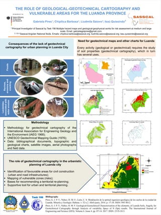
Consequences of the lack of geotechnical
cartography for urban planning in Luanda City
Gabriela Pires1; Chipilica Barbosa2; Liudmila Saiovo3; Isaú Quissindo4
Floods
Ravines,
erosions
and
cracking
Landslides
associated
with
water
erosion
Need for geotechnical maps and other charts for Luanda
Every activity (geological or geotechnical) requires the study
of soil properties (geotechnical cartography), which in turn
has several uses.
Methodology
▪ Methodology for geotechnical cartography of the
International Association for Engineering Geology and
the Environment (IAEG 1968);
▪ UNESCO Geotechnical Mapping Guide (1976);
▪ Data: bibliographical documents, topographic and
geological charts, satellite images, aerial photographs
and field data.
The role of geotechnical cartography in the urbanistic
planning of Luanda city
▪ Identification of favourable areas for civil construction
(urban and road infrastructures);
▪ Mapping of vulnerable zones (risks);
▪ Bases for recommending a territorial re-planning;
▪ Supportive tool for urban and territorial planning.
Bibliography
Pires, G. J. P. T.; Núñez, H. M. F.; León, C. S. Modelación de la aptitud ingeniero-geológica de los suelos de la ciudad de
Luanda. Minería y Geología: Habana. v. 32 n.2. Abril-junio, 2016. p. 17-34. ISSN 1993 8012.
Pires, G. J. P. T.; Núñez, H. M. F. Geological-Geotechnical Characterization of the elements, of Luanda Soils, Angola, for
Geotechinical Cartography through Analysis of variability Space of N (Spt) results. The International Journal of
Engineering and Science (IJES). Volume 6. Issue 4. pp. 07-14. 2017. ISSN: 2319-1813.
Task 196
Administrative
division
Geological-geotechnical survey
Geological survey
Detailed geological survey
Luanda
Legend
Normalized Difference Vegetation Index (NDVI) for Luanda
Legend
Land use map of Luanda
Legend
Road
Water
Agriculture
Use itself (Areas of Old Urban Center)
Residential Areas (New urbanization / condominiums)
Residential Areas (New urbanization / social projects)
Residential Areas (Ordered neighborhoods)
Residential Areas (Peripheral neighborhoods)
Vegetation
Land or land exposed or discovered
Equipments
Fitness
Legend
Communes
Unfavorable
Moderate or intermediate
Favourables