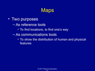
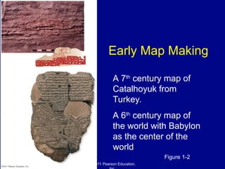
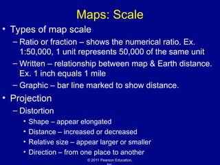
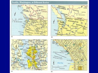
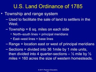
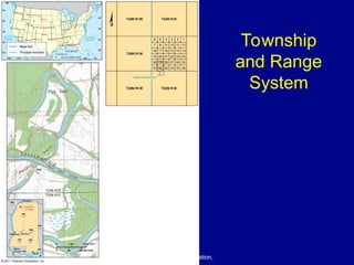
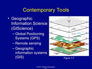
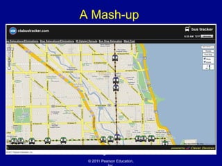
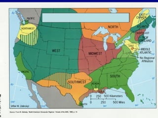
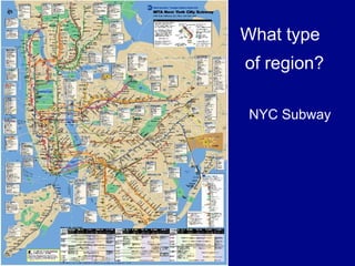
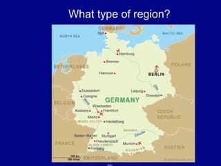
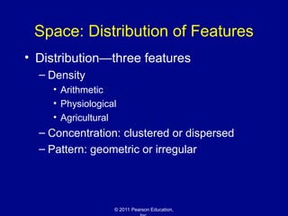
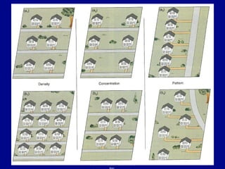
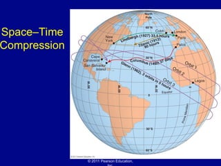
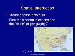
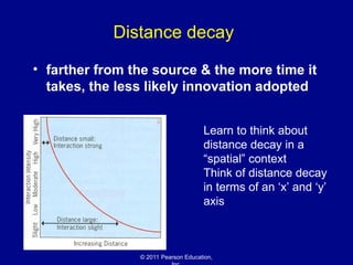
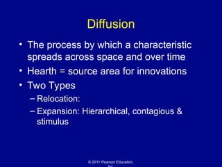
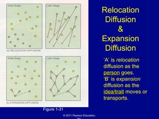
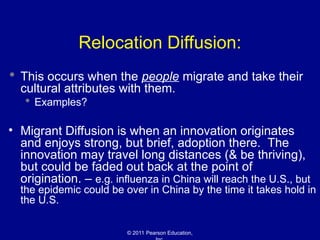
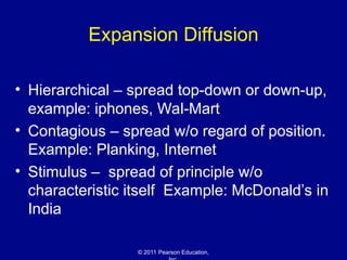
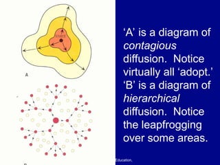
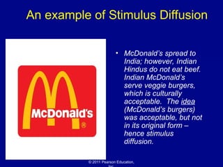
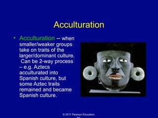
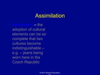
© 2011 Pearson Education,
Chapter 1: Basic Concepts
The Cultural Landscape:
An Introduction to Human Geography
© 2011 Pearson Education,
Defining Geography
• Word coined by Eratosthenes
– Geo = Earth
– Graphia = writing
• Geography thus means “earth writing”
© 2011 Pearson Education,
Contemporary Geography
• Geographers ask where and why
– Location and distribution are important
terms
• Geographers are concerned with the
tension between globalization and local
diversity
• A division: physical geography and
human geography
© 2011 Pearson Education,
Maps
• Two purposes
– As reference tools
• To find locations, to find one’s way
– As communications tools
• To show the distribution of human and physical
features
© 2011 Pearson Education,
Early Map Making
Figure 1-2
A 7th
century map of
Catalhoyuk from
Turkey.
A 6th
century map of
the world with Babylon
as the center of the
world
© 2011 Pearson Education,
Maps: Scale
• Types of map scale
– Ratio or fraction – shows the numerical ratio. Ex.
1:50,000, 1 unit represents 50,000 of the same unit
– Written – relationship between map & Earth distance.
Ex. 1 inch equals 1 mile
– Graphic – bar line marked to show distance.
• Projection
– Distortion
• Shape – appear elongated
• Distance – increased or decreased
• Relative size – appear larger or smaller
• Direction – from one place to another
© 2011 Pearson Education,
U.S. Land Ordinance of 1785
• Township and range system
– Used to facilitate the sale of land to settlers in the
West.
– Township = 6 sq. miles on each side
• North–south lines = principal meridians
• East–west lines = base lines
– Range = location east or west of principal meridians
– Sections = divided into 36 1mile by 1 mile units,
then divided into 4 quarter-sections – ½ mile by ½
miles = 160 acres the size of western homesteads.
© 2011 Pearson Education,
Township
and Range
System
Figure 1-5
© 2011 Pearson Education,
Contemporary Tools
• Geographic
Information Science
(GIScience)
– Global Positioning
Systems (GPS)
– Remote sensing
– Geographic
information systems
(GIS) Figure 1-7
© 2011 Pearson Education,
A Mash-up
Figure 1-8
© 2011 Pearson Education,
Place: Unique Location of a Feature
• Location
– Place names
• Toponym – Texas city names.
– Site – physical features gives distinctive
character
– Situation – relative location of other places
– Mathematical location – Latitude & longitude
© 2011 Pearson Education,
Place: Mathematical Location
• Location of any place can be described
precisely by meridians and parallels
– Meridians (lines of longitude)
• Prime meridian
– Parallels (lines of latitude)
• The equator
© 2011 Pearson Education,
The Cultural Landscape
• A unique combination of social
relationships and physical processes
• Each region = a distinctive landscape
• People = the most important agents of
change to Earth’s surface
© 2011 Pearson Education,
Types of Regions
• Formal (uniform) regions
– Example: Montana
• Functional (nodal) regions
– Example: the circulation area of a
newspaper
• Vernacular (cultural) regions
– Example: the American South
© 2011 Pearson Education,
What type of region?
© 2011 Pearson Education,
What type
of region?
NYC Subway
© 2011 Pearson Education,
What type of region?
© 2011 Pearson Education,
Culture
• Origin from the Latin cultus, meaning “to
care for”
• Two aspects:
– What people care about
• Beliefs, values, and customs
– What people take care of
• Earning a living; obtaining food, clothing, and
shelter
© 2011 Pearson Education,
Cultural Ecology
• The geographic study of human–
environment relationships
• Two perspectives:
– Environmental determinism
– Possibilism
• Modern geographers generally reject environmental
determinism in favor of possibilism
© 2011 Pearson Education,
Physical Processes
• Climate
• Vegetation
• Soil
• Landforms
– These four processes are important for
understanding human activities
© 2011 Pearson Education,
Modifying the Environment
• Examples
– The Netherlands
• Polders
– The Florida Everglades
Figure 1-21
© 2011 Pearson Education,
Scale
• Globalization
– Economic globalization
• Transnational corporations
– Cultural globalization
• Is local culture threatened by globalization?
• What is needed for global culture?
• Opposition to Globalization
© 2011 Pearson Education,
Space: Distribution of Features
• Distribution—three features
– Density
• Arithmetic
• Physiological
• Agricultural
– Concentration: clustered or dispersed
– Pattern: geometric or irregular
© 2011 Pearson Education,
Space–Time
Compression
Figure 1-29
© 2011 Pearson Education,
Spatial Interaction
• Transportation networks
• Electronic communications and
the “death” of geography?
Figure 1-30
© 2011 Pearson Education,
Distance decay
• farther from the source & the more time it
takes, the less likely innovation adopted
Learn to think about
distance decay in a
“spatial” context
Think of distance decay
in terms of an ‘x’ and ‘y’
axis
© 2011 Pearson Education,
Diffusion
• The process by which a characteristic
spreads across space and over time
• Hearth = source area for innovations
• Two Types
– Relocation:
– Expansion: Hierarchical, contagious &
stimulus
© 2011 Pearson Education,
Relocation
Diffusion
&
Expansion
Diffusion
Figure 1-31
‘A’ is relocation
diffusion as the
person
person goes.
‘B’ is expansion
diffusion as the
idea/trait
idea/trait moves or
transports.
© 2011 Pearson Education,
Relocation Diffusion:
 This occurs when the people migrate and take their
cultural attributes with them.
 Examples?
• Migrant Diffusion is when an innovation originates
and enjoys strong, but brief, adoption there. The
innovation may travel long distances (& be thriving),
but could be faded out back at the point of
origination. – e.g. influenza in China will reach the U.S., but
the epidemic could be over in China by the time it takes hold in
the U.S.
© 2011 Pearson Education,
Expansion Diffusion
• Hierarchical – spread top-down or down-up,
example: iphones, Wal-Mart
• Contagious – spread w/o regard of position.
Example: Planking, Internet
• Stimulus – spread of principle w/o
characteristic itself Example: McDonald’s in
India
© 2011 Pearson Education,
‘A’ is a diagram of
contagious
diffusion. Notice
virtually all ‘adopt.’
‘B’ is a diagram of
hierarchical
diffusion. Notice
the leapfrogging
over some areas.
© 2011 Pearson Education,
An example of Stimulus Diffusion
• McDonald’s spread to
India; however, Indian
Hindus do not eat beef.
Indian McDonald’s
serve veggie burgers,
which is culturally
acceptable. The idea
(McDonald’s burgers)
was acceptable, but not
in its original form –
hence stimulus
diffusion.
© 2011 Pearson Education,
Nicholas Christakis: How social
networks predict epidemics
http://www.ted.com/talks/nicholas_christakis_
how_social_networks_predict_epidemics.html
© 2011 Pearson Education,
Acculturation
• Acculturation – when
smaller/weaker groups
take on traits of the
larger/dominant culture.
Can be 2-way process
– e.g. Aztecs
acculturated into
Spanish culture, but
some Aztec traits
remained and became
Spanish culture.
© 2011 Pearson Education,
Assimilation
• Assimilation – the
adoption of cultural
elements can be so
complete that two
cultures become
indistinguishable –
e.g. – jeans being
worn here in the
Czech Republic
© 2011 Pearson Education,
The End.
© 2011 Pearson Education,
Defining Geographic Scales, by
James Rubenstein
• “Geographers think about scale at many
levels, including global, regional, and
local. At the global scale, geographers
recognize that each place on Earth is in
some ways unique. Between the local
and global, geographers construct a
regional scale; a region is an area
characterized by a unique combination
of features.”
© 2011 Pearson Education,

The Cultural Landscape - Chapter 1: Basic Concepts

  • 1.
    © 2011 PearsonEducation, Chapter 1: Basic Concepts The Cultural Landscape: An Introduction to Human Geography
  • 2.
    © 2011 PearsonEducation, Defining Geography • Word coined by Eratosthenes – Geo = Earth – Graphia = writing • Geography thus means “earth writing”
  • 3.
    © 2011 PearsonEducation, Contemporary Geography • Geographers ask where and why – Location and distribution are important terms • Geographers are concerned with the tension between globalization and local diversity • A division: physical geography and human geography
  • 4.
    © 2011 PearsonEducation, Maps • Two purposes – As reference tools • To find locations, to find one’s way – As communications tools • To show the distribution of human and physical features
  • 5.
    © 2011 PearsonEducation, Early Map Making Figure 1-2 A 7th century map of Catalhoyuk from Turkey. A 6th century map of the world with Babylon as the center of the world
  • 6.
    © 2011 PearsonEducation, Maps: Scale • Types of map scale – Ratio or fraction – shows the numerical ratio. Ex. 1:50,000, 1 unit represents 50,000 of the same unit – Written – relationship between map & Earth distance. Ex. 1 inch equals 1 mile – Graphic – bar line marked to show distance. • Projection – Distortion • Shape – appear elongated • Distance – increased or decreased • Relative size – appear larger or smaller • Direction – from one place to another
  • 7.
    © 2011 PearsonEducation,
  • 8.
    © 2011 PearsonEducation, U.S. Land Ordinance of 1785 • Township and range system – Used to facilitate the sale of land to settlers in the West. – Township = 6 sq. miles on each side • North–south lines = principal meridians • East–west lines = base lines – Range = location east or west of principal meridians – Sections = divided into 36 1mile by 1 mile units, then divided into 4 quarter-sections – ½ mile by ½ miles = 160 acres the size of western homesteads.
  • 9.
    © 2011 PearsonEducation, Township and Range System Figure 1-5
  • 10.
    © 2011 PearsonEducation, Contemporary Tools • Geographic Information Science (GIScience) – Global Positioning Systems (GPS) – Remote sensing – Geographic information systems (GIS) Figure 1-7
  • 11.
    © 2011 PearsonEducation, A Mash-up Figure 1-8
  • 12.
    © 2011 PearsonEducation, Place: Unique Location of a Feature • Location – Place names • Toponym – Texas city names. – Site – physical features gives distinctive character – Situation – relative location of other places – Mathematical location – Latitude & longitude
  • 13.
    © 2011 PearsonEducation, Place: Mathematical Location • Location of any place can be described precisely by meridians and parallels – Meridians (lines of longitude) • Prime meridian – Parallels (lines of latitude) • The equator
  • 14.
    © 2011 PearsonEducation, The Cultural Landscape • A unique combination of social relationships and physical processes • Each region = a distinctive landscape • People = the most important agents of change to Earth’s surface
  • 15.
    © 2011 PearsonEducation, Types of Regions • Formal (uniform) regions – Example: Montana • Functional (nodal) regions – Example: the circulation area of a newspaper • Vernacular (cultural) regions – Example: the American South
  • 16.
    © 2011 PearsonEducation, What type of region?
  • 17.
    © 2011 PearsonEducation, What type of region? NYC Subway
  • 18.
    © 2011 PearsonEducation, What type of region?
  • 19.
    © 2011 PearsonEducation, Culture • Origin from the Latin cultus, meaning “to care for” • Two aspects: – What people care about • Beliefs, values, and customs – What people take care of • Earning a living; obtaining food, clothing, and shelter
  • 20.
    © 2011 PearsonEducation, Cultural Ecology • The geographic study of human– environment relationships • Two perspectives: – Environmental determinism – Possibilism • Modern geographers generally reject environmental determinism in favor of possibilism
  • 21.
    © 2011 PearsonEducation, Physical Processes • Climate • Vegetation • Soil • Landforms – These four processes are important for understanding human activities
  • 22.
    © 2011 PearsonEducation, Modifying the Environment • Examples – The Netherlands • Polders – The Florida Everglades Figure 1-21
  • 23.
    © 2011 PearsonEducation, Scale • Globalization – Economic globalization • Transnational corporations – Cultural globalization • Is local culture threatened by globalization? • What is needed for global culture? • Opposition to Globalization
  • 24.
    © 2011 PearsonEducation, Space: Distribution of Features • Distribution—three features – Density • Arithmetic • Physiological • Agricultural – Concentration: clustered or dispersed – Pattern: geometric or irregular
  • 25.
    © 2011 PearsonEducation,
  • 26.
    © 2011 PearsonEducation, Space–Time Compression Figure 1-29
  • 27.
    © 2011 PearsonEducation, Spatial Interaction • Transportation networks • Electronic communications and the “death” of geography? Figure 1-30
  • 28.
    © 2011 PearsonEducation, Distance decay • farther from the source & the more time it takes, the less likely innovation adopted Learn to think about distance decay in a “spatial” context Think of distance decay in terms of an ‘x’ and ‘y’ axis
  • 29.
    © 2011 PearsonEducation, Diffusion • The process by which a characteristic spreads across space and over time • Hearth = source area for innovations • Two Types – Relocation: – Expansion: Hierarchical, contagious & stimulus
  • 30.
    © 2011 PearsonEducation, Relocation Diffusion & Expansion Diffusion Figure 1-31 ‘A’ is relocation diffusion as the person person goes. ‘B’ is expansion diffusion as the idea/trait idea/trait moves or transports.
  • 31.
    © 2011 PearsonEducation, Relocation Diffusion:  This occurs when the people migrate and take their cultural attributes with them.  Examples? • Migrant Diffusion is when an innovation originates and enjoys strong, but brief, adoption there. The innovation may travel long distances (& be thriving), but could be faded out back at the point of origination. – e.g. influenza in China will reach the U.S., but the epidemic could be over in China by the time it takes hold in the U.S.
  • 32.
    © 2011 PearsonEducation, Expansion Diffusion • Hierarchical – spread top-down or down-up, example: iphones, Wal-Mart • Contagious – spread w/o regard of position. Example: Planking, Internet • Stimulus – spread of principle w/o characteristic itself Example: McDonald’s in India
  • 33.
    © 2011 PearsonEducation, ‘A’ is a diagram of contagious diffusion. Notice virtually all ‘adopt.’ ‘B’ is a diagram of hierarchical diffusion. Notice the leapfrogging over some areas.
  • 34.
    © 2011 PearsonEducation, An example of Stimulus Diffusion • McDonald’s spread to India; however, Indian Hindus do not eat beef. Indian McDonald’s serve veggie burgers, which is culturally acceptable. The idea (McDonald’s burgers) was acceptable, but not in its original form – hence stimulus diffusion.
  • 35.
    © 2011 PearsonEducation, Nicholas Christakis: How social networks predict epidemics http://www.ted.com/talks/nicholas_christakis_ how_social_networks_predict_epidemics.html
  • 36.
    © 2011 PearsonEducation, Acculturation • Acculturation – when smaller/weaker groups take on traits of the larger/dominant culture. Can be 2-way process – e.g. Aztecs acculturated into Spanish culture, but some Aztec traits remained and became Spanish culture.
  • 37.
    © 2011 PearsonEducation, Assimilation • Assimilation – the adoption of cultural elements can be so complete that two cultures become indistinguishable – e.g. – jeans being worn here in the Czech Republic
  • 38.
    © 2011 PearsonEducation, The End.
  • 39.
    © 2011 PearsonEducation, Defining Geographic Scales, by James Rubenstein • “Geographers think about scale at many levels, including global, regional, and local. At the global scale, geographers recognize that each place on Earth is in some ways unique. Between the local and global, geographers construct a regional scale; a region is an area characterized by a unique combination of features.”
  • 40.
    © 2011 PearsonEducation,

Editor's Notes

  • #9 Note the symbols used on the map-dots for cities-size of dot indicates the size of the city. A star or dot with a circle=capital city Red lines=roads Double red line=4-lane highway Black line=railroad Patterns and appropriate color indicate water, forests, farmland, etc. Lines used to represent political and administrative boundaries.
  • #16 Example: don’t put a textile mill were cotton grows, locate where low cost labor. Geog. Job to sort out the associations among various social characteristics, each of which is uniquely distributed across Earth’s surface.
  • #22 Environmental determinism – a 19th century and early 20th approach to the study of geography which argued that the general laws sought by human geographers could be found in the physical sciences. G study of physical environment caused human activities. In his book Principles of Human Geography (1940) Ellsworth Huntington stated that climate was the determining factor in progress, energy and the culture of people. Environmental Determinists hold that human behavior individually and collectively is strongly affected by and controlled or determined by the physical environment. Possibilism – physical environment may limit some human action, but people have the ability to adjust to their environment. Choose a course of action from many alternatives. Population could be a problem, people adjust, new technology, controlling population growth, eating different foods migrating, ets.
  • #25 Producing a world that is more uniform, integrated, & interdependent. Once difficult to move large sums of $$$, technology makes moving $ easier. Same things in culture. Needed: Common language. Opposition: lead to intolerance of people w/ different beliefs. 9/11
  • #27 Density-In A we see 6 houses on 1 acre of land. And in B we see 12 houses per acre Concentration-in A we see the houses dispersed and in B we see them clustered. Pattern-in A the houses are in a single linear arrangement, in B the arrangement is irregular.
  • #28 Reduction of the time it takes for something to reach another place.
  • #29 When places are connected to each other through a network, geographers say there is spatial interaction between them. No geography even more important than before, being on the internet is valuable info for businesses that target advertisement and products to specific tastes & preferences of a particular place.
  • #31 Single set of paper money was issued, each country minted coins that could be used in all countries. Scientist took month to month sample to in France to monitor the proportion of coin from each of the other 11 countries. The % of coins from a particular country is a measure of the level of relocation diffusion to and from France.
  • #32 Sequential diffusion process in which the items being diffused are transmitted by their carrier agents as they evacuate the old areas and relocate to new ones. The most common form of relocation diffusion involves the spreading of innovations by a migrating population.
  • #34 Hierarchical Diffusion – spread of an idea through an established structure usually from people or areas of power down to other people or areas Contagious Diffusion – spread of an idea/trait/concept through a group of people or an area equally without regard to social class, economic position or position of power. Stimulus Diffusion – the spread of an underlying principle even though the characteristic itself does not spread.
  • #36 Stimulus Diffusion – the spread of an underlying principle even though the characteristic itself does not spread. OR Stimulus Diffusion - involves the transfer of an underlying concept or idea, without the specific accompanying traits due to some cultural or other barrier to the movement of the idea