2
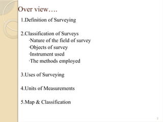
Over view….
1.Definition ofSurveying
2.Classification of Surveys
·Nature of the field of survey
·Objects of survey
·Instrument used
·The methods employed
3.Uses of Surveying
4.Units of Measurements
5.Map & Classification
3.
3
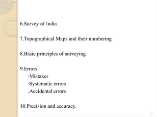
6.Survey of India
7.TopographicalMaps and their numbering
8.Basic principles of surveying
9.Errors
·Mistakes
·Systematic errors
.Accidental errors
10.Precision and accuracy.
4.
4
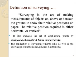
Definition of surveying…..
“Surveyingis the art of making
measurements of objects on, above or beneath
the ground to show their relative positions on
paper. The relative position required is either
horizontal or vertical”.
It also includes the art of establishing points by
predetermined angular & linear measurements.
The application of surveying requires skills as well as the
knowledge of mathematics, physics & astronomy
5.
5
APPLICATIONS OF SURVEYING:
1.Astronomical survey helps in the study of astronomical movements of
planets and for calculating local standard times.
2.Maps prepared for countries, states and districts, etc. avoid disputes.
3.Plans prepared record the property boundaries of private, public and
government which help in avoiding unnecessary controversies.
4.Topographical maps showing natural features like rivers, streams, hills,
forests help in planning irrigation projects and flood control measures.
5.Road maps help travelers and tourists to plan their programmers.
6.Locality plan help in identifying location of houses and offices in the area
7.Maps and plans help in planning and estimating various transportation
projects like roads, bridges, railways and airports.
6.
6
Contd..
8.For planning andexecuting water supply and sanitary projects one has to
go for surveying first.
9.Marine and hydrographic surveys help in planning navigation routes and
harbors.
10.For making final payments in large projects surveying is to be carried out
11.Military surveys help in strategic planning
12.For exploring mineral wealth mine surveys are required.
13.Geological surveys are necessary for determining different strata in the
earth’s crust so that proper location is found for reservoirs.
14.Archaeological surveys are required for unearthing relics of antiquity.
7.
7
CLASSIFICATION OF SURVEYING:
Surveyingmay be classified based on the following three points:
1.Natural of the field of survey
2.Objects of survey
3.Instrument used
4.The methods employed
8.
8
I. Classification Basedon Nature of the Field of Survey :
On this basis field of survey may be classified as land survey. Marine or
hydraulic survey and astronomical survey.
1.Land survey: It involves measurement of various objects on land.
i. Topographic surveys: They consist of measurement of various points
to plot natural features such as rivers, streams, lakes, hill and forests as
well as man – made features like roads, railways, towns, villages and
canals.
ii. Cadastral survey: These surveys are for marking boundaries of
municipalities, states, etc. the surveys made to mark properties of
individual also come under this category.
iii. City survey: The surveys made in connection with the construction of
streets, water supply and sewage lines fall under this category
9.
9
Contd…
2.Marine or HydrographicSurveys: The survey conducted
to find depth of water at various points in bodies of water
like sea, river and lakes fall under this category of surveying.
Finding depth of water at specified points is known as
soundings.
3.Astronomical Surveys: Observations made to heavenly
bodies like sun and stars to locate absolute position of points
on the earth and for the purpose of calculating local times is
known as astronomical survey.
10.
10
II. Classification Basedon Object of Surveying
On the basis of objective of surveying, the classification can
be as engineering survey. Military survey, mines survey,
geological survey and archaeological survey.
1.Engineering survey: The objective of this type of surveying
is to collect data for designing roads, railways, irrigation,
water supply and sewage disposal projects. These surveys
may be further subdivided into:
a. Reconnaissance survey: for determining feasibility ad
estimation of the scheme.
b. Preliminary survey :for collecting more information to
estimate the cost of the project selected, and
c. Location survey: to set the work on the ground.
11.
11
2.Military Survey: Thissurvey is meant for working out
points of strategic importance.
3.Mine survey: This is used for exploring mineral wealth.
4.Geological survey: this survey is for finding different
strata in the earth’s crust.
5.Archaeological survey: this survey is for unearthing
relics of antiquity.
12.
12
III. Based onthe instruments used, surveying
may be classified into the following:
1. Chain Survey
2.Compass Survey
3.Plane Table Survey
4.Theodolite Survey
5.Tacheometric Survey
6.Modern Survey using electronic equipment like distance metres and
total stations.
7.Photographic and Aerial Survey.
13.
13
IV. Classification Basedon the Methods
Employed :
Based on the methods employed, surveying may be classified as
triangulation and traversing.
1.Triangulation: In this method control points are established
through a network of triangles
2.Traversing: In this scheme of control points consist of a series
of connected points established through linear and angular
measurements. If last line meets the starting point it is called as
closed traverse. If it does not meet, it is known as open
traverse.
14.
14
UNITS OF MEASUREMENTS
Thereare four types of measurements used in Plane
surveying :
Horizontal distance
Vertical distance
Horizontal angle
Vertical angle
Commonly used linear units in surveying are
Inches,Feet,Yards,poles,chains,furlong,millimeter,cent
imetrs,meters.kilometers and so on….
15.
15
Commonly used Angularmeasures are in surveying
are
Sexagesimal system
Centesimal system
Hours system
16.
16
PRINCIPLES OF SURVEYING
There are two fundamental principles upon
which various methods of surveyeying are
based.
1. Location of point by measurement from two
points of reference
2. Working from whole to part
17.
17
SURVEY OF INDIA
The survey of India is the oldest scientific department
of Government of India. It was established in 1767 by
the East India Company
The maps prepared meet the needs of defense forces,
planners and the scientists in the field of
geosciences, land and resource management.
The topographical maps show details of natural
features like roads, railways, towns villages and
canals. They also show contour lines
18.
18
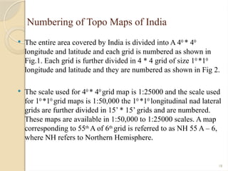
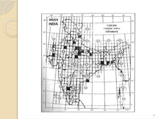
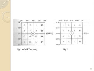
Numbering of TopoMaps of India
The entire area covered by India is divided into A 40
* 40
longitude and latitude and each grid is numbered as shown in
Fig.1. Each grid is further divided in 4 * 4 grid of size 10
*10
longitude and latitude and they are numbered as shown in Fig 2.
The scale used for 40
* 40
grid map is 1:25000 and the scale used
for 10
*10
grid maps is 1:50,000 the 10
*10
longitudinal nad lateral
grids are further divided in 15’ * 15’ grids and are numbered.
These maps are available in 1:50,000 to 1:25000 scales. A map
corresponding to 55th
A of 6th
grid is referred to as NH 55 A – 6,
where NH refers to Northern Hemisphere.
21
ERRORS IN SURVEYING
TYPESOF ERRORS:
The errors which creep in surveying may be classified into
the following three:
1.Mistakes
2.Systematic errors
3.Accidental errors
22.
22
1. Mistakes:
Mistakes arethe errors due to carelessness of the observer.
They may be due to wrong reading or recording of the
observations. These errors are very large and can be easily
detected by the following field procedures:
a)Carefully targeting objects before taking reading
b)Taking multiple scale readings
c)Recorded loudly announcing the readings so that
reader hears what he records.
d)Taking additional readings for checking.
23.
23
2. Systematic errors:
The errors which follow a well – defined pattern are
classified as systematic errors. They can be determined by
mathematical expressions.
They are regarded as positive, if they make result too great
and as negative if they make result too small.
Examples of such errors are:
Use of a tape which is shorter than the actual as per
marking or using a steel tape at a temperature different
from calibrated temperature. If tape is short, makes each
measured length longer, hence contributes positive error.
This type of errors is called cumulative errors, since each
measurement adds to the error in the same sense
24.
24
3. Accidental errors:
There are errors in measurements which cannot be
prevented, even with sufficient care.
These errors may be positive or negative their
magnitude may vary from reading to reading for
example taking a reading with a survey instrument
Human eye has a limitation of distinguishing
between two close readings.
Marking the end of a chain length is another
common example of accidental error.
25.
25
SOURCES OF ERRORS
Errorsmay arise from the following sources:
1.Instrumental errors
2.Natural errors
3.Human limitations
4.Carelessness