Stream Team Investigators
•Download as PPT, PDF•
0 likes•194 views
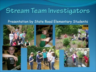
Students at State Road Elementary School are presenting their Stream Team data to the Monroe County Water Coalition at their meeting in June 2010.
Report
Share
Report
Share

Recommended
AggregateBostonAGS2016
This document provides an overview of the evolution of aggregate supply to Boston, Massachusetts. It discusses how Boston was originally developed on glacial sand and gravel deposits starting in the 1860s. Aggregate sources then expanded through the development of vertically integrated quarries and the excavation of pits into ledge rock. Transportation infrastructure like railroads, trucks, barges, and the interstate system helped aggregate be transported into Boston from farther locations. The document gives details on the geology and specific rock types supplying quarries around Boston, and provides a counter-clockwise tour of various quarry locations, rock types, and years of operation. It concludes with contact information for the presentation author.
PrideCampSchedule--FINAL (3)
The inaugural Pride Camp at the University of Mississippi was scheduled to take place on Saturday, August 29, 2015 from 8:30 am to 1:30 pm in the Union Ballroom. The day included a continental breakfast, introductions by directors, icebreakers, panels on resources for LGBTQ students and managing microaggressions and implicit bias, a student panel, networking luncheon, and closing remarks. Upcoming LGBTQ events were also listed.
Brians annual meeting2011 presentation
The document summarizes the annual meeting of a community organization whose mission is to protect and restore salmon populations through habitat restoration projects. It outlines several habitat restoration projects completed in 2010 and planned for 2011-2012, including estuary, floodplain, and fish passage projects. It also thanks partner organizations for their support of salmon recovery efforts in the region.
2011 annual meeting presentation part 1
The annual meeting summary covered several habitat restoration projects completed in 2010 and projects under development. Projects in 2010 included restoring estuaries at Beachcrest and Big Cove, Phase I of floodplain restoration on the Greenwater River, instream habitat restoration in the Ohop Valley and on Elbow Lake Creek, and riparian planting. Projects under development included further work on Goldsborough Creek and nearshore habitat projects in WRIA 15. Partnerships with local tribes, counties, and organizations helped fund and implement these salmon habitat restoration efforts.
Geog5 field trip journal & Field Questions
The document summarizes Adela Lopez's field trip journal from a geography class trip. The trip included visits to Mormon Rocks Formation near the San Andreas Fault, Fossil Falls which shows evidence of ancient lake flows, cinder hill from volcanic activity, and Convict Lake. Sites provided evidence of Native American habitation and included house rings, petroglyphs, and obsidian flakes. Stops also included Mono Lake to see tufa formations and former shorelines, and Owens River valley. The trip gave insights into geology, ecology and helped the student appreciate their environment.
Nyscate Presentation
This document outlines an activity where students explore macros and collect data as scientists, sharing what they learn about purifying water and examining their scientific work. The activity encourages students to design solutions for providing potable water worldwide by removing salt and bacteria using a process that purifies water.
Macroinvertebrate Samples
This document discusses various macroinvertebrates found in a creek during a sampling in March 2009, including a caddisfly, mayfly nymph, stonefly nymphs that were developing wings, riffle beetle, crayfish, amphipods, aquatic worm, and unknown invertebrates in need of identification. Photos were also taken of macroinvertebrates like an isopod and stonefly nymph under magnification.
Exploring PBL
The document discusses using project-based learning (PBL) to promote self-directed learning. It defines inquiry as imagination and explores using PBL to connect topic-based and concept-based inquiry. Examples of PBL are provided, and the roles of teachers and students are discussed as shifting from teacher-led to more student-initiated. Technology tools to support student learning are listed, and ways to facilitate student metacognition through journals and discussions are provided.
2014-IrishtownGreenway-Final-WEB-LOWRES
This document provides a strategic plan for the Flats West Bank area of Cleveland, Ohio, focusing on connecting the region to Lake Erie through the proposed Lake Link Trail. It includes background research and analysis of the physical, regulatory, and socioeconomic conditions of the area. Community outreach was also conducted. The plan establishes a vision and goals, and provides initiatives and recommendations related to greenway and open space design, development opportunities, and marketing strategies. The goal is to revitalize the 86-acre Flats West Bank neighborhood through the Lake Link Trail by capitalizing on trends of downtown living and enhancing access to Lake Erie.
Poster watershed FINAL
Water quality monitoring of tributaries flowing into Otsego Lake continued in 2015. Nutrient concentrations and physiochemical data were collected from five tributaries providing 70% of inflow. Past studies attributed increasing eutrophication in the lake to nutrient loading from human sources like wastewater and agriculture. Best Management Practices had been implemented near tributaries to improve water quality. High precipitation in 2015 caused nutrient influxes into tributaries. Phosphorus levels decreased while nitrogen fluctuated annually. Sites also had cooler temperatures and more dissolved oxygen compared to previous years.
SDS Whitepaper
Colorado Springs has a long history of planning for its water needs dating back to the 1870s. As the city grew further from water sources like Fountain Creek, it developed an extensive water collection and delivery system involving numerous reservoirs, pipelines, and transmountain diversion projects. The Southern Delivery System (SDS) was identified in Colorado Springs' 1996 Water Resource Plan as the major new delivery system needed to meet 55% of the city's future water demands, as existing systems were nearing capacity. SDS will be a regional project to transport water from Pueblo Reservoir through 62 miles of pipeline to Colorado Springs and partner communities. Phase I is currently under construction at an estimated cost of $880 million to be completed by 2016.
KYTC Freight
The document discusses Kentucky's funding of shortline railroad grants and riverport improvement grants between 2010-2016. For shortline railroad grants, funding amounts ranged from $4 million to $3.2 million with matching requirements of 50/50 or 80/20 depending on the fiscal years. The grants were used for projects like reconstruction, safety improvements, and signaling upgrades. For riverport improvement grants, $500,000 was provided each year between 2013-2016 to fund projects like dredging and dock maintenance. In total, the grants funded over 200 shortline railroad crossing projects and 27 riverport projects across Kentucky.
Pierce County Watershed Health Trends 2012
This document provides an overview of Pierce County's watershed health monitoring programs and activities in Water Year 2013. It discusses two main programs - the Watershed Health Status and Trends program and the NPDES Municipal Stormwater Permit program. In WY2013, the county conducted various monitoring activities including water quality sampling at 53 streams, biological sampling of aquatic insects at 32 streams, monitoring of 11 weather stations, 15 water level loggers, and 11 groundwater wells. It also discusses the county's freshwater streams monitoring, biological monitoring, lakes monitoring, shellfish bacteria monitoring, and methods for accessing the monitoring data online.
Reducing sediment and nutrient loadings through river and streambank restoration
Reducing sediment and nutrient loadings through river and streambank restorationSoil and Water Conservation Society
This document summarizes stream restoration projects in the Beaver Lake watershed in Northwest Arkansas. It discusses how streambank erosion contributes significant amounts of sediment and nutrients to tributaries of Beaver Lake, which is the drinking water source for over 420,000 people. The document outlines several completed restoration projects, measuring their success in reducing sediment and nutrient loads through monitoring streambank erosion rates and water quality parameters. It concludes with recommendations for a new large-scale initiative to restore multiple miles of the West Fork White River through a combination of stream restoration and agricultural conservation practices.Strengthening the White River Watershed: CRO Retreat Pecha Kucha
Examples of innovative watershed restoration and resilience projects in Vermont's White River Watershed. Pecha Kucha presented by Mary Russ of the White River Partnership at the first Community Resilience Organizations (CROs) retreat. May 17, 2105.
Grandforks, USA, Regarding Flooding Issues
The document discusses a proposal for flood control in the Red River Basin area of Grand Forks, North Dakota. It proposes building a floodway and dam to divert water from the Red Lake River around Grand Forks during flood risks. The dam area would include public spaces like an interpretive center, cafe, and fishing areas. It would be crossed by both vehicle and pedestrian bridges connected to trails. Drawings and diagrams show the site plan, building designs, and technical details of how the dam and floodway would operate during times of flooding.
StreamSweepers 2014 Short Visual Presentation
The document outlines the 2014 StreamSweepers program which trained and deployed crews to assess and clean up the Rapidan and Robinson Rivers. It discusses the classroom and hands-on training the crews received in environmental science and river safety. The crews then conducted water quality testing, macroinvertebrate counts, and ecological assessments along the rivers. They marked and removed large amounts of trash from the rivers over many exhausting days, making a big impact but still leaving some trash behind. The document proposes future public access points along the rivers to encourage stewardship.
2014 Watershed Health Report Card
The document provides an overview and results from the 2014 Watershed Health Report Card for Pierce County. It discusses two key metrics used to evaluate watershed health: 1) the rate of compliance with stormwater requirements, and 2) trends in watershed health as measured by water quality and benthic indices. Overall compliance rates have increased countywide since 2009. Some watersheds showed improvements in both indices while others showed declines or mixed results. Specific results are presented for several watersheds, including the Key Peninsula/Islands, Nisqually, and Chambers-Clover watersheds.
Genesee Valley Greenway State Park - History
This show covers canal and railroad history of the historic transportation corridor that transitioned to the Genesee Valley Greenway and now the GVGSP, New York State's newest linear park.
Fogvg program april 2014
History and development of the Genesee Valley Greenway and transition to a New York State Linear Park.
WaterintheEnvfinalpaper
The document provides a history and analysis of water quality in the Columbia Slough in Portland, Oregon. It describes how Native Americans, pioneers, and industries utilized and polluted the slough over time. Untreated sewage and industrial waste were dumped into the slough for decades, degrading water quality. Restoration efforts since the 1990s have improved habitat for wildlife and opened the slough for recreation. Water samples from upstream and downstream sites showed no significant differences in parameters like temperature, nitrates, and phosphates, but dissolved oxygen was significantly lower upstream, indicating pollution affects water quality.
Bear River Development Project
The Bear River Development Project is the result of the Utah State Legislature’s 1991 Bear River Development Act. The Act allocates water to four entities: Bear River Water Conservancy District, Cache County, Jordan Valley Water Conservancy District and Weber Basin Water Conservancy District.
North Valleys Transportation Study January 25, 2017
The Washoe Regional Transportation Commission released a draft traffic study that shows growth in the North Valleys will lead to further congestion if measures aren’t taken to address traffic problems.
“Some of the arterials and collectors connecting U.S. 395 and the North Valleys neighborhoods are anticipated experience close to or more than a 200-percent increase,” the report indicated.
RPC_FAIRLAWN CG 2014
The document provides information about three local communities - the City of Fairlawn, Bath Township, and Copley Township. It includes highlights about each community's government, history, safety services, parks, libraries, schools, and local businesses. Events like Fairlawn's Independence Day parade, Bath Township's annual Community Days, and the Copley Creekside Farmers Market are mentioned. The document serves as a guide for residents and visitors to learn more about the area.
Canals presentation
Lesson plan created by Christine Donoghue, July-August, 2013, as part of the NEH “Inventing America” seminar, Lowell, Massachusetts
Natrona County Conservation District - Pathways to Water Quality
Natrona County Conservation District - Pathways to Water QualityNational Association of Conservation Districts
The North Platte River in Wyoming has been removed from the state's impaired waters list due to successful efforts to reduce selenium levels. Non-point source pollution from irrigated agriculture was causing elevated selenium. Through funding from EPA grants and local partners, over 1,600 acres of flood irrigation have been converted to sprinklers, reducing contact time between water and selenium-rich soils. Piping earthen ditches has also helped to minimize the transport of selenium in the watershed. Through these projects, selenium levels have declined sufficiently for the North Platte River to be delisted.Minutes150115
The Mohawk Towpath Scenic Byway Coalition held its quarterly meeting on January 15, 2015. In attendance were representatives from various municipalities along the Byway. The Treasurer's report showed $38,301.67 total funds. A conflict of interest policy was adopted. Plans were discussed for interpreting historic sites along the Byway and celebrating the centennial of the Flight of Locks in May 2015. Officers were nominated for the coming year. Future meetings were scheduled in April, July and October 2015 to continue the Coalition's work promoting the Byway.
Beyond Degrees - Empowering the Workforce in the Context of Skills-First.pptx
Iván Bornacelly, Policy Analyst at the OECD Centre for Skills, OECD, presents at the webinar 'Tackling job market gaps with a skills-first approach' on 12 June 2024
ANATOMY AND BIOMECHANICS OF HIP JOINT.pdf
it describes the bony anatomy including the femoral head , acetabulum, labrum . also discusses the capsule , ligaments . muscle that act on the hip joint and the range of motion are outlined. factors affecting hip joint stability and weight transmission through the joint are summarized.
More Related Content
Similar to Stream Team Investigators
2014-IrishtownGreenway-Final-WEB-LOWRES
This document provides a strategic plan for the Flats West Bank area of Cleveland, Ohio, focusing on connecting the region to Lake Erie through the proposed Lake Link Trail. It includes background research and analysis of the physical, regulatory, and socioeconomic conditions of the area. Community outreach was also conducted. The plan establishes a vision and goals, and provides initiatives and recommendations related to greenway and open space design, development opportunities, and marketing strategies. The goal is to revitalize the 86-acre Flats West Bank neighborhood through the Lake Link Trail by capitalizing on trends of downtown living and enhancing access to Lake Erie.
Poster watershed FINAL
Water quality monitoring of tributaries flowing into Otsego Lake continued in 2015. Nutrient concentrations and physiochemical data were collected from five tributaries providing 70% of inflow. Past studies attributed increasing eutrophication in the lake to nutrient loading from human sources like wastewater and agriculture. Best Management Practices had been implemented near tributaries to improve water quality. High precipitation in 2015 caused nutrient influxes into tributaries. Phosphorus levels decreased while nitrogen fluctuated annually. Sites also had cooler temperatures and more dissolved oxygen compared to previous years.
SDS Whitepaper
Colorado Springs has a long history of planning for its water needs dating back to the 1870s. As the city grew further from water sources like Fountain Creek, it developed an extensive water collection and delivery system involving numerous reservoirs, pipelines, and transmountain diversion projects. The Southern Delivery System (SDS) was identified in Colorado Springs' 1996 Water Resource Plan as the major new delivery system needed to meet 55% of the city's future water demands, as existing systems were nearing capacity. SDS will be a regional project to transport water from Pueblo Reservoir through 62 miles of pipeline to Colorado Springs and partner communities. Phase I is currently under construction at an estimated cost of $880 million to be completed by 2016.
KYTC Freight
The document discusses Kentucky's funding of shortline railroad grants and riverport improvement grants between 2010-2016. For shortline railroad grants, funding amounts ranged from $4 million to $3.2 million with matching requirements of 50/50 or 80/20 depending on the fiscal years. The grants were used for projects like reconstruction, safety improvements, and signaling upgrades. For riverport improvement grants, $500,000 was provided each year between 2013-2016 to fund projects like dredging and dock maintenance. In total, the grants funded over 200 shortline railroad crossing projects and 27 riverport projects across Kentucky.
Pierce County Watershed Health Trends 2012
This document provides an overview of Pierce County's watershed health monitoring programs and activities in Water Year 2013. It discusses two main programs - the Watershed Health Status and Trends program and the NPDES Municipal Stormwater Permit program. In WY2013, the county conducted various monitoring activities including water quality sampling at 53 streams, biological sampling of aquatic insects at 32 streams, monitoring of 11 weather stations, 15 water level loggers, and 11 groundwater wells. It also discusses the county's freshwater streams monitoring, biological monitoring, lakes monitoring, shellfish bacteria monitoring, and methods for accessing the monitoring data online.
Reducing sediment and nutrient loadings through river and streambank restoration
Reducing sediment and nutrient loadings through river and streambank restorationSoil and Water Conservation Society
This document summarizes stream restoration projects in the Beaver Lake watershed in Northwest Arkansas. It discusses how streambank erosion contributes significant amounts of sediment and nutrients to tributaries of Beaver Lake, which is the drinking water source for over 420,000 people. The document outlines several completed restoration projects, measuring their success in reducing sediment and nutrient loads through monitoring streambank erosion rates and water quality parameters. It concludes with recommendations for a new large-scale initiative to restore multiple miles of the West Fork White River through a combination of stream restoration and agricultural conservation practices.Strengthening the White River Watershed: CRO Retreat Pecha Kucha
Examples of innovative watershed restoration and resilience projects in Vermont's White River Watershed. Pecha Kucha presented by Mary Russ of the White River Partnership at the first Community Resilience Organizations (CROs) retreat. May 17, 2105.
Grandforks, USA, Regarding Flooding Issues
The document discusses a proposal for flood control in the Red River Basin area of Grand Forks, North Dakota. It proposes building a floodway and dam to divert water from the Red Lake River around Grand Forks during flood risks. The dam area would include public spaces like an interpretive center, cafe, and fishing areas. It would be crossed by both vehicle and pedestrian bridges connected to trails. Drawings and diagrams show the site plan, building designs, and technical details of how the dam and floodway would operate during times of flooding.
StreamSweepers 2014 Short Visual Presentation
The document outlines the 2014 StreamSweepers program which trained and deployed crews to assess and clean up the Rapidan and Robinson Rivers. It discusses the classroom and hands-on training the crews received in environmental science and river safety. The crews then conducted water quality testing, macroinvertebrate counts, and ecological assessments along the rivers. They marked and removed large amounts of trash from the rivers over many exhausting days, making a big impact but still leaving some trash behind. The document proposes future public access points along the rivers to encourage stewardship.
2014 Watershed Health Report Card
The document provides an overview and results from the 2014 Watershed Health Report Card for Pierce County. It discusses two key metrics used to evaluate watershed health: 1) the rate of compliance with stormwater requirements, and 2) trends in watershed health as measured by water quality and benthic indices. Overall compliance rates have increased countywide since 2009. Some watersheds showed improvements in both indices while others showed declines or mixed results. Specific results are presented for several watersheds, including the Key Peninsula/Islands, Nisqually, and Chambers-Clover watersheds.
Genesee Valley Greenway State Park - History
This show covers canal and railroad history of the historic transportation corridor that transitioned to the Genesee Valley Greenway and now the GVGSP, New York State's newest linear park.
Fogvg program april 2014
History and development of the Genesee Valley Greenway and transition to a New York State Linear Park.
WaterintheEnvfinalpaper
The document provides a history and analysis of water quality in the Columbia Slough in Portland, Oregon. It describes how Native Americans, pioneers, and industries utilized and polluted the slough over time. Untreated sewage and industrial waste were dumped into the slough for decades, degrading water quality. Restoration efforts since the 1990s have improved habitat for wildlife and opened the slough for recreation. Water samples from upstream and downstream sites showed no significant differences in parameters like temperature, nitrates, and phosphates, but dissolved oxygen was significantly lower upstream, indicating pollution affects water quality.
Bear River Development Project
The Bear River Development Project is the result of the Utah State Legislature’s 1991 Bear River Development Act. The Act allocates water to four entities: Bear River Water Conservancy District, Cache County, Jordan Valley Water Conservancy District and Weber Basin Water Conservancy District.
North Valleys Transportation Study January 25, 2017
The Washoe Regional Transportation Commission released a draft traffic study that shows growth in the North Valleys will lead to further congestion if measures aren’t taken to address traffic problems.
“Some of the arterials and collectors connecting U.S. 395 and the North Valleys neighborhoods are anticipated experience close to or more than a 200-percent increase,” the report indicated.
RPC_FAIRLAWN CG 2014
The document provides information about three local communities - the City of Fairlawn, Bath Township, and Copley Township. It includes highlights about each community's government, history, safety services, parks, libraries, schools, and local businesses. Events like Fairlawn's Independence Day parade, Bath Township's annual Community Days, and the Copley Creekside Farmers Market are mentioned. The document serves as a guide for residents and visitors to learn more about the area.
Canals presentation
Lesson plan created by Christine Donoghue, July-August, 2013, as part of the NEH “Inventing America” seminar, Lowell, Massachusetts
Natrona County Conservation District - Pathways to Water Quality
Natrona County Conservation District - Pathways to Water QualityNational Association of Conservation Districts
The North Platte River in Wyoming has been removed from the state's impaired waters list due to successful efforts to reduce selenium levels. Non-point source pollution from irrigated agriculture was causing elevated selenium. Through funding from EPA grants and local partners, over 1,600 acres of flood irrigation have been converted to sprinklers, reducing contact time between water and selenium-rich soils. Piping earthen ditches has also helped to minimize the transport of selenium in the watershed. Through these projects, selenium levels have declined sufficiently for the North Platte River to be delisted.Minutes150115
The Mohawk Towpath Scenic Byway Coalition held its quarterly meeting on January 15, 2015. In attendance were representatives from various municipalities along the Byway. The Treasurer's report showed $38,301.67 total funds. A conflict of interest policy was adopted. Plans were discussed for interpreting historic sites along the Byway and celebrating the centennial of the Flight of Locks in May 2015. Officers were nominated for the coming year. Future meetings were scheduled in April, July and October 2015 to continue the Coalition's work promoting the Byway.
Similar to Stream Team Investigators (19)
Reducing sediment and nutrient loadings through river and streambank restoration
Reducing sediment and nutrient loadings through river and streambank restoration
Strengthening the White River Watershed: CRO Retreat Pecha Kucha
Strengthening the White River Watershed: CRO Retreat Pecha Kucha
North Valleys Transportation Study January 25, 2017
North Valleys Transportation Study January 25, 2017
Natrona County Conservation District - Pathways to Water Quality
Natrona County Conservation District - Pathways to Water Quality
Recently uploaded
Beyond Degrees - Empowering the Workforce in the Context of Skills-First.pptx
Iván Bornacelly, Policy Analyst at the OECD Centre for Skills, OECD, presents at the webinar 'Tackling job market gaps with a skills-first approach' on 12 June 2024
ANATOMY AND BIOMECHANICS OF HIP JOINT.pdf
it describes the bony anatomy including the femoral head , acetabulum, labrum . also discusses the capsule , ligaments . muscle that act on the hip joint and the range of motion are outlined. factors affecting hip joint stability and weight transmission through the joint are summarized.
বাংলাদেশ অর্থনৈতিক সমীক্ষা (Economic Review) ২০২৪ UJS App.pdf
বাংলাদেশের অর্থনৈতিক সমীক্ষা ২০২৪ [Bangladesh Economic Review 2024 Bangla.pdf] কম্পিউটার , ট্যাব ও স্মার্ট ফোন ভার্সন সহ সম্পূর্ণ বাংলা ই-বুক বা pdf বই " সুচিপত্র ...বুকমার্ক মেনু 🔖 ও হাইপার লিংক মেনু 📝👆 যুক্ত ..
আমাদের সবার জন্য খুব খুব গুরুত্বপূর্ণ একটি বই ..বিসিএস, ব্যাংক, ইউনিভার্সিটি ভর্তি ও যে কোন প্রতিযোগিতা মূলক পরীক্ষার জন্য এর খুব ইম্পরট্যান্ট একটি বিষয় ...তাছাড়া বাংলাদেশের সাম্প্রতিক যে কোন ডাটা বা তথ্য এই বইতে পাবেন ...
তাই একজন নাগরিক হিসাবে এই তথ্য গুলো আপনার জানা প্রয়োজন ...।
বিসিএস ও ব্যাংক এর লিখিত পরীক্ষা ...+এছাড়া মাধ্যমিক ও উচ্চমাধ্যমিকের স্টুডেন্টদের জন্য অনেক কাজে আসবে ...
Pollock and Snow "DEIA in the Scholarly Landscape, Session One: Setting Expec...
Pollock and Snow "DEIA in the Scholarly Landscape, Session One: Setting Expec...National Information Standards Organization (NISO)
This presentation was provided by Steph Pollock of The American Psychological Association’s Journals Program, and Damita Snow, of The American Society of Civil Engineers (ASCE), for the initial session of NISO's 2024 Training Series "DEIA in the Scholarly Landscape." Session One: 'Setting Expectations: a DEIA Primer,' was held June 6, 2024.BBR 2024 Summer Sessions Interview Training
Qualitative research interview training by Professor Katrina Pritchard and Dr Helen Williams
Your Skill Boost Masterclass: Strategies for Effective Upskilling
Your Skill Boost Masterclass: Strategies for Effective UpskillingExcellence Foundation for South Sudan
Strategies for Effective Upskilling is a presentation by Chinwendu Peace in a Your Skill Boost Masterclass organisation by the Excellence Foundation for South Sudan on 08th and 09th June 2024 from 1 PM to 3 PM on each day.The Diamonds of 2023-2024 in the IGRA collection
A review of the growth of the Israel Genealogy Research Association Database Collection for the last 12 months. Our collection is now passed the 3 million mark and still growing. See which archives have contributed the most. See the different types of records we have, and which years have had records added. You can also see what we have for the future.
The History of Stoke Newington Street Names
Presented at the Stoke Newington Literary Festival on 9th June 2024
www.StokeNewingtonHistory.com
ISO/IEC 27001, ISO/IEC 42001, and GDPR: Best Practices for Implementation and...
Denis is a dynamic and results-driven Chief Information Officer (CIO) with a distinguished career spanning information systems analysis and technical project management. With a proven track record of spearheading the design and delivery of cutting-edge Information Management solutions, he has consistently elevated business operations, streamlined reporting functions, and maximized process efficiency.
Certified as an ISO/IEC 27001: Information Security Management Systems (ISMS) Lead Implementer, Data Protection Officer, and Cyber Risks Analyst, Denis brings a heightened focus on data security, privacy, and cyber resilience to every endeavor.
His expertise extends across a diverse spectrum of reporting, database, and web development applications, underpinned by an exceptional grasp of data storage and virtualization technologies. His proficiency in application testing, database administration, and data cleansing ensures seamless execution of complex projects.
What sets Denis apart is his comprehensive understanding of Business and Systems Analysis technologies, honed through involvement in all phases of the Software Development Lifecycle (SDLC). From meticulous requirements gathering to precise analysis, innovative design, rigorous development, thorough testing, and successful implementation, he has consistently delivered exceptional results.
Throughout his career, he has taken on multifaceted roles, from leading technical project management teams to owning solutions that drive operational excellence. His conscientious and proactive approach is unwavering, whether he is working independently or collaboratively within a team. His ability to connect with colleagues on a personal level underscores his commitment to fostering a harmonious and productive workplace environment.
Date: May 29, 2024
Tags: Information Security, ISO/IEC 27001, ISO/IEC 42001, Artificial Intelligence, GDPR
-------------------------------------------------------------------------------
Find out more about ISO training and certification services
Training: ISO/IEC 27001 Information Security Management System - EN | PECB
ISO/IEC 42001 Artificial Intelligence Management System - EN | PECB
General Data Protection Regulation (GDPR) - Training Courses - EN | PECB
Webinars: https://pecb.com/webinars
Article: https://pecb.com/article
-------------------------------------------------------------------------------
For more information about PECB:
Website: https://pecb.com/
LinkedIn: https://www.linkedin.com/company/pecb/
Facebook: https://www.facebook.com/PECBInternational/
Slideshare: http://www.slideshare.net/PECBCERTIFICATION
Chapter wise All Notes of First year Basic Civil Engineering.pptx
Chapter wise All Notes of First year Basic Civil Engineering
Syllabus
Chapter-1
Introduction to objective, scope and outcome the subject
Chapter 2
Introduction: Scope and Specialization of Civil Engineering, Role of civil Engineer in Society, Impact of infrastructural development on economy of country.
Chapter 3
Surveying: Object Principles & Types of Surveying; Site Plans, Plans & Maps; Scales & Unit of different Measurements.
Linear Measurements: Instruments used. Linear Measurement by Tape, Ranging out Survey Lines and overcoming Obstructions; Measurements on sloping ground; Tape corrections, conventional symbols. Angular Measurements: Instruments used; Introduction to Compass Surveying, Bearings and Longitude & Latitude of a Line, Introduction to total station.
Levelling: Instrument used Object of levelling, Methods of levelling in brief, and Contour maps.
Chapter 4
Buildings: Selection of site for Buildings, Layout of Building Plan, Types of buildings, Plinth area, carpet area, floor space index, Introduction to building byelaws, concept of sun light & ventilation. Components of Buildings & their functions, Basic concept of R.C.C., Introduction to types of foundation
Chapter 5
Transportation: Introduction to Transportation Engineering; Traffic and Road Safety: Types and Characteristics of Various Modes of Transportation; Various Road Traffic Signs, Causes of Accidents and Road Safety Measures.
Chapter 6
Environmental Engineering: Environmental Pollution, Environmental Acts and Regulations, Functional Concepts of Ecology, Basics of Species, Biodiversity, Ecosystem, Hydrological Cycle; Chemical Cycles: Carbon, Nitrogen & Phosphorus; Energy Flow in Ecosystems.
Water Pollution: Water Quality standards, Introduction to Treatment & Disposal of Waste Water. Reuse and Saving of Water, Rain Water Harvesting. Solid Waste Management: Classification of Solid Waste, Collection, Transportation and Disposal of Solid. Recycling of Solid Waste: Energy Recovery, Sanitary Landfill, On-Site Sanitation. Air & Noise Pollution: Primary and Secondary air pollutants, Harmful effects of Air Pollution, Control of Air Pollution. . Noise Pollution Harmful Effects of noise pollution, control of noise pollution, Global warming & Climate Change, Ozone depletion, Greenhouse effect
Text Books:
1. Palancharmy, Basic Civil Engineering, McGraw Hill publishers.
2. Satheesh Gopi, Basic Civil Engineering, Pearson Publishers.
3. Ketki Rangwala Dalal, Essentials of Civil Engineering, Charotar Publishing House.
4. BCP, Surveying volume 1
Wound healing PPT
This document provides an overview of wound healing, its functions, stages, mechanisms, factors affecting it, and complications.
A wound is a break in the integrity of the skin or tissues, which may be associated with disruption of the structure and function.
Healing is the body’s response to injury in an attempt to restore normal structure and functions.
Healing can occur in two ways: Regeneration and Repair
There are 4 phases of wound healing: hemostasis, inflammation, proliferation, and remodeling. This document also describes the mechanism of wound healing. Factors that affect healing include infection, uncontrolled diabetes, poor nutrition, age, anemia, the presence of foreign bodies, etc.
Complications of wound healing like infection, hyperpigmentation of scar, contractures, and keloid formation.
Recently uploaded (20)
Beyond Degrees - Empowering the Workforce in the Context of Skills-First.pptx
Beyond Degrees - Empowering the Workforce in the Context of Skills-First.pptx
বাংলাদেশ অর্থনৈতিক সমীক্ষা (Economic Review) ২০২৪ UJS App.pdf
বাংলাদেশ অর্থনৈতিক সমীক্ষা (Economic Review) ২০২৪ UJS App.pdf
Pollock and Snow "DEIA in the Scholarly Landscape, Session One: Setting Expec...
Pollock and Snow "DEIA in the Scholarly Landscape, Session One: Setting Expec...
Your Skill Boost Masterclass: Strategies for Effective Upskilling
Your Skill Boost Masterclass: Strategies for Effective Upskilling
Film vocab for eal 3 students: Australia the movie
Film vocab for eal 3 students: Australia the movie
ISO/IEC 27001, ISO/IEC 42001, and GDPR: Best Practices for Implementation and...
ISO/IEC 27001, ISO/IEC 42001, and GDPR: Best Practices for Implementation and...
Chapter wise All Notes of First year Basic Civil Engineering.pptx
Chapter wise All Notes of First year Basic Civil Engineering.pptx
NEWSPAPERS - QUESTION 1 - REVISION POWERPOINT.pptx
NEWSPAPERS - QUESTION 1 - REVISION POWERPOINT.pptx
spot a liar (Haiqa 146).pptx Technical writhing and presentation skills
spot a liar (Haiqa 146).pptx Technical writhing and presentation skills
Digital Artefact 1 - Tiny Home Environmental Design
Digital Artefact 1 - Tiny Home Environmental Design
Stream Team Investigators
- 1. Presentation by State Road Elementary Students
- 2. Where did we investigate? -Fall, Winter and Spring- Four Mile Creek, Webster, NY -Spring-Shipbuilders Creek and Mill Creek, Webster, NY
- 3. Macro Data
- 4. Change Over Time: Four Mile Creek
- 5. Change Over Time- Fall to Late Spring: pH and Dissolved Oxygen -Data for Four Mile
- 6. Change Over Time- Fall to Late Spring: Nitrate and Phosphate Levels -Data for Four Mile Creek
- 7. Comparing Streams: pH and Dissolved Oxygen -Data for Four Mile Creek, Shipbuilders Creek and Mill Creek
- 8. Comparing Streams: Nitrate and Phosphate Levels -Data for Four Mile Creek, Shipbuilders Creek and Mill Creek
- 10. Community Service -Storm Drain Markings *174 drains marked by State Road Students in the Village *244 drains marked by Klem South Town of Webster
- 11. Community Service -Shipbuilders Creek Clean-Up * 54 students were involved in clean-up between Loew’s Theater and Bowling Alley on Ridge Road
- 13. Visit our Wiki for all information regarding Stream Team at: streamteam.wikispaces.com for 10-11 Started with 1 classroom and it has grown to 28 in 09-10, then a possible 10 new classroom additions