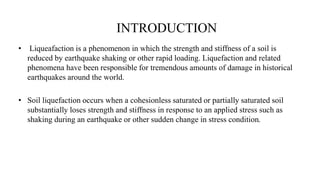
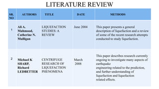
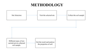
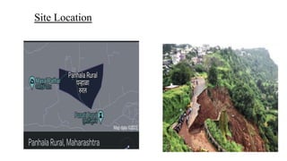
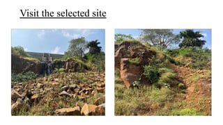
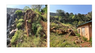
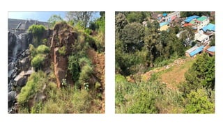
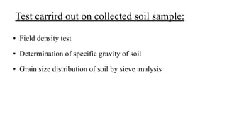
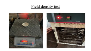
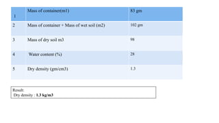
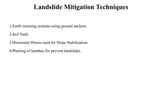
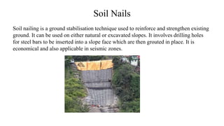
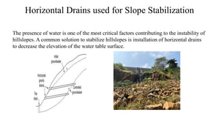
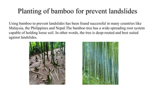
This document summarizes an analysis of soil liquefaction potential through field tests. It describes introducing the project, reviewing literature on the topic, describing the methodology, objectives, and site location. Field tests were conducted on soil samples collected from the site, including density, specific gravity, and grain size distribution tests. The results were analyzed to determine soil properties. Landslide mitigation techniques like ground anchors, soil nails, horizontal drains, and bamboo planting were discussed. The conclusion determined the soil's water content increases the slope's instability during monsoon season. References on the topic of soil liquefaction were also provided.
Identification Of Soil Erosion Prone Zones Using Geomatics Technology In Part...IJERA Editor
Soil erosion is the removal and subsequent loss of soil by the action of water, ice, wind and gravity. Soil erosion is a process that occurs naturally at a slow rate. The average natural geologic rate of soil erosion is approximately 0.2 tons per acre per year. Erosion is the process were by the earth or rock is loosened or dissolved and removed from any part of earth‟s surface. Geological erosion is the rate at which the catchment or land would normally be eroded without any disturbance by human activity. If man alters the natural system by means of various land use practices that is caused accelerated erosion. The present study area is covering Parts of North Arcot The area is lies between E78°30'-E78°45' lattitudes N12°15'-N12°30„. The total aerial extent of the study area is 720 sq.km. It falls in the survey of India Toposheet 58 L11 on 1:50,000 scale. The IRS – 1D satellite imagery data were subjected to different types of image enhancement techniques and soil erosion areas were mapped out and GIS databases were generated showing the soil erosion areas using Arc Map 9.1 version. GIS overlay function was executed between soil erosion prone areas and the various controlling variables and the area has been fragmented into a number of polygons of land segments depending upon the controlling variables. Finally, the remedial measures were suggested for each land segment according to the controlling variables.
Spatial Analysis of Soil and Water Quality in Tsunami AffectedAreas of Nagapa...IJERA Editor
In India, the natural disasters, especially the Tsunami in 2004 having exposed our unpreparedness, variability, diverse scientific, engineering, financial and also social processes. Vedaranyamtalukof Nagapattinam coastal region of Tamilnadu, India,was severely affected by Tsunami-2004. Due to its unique geological nature and climate conditions, the quality of soil and water resources was subjected to natural and synthetic changes. The recent efforts of prawn culture and saltpan in these areas also affect the natural resources. This study has revealed the present scenario of soil and water resources by analyzing their chemical parameters in the Tsunami affected areas after ten years of Tsunami-2004. For this study, soil samples (less than 30cm depth from land surface) and groundwater samples (from existing hand/bore pumps) were collected in the study area. It was observed from the analysis that the pH of soil was improved well and EC was lowered significantly except few places. Regarding the available N, P, K of soil, N was low, P and Kwere low to medium range. Further thepH,DO, Turbidity, Hardness,Cl and Mgof groundwater were within the permissible limit;EC and TDS were slight to moderate range for irrigation and drinking.The SAR is within the maximum allowable limit which inferred that groundwater can be used for irrigation without any risk.Thisspatial-temporal variability of soil and water parameters were mapped in GIS environment (Surfer ver. 9) and compared with pretsunami-2004 as well as ground truth scenario. Keeping these results, the soil is suitable for agriculture production. The natural flash flood has helped to reduce contamination of soil and water due to Tsunami-2004. However,due to alkaline in nature the quality of groundwater is not fit for drinking in some places but suitable for irrigation. Among the affected villages, Vedaranyam village has worst quality. This study also recommends suitable management strategies for sustainable development.
Determination of Some Mechanical And Hydraulic Properties Of Biu Clayey Soils...IJMER
International Journal of Modern Engineering Research (IJMER) is Peer reviewed, online Journal. It serves as an international archival forum of scholarly research related to engineering and science education.
Experiential Investigation on the Stabilization of Dispersive Soil with Limeijtsrd
The soils that are highly susceptible to erosion and containing high percentage of exchangeable sodium ions are called Dispersive Soils. In appearance, dispersive clays are like normal clays that are stable and somewhat resistant to erosion, but in reality they can be highly erosive and subject to severe damage or failure. Using dispersive clay soils in hydraulic structures, embankment dams, or other structures such as roadway, embankments can cause serious engineering problems if these soils are not stabilized and used appropriately. This problem is worldwide, and structural failures attributed to dispersive soils have occurred in many countries. This paper presents the stabilization of dispersive soil with lime. The soil sample is taken from Mandalay. Grain size distribution, Atterberg's limit test, compaction test, unconfined compressive strength UCS test and triaxial test are carried out to obtain the properties of soil. Type of studied soil classified by unified classification system is lean clay with sand. Crumb test is performed to know the dispersion degree of study soil. According to crumb test, the study soil is highly dispersive clay soil. Lime is used as stabilizing agent. The amount of lime used is 2 , 3 and 4 by dry weight of soil. The studied soil is mixed various contents of lime, and then crumb test is performed. At dispersive soil mixed with 4 of lime, there is no dispersion characteristic in soil. For stabilization of studied soil, 4 of lime is selected to investigate the improvement of strength in treated soil. The treated soil is performed compaction test, unconfined compression strength UCS test and triaxial test. Unconfined compression strength of treated soil at 4 lime is increased as 1.12 times that of natural soil. The shear strength of treated soil increases about 2 times than that of natural soil. The cohesion value of treated soil increases about 1.12 times and the angle of internal friction increases about 1.23 times than that of natural soil. Finally, it is concluded from this study that the lime treated soil is more resistant to erosion and the treated soil is more resistant to shear stress and lateral pressure. Soe Soe War | Nyein Nyein Thant "Experiential Investigation on the Stabilization of Dispersive Soil with Lime" Published in International Journal of Trend in Scientific Research and Development (ijtsrd), ISSN: 2456-6470, Volume-3 | Issue-5 , August 2019, URL: https://www.ijtsrd.com/papers/ijtsrd26658.pdfPaper URL: https://www.ijtsrd.com/engineering/civil-engineering/26658/experiential-investigation-on-the-stabilization-of-dispersive-soil-with-lime/soe-soe-war
The International Journal of Engineering and Science (The IJES)theijes
The International Journal of Engineering & Science is aimed at providing a platform for researchers, engineers, scientists, or educators to publish their original research results, to exchange new ideas, to disseminate information in innovative designs, engineering experiences and technological skills. It is also the Journal's objective to promote engineering and technology education. All papers submitted to the Journal will be blind peer-reviewed. Only original articles will be published.
The papers for publication in The International Journal of Engineering& Science are selected through rigorous peer reviews to ensure originality, timeliness, relevance, and readability
Research Inventy : International Journal of Engineering and Scienceresearchinventy
Research Inventy : International Journal of Engineering and Science is published by the group of young academic and industrial researchers with 12 Issues per year. It is an online as well as print version open access journal that provides rapid publication (monthly) of articles in all areas of the subject such as: civil, mechanical, chemical, electronic and computer engineering as well as production and information technology. The Journal welcomes the submission of manuscripts that meet the general criteria of significance and scientific excellence. Papers will be published by rapid process within 20 days after acceptance and peer review process takes only 7 days. All articles published in Research Inventy will be peer-reviewed.
Relationship with the Degree of Saturation of the Swelling StrainIJERA Editor
Expansive soil in SokooNgawi East Java often gives problems in the building stability. This research aims to study the properties of the soil in the area that mainly related to changes in moisture content in particular the influence of the degree of saturation of the swelling strain. Swelling tests were performed on disturbed soil by means of oedometer at 6.9 kPa overburden pressure. Initial moisture contents used were varied from 15.04% to 42.88%. Swelling strain was measured using overburden pressure 6.9 kPa and swelling pressure obtained from the pressure required to return the sample to the original condition. The test results show that for initial moisture content 15.04 % , γd= 1.471 gr/cm ³,S = 50.70 % the maximum swelling strain were 38.04% and swelling pressure was 2392 kPa. The initial moisture content 42.88%, γd= 0.926 gr / cm ³, S = 65.26 % the minimum swelling strain was 1.68 % and swelling pressure was 34 kPa.
The properties and potentials of soils of Liman Katagum (LK) in Bauchi State were assessed for both rainfed and irrigated crop production. Six soil mapping units were identified. The soils were moderately deep to very deep (93 – 163cm), except for exposed petroplinthite in some part of land unit LK 2. Soil pH ranged between 4.7 and 8.4, and was rated moderately acid to moderately alkaline. The soils were characterized by moderate fertility status. Improved management techniques were suggested for sustainable use of the land to improve farmers’ economy in the area. Assessment of the land potential showed that land units LK 3, LK 5 and LK6 (47.5%; 9.975ha) were moderately suitable (S2) and LK 1 and LK 4 (27.5%; 5.775ha) marginally suitable (S3) for rainfed crop production. For irrigated crop production, land units; LK 3, LK 4, LK 5 and LK 6 (51.43%; 10.8ha) were potentially moderately suitable (S2) and Land unit LK 1 (23.57%; 4.95ha) marginally suitable (S3). Land unit LK 2 constituting 25% (5.25ha) of the land was not potentially suitable (N2) for either rainfed or irrigated agriculture.
International Journal of Engineering Research and Applications (IJERA) is an open access online peer reviewed international journal that publishes research and review articles in the fields of Computer Science, Neural Networks, Electrical Engineering, Software Engineering, Information Technology, Mechanical Engineering, Chemical Engineering, Plastic Engineering, Food Technology, Textile Engineering, Nano Technology & science, Power Electronics, Electronics & Communication Engineering, Computational mathematics, Image processing, Civil Engineering, Structural Engineering, Environmental Engineering, VLSI Testing & Low Power VLSI Design etc.
Identification of Groundwater Potential Zones in Vaippar Basin, Tamil Nadu, I...SagarChougule11
Groundwater is prominent part of the earth’s fresh water as well as main source of drinking water and survival source for many lives on earth. Groundwater potential zone identification can be done using advanced as well as recently developed geospatial technology such as Remote Sensing and GIS. GIS technology is useful for capturing, storing, and analyzing spatial data with the help of computer programming techniques. Here in identification of groundwater potential zone using of spatial elements which are related for infiltration of water into ground. For the groundwater potential zone analysis using of spatial layers like geology, geomorphology, rainfall, lineament, land use/land cover, drainage density, soil texture, soil depth etc.
International Journal of Engineering Research and Development (IJERD)IJERD Editor
journal publishing, how to publish research paper, Call For research paper, international journal, publishing a paper, IJERD, journal of science and technology, how to get a research paper published, publishing a paper, publishing of journal, publishing of research paper, reserach and review articles, IJERD Journal, How to publish your research paper, publish research paper, open access engineering journal, Engineering journal, Mathemetics journal, Physics journal, Chemistry journal, Computer Engineering, Computer Science journal, how to submit your paper, peer reviw journal, indexed journal, reserach and review articles, engineering journal, www.ijerd.com, research journals,
yahoo journals, bing journals, International Journal of Engineering Research and Development, google journals, hard copy of journal,
Hybrid optimization of pumped hydro system and solar- Engr. Abdul-Azeez.pdffxintegritypublishin
Advancements in technology unveil a myriad of electrical and electronic breakthroughs geared towards efficiently harnessing limited resources to meet human energy demands. The optimization of hybrid solar PV panels and pumped hydro energy supply systems plays a pivotal role in utilizing natural resources effectively. This initiative not only benefits humanity but also fosters environmental sustainability. The study investigated the design optimization of these hybrid systems, focusing on understanding solar radiation patterns, identifying geographical influences on solar radiation, formulating a mathematical model for system optimization, and determining the optimal configuration of PV panels and pumped hydro storage. Through a comparative analysis approach and eight weeks of data collection, the study addressed key research questions related to solar radiation patterns and optimal system design. The findings highlighted regions with heightened solar radiation levels, showcasing substantial potential for power generation and emphasizing the system's efficiency. Optimizing system design significantly boosted power generation, promoted renewable energy utilization, and enhanced energy storage capacity. The study underscored the benefits of optimizing hybrid solar PV panels and pumped hydro energy supply systems for sustainable energy usage. Optimizing the design of solar PV panels and pumped hydro energy supply systems as examined across diverse climatic conditions in a developing country, not only enhances power generation but also improves the integration of renewable energy sources and boosts energy storage capacities, particularly beneficial for less economically prosperous regions. Additionally, the study provides valuable insights for advancing energy research in economically viable areas. Recommendations included conducting site-specific assessments, utilizing advanced modeling tools, implementing regular maintenance protocols, and enhancing communication among system components.
Explore the innovative world of trenchless pipe repair with our comprehensive guide, "The Benefits and Techniques of Trenchless Pipe Repair." This document delves into the modern methods of repairing underground pipes without the need for extensive excavation, highlighting the numerous advantages and the latest techniques used in the industry.
Learn about the cost savings, reduced environmental impact, and minimal disruption associated with trenchless technology. Discover detailed explanations of popular techniques such as pipe bursting, cured-in-place pipe (CIPP) lining, and directional drilling. Understand how these methods can be applied to various types of infrastructure, from residential plumbing to large-scale municipal systems.
Ideal for homeowners, contractors, engineers, and anyone interested in modern plumbing solutions, this guide provides valuable insights into why trenchless pipe repair is becoming the preferred choice for pipe rehabilitation. Stay informed about the latest advancements and best practices in the field.
Final project report on grocery store management system..pdfKamal Acharya
In today’s fast-changing business environment, it’s extremely important to be able to respond to client needs in the most effective and timely manner. If your customers wish to see your business online and have instant access to your products or services.
Online Grocery Store is an e-commerce website, which retails various grocery products. This project allows viewing various products available enables registered users to purchase desired products instantly using Paytm, UPI payment processor (Instant Pay) and also can place order by using Cash on Delivery (Pay Later) option. This project provides an easy access to Administrators and Managers to view orders placed using Pay Later and Instant Pay options.
In order to develop an e-commerce website, a number of Technologies must be studied and understood. These include multi-tiered architecture, server and client-side scripting techniques, implementation technologies, programming language (such as PHP, HTML, CSS, JavaScript) and MySQL relational databases. This is a project with the objective to develop a basic website where a consumer is provided with a shopping cart website and also to know about the technologies used to develop such a website.
This document will discuss each of the underlying technologies to create and implement an e- commerce website.
About
Indigenized remote control interface card suitable for MAFI system CCR equipment. Compatible for IDM8000 CCR. Backplane mounted serial and TCP/Ethernet communication module for CCR remote access. IDM 8000 CCR remote control on serial and TCP protocol.
• Remote control: Parallel or serial interface.
• Compatible with MAFI CCR system.
• Compatible with IDM8000 CCR.
• Compatible with Backplane mount serial communication.
• Compatible with commercial and Defence aviation CCR system.
• Remote control system for accessing CCR and allied system over serial or TCP.
• Indigenized local Support/presence in India.
• Easy in configuration using DIP switches.
Technical Specifications
Indigenized remote control interface card suitable for MAFI system CCR equipment. Compatible for IDM8000 CCR. Backplane mounted serial and TCP/Ethernet communication module for CCR remote access. IDM 8000 CCR remote control on serial and TCP protocol.
Key Features
Indigenized remote control interface card suitable for MAFI system CCR equipment. Compatible for IDM8000 CCR. Backplane mounted serial and TCP/Ethernet communication module for CCR remote access. IDM 8000 CCR remote control on serial and TCP protocol.
• Remote control: Parallel or serial interface
• Compatible with MAFI CCR system
• Copatiable with IDM8000 CCR
• Compatible with Backplane mount serial communication.
• Compatible with commercial and Defence aviation CCR system.
• Remote control system for accessing CCR and allied system over serial or TCP.
• Indigenized local Support/presence in India.
Application
• Remote control: Parallel or serial interface.
• Compatible with MAFI CCR system.
• Compatible with IDM8000 CCR.
• Compatible with Backplane mount serial communication.
• Compatible with commercial and Defence aviation CCR system.
• Remote control system for accessing CCR and allied system over serial or TCP.
• Indigenized local Support/presence in India.
• Easy in configuration using DIP switches.
Hierarchical Digital Twin of a Naval Power SystemKerry Sado
A hierarchical digital twin of a Naval DC power system has been developed and experimentally verified. Similar to other state-of-the-art digital twins, this technology creates a digital replica of the physical system executed in real-time or faster, which can modify hardware controls. However, its advantage stems from distributing computational efforts by utilizing a hierarchical structure composed of lower-level digital twin blocks and a higher-level system digital twin. Each digital twin block is associated with a physical subsystem of the hardware and communicates with a singular system digital twin, which creates a system-level response. By extracting information from each level of the hierarchy, power system controls of the hardware were reconfigured autonomously. This hierarchical digital twin development offers several advantages over other digital twins, particularly in the field of naval power systems. The hierarchical structure allows for greater computational efficiency and scalability while the ability to autonomously reconfigure hardware controls offers increased flexibility and responsiveness. The hierarchical decomposition and models utilized were well aligned with the physical twin, as indicated by the maximum deviations between the developed digital twin hierarchy and the hardware.
Water scarcity is the lack of fresh water resources to meet the standard water demand. There are two type of water scarcity. One is physical. The other is economic water scarcity.
Overview of the fundamental roles in Hydropower generation and the components involved in wider Electrical Engineering.
This paper presents the design and construction of hydroelectric dams from the hydrologist’s survey of the valley before construction, all aspects and involved disciplines, fluid dynamics, structural engineering, generation and mains frequency regulation to the very transmission of power through the network in the United Kingdom.
Author: Robbie Edward Sayers
Collaborators and co editors: Charlie Sims and Connor Healey.
(C) 2024 Robbie E. Sayers
1. Analysis Of Soil Liquefaction
Potential Through Field Tests-Based
Method.
2. ABOUT PROJECT
• Introduction
• Litreature Review
• Methodology
• Objective
• Site location
• Visit the site and collect the soil sample
• Different test carried out on soil sample and their results.
• Landslide Mitigation Techniques
• Conclusion
• Refrences
3. INTRODUCTION
• Liqueafaction is a phenomenon in which the strength and stiffness of a soil is
reduced by earthquake shaking or other rapid loading. Liquefaction and related
phenomena have been responsible for tremendous amounts of damage in historical
earthquakes around the world.
• Soil liquefaction occurs when a cohesionless saturated or partially saturated soil
substantially loses strength and stiffness in response to an applied stress such as
shaking during an earthquake or other sudden change in stress condition.
4. LITERATURE REVIEW
SR.
NO
AUTHORS TITLE DATE METHODS
1
Ali A.
Mahmood,
Catherine N.
Mulligan
LIQUEFACTION
STUDIES: A
REVIEW
June 2004 This paper presents a general
description of liquefaction and a review
of some of the recent research attempts
conducted to study liquefaction.
2 Michael K
SHARP,
Richard
LEDBETTER
CENTRIFUGE
RESEARCH OF
LIQUEFACTION
PHENOMENA
March
2008
This paper describes research currently
ongoing to investigate many aspects of
earthquake
engineering related to the prediction,
and further understanding of
liquefaction and liquefaction
related effects.
5. SR.
NO
AUTHOR TITLE DATE METHODS
3
Anbazhagan
P.
Liquefaction
Hazard Mapping
of Bangalore,
South India
April 2009 This paper presents identification and mapping of
vulnerable and safe zones for liquefaction hazard.
About 850 bore logs data collected from
geotechnical investigation reports have been used
to estimate the liquefaction factor of safety for
Bangalore Mahanagara palike (BMP) area of about
220 km2.
4
Shojiro
Kataoka
Effect of
earthquake ground
motions on soil
liquefaction
14 October
2012
In this paper presents the strong motion observation
data obtained on the liquefied and the non-liquefied
grounds and raises
preliminary discussions on the mechanism of soil
liquefaction based on this data.
6. SR.N
O
AUTHOR TITLE DATE METHODS
5
Burak
Yegil
Investigation of Soil
Liquefaction Potential
around
Efteni Lake in Duzce
Turkey: Using Empirical
Relationships
between Shear Wave
Velocity and SPT Blow
Count (N)
July 2014
Evaluation of the liquefaction potential of a
liquefaction-prone area is important for
geotechnical earthquake engineering, both for
assessment for site selection and for planning
and new constructions.
6
Manoj
Jain,R.S.
Ojha
Soil Liquefaction
Effects on R.C.C. Piles
December
2014
The behavior of foundations during
earthquakes is often dictated by the response
of its supporting soil due to the ground
shaking.
7. SR.NO AUTHOR TITLE DATE METHODS
7 Zhixiong
Chen,Anthony
Teck Chee Goh .
Soil Liquefaction
Assessment Using Soft
ComputingApproaches
Based on Capacity
Energy Concept
21 August
2020 • Machine Learning
Methodology:
1. Ridge Regression
Algorithm
2. Lasso and LassoCV
Algorithm
3. Random Forest
Regression Algorithm
8. OBJECTIVE
1. To determine the soil properties.
2. To improve the strenghth of soil.
3. Apply suitable Mitigation techniques.
9. METHODOLOGY
Site Selection Visit the selected site Collect the soil sample
Different types of test
carried out on collected
soil sample.
Get the result and analyse
the properties of soil.
14. Test carrird out on collected soil sample:
• Field density test
• Determination of specific gravity of soil
• Grain size distribution of soil by sieve analysis
16. 1
Mass of container(m1) 83 gm
2 Mass of container + Mass of wet soil (m2) 102 gm
3 Mass of dry soil m3 98
4 Water content (%) 28
5 Dry density (gm/cm3) 1.3
Result:
Dry density : 1.3 kg/m3
18. Sr no Observation number 1 2
1 Weight of pycnometer (w1 g) 663 662
2 weight of pycnometer+ dry soil (w2g) 863 863
3 Weight of pycnometer + dry soil +Water at tempretrure 1632 1630
4 weight of pycnometer +water at tempreture 1539 1539
5 Specific gravity G 1.86 1.82
Result:
Specific gravity of given soil: 1.84 (mean)
19. Result:
1. The given soil sample is : Fine Grained Soil
2. Coefficient of curveture (Cc)= 1
3. Uniformity coefficient(Cu)= 1
Sieve Sizes(mm) Mass of soil retained
(gms)
% of soil retained (%) Cumulative % of soil
retained (%)
% of soil passing (%)
4.75 342 34.2 34.2 65.8
2.36 175 17.5 51.7 48.3
1.18 165 16.5 68.2 31.8
600 129 12.9 81.1 18.9
4.25 045 4.5 85.6 14.4
300 038 3.8 89.4 10.6
150 056 5.6 95 5
75 030 3.0 98 2.7
Pan 002 2.0 100 0
20. Landslide Mitigation Techniques
1.Earth retaining systems using ground anchors
2.Soil Nails
3.Horizontal Drains used for Slope Stabilization
4.Planting of bamboo for prevent landslides
21. Earth retaining systems using ground anchors
• Common applications of earth retaining systems using ground anchors include
soldier pile walls with anchors, sheet pile walls with anchors, diaphragm walls with
anchors, and secant pile walls with anchors.
Fig. Retaining wall
22. Soil Nails
Soil nailing is a ground stabilisation technique used to reinforce and strengthen existing
ground. It can be used on either natural or excavated slopes. It involves drilling holes
for steel bars to be inserted into a slope face which are then grouted in place. It is
economical and also applicable in seismic zones.
23. Horizontal Drains used for Slope Stabilization
The presence of water is one of the most critical factors contributing to the instability of
hillslopes. A common solution to stabilize hillslopes is installation of horizontal drains
to decrease the elevation of the water table surface.
24. Planting of bamboo for prevent landslides
Using bamboo to prevent landslides has been found successful in many countries like
Malaysia, the Philippines and Nepal.The bamboo tree has a wide-spreading root system
capable of holding loose soil. In other words, the tree is deep-rooted and best suited
against landslides.
25. Conclusion
1.Water content of soil is suddenly increases due to heavy rainfall in less time , average
water content is about 39% and soil is latcratic type , having high to moderate
permeability due to this water percolate into soil and soil become highly saturated and
unstable and flows down-word.
2.From tha basic survey , due to absence of gutters and drainage media percolated water
does not have way to drain of and water remains as it is in soil.
3.By comparing the factor of safety for both situation we conclude that in monsoon
seasaon this slope very unstable and dangerous.
26. Refrences
1. Manoj Jain,R.S.Ojha (December 2014 ) , Soil Liquefaction Effects on R.C.C. Piles.
2. Burak Yegil (1 July 2014) , Investigation of Soil Liquefaction Potential around Efteni Lake
in Duzce Turkey: Using Empirical Relationships between Shear Wave Velocity and SPT Blow Count(N).
3. Shojiro Kataoka (1 December 2012) , Effect of earthquake ground motions on soil
liquefaction.
4. Ali A. Mahmood (5 June 2002) , Liquefaction studies: A review .
5. Anthony Teck Chee Goh (21 August 2020) , Soil Liquefaction Assessment Using Soft
Computing Approaches Based on Capacity Energy Concept.