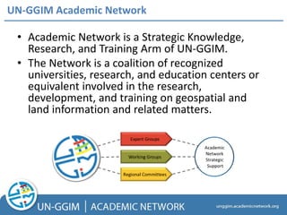
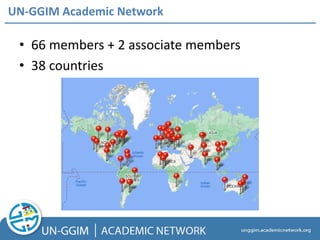
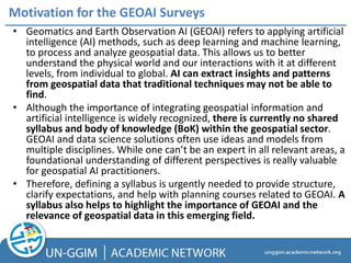
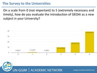
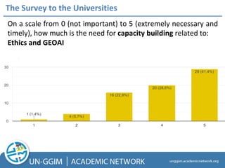
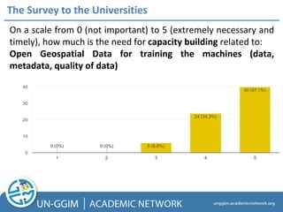
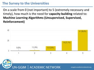
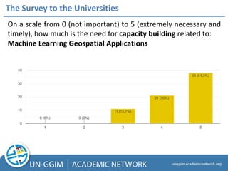
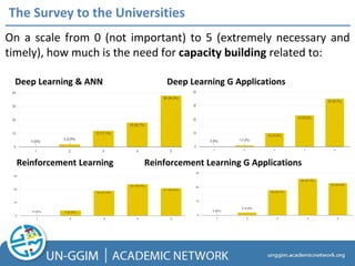
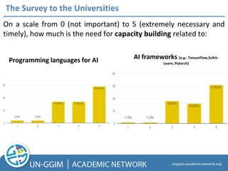
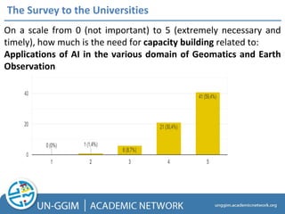
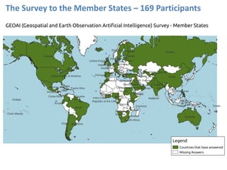
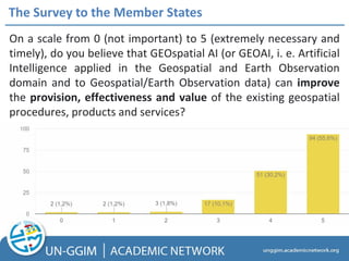
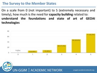
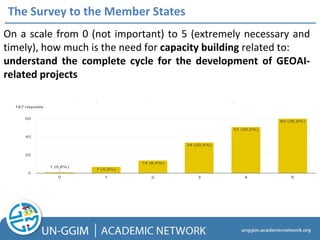
GEOAI: Opportunities and
Challenges
The outcome of the two surveys
of the UN GGIM AN
Prof. Maria Antonia Brovelli
Chair of the UN-GGIM Academic Network
Politecnico di Milano
on behalf of the UN GGIM AN Executive Board (Songnian Li, Ivana Ivanova)
Monday, 31 July 2023, 15:00 - 17:00
Conference Room A (Conference bldg.)
United Nations Headquarters, New York
• Academic Network is a Strategic Knowledge,
Research, and Training Arm of UN-GGIM.
• The Network is a coalition of recognized
universities, research, and education centers or
equivalent involved in the research,
development, and training on geospatial and
land information and related matters.
UN-GGIM Academic Network
• Promote and foster collaboration between universities
and research groups.
• Encouraging members to undertake work that
contributes to the Sustainable Development Goals of
the UN.
• Forum of geospatial academics and researchers with
the objective to advance competencies and
qualifications needed for the UN-GGIM.
• Communication platform for member countries to bring
to the Network’s attention their key problems, needs,
and areas of research.
• Capacity building and developing an inventory of
international education programs open to and
recommended for UN-GGIM actors.
UN-GGIM Academic Network
UN-GGIM Academic Network Executive Committee
UN-GGIM Academic Network Advisory Board
UN-GGIM Academic Network
• 66 members + 2 associate members
• 38 countries
• Geomatics and Earth Observation AI (GEOAI) refers to applying artificial
intelligence (AI) methods, such as deep learning and machine learning,
to process and analyze geospatial data. This allows us to better
understand the physical world and our interactions with it at different
levels, from individual to global. AI can extract insights and patterns
from geospatial data that traditional techniques may not be able to
find.
• Although the importance of integrating geospatial information and
artificial intelligence is widely recognized, there is currently no shared
syllabus and body of knowledge (BoK) within the geospatial sector.
GEOAI and data science solutions often use ideas and models from
multiple disciplines. While one can’t be an expert in all relevant areas, a
foundational understanding of different perspectives is really valuable
for geospatial AI practitioners.
• Therefore, defining a syllabus is urgently needed to provide structure,
clarify expectations, and help with planning courses related to GEOAI. A
syllabus also helps to highlight the importance of GEOAI and the
relevance of geospatial data in this emerging field.
Motivation for the GEOAI Surveys
• On the other hand, providing a body of knowledge in
GEOAI is crucial to establishing a common language and
understanding of key concepts, principles, and
techniques.
• This promotes effective communication and collaboration
among researchers, practitioners, and stakeholders in this
field.
• It also promotes best practices in the collection, analysis,
and interpretation of geospatial data and their integration
with AI techniques.
• The curriculum should be an integrative framework to
prepare the next generation of students and GEOAI
professionals to tackle complex challenges that can only be
solved with a holistic and interdisciplinary approach like
GEOAI.
Motivation for the GeoAI Surveys
• Such a body of knowledge would enable further
innovation and creativity in the development of new
techniques, tools, and applications, leading to more
breakthroughs in this field.
• Most importantly, it supports education and training
programs by providing a framework for curriculum
development and assessment.
• Finally, a body of knowledge facilitates decision-making in
policy, planning, and management, allowing decision-
makers to use geospatial data and AI techniques to
address complex social, economic, and environmental
challenges in a more effective and efficient manner.
Motivation for the GeoAI Surveys
The Survey to the Universities – 70 Participants
The Survey to the Universities
In which
program(s) in your
university the
GEOAI courses are
offered?
The Survey to the Universities
On a scale from 0 (not important) to 5 (extremely necessary and
timely), how do you evaluate the introduction of GEOAI as a new
subject in your University?
The Survey to the Universities
On a scale from 0 (not important) to 5 (extremely necessary and
timely), how much is the need for capacity building related to:
Ethics and GEOAI
The Survey to the Universities
On a scale from 0 (not important) to 5 (extremely necessary and
timely), how much is the need for capacity building related to:
Open Geospatial Data for training the machines (data,
metadata, quality of data)
The Survey to the Universities
On a scale from 0 (not important) to 5 (extremely necessary and
timely), how much is the need for capacity building related to:
Machine Learning Algorithms (Unsupervised, Supervised,
Reinforcement)
The Survey to the Universities
On a scale from 0 (not important) to 5 (extremely necessary and
timely), how much is the need for capacity building related to:
Machine Learning Geospatial Applications
The Survey to the Universities
On a scale from 0 (not important) to 5 (extremely necessary and
timely), how much is the need for capacity building related to:
Reinforcement Learning Reinforcement Learning G Applications
Deep Learning & ANN Deep Learning G Applications
The Survey to the Universities
Programming languages for AI AI frameworks (e.g.: TensorFlow,Scikit-
Learn, Pytorch)
On a scale from 0 (not important) to 5 (extremely necessary and
timely), how much is the need for capacity building related to:
The Survey to the Universities
On a scale from 0 (not important) to 5 (extremely necessary and
timely), how much is the need for capacity building related to:
Applications of AI in the various domain of Geomatics and Earth
Observation
The Survey to the Universities
On a scale from 0 (not important) to 5 (extremely necessary and
timely), how much is the need for capacity building related to:
GEOAI trustworthiness
GEOAI Performance & Reliability GEOAI Uncertainty
Quantification
• “Use of cloud platforms available i.e. GEE”
• “How to choose the best ML methods for a particular task/problem.”
• “GIT”
• “I feel Data Privacy and Licensing of Geospatial Information”
• “GIS Applications in Urban Planning, our University teaches, we need to teach GeoAI in a
different manner. Our answers are based on the experience of teaching and
reception/reaction received by the students at large.”
• “AI in interrelationship mapping; AI in geospatial validation process”
• “Software Development”
• “providing proper metadata/documentation for GeoAI products (e.g. data, training data,
products, algorithms, workflows)”
• “Ethics”
• “A multi-disciplinary collaboration is required”
The Survey to the Universities: what was Missing?
The Survey to the Universities
The Survey to the Member States – 169 Participants
The Survey to the Member States
On a scale from 0 (not important) to 5 (extremely necessary and
timely), do you believe that GEOspatial AI (or GEOAI, i. e. Artificial
Intelligence applied in the Geospatial and Earth Observation
domain and to Geospatial/Earth Observation data) can improve
the provision, effectiveness and value of the existing geospatial
procedures, products and services?
On a scale from 0 (not important) to 5 (extremely necessary
and timely), how ready and prepared should the public sector
of your country be in managing and developing GEOAI-
related projects, products and services?
The Survey to the Member States
On a scale from 0 (not important) to 5 (extremely necessary and
timely), how much is the need for capacity building related to:
The Survey to the Member States
On a scale from 0 (not important) to 5 (extremely necessary and
timely), how much is the need for capacity building related to:
understand the foundations and state of art of GEOAI
technologies
On a scale from 0 (not important) to 5 (extremely necessary and
timely), how much is the need for capacity building related to:
understand the complete cycle for the development of GEOAI-
related projects
The Survey to the Member States
On a scale from 0 (not important) to 5 (extremely necessary and
timely), how much is the need for capacity building related to:
understand the complete cycle for the delivery of GEOAI-related
public services
The Survey to the Member States
On a scale from 0 (not important) to 5 (extremely necessary
and timely), how do you evaluate the introduction of GEOAI
as a new subject in universities?
AI For Good
AI For Good
GeoAI Education - YouTube
https://www.youtube.com/watch?
v=acHUM7vb8o4
AI For Good
AI For Good
AI For Good: Open Challenges
GeoAI Challenge - AI for Good (itu.int)
Thank you!
unggim.academicnetwork@gmail.com

Side Event 31 July - Academic Network.pdf

  • 1.
    GEOAI: Opportunities and Challenges Theoutcome of the two surveys of the UN GGIM AN Prof. Maria Antonia Brovelli Chair of the UN-GGIM Academic Network Politecnico di Milano on behalf of the UN GGIM AN Executive Board (Songnian Li, Ivana Ivanova) Monday, 31 July 2023, 15:00 - 17:00 Conference Room A (Conference bldg.) United Nations Headquarters, New York
  • 2.
    • Academic Networkis a Strategic Knowledge, Research, and Training Arm of UN-GGIM. • The Network is a coalition of recognized universities, research, and education centers or equivalent involved in the research, development, and training on geospatial and land information and related matters. UN-GGIM Academic Network
  • 3.
    • Promote andfoster collaboration between universities and research groups. • Encouraging members to undertake work that contributes to the Sustainable Development Goals of the UN. • Forum of geospatial academics and researchers with the objective to advance competencies and qualifications needed for the UN-GGIM. • Communication platform for member countries to bring to the Network’s attention their key problems, needs, and areas of research. • Capacity building and developing an inventory of international education programs open to and recommended for UN-GGIM actors. UN-GGIM Academic Network
  • 4.
    UN-GGIM Academic NetworkExecutive Committee
  • 5.
  • 6.
    UN-GGIM Academic Network •66 members + 2 associate members • 38 countries
  • 7.
    • Geomatics andEarth Observation AI (GEOAI) refers to applying artificial intelligence (AI) methods, such as deep learning and machine learning, to process and analyze geospatial data. This allows us to better understand the physical world and our interactions with it at different levels, from individual to global. AI can extract insights and patterns from geospatial data that traditional techniques may not be able to find. • Although the importance of integrating geospatial information and artificial intelligence is widely recognized, there is currently no shared syllabus and body of knowledge (BoK) within the geospatial sector. GEOAI and data science solutions often use ideas and models from multiple disciplines. While one can’t be an expert in all relevant areas, a foundational understanding of different perspectives is really valuable for geospatial AI practitioners. • Therefore, defining a syllabus is urgently needed to provide structure, clarify expectations, and help with planning courses related to GEOAI. A syllabus also helps to highlight the importance of GEOAI and the relevance of geospatial data in this emerging field. Motivation for the GEOAI Surveys
  • 8.
    • On theother hand, providing a body of knowledge in GEOAI is crucial to establishing a common language and understanding of key concepts, principles, and techniques. • This promotes effective communication and collaboration among researchers, practitioners, and stakeholders in this field. • It also promotes best practices in the collection, analysis, and interpretation of geospatial data and their integration with AI techniques. • The curriculum should be an integrative framework to prepare the next generation of students and GEOAI professionals to tackle complex challenges that can only be solved with a holistic and interdisciplinary approach like GEOAI. Motivation for the GeoAI Surveys
  • 9.
    • Such abody of knowledge would enable further innovation and creativity in the development of new techniques, tools, and applications, leading to more breakthroughs in this field. • Most importantly, it supports education and training programs by providing a framework for curriculum development and assessment. • Finally, a body of knowledge facilitates decision-making in policy, planning, and management, allowing decision- makers to use geospatial data and AI techniques to address complex social, economic, and environmental challenges in a more effective and efficient manner. Motivation for the GeoAI Surveys
  • 10.
    The Survey tothe Universities – 70 Participants
  • 11.
    The Survey tothe Universities
  • 12.
    The Survey tothe Universities In which program(s) in your university the GEOAI courses are offered?
  • 13.
    The Survey tothe Universities
  • 14.
    The Survey tothe Universities
  • 15.
    The Survey tothe Universities
  • 16.
    The Survey tothe Universities On a scale from 0 (not important) to 5 (extremely necessary and timely), how do you evaluate the introduction of GEOAI as a new subject in your University?
  • 17.
    The Survey tothe Universities On a scale from 0 (not important) to 5 (extremely necessary and timely), how much is the need for capacity building related to: Ethics and GEOAI
  • 18.
    The Survey tothe Universities On a scale from 0 (not important) to 5 (extremely necessary and timely), how much is the need for capacity building related to: Open Geospatial Data for training the machines (data, metadata, quality of data)
  • 19.
    The Survey tothe Universities On a scale from 0 (not important) to 5 (extremely necessary and timely), how much is the need for capacity building related to: Machine Learning Algorithms (Unsupervised, Supervised, Reinforcement)
  • 20.
    The Survey tothe Universities On a scale from 0 (not important) to 5 (extremely necessary and timely), how much is the need for capacity building related to: Machine Learning Geospatial Applications
  • 21.
    The Survey tothe Universities On a scale from 0 (not important) to 5 (extremely necessary and timely), how much is the need for capacity building related to: Reinforcement Learning Reinforcement Learning G Applications Deep Learning & ANN Deep Learning G Applications
  • 22.
    The Survey tothe Universities Programming languages for AI AI frameworks (e.g.: TensorFlow,Scikit- Learn, Pytorch) On a scale from 0 (not important) to 5 (extremely necessary and timely), how much is the need for capacity building related to:
  • 23.
    The Survey tothe Universities On a scale from 0 (not important) to 5 (extremely necessary and timely), how much is the need for capacity building related to: Applications of AI in the various domain of Geomatics and Earth Observation
  • 24.
    The Survey tothe Universities On a scale from 0 (not important) to 5 (extremely necessary and timely), how much is the need for capacity building related to: GEOAI trustworthiness GEOAI Performance & Reliability GEOAI Uncertainty Quantification
  • 25.
    • “Use ofcloud platforms available i.e. GEE” • “How to choose the best ML methods for a particular task/problem.” • “GIT” • “I feel Data Privacy and Licensing of Geospatial Information” • “GIS Applications in Urban Planning, our University teaches, we need to teach GeoAI in a different manner. Our answers are based on the experience of teaching and reception/reaction received by the students at large.” • “AI in interrelationship mapping; AI in geospatial validation process” • “Software Development” • “providing proper metadata/documentation for GeoAI products (e.g. data, training data, products, algorithms, workflows)” • “Ethics” • “A multi-disciplinary collaboration is required” The Survey to the Universities: what was Missing?
  • 26.
    The Survey tothe Universities
  • 27.
    The Survey tothe Universities
  • 28.
    The Survey tothe Member States – 169 Participants
  • 29.
    The Survey tothe Member States On a scale from 0 (not important) to 5 (extremely necessary and timely), do you believe that GEOspatial AI (or GEOAI, i. e. Artificial Intelligence applied in the Geospatial and Earth Observation domain and to Geospatial/Earth Observation data) can improve the provision, effectiveness and value of the existing geospatial procedures, products and services?
  • 30.
    On a scalefrom 0 (not important) to 5 (extremely necessary and timely), how ready and prepared should the public sector of your country be in managing and developing GEOAI- related projects, products and services? The Survey to the Member States
  • 31.
    On a scalefrom 0 (not important) to 5 (extremely necessary and timely), how much is the need for capacity building related to: The Survey to the Member States On a scale from 0 (not important) to 5 (extremely necessary and timely), how much is the need for capacity building related to: understand the foundations and state of art of GEOAI technologies
  • 32.
    On a scalefrom 0 (not important) to 5 (extremely necessary and timely), how much is the need for capacity building related to: understand the complete cycle for the development of GEOAI- related projects The Survey to the Member States
  • 33.
    On a scalefrom 0 (not important) to 5 (extremely necessary and timely), how much is the need for capacity building related to: understand the complete cycle for the delivery of GEOAI-related public services The Survey to the Member States
  • 34.
    The Survey tothe Member States On a scale from 0 (not important) to 5 (extremely necessary and timely), how do you evaluate the introduction of GEOAI as a new subject in universities?
  • 35.
  • 36.
    AI For Good GeoAIEducation - YouTube https://www.youtube.com/watch? v=acHUM7vb8o4
  • 37.
  • 38.
  • 39.
    AI For Good:Open Challenges
  • 40.
    GeoAI Challenge -AI for Good (itu.int)
  • 41.