1) Many African oil operators are focusing on improving recovery rates and extending the life of existing fields due to fluctuations in oil prices and declining drilling activity. Cost containment has also become a key focus.
2) 3D reservoir modeling is playing an important role in development decisions and mapping reservoir behavior to optimize field lifecycles and production. Challenges include seismic interpretation, rapid model updating, and strengthening reservoir modeling skills.
3) New technologies like model-driven interpretation and multi-realization workflows allow for faster, more accurate incorporation of data and uncertainties into integrated models, facilitating improved field development planning and production forecasts. This contributes to extending field life in Africa.
Runoff modelling using hec hms for rural watershedEditorIJAERD
Due to climate change it is very essential to do hydrological modelling. Reliable models are essential for planning,
developmental works, prediction and safety of the population. Hydrological models are used to determine catchment
discharge/flow through an efficient way. HEC-HM (Hydrological engineering centre Hydrological modelling system) is
one of hydrological modelling tool developed by United States army corps of engineer (USACE) for event as well as for
continuous simulations. Models, especially continuous simulations are useful for future predictions of stream flow due to
land-use changes or extreme events phenomenon. In this study continuous hydrologic modellingwas carried out using
HEC HMS modelling tool.
Deficit and Constant Loss methods with Clark transform methods were selected. The calibrated model (period
1986-1988) was validated with data set of the period of 2009-2013. Study concluded that the model recommended and
can be used for stated River as decision support tool in the design and operation.
Sensitivity of AERMOD in Modeling Fugitive Dust Emission Sources BREEZE Software
"This paper explores common presumptions about fugitive source modeling techniques by examining the sensitivity of predicted PM ambient concentrations to the choice of model
(AERMOD versus ISCST3), changes in source representation (volume versus area source), and variations in chosen source dimensions. "
GeoArabia, Vol. 4, No. 2, 1999
Gulf PetroLink, Bahrain
Best Practices in 3-D Land Seismic Acquisition in the Middle East and North Africa: Cost-Effective Acquisition in a Low Oil Price Environment
(C)Neil McMahon, Arthur D. Little Management Consultants,
(C)Kees Ruitenbeek*, Petroleum Development Oman,
(C)Jan Wams, Shell Compania Argentina de Petroleo S.A.,
(C)Steve Slawson, Continuum Resources International Corporation
(C)GeoArabia, Vol. 4, No. 2, 1999 Gulf PetroLink, Bahrain
INTEGRATING CLIMATE CONSIDERATIONS INTO ASSET MANAGEMENT AT MAINEDOT - GSMSum...GrowSmart Maine
Why plan for growth and change, when it seems so much easier to simply react?
When there is a distinct and shared vision for your community - when residents, businesses and local government anticipate a sustainable town with cohesive and thriving neighborhoods - you have the power to conserve your beautiful natural spaces, enhance your existing downtown or Main Street, enable rural areas to be productive and prosperous, and save money through efficient use of existing infrastructure.
This is the dollars and sense of smart growth.
Success is clearly visible in Maine, from the creation of a community-built senior housing complex and health center in Fort Fairfield to conservation easements creating Forever Farms to Rockland's revitalized downtown. Communities have options. We have the power to manage our own responses to growth and change.
After all, “Planning is a process of choosing among those many options. If we do not choose to plan, then we choose to have others plan for us.” - Richard I. Winwood
And in the end, this means that our children and their children will choose to make Maine home and our economy will provide the opportunities to do so.
The Summit offers you a wonderful opportunity to be a part of the transformative change in Maine that we’ve seen these gatherings produce. We encourage you to consider the value of being actively involved in growing Maine’s economy and protecting the reasons we choose to live here.
Seismic Applications Throughout the Life of the Reservoir
(C) July 2002 Oilfield Review
Projects: Seismic Reservoir Characterizationusing avo inversion for reservoir characterization
Operators are getting more from their reservoirs by combining high-quality seismic
images with conventional reservoir data. Asset teams use this calibrated seismic
information to gain detailed knowledge of reservoir properties, allowing them to
reduce risk at every stage in the life of their prospects.
Trine Alsos
Alfhild Eide
Statoil
Trondheim, Norway
Donatella Astratti
Stephen Pickering
Gatwick, England
Marcelo Benabentos
Nader Dutta
Subhashis Mallick
George Schultz
Houston, Texas, USA
Lennert den Boer
Calgary, Alberta, Canada
Michael Livingstone
Aberdeen, Scotland
Michael Nickel
Lars Sønneland
Stavanger, Norway
Juergen Schlaf
Phillips Petroleum Company
Stavanger, Norway
Pascal Schoepfer
Petroleum Development Oman
Muscat, Sultanate of Oman
Mario Sigismondi
Juan Carlos Soldo
Pecom Energía de Pérez Companc SA
Neuquén, Argentina
Lars Kristian Strønen
Statoil
Bergen, Norway
For help in preparation of this article, thanks to Mike
Bahorich, Apache Corporation, Houston, Texas, USA; Lee
Bell, Laurence Darmon, Olav Holberg, John Waggoner and
Bob Will, Houston, Texas; Phil Christie, Cambridge, England;
Doug Evans, Malcolm Francis, Michael French, Bob
Godfrey, Kim Hughes and Stephen McHugo, Gatwick,
England; and Ray Pratt, Amerada Hess, Olso, Norway.
ECLIPSE, FrontSim, MultiWave Array and RFT (Repeat
Formation Tester) are marks of Schlumberger.
A study confined to the lower tapi basin in Gujarat, India to find out the primary causes for 2006 floods in Surat city. The study involves collection of topographical data from the local geological survey organization, rainfall data from meteorological department of india and the application of HEC-HMS software from US Army corps of engineers to identify the primary cause of the runoff.
Flood Risk Analysis for River Serio, Italy by using HECRAS & River 2DArshia Mousavi
In this study, we modeled River Serio (Italy) for the assessment of Flood Risk using different modelling software. River Serio is an Italian river that flows across Lombardy region, crossing the provinces of Bergamo and Cremona. It is 125 Kms long and flows into Adda at Bocca di Serio south of Crema. Using software like HEC-RAS and River 2D to model the river section at ordinary and peak flows to analyse the possibilities of Flood. Using Analytical Calculations assessed Sediments carried away from Upstream to Downstream. By this analysis able to figure our the area going to be flooded and also the transport capacity of the sediments and the amount of sediments that can be carried by the flood water. Evaluated the Results and obtained some of the precautionary measures to protect the area from Flood. Analysis were made for one dimensional model for ordinary and peak discharge on steady model and Unsteady flow using 200 years hydro-graph. Also two dimensional analysis was made for steady flow at peak discharge. The results of both the models are compared to analyse the situation of the water profile and made related observations. Finally we calculated the sediments that gets transported in the river serio & the discharge by which the sediments gets transported. Looking at the entire scenario of different models and performing sensitive analysis to understand the pattern of the flood that can take place at different intensity levels.
Software Used: HEC-RAS for 1 Dimensional Modelling, River-2D for 2 Dimensional Modelling.
IJRET : International Journal of Research in Engineering and Technology is an international peer reviewed, online journal published by eSAT Publishing House for the enhancement of research in various disciplines of Engineering and Technology. The aim and scope of the journal is to provide an academic medium and an important reference for the advancement and dissemination of research results that support high-level learning, teaching and research in the fields of Engineering and Technology. We bring together Scientists, Academician, Field Engineers, Scholars and Students of related fields of Engineering and Technology
HEC-RAS is a computer program that models the hydraulics of water flow through natural rivers and other channels. The program is one-dimensional, meaning that there is no direct modeling of the hydraulic effect of cross section shape changes, bends, and other two- and three-dimensional aspects of flow. The program was developed by the US Department of Defense, Army Corps of Engineers in order to manage the rivers, harbors, and other public works under their jurisdiction; it has found wide acceptance by many others since its public release in 1995.
ASFPM 2016: Applications of 2D Surface flow Modeling in the New HEC-RAS Versi...CDM Smith
Derek Etkin presented "Applications of 2D Surface flow Modeling in the New HEC-RAS Version 5.0" at the 2016 Association of State Floodplain Managers conference.
Hec ras flood modeling little river newburyportWilliam Mullen
This narrated PowerPoint presentation describes a HEC-RAS 2-D unsteady-flow flood model set up for the tidally-influenced Little River in Newburyport and Newbury, Massachusetts. It describes the steps in developing inputs to the HEC-RAS model including using HEC-HMS rainfall-runoff modeling and GIS in developing inputs to HEC-HMS. The HEC-RAS model was calibrated using the Mother's Day flood of May 2006. The HEC-RAS model may be used to evaluate impacts associated with proposed changes in culvert sizes or changing embankment elevations near or at problem flood areas and can also be used to determine the changes in river hydraulics associated with sea level rise and climate change.
Computational Model for Urban Growth Using Socioeconomic Latent ParametersPiyush Yadav
The work was presented at European Conference of Machine Learning (ECML-PKDD), 2018 and focused on modelling and predicting urban growth using remote sensing and socioeconomic data.
Using HEC-RAS to assess flash floods risk in arid regionsAhmed Saleh, Ph.D
Explain the utilization of HEC-RAS to two-dimensional simulation of flood wave propagation. also, show the application of ArcGis to draw flood risk maps.
Impact of Planning Decision Support Tools on Mining Operations ProfitabilitySchneider Electric
Changes in the mining industry business environment are leading to gradual changes in how the supply chain (from ore extraction at the mine to delivery at customer sites) is managed. Global demand is flattening and available supply is increasing. This means that complex planning business models that were developed in an era of supply “push” need to be altered to accommodate a market reality of demand driven “pull”. This white paper introduces a decision support methodology that results in reduced cost, improved throughput, enhanced quality, and increased profit.
A mathematical modeling proposal for a Multiple Tasks Periodic Capacitated Ar...IJERA Editor
The countless accidents and incidents occurred at dams at the last years, propelled the development of politics
related with dams safety. One of the strategies is related to the plan for instrumentation and monitoring of dams.
The monitoring demands from the technical team the reading of the auscultation data, in order to periodically
monitor the dam. The monitoring plan of the dam can be modeled as a problem of mathematical program of the
periodical capacitated arcs routing program (PCARP). The PCARP is considered as a generalization of the
classic problem of routing in capacitated arcs (CARP) due to two characteristics: 1) Planning period larger than
a time unity, as that vehicle make several travels and; 2) frequency of associated visits to the arcs to be serviced
over the planning horizon. For the dam's monitoring problem studied in this work, the frequent visits, along the
time horizon, it is not associated to the arc, but to the instrument with which is intended to collect the data.
Shows a new problem of Multiple tasks Periodic Capacitated Arc Routing Problem and its elaboration as an
exact mathematical model. The new main characteristics presented are: multiple tasks to be performed on each
edge or edges; different frequencies to accomplish each of the tasks; heterogeneous fleet; and flexibility for
more than one vehicle passing through the same edge at the same day. The mathematical model was
implemented and examples were generated randomly for the proposed model's validation.
International Journal of Engineering Research and Applications (IJERA) is an open access online peer reviewed international journal that publishes research and review articles in the fields of Computer Science, Neural Networks, Electrical Engineering, Software Engineering, Information Technology, Mechanical Engineering, Chemical Engineering, Plastic Engineering, Food Technology, Textile Engineering, Nano Technology & science, Power Electronics, Electronics & Communication Engineering, Computational mathematics, Image processing, Civil Engineering, Structural Engineering, Environmental Engineering, VLSI Testing & Low Power VLSI Design etc.
Simplifying stormwater design is costing us money - a short case studyAdam Berry
A short case study on some possible economic advantages of using numerical modelling versus simplified methods for local government authorities in areas such as large cross drainage structures. In light of very recent announcements on the AR&R releases, this also gives further merit in reducing the use of techniques such as the Rational Method
Changes in dam break hydrodynamic modelling practice - Suter et alStephen Flood
Abstract: Today, many organisations rely on hydrodynamic modelling to assess the consequences of dam break failure on downstream populations and infrastructure. The availability of finite volume shock-capturing schemes and flexible mesh schematisations in widely used software platforms imply that dam break modelling projects will be carried out differently in the future: Finite volume based platforms allow widespread application of shock-capturing methods and flexible mesh platforms can represent features in the study area more realistically and are more flexible thanks to varying mesh resolutions. Furthermore, the recent adoption of Graphics Processing Unit (GPU) technology in mainstream scientific and engineering computing will also significantly decrease computation times at relatively low cost.
This paper examines the application of finite volume, flexible mesh and GPU technologies to dam break modelling. One-dimensional (1D) modelling results are compared to those from two-dimensional (2D) finite difference and finite volume approaches. The results demonstrate that there are differences between modelling approaches and that the computational speeds of 2D simulations can be significantly reduced by the use of GPU processors.
All phosphoric acid concentration units suffer from fouling requiring frequent shutdowns, cleaning and start-up cycles. These cycles are time consuming. Any process and control improvement facilitating the operations can lead to significant increase on strong acid production. This study shows how dynamic simulation can be used to conduct engineering studies, operational studies and training simulators to optimize the operability of a greenfield phosphoric acid concentration unit. In order to perform this optimization, a first principle model predicting how process and associated control will respond as a function of time was created based on all plant’s engineering information. The model can be further combined to DCS graphics and field operated devices schematics to facilitate procedure testing. Constant pressure and constant temperature start-up procedures were tested in order to estimate which procedure minimizes time to concentrate acid from 25% to 50% P2O5. It was found that both procedures were equivalent in terms of time and energy consumption, but constant pressure strategy is simpler and safer, potentially leading to less human related losses. These procedures were performed executing step-by-step actions, allowing determining most frequent mistakes, any missing actions and improving the existing written procedure. Furthermore, the simulator allowed verifying equipment design, interlocks, control logic and identifying new control enhancement opportunity. In addition, many tools available with the dynamic simulator can be used for operator training purposes leading to potential operability gains.
Dynamic operator training simulators for sulphuric acid, phosphoric acid, and...Sergio Joao
Dynamic process simulators are widely used in the chemical and petrochemical industries for operator training, plant design, and optimization;but there is a lack of rigorous simulators in the phosphate fertilizer industry. Some of the many difficulties encountered in phosphate fertilizer simulation include: lack of knowledge of thermodynamic properties, presence of many phases (gas, liquid, and solids), high levels and variation of impurities in phosphate rock producing unknown effects, complexity in modeling particle size distribution, etc. Dynamic training simulators were successfully developed for sulphuric acid, phosphoric acid, and DAP production units of OCP Group’s Jorf Lasfar complex using a commercial simulation platform. A new thermodynamic property package was developed for sulphuric acid and oleum to correctly predict vapor pressure, density, enthalpy, and SO2 solubility. Also, a rotary drum granulator was developed to consider the reaction chemistry of DAP production and the stochastic nature of solids created. The granulator can accurately predict particle size distribution, moisture content, ammonia and dust losses, and gas/solid temperatures. It was shown that the simulators could precisely reproduce control room and field operations to model plant start-ups, emergency or normal shutdowns, process upsets, and normal operations.
Dynamic operator training simulators for sulphuric acid, phosphoric acid, and...
S11 ORA 4 2015 - Technology 03
1. Oil Review Africa Issue Four 2015
WW ITH THE CONTINUED fluctuations in oil and gas prices and the
decline in drilling activity, many African operators today are
focusing on improving recovery rates and extending life from
their existing fields.
Cost containment has also become a key driver at all levels of the industry.
In Algeria, for example, state energy company Sonatrach has demanded its
service providers cut their prices by up to 15 per cent as the OPEC member
country tries to ward off the impact of falling oil prices and reduce the US$23bn
a year it currently spends on service costs.
Alongside traditional EOR (Enhanced Oil Recovery) technologies, 3D
reservoir modeling is now playing a key role in guiding development decisions
at the outset of the field’s lifecycle.
3D reservoir modeling is the standard platform for the mapping,
understanding and predicting of reservoir behavior. By building a realistic
representation of the geometry of the reservoir, operators can accurately map out
fluid flows and volumes and make field development decisions that have a major
impact on the field’s lifecycle and production capabilities for years to come.
This article looks at three key elements and challenges behind reservoir
modeling in Africa today and how they are contributing to extending field life.
They include the seismic interpretation stage; the need for rapid model updating;
and the need to strengthen reservoir modeling skills throughout Africa.
Theseismicinterpretationstage
Many African prospects are still at the interpretation stage where the seismic
has been acquired but obstacles remain as to finding a cost effective means of
incorporating such data into the reservoir modeling workflow.
In some cases, the data might be challenging to interpret or changes might
need to be made to the interpretation to produce a geologically consistent
model. In other cases, the creation of a reservoir model or an accurate
prediction of volumes might be required as quickly as possible to help with
future field development plans.
There is also the need to understand and quantify uncertainties pertaining to
the geological data and reservoir descriptions. How operators achieve this can
have a major impact on field development and the lifetime of the field.
Too often, however, operators are faced with cumbersome and
bottleneck-ridden workflows at the seismic stage as well as an inherent
ambiguity in the data.
Such ambiguity can be down to a number of factors, such as limited seismic
resolution and quality, and constraints on velocity for depth conversion. The
ambiguity also increases rapidly as the interpreter moves away from control
points, such as well logs.
The result is that African operators have inadequate solutions for quantifying
geologic risk – especially as they move into more complex tectonic settings
and more economically marginal prospects.
Model-driveninterpretation
Against this backdrop, Emerson has developed a proven workflow known as
model-driven interpretation that allows users to build models directly from the
geophysical data. The workflow takes place within Emerson’s reservoir modeling
software, Roxar RMS.
With the workflow, users can set and collect uncertainty information
associated with an interpretation; easily and reversibly test geologic hypotheses;
and add more detail to the model as and when required.
The workflow involves a geologically consistent structural model being
created (and updated) every time the interpreter makes a measurement of a
subsurface feature. Uncertainty information is collected and paired with an
interpreted geologic feature (horizon, fault, etc) to create an uncertainty
envelope. Here, the interpretation is not merely a collection of control points,
but consists of the integrated geological representation of a structural model
that satisfies those measurements.
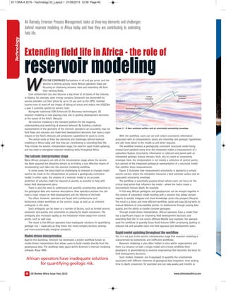
Figure 1 illustrates how measurement uncertainty is applied to a simple
seismic section where the interpreter measures a best estimate surface and an
associated uncertainty envelope.
The workflow is essentially purpose-driven where users can focus on the
critical data points that influence the model - where the faults create a
discontinuity horizon depth, for example.
In this way, African geologists and geophysicists can be brought together in
the context of subsurface model building with a solution that allows domain
experts to quickly integrate and share knowledge across the prospect lifecycle.
The result is a faster and more efficient workflow, quick and easy QCing (with no
manual deletions of unacceptable points), no bottlenecks through varying data
quality, and the ability to handle complex geologies.
Through model-driven interpretation, African operators have a model that
has a significant impact on improving field development decisions and
extending field life. In one recent offshore Middle East example, the operator
used the workflow to quantify Gross Rock Volume (GRV) uncertainty, leading to
reduced risk and valuable input into field appraisal and development plans.
Rapidmodelupdatingthroughouttheworkflow
Yet, it is not just at the seismic interpretation stage that reservoir modeling is
characterised by bottlenecks and inefficient workflows.
Reservoir modeling is also often hidden in silos within organisations and
there is a reliance on both a single model and a linear workflow (from
geophysics to geomodeling to reservoir engineering) that becomes the basis for
field development decisions.
Such models, however, are ill-equipped to quantify the uncertainties
associated with different elements of geological data (migration, time picking,
time to depth conversion, for example) and can take weeks and months to
Figure 1 - A best estimate surface and an associated uncertainty envelope.
African operators have inadequate solutions
for quantifying geologic risk.
Technology
40
Ali Ramady, Emerson Process Management, looks at three key elements and challenges
behind reservoir modeling in Africa today and how they are contributing to extending
field life.
Extending field life in Africa - the role of
reservoir modeling
www.oilreviewafrica.com
S11 ORA 4 2015 - Technology 03_Layout 1 01/09/2015 12:58 Page 40
2. move from initial model development to full flow simulation. There is also a
danger that some data and knowledge won’t transfer between disciplines with
too many future decisions based on just assumptions.
An alternative solution, however, is a multi-realisation workflow where the
modeling process is highly automated and flexible enough to incorporate new
data or concepts as soon as they are available and at any time. Such a workflow
should also utilise all available data throughout the workflow chain and enable
collaboration between disciplines.
That’s what has been achieved within Roxar RMS across the prospect
lifecycle. Not only is there closer integration between the geophysics and
geomodeling domains through model-driven interpretation but a more seamless
and flexible workflow right through to simulation via Emerson’s reservoir
engineering tool, Roxar Tempest.
The modeling workflow generates multiple and consistent models that can
capture uncertainties at all levels as well as the ability to incorporate new data,
such as newly drilled wells or new velocity models, as and when required. This, in
turn, is used by the simulation model for field development planning, well
placement and as input to economic analysis.
The latest version of Roxar RMS (Roxar RMS 2013.1) also includes the
further integration of fault uncertainty tools with structural modeling and 3D
gridding. This enables users to build fault uncertainty models in full and
investigate a wide variety of scenarios corresponding to the uncertainty in the
input data.
The ability to combine all available data as well as the easy updating
capabilities are of significant benefit to African operators – especially due to the
huge cost savings when working on existing models rather than creating new
models from scratch.
More accurate, consistent and integrated reservoir models, where data and
uncertainties can be propagated and linked, can subsequently have a key
influence on the future health and lifespan of the reservoir.
Today, many of the world’s highest recovery fields are modeled using Roxar
RMS – an example of how important it is to get the model ‘right’. Together,
such workflows enable the estimating of the impact of realistic structural
uncertainties on key outcomes, such as volumes in place and simulated
reserves, or their impact on well performance and net present value.
Thereservoirengineeringphase
Effective and robust reservoir modeling workflows are also crucial as input into
reservoir simulation and history matching. Emerson also provides a full range of
reservoir engineering and simulation tools not just for reservoir simulation but
also for the gridding and upscaling of geological models, visualisation of results,
assisted history matching and production uncertainty predictions.
In one example, US-based Norwest Corporation and its client needed a reliable
full-field simulation model to optimise high-pressure air injection and a horizontal
infill drilling programme for a tight reservoir in the Williston Basin in the US.
Through the adoption of Roxar Tempest, they achieved an excellent history
match, and used the model to optimise the timing and sequence of infill
drilling, and to convert producers to injectors.
Production and injection forecasts matched actuals at the end of the first
year - even during transient operations - and estimated recovery was more than
doubled. Such technologies can be applied to Africa as well.
Building&strengtheningskills–TheRoxarAcademy
Using reservoir modeling to help extend field life in Africa’s fields, however,
remains dependent on not just the technology but also the asset team
members.
To this end, there is a need in Africa to transform technicians, graduates and
asset team members - new to the latest reservoir modeling developments - into
highly productive and proficient team members. This must be achieved against
a backdrop of falling oil prices and a focus on cost containment.
With these issues in mind, Emerson has established the Roxar Training
Academy in Africa with the goal of increased reservoir modeling skills in-house.
Skills taught cover both general reservoir modeling skills and those specific
to Roxar RMS. In the former, for example, they might include advanced reservoir
modeling techniques, dynamic analysis, well planning and reservoir uncertainty,
and in relation to Roxar RMS, topics might include simulation grid design and
upscaling, well planning, and advanced structural and property modeling.
The results are essential skills for extending field life in Africa today.
Newchallenges,newapproaches
It is a fact that ‘easy oil’ is gone but significant oil deposits remain to be
explored and developed in Africa. However, this can only be achieved through
addressing the challenges seen in the current climate.
Technologies and approaches, such as Roxar RMS, enable faster, more
accurate, and more intuitive modeling.
This, in turn, helps geoscientists and reservoir engineers make better
decisions and ensure that the right field developments plans are put in place at
the outset. At a time in Africa where cost containment is key and oil prices
continue to struggle, it’s encouraging that technologies that focus on more
productive and longer-life fields in the future are still being advanced. ■
Oil Review Africa Issue Four 2015
Technology
42
The latest version of Roxar RMS (Roxar RMS 2013.1)
also includes the further integration of fault uncertainty
tools with structural modeling and 3D gridding.
The ability to combine all available
data as well as the easy updating
capabilities are of significant benefit to
African operators .
www.oilreviewafrica.com
S11 ORA 4 2015 - Technology 03_Layout 1 01/09/2015 12:58 Page 42