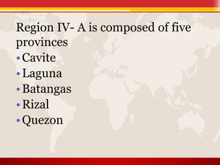
Region IV-A, also known as Calabarzon, is an administrative region of the Philippines located south of Metro Manila. It comprises five provinces: Cavite, Laguna, Batangas, Rizal, and Quezon, as well as the highly urbanized city of Lucena. Calabarzon has a population of over 14 million, making it the most populous region in the country. It has a predominantly flat terrain and is known for landmarks like Laguna de Bay, Taal Volcano, and Mount Makiling. The region has a strong economy focused on industry and manufacturing given its proximity to Metro Manila.


![HISTORY
On June 5, 1901, a convention was called on whether or not the province
of Manila should annex the province of Morong, which was found to be unable to be self-
sufficient as a province. Eventually, on June 11, Act No. 137of the First Philippine
Commission abolished Morong and created a new province, named after the Philippines'
national hero, Jose Rizal, who, coincidentally, was a native of Laguna. The new province
comprised 29 municipalities, 17 from Manila and 12 from Morong. In 1902, Macario Sakay, a
veteran Katipunan member, established the Tagalog Republic in the mountains of Rizal.
Ultimately, Sakay's Tagalog Republic ended in 1906 when he and his men were betrayed
under the guise of holding a national assembly aimed at the self-determination of the Filipino
people.
On September 7, 1946, the Third Philippine Republic enacted Republic Act No. 14,
which renamed the province of Tayabas to Quezon, in honor of Manuel Quezon. Quezon was
the second President of the Philippinesand a native of Baler (now part of Aurora). In 1951, the
northern part of Quezon became the sub-province Aurora, named after Quezon's wife.
On September 24, 1972, President Ferdinand Marcos enacted Presidential Decree
No. 1, which organized the provinces into 11 regions as part of Marcos' Integrated
Reorganization Plan.The IRP created Region IV, known as the Southern Tagalog region, and
was the largest region in the Philippines. At this time, Region IV consisted of Batangas, Cavite,
Laguna, Marinduque, Oriental Mindoro, Occidental Mindoro, Quezon, Rizal, Romblon,
and Palawan. In 1979, Aurora formally became a province independent of Quezon and was
also included in Region IV.[citation needed]
On May 17, 2002, President Gloria Macapagal-Arroyo signed Executive Order No.
103, which made reorganized to the Southern Tagalog region. Due to its size, Region IV was
split into two separate regions, Region IV-A (Calabarzon) and Region IV-B (Mimaropa).
Aurora was transferred to Region III, Central Luzon.The next year, Arroyo signed Executive
Order No. 246, which declared Calamba as the regional center of the region.](https://image.slidesharecdn.com/floreport-180419092218/85/Region-IV-6-320.jpg)
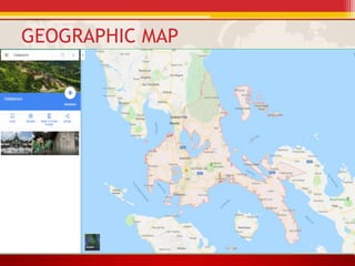
![GEOGRAPHY
CALABARZON is the 12th largest region in the Philippines, with an area of
16,873.31 km2. The region itself is relatively flat, but also consists of coastal areas and
highlands.[14] CALABARZON is bordered by Manila Bay in the west, Metro
Manila, Bulacan, and Aurora in the north, Lamon Bay and Bicol in the east, and the Isla
Verde Passage in the south. Each province in the region is composed of different
environments, ranging from low coastal areas to rugged mountainous ones.
Cavite is characterized by rolling hinterlands punctured by hills, with a
shoreline bordering Manila Bay and a rugged portion bordering Batangas near Mount
Pico de Loro. The Tagaytay is located in Cavite, bordering Alfonso, Silang, Calamba,
and Santa Rosa. Mount Sungay is the highest peak in the province and can be found in
Tagaytay. There are nine islands in Cavite, most notable of which is the island
of Corregidor. Historically a site of great strategic importance, Corregidor is found at the
mouth of Manila Bay and is under the jurisdiction of Cavite City.
Laguna has rugged terrain, with narrow plains near the shores of Laguna de
Bay and mountainous ranges further inland. Laguna de Bay is the largest lake in the
Philippines, and is named after the town of Bay. Laguna is also home to Mount
Makiling, a dormant volcano near Los Banos reputed for its mystical properties. There
are also a lot of hot springs near the Makiling area, especially in San Pablo. Another
famous landmark in Laguna are the Pagsanjan Falls, in Cavinti. The water from the
Pagsanjan Falls comes from the Bumbungan River. Mount Banahaw borders Laguna
and Quezon, and is similarly considered to be a holy mountain like Makiling.](https://image.slidesharecdn.com/floreport-180419092218/85/Region-IV-7-320.jpg)

![POPULATION AND LAND AREA
Calabarzon has a population of 14.4 million people, the largest of all
the regions in the Philippines.[1] The population growth rate between 2000 and
2010 of 3.07% decreased from the growth rate between 1990 and 2000 of
3.91%, a trend which coincided with the rest of the nation. Life expectancy for
men in Calabarzon is 68.9 years and 75.2 years for women. There are an
estimated 356,000 Overseas Filipino Workers originally from Calabarzon.
A vast majority of people living in Calabarzon are Tagalogs. It is
estimated that around 5.8 million Tagalogs live in Region IV-A. Taal, in
particular, is considered the "Heartland of Tagalog Culture" and is currently
the present "center" of Tagalog culture and people. Calabarzon is also home to
a sizable number of people with Chinese and Spanish ancestry on account of
Chinese immigration and Spanish colonialization, respectively. Because of this
large majority of Tagalog natives, the majority of people living in Calabarzon
also speak the Tagalog language. Filipino, being a version of Tagalog, is also
predominant in the region. English is also commonly spoken throughout
Calabarzon and is the language of business and education. In
Cavite, Chavacano, a Creole language is also commonly spoken.
The large majority of the population of Calabarzon is a part of
the Roman Catholic church which accounts for 80% of the national population.
Other Christian denominations present in the region are the Iglesia Ni Cristo,
the Philippine Independent Church and Seventh-day Adventist Church. There
are also Muslims living in Calabarzon although they are in the minority.](https://image.slidesharecdn.com/floreport-180419092218/85/Region-IV-10-320.jpg)

![ECONOMY
Calabarzon is the second largest contributor to the national GDP,
accounting for 17% of the gross domestic product. The region boasts a 2.1% inflation
rate, lower than the national average of 3%. The region has a 9.2% unemployment
rate which is higher than the national average of 7%. Calabarzon, much like the rest
of the country, is caught in the middle of being an industrial and an agricultural
economy.
Due to the region's proximity to Metro Manila, a large amount of
urbanization has taken place over the years. Cavite and Laguna in particular are
sites of manufacturing and high-tech industries, with companies
like Intel and Panasonic setting up plants in the region. Santa Rosa, Laguna, is home
to a host of semi-conductor and automotive companies such as Amkor and Toyota,
while General Trias is home to Cavite's largest economic development zone, the PEC
Industrial Park.
The region still has a large agricultural base. As of 2002, the region had
282,700 farms, covering 588,500 hectares (1,454,000 acres), or 36.3% of the
region's total land area.[25] Cavite alone has almost 70,500 hectares (174,000 acres)
of agricultural land. Laguna is home to the International Rice Research Institute,
which can be found within the University of the Philippines Los Baños, whose main
goal is find sustainable ways to help rice farmers. Batangas, meanwhile, is home to a
large pineapple and coconut industry, which is used to make Barong Tagalogs and
native liqueurs such as lambanog and tuba in Tayabas City. Quezon is the country's
leader in coconut products such as coconut oil and copra. Rizal is known for its
piggeries. Region IV-A's agricultural base, however, is slowly decreasing. Due to
their proximity to large bodies of water, Laguna and Batangas also have sizable
fishing industries. Taal Lake is a large source of fresh water fishes for the country.](https://image.slidesharecdn.com/floreport-180419092218/85/Region-IV-12-320.jpg)


![MIMAROPA
The Southwestern Tagalog Region, officially designated
as MIMAROPA Region, is an administrative region in the Philippines. It
was also formerly designated as Region IV-B until 2016. It is one of two
regions in the country having no land border with another region (the other
being Eastern Visayas). The name is an acronym combination of its
constituent provinces: Mindoro (divided into Occidental
Mindoro and Oriental Mindoro), Marinduque, Romblon and Palawan.
The region was part of the now-defunct Southern Tagalog region until
17 May 2002. On 23 May 2005, Palawan and the highly urbanized
city of Puerto Princesa were moved to the region of Western
Visayas by Executive Order No. 429. However, on 19 August 2005, then-
President Arroyo issued Administrative Order No. 129 to put in
abeyance Executive Order No. 429 pending a review. On 17 July
2016, Republic Act No. 10879 formally established the Southwestern Tagalog
Region to be known as the MIMAROPA Region discontinuing the "Region IV-
B" designation, however no boundary changes were involved.
Calapan is Mimaropa's regional center. However, most regional
government offices such as the Department of Public Works and
Highways[7] and the Department of Budget and Management are in Quezon
City, Metro Manila.](https://image.slidesharecdn.com/floreport-180419092218/85/Region-IV-21-320.jpg)