Download free for 30 days
Sign in
Upload
Language (EN)
Support
Business
Mobile
Social Media
Marketing
Technology
Art & Photos
Career
Design
Education
Presentations & Public Speaking
Government & Nonprofit
Healthcare
Internet
Law
Leadership & Management
Automotive
Engineering
Software
Recruiting & HR
Retail
Sales
Services
Science
Small Business & Entrepreneurship
Food
Environment
Economy & Finance
Data & Analytics
Investor Relations
Sports
Spiritual
News & Politics
Travel
Self Improvement
Real Estate
Entertainment & Humor
Health & Medicine
Devices & Hardware
Lifestyle
Change Language
Language
English
Español
Português
Français
Deutsche
Cancel
Save
EN
Uploaded by
Chengtao Lin
26,345 views
QGIS第三講—地圖展示與匯出
AI-enhanced description
本文件介绍了地图的定义、元素及其在QGIS中的绘制过程。内容包括地图制作基础,如图层概念、向量与影像图层的添加、样式和标记设置,以及地图的输出流程。最后,强调了绝对必要的坐标系统设置和图层管理技巧。
Software
◦
Read more
28
Save
Share
Embed
Embed presentation
Download
Downloaded 249 times
1
/ 54
2
/ 54
3
/ 54
4
/ 54
5
/ 54
6
/ 54
7
/ 54
8
/ 54
9
/ 54
10
/ 54
11
/ 54
12
/ 54
13
/ 54
14
/ 54
15
/ 54
16
/ 54
17
/ 54
18
/ 54
19
/ 54
20
/ 54
21
/ 54
22
/ 54
23
/ 54
24
/ 54
25
/ 54
26
/ 54
27
/ 54
28
/ 54
29
/ 54
30
/ 54
31
/ 54
32
/ 54
33
/ 54
34
/ 54
35
/ 54
36
/ 54
37
/ 54
38
/ 54
Most read
39
/ 54
40
/ 54
41
/ 54
42
/ 54
43
/ 54
44
/ 54
45
/ 54
46
/ 54
47
/ 54
48
/ 54
49
/ 54
50
/ 54
Most read
51
/ 54
52
/ 54
53
/ 54
54
/ 54
Most read
More Related Content
PPT
Gis개론
by
guestf37489
PDF
[공간정보시스템 개론] L09 공간 데이터 모델
by
Kwang Woo NAM
PDF
QGIS 影像處理分析(2) 根據點位來抽取環境資料
by
Chengtao Lin
PDF
QGIS第二講 — 向量處理(1) 地理空間運算工具
by
Chengtao Lin
PDF
QGIS 影像處理分析(1) 影像處理工具簡介
by
Chengtao Lin
PPT
領角鴞巢箱製作ppt
by
sweetcindy1114
PPTX
Densely Connected Convolutional Networks
by
harmonylab
PPTX
大域的探索から局所的探索へデータ拡張 (Data Augmentation)を用いた学習の探索テクニック
by
西岡 賢一郎
Gis개론
by
guestf37489
[공간정보시스템 개론] L09 공간 데이터 모델
by
Kwang Woo NAM
QGIS 影像處理分析(2) 根據點位來抽取環境資料
by
Chengtao Lin
QGIS第二講 — 向量處理(1) 地理空間運算工具
by
Chengtao Lin
QGIS 影像處理分析(1) 影像處理工具簡介
by
Chengtao Lin
領角鴞巢箱製作ppt
by
sweetcindy1114
Densely Connected Convolutional Networks
by
harmonylab
大域的探索から局所的探索へデータ拡張 (Data Augmentation)を用いた学習の探索テクニック
by
西岡 賢一郎
What's hot
PDF
mago3D 한국어 소개 자료
by
SANGHEE SHIN
PDF
動画認識における代表的なモデル・データセット(メタサーベイ)
by
cvpaper. challenge
PPTX
[DL輪読会]Dense Captioning分野のまとめ
by
Deep Learning JP
PPTX
物体検出フレームワークMMDetectionで快適な開発
by
Tatsuya Suzuki
PDF
リクルートにおける画像解析事例紹介
by
Recruit Technologies
PDF
[공간정보시스템 개론] L01 공간정보시스템개요
by
Kwang Woo NAM
PDF
論文紹介 : Vision Transformer with Deformable Attention
by
KazunariHemmi
PDF
20190131 lidar-camera fusion semantic segmentation survey
by
Takuya Minagawa
PDF
[공간정보시스템 개론] L03 지구의형상과좌표체계
by
Kwang Woo NAM
PDF
[공간정보시스템 개론] L02 공간정보와 지리정보
by
Kwang Woo NAM
PPSX
Sentinel 2
by
Openmaps
PDF
動作認識の最前線:手法,タスク,データセット
by
Toru Tamaki
PDF
PyQGIS와 PyQt를 이용한 QGIS 기능 확장
by
MinPa Lee
PDF
生成モデルの Deep Learning
by
Seiya Tokui
PDF
[QGIS] 수치지도를 이용한 DEM 생성과 지형분석
by
MinPa Lee
PPTX
XAI (説明可能なAI) の必要性
by
西岡 賢一郎
PDF
[공간정보시스템 개론] L08 gnss의 개념과 활용
by
Kwang Woo NAM
PDF
ECCV2018 Everybody dance now論文紹介 (CV勉強会@関東)
by
Tenki Lee
PDF
지리정보체계(GIS) - [1] GIS 데이터 유형, 구조 알기
by
Byeong-Hyeok Yu
PDF
[공간정보시스템 개론] L11 공간정보의 구축
by
Kwang Woo NAM
mago3D 한국어 소개 자료
by
SANGHEE SHIN
動画認識における代表的なモデル・データセット(メタサーベイ)
by
cvpaper. challenge
[DL輪読会]Dense Captioning分野のまとめ
by
Deep Learning JP
物体検出フレームワークMMDetectionで快適な開発
by
Tatsuya Suzuki
リクルートにおける画像解析事例紹介
by
Recruit Technologies
[공간정보시스템 개론] L01 공간정보시스템개요
by
Kwang Woo NAM
論文紹介 : Vision Transformer with Deformable Attention
by
KazunariHemmi
20190131 lidar-camera fusion semantic segmentation survey
by
Takuya Minagawa
[공간정보시스템 개론] L03 지구의형상과좌표체계
by
Kwang Woo NAM
[공간정보시스템 개론] L02 공간정보와 지리정보
by
Kwang Woo NAM
Sentinel 2
by
Openmaps
動作認識の最前線:手法,タスク,データセット
by
Toru Tamaki
PyQGIS와 PyQt를 이용한 QGIS 기능 확장
by
MinPa Lee
生成モデルの Deep Learning
by
Seiya Tokui
[QGIS] 수치지도를 이용한 DEM 생성과 지형분석
by
MinPa Lee
XAI (説明可能なAI) の必要性
by
西岡 賢一郎
[공간정보시스템 개론] L08 gnss의 개념과 활용
by
Kwang Woo NAM
ECCV2018 Everybody dance now論文紹介 (CV勉強会@関東)
by
Tenki Lee
지리정보체계(GIS) - [1] GIS 데이터 유형, 구조 알기
by
Byeong-Hyeok Yu
[공간정보시스템 개론] L11 공간정보의 구축
by
Kwang Woo NAM
Viewers also liked
PDF
Jupyter 簡介—互動式的筆記本系統
by
Chengtao Lin
PDF
01 jupyter 第一課
by
Yen-lung Tsai
PDF
Foundations of Machine Learning - StampedeCon AI Summit 2017
by
StampedeCon
PDF
Automated AI The Next Frontier in Analytics - StampedeCon AI Summit 2017
by
StampedeCon
PDF
AI in the Enterprise: Past, Present & Future - StampedeCon AI Summit 2017
by
StampedeCon
PDF
AI for Good Global Summit - 2017 Report
by
ITU
PPTX
Revolutionizing Radiology with Deep Learning: The Road to RSNA 2017
by
NVIDIA
PDF
AWS AI Solutions
by
Amazon Web Services Japan
PPTX
Top 5 Deep Learning and AI Stories - October 6, 2017
by
NVIDIA
Jupyter 簡介—互動式的筆記本系統
by
Chengtao Lin
01 jupyter 第一課
by
Yen-lung Tsai
Foundations of Machine Learning - StampedeCon AI Summit 2017
by
StampedeCon
Automated AI The Next Frontier in Analytics - StampedeCon AI Summit 2017
by
StampedeCon
AI in the Enterprise: Past, Present & Future - StampedeCon AI Summit 2017
by
StampedeCon
AI for Good Global Summit - 2017 Report
by
ITU
Revolutionizing Radiology with Deep Learning: The Road to RSNA 2017
by
NVIDIA
AWS AI Solutions
by
Amazon Web Services Japan
Top 5 Deep Learning and AI Stories - October 6, 2017
by
NVIDIA
Similar to QGIS第三講—地圖展示與匯出
PPT
電腦地理製圖報告140~146
by
威融 何
PPT
How to empower community by using GIS lecture 3
by
wang yaohui
PDF
高中B1網路地圖資源介紹
by
Deborah Wang
PDF
高中B1Gis資料蒐集
by
Deborah Wang
PDF
Mapping distribution by_qgis_20141202
by
Cheng Te Hsu
PDF
話我家鄉
by
awcc
PDF
高中B1Gis與生活
by
Deborah Wang
PPTX
[海洋社區發展與GIS應用]10/28 鄧東波 :自己的地圖自己畫
by
Eve Guo
PDF
高中B1地理資訊查詢與分析
by
Deborah Wang
PDF
高中B1等高線判讀
by
Deborah Wang
PDF
磨課師:向量式資料
by
逢甲大學 Feng Chia University
PDF
OpenStreetMap 介紹 @ 朝陽科技大學
by
Sin-di Lee
PDF
20121221 grass root_mapping_open_data&citizen_science
by
Dongpo Deng
PDF
草根性製圖運動的崛起與公民科學的結合
by
Dongpo Deng
PDF
Open seminar series 3: Mapping, Geovisualization and OpenStreetMap
by
Dongpo Deng
PDF
20150427_NCDR_OSM_Disaster_Mapping
by
Dongpo Deng
PDF
高中B1衛星影像的判讀與使用
by
Deborah Wang
PPT
Ch3地形圖的類型與判讀
by
5045033
PDF
自製線上地圖呈現地理資料: 非營利組織案例介紹
by
Dongpo Deng
PDF
自製線上地圖呈現地理資料:非營利組織案例介紹
by
Net Tuesday Taiwan
電腦地理製圖報告140~146
by
威融 何
How to empower community by using GIS lecture 3
by
wang yaohui
高中B1網路地圖資源介紹
by
Deborah Wang
高中B1Gis資料蒐集
by
Deborah Wang
Mapping distribution by_qgis_20141202
by
Cheng Te Hsu
話我家鄉
by
awcc
高中B1Gis與生活
by
Deborah Wang
[海洋社區發展與GIS應用]10/28 鄧東波 :自己的地圖自己畫
by
Eve Guo
高中B1地理資訊查詢與分析
by
Deborah Wang
高中B1等高線判讀
by
Deborah Wang
磨課師:向量式資料
by
逢甲大學 Feng Chia University
OpenStreetMap 介紹 @ 朝陽科技大學
by
Sin-di Lee
20121221 grass root_mapping_open_data&citizen_science
by
Dongpo Deng
草根性製圖運動的崛起與公民科學的結合
by
Dongpo Deng
Open seminar series 3: Mapping, Geovisualization and OpenStreetMap
by
Dongpo Deng
20150427_NCDR_OSM_Disaster_Mapping
by
Dongpo Deng
高中B1衛星影像的判讀與使用
by
Deborah Wang
Ch3地形圖的類型與判讀
by
5045033
自製線上地圖呈現地理資料: 非營利組織案例介紹
by
Dongpo Deng
自製線上地圖呈現地理資料:非營利組織案例介紹
by
Net Tuesday Taiwan
More from Chengtao Lin
PDF
iNaturalist intro
by
Chengtao Lin
PDF
R aggregate data
by
Chengtao Lin
PDF
PostGIS 初入門應用
by
Chengtao Lin
PDF
Taqm yunlin
by
Chengtao Lin
PDF
Forest ecology — Vegetation classification and analysis
by
Chengtao Lin
PDF
QGIS第一講 數位化向量地圖
by
Chengtao Lin
PDF
使用 zotero 做文獻管理及引用(1)
by
Chengtao Lin
iNaturalist intro
by
Chengtao Lin
R aggregate data
by
Chengtao Lin
PostGIS 初入門應用
by
Chengtao Lin
Taqm yunlin
by
Chengtao Lin
Forest ecology — Vegetation classification and analysis
by
Chengtao Lin
QGIS第一講 數位化向量地圖
by
Chengtao Lin
使用 zotero 做文獻管理及引用(1)
by
Chengtao Lin
QGIS第三講—地圖展示與匯出
1.
林 政道 mutolisp _AT_
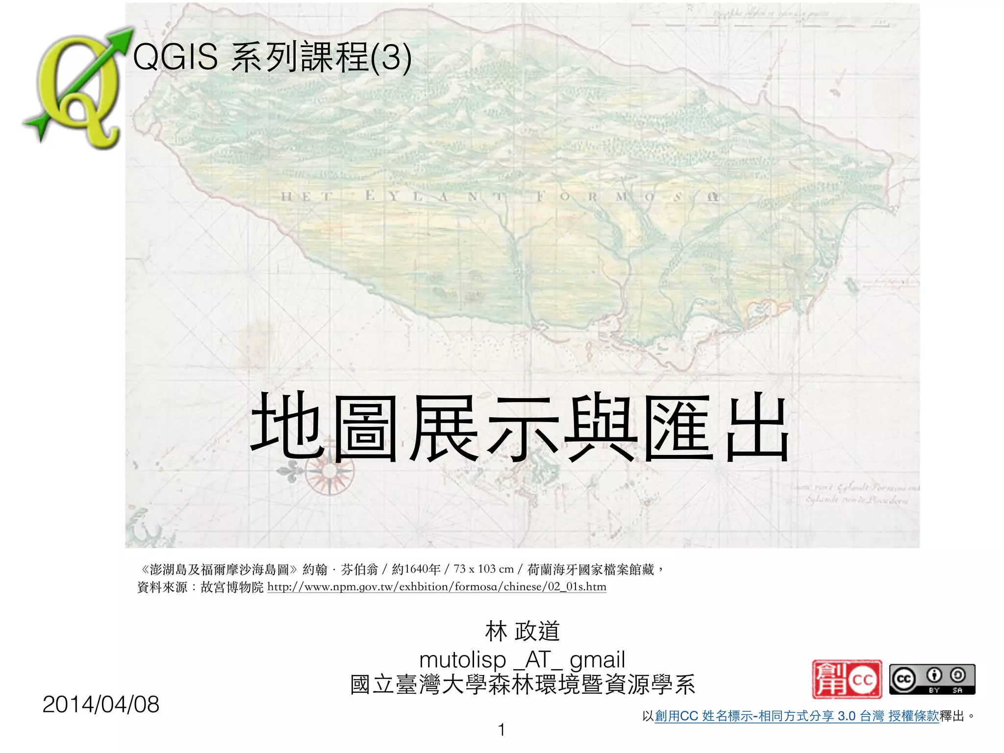
gmail 國⽴立臺灣⼤大學森林環境暨資源學系 以創⽤用CC 姓名標⽰示-相同⽅方式分享 3.0 台灣 授權條款釋出。 QGIS 系列課程(3) 2014/04/08 ! 地圖展⽰示與匯出 《澎湖島及福爾摩沙海島圖》約翰‧芬伯翁/約1640年/73 x 103 cm/荷蘭海牙國家檔案館藏, 資料來源:故宮博物院 http://www.npm.gov.tw/exhbition/formosa/chinese/02_01s.htm 1
2.
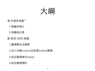
⼤大綱 壹.什麼是地圖? 1.製圖學簡介 2.地圖的元素 貳.使⽤用 QGIS 製圖 1.圖層概念及種類 2.加⼊入向量(vector)及影像(raster)圖層 3.設定圖層樣式(style) 4.設定圖層標記 2
3.
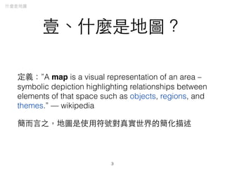
壹、什麼是地圖? 定義:”A map is
a visual representation of an area – symbolic depiction highlighting relationships between elements of that space such as objects, regions, and themes.” — wikipedia 簡⽽而⾔言之,地圖是使⽤用符號對真實世界的簡化描述 3 什麼是地圖
4.
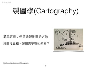
製圖學(Cartography) 簡單定義:學習繪製地圖的⽅方法 沒圖沒真相,製圖需要哪些元素? 4 什麼是地圖 http://en.wikipedia.org/wiki/Cartography
5.
地圖的元素 地圖是⾃自⼰己對世界想像的展現舞台,通常⼀一張地圖擁有 以下元素: (主題) 展⽰示的主題,如地形、地貌等,可以是照⽚片、幾 何線條或抽象的物件來表⽰示 (空間) 關於主題的空間資訊,例如相對位置、經緯度格 線、⽐比例尺等 (地物)
輔助主題的細節標⽰示、可告訴閱讀者的資訊,可 ⽤用⽂文字、抽象符號代表 什麼是地圖 5
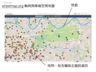
6.
wheelmap.org 輪椅無障礙空間地圖 地貌 地物,包含輔助主題的資訊 什麼是地圖 6
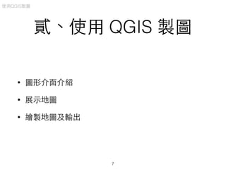
7.
貳、使⽤用 QGIS 製圖 •
圖形介⾯面介紹 • 展⽰示地圖 • 繪製地圖及輸出 使⽤用QGIS製圖 7
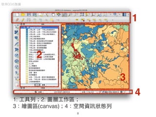
8.
使⽤用QGIS製圖 8 1 2 3 4 1: ⼯工具列;2: 圖層⼯工作區; 3:繪圖區(canvas);4:空間資訊狀態列
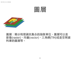
9.
圖層 使⽤用QGIS製圖 圖層:顯⽰示地理資訊集合的抽象單位,圖層可以是 影像(raster)、向量(vector)、三⾓角網(TIN)或是空間資 料庫的圖層等。 9
10.
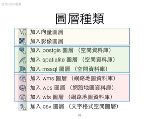
圖層種類 加⼊入向量圖層 加⼊入影像圖層 加⼊入 postgis 圖層
(空間資料庫) 加⼊入 spatialite 圖層 (空間資料庫) 加⼊入 mssql 圖層 (空間資料庫) 加⼊入 wms 圖層 (網路地圖資料庫) 加⼊入 wcs 圖層 (網路地圖資料庫) 加⼊入 wfs 圖層 (網路地圖資料庫) 加⼊入 csv 圖層 (⽂文字格式空間圖層) 10 使⽤用QGIS製圖
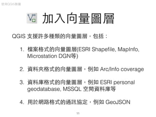
11.
加⼊入向量圖層 QGIS ⽀支援許多種類的向量圖層,包括: 1. 檔案格式的向量圖層(ESRI
Shapefile, MapInfo, Microstation DGN等) 2. 資料夾格式的向量圖層,例如 Arc/Info coverage 3. 資料庫格式的向量圖層,例如 ESRI personal geodatabase, MSSQL 空間資料庫等 4. ⽤用於網路格式的通訊協定,例如 GeoJSON 使⽤用QGIS製圖 11
12.
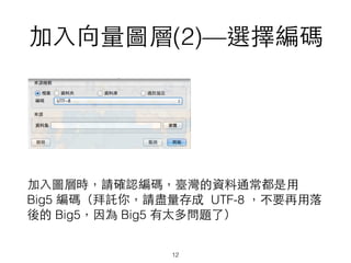
加⼊入向量圖層(2)—選擇編碼 加⼊入圖層時,請確認編碼,臺灣的資料通常都是⽤用 Big5 編碼(拜託你,請盡量存成 UTF-8
,不要再⽤用落 後的 Big5,因為 Big5 有太多問題了) 12
13.
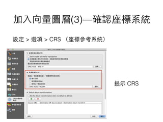
加⼊入向量圖層(3)—確認座標系統 很多⼈人習慣很不好,都沒有設定座標系統,導致圖流通 時,還要玩偵探遊戲,⼤大家來猜猜看這是什麼座標系統, 這跟⽴立法院⿊黑箱的朝野協商沒有兩樣 XD 所以 QGIS
可以設定在開啟沒有設定座標系統的圖時, 提⽰示設定座標系統
14.
加⼊入向量圖層(3)—確認座標系統 設定 > 選項
> CRS (座標參考系統) 提⽰示 CRS
15.
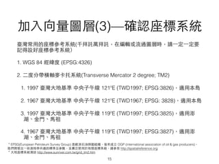
加⼊入向量圖層(3)—確認座標系統 15 臺灣常⽤用的座標參考系統(千拜託萬拜託,在編輯或流通圖層時,請⼀一定⼀一定要 記得設好座標參考系統) 1. WGS 84
經緯度 (EPSG:4326) 2. ⼆二度分帶橫軸⿆麥卡托系統(Transverse Mercator 2 degree; TM2) 1. 1997 臺灣⼤大地基準 中央⼦子午線 121ºE (TWD1997; EPSG:3826),適⽤用本島 2. 1967 臺灣⼤大地基準 中央⼦子午線 121ºE (TWD1967; EPSG: 3828),適⽤用本島 3. 1997 臺灣⼤大地基準 中央⼦子午線 119ºE (TWD1997; EPSG:3825),適⽤用澎 湖、⾦金⾨門、⾺馬祖 4. 1967 臺灣⼤大地基準 中央⼦子午線 119ºE (TWD1997; EPSG:3827),適⽤用澎 湖、⾦金⾨門、⾺馬祖 *EPSG(European Petroleum Survey Group) 是歐洲⽯石油探勘組織,後來成⽴立 OGP (international association of oil & gas producers), 他們開發出⼀一些測地學共通的標準及參數,並廣泛使⽤用於地理座標系統,請參⾒見 http://spatialreference.org *⼤大地座標系統漫談 http://www.sunriver.com.tw/grid_tm2.htm
17.
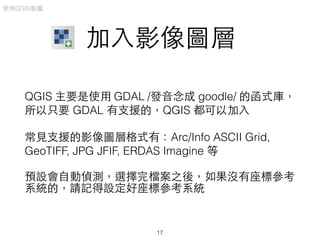
加⼊入影像圖層 QGIS 主要是使⽤用 GDAL
/發⾳音念成 goodle/ 的函式庫, 所以只要 GDAL 有⽀支援的,QGIS 都可以加⼊入 常⾒見⽀支援的影像圖層格式有:Arc/Info ASCII Grid, GeoTIFF, JPG JFIF, ERDAS Imagine 等 預設會⾃自動偵測,選擇完檔案之後,如果沒有座標參考 系統的,請記得設定好座標參考系統 使⽤用QGIS製圖 17
18.
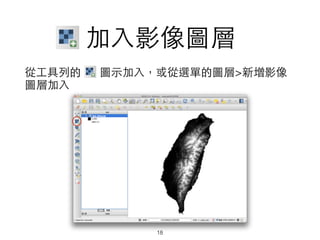
加⼊入影像圖層 從⼯工具列的 圖⽰示加⼊入,或從選單的圖層>新增影像 圖層加⼊入 18
19.
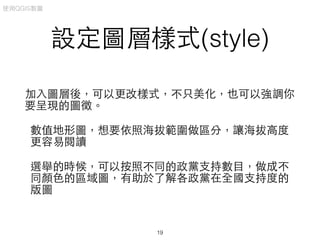
設定圖層樣式(style) 加⼊入圖層後,可以更改樣式,不只美化,也可以強調你 要呈現的圖徵。 數值地形圖,想要依照海拔範圍做區分,讓海拔⾼高度 更容易閱讀 選舉的時候,可以按照不同的政黨⽀支持數⺫⽬目,做成不 同顏⾊色的區域圖,有助於了解各政黨在全國⽀支持度的 版圖 使⽤用QGIS製圖 19
20.
設定圖層樣式(例) 全臺灣的數值地形圖,不同的顏⾊色 代表不同的海拔帶,愈冷的顏⾊色 (藍⾊色)代表愈⾼高海拔,愈暖的 顏⾊色代表愈低海拔 使⽤用QGIS製圖 20
21.
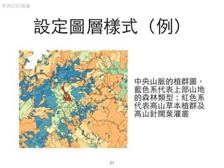
設定圖層樣式(例) 中央⼭山脈的植群圖, 藍⾊色系代表上部⼭山地 的森林類型;紅⾊色系 代表⾼高⼭山草本植群及 ⾼高⼭山針闊葉灌叢 使⽤用QGIS製圖 21
22.
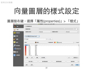
向量圖層的樣式設定 圖層按右鍵,選擇「屬性(properties)」> 「樣式」 使⽤用QGIS製圖 22
23.
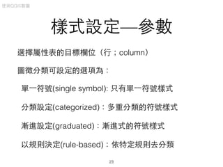
樣式設定—參數 選擇屬性表的⺫⽬目標欄位(⾏行;column) 圖徵分類可設定的選項為: 單⼀一符號(single symbol): 只有單⼀一符號樣式 分類設定(categorized):多重分類的符號樣式 漸進設定(graduated):漸進式的符號樣式 以規則決定(rule-based):依特定規則去分類 使⽤用QGIS製圖 23
24.
樣式設定—圖徵分類 單⼀一符號:適合⽤用於簡單的圖徵,且屬性 表分類只有單⼀一項的圖層,例如邊界圖或 是⾏行政區域圖 分類設定:適合⽤用於離散(categorical)的資 料,例如⼟土壤性質圖、植群圖等 漸進設定:適合⽤用於連續性的資料,例如 溫度、⾬雨量、海拔等 使⽤用QGIS製圖 24
25.
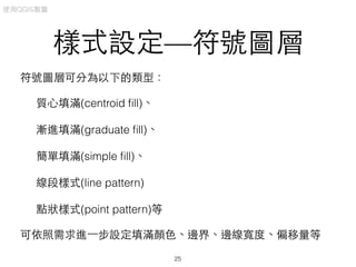
樣式設定—符號圖層 符號圖層可分為以下的類型: 質⼼心填滿(centroid fill)、 漸進填滿(graduate fill)、 簡單填滿(simple
fill)、 線段樣式(line pattern) 點狀樣式(point pattern)等 可依照需求進⼀一步設定填滿顏⾊色、邊界、邊線寬度、偏移量等 使⽤用QGIS製圖 25
26.
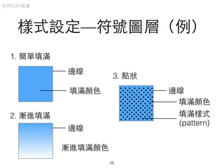
樣式設定—符號圖層(例) 1. 簡單填滿 邊線 填滿顏⾊色 邊線 漸進填滿顏⾊色 2. 漸進填滿 邊線 填滿顏⾊色 填滿樣式 (pattern) 3.
點狀 使⽤用QGIS製圖 26
27.
樣式設定—填滿樣式及邊線樣式 可依照需求選擇不同的填滿 顏⾊色、樣式以及邊線的設定 (需要耐⼼心去設計,盡量讓 圖簡單、清楚,容易閱讀為 原則) 27 使⽤用QGIS製圖
28.
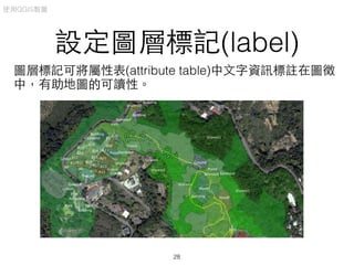
設定圖層標記(label) 圖層標記可將屬性表(attribute table)中⽂文字資訊標註在圖徵 中,有助地圖的可讀性。 使⽤用QGIS製圖 28
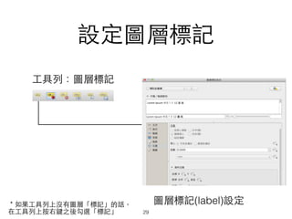
29.
設定圖層標記 圖層標記(label)設定 ⼯工具列:圖層標記 *如果⼯工具列上沒有圖層「標記」的話, 在⼯工具列上按右鍵之後勾選「標記」 29
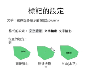
30.
標記的設定 ⽂文字:選擇想要顯⽰示的欄位(column) ⽂文字背景 ⽂文字陰影⽂文字輪廓格式的設定: 位置的設定: 例 圍繞質⼼心 貼近邊線
⾃自由(⽔水平) 30
31.
設定圖層樣式—實例操作 同時加⼊入向量及影像圖層,並⽤用不同顏⾊色來區別圖徵 1. 加⼊入圖層並整理分類成不同群組 2. 設定圖層樣式 3.
設定圖層標記 使⽤用QGIS製圖 31
32.
使⽤用QGIS製圖 32
33.
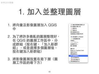
1. 加⼊入並整理圖層 1. 將向量及影像圖層加⼊入
QGIS 中 2. 為了將許多雜亂的圖層整理好, 在 QGIS 的圖層⼯工作區中,分 成群組(按右鍵,「加⼊入新群 組」,或是選擇多個圖層後, 按右鍵加⼊入新群組) 3. 將影像圖層放置在最下層(圖 層⼯工作區的最下⽅方) 使⽤用QGIS製圖 33
34.
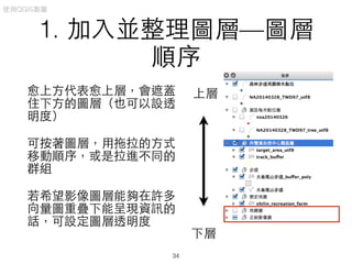
1. 加⼊入並整理圖層—圖層 順序 愈上⽅方代表愈上層,會遮蓋 住下⽅方的圖層(也可以設透 明度) 可按著圖層,⽤用拖拉的⽅方式 移動順序,或是拉進不同的 群組 若希望影像圖層能夠在許多 向量圖重疊下能呈現資訊的 話,可設定圖層透明度 下層 上層 使⽤用QGIS製圖 34
35.
2. 設定圖層樣式 要設定之前,請先想⼀一下: 依照資料類型去判斷什麼樣的樣式⽐比較適合?是單⼀一 符號、分類設定還是漸進式? 使⽤用QGIS製圖 35
36.
3. 設定圖標 複雜的圖徵需要有圖標和圖例來幫助閱讀 設定之前請考慮⽂文字⼤大⼩小、樣式和對⽐比(例:背景是深 ⾊色,⽂文字請⽤用淺⾊色)等 使⽤用QGIS製圖 36
37.
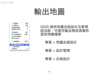
輸出地圖 QGIS 提供地圖出版設計及管理 的功能,可製作輸出精美⾼高解析 度的地圖檔案 專案 >
地圖出版設計 專案 > 設計管理 專案 > 出版設計 使⽤用QGIS製圖 37
38.
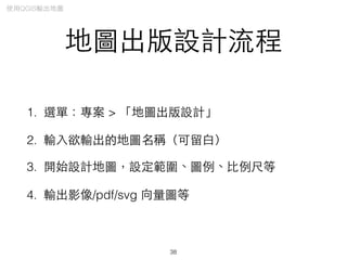
地圖出版設計流程 1. 選單:專案 >
「地圖出版設計」 2. 輸⼊入欲輸出的地圖名稱(可留⽩白) 3. 開始設計地圖,設定範圍、圖例、⽐比例尺等 4. 輸出影像/pdf/svg 向量圖等 38 使⽤用QGIS輸出地圖
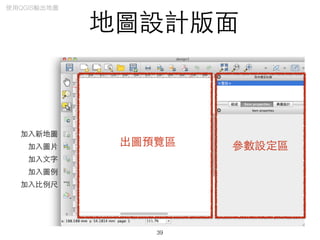
39.
地圖設計版⾯面 出圖預覽區 參數設定區 加⼊入新地圖 加⼊入圖⽚片 加⼊入⽂文字 加⼊入圖例 加⼊入⽐比例尺 39 使⽤用QGIS輸出地圖
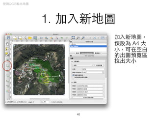
40.
1. 加⼊入新地圖 加⼊入新地圖, 預設為 A4
⼤大 ⼩小,可在空⽩白 的出圖預覽區 拉出⼤大⼩小 40 使⽤用QGIS輸出地圖
41.
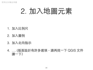
2. 加⼊入地圖元素 1. 加⼊入⽐比例尺 2.
加⼊入圖例 3. 加⼊入北向指⽰示 4. …. (版⾯面設計有許多選項,請再找⼀一下 QGIS ⽂文件 讀⼀一下) 41 使⽤用QGIS輸出地圖
42.
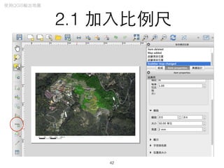
2.1 加⼊入⽐比例尺 42 使⽤用QGIS輸出地圖
43.
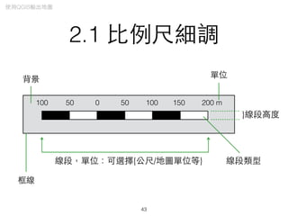
2.1 ⽐比例尺細調 0 50
100 150 200 m50100 }線段⾼高度 單位 線段,單位:可選擇{公尺/地圖單位等} 線段類型 背景 框線 43 使⽤用QGIS輸出地圖
44.
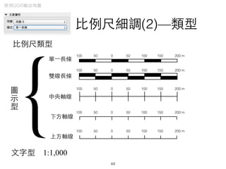
⽐比例尺細調(2)—類型 ⽐比例尺類型 0 50 100
150 200 m50100 0 50 100 150 200 m50100 單⼀一⻑⾧長條 雙線⻑⾧長條 0 50 100 150 200 m50100 0 50 100 150 200 m50100 0 50 100 150 200 m50100 中央軸線 下⽅方軸線 上⽅方軸線 圖 ⽰示 型 {⽂文字型 1:1,000 44 使⽤用QGIS輸出地圖
45.
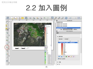
2.2 加⼊入圖例 45 使⽤用QGIS輸出地圖
46.
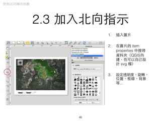
2.3 加⼊入北向指⽰示 1. 插⼊入圖⽚片 2.
在圖⽚片的 item properties 中搜尋 資料夾(QGIS內 建,也可以⾃自⼰己設 計 svg 檔) 3. 設定透明度、旋轉、 位置、框線、背景 等... 46 使⽤用QGIS輸出地圖
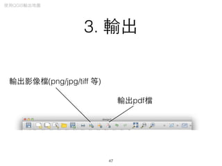
47.
3. 輸出 輸出影像檔(png/jpg/tiff 等) 輸出pdf檔 47 使⽤用QGIS輸出地圖
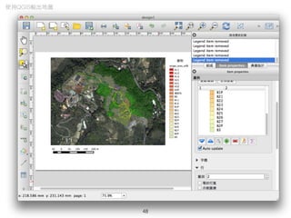
48.
48 使⽤用QGIS輸出地圖
49.
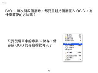
49 FAQ FAQ 1. 每次開啟圖層時,都要重新把圖層匯⼊入
QGIS ,有 什麼簡便的⽅方法嗎? 只要從選單中的專案 > 儲存,儲 存成 QGIS 的專案檔就可以了!
50.
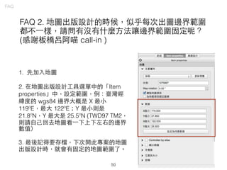
50 FAQ FAQ 2. 地圖出版設計的時候,似乎每次出圖邊界範圍 都不⼀一樣,請問有沒有什麼⽅方法讓邊界範圍固定呢? (感謝板橋呂阿喵
call-in ) 1. 先加⼊入地圖 2. 在地圖出版設計⼯工具選單中的「Item properties」中,設定範圍,例:臺灣經 緯度的 wgs84 邊界⼤大概是 X 最⼩小 119ºE,最⼤大 122ºE;Y 最⼩小則是 21.8ºN,Y 最⼤大是 25.5ºN (TWD97 TM2, 則請⾃自⼰己回去地圖看⼀一下上下左右的邊界 數值) 3. 最後記得要存檔,下次開此專案的地圖 出版設計時,就會有固定的地圖範圍了。
51.
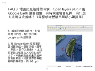
51 FAQ FAQ 3. 地圖出版設計的時候,Open
layers plugin 的 Google Earth 讀圖很慢,有時候還會圖亂掉,有什麼 ⽅方法可以改善嗎?(同樣感謝板橋呂阿喵⼩小姐提問) 1. 增加你的網路速度,打電 話問 ISP 說,為什麼我讀 google earth 這麼慢 2. 把 Google Earth 你想要的 區域圖存成⼀一個影像檔(選單 :專案 > 另存為影像),之後 只要把這張圖加⼊入 QGIS 就可 以了,不過缺點是輸出的解析 度會⽐比較差(相當於你螢幕觀 看時的解析度,約 96 dpi)
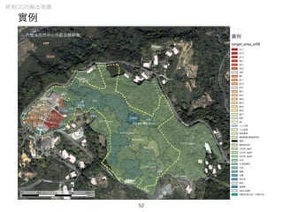
52.
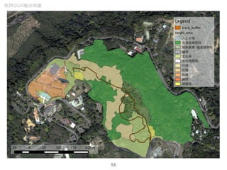
實例 52 使⽤用QGIS輸出地圖
53.
53 使⽤用QGIS輸出地圖
54.
如果你覺得這份投影⽚片對你很有幫助,請考慮: ! 1. 直接贊助我,⼀一元不嫌少、⼀一杯咖啡也很好 2. 捐款給
QGIS* 或是⾃自由軟體基⾦金會(Free Software Foundation) 3. 贊助獨⽴立媒體及NGO,例如環境資訊協會、新頭 殼、公投盟等 *https://www.qgis.org/en/site/getinvolved/donations.html
Download


![[공간정보시스템 개론] L09 공간 데이터 모델](https://cdn.slidesharecdn.com/ss_thumbnails/l09-170314114718-thumbnail.jpg?width=640&height=640&fit=bounds)


![[DL輪読会]Dense Captioning分野のまとめ](https://cdn.slidesharecdn.com/ss_thumbnails/dlseminar-201202012355-thumbnail.jpg?width=640&height=640&fit=bounds)


![[공간정보시스템 개론] L01 공간정보시스템개요](https://cdn.slidesharecdn.com/ss_thumbnails/l01-170314114926-thumbnail.jpg?width=640&height=640&fit=bounds)


![[공간정보시스템 개론] L03 지구의형상과좌표체계](https://cdn.slidesharecdn.com/ss_thumbnails/l03-170314115023-thumbnail.jpg?width=640&height=640&fit=bounds)
![[공간정보시스템 개론] L02 공간정보와 지리정보](https://cdn.slidesharecdn.com/ss_thumbnails/l02-170314114945-thumbnail.jpg?width=640&height=640&fit=bounds)


![[QGIS] 수치지도를 이용한 DEM 생성과 지형분석](https://cdn.slidesharecdn.com/ss_thumbnails/osgeo-211122235838-thumbnail.jpg?width=640&height=640&fit=bounds)

![[공간정보시스템 개론] L08 gnss의 개념과 활용](https://cdn.slidesharecdn.com/ss_thumbnails/l08gnss-170314114625-thumbnail.jpg?width=640&height=640&fit=bounds)

![지리정보체계(GIS) - [1] GIS 데이터 유형, 구조 알기](https://cdn.slidesharecdn.com/ss_thumbnails/sugis2018c01-180902151613-thumbnail.jpg?width=640&height=640&fit=bounds)
![[공간정보시스템 개론] L11 공간정보의 구축](https://cdn.slidesharecdn.com/ss_thumbnails/l11-170314114751-thumbnail.jpg?width=640&height=640&fit=bounds)


![[海洋社區發展與GIS應用]10/28 鄧東波 :自己的地圖自己畫](https://cdn.slidesharecdn.com/ss_thumbnails/20141028gisppt-141110013528-conversion-gate01-thumbnail.jpg?width=640&height=640&fit=bounds)


