Download to read offline
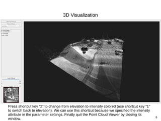
![5
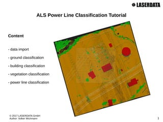
3D Visualization
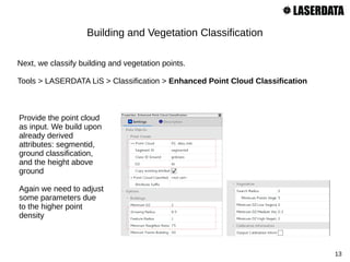
Let's have a quick look at the data set in 3D. We can use the Point Cloud Viewer for this
purpose:
Tools > LASERDATA LiS > Visualization > Point Cloud Viewer [interactive]
Provide the point
cloud as input.
Also provide the
“intensity” attribute
with the Intensity
parameter.](https://image.slidesharecdn.com/lisalspowerlineclassification-170704134114/85/Point-cloud-classifiation-including-Powerlines-with-Laserdata-LIS-Software-5-320.jpg)

![8
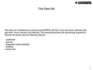
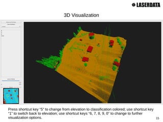
3D Visualization
Let's have a look at the ground classification result in 3D:
Tools > LASERDATA LiS > Visualization > Point Cloud Viewer [interactive]
The tool remembers the
last setting, so we only
have to provide the new
“grdclass” attribute with the
Classification parameter.](https://image.slidesharecdn.com/lisalspowerlineclassification-170704134114/85/Point-cloud-classifiation-including-Powerlines-with-Laserdata-LIS-Software-8-320.jpg)
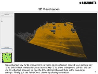
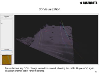
![11
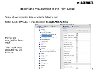
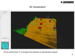
3D Visualization
Let's have a look at the segmentation result in 3D:
Tools > LASERDATA LiS > Visualization > Point Cloud Viewer [interactive]
Provide the new “segmentid”
attribute with the Random
parameter. This allows us to
colorize the segments by
random.](https://image.slidesharecdn.com/lisalspowerlineclassification-170704134114/85/Point-cloud-classifiation-including-Powerlines-with-Laserdata-LIS-Software-11-320.jpg)
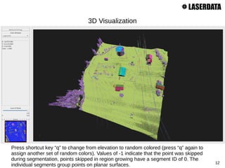
![14
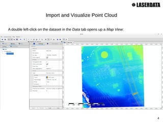
3D Visualization
Let's have a look at the building and vegetation classification result in 3D:
Tools > LASERDATA LiS > Visualization > Point Cloud Viewer [interactive]
Change the attribute provided
with the Classification
parameter from “grdclass” to
“classid”.](https://image.slidesharecdn.com/lisalspowerlineclassification-170704134114/85/Point-cloud-classifiation-including-Powerlines-with-Laserdata-LIS-Software-14-320.jpg)

![17
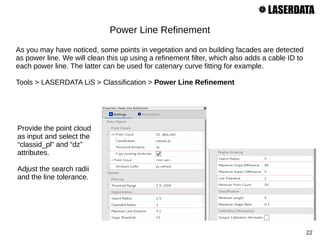
3D Visualization
Let's have a look at the refined building classification in 3D:
Tools > LASERDATA LiS > Visualization > Point Cloud Viewer [interactive]
Change the attribute provided
with the Classification
parameter from “classid” to
“majority_classid”.](https://image.slidesharecdn.com/lisalspowerlineclassification-170704134114/85/Point-cloud-classifiation-including-Powerlines-with-Laserdata-LIS-Software-17-320.jpg)


![20
3D Visualization
Let's have a look at the preliminary power line classification result in 3D:
Tools > LASERDATA LiS > Visualization > Point Cloud Viewer [interactive]
Change the attribute provided
with the Classification
parameter from
“majority_classid” to
“classid_pl”.](https://image.slidesharecdn.com/lisalspowerlineclassification-170704134114/85/Point-cloud-classifiation-including-Powerlines-with-Laserdata-LIS-Software-20-320.jpg)
![23
3D Visualization
Let's have a look at the refined power line classification in 3D:
Tools > LASERDATA LiS > Visualization > Point Cloud Viewer [interactive]
Change the Classification parameter to
“classid_pl_refined” and the Random
parameter to “cableid_pl_refined”.](https://image.slidesharecdn.com/lisalspowerlineclassification-170704134114/85/Point-cloud-classifiation-including-Powerlines-with-Laserdata-LIS-Software-23-320.jpg)
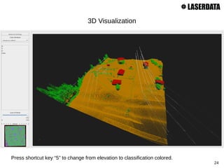
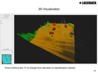
![27
3D Visualization
Let's have a look at the final classification result in 3D:
Tools > LASERDATA LiS > Visualization > Point Cloud Viewer [interactive]
Change the Classification parameter to
“classid_pl_refined_final”](https://image.slidesharecdn.com/lisalspowerlineclassification-170704134114/85/Point-cloud-classifiation-including-Powerlines-with-Laserdata-LIS-Software-27-320.jpg)

This document is a tutorial on classifying power line data using a LAS file format, detailing various classification processes including ground, building, vegetation, and power line classifications. It provides step-by-step instructions for importing and visualizing point clouds, performing segmentation, and refining classifications using specific tools and parameters. The final output includes a 3D visualization of the classified data, ensuring effective classification and cleaning of the point cloud dataset.


