SlideShare a Scribd company logo
1
Course Title: Engineering Geology
Course Code: EG453CE
UNIT 7
Physical Geology
Dr. Suman Manandhar, Dr. Eng. & PostDoc
(Kyushu University)
Visiting Faculty,
School of Engineering, Department of Civil & Geomatic Engineering, Kathmandu University, NEPAL
Visiting Associate Professor
Institute of Lowland and Marine Research (ILMR), Saga University, JAPAN
Former Secretary General cum Treasurer
International Association of Lowland Technology (IALT), JAPAN
Chief Guest Editor & Associate Editor
Lowland Technology International Journal (LTI), JAPAN
Unit 7: Physical Geology
2
Phases
Geological Agents and Geological
Cycle
Geomorphological Process:
Weathering and Erosion
Geological Agents: Landform
Produced By Glacier, River,
Groundwater, Wind and Sea-water
Suman Manandhar, Dr. Eng. (Geotechnical Engineering)
2
Geological Agents
Suman Manandhar, Dr. Eng. (Geotechnical Engineering) 3
Suman Manandhar, Dr. Eng. (Geotechnical
Engineering)
4
3
Suman Manandhar, Dr. Eng. (Geotechnical
Engineering)
5
Suman Manandhar, Dr. Eng. (Geotechnical
Engineering)
6
4
The Geological Cycle
• Internal geologic processes
– Generally build up the earth’s surface
• External geologic processes
– Generally wear down the earth’s surface
– Driven directly or indirectly by sun and gravity
• Weathering
– Physical, Chemical, and Biological
• Erosion
– Wind
– Flowing water
– Human activities
– Glaciers
Suman Manandhar, Dr. Eng. (Geotechnical
Engineering)
7
Source: Google Suman Manandhar, Dr. Eng. (Geotechnical
Engineering)
8
5
9
Suman Manandhar, Dr. Eng. (Geotechnical Engineering)
The upper part of the crust are in close interaction with the process
of atmosphere, hydrosphere and biosphere. So mostly rocks are not
stable and resistant.
Source: Google
6
Weathering
 Breakdown of earth materials due to
various factors.
 Disintegration or alteration of rock
in its natural or original position at or
near the Earth’s surface.
 Weathering refers to the combination
of processes that break up and
corrode solid rock, eventually
transforming it into sediment.
Denudation
• Weathering + Erosion +Transportation
• Exposed or uncovered the rocks.
• It is the process of breaking the earth’s surface by the help of external force,
converted into loose soil and transport to other places.
Source: Google
11
Suman Manandhar, Dr. Eng. (Geotechnical Engineering)
Characteristics of weathering:
• disintegration of rocks
• chemical change in rocks
• change in the surface of land
• formation of soil
due to change in temperature and weather.
Source: Google
12
Suman Manandhar, Dr. Eng. (Geotechnical Engineering)
7
13
Weathering processes
Micas  Vermiculite  Smectite  Kaolinite  Al,Fe-Oxides
Young, weakly weathered soils
= fine-grained mica, chlorite, vermiculite
(Entisol, Inceptisol)
Intermediate weathering
= vermiculite,smectite, kaolinite
(Mollisol,Alfisol, Ultisol)
Strong weathering
= kaolinite, hydrous oxides
(Ultisol--> Oxisol)
Suman Manandhar, Dr. Eng. (Geotechnical Engineering)
14
Suman Manandhar, Dr. Eng. (Geotechnical Engineering)
8
 Physical or MechanicalWeathering
 ChemicalWeathering
 BiologicalWeathering
 PhysicalWeathering
 Processes that disintegration and decay of rocks via weather elements
without altering its composition.
 Takes place when rock is split or broken into smaller pieces of the same
material without changing its composition
• Abrasion or grinding
• Freeze and thaw
• Exfoliation (Sheet)
• Frost action
• Effect of Vegetation
FrostWeathering
16
Suman Manandhar, Dr. Eng. (Geotechnical Engineering)
Source: Google
9
Freeze andThawWeathering
17
Suman Manandhar, Dr. Eng. (Geotechnical Engineering)
Source: Google
Exfoliation
• Weathering due to pressure
release.
• Outer layer of the rock
expand more than inner
layer and thin slabs of rock
form and detached.
Bed rock within the earth’s surface in under high pressure and temperature.
When uplift and erosion brings bed rock to the surface, its temperature drop slowly
while pressure drop immediately.The sudden drop cause the rock to rapidly
expand and crack, this is due to pressure expansion and is called sheeting or
exfoliation, the surface spalls off in layers.
Source: Google
10
Effect of Vegetation
Source: Google
 ChemicalWeathering
 Processes that change the chemical composition of rocks
and minerals. It decomposes rocks through a chemical change in
its minerals.
• Dissolution
• Carbonation
• Oxidation
• Hydrolysis
• Hydration
11
• Water reacts with rock and helps
in dissolving of minerals.
• Water leads in dissolve minerals in
the rock forming holes or voids.
• Weathering by water.
For instance, dissolving of sugar or
salt (halite).
21
Dissolution
Suman Manandhar, Dr. Eng. (Geotechnical
Engineering)
• Acidic water reacts with rock and
helps in dissolving of minerals.
• Acid react with water.
• Water containing acid from dissolved
carbon dioxide leads to dissolve
minerals in the rock leaving cavities.
(limestone caves).
22
Carbonation
Suman Manandhar, Dr. Eng. (Geotechnical Engineering)
Source: Google
12
• Iron combines with oxygen in
the presence of water in a
processes called oxidation.
• The product of oxidation is rust.
(rusting)
23
Oxidation
Suman Manandhar, Dr. Eng. (Geotechnical Engineering)
Source: Google
• Water reacts with rock for a long time and the minerals dissolve forming clay
which is also called as leaching.
• Decomposition of rocks generally contains silicate minerals.
• Silicate minerals generally formed clay due to hydrolysis.
• Igneous rocks have much silica which readily combines with water.
24
Hydrolysis
Suman Manandhar, Dr. Eng. (Geotechnical Engineering)
Source: Google
13
25
Difference between Hydrolysis & Dissolution
Suman Manandhar, Dr. Eng. (Geotechnical Engineering)
• In this weathering the hydroxyl molecules are inserted into the
molecular structures of minerals and decomposed.
26
Hydration
Suman Manandhar, Dr. Eng. (Geotechnical Engineering)
Source: Google
14
 Biological Weathering
Biological weathering takes place when rocks are broken down by
living organisms.Trees and other plants can grow within the cracks
in a rock formation. As the roots grow bigger they push open
cracks in the rocks making them wider and deeper.
Tiny organisms like bacteria, algae and moss can grow on rocks
and produce chemicals which can break down the surface layer of
the rock. Burrowing animals such as rabbits can accelerate the
formation of cracks.
• Action of plants and animals
• Lichens (algae and fungi living as single unit) and mosses
grow on rocks.
• They wedge their tiny roots into spores and crevices.
• When the roots grow, the rock splits.
• Burrowing animals can increase weathering.
Source: Google
28
Suman Manandhar, Dr. Eng. (Geotechnical Engineering)
15
• A part of rainfall always snips into the soil on the covered rocks
and looses the rock particle by dissolving it.
• Frost action also takes place in the pore spaces of rocks and
causes disintegration and splitting of rocks into fragments.
• Chemical reactions are also taking place in rocks internally and
causing rock loosening.
• Slow geological process of construction and destruction.
Factors ofWeathering
29
Suman Manandhar, Dr. Eng. (Geotechnical Engineering)
1. Rock composition:
There are certain elements which are included in rock composition. Some rocks will
weather quickly and some slowly e.g. acidic rocks weather more quickly than basic
ones.
2. Climate:
It includes the meteorological elements effect on rocks such as moisture,
temperature, and wind and air pressure. Climate determines whether physical or
chemical weathering will be more active and speedy.
3.Topography
Topography directly effects weathering by exposing rocks to the temperature or sun
and wind. The elevated areas will be affected more and low level areas will be
affected less.
4.Vegetation (Floral effect)
Surface covered by the vegetation are protected from weathering but bare surfaces
are weathered to great extent. Thin root plants protects weathering. Thick root
plants accelerates weathering.
30
Suman Manandhar, Dr. Eng. (Geotechnical Engineering)
16
• Weathering gradually weakens rocks, and eventually produces new
geological materials (rock fragments, sands, silts and clays) that are more
stable in the new environment.
• Weathering generally produces finer and less dense rock materials,
and weaker, more porous and permeable rock masses.
• In the tropics and subtropics, intense weathering in the hot and
humid conditions produces thick weathered profiles, which may be
up to 100 meters, or more, thick.
Weathering Products
31
Suman Manandhar, Dr. Eng. (Geotechnical Engineering)
ꝿ Destabilization of natural slope.
ꝿ Removal of surface materials.
ꝿ Formation of soil or sediment.
ꝿ Chemical modification of soil.
Impact of Weathering
32
Suman Manandhar, Dr. Eng. (Geotechnical Engineering)
Agents of Weathering
 Water
 Wind
 Glacial
 Waves (Sea waves)
 Under ground water
17
Difference between
Weathering and Erosion
Weathering - processes at or near Earth’s surface
that cause rocks and minerals to break down
Erosion - process of removing Earth materials from
their original sites through weathering and transport
33
Suman Manandhar, Dr. Eng. (Geotechnical Engineering)
Weathering Profile of Granitic Rock
34
Suman Manandhar, Dr. Eng. (Geotechnical Engineering)
Source: Google
18
Engineering Classification
of Weathering of Rocks
35
Suman Manandhar, Dr. Eng. (Geotechnical
Engineering)
Weathering classification suggested by
ISRM Working Party, 1981.
36
Suman Manandhar, Dr. Eng. (Geotechnical
Engineering)
19
Different stages of
weathering of rocks and
formation of soil.
Suman Manandhar, Dr. Eng. (Geotechnical Engineering) 37
Source: Google
The 5 Factors of Formation
Soil is formed by…
• Parent Material: the original “Mom & Pop” soil transported
from elsewhere, usually by wind or water, at different speeds.
• Climate: the amount, intensity, timing, and kind of
precipitation that breaks down parts of ecosystem (i.e. rocks,
trees) into soil.
• Topography: Slope and Aspect affect the angle of the land and
position toward/away from the sun that soil will be exposed
to.
• Biological: Plants, animals, microscopic organisms, and
humans interact with soil in different ways.
• Time: the amount of time it takes for the four factors
(above) to interact with each other.
38
Suman Manandhar, Dr. Eng. (Geotechnical Engineering)
20
Soil Profile
• A Soil Profile is a vertical cross-section of layers of soil found in a
given area. Below are two examples of soil profiles.
39
Suman Manandhar, Dr. Eng. (Geotechnical Engineering)
Source: Google
Soil Horizon
• Soil horizons are the layers in a soil profile used to classify soil
types.
• Horizons based on color, texture, roots, structure, rock
fragments, and any unique characteristic worth noting.
• Master Soil Horizons are depicted by a capital letter in the order
(from top down): O, A, E, B, C, and R
40
Suman Manandhar, Dr. Eng. (Geotechnical
Engineering)
21
O-Horizon
The “Organic Matter”
Horizon
• Surface-layer, at depths of 0-2 feet
• Dark in color, soft in texture
• Humus - rich organic material of
plant and animal origin in a stage of
decomposition
• Leaf litter – leaves, needles, twigs,
moss, lichens that are not
decomposing
• Several O-layers can occur in some
soils, consisting only of O-horizons
41
Suman Manandhar, Dr. Eng. (Geotechnical Engineering)
Source: Google
A-Horizon
“Topsoil” or “Biomantle”
Horizon
• Topmost layer of mineral soil, at
depths of 2-10 feet
• Some humus present, darker in
color than layers below
• Biomantle - most biological
productive layer; earthworms,
fungi, and bacteria live this layer
• Smallest and finest soil particles
42
Suman Manandhar, Dr. Eng. (Geotechnical
Engineering)
22
E-Horizon
The “Leaching Layer”
Horizon
• Small layer between A & B
horizons
• At depths of 10-15 feet
• Light in color, mainly sand & silt
• Poor mineral and clay content
due to leaching – the loss of
water-retaining plant nutrients
to the water table
• Soil particles larger than in A
horizon but smaller than in B
horizon
43
Suman Manandhar, Dr. Eng. (Geotechnical Engineering)
Source: Google
B-Horizon
The “Subsoil” Horizon
• At depths of 10-30 feet
• Rich in clay and minerals like
Fe & Al
• Some organic material may
reach here through leaching
• Plant roots can extend into
this layer
• Red/brown in color due to
oxides of Fe & clay
44
Suman Manandhar, Dr. Eng. (Geotechnical Engineering)
Source: Google
23
C-Horizon
The “Regolith” Horizon
• At depths of 30-48 feet
• Made up of large rocks or
lumps of partially broken
bedrock
• Least affected by
weathering and have
changed the least since
their origin
• Devoid of organic matter
due to it being so far down
in the soil profile
45
Suman Manandhar, Dr. Eng. (Geotechnical
Engineering)
R-Horizon
The “Bedrock”
Horizon
• At depths of 48+ feet
• Deepest soil horizon in
the soil profile
• No rocks or boulders,
only a continuous mass of
bedrock
• Colors are those of the
original rock of the area
46
Suman Manandhar, Dr. Eng. (Geotechnical Engineering)
Source: Google
24
• Fast moving water has a lot of energy and can carry
larger pieces of rocks and sediments.
• Slow moving water has less energy and can only carry
tiny particles of sediment.
• When water loses energy, the sediments settle out.
• Water has the ability to move materials over long
distances.
Erosion by water, is carried out mainly by 2 factors:
• Rainwater (Rainfall)
• Running water (River)
Erosion by Water
47
Suman Manandhar, Dr. Eng. (Geotechnical Engineering)
48
Suman Manandhar, Dr. Eng. (Geotechnical Engineering)
Source: Google
25
Process of erosion due to rainfall
• Splash erosion
– Initial or the first stage of erosion.
– It mainly occurs when rain drops hit
the surface and uppermost layer wash
away.
– Transportation of loose material
comparatively very less.
• Sheet erosion
– Sheet erosion is transportation of
loose soil particles by overland flow.
– Removal of uniform/thin layer of soil
from the soil surface.
– It occurs in shallow depth.
49
Suman Manandhar, Dr. Eng. (Geotechnical Engineering) Source: Google
50
Suman Manandhar, Dr. Eng. (Geotechnical Engineering)
Source: Google
26
Process of erosion due to rainfall
• Rill erosion
– Runoff water form small channels and that
channels wash away soil with them.
– Rills are shallow drainage lines less than 30
cm deep.
• Gully erosion
– Gullies are channels deeper than 30 cm.
– When rills become more deep and wide,
gully formed.
– Erosion that occurs when rills meets together,
widen and deepen.
– Gully erosion can be defined as detachment
and removal of soil in large mass comparative
to others.
51
Suman Manandhar, Dr. Eng. (Geotechnical Engineering)
Source: Google
Development or Formation of Gullies
The gully development is recognized in four stages:
• Formation Stage: Scouring of top soil in the direction of
general slope occurs as the runoff water concentrates. It
normally proceeds slowly where the top soil is fairly resistant
to erosion.
• Development Stage: Causes upstream movement of the
gully head and enlargement of the gully in width and depth. The
parent materials are removed rapidly as water flows.
• Healing Stage:Vegetation starts growing in the gully.
• Stabilization Stage: Gully reaches a stable gradient, gully
walls attain a stable slope and sufficient vegetation cover
develops over the gully surface to anchor the soil and permit
development of new topsoil.
52
Suman Manandhar, Dr. Eng. (Geotechnical Engineering)
27
Classification of Gullies
1. Based on size
53
Suman Manandhar, Dr. Eng. (Geotechnical Engineering)
2. Based on Shape
U-Shaped: These are formed where both the topsoil and subsoil
have the same resistance against erosion. Because the subsoil is
eroded as easily as the topsoil, nearly vertical walls are developed on
each side of the gully.
V-Shaped: These gullies develop where the subsoil has more
resistance than topsoil against erosion. This is the most common
form of gully.
Trapezoidal:These gullies are
formed where the gully bottom is
made of more resistant
material than the topsoil. Below
the bottom of gully, the subsoil layer
has much more resistance to get
eroded and thus the development of
further depth of gully is restricted. 54
Suman Manandhar, Dr. Eng. (Geotechnical Engineering)
Source: Google
28
Factors affecting Gully erosion
• Intense rainfall
• Topography
• Urbanization or improper land management
• Over grazing
• Construction of new road without planning
(Haphazardly)
• Mining activities
55
Suman Manandhar, Dr. Eng. (Geotechnical Engineering)
Erosion due to running water
While talking about erosion due to running
water (rivers/streams), generally two types of
erosion can be observed:
• Bank erosion
• Base scouring
56
Suman Manandhar, Dr. Eng. (Geotechnical Engineering)
Source: Google
29
57
River Systems & the Work of Rivers
River system is a larger system of rivers and its tributaries. These
are the streams of water which is flowing through a particular channels.
Groups of these streams together called a river system. The lowest
level to which a river can erode its bed is called base level. Sea level
is the ultimate base level, but the floor of a lake or basin into
which a river flows may become local and temporary base
level.
There are 4 types of River Systems:
1. Braided Rivers
2. Meandering Rivers
3. Anastomosing Rivers
4. Straight Rivers
Suman Manandhar, Dr. Eng. (Geotechnical Engineering)
58
1. Braided Rivers:
Braided streams typically get their start when a central sediment bar
begins to form in a channel due to reduced streamflow or an increase in
sediment load. These channels are constituting ripple crossed bedded
sands. These channels are active during flood stage and these can
produce the cross beds in larger scales. The sediments formed are
pebbly and sandy in nature.
Source: Google
Suman Manandhar, Dr. Eng. (Geotechnical Engineering)
30
59
2. Meandering Rivers:
These are formed in coastal areas, lower gradient. Because of the
continuous flow, fine sediments were seen. In inner bends of meanders
cross laminated sands are constructed. Channels are seperated by levees
from flood plains that are comprised of finer grained muds and sands
deposited after breach of levees during flood stage, usually vegetated.
Flood stage can lead to cut off of meanders and break through of river.
Source: Google
Suman Manandhar, Dr. Eng. (Geotechnical Engineering)
60
3.Anastomosing Rivers:
Anastomosed streams form when the downstream base level rises,
causing a rapid buildup of sediment. Since bank materials are not easily
erodible, the original single-thread stream breaks up into multiple
channels. Streams entering deltas in a lake or bay are often anastomosed.
Most often they seem to form under relatively low energetic conditions
near a base level. It appears to be impossible to define anastomosing
rivers unambiguously on the basis of channel planform only. It can be
defined as an anastomosing river is composed of two or more
interconnected channels that enclose flood basins.
Source: Google
Suman Manandhar, Dr. Eng. (Geotechnical Engineering)
31
61
3. Straight Rivers:
Straight river is generally regarded as one of the typical river patterns in
conventional classifications in terms of their channel plain land forms.
However, very few straight patterns were found to be distributed in
wider spatial and temporal spans in the self adjusted fluvial rivers.
Source: Google
Suman Manandhar, Dr. Eng. (Geotechnical Engineering)
62
After Miall (1977)
Source: Google
Suman Manandhar, Dr. Eng. (Geotechnical Engineering)
32
63
The Work of Rivers
The erosional work of streams/rivers carves and shapes the landscape
through which they flow.
Functions of rivers:
a. Erosion
b. Transportation
c. Deposition
The work of a river depends on its energy.
Energy a function of:
a. Volume of water
b. Speed of water flow (dependent on gradient)
Suman Manandhar, Dr. Eng. (Geotechnical Engineering)
64
Source: Google
Suman Manandhar, Dr. Eng. (Geotechnical Engineering)
33
65
Source: Google
Suman Manandhar, Dr. Eng. (Geotechnical Engineering)
66
Suman Manandhar, Dr. Eng. (Geotechnical Engineering)
34
67
Source: Google
Suman Manandhar, Dr. Eng. (Geotechnical Engineering)
68
Youth stage = Upper course
Mature stage = Middle course
Old stage = Lower course
Source: Google
Suman Manandhar, Dr. Eng. (Geotechnical Engineering)
35
69
Three stages of river:
A river rises from the highest level of the ground, called source.
When the river flows downwards through the slope, it is said to be
course.
Finally it reaches/meets the sea/ocean called mouth.
Three stages may occur in the path (course) of the river.
The upper part is called youthful stage, the middle is called mature
stage and the lower is called old age stage.
Source: Google
Suman Manandhar, Dr. Eng. (Geotechnical Engineering)
70
Source: Google
Suman Manandhar, Dr. Eng. (Geotechnical Engineering)
36
71
Process of erosion:
1. Hydraulic action
It is the work of turbulence in the water. In other words it is force of
moving water. Running water causes friction in the joints of rocks in a
stream channel.
It breaks fragments of the river bed and the banks of the river. These
fragments are carried along by the river which is called load.
Source: Google
Suman Manandhar, Dr. Eng. (Geotechnical Engineering)
2. Abrasion/corrosion
When a load is carried by the river, the load hits against its bed and the
sides (banks) of the river (i.e. bounced and dragged). As a result, bed
and bank materials started to pluck out and erodes rapidly. Abrasion is
the most powerful process of river erosion.
72
Source: Google Suman Manandhar, Dr. Eng. (Geotechnical
Engineering)
37
3.Attrition
When particles of the load themselves break into smaller pieces (worn
down), the process is said to be attrition. When thrown against the bed
and banks of the rivers, shapes of load turned into rounded and the
edges of the load changes to smooth.
73
Source: Google
Suman Manandhar, Dr. Eng. (Geotechnical Engineering)
4. Solution/Corrosion
When chemicals in the water dissolves certain minerals in rocks, it is
said to be solution. For example, carbonic acid slowly dissolves
limestone.
111
Source: Google
Suman Manandhar, Dr. Eng. (Geotechnical Engineering)
38
112
Source: Google
Suman Manandhar, Dr. Eng. (Geotechnical Engineering)
76
1.Traction
2. Saltation (Bounce)
3. Suspension
4.Solution
Transportation
Source: Google Suman Manandhar, Dr. Eng. (Geotechnical Engineering)
39
1.Traction
Larger and heavier rocks/gravels are dragged or rolled along the bed.
2. Saltation (saltism: by leaps/jumps)
Smaller and lighter rock fragments and sand hop and bounce along the
river bed. At times, the distinction between traction and saltation may be
difficult to determine.
3. Suspension
Some of the load like silt and clay (fine-grained) will float along.
They may only be deposited when stream velocity reaches near 0.
Turbulence in the water is crucial in holding a load of sediments.
4. Solution
Some minerals are transported in dissolved form. Especially chemical
solution derived from minerals like limestone or dolomite.
77
Suman Manandhar, Dr. Eng. (Geotechnical Engineering)
78
Deposition
When the river looses its ability to carry sediments/loads, it will
suddenly drops the materials on the bed and sides of the river. The
phenomenon is called deposition.
Suman Manandhar, Dr. Eng. (Geotechnical Engineering)
40
79
River’s volume
decreases
• Presence of permeable
rocks
• Receding flood waters
River’s speed decreases
• It enters a lake
• It enters a calm sea
• It enters a gently sloping
plain
Suman Manandhar, Dr. Eng. (Geotechnical Engineering)
80
Youth stage
• V-shaped
valleys
• Interlocking
Spurs
• Waterfalls
Mature stage
• Meanders
• Ox-bow
lakes
Old age stage
• Deltas
• Levees
• Flood Plains
Features of Stages of rivers
Suman Manandhar, Dr. Eng. (Geotechnical Engineering)
41
81
Hjulstrom curve
Suman Manandhar, Dr. Eng. (Geotechnical Engineering)
Source: Google
82
Source: Google
Suman Manandhar, Dr. Eng. (Geotechnical Engineering)
42
83
Erosional Features of Rivers
Suman Manandhar, Dr. Eng. (Geotechnical Engineering)
Types of Erosional Features
 V-shaped RiverValley
 Gorge and Canyon
 River Meanders
 RiverTerraces
 Waterfall
 Pothole
84
Suman Manandhar, Dr. Eng. (Geotechnical Engineering)
Types of Erosional Features
V-shaped RiverValley
The valleys sculptured by the rivers forming deep and narrow in a way to valley sides
meet each other at the valley floor. The valley formed in the youth stage of fluvial
erosion with steep valley side slope of convex element and developedV-shaped.
Source: Google
43
85
Suman Manandhar, Dr. Eng. (Geotechnical Engineering)
Types of Erosional Features
Gorge and Canyon
It represents very deep and narrow valleys incorporating very steep valley side slope. It
is formed through a long period of time with frequent erosions.
Kaligandaki
gorge, Mustang
District (Source:
Google)
86
Suman Manandhar, Dr. Eng. (Geotechnical Engineering)
Types of Erosional Features
River Meanders
River meander refers to the bends or longitudinal courses of the river, shape formed as
the movement of a snake. The shape is usually circular but sometimes it becomes semi-
circular. The concave slope is formed by the channel where river strikes and erosion
takes place resulting the formation of vertical cliffs. On the other hand, the convex
slope is characterized by gentle slope due to deposition of sands and gravels but
sometimes alluvium is deposited.
River Meander
(Source: Google)
44
87
Suman Manandhar, Dr. Eng. (Geotechnical Engineering)
Types of Erosional Features
RiverTerraces
The narrow flat surface on either side of the valley floor are known as river terrace.
They are produced due to the dissection of fluvial sediments of flood plains deposited
along the valley floor. Layers of terraces are formed as stepped structures indicating
terraces of different time period along the valley floor.
RiverTerrace (Source: Google)
88
Suman Manandhar, Dr. Eng. (Geotechnical Engineering)
Types of Erosional Features
Waterfall
A vertical drop of water with high energy occupying large volume of water from the
great height along the longer profile of the river.
Nyarchang
waterfall,
Myagdi (Source:
Google)
45
89
Suman Manandhar, Dr. Eng. (Geotechnical Engineering)
Types of Erosional Features
Pothole
A kettle-like small depressions in the rock beds of the river valleys are termed as
“potholes” forming a cylindrical shape. It is formed in the upper course of a river
causing erosion due to high potential energy with increasing diameter and depth. It is
generally formed in coarse-grained rocks, for instance, sandstones and granite.
Pothole (Source: Google)
90
Depositional Features of Rivers
Suman Manandhar, Dr. Eng. (Geotechnical Engineering)
Types of Depositional Features
Alluvial Fan and Alluvial Cone
Alluvial fand and alluvial cone are formed at the base of foothill where there is abrupt
drop in the channel gradient.Alluvial fan is gently sloped (averaged 5०) compared to
alluvial cone (averaged about 15०). Alluvial cones are characterized with the presence
of relatively coarse grained materials than the alluvial fans.
Source:
Google
Fan Cone
46
91
Suman Manandhar, Dr. Eng. (Geotechnical Engineering)
Types of Depositional Features
Oxbow Lake
An oxbow lake forms when a meandering river erodes through the neck of one of its
meanders.This takes place because meanders tend to grow and become more curved
over time.The river then follows a shorter course that bypasses the meander.
Oxbow Lake (Source: Google)
92
Suman Manandhar, Dr. Eng. (Geotechnical Engineering)
Types of Depositional Features
Natural Levees
The narrow belt of ridges of low height parallel to the channel built by the deposition
of the sediments are termed as natural levees, and it limits the lateral spread of the
river water.
Natural Levee (Source:Google)
47
93
Suman Manandhar, Dr. Eng. (Geotechnical Engineering)
Types of Depositional Features
Flood Plain
An area of flat land near the river often subjected to flooding. It is an area of low-lying
surface ground adjacent to the river constituted mainly the river sediments.
Floodplain (Source:Google)
94
Suman Manandhar, Dr. Eng. (Geotechnical Engineering)
Types of Depositional Features
Delta
The triangular shaped depositional feature at the mouth of a river debouncing in a lake
and/or sea is delta. It constitutes medium-sized sediments.
Delta (Source: Google)
48
Erosional Features of Glaciers
95
Suman Manandhar, Dr. Eng. (Geotechnical Engineering)
Types of Erosional Features
 Striations
 U-ShapedValley
 HangingValley
 Cirques &Tarns
 Horn
 Fjords
 Aretes
• Ice moves and carries rocks, grinding the rocks beneath it.
• Plucking happens when materials are picked up by the moving ice and pushed
along by the glacier.
• During abrasion, smaller rocks act like large pieces of sand paper and cause
grooves to be carved into the land.
96
Suman Manandhar, Dr. Eng. (Geotechnical Engineering)
Types of Erosional Features
Striations
(Source: Google)
Erosion resulted surface material is washed out by glacial activity and rock fragments
are carried out by abrasion formed scratches and polished on underlying bedrock
pavement, called glacial striations.
49
97
Suman Manandhar, Dr. Eng. (Geotechnical Engineering)
Types of Erosional Features
U-ShapedValleys
(Source: Google)
98
Suman Manandhar, Dr. Eng. (Geotechnical Engineering)
Types of Erosional Features
Horns
Horns (Source: Google)
50
99
Suman Manandhar, Dr. Eng. (Geotechnical Engineering)
Types of Erosional Features
Cirques &Tarns
Cirques &Tarns (Source: Google)
Depositional Features of Glaciers
100
Suman Manandhar, Dr. Eng. (Geotechnical Engineering)
Types of Depositional Features
 Till
 Moraine
 Outwash Plains
 Kettleholes
 Drumlins
 Kame
Source: Google
51
101
Suman Manandhar, Dr. Eng. (Geotechnical Engineering)
Types of Depositional Features
Till
Source: Google
• Till is a form of glacial drift, which is rock material transported by a glacier
and deposited directly from the ice or from running water emerging
from the ice. It is distinguished from other forms of drift in that it is deposited
directly by glaciers without being reworked by meltwater.
102
Suman Manandhar, Dr. Eng. (Geotechnical Engineering)
Types of Depositional Features
Moraine
Source: Google
• A moraine is material left behind by a moving glacier. This material is usually soil and
rock. Just as rivers carry along all sorts of debris and silt that eventually builds up to
form deltas, glaciers transport all sorts of dirt and boulders that build up to form
moraines.There are four types of moraines.
Types of Moraines:
 Lateral Moraines
 Medial Moraines
 Terminal Moraines
 Supraglacial Moraines
 Ground Moraines
52
103
Suman Manandhar, Dr. Eng. (Geotechnical Engineering)
Types of Depositional Features
Source: Google
Types of Moraines:
 Lateral Moraines: Unsorted glacial deposits along the sides of a glacier which are
formed parrallel to the ridges are termed as lateral moraines.
104
Suman Manandhar, Dr. Eng. (Geotechnical Engineering)
Types of Depositional Features
Source: Google
Types of Moraines:
 Medial Moraines: Medial moraines form where two tributary glaciers come
together. They are generally surficial features on the ice and often consist of rock
that has fallen from a rockwall where the glaciers converge. Because they are thin,
surficial features, medial moraines are rarely preserved after the ice retreats..
53
105
Suman Manandhar, Dr. Eng. (Geotechnical Engineering)
Types of Depositional Features
Source: Google
Types of Moraines:
 Terminal Moraines: A terminal moraine, also called end moraine, is a type of
moraine that forms at the terminal (edge) of a glacier, marking its
maximum advance.
106
Suman Manandhar, Dr. Eng. (Geotechnical Engineering)
Types of Depositional Features
Source: Google
Types of Moraines:
 Supraglacial Moraines: A supraglacial moraine is enunciated of when the surface
of a glacier is covered with debris and/or boulders. A supraglacial moraine can
cover a glacier completely or only partially in the area of the glacier tongue. The
photos below show different variants.
54
107
Suman Manandhar, Dr. Eng. (Geotechnical Engineering)
Types of Depositional Features
Source: Google
Types of Moraines:
 Ground Moraines: Ground moraines are till-covered areas with irregular
topography and no ridges, often forming gently rolling hills or plains, with
relief of less than 10 meters (33 ft). Ground moraine is accumulated at the base
of the ice.
108
Suman Manandhar, Dr. Eng. (Geotechnical Engineering)
Types of Depositional Features
Outwash Plains
Source: Google
• An outwash plain, also called a sandur (plural: sandurs), sandr or sandar, is
a plain formed of glaciofluvial deposits due to meltwater outwash at
the terminus of a glacier.
55
109
Suman Manandhar, Dr. Eng. (Geotechnical Engineering)
Types of Depositional Features
Kettle holes
Source: Google
• A kettle (also known as a kettle lake, kettle pond, kettle hole, or pothole)
is a depression or hole in an outwash plain formed by
retreating glaciers or draining floodwaters. The kettles are formed as a
result of blocks of dead ice left behind by retreating glaciers, which become
surrounded by sediment deposited by meltwater streams as there is
increased friction
110
Suman Manandhar, Dr. Eng. (Geotechnical Engineering)
Types of Depositional Features
Drumlins
Source: Google
• A drumlin, from the Irish word droimnín ("little ridge"), first recorded in 1833,
in the classical sense is an elongated hill in the shape of an inverted spoon
or half-buried egg formed by glacial ice acting on underlying
unconsolidated till or ground moraine.
56
111
Suman Manandhar, Dr. Eng. (Geotechnical Engineering)
Types of Depositional Features
Kame
Source: Google
• A kame, or knob, is a glacial landform, an irregularly
shaped hill or mound composed of sand, gravel and till that accumulates in a
depression on a retreating glacier, and is then deposited on the land surface with
further melting of the glacier. Kames are often associated with kettles, and this is
referred to as kame and kettle or knob and kettle topography.
Erosional Features of Groundwater
112
Suman Manandhar, Dr. Eng. (Geotechnical Engineering)
Types of Erosional Features
 Sinkhole
 Cavern
 Karst topography
 Solution valley
 Stylolite
Source: Google
57
113
Suman Manandhar, Dr. Eng. (Geotechnical Engineering)
Types of Erosional Features
Sinkhole
(Source: Google)
A sinkhole is a depression or hole in
the ground caused by some form of
collapse of the surface layer.The term is
sometimes used to refer to doline.
Most sinkholes are caused by karst
processes – the chemical dissolution
of carbonate rocks, collapse or
suffusion processes.
(Sinkhole in Nadipur,Pokhara, Source: Kathmandu Post)
114
Suman Manandhar, Dr. Eng. (Geotechnical Engineering)
Types of Erosional Features
Cavern
(Gupteshwor Mahadev Cave, Pokhara, Source: Google)
A cave or cavern is a
natural void in
the ground, specifically a
space large enough for a
human to enter. Caves often
form by the weathering of
rock and often extend deep
underground. Caves are
often ornamented with
calcium carbonate
formations produced
through slow
precipitation.These include
flowstones, stalactites,
stalagmites, helictites, soda
straws and columns.
58
115
Suman Manandhar, Dr. Eng. (Geotechnical Engineering)
Types of Erosional Features
KarstTopography
(Source: Google)
Karst is a topography formed from the dissolution of soluble rocks such
as limestone, dolomite, and gypsum. It is characterized by underground drainage
systems with sinkholes and caves.
116
Suman Manandhar, Dr. Eng. (Geotechnical Engineering)
Types of Erosional Features
Solution valley
(Source: Google)
The collapse of a cavern over a large area can create a feature referred to
as a solution valley or basin, sometimes referred to as a karst gulf, which from the
air resembles a huge sinkhole.These depressions may reach hundreds of meters across
and may contain numerous smaller, local sinkholes.
59
117
Suman Manandhar, Dr. Eng. (Geotechnical Engineering)
Types of Erosional Features
Stylolite
(Source: Google)
Stylolite, secondary (chemical) sedimentary structure consisting of a series of
relatively small, alternating, interlocked, toothlike columns of stone; it is
common in limestone, marble, and similar rock.
Depositional Features of Groundwater
118
Suman Manandhar, Dr. Eng. (Geotechnical Engineering)
Types of Depositional Features
 Stalactites & Stalagmites
 Replacement deposit
 Dripstone column
60
119
Suman Manandhar, Dr. Eng. (Geotechnical Engineering)
Types of Depositional Features
Stalactites & Stalagmites
(Source: Google)
Stalactite and stalagmite, elongated forms of various minerals deposited from
solution by slowly dripping water. A stalactite hangs like an icicle from the
ceiling or sides of a cavern. A stalagmite appears like an inverted stalactite,
rising from the floor of a cavern.
Stalactite
Stalagmites
120
Suman Manandhar, Dr. Eng. (Geotechnical Engineering)
Types of Depositional Features
Replacement deposit
(Source: Google)
Rocks are dissolved due to groundwater activities leaving behind a new
mineral deposit as a replacement is termed as replacement deposit.
61
121
Suman Manandhar, Dr. Eng. (Geotechnical Engineering)
Types of Depositional Features
Dripstone columns
(Source: Google)
These structures form when limestone dissolves a little in water. As that water
flows through cracks in the rock, it leaves behind traces of what's dissolved in it –
slowly building up on the ceiling and the floor. Eventually, a stalactite and stalagmite
will grow together into a single column (connects in a single column).
Erosional Features of Wind/Aeolin
122
Suman Manandhar, Dr. Eng. (Geotechnical Engineering)
Types of Erosional
Features
 Ventifacts
 Yardangs
 Deflation Hollows
 Pedestal Rock
• Erosion by abrasion may occur as particles come in contact with solid objects.
• Small sediments can be carried in the air by the wind.
• Larger sediments can be rolled along the ground.
62
123
Suman Manandhar, Dr. Eng. (Geotechnical Engineering)
Types of Erosional Features
Ventifacts
(Source: Google)
Ventifacts are rocks that have been sculpted by wind-borne particles (Bridges et al.
1999) and worn, faceted, cut, or polished by the abrasive action of windblown sand,
usually under arid conditions, in areas subject to frequent, high-velocity, sand-laden
winds.
124
Suman Manandhar, Dr. Eng. (Geotechnical Engineering)
Types of Erosional Features
Yardangs
(Source: Google)
A yardang is a streamlined bump carved from bedrock or any consolidated
or semi-consolidated material by the dual action of wind abrasion by dust and
sand and deflation (the removal of loose material by wind turbulence).
63
125
Suman Manandhar, Dr. Eng. (Geotechnical Engineering)
Types of Erosional Features
Deflation Hollows
(Source: Google)
Dune deflation hollows are where
wind has removed sand down to
a level where a layer of particles
too heavy for the wind to move
(an armored surface) stabilizes the
sand and prevents the surface
being lowered further.
126
Suman Manandhar, Dr. Eng. (Geotechnical Engineering)
Types of Erosional Features
Pedestal Rock
(Source: Google)
A mushroom rock, also called rock pedestal, or a pedestal rock, is a naturally
occurring rock whose shape, as its name implies, resembles a mushroom. The rocks
are deformed in a number of different ways: by erosion and weathering, glacial
action, or from a sudden disturbance. Mushroom rocks are related to, but different
from, yardang.
64
Depositional Features of Wind/Aeolin
127
Suman Manandhar, Dr. Eng. (Geotechnical Engineering)
Types of Depositional Features
 Sand Dunes
 Loess
 Sand Sheets
128
Suman Manandhar, Dr. Eng. (Geotechnical Engineering)
Types of Depositional Features
Sand Dunes
(Source: Google)
A dune is a mound of sand this is formed by the wind, usually along the beach or in a
desert. Dunes form when wind blows sand into a sheltered area behind an
obstacle. Barchans, Transverse, Parabolic and Longitudinal Dunes are the
types of sand dunes.
65
129
Suman Manandhar, Dr. Eng. (Geotechnical Engineering)
Types of Depositional Features
Sand Dunes
(Source: Google)
Barchans
Dune: A
barchan or
barkhan dune is
a crescent-
shaped dune.
Transverse Dunes: Abundant
barchan dunes may merge
into barchanoid ridges, which
then grade into linear (or
slightly sinuous) transverse dunes,
so called because they lie
transverse, or across, the wind
direction, with the wind blowing
perpendicular to the ridge
crest.
130
Suman Manandhar, Dr. Eng. (Geotechnical Engineering)
Types of Depositional Features
Sand Dunes
(Source: Google)
Parabolic Dune: U-shaped
mounds of sand with convex
noses trailed by elongated arms
are parabolic dunes. These dunes
are formed from blowout dunes
where the erosion of vegetated
sand leads to a U-shaped
depression.
Longitudinal Dunes: Seif dunes
are linear (or slightly sinuous)
dunes with two slip faces. The
two slip faces make them
sharp-crested. They are called
seif dunes after the Arabic word
for "sword". They may be more
than 160 kilometres (100 miles)
long
66
131
Suman Manandhar, Dr. Eng. (Geotechnical Engineering)
Types of Depositional Features
Loess
(Source: Google)
Loess (from German: Löss ) is a clastic, predominantly silt-
sized sediment that is formed by the accumulation of wind-
blown dust. 10% of Earth's land area is covered by loess or similar deposits .
132
Suman Manandhar, Dr. Eng. (Geotechnical Engineering)
Types of Depositional Features
Sand Sheets
(Source: Google)
Sand sheets are flat, gently undulating plots of sand surfaced by grains that
may be too large for saltation. They form approximately 40%
of aeolian depositional surfaces.
67
Erosional Features of Coast/Sea Water
133
Suman Manandhar, Dr. Eng. (Geotechnical Engineering)
Types of Erosional Features
 Cliffs &Wave Cut Bench
 Headlands & Bays
134
Suman Manandhar, Dr. Eng. (Geotechnical Engineering)
Types of Erosional Features
Cliffs &Wave Cut Bench
(Source: Google)
When the sea moves against
the base of the cliff
(headlands) using corrasion
and hydraulic action (for e.g.,
limestone or chalk), it
undercuts the cliff and forms a
wave-cut notch. Above this
notch, an overhang will form; it
will fall into the sea as a result
of the pressure of its own
weight and the pull of gravity.
This phenomena will continue
and form another notch with
retreating the cliff and form
higher and steep cliff rock.
Hence formed remains of the
cliff rock, now below the sea
at high tide, form a rocky cliff.
68
135
Suman Manandhar, Dr. Eng. (Geotechnical Engineering)
Types of Erosional Features
Headlands & Bays
(Source: Google)
The bands of soft rock, such as sand and clay, erode more quickly than those
of more resistant rock, such as chalk. This leaves a section of land jutting out
into the sea called a headland. The areas where the soft rock has eroded away,
next to the headland, are called bays.
136
Suman Manandhar, Dr. Eng. (Geotechnical Engineering)
Types of Erosional Features
Caves,Arch, Stack & Stump
(Source: Google)
When a wave-cut notch collapses in
time due to gravity, it leaves behind a
column of rock not attached to the
cliff, known as stack.
The continuous erosion & weathering
will lead to the formation of stump,
visible only at low tide.
69
137
Suman Manandhar, Dr. Eng. (Geotechnical Engineering)
Types of Erosional Features
Caves,Arch, Stack & Stump
(Source: Google)
Caves occur when waves force their
way into cracks in the cliff face. The
water contains sand and other
materials that grind away at the rock
until the cracks become a cave (e.g.,
hydraulic action).
If the cave is formed in a headland, it
may eventually break through to the
other side forming an arch.
Depositional Features of
Coast/Sea Water
138
Suman Manandhar, Dr. Eng. (Geotechnical Engineering)
Types of Depositional Features
 Beach
 Spits
 Sand Bars
 Abyssal Plain
 Coral Reefs
 Atoll
(Source: Google)
Assignment
27 march, 2023
70
• Downward movement of rock and sediment
down a slope due to the pull of gravity
• The process is quite slow and almost
impossible to see until the land mass is no longer
able to support itself and falls or slides down
a slope.
Erosion by Gravity
139
Suman Manandhar, Dr. Eng. (Geotechnical Engineering)
140
Suman Manandhar, Dr. Eng. (Geotechnical Engineering)
71
Thank you for
your kind attention !!!

More Related Content

Similar to Physical Geology( Unit 7)

Similar to Physical Geology( Unit 7) (20)

Introduction and types of soil mechanics
Introduction and types of soil mechanicsIntroduction and types of soil mechanics
Introduction and types of soil mechanics
 
Engineering Geology Unit 1.pdf
Engineering Geology Unit 1.pdfEngineering Geology Unit 1.pdf
Engineering Geology Unit 1.pdf
 
Engineering Geology I Report-MALEKHU
Engineering Geology I Report-MALEKHUEngineering Geology I Report-MALEKHU
Engineering Geology I Report-MALEKHU
 
Soil mechanics notes
Soil mechanics notesSoil mechanics notes
Soil mechanics notes
 
GTE 1.pdf
GTE 1.pdfGTE 1.pdf
GTE 1.pdf
 
basic-geology-unit 1.pptx
basic-geology-unit 1.pptxbasic-geology-unit 1.pptx
basic-geology-unit 1.pptx
 
Geology Q&A
Geology Q&AGeology Q&A
Geology Q&A
 
Geomorphic process
Geomorphic processGeomorphic process
Geomorphic process
 
ENGINEERING GEOLOGY
ENGINEERING GEOLOGYENGINEERING GEOLOGY
ENGINEERING GEOLOGY
 
Soil mechanics and its types
Soil mechanics and its typesSoil mechanics and its types
Soil mechanics and its types
 
Soil Weathering by Salman Saeed .pptx
Soil Weathering by Salman Saeed .pptxSoil Weathering by Salman Saeed .pptx
Soil Weathering by Salman Saeed .pptx
 
GEO PRESENTATION.pptx
GEO PRESENTATION.pptxGEO PRESENTATION.pptx
GEO PRESENTATION.pptx
 
C:\fakepath\Impact of tsunami on soil properties
C:\fakepath\Impact of tsunami on soil propertiesC:\fakepath\Impact of tsunami on soil properties
C:\fakepath\Impact of tsunami on soil properties
 
EXOGENIC PROCESSES.pptx
EXOGENIC PROCESSES.pptxEXOGENIC PROCESSES.pptx
EXOGENIC PROCESSES.pptx
 
Weathering and erosion by ahmed bin khalil
Weathering and erosion by ahmed bin khalilWeathering and erosion by ahmed bin khalil
Weathering and erosion by ahmed bin khalil
 
Weathering and Erosion_Engineering Geology & Geomorphology
Weathering and Erosion_Engineering Geology & GeomorphologyWeathering and Erosion_Engineering Geology & Geomorphology
Weathering and Erosion_Engineering Geology & Geomorphology
 
Weathering
WeatheringWeathering
Weathering
 
Weathering
WeatheringWeathering
Weathering
 
Environmental-Management-Unit-1-Revision.pptx
Environmental-Management-Unit-1-Revision.pptxEnvironmental-Management-Unit-1-Revision.pptx
Environmental-Management-Unit-1-Revision.pptx
 
Civil engineering geology pdf
Civil engineering geology pdfCivil engineering geology pdf
Civil engineering geology pdf
 

More from Umesh Yadav (13)

Stone
StoneStone
Stone
 
Ceramics
CeramicsCeramics
Ceramics
 
Bricks
BricksBricks
Bricks
 
Cement
CementCement
Cement
 
Metal and Alloys
Metal and AlloysMetal and Alloys
Metal and Alloys
 
Timber
TimberTimber
Timber
 
Plumbing (MEP)
Plumbing  (MEP)Plumbing  (MEP)
Plumbing (MEP)
 
Electrical component (MEP)
Electrical component (MEP)Electrical component (MEP)
Electrical component (MEP)
 
Mechanical Component(MEP)
Mechanical Component(MEP) Mechanical Component(MEP)
Mechanical Component(MEP)
 
FORM-Shape and size
FORM-Shape and sizeFORM-Shape and size
FORM-Shape and size
 
Geological investigation.pptx
Geological investigation.pptxGeological investigation.pptx
Geological investigation.pptx
 
DATUM.pptx
DATUM.pptxDATUM.pptx
DATUM.pptx
 
DATUM.pptx
DATUM.pptxDATUM.pptx
DATUM.pptx
 

Recently uploaded

Antenna efficency lecture course chapter 3.pdf
Antenna  efficency lecture course chapter 3.pdfAntenna  efficency lecture course chapter 3.pdf
Antenna efficency lecture course chapter 3.pdf
AbrahamGadissa
 
Digital Signal Processing Lecture notes n.pdf
Digital Signal Processing Lecture notes n.pdfDigital Signal Processing Lecture notes n.pdf
Digital Signal Processing Lecture notes n.pdf
AbrahamGadissa
 
Laundry management system project report.pdf
Laundry management system project report.pdfLaundry management system project report.pdf
Laundry management system project report.pdf
Kamal Acharya
 
Standard Reomte Control Interface - Neometrix
Standard Reomte Control Interface - NeometrixStandard Reomte Control Interface - Neometrix
Standard Reomte Control Interface - Neometrix
Neometrix_Engineering_Pvt_Ltd
 

Recently uploaded (20)

Toll tax management system project report..pdf
Toll tax management system project report..pdfToll tax management system project report..pdf
Toll tax management system project report..pdf
 
Halogenation process of chemical process industries
Halogenation process of chemical process industriesHalogenation process of chemical process industries
Halogenation process of chemical process industries
 
Antenna efficency lecture course chapter 3.pdf
Antenna  efficency lecture course chapter 3.pdfAntenna  efficency lecture course chapter 3.pdf
Antenna efficency lecture course chapter 3.pdf
 
Construction method of steel structure space frame .pptx
Construction method of steel structure space frame .pptxConstruction method of steel structure space frame .pptx
Construction method of steel structure space frame .pptx
 
İTÜ CAD and Reverse Engineering Workshop
İTÜ CAD and Reverse Engineering WorkshopİTÜ CAD and Reverse Engineering Workshop
İTÜ CAD and Reverse Engineering Workshop
 
Digital Signal Processing Lecture notes n.pdf
Digital Signal Processing Lecture notes n.pdfDigital Signal Processing Lecture notes n.pdf
Digital Signal Processing Lecture notes n.pdf
 
The Benefits and Techniques of Trenchless Pipe Repair.pdf
The Benefits and Techniques of Trenchless Pipe Repair.pdfThe Benefits and Techniques of Trenchless Pipe Repair.pdf
The Benefits and Techniques of Trenchless Pipe Repair.pdf
 
Laundry management system project report.pdf
Laundry management system project report.pdfLaundry management system project report.pdf
Laundry management system project report.pdf
 
Danfoss NeoCharge Technology -A Revolution in 2024.pdf
Danfoss NeoCharge Technology -A Revolution in 2024.pdfDanfoss NeoCharge Technology -A Revolution in 2024.pdf
Danfoss NeoCharge Technology -A Revolution in 2024.pdf
 
Introduction to Casting Processes in Manufacturing
Introduction to Casting Processes in ManufacturingIntroduction to Casting Processes in Manufacturing
Introduction to Casting Processes in Manufacturing
 
Cloud-Computing_CSE311_Computer-Networking CSE GUB BD - Shahidul.pptx
Cloud-Computing_CSE311_Computer-Networking CSE GUB BD - Shahidul.pptxCloud-Computing_CSE311_Computer-Networking CSE GUB BD - Shahidul.pptx
Cloud-Computing_CSE311_Computer-Networking CSE GUB BD - Shahidul.pptx
 
ENERGY STORAGE DEVICES INTRODUCTION UNIT-I
ENERGY STORAGE DEVICES  INTRODUCTION UNIT-IENERGY STORAGE DEVICES  INTRODUCTION UNIT-I
ENERGY STORAGE DEVICES INTRODUCTION UNIT-I
 
Event Management System Vb Net Project Report.pdf
Event Management System Vb Net  Project Report.pdfEvent Management System Vb Net  Project Report.pdf
Event Management System Vb Net Project Report.pdf
 
fundamentals of drawing and isometric and orthographic projection
fundamentals of drawing and isometric and orthographic projectionfundamentals of drawing and isometric and orthographic projection
fundamentals of drawing and isometric and orthographic projection
 
Standard Reomte Control Interface - Neometrix
Standard Reomte Control Interface - NeometrixStandard Reomte Control Interface - Neometrix
Standard Reomte Control Interface - Neometrix
 
Top 13 Famous Civil Engineering Scientist
Top 13 Famous Civil Engineering ScientistTop 13 Famous Civil Engineering Scientist
Top 13 Famous Civil Engineering Scientist
 
NO1 Pandit Amil Baba In Bahawalpur, Sargodha, Sialkot, Sheikhupura, Rahim Yar...
NO1 Pandit Amil Baba In Bahawalpur, Sargodha, Sialkot, Sheikhupura, Rahim Yar...NO1 Pandit Amil Baba In Bahawalpur, Sargodha, Sialkot, Sheikhupura, Rahim Yar...
NO1 Pandit Amil Baba In Bahawalpur, Sargodha, Sialkot, Sheikhupura, Rahim Yar...
 
HYDROPOWER - Hydroelectric power generation
HYDROPOWER - Hydroelectric power generationHYDROPOWER - Hydroelectric power generation
HYDROPOWER - Hydroelectric power generation
 
CME397 Surface Engineering- Professional Elective
CME397 Surface Engineering- Professional ElectiveCME397 Surface Engineering- Professional Elective
CME397 Surface Engineering- Professional Elective
 
Industrial Training at Shahjalal Fertilizer Company Limited (SFCL)
Industrial Training at Shahjalal Fertilizer Company Limited (SFCL)Industrial Training at Shahjalal Fertilizer Company Limited (SFCL)
Industrial Training at Shahjalal Fertilizer Company Limited (SFCL)
 

Physical Geology( Unit 7)

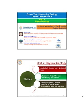
  • 1. 1 Course Title: Engineering Geology Course Code: EG453CE UNIT 7 Physical Geology Dr. Suman Manandhar, Dr. Eng. & PostDoc (Kyushu University) Visiting Faculty, School of Engineering, Department of Civil & Geomatic Engineering, Kathmandu University, NEPAL Visiting Associate Professor Institute of Lowland and Marine Research (ILMR), Saga University, JAPAN Former Secretary General cum Treasurer International Association of Lowland Technology (IALT), JAPAN Chief Guest Editor & Associate Editor Lowland Technology International Journal (LTI), JAPAN Unit 7: Physical Geology 2 Phases Geological Agents and Geological Cycle Geomorphological Process: Weathering and Erosion Geological Agents: Landform Produced By Glacier, River, Groundwater, Wind and Sea-water Suman Manandhar, Dr. Eng. (Geotechnical Engineering)
  • 2. 2 Geological Agents Suman Manandhar, Dr. Eng. (Geotechnical Engineering) 3 Suman Manandhar, Dr. Eng. (Geotechnical Engineering) 4
  • 3. 3 Suman Manandhar, Dr. Eng. (Geotechnical Engineering) 5 Suman Manandhar, Dr. Eng. (Geotechnical Engineering) 6
  • 4. 4 The Geological Cycle • Internal geologic processes – Generally build up the earth’s surface • External geologic processes – Generally wear down the earth’s surface – Driven directly or indirectly by sun and gravity • Weathering – Physical, Chemical, and Biological • Erosion – Wind – Flowing water – Human activities – Glaciers Suman Manandhar, Dr. Eng. (Geotechnical Engineering) 7 Source: Google Suman Manandhar, Dr. Eng. (Geotechnical Engineering) 8
  • 5. 5 9 Suman Manandhar, Dr. Eng. (Geotechnical Engineering) The upper part of the crust are in close interaction with the process of atmosphere, hydrosphere and biosphere. So mostly rocks are not stable and resistant. Source: Google
  • 6. 6 Weathering  Breakdown of earth materials due to various factors.  Disintegration or alteration of rock in its natural or original position at or near the Earth’s surface.  Weathering refers to the combination of processes that break up and corrode solid rock, eventually transforming it into sediment. Denudation • Weathering + Erosion +Transportation • Exposed or uncovered the rocks. • It is the process of breaking the earth’s surface by the help of external force, converted into loose soil and transport to other places. Source: Google 11 Suman Manandhar, Dr. Eng. (Geotechnical Engineering) Characteristics of weathering: • disintegration of rocks • chemical change in rocks • change in the surface of land • formation of soil due to change in temperature and weather. Source: Google 12 Suman Manandhar, Dr. Eng. (Geotechnical Engineering)
  • 7. 7 13 Weathering processes Micas  Vermiculite  Smectite  Kaolinite  Al,Fe-Oxides Young, weakly weathered soils = fine-grained mica, chlorite, vermiculite (Entisol, Inceptisol) Intermediate weathering = vermiculite,smectite, kaolinite (Mollisol,Alfisol, Ultisol) Strong weathering = kaolinite, hydrous oxides (Ultisol--> Oxisol) Suman Manandhar, Dr. Eng. (Geotechnical Engineering) 14 Suman Manandhar, Dr. Eng. (Geotechnical Engineering)
  • 8. 8  Physical or MechanicalWeathering  ChemicalWeathering  BiologicalWeathering  PhysicalWeathering  Processes that disintegration and decay of rocks via weather elements without altering its composition.  Takes place when rock is split or broken into smaller pieces of the same material without changing its composition • Abrasion or grinding • Freeze and thaw • Exfoliation (Sheet) • Frost action • Effect of Vegetation FrostWeathering 16 Suman Manandhar, Dr. Eng. (Geotechnical Engineering) Source: Google
  • 9. 9 Freeze andThawWeathering 17 Suman Manandhar, Dr. Eng. (Geotechnical Engineering) Source: Google Exfoliation • Weathering due to pressure release. • Outer layer of the rock expand more than inner layer and thin slabs of rock form and detached. Bed rock within the earth’s surface in under high pressure and temperature. When uplift and erosion brings bed rock to the surface, its temperature drop slowly while pressure drop immediately.The sudden drop cause the rock to rapidly expand and crack, this is due to pressure expansion and is called sheeting or exfoliation, the surface spalls off in layers. Source: Google
  • 10. 10 Effect of Vegetation Source: Google  ChemicalWeathering  Processes that change the chemical composition of rocks and minerals. It decomposes rocks through a chemical change in its minerals. • Dissolution • Carbonation • Oxidation • Hydrolysis • Hydration
  • 11. 11 • Water reacts with rock and helps in dissolving of minerals. • Water leads in dissolve minerals in the rock forming holes or voids. • Weathering by water. For instance, dissolving of sugar or salt (halite). 21 Dissolution Suman Manandhar, Dr. Eng. (Geotechnical Engineering) • Acidic water reacts with rock and helps in dissolving of minerals. • Acid react with water. • Water containing acid from dissolved carbon dioxide leads to dissolve minerals in the rock leaving cavities. (limestone caves). 22 Carbonation Suman Manandhar, Dr. Eng. (Geotechnical Engineering) Source: Google
  • 12. 12 • Iron combines with oxygen in the presence of water in a processes called oxidation. • The product of oxidation is rust. (rusting) 23 Oxidation Suman Manandhar, Dr. Eng. (Geotechnical Engineering) Source: Google • Water reacts with rock for a long time and the minerals dissolve forming clay which is also called as leaching. • Decomposition of rocks generally contains silicate minerals. • Silicate minerals generally formed clay due to hydrolysis. • Igneous rocks have much silica which readily combines with water. 24 Hydrolysis Suman Manandhar, Dr. Eng. (Geotechnical Engineering) Source: Google
  • 13. 13 25 Difference between Hydrolysis & Dissolution Suman Manandhar, Dr. Eng. (Geotechnical Engineering) • In this weathering the hydroxyl molecules are inserted into the molecular structures of minerals and decomposed. 26 Hydration Suman Manandhar, Dr. Eng. (Geotechnical Engineering) Source: Google
  • 14. 14  Biological Weathering Biological weathering takes place when rocks are broken down by living organisms.Trees and other plants can grow within the cracks in a rock formation. As the roots grow bigger they push open cracks in the rocks making them wider and deeper. Tiny organisms like bacteria, algae and moss can grow on rocks and produce chemicals which can break down the surface layer of the rock. Burrowing animals such as rabbits can accelerate the formation of cracks. • Action of plants and animals • Lichens (algae and fungi living as single unit) and mosses grow on rocks. • They wedge their tiny roots into spores and crevices. • When the roots grow, the rock splits. • Burrowing animals can increase weathering. Source: Google 28 Suman Manandhar, Dr. Eng. (Geotechnical Engineering)
  • 15. 15 • A part of rainfall always snips into the soil on the covered rocks and looses the rock particle by dissolving it. • Frost action also takes place in the pore spaces of rocks and causes disintegration and splitting of rocks into fragments. • Chemical reactions are also taking place in rocks internally and causing rock loosening. • Slow geological process of construction and destruction. Factors ofWeathering 29 Suman Manandhar, Dr. Eng. (Geotechnical Engineering) 1. Rock composition: There are certain elements which are included in rock composition. Some rocks will weather quickly and some slowly e.g. acidic rocks weather more quickly than basic ones. 2. Climate: It includes the meteorological elements effect on rocks such as moisture, temperature, and wind and air pressure. Climate determines whether physical or chemical weathering will be more active and speedy. 3.Topography Topography directly effects weathering by exposing rocks to the temperature or sun and wind. The elevated areas will be affected more and low level areas will be affected less. 4.Vegetation (Floral effect) Surface covered by the vegetation are protected from weathering but bare surfaces are weathered to great extent. Thin root plants protects weathering. Thick root plants accelerates weathering. 30 Suman Manandhar, Dr. Eng. (Geotechnical Engineering)
  • 16. 16 • Weathering gradually weakens rocks, and eventually produces new geological materials (rock fragments, sands, silts and clays) that are more stable in the new environment. • Weathering generally produces finer and less dense rock materials, and weaker, more porous and permeable rock masses. • In the tropics and subtropics, intense weathering in the hot and humid conditions produces thick weathered profiles, which may be up to 100 meters, or more, thick. Weathering Products 31 Suman Manandhar, Dr. Eng. (Geotechnical Engineering) ꝿ Destabilization of natural slope. ꝿ Removal of surface materials. ꝿ Formation of soil or sediment. ꝿ Chemical modification of soil. Impact of Weathering 32 Suman Manandhar, Dr. Eng. (Geotechnical Engineering) Agents of Weathering  Water  Wind  Glacial  Waves (Sea waves)  Under ground water
  • 17. 17 Difference between Weathering and Erosion Weathering - processes at or near Earth’s surface that cause rocks and minerals to break down Erosion - process of removing Earth materials from their original sites through weathering and transport 33 Suman Manandhar, Dr. Eng. (Geotechnical Engineering) Weathering Profile of Granitic Rock 34 Suman Manandhar, Dr. Eng. (Geotechnical Engineering) Source: Google
  • 18. 18 Engineering Classification of Weathering of Rocks 35 Suman Manandhar, Dr. Eng. (Geotechnical Engineering) Weathering classification suggested by ISRM Working Party, 1981. 36 Suman Manandhar, Dr. Eng. (Geotechnical Engineering)
  • 19. 19 Different stages of weathering of rocks and formation of soil. Suman Manandhar, Dr. Eng. (Geotechnical Engineering) 37 Source: Google The 5 Factors of Formation Soil is formed by… • Parent Material: the original “Mom & Pop” soil transported from elsewhere, usually by wind or water, at different speeds. • Climate: the amount, intensity, timing, and kind of precipitation that breaks down parts of ecosystem (i.e. rocks, trees) into soil. • Topography: Slope and Aspect affect the angle of the land and position toward/away from the sun that soil will be exposed to. • Biological: Plants, animals, microscopic organisms, and humans interact with soil in different ways. • Time: the amount of time it takes for the four factors (above) to interact with each other. 38 Suman Manandhar, Dr. Eng. (Geotechnical Engineering)
  • 20. 20 Soil Profile • A Soil Profile is a vertical cross-section of layers of soil found in a given area. Below are two examples of soil profiles. 39 Suman Manandhar, Dr. Eng. (Geotechnical Engineering) Source: Google Soil Horizon • Soil horizons are the layers in a soil profile used to classify soil types. • Horizons based on color, texture, roots, structure, rock fragments, and any unique characteristic worth noting. • Master Soil Horizons are depicted by a capital letter in the order (from top down): O, A, E, B, C, and R 40 Suman Manandhar, Dr. Eng. (Geotechnical Engineering)
  • 21. 21 O-Horizon The “Organic Matter” Horizon • Surface-layer, at depths of 0-2 feet • Dark in color, soft in texture • Humus - rich organic material of plant and animal origin in a stage of decomposition • Leaf litter – leaves, needles, twigs, moss, lichens that are not decomposing • Several O-layers can occur in some soils, consisting only of O-horizons 41 Suman Manandhar, Dr. Eng. (Geotechnical Engineering) Source: Google A-Horizon “Topsoil” or “Biomantle” Horizon • Topmost layer of mineral soil, at depths of 2-10 feet • Some humus present, darker in color than layers below • Biomantle - most biological productive layer; earthworms, fungi, and bacteria live this layer • Smallest and finest soil particles 42 Suman Manandhar, Dr. Eng. (Geotechnical Engineering)
  • 22. 22 E-Horizon The “Leaching Layer” Horizon • Small layer between A & B horizons • At depths of 10-15 feet • Light in color, mainly sand & silt • Poor mineral and clay content due to leaching – the loss of water-retaining plant nutrients to the water table • Soil particles larger than in A horizon but smaller than in B horizon 43 Suman Manandhar, Dr. Eng. (Geotechnical Engineering) Source: Google B-Horizon The “Subsoil” Horizon • At depths of 10-30 feet • Rich in clay and minerals like Fe & Al • Some organic material may reach here through leaching • Plant roots can extend into this layer • Red/brown in color due to oxides of Fe & clay 44 Suman Manandhar, Dr. Eng. (Geotechnical Engineering) Source: Google
  • 23. 23 C-Horizon The “Regolith” Horizon • At depths of 30-48 feet • Made up of large rocks or lumps of partially broken bedrock • Least affected by weathering and have changed the least since their origin • Devoid of organic matter due to it being so far down in the soil profile 45 Suman Manandhar, Dr. Eng. (Geotechnical Engineering) R-Horizon The “Bedrock” Horizon • At depths of 48+ feet • Deepest soil horizon in the soil profile • No rocks or boulders, only a continuous mass of bedrock • Colors are those of the original rock of the area 46 Suman Manandhar, Dr. Eng. (Geotechnical Engineering) Source: Google
  • 24. 24 • Fast moving water has a lot of energy and can carry larger pieces of rocks and sediments. • Slow moving water has less energy and can only carry tiny particles of sediment. • When water loses energy, the sediments settle out. • Water has the ability to move materials over long distances. Erosion by water, is carried out mainly by 2 factors: • Rainwater (Rainfall) • Running water (River) Erosion by Water 47 Suman Manandhar, Dr. Eng. (Geotechnical Engineering) 48 Suman Manandhar, Dr. Eng. (Geotechnical Engineering) Source: Google
  • 25. 25 Process of erosion due to rainfall • Splash erosion – Initial or the first stage of erosion. – It mainly occurs when rain drops hit the surface and uppermost layer wash away. – Transportation of loose material comparatively very less. • Sheet erosion – Sheet erosion is transportation of loose soil particles by overland flow. – Removal of uniform/thin layer of soil from the soil surface. – It occurs in shallow depth. 49 Suman Manandhar, Dr. Eng. (Geotechnical Engineering) Source: Google 50 Suman Manandhar, Dr. Eng. (Geotechnical Engineering) Source: Google
  • 26. 26 Process of erosion due to rainfall • Rill erosion – Runoff water form small channels and that channels wash away soil with them. – Rills are shallow drainage lines less than 30 cm deep. • Gully erosion – Gullies are channels deeper than 30 cm. – When rills become more deep and wide, gully formed. – Erosion that occurs when rills meets together, widen and deepen. – Gully erosion can be defined as detachment and removal of soil in large mass comparative to others. 51 Suman Manandhar, Dr. Eng. (Geotechnical Engineering) Source: Google Development or Formation of Gullies The gully development is recognized in four stages: • Formation Stage: Scouring of top soil in the direction of general slope occurs as the runoff water concentrates. It normally proceeds slowly where the top soil is fairly resistant to erosion. • Development Stage: Causes upstream movement of the gully head and enlargement of the gully in width and depth. The parent materials are removed rapidly as water flows. • Healing Stage:Vegetation starts growing in the gully. • Stabilization Stage: Gully reaches a stable gradient, gully walls attain a stable slope and sufficient vegetation cover develops over the gully surface to anchor the soil and permit development of new topsoil. 52 Suman Manandhar, Dr. Eng. (Geotechnical Engineering)
  • 27. 27 Classification of Gullies 1. Based on size 53 Suman Manandhar, Dr. Eng. (Geotechnical Engineering) 2. Based on Shape U-Shaped: These are formed where both the topsoil and subsoil have the same resistance against erosion. Because the subsoil is eroded as easily as the topsoil, nearly vertical walls are developed on each side of the gully. V-Shaped: These gullies develop where the subsoil has more resistance than topsoil against erosion. This is the most common form of gully. Trapezoidal:These gullies are formed where the gully bottom is made of more resistant material than the topsoil. Below the bottom of gully, the subsoil layer has much more resistance to get eroded and thus the development of further depth of gully is restricted. 54 Suman Manandhar, Dr. Eng. (Geotechnical Engineering) Source: Google
  • 28. 28 Factors affecting Gully erosion • Intense rainfall • Topography • Urbanization or improper land management • Over grazing • Construction of new road without planning (Haphazardly) • Mining activities 55 Suman Manandhar, Dr. Eng. (Geotechnical Engineering) Erosion due to running water While talking about erosion due to running water (rivers/streams), generally two types of erosion can be observed: • Bank erosion • Base scouring 56 Suman Manandhar, Dr. Eng. (Geotechnical Engineering) Source: Google
  • 29. 29 57 River Systems & the Work of Rivers River system is a larger system of rivers and its tributaries. These are the streams of water which is flowing through a particular channels. Groups of these streams together called a river system. The lowest level to which a river can erode its bed is called base level. Sea level is the ultimate base level, but the floor of a lake or basin into which a river flows may become local and temporary base level. There are 4 types of River Systems: 1. Braided Rivers 2. Meandering Rivers 3. Anastomosing Rivers 4. Straight Rivers Suman Manandhar, Dr. Eng. (Geotechnical Engineering) 58 1. Braided Rivers: Braided streams typically get their start when a central sediment bar begins to form in a channel due to reduced streamflow or an increase in sediment load. These channels are constituting ripple crossed bedded sands. These channels are active during flood stage and these can produce the cross beds in larger scales. The sediments formed are pebbly and sandy in nature. Source: Google Suman Manandhar, Dr. Eng. (Geotechnical Engineering)
  • 30. 30 59 2. Meandering Rivers: These are formed in coastal areas, lower gradient. Because of the continuous flow, fine sediments were seen. In inner bends of meanders cross laminated sands are constructed. Channels are seperated by levees from flood plains that are comprised of finer grained muds and sands deposited after breach of levees during flood stage, usually vegetated. Flood stage can lead to cut off of meanders and break through of river. Source: Google Suman Manandhar, Dr. Eng. (Geotechnical Engineering) 60 3.Anastomosing Rivers: Anastomosed streams form when the downstream base level rises, causing a rapid buildup of sediment. Since bank materials are not easily erodible, the original single-thread stream breaks up into multiple channels. Streams entering deltas in a lake or bay are often anastomosed. Most often they seem to form under relatively low energetic conditions near a base level. It appears to be impossible to define anastomosing rivers unambiguously on the basis of channel planform only. It can be defined as an anastomosing river is composed of two or more interconnected channels that enclose flood basins. Source: Google Suman Manandhar, Dr. Eng. (Geotechnical Engineering)
  • 31. 31 61 3. Straight Rivers: Straight river is generally regarded as one of the typical river patterns in conventional classifications in terms of their channel plain land forms. However, very few straight patterns were found to be distributed in wider spatial and temporal spans in the self adjusted fluvial rivers. Source: Google Suman Manandhar, Dr. Eng. (Geotechnical Engineering) 62 After Miall (1977) Source: Google Suman Manandhar, Dr. Eng. (Geotechnical Engineering)
  • 32. 32 63 The Work of Rivers The erosional work of streams/rivers carves and shapes the landscape through which they flow. Functions of rivers: a. Erosion b. Transportation c. Deposition The work of a river depends on its energy. Energy a function of: a. Volume of water b. Speed of water flow (dependent on gradient) Suman Manandhar, Dr. Eng. (Geotechnical Engineering) 64 Source: Google Suman Manandhar, Dr. Eng. (Geotechnical Engineering)
  • 33. 33 65 Source: Google Suman Manandhar, Dr. Eng. (Geotechnical Engineering) 66 Suman Manandhar, Dr. Eng. (Geotechnical Engineering)
  • 34. 34 67 Source: Google Suman Manandhar, Dr. Eng. (Geotechnical Engineering) 68 Youth stage = Upper course Mature stage = Middle course Old stage = Lower course Source: Google Suman Manandhar, Dr. Eng. (Geotechnical Engineering)
  • 35. 35 69 Three stages of river: A river rises from the highest level of the ground, called source. When the river flows downwards through the slope, it is said to be course. Finally it reaches/meets the sea/ocean called mouth. Three stages may occur in the path (course) of the river. The upper part is called youthful stage, the middle is called mature stage and the lower is called old age stage. Source: Google Suman Manandhar, Dr. Eng. (Geotechnical Engineering) 70 Source: Google Suman Manandhar, Dr. Eng. (Geotechnical Engineering)
  • 36. 36 71 Process of erosion: 1. Hydraulic action It is the work of turbulence in the water. In other words it is force of moving water. Running water causes friction in the joints of rocks in a stream channel. It breaks fragments of the river bed and the banks of the river. These fragments are carried along by the river which is called load. Source: Google Suman Manandhar, Dr. Eng. (Geotechnical Engineering) 2. Abrasion/corrosion When a load is carried by the river, the load hits against its bed and the sides (banks) of the river (i.e. bounced and dragged). As a result, bed and bank materials started to pluck out and erodes rapidly. Abrasion is the most powerful process of river erosion. 72 Source: Google Suman Manandhar, Dr. Eng. (Geotechnical Engineering)
  • 37. 37 3.Attrition When particles of the load themselves break into smaller pieces (worn down), the process is said to be attrition. When thrown against the bed and banks of the rivers, shapes of load turned into rounded and the edges of the load changes to smooth. 73 Source: Google Suman Manandhar, Dr. Eng. (Geotechnical Engineering) 4. Solution/Corrosion When chemicals in the water dissolves certain minerals in rocks, it is said to be solution. For example, carbonic acid slowly dissolves limestone. 111 Source: Google Suman Manandhar, Dr. Eng. (Geotechnical Engineering)
  • 38. 38 112 Source: Google Suman Manandhar, Dr. Eng. (Geotechnical Engineering) 76 1.Traction 2. Saltation (Bounce) 3. Suspension 4.Solution Transportation Source: Google Suman Manandhar, Dr. Eng. (Geotechnical Engineering)
  • 39. 39 1.Traction Larger and heavier rocks/gravels are dragged or rolled along the bed. 2. Saltation (saltism: by leaps/jumps) Smaller and lighter rock fragments and sand hop and bounce along the river bed. At times, the distinction between traction and saltation may be difficult to determine. 3. Suspension Some of the load like silt and clay (fine-grained) will float along. They may only be deposited when stream velocity reaches near 0. Turbulence in the water is crucial in holding a load of sediments. 4. Solution Some minerals are transported in dissolved form. Especially chemical solution derived from minerals like limestone or dolomite. 77 Suman Manandhar, Dr. Eng. (Geotechnical Engineering) 78 Deposition When the river looses its ability to carry sediments/loads, it will suddenly drops the materials on the bed and sides of the river. The phenomenon is called deposition. Suman Manandhar, Dr. Eng. (Geotechnical Engineering)
  • 40. 40 79 River’s volume decreases • Presence of permeable rocks • Receding flood waters River’s speed decreases • It enters a lake • It enters a calm sea • It enters a gently sloping plain Suman Manandhar, Dr. Eng. (Geotechnical Engineering) 80 Youth stage • V-shaped valleys • Interlocking Spurs • Waterfalls Mature stage • Meanders • Ox-bow lakes Old age stage • Deltas • Levees • Flood Plains Features of Stages of rivers Suman Manandhar, Dr. Eng. (Geotechnical Engineering)
  • 41. 41 81 Hjulstrom curve Suman Manandhar, Dr. Eng. (Geotechnical Engineering) Source: Google 82 Source: Google Suman Manandhar, Dr. Eng. (Geotechnical Engineering)
  • 42. 42 83 Erosional Features of Rivers Suman Manandhar, Dr. Eng. (Geotechnical Engineering) Types of Erosional Features  V-shaped RiverValley  Gorge and Canyon  River Meanders  RiverTerraces  Waterfall  Pothole 84 Suman Manandhar, Dr. Eng. (Geotechnical Engineering) Types of Erosional Features V-shaped RiverValley The valleys sculptured by the rivers forming deep and narrow in a way to valley sides meet each other at the valley floor. The valley formed in the youth stage of fluvial erosion with steep valley side slope of convex element and developedV-shaped. Source: Google
  • 43. 43 85 Suman Manandhar, Dr. Eng. (Geotechnical Engineering) Types of Erosional Features Gorge and Canyon It represents very deep and narrow valleys incorporating very steep valley side slope. It is formed through a long period of time with frequent erosions. Kaligandaki gorge, Mustang District (Source: Google) 86 Suman Manandhar, Dr. Eng. (Geotechnical Engineering) Types of Erosional Features River Meanders River meander refers to the bends or longitudinal courses of the river, shape formed as the movement of a snake. The shape is usually circular but sometimes it becomes semi- circular. The concave slope is formed by the channel where river strikes and erosion takes place resulting the formation of vertical cliffs. On the other hand, the convex slope is characterized by gentle slope due to deposition of sands and gravels but sometimes alluvium is deposited. River Meander (Source: Google)
  • 44. 44 87 Suman Manandhar, Dr. Eng. (Geotechnical Engineering) Types of Erosional Features RiverTerraces The narrow flat surface on either side of the valley floor are known as river terrace. They are produced due to the dissection of fluvial sediments of flood plains deposited along the valley floor. Layers of terraces are formed as stepped structures indicating terraces of different time period along the valley floor. RiverTerrace (Source: Google) 88 Suman Manandhar, Dr. Eng. (Geotechnical Engineering) Types of Erosional Features Waterfall A vertical drop of water with high energy occupying large volume of water from the great height along the longer profile of the river. Nyarchang waterfall, Myagdi (Source: Google)
  • 45. 45 89 Suman Manandhar, Dr. Eng. (Geotechnical Engineering) Types of Erosional Features Pothole A kettle-like small depressions in the rock beds of the river valleys are termed as “potholes” forming a cylindrical shape. It is formed in the upper course of a river causing erosion due to high potential energy with increasing diameter and depth. It is generally formed in coarse-grained rocks, for instance, sandstones and granite. Pothole (Source: Google) 90 Depositional Features of Rivers Suman Manandhar, Dr. Eng. (Geotechnical Engineering) Types of Depositional Features Alluvial Fan and Alluvial Cone Alluvial fand and alluvial cone are formed at the base of foothill where there is abrupt drop in the channel gradient.Alluvial fan is gently sloped (averaged 5०) compared to alluvial cone (averaged about 15०). Alluvial cones are characterized with the presence of relatively coarse grained materials than the alluvial fans. Source: Google Fan Cone
  • 46. 46 91 Suman Manandhar, Dr. Eng. (Geotechnical Engineering) Types of Depositional Features Oxbow Lake An oxbow lake forms when a meandering river erodes through the neck of one of its meanders.This takes place because meanders tend to grow and become more curved over time.The river then follows a shorter course that bypasses the meander. Oxbow Lake (Source: Google) 92 Suman Manandhar, Dr. Eng. (Geotechnical Engineering) Types of Depositional Features Natural Levees The narrow belt of ridges of low height parallel to the channel built by the deposition of the sediments are termed as natural levees, and it limits the lateral spread of the river water. Natural Levee (Source:Google)
  • 47. 47 93 Suman Manandhar, Dr. Eng. (Geotechnical Engineering) Types of Depositional Features Flood Plain An area of flat land near the river often subjected to flooding. It is an area of low-lying surface ground adjacent to the river constituted mainly the river sediments. Floodplain (Source:Google) 94 Suman Manandhar, Dr. Eng. (Geotechnical Engineering) Types of Depositional Features Delta The triangular shaped depositional feature at the mouth of a river debouncing in a lake and/or sea is delta. It constitutes medium-sized sediments. Delta (Source: Google)
  • 48. 48 Erosional Features of Glaciers 95 Suman Manandhar, Dr. Eng. (Geotechnical Engineering) Types of Erosional Features  Striations  U-ShapedValley  HangingValley  Cirques &Tarns  Horn  Fjords  Aretes • Ice moves and carries rocks, grinding the rocks beneath it. • Plucking happens when materials are picked up by the moving ice and pushed along by the glacier. • During abrasion, smaller rocks act like large pieces of sand paper and cause grooves to be carved into the land. 96 Suman Manandhar, Dr. Eng. (Geotechnical Engineering) Types of Erosional Features Striations (Source: Google) Erosion resulted surface material is washed out by glacial activity and rock fragments are carried out by abrasion formed scratches and polished on underlying bedrock pavement, called glacial striations.
  • 49. 49 97 Suman Manandhar, Dr. Eng. (Geotechnical Engineering) Types of Erosional Features U-ShapedValleys (Source: Google) 98 Suman Manandhar, Dr. Eng. (Geotechnical Engineering) Types of Erosional Features Horns Horns (Source: Google)
  • 50. 50 99 Suman Manandhar, Dr. Eng. (Geotechnical Engineering) Types of Erosional Features Cirques &Tarns Cirques &Tarns (Source: Google) Depositional Features of Glaciers 100 Suman Manandhar, Dr. Eng. (Geotechnical Engineering) Types of Depositional Features  Till  Moraine  Outwash Plains  Kettleholes  Drumlins  Kame Source: Google
  • 51. 51 101 Suman Manandhar, Dr. Eng. (Geotechnical Engineering) Types of Depositional Features Till Source: Google • Till is a form of glacial drift, which is rock material transported by a glacier and deposited directly from the ice or from running water emerging from the ice. It is distinguished from other forms of drift in that it is deposited directly by glaciers without being reworked by meltwater. 102 Suman Manandhar, Dr. Eng. (Geotechnical Engineering) Types of Depositional Features Moraine Source: Google • A moraine is material left behind by a moving glacier. This material is usually soil and rock. Just as rivers carry along all sorts of debris and silt that eventually builds up to form deltas, glaciers transport all sorts of dirt and boulders that build up to form moraines.There are four types of moraines. Types of Moraines:  Lateral Moraines  Medial Moraines  Terminal Moraines  Supraglacial Moraines  Ground Moraines
  • 52. 52 103 Suman Manandhar, Dr. Eng. (Geotechnical Engineering) Types of Depositional Features Source: Google Types of Moraines:  Lateral Moraines: Unsorted glacial deposits along the sides of a glacier which are formed parrallel to the ridges are termed as lateral moraines. 104 Suman Manandhar, Dr. Eng. (Geotechnical Engineering) Types of Depositional Features Source: Google Types of Moraines:  Medial Moraines: Medial moraines form where two tributary glaciers come together. They are generally surficial features on the ice and often consist of rock that has fallen from a rockwall where the glaciers converge. Because they are thin, surficial features, medial moraines are rarely preserved after the ice retreats..
  • 53. 53 105 Suman Manandhar, Dr. Eng. (Geotechnical Engineering) Types of Depositional Features Source: Google Types of Moraines:  Terminal Moraines: A terminal moraine, also called end moraine, is a type of moraine that forms at the terminal (edge) of a glacier, marking its maximum advance. 106 Suman Manandhar, Dr. Eng. (Geotechnical Engineering) Types of Depositional Features Source: Google Types of Moraines:  Supraglacial Moraines: A supraglacial moraine is enunciated of when the surface of a glacier is covered with debris and/or boulders. A supraglacial moraine can cover a glacier completely or only partially in the area of the glacier tongue. The photos below show different variants.
  • 54. 54 107 Suman Manandhar, Dr. Eng. (Geotechnical Engineering) Types of Depositional Features Source: Google Types of Moraines:  Ground Moraines: Ground moraines are till-covered areas with irregular topography and no ridges, often forming gently rolling hills or plains, with relief of less than 10 meters (33 ft). Ground moraine is accumulated at the base of the ice. 108 Suman Manandhar, Dr. Eng. (Geotechnical Engineering) Types of Depositional Features Outwash Plains Source: Google • An outwash plain, also called a sandur (plural: sandurs), sandr or sandar, is a plain formed of glaciofluvial deposits due to meltwater outwash at the terminus of a glacier.
  • 55. 55 109 Suman Manandhar, Dr. Eng. (Geotechnical Engineering) Types of Depositional Features Kettle holes Source: Google • A kettle (also known as a kettle lake, kettle pond, kettle hole, or pothole) is a depression or hole in an outwash plain formed by retreating glaciers or draining floodwaters. The kettles are formed as a result of blocks of dead ice left behind by retreating glaciers, which become surrounded by sediment deposited by meltwater streams as there is increased friction 110 Suman Manandhar, Dr. Eng. (Geotechnical Engineering) Types of Depositional Features Drumlins Source: Google • A drumlin, from the Irish word droimnín ("little ridge"), first recorded in 1833, in the classical sense is an elongated hill in the shape of an inverted spoon or half-buried egg formed by glacial ice acting on underlying unconsolidated till or ground moraine.
  • 56. 56 111 Suman Manandhar, Dr. Eng. (Geotechnical Engineering) Types of Depositional Features Kame Source: Google • A kame, or knob, is a glacial landform, an irregularly shaped hill or mound composed of sand, gravel and till that accumulates in a depression on a retreating glacier, and is then deposited on the land surface with further melting of the glacier. Kames are often associated with kettles, and this is referred to as kame and kettle or knob and kettle topography. Erosional Features of Groundwater 112 Suman Manandhar, Dr. Eng. (Geotechnical Engineering) Types of Erosional Features  Sinkhole  Cavern  Karst topography  Solution valley  Stylolite Source: Google
  • 57. 57 113 Suman Manandhar, Dr. Eng. (Geotechnical Engineering) Types of Erosional Features Sinkhole (Source: Google) A sinkhole is a depression or hole in the ground caused by some form of collapse of the surface layer.The term is sometimes used to refer to doline. Most sinkholes are caused by karst processes – the chemical dissolution of carbonate rocks, collapse or suffusion processes. (Sinkhole in Nadipur,Pokhara, Source: Kathmandu Post) 114 Suman Manandhar, Dr. Eng. (Geotechnical Engineering) Types of Erosional Features Cavern (Gupteshwor Mahadev Cave, Pokhara, Source: Google) A cave or cavern is a natural void in the ground, specifically a space large enough for a human to enter. Caves often form by the weathering of rock and often extend deep underground. Caves are often ornamented with calcium carbonate formations produced through slow precipitation.These include flowstones, stalactites, stalagmites, helictites, soda straws and columns.
  • 58. 58 115 Suman Manandhar, Dr. Eng. (Geotechnical Engineering) Types of Erosional Features KarstTopography (Source: Google) Karst is a topography formed from the dissolution of soluble rocks such as limestone, dolomite, and gypsum. It is characterized by underground drainage systems with sinkholes and caves. 116 Suman Manandhar, Dr. Eng. (Geotechnical Engineering) Types of Erosional Features Solution valley (Source: Google) The collapse of a cavern over a large area can create a feature referred to as a solution valley or basin, sometimes referred to as a karst gulf, which from the air resembles a huge sinkhole.These depressions may reach hundreds of meters across and may contain numerous smaller, local sinkholes.
  • 59. 59 117 Suman Manandhar, Dr. Eng. (Geotechnical Engineering) Types of Erosional Features Stylolite (Source: Google) Stylolite, secondary (chemical) sedimentary structure consisting of a series of relatively small, alternating, interlocked, toothlike columns of stone; it is common in limestone, marble, and similar rock. Depositional Features of Groundwater 118 Suman Manandhar, Dr. Eng. (Geotechnical Engineering) Types of Depositional Features  Stalactites & Stalagmites  Replacement deposit  Dripstone column
  • 60. 60 119 Suman Manandhar, Dr. Eng. (Geotechnical Engineering) Types of Depositional Features Stalactites & Stalagmites (Source: Google) Stalactite and stalagmite, elongated forms of various minerals deposited from solution by slowly dripping water. A stalactite hangs like an icicle from the ceiling or sides of a cavern. A stalagmite appears like an inverted stalactite, rising from the floor of a cavern. Stalactite Stalagmites 120 Suman Manandhar, Dr. Eng. (Geotechnical Engineering) Types of Depositional Features Replacement deposit (Source: Google) Rocks are dissolved due to groundwater activities leaving behind a new mineral deposit as a replacement is termed as replacement deposit.
  • 61. 61 121 Suman Manandhar, Dr. Eng. (Geotechnical Engineering) Types of Depositional Features Dripstone columns (Source: Google) These structures form when limestone dissolves a little in water. As that water flows through cracks in the rock, it leaves behind traces of what's dissolved in it – slowly building up on the ceiling and the floor. Eventually, a stalactite and stalagmite will grow together into a single column (connects in a single column). Erosional Features of Wind/Aeolin 122 Suman Manandhar, Dr. Eng. (Geotechnical Engineering) Types of Erosional Features  Ventifacts  Yardangs  Deflation Hollows  Pedestal Rock • Erosion by abrasion may occur as particles come in contact with solid objects. • Small sediments can be carried in the air by the wind. • Larger sediments can be rolled along the ground.
  • 62. 62 123 Suman Manandhar, Dr. Eng. (Geotechnical Engineering) Types of Erosional Features Ventifacts (Source: Google) Ventifacts are rocks that have been sculpted by wind-borne particles (Bridges et al. 1999) and worn, faceted, cut, or polished by the abrasive action of windblown sand, usually under arid conditions, in areas subject to frequent, high-velocity, sand-laden winds. 124 Suman Manandhar, Dr. Eng. (Geotechnical Engineering) Types of Erosional Features Yardangs (Source: Google) A yardang is a streamlined bump carved from bedrock or any consolidated or semi-consolidated material by the dual action of wind abrasion by dust and sand and deflation (the removal of loose material by wind turbulence).
  • 63. 63 125 Suman Manandhar, Dr. Eng. (Geotechnical Engineering) Types of Erosional Features Deflation Hollows (Source: Google) Dune deflation hollows are where wind has removed sand down to a level where a layer of particles too heavy for the wind to move (an armored surface) stabilizes the sand and prevents the surface being lowered further. 126 Suman Manandhar, Dr. Eng. (Geotechnical Engineering) Types of Erosional Features Pedestal Rock (Source: Google) A mushroom rock, also called rock pedestal, or a pedestal rock, is a naturally occurring rock whose shape, as its name implies, resembles a mushroom. The rocks are deformed in a number of different ways: by erosion and weathering, glacial action, or from a sudden disturbance. Mushroom rocks are related to, but different from, yardang.
  • 64. 64 Depositional Features of Wind/Aeolin 127 Suman Manandhar, Dr. Eng. (Geotechnical Engineering) Types of Depositional Features  Sand Dunes  Loess  Sand Sheets 128 Suman Manandhar, Dr. Eng. (Geotechnical Engineering) Types of Depositional Features Sand Dunes (Source: Google) A dune is a mound of sand this is formed by the wind, usually along the beach or in a desert. Dunes form when wind blows sand into a sheltered area behind an obstacle. Barchans, Transverse, Parabolic and Longitudinal Dunes are the types of sand dunes.
  • 65. 65 129 Suman Manandhar, Dr. Eng. (Geotechnical Engineering) Types of Depositional Features Sand Dunes (Source: Google) Barchans Dune: A barchan or barkhan dune is a crescent- shaped dune. Transverse Dunes: Abundant barchan dunes may merge into barchanoid ridges, which then grade into linear (or slightly sinuous) transverse dunes, so called because they lie transverse, or across, the wind direction, with the wind blowing perpendicular to the ridge crest. 130 Suman Manandhar, Dr. Eng. (Geotechnical Engineering) Types of Depositional Features Sand Dunes (Source: Google) Parabolic Dune: U-shaped mounds of sand with convex noses trailed by elongated arms are parabolic dunes. These dunes are formed from blowout dunes where the erosion of vegetated sand leads to a U-shaped depression. Longitudinal Dunes: Seif dunes are linear (or slightly sinuous) dunes with two slip faces. The two slip faces make them sharp-crested. They are called seif dunes after the Arabic word for "sword". They may be more than 160 kilometres (100 miles) long
  • 66. 66 131 Suman Manandhar, Dr. Eng. (Geotechnical Engineering) Types of Depositional Features Loess (Source: Google) Loess (from German: Löss ) is a clastic, predominantly silt- sized sediment that is formed by the accumulation of wind- blown dust. 10% of Earth's land area is covered by loess or similar deposits . 132 Suman Manandhar, Dr. Eng. (Geotechnical Engineering) Types of Depositional Features Sand Sheets (Source: Google) Sand sheets are flat, gently undulating plots of sand surfaced by grains that may be too large for saltation. They form approximately 40% of aeolian depositional surfaces.
  • 67. 67 Erosional Features of Coast/Sea Water 133 Suman Manandhar, Dr. Eng. (Geotechnical Engineering) Types of Erosional Features  Cliffs &Wave Cut Bench  Headlands & Bays 134 Suman Manandhar, Dr. Eng. (Geotechnical Engineering) Types of Erosional Features Cliffs &Wave Cut Bench (Source: Google) When the sea moves against the base of the cliff (headlands) using corrasion and hydraulic action (for e.g., limestone or chalk), it undercuts the cliff and forms a wave-cut notch. Above this notch, an overhang will form; it will fall into the sea as a result of the pressure of its own weight and the pull of gravity. This phenomena will continue and form another notch with retreating the cliff and form higher and steep cliff rock. Hence formed remains of the cliff rock, now below the sea at high tide, form a rocky cliff.
  • 68. 68 135 Suman Manandhar, Dr. Eng. (Geotechnical Engineering) Types of Erosional Features Headlands & Bays (Source: Google) The bands of soft rock, such as sand and clay, erode more quickly than those of more resistant rock, such as chalk. This leaves a section of land jutting out into the sea called a headland. The areas where the soft rock has eroded away, next to the headland, are called bays. 136 Suman Manandhar, Dr. Eng. (Geotechnical Engineering) Types of Erosional Features Caves,Arch, Stack & Stump (Source: Google) When a wave-cut notch collapses in time due to gravity, it leaves behind a column of rock not attached to the cliff, known as stack. The continuous erosion & weathering will lead to the formation of stump, visible only at low tide.
  • 69. 69 137 Suman Manandhar, Dr. Eng. (Geotechnical Engineering) Types of Erosional Features Caves,Arch, Stack & Stump (Source: Google) Caves occur when waves force their way into cracks in the cliff face. The water contains sand and other materials that grind away at the rock until the cracks become a cave (e.g., hydraulic action). If the cave is formed in a headland, it may eventually break through to the other side forming an arch. Depositional Features of Coast/Sea Water 138 Suman Manandhar, Dr. Eng. (Geotechnical Engineering) Types of Depositional Features  Beach  Spits  Sand Bars  Abyssal Plain  Coral Reefs  Atoll (Source: Google) Assignment 27 march, 2023
  • 70. 70 • Downward movement of rock and sediment down a slope due to the pull of gravity • The process is quite slow and almost impossible to see until the land mass is no longer able to support itself and falls or slides down a slope. Erosion by Gravity 139 Suman Manandhar, Dr. Eng. (Geotechnical Engineering) 140 Suman Manandhar, Dr. Eng. (Geotechnical Engineering)
  • 71. 71 Thank you for your kind attention !!!