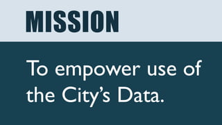
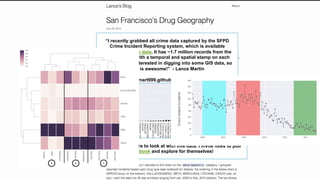
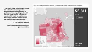
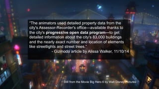
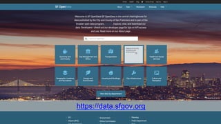
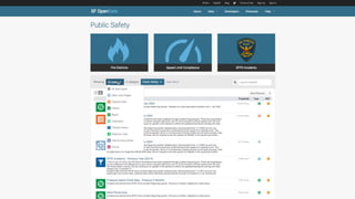
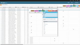
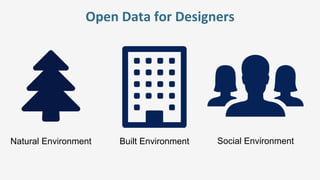
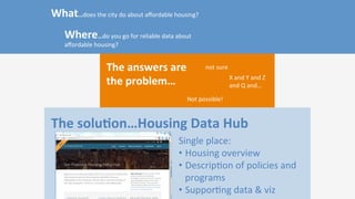
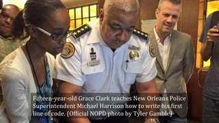
This is Jason Lally's presentation about open data for designers, which she gave during the webinar on the same subject matter. Found here: http://www.openarchcollab.org/webinar02_opendata_page
This document provides a summary of the best local sources for research. It lists 13 sources for local economic and demographic data, including the American FactFinder, QWI Explorer, Bureau of Labor Statistics, Bureau of Economic Analysis, Eurostat, YourEconomy.org, MetroTrends.org, SBA SizeUp Widget, ReferenceUSA, Moody's Analytics, cost of living comparisons, and ResearchOnMainStreet.com. For each source, it provides a brief description of the type of data available and how to access the information.
From Global to Local: Mobile, Mapping and ActionChristian Kreutz
Location, mobile phones and the Internet, combined together, are becoming an attractive amalgam for new opportunities. There is a fascinating trend to see the convergence of mobile technologies connected to the Internet and the rising importance of location. This is not just another hype, but could really be interesting for the non-profit arena.
This is Theresa Hwang's presentation from a Webinar produced by the Open Architecture Collaborative and the Association for Community design entitled "Defining your focus - assessment tools"
This is the basic story of the the Architecture for Humanity Chapter Network became the Open Architecture Collaborative and how we are moving forward with a different, bottom up strategy.
This document discusses how data can be used to inform design decisions. It notes that 20% of design decisions impact 80% of a project's performance. It also provides statistics on US carbon emissions and energy consumption by sector, with buildings accounting for nearly half of both. The document encourages using data to reduce emissions, be sensitive to land use and communities, track changes over time, and collaborate across disciplines.
This document provides an overview of the Chapter Network organization including:
- A list of locations where chapters are located globally.
- Descriptions of selected current projects in Detroit, Chicago, London, and New Orleans focusing on community engagement and design work.
- Information on resilience programs in San Francisco and Portland centered around disaster preparedness and building social networks.
- Details of a transitional steering committee focused on collective decision making, developing new structures, and hiring support to take the network to the next level over the next two years.
A Data Scientist Exploration in the World of Heterogeneous Open Geospatial DataGloria Re Calegari
We present the challenges faced by a Data Scientist in exploring and analyzing heterogeneous Open Geospatial Data. This work is aimed at explaining the initial steps of a data exploration process, specifically aimed at discovering similarities and differences conveyed by diverse sources and resulting from their correlation analysis; we also explore the influence of spatial resolution on the dependence strength between heterogeneous urban sources, to pave the way to a meaningful information fusion.
The document discusses the challenges posed by smartphones and their applications for mobile network operators. It notes how data usage and signaling from smartphones has grown exponentially in recent years, overloading some networks. Other topics covered include how different platforms have different signaling needs, attempts to manage traffic through throttling and volume limits, how most mobile data usage occurs in fixed locations, and the need for intelligent traffic management and new business models to handle continued growth profitably.
New digital tools for investigative journalism aajaGannett
This document discusses new digital tools for investigative journalism such as social network analysis, maps, interactive graphics, embedding documents, data visualization, crowdsourcing, and timelines. It provides examples of how newspapers like USA Today, Washington Post, New York Times, Texas Tribune, and others have used these tools in their investigative reporting projects. The tools allow journalists to generate story foundations, simply depict information for readers, see nuances and relationships between data and places, and bring complicated stories to life for audiences.
Tim willoughby - Presentation to Open IrelandTim Willoughby
Tim Willoughby explains the benefits of open government and open data. He advocates for making government data openly available in standardized, machine-readable formats and developing applications that leverage open data. While open data faces challenges including loss of control and fear of the unknown, its benefits include more informed decisions, higher quality data, and new business opportunities through opening up data.
Snap4City a Solution for highly collaborative Smart Cities Environments Paolo Nesi
Snap4City has been created in response to Select4Cities PCP (http://www.select4cities.eu/) call as an open, standardized, data-driven, service-oriented, user-centric platform enabling large-scale co-creation IOT/IOE applications and services for Helsinki, Copenhagen and Antwerp. Snap4City is a fully open source, robust, scalable, easy to use solution, provides tools for co-creation of mixt data driven, stream and batch processing, extending the powerful semantic reasoner of Km4City https://www.km4city.org, with IOT/IOE, GDPR, and city dashboards. Snap4City (Https://www.snap4city.org ) is a solution for setting up Living Labs engaging different all kinds of stakeholders (city operators, researchers, city users, in house, industries) in contributing to the city evolutions, with a platform providing online tools for developing IOT applications, web and mobile Apps, data analytics, micro Applications, external services, KPI, POI, dashboards, IOT edge, etc.
Snap4City/Km4City has been validated in multiple devices (PC, Android, Raspberry, IOT Button, Arduino, ..), and domains: mobility and transport, tourism, health, welfare, social and cities such as Florence, Pisa, Arezzo, and large area of millions on inhabitants as Tuscany and millions of data per day. The innovation is mainly related to semantic reasoning, IOT interoperability, microservices, automated dashboard production, end-2-end encrypted secure communications, GDPR, .. thus setting up in a Snap smart city solutions.
Snap4City November 2019 Course: Smart City IOT Geernal overview, from dashboa...Paolo Nesi
• Overview
• Urban Platform (main concepts vs Living Lab)
• Snap4City Architecture, roadmap, logos, innovations
• Dashboards: from City Dashboards to Applications
• Trajectories and real time tracking
• Dashboards Intelligence and web and mobile devices
• Dashboard chatrooms and notifications
• Smart City Control Room
• Dashboards production
• Data Gathering and City Data Knowledge Management
• Protocol vs Data
• Data Gathering processes
• GIS Data Import, Export and Exploitation
• Semantic Modeling and City Knowledge Base: Km4CIty
• IOT Applications, Devices and Dashboards
• IOT Devices
• Forging & Managing Flexible Mobile Apps, Web App, MicroApplications
• Web and Mobile App with Open Development Kit
• Understanding how city users are using the city services
• Engaging City Users Towards Virtuous Behaviour
• Data Analytic, Big Data Science
• Data Analytics: predictions
• Smart Parking: predictions
• User behaviour Analysis via Wi-Fi, OD Matrices, Trajectories
• Recognition of Used Transportation Means
• Traffic Flow Reconstruction, from traffic sensors data
• Quality of Public Transport
• Origin Destination Matrices
• Demand of Mobility vs Offer of Transportation
• Modal and Multimodal Routing for Navigation and Travel Planning
• Environmental Data Predictions
• Prediction of Qir Quality
• Anomaly Detection
• Environmental data prediction
• Social Media Analysis
• Snap4City Living Lab for Collaborative Work
• Development Life Cycle
• Development tools
• Data protection, personal da vs GDPR
• Snap4City and Km4City Projects
• Acknowledgment
Elad Barkan's Presentation at Emerging Communication Conference & Awards 2010...eCommConf
This document discusses how governments are increasingly making open data available and developing APIs to access data and services, enabling more applications to be built by developers to help citizens engage with government. It provides examples of governments publishing real-time transit updates and legislative information and developing APIs for services like 311 systems. It also discusses how this "Gov 2.0" environment is leading to new types of multi-channel applications that can be accessed by voice, SMS, and other means to get information from and provide feedback to government.
All the stats, data, and trends you need to understand the state of the internet, social media, and mobile in Northern Europe in 2017. This report is part of a suite of reports brought to you by We Are Social and Hootsuite - read all the other reports for free at http://www.slideshare.net/wearesocialsg/presentations
The document is a collection of sources on topics related to urban planning, land use, and community development. It includes definitions of terms like Euclidean zoning and smart growth. It also lists sources from websites, books, and organizations on subjects such as GIS mapping, impervious surfaces, transect zoning, and examples of neighborhood commercial centers and main street projects in various cities.
Five years after his original talk about open access to transit data, Urban Mapping CEO Ian White laments the state of affairs around public access to government data and private parties manipulating what it means to have a public resource.
All the stats, data, and trends you need to understand the state of the internet, social media, and mobile in Southern Europe in 2017. This report is part of a suite of reports brought to you by We Are Social and Hootsuite - read all the other reports for free at http://www.slideshare.net/wearesocialsg/presentations
1) Open data is adding a new dimension to big data analytics and data-driven innovations. Official statistics can more easily reach a wide range of users, like citizens, journalists, and educators, if conveyed through open data.
2) Istat has developed a Linked Open Data portal to make its statistical data openly available in accordance with semantic web standards. This allows for spatial querying of data and federated querying across different data sources.
3) The portal serves as an open data provider, dynamically integrating social platforms to allow discussion around visualizations of census data. An open data dissemination strategy places users at the center by reaching them through different channels and making data easier to access and enrich.
Data Analytics for Smart Cities: Looking Back, Looking Forward PayamBarnaghi
This document discusses data analytics for smart cities. It describes how large volumes of data from sources like traffic, weather, and social media can be analyzed to provide insights and improve city management. However, ensuring privacy, security, and that citizens remain in control of their data is challenging. Open data standards and complementary datasets are also needed to fully understand events. Overall, data analytics enables new smart city applications but also raises issues that must be addressed regarding data quality, context, and governance.
I.B.M.'s Smarter Cities unit built a citywide system in Rio de Janeiro that integrates real-time data from over 30 agencies to anticipate problems, analyze trends, and coordinate resources. The operations center collates sensor, video and GPS data to identify patterns and dispatch responders. I.B.M. also installed a virtual platform integrating various data sources and allowing employees to access incident information. The new system is expected to drastically reduce emergency response times through automated alerts to responders and citizens.
Open Urban Platform for Smart City: Technical View Paolo Nesi
Km4City Roadmap
Data and Model
Control Room
Monitoring Traffic Flow and Parking
Monitoring City Users via Wi-Fi
Engaging Users Via Mobile App
Development Tools
Who is using it
City Resilience and DSS
Info and Documents
As construction costs soar, funding for multifamily affordable housing remains relatively stagnant. The result is that multifamily affordable housing developers are increasingly pinched, forced to find creative ways to reduce already-tight construction budgets. Too often this causes delays and adversely affects the quality of the end-product. Meanwhile, the factory-built modular housing market is growing more sophisticated and efficient. It is estimated that the average modular multifamily project can save anywhere from 5% to 10% of overall construction cost relative to a traditionally framed building, not to mention the time savings of up to 40%. Yet, to-date, the modular industry has primarily served market-rate developers. The fact is that there are a number of financing, logistical, and permitting challenges that make modular affordable housing more difficult to achieve than modular market rate housing. Addressing these challenges has the opportunity to increase the affordable housing pipeline and address the affordability crisis.
Learning Objectives:
1. Learn about the cost and time saving opportunities for affordable housing associated with prefabricated construction.
2. Learn how to navigate the regulatory hurdles associated with prefabrication.
3. Learn about design constraints and opportunities associated with prefabrication.
4. Learn how construction documentation techniques may vary for prefabrication.
Speakers:
Brad Leibin, AIA Associate, David Baker Architects
Sharon Christen Senior Housing Developer, Mercy Housing California
Larry Pace Chief Operating Officer, Factory OS, Founder and President, Cannon Constructors North
This session was hosted by the AIA Housing and Community Development Knowledge Community in partnership with the Open Architecture Collaborative on May 6th, 2019.
Across the country, housing is becoming scarce and expensive in cities with growing economic opportunity. In many of these regions, grassroots pro-housing organizations have sprung up and are transforming public discourse on housing policy, land use, zoning, and planning. These proponents, some of which identify as “Yes in my backyard” (YIMBY) organizations, are advocating for proposed housing developments of all types and pursuing policy reform at the local and state levels.
The presentation covers the scale and impacts on the housing crisis in high cost metro regions in terms of housing shortages, rent and home costs increases, homelessness, displacement and reductions in opportunities for newcomers. It explores the origins of housing shortages and crises in the emergence of slow-growth politics and policies as a reaction to the rapid growth of the post WW2 era.
Speaker
Mark Vallianatos of Abundant Housing LA + LAplus. Mark is the director of LAplus and policy director of Abundant Housing LA. He is a policy analyst focused on housing, planning and sustainability issues. Mark has researched and written about the history of zoning and the need for more pro-housing policies at local, regional and state levels.
This webinar originally aired on 5/8/18 and was produced by the Open Architecture Collaborative and the AIA Housing Knowledge Community. A recording of the talk can be found here - https://youtu.be/Bb_ad0vP11s
How has housing design changed and improved over the last decade? The AIA Housing and Community Development Network Knowledge Community has been awarding projects that are excellent examples of housing design for over 15 years. This session will present early research of the trends of those projects as an introduction to a discussion with participants regarding what makes good housing design.
The Presenter:
Katherine Williams, AIA, NOMA, LEED AP is a licensed architect in Northern Virginia. She has had a varied career path from traditional architecture firms to community development to managing commercial construction projects. She has served as chair of the AIA Housing and Community Development Network KC advisory group, was the NOMA magazine editor for five years, and was an Enterprise Rose Architectural Fellow in San Francisco. She was a 2016 recipient of the AIA Virginia Emerging Professionals award. Her projects can be found at katherinerw.com.
This program was originally aired on 1/8/17 and produced by the AIA Housing Knowledge Community and the Open Architecture Collaborative. The recording can be found here - https://www.youtube.com/playlist?list=PLFi159qXw_vWCRimDkbLm5HACBNa1Ser0
These are the slides from a recent webinar produced by the OAC and the AIA Housing Knowledge Community. This presentation was created by Jose Galarza of University of Utah.
We learned how a group of graduate architecture students and faculty have engaged with the Navajo communities of the Utah Four Corners region to build capacity through full scale architectural projects.
To view the full webinar visit our youtube channel here - https://www.youtube.com/watch?v=qg5IYhA3Nh4&feature=youtu.be
This is a guide for all AFH Chapters to use the online photo sharing service called Flickr. It will allow us to populate our new website and network our efforts and projects.
A quick presentation of our new language, showcasing some of the exemplary work from around the network, and providing a high level view of our next steps.
This presentation was given by Garrett Jacobs on 10/5/15 At SxSW Eco and describes the work the AFH Chapter Network has been doing this year and where we hope to go as a new organization.
A big thanks to everyone who helped out - especially Courtney Drake and her hard work on the presentation graphics.
This is the presentation Network Chair, Garrett Jacobs gave on April 26, 2015 to update chapter leaders of the development and Steering Committee work over the past two and a half months.
Jennifer Schaus and Associates hosts a complimentary webinar series on The FAR in 2024. Join the webinars on Wednesdays and Fridays at noon, eastern.
Recordings are on YouTube and the company website.
https://www.youtube.com/@jenniferschaus/videos
Working with data is a challenge for many organizations. Nonprofits in particular may need to collect and analyze sensitive, incomplete, and/or biased historical data about people. In this talk, Dr. Cori Faklaris of UNC Charlotte provides an overview of current AI capabilities and weaknesses to consider when integrating current AI technologies into the data workflow. The talk is organized around three takeaways: (1) For better or sometimes worse, AI provides you with “infinite interns.” (2) Give people permission & guardrails to learn what works with these “interns” and what doesn’t. (3) Create a roadmap for adding in more AI to assist nonprofit work, along with strategies for bias mitigation.
UN WOD 2024 will take us on a journey of discovery through the ocean's vastness, tapping into the wisdom and expertise of global policy-makers, scientists, managers, thought leaders, and artists to awaken new depths of understanding, compassion, collaboration and commitment for the ocean and all it sustains. The program will expand our perspectives and appreciation for our blue planet, build new foundations for our relationship to the ocean, and ignite a wave of action toward necessary change.
Combined Illegal, Unregulated and Unreported (IUU) Vessel List.Christina Parmionova
The best available, up-to-date information on all fishing and related vessels that appear on the illegal, unregulated, and unreported (IUU) fishing vessel lists published by Regional Fisheries Management Organisations (RFMOs) and related organisations. The aim of the site is to improve the effectiveness of the original IUU lists as a tool for a wide variety of stakeholders to better understand and combat illegal fishing and broader fisheries crime.
To date, the following regional organisations maintain or share lists of vessels that have been found to carry out or support IUU fishing within their own or adjacent convention areas and/or species of competence:
Commission for the Conservation of Antarctic Marine Living Resources (CCAMLR)
Commission for the Conservation of Southern Bluefin Tuna (CCSBT)
General Fisheries Commission for the Mediterranean (GFCM)
Inter-American Tropical Tuna Commission (IATTC)
International Commission for the Conservation of Atlantic Tunas (ICCAT)
Indian Ocean Tuna Commission (IOTC)
Northwest Atlantic Fisheries Organisation (NAFO)
North East Atlantic Fisheries Commission (NEAFC)
North Pacific Fisheries Commission (NPFC)
South East Atlantic Fisheries Organisation (SEAFO)
South Pacific Regional Fisheries Management Organisation (SPRFMO)
Southern Indian Ocean Fisheries Agreement (SIOFA)
Western and Central Pacific Fisheries Commission (WCPFC)
The Combined IUU Fishing Vessel List merges all these sources into one list that provides a single reference point to identify whether a vessel is currently IUU listed. Vessels that have been IUU listed in the past and subsequently delisted (for example because of a change in ownership, or because the vessel is no longer in service) are also retained on the site, so that the site contains a full historic record of IUU listed fishing vessels.
Unlike the IUU lists published on individual RFMO websites, which may update vessel details infrequently or not at all, the Combined IUU Fishing Vessel List is kept up to date with the best available information regarding changes to vessel identity, flag state, ownership, location, and operations.
This report explores the significance of border towns and spaces for strengthening responses to young people on the move. In particular it explores the linkages of young people to local service centres with the aim of further developing service, protection, and support strategies for migrant children in border areas across the region. The report is based on a small-scale fieldwork study in the border towns of Chipata and Katete in Zambia conducted in July 2023. Border towns and spaces provide a rich source of information about issues related to the informal or irregular movement of young people across borders, including smuggling and trafficking. They can help build a picture of the nature and scope of the type of movement young migrants undertake and also the forms of protection available to them. Border towns and spaces also provide a lens through which we can better understand the vulnerabilities of young people on the move and, critically, the strategies they use to navigate challenges and access support.
The findings in this report highlight some of the key factors shaping the experiences and vulnerabilities of young people on the move – particularly their proximity to border spaces and how this affects the risks that they face. The report describes strategies that young people on the move employ to remain below the radar of visibility to state and non-state actors due to fear of arrest, detention, and deportation while also trying to keep themselves safe and access support in border towns. These strategies of (in)visibility provide a way to protect themselves yet at the same time also heighten some of the risks young people face as their vulnerabilities are not always recognised by those who could offer support.
In this report we show that the realities and challenges of life and migration in this region and in Zambia need to be better understood for support to be strengthened and tuned to meet the specific needs of young people on the move. This includes understanding the role of state and non-state stakeholders, the impact of laws and policies and, critically, the experiences of the young people themselves. We provide recommendations for immediate action, recommendations for programming to support young people on the move in the two towns that would reduce risk for young people in this area, and recommendations for longer term policy advocacy.
Contributi dei parlamentari del PD - Contributi L. 3/2019Partito democratico
DI SEGUITO SONO PUBBLICATI, AI SENSI DELL'ART. 11 DELLA LEGGE N. 3/2019, GLI IMPORTI RICEVUTI DALL'ENTRATA IN VIGORE DELLA SUDDETTA NORMA (31/01/2019) E FINO AL MESE SOLARE ANTECEDENTE QUELLO DELLA PUBBLICAZIONE SUL PRESENTE SITO
Jennifer Schaus and Associates hosts a complimentary webinar series on The FAR in 2024. Join the webinars on Wednesdays and Fridays at noon, eastern.
Recordings are on YouTube and the company website.
https://www.youtube.com/@jenniferschaus/videos
Donate to charity during this holiday seasonSERUDS INDIA
For people who have money and are philanthropic, there are infinite opportunities to gift a needy person or child a Merry Christmas. Even if you are living on a shoestring budget, you will be surprised at how much you can do.
Donate Us
https://serudsindia.org/how-to-donate-to-charity-during-this-holiday-season/
#charityforchildren, #donateforchildren, #donateclothesforchildren, #donatebooksforchildren, #donatetoysforchildren, #sponsorforchildren, #sponsorclothesforchildren, #sponsorbooksforchildren, #sponsortoysforchildren, #seruds, #kurnool
3. “I recently grabbed all crime data captured by the SFPD
Crime Incident Reporting system, which is available
through SF open data. It has ~1.7 million records from the
past 12 years with a temporal and spatial stamp on each
one. I've been interested in digging into some GIS data, so
this is awesome!” - Lance Martin
http://lmart999.github.io/2015/02/28/gis/
But, there's a lot more to look at with this data. I invite folks to pull
the notebook and explore for themselves!
4. “Like many cities, San Francisco runs a
311 hotline for non-emergencies:
everything from noisy neighbors to
potholes to broken parking meters. We
can use Turf to quickly calculate the
number of 311 calls by neighborhood
for a single week and see the top-five
call topics for each neighborhood.”
- Lyzi Diamond, MapBox
https://www.mapbox.com/blog/turf-
government-data/
5. Still from the Movie Big Hero 6 by Walt Disney Pictures
“The animators used detailed property data from the
city's Assessor-Recorder's office—available thanks to
the city's progressive open data program—to get
detailed information about the city's 83,000 buildings
and the nearly exact number and location of elements
like streetlights and street trees.”
- Gizmodo article by Alissa Walker, 11/10/14