Recommended

Recommended
More Related Content
Similar to NZEUC2016 Conference Poster
Similar to NZEUC2016 Conference Poster (20)
NZEUC2016 Conference Poster
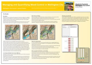
- 1. The Benefits: Description : Wellington City Council undertakes site-led programmes of pest plant management in ecologically significant sites across Wellington City. Historically these sites, and their management status, were managed non-spatially, with data recorded in spreadsheets and site reports. A way to spatially represent the sites and their status was required. Each of these sites has been overlaid with hexagonal tiling, measuring 20 metres across, and each individual hexagon assigned a weed management “control phase”. Initial control phases were assigned manually with the site knowledge of biosecurity staff and contractors. Contractors supply council biosecurity officers with monthly data consisting of GPS tracks that record where they have been within the weed management area, and point data that tells us where they have controlled, or observed, weed infestations, and what plant pest species were present. Data is provided in GPX format, and converted to file geodatabase feature classes for processing. This data is then used to determine a weed management phase. The weed management phases are based on a forest restoration framework developed by Kaitiaki o Ngahere Ltd. Each hexagon is queried several times. Firstly to determine the current phase. Secondly to determine if the ground operator visited the area: the presence of track data. And thirdly, if the contractor controlled or observed weed infestations in the area: the presence of point data. Cost Savings Resulting From Greater Efficiency: Working with contractors to improve the quality of data provided was the first step in reducing time spent cleansing and processing data. ModelBuilder was used to create a tool that automates tedious and time-consuming selections by location, selections by attribute, and field calculations. What was initially up to six hours of work is now completed in under two minutes. The tool can be used by non-GIS staff, reduces input error, and puts in place a framework for consistent project outputs in the future, regardless of who is processing the data. Managing and Quantifying Weed Control in Wellington City Wellington City Council - James Preston Managing geographically: Previous methods of record keeping made it difficult to quantitatively measure the success of weed control operations. Visualising the data in an easily digestible format enables a wider range of people to understand the operations, and allows key decision makers to confidently assess its success. Applying a spatial method of record-keeping, in conjunction with a proven weed control framework, has made the management of weed control operations in Wellington City more efficient. Better Decision Making: Biosecurity managers can use the derived data to visualise control phases, and in conjunction with site reports and ground operator knowledge, determine where best to allocate resources. Maps produced using the data make it easy to identify tiles (areas in the reserves) that haven’t been visited that year, and help with management decisions. The use of weed control chemicals in urban and sub-urban reserves is of interest to a selection of stakeholders, so being able to specify where and when operations have been undertaken is useful. Improved communication: As a result of analysing the data, we have discovered that 68% of the city’s ecologically significant sites do not have any form of active weed management. This can potentially be used as a basis for requesting additional weed control resources. Several iterations of outputs were shared with ground operators to illustrate the need for good quality data, and also to show them the measurable improvement as their data quality improved. This structure of the data allows for quick analysis of plant pest species or area data which can answer information request from politicians or members of the public. Better geographic information record keeping: Incoming contractor data is stored methodically in an agreed directory structure. Communication with ground operators ensures that they see the value in consistent, accurate data collection, and data quality has improved drastically over time. All derived data is stored within a file geodatabase, using agreed naming conventions. Using a customised ModelBuilder tool to process data ensures that outputs are consistent, year-on-year. The modular design of the tool means that future improvements, changes or additions to the process can be tested and implemented quickly and efficiently. James is a GIS Officer working for Parks, Sport and Recreation at Wellington City Council. He is involved in many aspects of the business unit from asset management, to operational mapping and support, to web mapping for public consumption.