NGRREC
The document analyzes the pre-settlement drainage network of the Upper Sangamon River Basin in Illinois. The researchers used several methods to estimate the pre-settlement configuration, including analyzing early 1800s survey maps, alluvial soil maps, and topography. They found that the current channel network is 2-3 times more extensive than the pre-settlement estimates. However, over 80% of surveyed 1800s channels were within 50 meters of alluvial soils, suggesting the estimates identified similar channel locations. The expanded modern network results from significant human impacts, making the basin's natural evolution more difficult to study. Understanding pre-settlement configurations helps model drainage formation in low-relief glaciated areas.
Recommended

Recommended
More Related Content
What's hot
What's hot (19)
Similar to NGRREC
Similar to NGRREC (20)
NGRREC
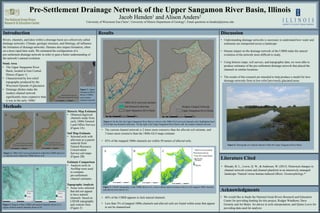
- 1. Pre-Settlement Drainage Network of the Upper Sangamon River Basin, Illinois Jacob Henden1 and Alison Anders2 University of Wisconsin Eau Claire1, University of Illinois Department of Geology2, Email questions to hendenjl@uwec.edu Introduction Results Discussion Methods Rivers, channels, and lakes within a drainage basin are collectively called drainage networks. Climate, geologic structure, and lithology, all influence the formation of drainage networks. Humans also impact formation, often on a more rapid time scale. We estimated the configuration of a pre-settlement drainage network in order to gain a better understanding of the network’s natural evolution. Study Area • The Upper Sangamon River Basin, located in East Central Illinois (Figure 1) • Characterized by low-relief topography produced by the Wisconsin Episode of glaciation. • Drainage ditches make the modern channel network significantly more expansive than it was in the early 1800s* Figure 1. Upper Sangamon River Basin (USRB) and modern channel network Figure 2. 1800s GLO surveyed channels within the USRB shown in A, alluvial soils within the USRB shown in B Historic Map Estimate • Obtained digitized channels made from early 1800s General Land Office Surveys (Figure 2A) Soil Map Estimate • Selected soils with alluvium as a parent material from Natural Resource Conservation Service soil maps (Figure 2B) Estimate Comparison • Analysis tools in ArcMap were used to compare pre-settlement channel estimates A B A B Topography Analysis • Areas were selected that did not appear to have natural channels based on LIDAR topography and contour lines (Figure 3) Figure 3. Region within USRB with natural channels shown in A, region without natural channels shown in B Literature Cited • The current channel network is 2 times more extensive than the alluvial soil estimate, and 3 times more extensive than the 1800s GLO maps estimate • 82% of the mapped 1800s channels are within 50 meters of alluvial soils. • 40% of the USRB appears to lack natural channels • Less than 3% of mapped 1800s channels and alluvial soils are found within areas that appear to not be channelized Figure 4 On the left, the Upper Sangamon River Basin is shown with 1800s GLO surveyed channels and a highlighted layer of soil that was formed in alluvium. On the right is the Upper Sangamon River Basin with the modern channel network Figure 5. LIDAR topography of the USRB shown in A, Areas without natural channels shown in B, mapped 1800s channels and alluvial soils shown in C. Acknowledgments • We would like to thank the National Great Rivers Research and Education Center for providing funding for this project, Rodger Windhorn, Dave Grimely and Art Bettis for advice in soils interpretation, and Quinn Lewis for providing data used for analysis • Rhoads, B. L., Lewis, Q. W., & Andresen, W. (2015). Historical changes in channel network extent and channel planform in an intensively managed landscape: Natural versus human-induced effects. Geomorphology.* • Understanding drainage networks is necessary to understand how water and sediments are transported across a landscape • Human impact on the drainage network of the USRB make the natural evolution of the network more difficult to study. • Using historic maps, soil surveys, and topographic data, we were able to produce estimates of the pre-settlement drainage network that placed the channels in similar locations. • The results of this research are intended to help produce a model for how drainage networks form in low-relief previously glaciated areas Figure 6. Photograph of a natural channel within the Upper Sangamon River Basin A B C