Natural_Resources_Management and Food Security.pdf
1. ENVIS Bulletin : Himalayan Ecology 16(2), 2008
ENVIS Centre, GBPIHED
NATURAL RESOURCES MANAGEMENT AND FOOD SECURITY
IN THE ALAKNANDA BASIN OF GARHWAL HIMALAYA
V. P. Sati
P.G. Department of Geography, Government Post Graduate College, Shivpuri,
Madhya Pradesh, India
E-mail: sati.vp@gmail.com
INTRODUCTION
The Alaknanda Basin in Garhwal Himalaya (Uttarakhand state) is endowed with rich
natural resources of soil, water and diverse flora and fauna. Irrational exploitation and over
utilization of natural resources has resulted in considerable amounts of soil erosion, nutrient loss
and environmental degradation in the highlands and silting of river beds causing floods, loss of
property and life in the lowlands. The Alaknanda Basin comprises eighteen development blocks
of Bageshwar, Chamoli, Rudraprayag, Tehri and Pauri Districts of Uttarakhand. The region is
characterized by difficult terrain, wide variation in slopes and altitude (650 m to above 5000 m),
high rainfall and humidity, low solar radiation and extremely low (highly elevated regions) to
very high temperatures (valley regions during the summer). Climate ranges from sub tropical to
alpine. The infrastructure facilities like roads, transport, communication, industries, health care
and agriculture are inadequate in the region. The supply of inputs, marketing, institutional credit
and extension services are still inadequate, which is resulting in the poor growth of agriculture
sector despite good potential. Majority of the population is largely dependent on agriculture and
allied land based activities.
The primitive system of cultivation is practiced widely in the basin. The inaccessibility in
dense afforested areas and rugged terrain do not provide ample opportunity for harnessing natural
resources from the mountain niche sustainably, particularly forest resources. The sustainability of
natural resources is highly vulnerable because of large scale deforestation, degradation of land,
extreme soil erosion and nutrient loss, and extinction of floral and faunal species. The natural
resources are required to be conserved, developed and harnessed on sustainable basis for ensuring
food security in the region.
1 GEO-ENVIRONMENTAL CONDITIONS
1.1 Location
The Alaknanda basin is extended between 30o
0’ N-31o
0’ N and 78o
45’ E - 80o
0’ E,
covering an area of about 10882 Km2
, represents the eastern part of the Garhwal Himalaya. Out
of the total area of the basin, 433 km2
is under glacier landscape and rest of 288 km2
under fluvial
landscape. The total number of villages is approximately 2310. The land under agriculture is
644.22 Km2
, which is 5.9 percent of the total geographical area while only 64.8 Km2
(0.6%) land
is under the horticultural crops. Fig. 1 shows location of the Alaknanda Basin in Uttarakhand
state.
1.2 Physiographic division
The Alaknanda basin is characterized predominantly by hilly terrain, deep gorges and
river valleys. The region is broadly divided into four major divisions (i) the Great Himalayan
Ranges (snow covered regions), (ii) Alpine and pasture land (covered by snow during the four
months of winter season), Middle Himalaya (characterized by highest population) and (iii) river
valleys (characterized by service centers and institutions). Among the major rivers of India, the
Alaknanda river and its tributaries (Dhauli Ganga, Vishnu Ganga, Nandakini, Pindar, Mandakini,
2. ENVIS Bulletin : Himalayan Ecology 16(2), 2008
ENVIS Centre, GBPIHED
and other numerous perennial streams) originate and flow from here. The highest mountain peaks
of the Himalayan ranges such as Nandadevi, Kamet, Trisul, and Chaukhamba are located here
Fig 1: Location map of the Alaknanda Basin
1.3 Climate: temperature and rainfall
The altitudinal differences coupled with varied physiography contributes to climatic
variations in the Alaknanda basin. The climate varies from sub-tropical to alpine. Despite diverse
physiographic characteristics, sub-regional variations in the average seasonal temperature are not
striking. Temperature varies from season to season and from valley regions to highly elevated
regions as highest temperature is recorded in Srinagar in the month of June (30o
C) and lowest in
Tungnath in the month of January (0.5o
) (Table 1). The Alaknanda basin receives heavy snowfall
about 3-4 months during winter above 2000 m altitudes. Summers are conducive and favourable
for health except a belt extending between Karanprayag to Devprayag comprising (low-lying
areas) where average monthly temperature remains about 30o
C. The farming community, during
this period migrate to upland for pastoralism. During summer, heavy flow of tourist can be seen
in the basin because this basin has two world famous pilgrimages; Badrinath and Kedarnath, five
prayags (confluence points of major rivers), and other places of cultural interest. Similarly, there
are many natural places of tourist interest.
3. ENVIS Bulletin : Himalayan Ecology 16(2), 2008
ENVIS Centre, GBPIHED
Table 1: Mean monthly temperature in the Alaknanda basin
Mean monthly temperature( o
C)
Name of
place
Altitu
de (m) Jan Feb Mar Apr May Jun July Aug Sep Oct Nov Dec
Srinagar 550 14 18 20 25 25 30 29 28 25 27 17 15
Mastura 1800 4 6 12 14 15 20 20 18 17 14 8 4
Joshimath 1875 2 3 7 11 14 17 18 17 16 10 7 4
Tungnath* 3600 0.5 1 3 6 7 12 12 11 5 4 2 1
Sources of data: * HAPPRC Srinagar Garhwal (Uttaranchal)
India Meteorological Department, Pune.
.
Rainfall mostly occurs during monsoon season from June to October. It also varies from
the valley regions (low) to highlands (high) and north-facing (leeward) to south-facing
(windward) slopes. Rainfall across five stations of the basin (Table 2) located in different
altitudes was recorded maximum in Okhimath (199.4 cm) followed by Karanprayag (147.1 cm),
while lowest rainfall was recorded in Srinagar (92.5 cm). This data reveals that higher the
altitude, higher the rainfall and vice-versa. Joshimath is located at leeward direction and recorded
lower rainfall.
Table 2: Rainfall in the Alaknanda basin
Annual rainfall
(cm)
Seasonal rainfall (%)
Station Altitude
( m)
Winter Pre-monsoon Monsoon Post-monsoon
Srinagar 550 92.5 16.0 17.7 58.8 8.5
Karanprayag 883 147.1 10.5 13.4 15.9 10.2
Okhimath 1578 199.4 8.8 11.3 71.3 8.6
Pauri 1630 130.3 14.8 14.7 61.5 9.0
Joshimath 1875 107.5 15.4 10.3 53.1 12.2
Sources of data: Forest Working Plan, Nainital Working Circle.
The basin is characterized by the presence of high moisture throughout the year. The Great
Himalayan ranges regulate the climatic conditions; as it occupy 433 km2
area of the basin. This
fact (high percentage of moisture) was noticed in 1987, when the entire India observed drought
whereas the impact of drought was negligible in the Alaknanda Basin (Sati and Kumar 2004).
2 NATURAL RESOURCES
The Alaknanda basin obtains a high degree of availability of natural resources in the form
of water, soil, flora, fauna, and climate, and consequently is rich in biodiversity and agro-climatic
conditions. The availability of these natural resources is not utilized optimally due the rough and
rugged terrain, inaccessibility and harsh climatic conditions. The condition of natural resources in
the study area is discussed as follows:
2.1 Soil resources
Soil texture varies from the Greater Himalaya to the mid-slopes and valley regions and
accordingly the potential of growing crops also varies. Soils of greater Himalaya are excessively
drained, sandy-skeletal to loamy skeletal, neutral to slightly acidic with low available water
holding capacity without profile development. In Lesser Himalaya soil is excessively drained,
sandy/loamy-skeletal/loamy with moderate erosion and moderate to strong stoniness. In the
terraces slopes, soils are moderately deep to deep, excessive drained, fine loamy, slightly to
moderately acidic with slight to moderate erosion and stoniness. Soils in glacio-fluvial valleys are
4. ENVIS Bulletin : Himalayan Ecology 16(2), 2008
ENVIS Centre, GBPIHED
excessively drained, coarse loamy, slightly acidic and moderately stony. Fluvial valley’s soils are
deep, well drained, moderately acidic, slightly eroded- Typic Dystrochrepts (Velayutham et al.
2001). Table 3 shows the chemical analysis of soils of ten sample areas of the Alaknanda basin.
These sample areas are located in different elevation ranging from 660-3000 m and characterized
by various contents and texture of soils.
Table 3: Chemical analysis of sample areas of the Alaknanda basin
Sites/structure of
localities
Elevation
(m)
PH EC
(mm/hr)
Organic
matter (%)
Nitrogen
(%)
Lithos-
stratigraphic
groups
Mana glacial drift 3000 6.50 1.10 2.40 0.01
Malari glacial drift 2760 5.40 0.11 2.50 0.30
Jelum structural terrace 2700 7.05 0.05 2.60 0.13
Central
Crystalline
Group
Joshimath terrace 1880 7.05 0.10 4.52 0.22
Helang 1800 6.50 0.11 5.00 0.30
Pipalkoti terrace 1210 7.50 0.10 1.77 0.06
Main Central
Thrust
Gaucher alluvial
terrace
1135 8.00 0.14 10.67 0.56
Nagrasu alluvial
terrace
1000 7.20 0.13 9.51 0.47
Garhwal Group
Kaliasaur alluvial
terrace
660 7.00 0.11 11.26 0.56 Pudhatoh Group
2.2 Water resources
Water is the most underutilized, at the same time most abundant resource of Himalaya. It
is estimated that about 11, 00,000 million cubic meter water flows every year down the Himalaya
offering a potential of generating electricity to the tune of 28,000 MW and making as much as
247,000 million cubic meters water available for irrigation in the Indo-Gangetic plains (Valdiya,
1985). Per capita fresh water availability in the Himalayan region is evaluated to range from 1757
m3
/yr in Indus, 1473 m3
/yr in Ganges, 18417 m3
/yr in Brahmaputra with an all India average of
2214 m3
/yr. The Alaknanda basin is endowed with bounty of water resources accounting for
about 8% of the total water resources in the country. Unfortunately, this vast potential has not
been rationally exploited yet. Endowed with huge water resources potential, it has also the worst
water resource problems rendering untold sufferings to millions every year. The region
experiences excessive rainfall and high floods during monsoon months and also suffers from
acute shortage of drinking water during summer in many areas due to lack of management. The
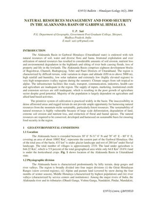
Alaknanda river (Fig. 2) and its numerous tributaries; Dhauli Ganga, Vishnu Ganga, Nandakini,
Pindar, and Mandakini and sub tributaries, which are perennial and glacial fed presents huge
water resources reservoir. In many areas, the tributaries and sub-tributaries provide ideal sites for
micro-hydropower projects. Since the area of unlimited water resources facing acute water
shortage for drinking and irrigation purposes, sustainable utilization of water through construction
of micro-hydropower projects will surely solve the duo problems. The basic issue underlying the
water resources problems are: recurring floods, drainage congestion, soil erosion, human
influence on environment and so on, and calls for its integrated use for drinking, irrigation,
generation of hydropower, and recreation.
5. ENVIS Bulletin : Himalayan Ecology 16(2), 2008
ENVIS Centre, GBPIHED
Fig. 2: The Alaknanda River flowing between Langasu and Chamoli towns in Chamoli District (Photo: V.
P. Sati)
Management of water resource in the basin is a crucial issue because of the undulating
terrain and fragility of landmasses, which does not permit for construction of macro-level dams.
Development interventions at micro-level considering drinking water, irrigation, and
hydroelectricity generation in an integrated manner have yet to be properly designed and tested.
Traditional management of water resource as a form of gharat (water mills) and gools (small
canals) did not involve any advance technology, while they are absolutely fit in this ecologically
fragile mountain terrain (Sati, 2006). Their values and efficiency rest in low levels of financial
investments, local controls, and quick responses in taking corrective actions in the event of
damages.
2.3 Forest resources
Forests are most important, both economically and environmentally among the other
natural resources in the Alaknanda basin. The geographical area covered by forest is reported to
be 1021156 hectares, which accounts for around 42.2 per cent of the study area. Ownership of the
forest in the state is mainly shared between the forest department (69.1%) and Civil and Soyam
(community forest (23.4%). Forest Panchayats (6.9%) and private (including cantonment) forests
manage the remaining area. The alpine, temperate and sub-temperate forests that cover most parts
of the basin make natural habitats of some of the best-known wildlife creatures. Alpine forests in
the region include Valley of Flowers National Park (known for its amazing variety of flowers),
Nanda Devi National Park (Figure 1), Govind Ghat National Park, and Gangotri National Park.
The Alaknanda basin is very rich in terms of forest and its diversity. Right from the
valley region to the highly elevated alpine meadows (locally known as Kharak or Bugyal), the
plant diversity is extensive. In the middle altitude, Pine (Pinus roxburghii) is found while in the
upper reaches, temperate coniferous forest mainly of Kharsu (Quercus semicarpifolia),Tilonj (Q.
dilatata), Rianj (Q. lanuginosa) and Banj oak (Q. leucotrichophora) are abundantly found (Sati,
2006). Except these forest types, many other fodder plants like, bhimal, kharik, kachnar are also
grown along with the agricultural fields. The main forests are: (i) Deodar (Cedrus deodara)
Forests are found between 1650 and 2300 m altitude, (ii) Blue Pine Forests (Pinus wallichiana)
are found in Joshimath area between 1650 and 2300 m altitude. The timber of these two species is
used in making sturdy cupboards and pelmets in houses, (iii) Chir Forests (Pinus roxburghii) are
found in the entire basin. Its forests exist mostly between the altitudes of 1000 and 1650 m. It is
used for making packing cases and paneling in interior decoration. It is also used as fuel wood,
(iv) Oak Forests (Quercus sp.) are found in the basin between the heights of 1325 and 1625 m
altitude. It is used for fuel wood and charcoal making. It is the best firewood having high caloric
value. It is a broad-leaved tree. (v) Fir (Abies pindrow) & Spruce (Picea smithiana) Forests are
found mostly between heights of 2300 m and 2950 m altitude.
6. ENVIS Bulletin : Himalayan Ecology 16(2), 2008
ENVIS Centre, GBPIHED
Altitude regulates diversity in flora in the Alaknanda basin. According to the altitudinal
zonation, various kinds of flora with great economic value are found. Most of the forests belts in
the basin are inaccessible. Consequently, their economic use is just negligible. In the high
altitude, these forests help to increase soil fertility, which is brought with rainwater and deposited
in the lowlands. The entire basin is ecologically fragile. Landslides and landslips are very
common, particularly during the rainy seasons. Due to heavy rainfall (occasional cloudburst) and
steep slope, this situation is further accentuated.
2.4 Agricultural resources
Agricultural practices are the main occupation of the inhabitants of the Alaknanda basin
and it is the main source of livelihood of the majority of people as about 80% population is
engaged in the production of cereal crops and livestock farming. Along with subsistence cereal
farming, rearing of animal has an equal proportion in the economy and income of the farmers.
Horticultural practices are also carried out but its proportion in terms of land cover, production,
and productivity is just negligible. The farming system in the basin is peculiar, which is based
upon the centuries old practices and carried out mainly on the narrow patches of the terraced
fields. The main crops grown are paddy, wheat, barley, millets, pulses, and oil seeds. The
economic viability of these crops is insufficient even to meet the food requirement of the
populace, but these crops are suitable for this ecologically fragile terrain. The scope for further
expansion and modernization of agriculture practices is not viable due to the fragility of terrain
and precipitous slope. Therefore, an exodus of population migrated to the foot-hills of Himalaya
for the search of job or recruited in National Army. Enhancing and diversifying the livelihood
options, other than biomass based production, will definitely raise the income and food-security
of the rural mountain people. This study reveals that the scope of cultivation of off-season
vegetables, fruits, medicinal plants and collection of non-timber based forest products are
tremendous. It is suggested that the optimum harnessing of these products will surely provide a
base for sustainable livelihood in the region.
2.5 Land use pattern
In the Alaknanda basin, largest percentage of geographical area is covered by snow-clad
mountain peaks, rocky and precipitous surface, and barren land (21.3%), which is no more useful
for cultivation and other development activities. About 42.2% land is covered by forest. Pasture
land and land under horticulture occupy 7.6 and 6.8% area, respectively while net sown and gross
sown area is 9.2 and 13.9%, respectively.This figure also varies from one block to another
developmental block. For example, Joshimath block has only 1% net sown area and Karnprayag
block has 18.4% net sown area (Table 4).
Table 4: Land use pattern in the Alaknanda Basin (ha) in 2004. Values in parentheses are percentage area.
Block
Total
geographical
land
Forestland Pastureland
Land under
horticulture
crops
Net sown
area
Gross
sown area
Joshimath 245877 39774 (16.2) 17849 (7.3) 17842 (7.3) 2282 (1.0) 3122 (1.3)
Karanprayag 28504 6213 (21.8) 4838 (17.0) 3338 (11.7) 5242
(18.4)
8252
(29.0)
Dasholi 40997 16794 (41.0) 6811 (16.2) 3736 (9.1) 5417
(13.2)
6680
(16.3)
Ghat 13366 5932 (44.4) 2212 (16.5) 802 (6.0) 1788
(13.4)
3091
(23.1)
Narain Bagar 18750 4143 (22.1) 3959 (21.1) 2732 (14.6) 4902
(26.1)
7121
(38.0)
Gairsain 37672 12867 (41.2) 7184 (19.1) 2742 (7.3) 5050
(13.4)
8067
(21.4)
Tharali 15333 6537 (44.6) 1565 (10.2) 1260 (8.2) 3708 4407
7. ENVIS Bulletin : Himalayan Ecology 16(2), 2008
ENVIS Centre, GBPIHED
(24.2) (28.7)
Dewal 24592 9970 (40.5) 1923 (7.8) 4514 (18.4) 1870 (7.6) 2640
(10.7)
Pokhari 27150 8225 (30.3) 3356 (12.4) 4032 (14.8) 4118
(15.2)
8334
(30.7)
Okhimath 52778 27577 (52.3) 1654 (3.1) 2897 (5.5) 4124 (7.8) 6294
(11.9)
Augustmuni 131419 68668 (52.3) 4119 (3.1) 7212 (5.5) 10268
(7.8)
15671
(11.9)
Jakholi 59511 31095 (52.3) 1865 (3.1) 3266 (5.5) 4649 (7.8) 7096
(11.9)
Devprayag 37398 13506 (36.1) 59 (0.2) 11 (0.02) 9721
(26.0)
15641
(41.8)
Kirtinagar 57704 40039 (69.4) 30 (0.05) 11 (0.01) 8578
(14.9)
13792
(23.9)
Kot 41633 24061 (57.8) 1323 (3.2) 2059 (4.9) 5213
(12.5)
7050
(16.9)
Pauri 41584 22320 (53.7) 1964 (4.7) 5271 (12.7) 4955
(11.9)
6241
(15.0)
Khirsu 40023 27176 (67.9) 1189 (3.0) 1899 (4.7) 3735 (9.3) 5438
(13.6)
Kapkot 106865 65885 (61.7) 16082 (15.0) 5883 (5.5) 7815 (7.3) 13474
(12.6)
Total 1021156 430782
(42.2)
77982 (7.6) 69507 (6.8) 93495
(9.2)
142411
(13.9)
Source of data: Statistical diaries of Chamoli, Rudraprayag, Bageshwar, Tehri, and Pauri Districts.
3 FOOD SECURITY
The carrying capacity of the Alaknanda basin is decreasing day by day due to the heavy
pressure of population. A majority of the rural people does not get sufficient nutrition in their
diet; consequently they suffer from nutrition deficiency related diseases (Pant, 1996). Natural
resources as a form of minerals and petroleum products are lagged behind in the region.
Therefore, the area is industrially backward. Furthermore, whatever the minerals are found they
are not properly mined because of the fragility of terrain. Heavy investment and lack of
technological development, on the other hand, are making the process of utilization of these
resources slow. But the availability of forests resources, agricultural crops, extensive grasslands,
varieties of herbs, flowers, fruits, vegetables, water, rearing of animals, goats and sheep is high.
The feasible climatic conditions boost up the suitability for growing horticultural crops, on the
one hand and on the other, they play a vital role for sustainability of the populace. Cultivation of
fruit crops, herbs, flowers, off-season vegetables, high yield variety (HYV) of animals, and tea
garden practices can be improved with scientific inputs. Tourism can also be practiced to improve
the economy and augmentation of employment. But owing to fragility of mountain terrain and
poor infra-structural facilities, these resources of the region could not be utilized properly,
particularly the forest and water resources.
Crop yield is low in hills as compared to that in plains (Kumar and Tripathi, 1989). The
region have relatively infertile land with poor irrigation facilities. Difficulties in using modern
technology and little use of modern inputs are because of both unsuitability and non-availability.
The productivity per capita in the region was 173 kg, while national average is 220 kg.
Agriculture is practiced in the river valleys and sloping hills (a small 10-15% of the total land
area). In spite of the relative infertility of land and poor irrigation facilities, the farmers use their
land intensively. The cropping intensity of cultivated land is thus quite high. So far the hill
economy was self-contained at low level of equilibrium with low aspirations of people, but
8. ENVIS Bulletin : Himalayan Ecology 16(2), 2008
ENVIS Centre, GBPIHED
improvement in access to other areas and increased flow of information have exposed the people
to the higher and different standards of living elsewhere, resulting in raised aspiration (Papola,
1996), which cannot be satisfied by the traditional farming. Unsustainability of agriculture and
lack of other economic opportunities together with higher literacy rate in the hill region lead to
very high rate of out migration of the youth in search of martial jobs (Khanka, 1984). With
increasing needs as well as pressure of population, the traditional farming has become
unsustainable both economically and ecologically (ICIMOD, 1996). Bhatt and Bhatt (1992) have
perceived the threat of increasing pressure on land in the region, and as the human pressure on
land increases extensive tracts of UP mountain, slopes are put under plough, fertile lands are
reduced and the food becomes scarce.
3.1 Production and Productivity of cereal crops
Table 5 and 6 shows production and productivity of major cereal crops in three
consecutive years from 1997-98 to 1999-2000 in Alaknanda basin. Highest production was
recorded for wheat crop (20485 MT) followed by mandua (17389), a millet crop, and paddy
(15717 MT). In pulses urd (black gram) recorded maximum production (174 MT), while in oil
seeds mustard oil recorded maximum yield (554 MT). Potato recorded 69411 MT productions in
1999-2000. Productivity of potato was recorded highest (225.36 q per ha), followed by tobacco
(80.00 q per ha).Though the production of cereals is high but per ha yield is considerably low
(wheat =13.38 q per ha and finger millet= 15.97 q/ha).
Table 5: Annual Production of major crops in Alaknanda basin (MT)
Name of crop 1997-98 1998-99 1999-2000
Food grain
Rice 18096 15271 15717
Wheat 22934 17411 20485
Barley 1943 1523 1257
Maize 279 169 226
Mandua (finger millet) 16161 14608 17389
Sanwa (Barnyard millet) 4534 4248 4001
Total food-grain 63947 53230 59075
Pulses
Urd (Black gram) 148 112 174
Masoorü (Lentil) 47 55 51
Pea 24 21 12
Arharü 57 70 88
Total pulses 276 258 325
Oilseed
Mustard 250 441 554
Linseed 5 5 8
Soybean 57 50 92
Total oilseed 312 496 654
Other crops
Potato 22928 40067 69411
Tobacco 7 7 8
Source of data: Statistical diaries of Chamoli, Rudraprayag, Bageshwar, Tehri, and Pauri Districts.
Table 6: Yield of major crops in Alaknanda basin (quintal per ha)
9. ENVIS Bulletin : Himalayan Ecology 16(2), 2008
ENVIS Centre, GBPIHED
Name of crop 1997-98 1998-99 1999-2000
Food-grain
Rice 12.49 12.80 12.74
Wheat 13.26 11.54 13.38
Barley 13.91 11.45 10.32
Maize 10.07 9.29 11.65
Manduwa (Finger millet) 13.49 13.92 15.97
Sanwa (Barnyard millet) 14.62 13.72 17.19
Total food-grain 13.17 12.64 13.97
Pulses
Urd (black gram) 4.15 2.68 4.15
Masoor (Lentil) 7.23 7.25 8.18
Pea 11.43 10.25 13.84
Arhar 6.33 5.95 7.48
Total pulses 5.18 4.08 5.35
Oil seed
Mustard 5.78 8.33 10.23
Linseed 1.47 1.23 1.83
Soybean 5.09 4.16 7.65
Total oilseed 5.36 7.16 9.26
Other crops
Potato 146.69 228.17 225.36
Tobacco 70.48 70.48 80.00
Source of data: Statistical diaries of Chamoli, Rudraprayag, Bageshwar, Tehri, and Pauri Districts.
The major crops are maize, wheat, rice, millets, oilseeds and pulses. The region is
deficient in food grains and the gap between demand and supply is widening. This could be
attributed to low use of fertilizers, traditional agricultural practices, mostly rained agriculture,
lack of availability of good seed, suitable cropping patterns, etc. (Sharma, 1995). There still exists
a lot of scope for enhancing the productivity of food crops in the region with optimum use of
nutrients (Sharma, 1992).
3.2 Agro-ecological zones
Suitable agro-climatic conditions provide a base for the cultivation of cash crops
including fruits, vegetables, medicinal plants, and other biomass based cops. These conditions
range from sub-tropical to cold climates in the Alaknanda basin. This basin can be divided into
five agro-ecological regions viz. (i) sub-tropical (656-1312 m) includes low-lying river valleys,
(ii) sub-temperate (1312-1968 m) includes lower part of mid-slopes, (iii) temperate (1968-2624
m) includes upper part of mid-slopes (iv) alpine (2624-3936 m) includes higher reaches or alpine
meadows, and (v) cold regions (above 3936 m) includes the Great Himalayan Ranges.
Table 7: Agro-ecological zones of the Alaknanda basin
Zones Altitude (m) Percentage of the
total area of the
basin
Suitability of crops
Cold >3936 49.84 Nil
Alpine 2624-3936 18.47 Varieties of herbs and flowers.
Temperate 1968-2624 11.88 All kinds of fruits particularly, apple and
nuts, vegetables; potato, ginger, turmeric,
and green vegetables and millets.
10. ENVIS Bulletin : Himalayan Ecology 16(2), 2008
ENVIS Centre, GBPIHED
Sub-temperate 1312-1968 11.23 Citrus and stone fruits, paddy, wheat,
onion and tomato, and green vegetables.
Sub-tropical 656-1312 18.58 Mango, guava, and papaya, rice, wheat,
onion, and tomato.
Source of data: Compiled by author.
4 MAJOR CONSTRAINTS OF FOOD SECURITY
In the Alaknanda basin, major constraints of food security vary from fragmentation of
agricultural land to fragility of landscape, high rate of erosion, low soils fertility, traditional
methods of cultivation, poor infrastructural facilities including lack of proper market, and finance.
Major constraints of food security are listed below:
4.1 Fragmentation of agricultural land
Fragmentation of agricultural fields does not provide a foundation for extensive and
intensive cultivation. The farmers have to walk a long distance, sometimes they have to walk >2
km from one fields to another. This reduces the capacity of farmers to work on the agricultural
fields and consequently crop yield and production. Terraced fields further accentuate the
difficulties; when the farmers provide input to cropped land as manure, plough the field, and
nourishment of crops. Because there are no means of transportation available, the farmers have to
carry the farming equipments and inputs on their shoulders.
4.2 Lack of infrastructural facilities
Lack of proper markets, finance, organized sector to encourage cash crops and
dependence on only cereal crops for subsistence, lack of proper planting material suited to
different agro-climatic situations, absence of processing units to process the surplus fruits like
apple, orange, mandarin, and other citrus fruits, poor post harvest management, non-availability
of desired expert advise to the farmers on the matters of right plantation and management
practices for good orchards, poor management of orchards, high losses of soils due to erosion,
leaching of nutrients and resultantly low productivity of soil are the main constraints in growing
cash crops in the study area.
CONCLUSION AND SUGGESTIONS
In spite of being rich in natural resources, the basin has not been able to provide for
endured supplies of food on sustainable basis. Harnessing of natural resources such as water,
forest, and suitable agro-ecological conditions will enhance the food security optimally and
achieve sustainable development in the basin. Improvement in traditional agricultural practices
with integrated watershed management approach is the best solution for the problems related with
sustainability of production systems and food and nutritional security of the people. Furthermore,
watershed/micro-watershed based farming systems with various land uses such as a combination
of agriculture, horticulture, pastoral, livestock based, etc., need to be popularized. In the basin,
research conducted on various farming systems has shown that watershed based farming systems
are more remunerative and helpful in conservation of soil and water. Conservation of water
resources through construction of micro-hydropower plants will generate electricity and supply
water for irrigation. Optimum utilization of land resources as per land capability classification
along with new farming systems and cropping patterns, according to the local agro-climatic
conditions, would ensure higher productivity and resources sustainability. Large scale of
afforestation programmes either of timber, horticultural plants, and plantation trees of agro-
forestry importance should be encouraged largely.
11. ENVIS Bulletin : Himalayan Ecology 16(2), 2008
ENVIS Centre, GBPIHED
REFERENCES
Bhatt, H.P and Bhatt, S. 1992. Environmental Degradation in Garhwal Himalaya: Can We Stop
It? In: Environmental Management: Socio-Economic Facts Vol II (R. K. Rai, A. C.
Mohapatra and N. P.Goel eds.) pp: 117-121.
ICIMOD, 1996. Background Note for Regional Meeting of Experts on Development of Micro
Enterprises in Mountain Area. Unpublished Text (25-26 July).
Khanka, S.S. 1984. Migration from Kumaon Region: some Findings Based on Sample Study of
Pithoragarh district. Indian Journal of Labour Economics Vol. XXVI No. 4 (January) pp:
302-312.
Kumar, J. and Tripathi, R.S. 1989. Study of Yield Gap and Constraint Analysis in Major Crops at
Farm Level in Tehri District of UP, GB Pant University of Agriculture and Technology
Hill Campus Rani Chauri (Tehri Garhwal).
Papola, T.S. 1996. Development of Micro-Enterprises in Mountain Areas. Issues in Mountain
Development, ICIMOD, Kathmandu, Nepal.
Pant, B.R. 1996. The Geographical study of scheduled castes population in Uttarakhand
Himalaya (India). The Indonesian Journal of Geography 28(7): 25-30.
Sati, V. P. and Kumar, K. 2004. Uttaranchal: Dilemma of Plenties and Scarcities. New Delhi.
Mittal Publication.
Sati, 2006. Water Resource Potentials and Management in the Pindar Basin. Included in Chapter
4 of Rosenberg Water Policy forum: Preliminary Public E-consultation. A focused e-
discussion held from July 31-August 28, 2006.
http://www.banffcentre.ca/mountainculture/mtnforum/conferences/rosenberg/week2.asp
Sharma, U.C. 1992. Adequate use of fertilizer nutrients in North Eastern Hill region is the only
viable alternative to achieve self sustainability in food grains in 2000 A.D., Indian
Fertilizer Scene, Annual: 113-122.
Sharma, U.C. 1995. Socio-economic aspects of acid soil management and alternative land use
systems for North- Eastern states of India. In: Plant Soil Interaction at Low pH, R.A.
Dates et al., (eds,), Kulwar Academic Press Netherlands: pp. 689-695.
Valdiya, K.S. 1985. Himalayan tragedy. Big dams, seismicity, erosion and drying-up of springs in
Himalayan region. Central Himalayan Environment Association Bulletin. 1: 1-24.
Velayutham, M., Singh, S. P., and Jagat Ram. 2001. Soil Resource Potential of UP Himalaya. In
Rawat, MSS, Negi R. S., and Mridula Singh (ed.), Land-Use Management and
Sustainable Development in Uttaranchal Himalaya. Srinagar Garhwal. Transmedia. Pp.
50-55